Effects of Future Infrastructure Development on Threat Status and ...
Effects of Future Infrastructure Development on Threat Status and ...
Effects of Future Infrastructure Development on Threat Status and ...

You also want an ePaper? Increase the reach of your titles
YUMPU automatically turns print PDFs into web optimized ePapers that Google loves.
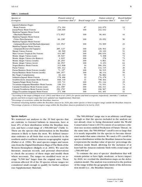
Vale et al. 5<br />
Table 1. (c<strong>on</strong>tinued)<br />
Species or Present extent <str<strong>on</strong>g>of</str<strong>on</strong>g> <str<strong>on</strong>g>Future</str<strong>on</strong>g> extent <str<strong>on</strong>g>of</str<strong>on</strong>g> Brazil habitat<br />
ecoregi<strong>on</strong> occurrence (km 2 ) a Brazil range (%) b occurrence (km 2 ) c loss (%) d<br />
Japurá/Solimões-Negro<br />
Moist Forests 274, 394 87 243, 079 13<br />
Juruá/Purus Moist Forests 248, 699 100 232, 032 7<br />
Madeira/Tapajós Moist Forest<br />
(Machado/Madeira) 172, 852 ∗ 100 96, 661 44<br />
Madeira/Tapajós Moist Forest<br />
(Teles Pires/Juruena) 66, 238 ∗ 100 29, 052 56<br />
Madeira/Tapajós Moist Forests<br />
(Aripuanã-Roosevelt/Machado-Jiparaná) 121, 954 ∗ 100 93, 909 23<br />
Madeira/Tapajós Moist Forests<br />
(Aripuanã-Roosevelt/Tapajós) 285, 123 ∗ 100 220, 564 23<br />
Marajó Várzea Forests 82, 509 100 39, 329 51<br />
Mato Grosso Tropical Dry Forests 414, 687 100 200, 634 52<br />
M<strong>on</strong>te Alegre Várzea (east) 18, 921 ∗ 100 5, 308 72<br />
M<strong>on</strong>te Alegre Várzea (rio Branco) 1, 023 ∗ 100 278 73<br />
M<strong>on</strong>te Alegre Várzea (south) 20, 294 ∗ 100 9, 861 51<br />
M<strong>on</strong>te Alegre Várzea (west) 66, 953 ∗ 100 9, 453 64<br />
Negro/Branco Moist Forests 313, 848 16 306, 254 15<br />
Purus Várzea 181, 412 81 144, 115 26<br />
Purus/Madeira Moist Forests (south) 71, 19 8∗ 100 50, 515 29<br />
Purus/Madeira Moist Forests (north) 106, 357 ∗ 100 48, 114 55<br />
Rio Negro Campinarana 82, 222 99 56, 882 31<br />
Solimões/Japurá Moist Forests 178, 406 22 176, 478 5<br />
Southwestern Amaz<strong>on</strong>ian Moist Forests 848, 149 41 798, 464 14<br />
Tapajós/Xingú Moist Forests 335, 711 100 251, 144 25<br />
Tocantins-Araguaia/Maranhão Moist Forests 198, 214 100 51, 931 74<br />
Uatumã-Trombetas Moist Forests (east) 212, 490 ∗ 100 166, 311 22<br />
Uatumã-Trombetas Moist Forests (west) 250, 270 ∗ 100 190, 567 24<br />
Xingu/Tocantins-Araguaia Moist Forest 271, 308 100 161, 401 41<br />
a According to the maps <str<strong>on</strong>g>of</str<strong>on</strong>g> Ridgely et al. (2003) <strong>and</strong> Ols<strong>on</strong> et al. (2001) for species <strong>and</strong> bird ecoregi<strong>on</strong>s, respectively. Asterisks ( ∗ ) indicate<br />
species <strong>and</strong> bird ecoregi<strong>on</strong> maps that were updated (see Supplementary Material).<br />
b Percentage <str<strong>on</strong>g>of</str<strong>on</strong>g> occurrence within the Brazilian Amaz<strong>on</strong>.<br />
c Predicted remaining habitat within the Brazilian Amaz<strong>on</strong> by 2020, plus entire species or bird ecoregi<strong>on</strong> range outside the Brazilian Amaz<strong>on</strong>.<br />
d Percentage <str<strong>on</strong>g>of</str<strong>on</strong>g> species or bird-ecoregi<strong>on</strong> range within the Brazilian Amaz<strong>on</strong> predicted to be lost by 2020.<br />
Species Analyses<br />
We restricted our analyses to the 39 bird species that<br />
are endemic to forested habitats in Amaz<strong>on</strong>ia, have at<br />
least 45% <str<strong>on</strong>g>of</str<strong>on</strong>g> their distributi<strong>on</strong> within the Brazilian Amaz<strong>on</strong>,<br />
<strong>and</strong> have a total range <str<strong>on</strong>g>of</str<strong>on</strong>g> ≤500,000 km 2 (Table 1).<br />
These are the species that deforestati<strong>on</strong> in the Brazilian<br />
Amaz<strong>on</strong> is likely to harm the most. We defined Amaz<strong>on</strong>ian<br />
endemics as all birds that occur exclusively in the<br />
southern <strong>and</strong>/or northern Amaz<strong>on</strong> zoogeographic regi<strong>on</strong><br />
(Parker et al. 1996). We used species ranges <strong>and</strong> tax<strong>on</strong>omy<br />
from the Digital Distributi<strong>on</strong> Maps <str<strong>on</strong>g>of</str<strong>on</strong>g> The Birds <str<strong>on</strong>g>of</str<strong>on</strong>g> the<br />
Western Hemisphere (Ridgely et al. 2003). We used the<br />
literature, museum records, <strong>and</strong> pers<strong>on</strong>al observati<strong>on</strong>s<br />
to check the accuracy <str<strong>on</strong>g>of</str<strong>on</strong>g> these maps <strong>and</strong> modify them<br />
where necessary. The ranges we modified were <strong>on</strong> average<br />
70,500 km 2 larger than the original <strong>on</strong>es. These<br />
revisi<strong>on</strong>s affected 18 <str<strong>on</strong>g>of</str<strong>on</strong>g> the 39 species whose ranges we<br />
c<strong>on</strong>sidered small enough to qualify for further analyses<br />
(see Supplementary Material).<br />
The 500,000-km 2 range size is an arbitrary cut<str<strong>on</strong>g>of</str<strong>on</strong>g>f large<br />
enough so that the species included in the analysis are<br />
not already close to being threatened under the World<br />
C<strong>on</strong>servati<strong>on</strong> Uni<strong>on</strong>’s (IUCN) extent <str<strong>on</strong>g>of</str<strong>on</strong>g> occurrence criteri<strong>on</strong><br />
(see secti<strong>on</strong> entitled Predicti<strong>on</strong> <str<strong>on</strong>g>of</str<strong>on</strong>g> <str<strong>on</strong>g>Future</str<strong>on</strong>g> <strong>Threat</strong>). At<br />
the same time, the 500,000-km 2 cut<str<strong>on</strong>g>of</str<strong>on</strong>g>f is not so large that<br />
it is nearly impossible for the species to become threatened<br />
under that same criteri<strong>on</strong>. We used a 45% cut<str<strong>on</strong>g>of</str<strong>on</strong>g>f for<br />
species distributi<strong>on</strong> within the Brazilian Amaz<strong>on</strong> because<br />
it represents the median value <str<strong>on</strong>g>of</str<strong>on</strong>g> species’ percentage distributi<strong>on</strong><br />
inside Brazil, allowing for the inclusi<strong>on</strong> <str<strong>on</strong>g>of</str<strong>on</strong>g> at<br />
least half the Amaz<strong>on</strong> endemic birds with a total range <str<strong>on</strong>g>of</str<strong>on</strong>g><br />
≤500,000 km 2 .<br />
To estimate the area <str<strong>on</strong>g>of</str<strong>on</strong>g> species’ distributi<strong>on</strong> that will<br />
remain pristine or have light, moderate, or heavy impact<br />
by 2020, we overlaid the distributi<strong>on</strong> maps <strong>on</strong> the deforestati<strong>on</strong><br />
model. The analysis was restricted to the porti<strong>on</strong><br />
<str<strong>on</strong>g>of</str<strong>on</strong>g> the range within the geographic limits <str<strong>on</strong>g>of</str<strong>on</strong>g> the deforestati<strong>on</strong><br />
model (i.e., the Brazilian Amaz<strong>on</strong>).<br />
C<strong>on</strong>servati<strong>on</strong> Biology<br />
Volume **, No. *, 2008