Disaster management strategy for potential slide zones of Kumarkhera in Narendra Nagar township of Tehri Garhwal district, Uttarakhand, India
Disaster management strategy for potential slide zones of Kumarkhera in Narendra Nagar township of Tehri Garhwal district, Uttarakhand, India
Disaster management strategy for potential slide zones of Kumarkhera in Narendra Nagar township of Tehri Garhwal district, Uttarakhand, India

Create successful ePaper yourself
Turn your PDF publications into a flip-book with our unique Google optimized e-Paper software.
The present communication attempts to highlight the impend<strong>in</strong>g disaster <strong>in</strong><br />
<strong>Kumarkhera</strong> locality <strong>of</strong> <strong>Narendra</strong> <strong>Nagar</strong> <strong>township</strong>, due to the existence <strong>of</strong> <strong>potential</strong><br />
<strong>slide</strong> zone, and unplanned construction activity (<strong>for</strong> bus<strong>in</strong>ess <strong>in</strong>terests), on a vulnerable<br />
slope <strong>in</strong> the area, dur<strong>in</strong>g recent years. This communication also takes note <strong>of</strong> the fact<br />
that although the hamlet town <strong>of</strong> <strong>Narendra</strong> <strong>Nagar</strong> rema<strong>in</strong>ed the adm<strong>in</strong>istrative focal<br />
po<strong>in</strong>t <strong>for</strong> <strong>Tehri</strong> <strong>Garhwal</strong> region dur<strong>in</strong>g a larger part <strong>of</strong> twentieth century, yet the<br />
selection <strong>of</strong> safe sites <strong>for</strong> residential, commercial and adm<strong>in</strong>istrative purpose was a<br />
praiseworthy disaster <strong>management</strong> practice which has gradually been abandoned<br />
dur<strong>in</strong>g past three decades or so. Furthermore, a detailed account <strong>of</strong> the land<strong>slide</strong><br />
scenario, causative factors, and <strong>management</strong> <strong>strategy</strong> <strong>for</strong> the area, has also been<br />
expla<strong>in</strong>ed <strong>in</strong> this article. Quickbird satellite images were downloaded from: http://earth.<br />
google.com and analysed <strong>for</strong> visualization and <strong>in</strong>terpretation <strong>of</strong> terra<strong>in</strong> features, land<br />
use pattern and anthropogenic activities <strong>in</strong> the area. Field <strong>in</strong>vestigations were also<br />
carried out and factors such as terra<strong>in</strong> conditions, hazard scenario, land use regulations<br />
and people’s participation were considered while <strong>for</strong>mulat<strong>in</strong>g a disaster <strong>management</strong><br />
<strong>strategy</strong> <strong>for</strong> the area.<br />
Traditional disaster <strong>management</strong> vis-à-vis unplanned construction <strong>for</strong><br />
bus<strong>in</strong>ess <strong>in</strong>terests <strong>in</strong> recent years<br />
The area under <strong>in</strong>vestigation (<strong>Kumarkhera</strong>) lies <strong>in</strong> the Earthquake High Damage Risk<br />
Zone IV. The elements <strong>of</strong> earthquake resistance can be seen <strong>in</strong> the well-ordered old<br />
civic build<strong>in</strong>gs <strong>of</strong> the neat little royal <strong>township</strong> <strong>of</strong> <strong>Narendra</strong> <strong>Nagar</strong>. Some <strong>of</strong> the<br />
build<strong>in</strong>gs like the hospital and the secretariat are still <strong>in</strong> use today. The bazaar<br />
build<strong>in</strong>gs too are a century old. The people <strong>of</strong> the area were also aware <strong>of</strong> the major<br />
hazards, namely land<strong>slide</strong>s and flash floods <strong>in</strong> this part <strong>of</strong> Himalaya. This is evident by<br />
relatively safe habitation sites <strong>of</strong> <strong>Narendra</strong> <strong>Nagar</strong> from the threat <strong>of</strong> land<strong>slide</strong>s, as the<br />
<strong>Disaster</strong><br />
<strong>management</strong><br />
<strong>strategy</strong><br />
361<br />
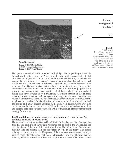
Plate 3.<br />
A 3-D view <strong>of</strong><br />
<strong>Kumarkhera</strong> area based<br />
on satellite image.<br />
Potential <strong>slide</strong> prone area<br />
with old <strong>slide</strong> scarp and<br />
toe <strong>of</strong> the old <strong>slide</strong> (on<br />
which present habitation<br />
<strong>of</strong> <strong>Kumarkhera</strong> <strong>in</strong> located)<br />
are also seen <strong>in</strong> the image