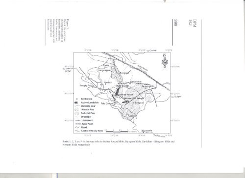
' anthropogenic <strong>in</strong>terventions <strong>in</strong> this sensitive and fragile terra<strong>in</strong>, <strong>in</strong> <strong>the</strong> <strong>for</strong>m <strong>of</strong> unplanned cutt<strong>in</strong>g <strong>of</strong> slope <strong>for</strong> construction, blast<strong>in</strong>g <strong>of</strong> highly jo<strong>in</strong>ted rock mass <strong>for</strong> road construction and unplanned disposal <strong>of</strong> <strong>the</strong> slope cut debris material, fur<strong>the</strong>r add <strong>to</strong> <strong>the</strong> vulnerability <strong>of</strong> <strong>the</strong> populations resid<strong>in</strong>g <strong>in</strong> this terra<strong>in</strong> and expose <strong>the</strong>m <strong>to</strong> <strong>the</strong> risk <strong>of</strong> natural hazards. The present communication focuses on <strong>the</strong> mass wastage-related problem around <strong>the</strong> hill <strong>to</strong>wnship <strong>of</strong> <strong>Mussoorie</strong> located <strong>in</strong> <strong>the</strong> Lesser Himalayas. Natural degradational processes <strong>to</strong>ge<strong>the</strong>r with unplanned disposal <strong>of</strong> <strong>the</strong> atmospheric precipitation and mount<strong>in</strong>g anthropogenic pressure are observed <strong>to</strong> threaten <strong>the</strong> livelihood <strong>strategy</strong> <strong>of</strong> <strong>the</strong> masses and expos<strong>in</strong>g <strong>the</strong>m <strong>to</strong> <strong>the</strong> risk <strong>of</strong> natural disasters. The micro-watershed <strong>of</strong> Rangaon-ka-Kahala <strong>to</strong>ge<strong>the</strong>r with <strong>the</strong> surround<strong>in</strong>g area <strong>of</strong> Birgaon and Kempty hous<strong>in</strong>g <strong>the</strong> <strong>landslide</strong> zone was studied <strong>in</strong> detail and a detailed <strong>management</strong> plan <strong>for</strong> <strong>the</strong> same was prepared on <strong>the</strong> basis <strong>of</strong> <strong>the</strong> satellite image <strong>in</strong>terpretation and field studies. The <strong>in</strong>dividual layers <strong>of</strong> <strong>the</strong> various geo-environmental parameters, such as faults, l<strong>in</strong>eaments, land<strong>for</strong>ms, dra<strong>in</strong>age, <strong>landslide</strong>s and <strong>the</strong> o<strong>the</strong>rs, were <strong>in</strong>tegrated us<strong>in</strong>g ARC GIS 8.3 s<strong>of</strong>tware (Figure 1). Rangaon, Rampur, Lagwalgaon and Dabla <strong>villages</strong> <strong>of</strong> Thatyur Block <strong>of</strong> Dhanolti Tehsil (district Tehri Garhwal) fall <strong>in</strong> Rangaon-ka-Khala micro-watershed (Figure 1). Overview <strong>of</strong> <strong>the</strong> area <strong>Mussoorie</strong> is a famous hill station located <strong>in</strong> <strong>the</strong> Lesser Himalayas at a distance <strong>of</strong> 26 kilometres from Dehradun, <strong>the</strong> capital <strong>of</strong><strong>Uttaranchal</strong> state <strong>of</strong> <strong>India</strong>. The <strong>to</strong>wnship is located between 1,820 and 2,100 metres above mean sea level and experiences appreciable ra<strong>in</strong>fall (annual ra<strong>in</strong>fall > 2,000mm) most <strong>of</strong> which (- 95 per cent <strong>of</strong> <strong>the</strong> <strong>to</strong>tal) is conf<strong>in</strong>ed <strong>to</strong> <strong>the</strong> monsoons. It was dur<strong>in</strong>g <strong>the</strong> British rule that <strong>Mussoorie</strong> developed <strong>in</strong><strong>to</strong> a <strong>to</strong>wnship and its population <strong>in</strong> 1881was just 3,106 (Atk<strong>in</strong>son, 1882). Increas<strong>in</strong>g economic opportunities have led <strong>to</strong> <strong>the</strong> growth <strong>of</strong> population and <strong>in</strong>frastructure and <strong>the</strong> present population <strong>of</strong> <strong>the</strong> <strong>to</strong>wn is 29,329,exclud<strong>in</strong>g <strong>the</strong> float<strong>in</strong>g population <strong>of</strong> <strong>to</strong>urists, students and o<strong>the</strong>rs. This has resulted <strong>in</strong> <strong>the</strong> hi<strong>the</strong>r<strong>to</strong> prist<strong>in</strong>e hills witness<strong>in</strong>g rigorous cutt<strong>in</strong>g <strong>of</strong> hill slope <strong>for</strong> erect<strong>in</strong>g new commercial/residential complexes, expansion <strong>of</strong> exist<strong>in</strong>g park<strong>in</strong>g spaces <strong>to</strong> cope up with <strong>the</strong> mount<strong>in</strong>g vehicular traffic, creation <strong>of</strong> educational and recreational facilities besides road cutt<strong>in</strong>g and widen<strong>in</strong>g. The vegetal cover is consequently be<strong>in</strong>g destroyed and <strong>the</strong> natural dra<strong>in</strong>age system is be<strong>in</strong>g disrupted or disturbed even <strong>in</strong> <strong>the</strong> outskirts <strong>of</strong> <strong>Mussoorie</strong> <strong>to</strong>wn, <strong>the</strong>reby caus<strong>in</strong>g <strong>the</strong> problems <strong>of</strong> slope <strong>in</strong>stability and bank erosion <strong>in</strong> <strong>the</strong> nearby <strong>villages</strong>. The <strong>Mussoorie</strong>-Yamuna bridge road l<strong>in</strong>ks <strong>the</strong> <strong>to</strong>wnship <strong>of</strong> <strong>Mussoorie</strong> <strong>to</strong> Yamuna valley and passes through Kempty Fall which is a major <strong>to</strong>urist attraction around <strong>the</strong> <strong>to</strong>wn. Severe landslid<strong>in</strong>g is observed <strong>in</strong> <strong>the</strong> vic<strong>in</strong>ity <strong>of</strong> Kempty Fall along <strong>the</strong> <strong>Mussoorie</strong>-Yamuna bridge road that is tak<strong>in</strong>g <strong>to</strong>ll <strong>of</strong> <strong>the</strong> agricultural and community <strong>for</strong>est land and threatens <strong>the</strong> livelihood<strong>strategy</strong> <strong>of</strong> <strong>the</strong> people and <strong>the</strong> existence <strong>of</strong> <strong>the</strong> habitations around. The vehicular trdffic along <strong>Mussoorie</strong>-Yamuna bridge mo<strong>to</strong>r road <strong>to</strong>ge<strong>the</strong>r with o<strong>the</strong>r l<strong>in</strong>k roads (Kempty-Thatyur and Kempty-Charogi)also faces high risk <strong>of</strong> <strong>landslide</strong> hazard (Figure 1). The geomorphic set-up <strong>of</strong> <strong>the</strong> area is def<strong>in</strong>ed by <strong>the</strong> highly dissected denudo - structural hills that have witnessed gravity transport with <strong>the</strong> <strong>villages</strong> <strong>of</strong> Rampur, Langwalgaon, Biragaon and Bamangaon be<strong>in</strong>g located on colluvial deposits. Rangaon <strong>Disaster</strong> <strong>management</strong> <strong>strategy</strong> 379 -
~@@~§"[g.g::;1 g: 0. 5' ;::;:-0. ~ '1j IIQ S" ::3 I» .m \!?._. 0 e; g. (t) ~ =:o:~ ::::-~ ~~~~lR&.if~ *