Remote Sensing and Water management - FEFlow
Remote Sensing and Water management - FEFlow
Remote Sensing and Water management - FEFlow
SHOW LESS

Create successful ePaper yourself
Turn your PDF publications into a flip-book with our unique Google optimized e-Paper software.
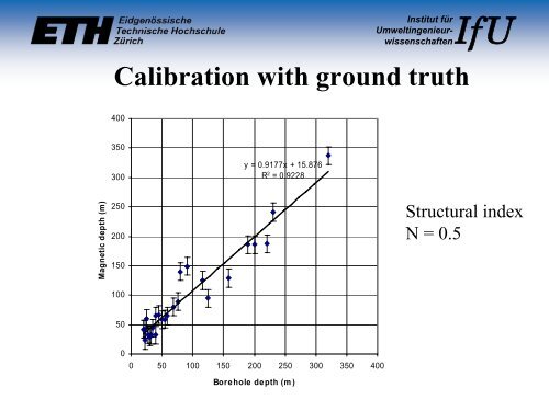
Magnetic depth (m)<br />
Institut für<br />
UmweltingenieurwissenschaftenIfU<br />
Calibration with ground truth<br />
400<br />
350<br />
300<br />
250<br />
200<br />
150<br />
100<br />
50<br />
0<br />
y = 0.9177x + 15.876<br />
R 2 = 0.9228<br />
0 50 100 150 200 250 300 350 400<br />
Borehole depth (m)<br />
Structural index<br />
N = 0.5