Proposed Plan - Former Fort Ord - Environmental Cleanup
Proposed Plan - Former Fort Ord - Environmental Cleanup
Proposed Plan - Former Fort Ord - Environmental Cleanup

Create successful ePaper yourself
Turn your PDF publications into a flip-book with our unique Google optimized e-Paper software.
Superfund <strong>Proposed</strong> <strong>Plan</strong><br />
Remedial Action is <strong>Proposed</strong> For Impact Area Munitions Response Area,<br />
Track 3 Munitions Response Remedial Investigation / Feasibility Study,<br />
<strong>Former</strong> <strong>Fort</strong> <strong>Ord</strong>, California<br />
United States Department of the Army June 25, 2007<br />
INTRODUCTION<br />
The United States Department of the Army (Army) is presenting this <strong>Proposed</strong> <strong>Plan</strong>* for the public to review and<br />
comment regarding cleanup of the Impact Area Munitions Response Area (Impact Area MRA), one of the<br />
Track 3 Munitions Response Remedial Investigation/Feasibility Study sites (Track 3 MR RI/FS sites) at the<br />
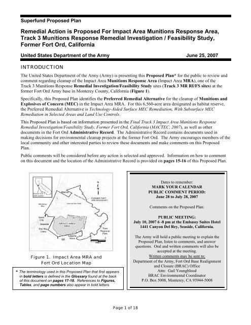
former <strong>Fort</strong> <strong>Ord</strong> Army base in Monterey County, California (Figure 1).<br />
Specifically, this <strong>Proposed</strong> <strong>Plan</strong> identifies the Preferred Remedial Alternative for the cleanup of Munitions and<br />
Explosives of Concern (MEC) in the Impact Area MRA. For this 6,560-acre area designated as habitat reserve,<br />
the Preferred Remedial Alternative is Technology-Aided Surface MEC Remediation, With Subsurface MEC<br />
Remediation in Selected Areas and Land Use Controls.<br />
This <strong>Proposed</strong> <strong>Plan</strong> is based on information presented in the Final Track 3 Impact Area Munitions Response<br />
Remedial Investigation/Feasibility Study, <strong>Former</strong> <strong>Fort</strong> <strong>Ord</strong>, California (MACTEC, 2007), as well as other<br />
documents in the <strong>Fort</strong> <strong>Ord</strong> Administrative Record. The Administrative Record contains documents used in<br />
making decisions for environmental cleanup projects at the former <strong>Fort</strong> <strong>Ord</strong>. The Army encourages members of the<br />
local community and other interested parties to review these documents and make comments on this <strong>Proposed</strong><br />
<strong>Plan</strong>.<br />
Public comments will be considered before any action is selected and approved. Information on how to comment<br />
on this document and the location of the Administrative Record is provided on pages 15-16 of this <strong>Proposed</strong> <strong>Plan</strong>.<br />
Figure 1. Impact Area MRA and<br />
<strong>Fort</strong> <strong>Ord</strong> Location Map<br />
* The terminology used in this <strong>Proposed</strong> <strong>Plan</strong> that first appears<br />
in bold letters is defined in the Glossary found at the back<br />
of this document on pages 17-18. References to Figures,<br />
Tables, and page numbers also appear in bold letters.<br />
Page 1 of 18<br />
Dates to remember:<br />
MARK YOUR CALENDAR<br />
PUBLIC COMMENT PERIOD:<br />
June 28 to July 28, 2007<br />
Comments on the <strong>Proposed</strong> <strong>Plan</strong>:<br />
PUBLIC MEETING:<br />
July 10, 2007 6 -8 pm at the Embassy Suites Hotel<br />
1441 Canyon Del Rey, Seaside, California.<br />
The Army will hold a public meeting to explain the<br />
<strong>Proposed</strong> <strong>Plan</strong>, listen to comments, and answer<br />
questions. Oral and written comments will also be<br />
accepted at the meeting.<br />
Written comments may be sent to:<br />
Department of the Army, <strong>Fort</strong> <strong>Ord</strong> Base Realignment<br />
and Closure (BRAC) Office<br />
Attn: Gail Youngblood<br />
BRAC <strong>Environmental</strong> Coordinator<br />
P.O. Box 5008, Monterey, CA 93944-5008
The Army has evaluated remedial alternatives to clean up<br />
MEC in the Impact Area MRA, described in the Track 3 Impact<br />
Area MRA RI/FS (MACTEC, 2007). The purposes of this<br />
<strong>Proposed</strong> <strong>Plan</strong> are to:<br />
• Provide background information.<br />
• Describe the remedial options considered.<br />
• Identify the Preferred Alternative for remedial action and<br />
explain the reasons for the preference.<br />
• Solicit public review and comment of the alternatives<br />
described.<br />
• Provide information on how the public can be involved in<br />
the remedy selection process.<br />
The flow chart shown on Figure 2 summarizes the Impact Area<br />
Page 2 of 18<br />
Superfund <strong>Proposed</strong> <strong>Plan</strong>, Impact Area MRA<br />
MRA Track 3 decision-making process that includes public and regulatory agency involvement and approval of the<br />
proposed remedy.<br />
Conduct Remedial Investigation/Feasibility<br />
Study (RI/FS). Prepare RI/FS Report<br />
(Final RI/FS Report, June 2007).<br />
Prepare and distribute a <strong>Proposed</strong> <strong>Plan</strong>.<br />
Provide notice of the public comment period<br />
and public meeting in a major local<br />
newspaper.<br />
Collect public comments on the <strong>Proposed</strong><br />
<strong>Plan</strong> during a public meeting and 30-day<br />
public comment period.<br />
Outline the final agency-approved action<br />
and responses to public comments in the<br />
Record of Decision.<br />
Figure 2. Track 3 Impact Area<br />
MRA Record of Decision Process<br />
The Army is the responsible party and lead agency for<br />
investigating, reporting, making cleanup decisions, and taking<br />
cleanup actions at the former <strong>Fort</strong> <strong>Ord</strong>. This <strong>Proposed</strong> <strong>Plan</strong> for the<br />
Impact Area MRA is part of the Army’s community relations<br />
program, a component of the requirements of Section 117(a) of the<br />
Comprehensive <strong>Environmental</strong> Response, Compensation, and<br />
Liability Act (CERCLA) or Superfund, and follows U.S.<br />
<strong>Environmental</strong> Protection Agency (EPA) guidance (EPA, 1989).<br />
Public comments on this <strong>Proposed</strong> <strong>Plan</strong> will be accepted during a<br />
public meeting and during the 30-day public review and comment<br />
period. The Army and the EPA in consultation with the California<br />
<strong>Environmental</strong> Protection Agency (Cal/EPA), Department of<br />
Toxic Substances Control (DTSC), will consider public comments<br />
and make a final decision in a Record of Decision (ROD). The<br />
selected remedy will be implemented for the Impact Area MRA to<br />
clean up MEC and to manage the risk to future land users from any<br />
MEC that could potentially remain after the cleanup. Army<br />
responses to public comments on this <strong>Proposed</strong> <strong>Plan</strong> will appear in<br />
the "Responsiveness Summary" section of the ROD. The flow<br />
chart shown on Figure 2 summarizes the development and<br />
approval process for the Impact Area MRA Track 3 ROD.<br />
The Impact Area MRA includes two areas previously evaluated in<br />
the Interim Action program; a southern portion of Ranges 43-48,<br />
and Range 30A. These areas were evaluated as part of the Track 3<br />
Impact Area MRA. When selected in the Track 3 Record of<br />
Decision (Track 3 ROD), the remedy is intended to serve as the<br />
final remedy for these two interim action areas. In effect, the<br />
Track 3 ROD will amend the Interim Action ROD regarding the<br />
southern portion of Ranges 43-48 and Range 30A (Army, 2002).<br />
SUMMARY OF IMPACT AREA MRA SITE CHARACTERISTICS<br />
This <strong>Proposed</strong> <strong>Plan</strong> contains terms adopted by<br />
the Army for the overall <strong>Fort</strong> <strong>Ord</strong> Military<br />
Munitions Response Program (MMRP),<br />
formerly known as the <strong>Fort</strong> <strong>Ord</strong> <strong>Ord</strong>nance and<br />
Explosives (OE) <strong>Cleanup</strong> Program. Military<br />
munitions terms used in this <strong>Proposed</strong> <strong>Plan</strong> are<br />
defined in the Glossary found on pages 17<br />
and 18. Specifically, the term munitions and<br />
explosives of concern (MEC) is used in this<br />
<strong>Proposed</strong> <strong>Plan</strong> in place of two different terms<br />
used by the Army in past OE <strong>Cleanup</strong> Program<br />
documents to indicate explosive munitions<br />
items: (1) ordnance and explosives (OE), and<br />
(2) unexploded ordnance (UXO).<br />
The historical Impact Area is located in the southwestern portion of the former <strong>Fort</strong> <strong>Ord</strong>, bounded by Eucalyptus<br />
Road to the north, Barloy Canyon Road to the east, South Boundary Road to the south, and General Jim Moore<br />
Boulevard to the west. The Impact Area MRA consists of the 6,560-acre portion of the 8,000-acre historical Impact
Area that is entirely within the natural resources management<br />
area described in the Installation-Wide Multispecies Habitat<br />
Management <strong>Plan</strong> for <strong>Former</strong> <strong>Fort</strong> <strong>Ord</strong>, California (HMP;<br />
USACE, 1997) (Figure 1). The Impact Area MRA is to be<br />
managed as a “habitat reserve” by the future landowner after<br />
the selected remedy has been completed by the Army and the<br />
property is transferred. The currently identified future<br />
recipient of the Impact Area MRA property is the Bureau of<br />
Land Management (BLM). BLM is currently preparing a<br />
habitat conservation plan (HCP) for the former <strong>Fort</strong> <strong>Ord</strong>, in<br />
coordination with <strong>Fort</strong> <strong>Ord</strong> Reuse Authority and other former<br />
<strong>Fort</strong> <strong>Ord</strong> property recipients, that identifies the types of reuse<br />
activities that are planned for the future habitat reserve<br />
(Zander, 2007).<br />
The historical 8,000-acre <strong>Fort</strong> <strong>Ord</strong> Impact Area was used for<br />
military training from 1917 until base closure in 1993.<br />
Military munitions found within the Impact Area include<br />
World War I era items (Stokes mortars and 37 and 75mm<br />
projectiles), and numerous World War II and later era items<br />
including rockets, artillery and mortar projectiles, rifle and<br />
hand grenades, practice land mines, pyrotechnics, and<br />
demolition materials. Both practice and live munitions were<br />
used.<br />
Within the 6,560-acre Impact Area MRA shown on Figure 3,<br />
previous actions included MEC removals on roads, trails, and<br />
permanent fuel breaks; surface removal actions in the Watkins<br />
Gate Burn Area and Eucalyptus Fire Area; sampling in limited<br />
areas; and surface and subsurface removals in portions of<br />
MRS-Ranges 43-48. These investigations identified the<br />
following:<br />
• MEC identified within the Impact Area MRA includes,<br />
but is not limited to, high explosive and practice<br />
projectiles, high explosive and practice rockets, high<br />
explosive and practice rifle and hand grenades, high<br />
explosive and practice mortars, and pyrotechnics.<br />
• Based on existing data, the highest concentrations of MEC<br />
are expected to occur within range fans identified on<br />
historical training maps.<br />
• Previous MEC cleanup remedial actions indicate that<br />
MEC occurs on the ground surface or within 1 foot below<br />
ground surface, and the densities appear to drop off<br />
quickly below a depth of 1 foot.<br />
The Impact Area MRA is fenced, warning signs are posted,<br />
and access is controlled by the Army. The perimeter of the<br />
historical Impact Area is patrolled to detect and prevent<br />
trespassing.<br />
The Impact Area MRA is covered by dense vegetation. The<br />
dominant plant community in the Impact Area MRA is Central<br />
Maritime Chaparral (CMC). This plant community is host to<br />
Page 3 of 18<br />
Superfund <strong>Proposed</strong> <strong>Plan</strong>, Impact Area MRA<br />
BACKGROUND<br />
The former <strong>Fort</strong> <strong>Ord</strong> is located in northwestern<br />
Monterey County, California, approximately 80 miles<br />
south of San Francisco (Figure 1). The former Army<br />
base is made up of approximately 28,000 acres of land<br />
next to Monterey Bay and the cities of Seaside, Sand<br />
City, Monterey, and Del Rey Oaks to the south and<br />
Marina to the north. A Southern Pacific Railroad<br />
track and Highway 1 pass through the western portion<br />
of former <strong>Fort</strong> <strong>Ord</strong>, separating the beach from the rest<br />
of the base. Laguna Seca Recreation Area, Toro Park,<br />
and Highway 68 border former <strong>Fort</strong> <strong>Ord</strong> to the south<br />
and southeast.<br />
Since it was established in 1917, <strong>Fort</strong> <strong>Ord</strong> served<br />
primarily as a training and staging facility for infantry<br />
and cavalry troops. From 1947 to 1975, <strong>Fort</strong> <strong>Ord</strong> was<br />
a basic training center. After 1975, the 7 th Infantry<br />
Division was based at <strong>Fort</strong> <strong>Ord</strong>. <strong>Fort</strong> <strong>Ord</strong> was<br />
selected for closure in 1991. The majority of the<br />
soldiers were reassigned to other Army posts in 1993.<br />
The Army has retained a portion of former <strong>Fort</strong> <strong>Ord</strong><br />
property as the <strong>Ord</strong> Military Community (OMC) and<br />
U.S. Army Reserve Center. The remainder of <strong>Fort</strong><br />
<strong>Ord</strong> was identified for transfer to federal, state, and<br />
local government agencies and other organizations for<br />
reuse.<br />
Because cavalry, field artillery, and infantry units used<br />
the historical Impact Area for training, maneuvers,<br />
and other purposes, MEC is present both on the<br />
surface and below the ground surface in the Impact<br />
Area MRA. Military munitions typically used within<br />
the Impact Area MRA include artillery and mortar<br />
projectiles; rockets and guided missiles; rifle and hand<br />
grenades; land mines; pyrotechnics; bombs; and<br />
demolition materials.<br />
<strong>Fort</strong> <strong>Ord</strong> was placed on the National Priorities List<br />
(NPL) of Superfund sites by the EPA on February 21,<br />
1990, due to evidence of contaminated soil and<br />
groundwater. A Federal Facility Agreement (FFA)<br />
was signed in July 1990 by representatives of the<br />
Army, EPA, and the DTSC and Regional Water<br />
Quality Control Board (RWQCB) —agencies that are<br />
part of Cal/EPA. The FFA established schedules for<br />
conducting investigations and requires the cleanup<br />
process be conducted as expeditiously as possible. In<br />
1991, the basewide Remedial Investigation /<br />
Feasibility Study (RI/FS) for soil and groundwater<br />
contamination (hazardous and toxic waste or HTW)<br />
began, and <strong>Fort</strong> <strong>Ord</strong> was placed on the Base<br />
Realignment and Closure (BRAC) List.<br />
Since 1993, MEC-related field investigations,<br />
sampling, and removal activities have been conducted<br />
at many former <strong>Fort</strong> <strong>Ord</strong> sites by the Army. This<br />
investigation and removal work was focused on<br />
addressing explosive hazards. In 1998, the Army<br />
agreed to evaluate MEC at the former <strong>Fort</strong> <strong>Ord</strong> in an<br />
MR RI/FS consistent with CERCLA, and the MR<br />
RI/FS work plan was issued in 1999.
Page 4 of 18<br />
Superfund <strong>Proposed</strong> <strong>Plan</strong>, Impact Area MRA<br />
several federally threatened and endangered species as well as many other rare species. The CMC habitat at former<br />
<strong>Fort</strong> <strong>Ord</strong> is unique, in that it supports the largest known populations of Monterey spineflower and sandmat<br />
manzanita, as well as abundant populations of sand gilia, Toro manzanita, Monterey ceanothus, and other specialstatus<br />
species. Other plant communities that occur within the Impact Area MRA include inland coast woodland<br />
(about 200 acres), grassland (over 250 acres), and wetlands (about 25 acres). These richly diverse habitats support<br />
a broad array of wildlife species.<br />
Habitat management in the Impact Area MRA is essential to the protection and management of protected species<br />
within this habitat reserve, and is vital to the reuse of the former <strong>Fort</strong> <strong>Ord</strong> because it balances species losses in other<br />
areas of the former <strong>Fort</strong> <strong>Ord</strong> that are designated for development. The habitat management responsibilities of the<br />
Army and those who will reuse the former <strong>Fort</strong> <strong>Ord</strong> are compiled in the HMP and other documents (USACE, 1997).<br />
The HMP was prepared in accordance with the U.S. Fish and Wildlife Service (USFWS) Biological Opinions<br />
(USFWS, 1993, 1997a, b). Changes to the HMP have also been documented since it was published, including<br />
additional Biological Opinions (USFWS, 1999, 2002, 2005), an Assessment (Zander, 2002), a Memorandum of<br />
Understanding (BLM, Army, 2004), a Revised Attachment A Habitat Management <strong>Plan</strong> Map (USACE, 2005), and<br />
additional requirements anticipated during reuse described in the draft HCP (Zander, 2007). The HMP and these<br />
additional documents establish the guidelines for the conservation and management of plant and wildlife species<br />
and habitats that largely depend on former <strong>Fort</strong> <strong>Ord</strong> land for survival. These documents also describe planned land<br />
use and conservation and management requirements, including habitat monitoring requirements for target species<br />
within habitat reserve areas found within the Impact Area MRA.<br />
The Impact Area MRA is currently undeveloped. While the environmental investigation and cleanup is ongoing,<br />
habitat management activities such as invasive species and erosion control are implemented on a routine basis.<br />
Other activities include ecological monitoring such as plant and animal studies. These activities are conducted<br />
under the supervision of the Army and require specific training, and generally require UXO escort. No accidents<br />
involving MEC have occurred during these ongoing activities. Information regarding the remedial investigation<br />
conducted for the Impact Area MRA was presented in the RI (Volume I; MACTEC, 2007).<br />
Figure 3. Track 3 Impact Area MRA
SUMMARY OF SITE RISKS<br />
Page 5 of 18<br />
Superfund <strong>Proposed</strong> <strong>Plan</strong>, Impact Area MRA<br />
The Remedial Investigation concluded that MEC is present on the surface and in the subsurface of the Impact Area<br />
MRA, including high explosive munitions. Based on the RI, a risk assessment was conducted to evaluate the<br />
explosive risk to human health associated with MEC within the Impact Area MRA. The Impact Area MRA Risk<br />
Assessment (RI, Section 4.0, Volume I, MACTEC, 2007) utilized the <strong>Fort</strong> <strong>Ord</strong> <strong>Ord</strong>nance and Explosives Risk<br />
Assessment Protocol, which was developed to estimate the risk to future land users from MEC in terms of an<br />
“Overall MEC Risk Score” (Malcolm Pirnie, 2002). Overall MEC Risk Scores were estimated for three scenarios:<br />
(1) a baseline scenario (conditions prior to conducting any MEC removal); (2) a hypothetical surface removal afteraction<br />
scenario (estimated risk after conducting surface-only removal action at the MRA); and (3) a hypothetical<br />
removal-to-depth (intrusive investigation of all anomalies) after-action scenario (estimated risk after conducting<br />
removal-to-depth at the MRA). Overall MEC risk scores are expressed in letters A through E.<br />
Overall MEC Risk Score<br />
A B C D E<br />
Lowest Low Medium High Highest<br />
Based on the draft HCP (Zander, 2007), the types of reuse activities that are planned for the future habitat reserve<br />
upon property transfer of the Impact Area MRA include:<br />
• Route, road, and trail management and maintenance;<br />
• Habitat enhancement;<br />
• Fuel break construction and management;<br />
• Use of administrative areas;<br />
• Habitat monitoring and educational programs;<br />
• Species specific monitors and habitat enhancement;<br />
• Controlled access including restricting recreational use to established routes.<br />
These activities have varying levels of ground disturbance. In general, the results of the Risk Assessment indicated:<br />
1) Baseline (Current) Risks – The risk is the highest (E) for all reusers.<br />
2) Surface MEC Removal – The hypothetical after-action risks following implementation are medium (C) for<br />
surface-only reusers such as habitat monitors and hikers. The risk remains the highest (E) for all reusers<br />
intruding below ground surface (such as firefighters battling wildfires or creating fuel breaks, habitat<br />
workers placing stakes, performing invasive weed control or planting, or construction workers).<br />
3) Subsurface MEC Removal – The hypothetical after-action risks following implementation are the lowest<br />
(A) for surface only receptors and receptors intruding to up to 1 foot below the ground surface. The risk<br />
remains the highest (E) for deeper-intruding reusers (such as habitat workers digging below 1 foot to<br />
perform weed control or planting, and construction workers).<br />
REMEDIAL ACTION OBJECTIVES<br />
The primary Remedial Action Objectives (RAOs) for the Impact Area MRA reuse areas are to (1) reduce risks to<br />
human health and the environment, and (2) comply with Applicable or Relevant and Appropriate Requirements<br />
(ARARs) such as federal and state laws and regulations that can be used to set cleanup standards while supporting<br />
the reuse of the Impact Area as a habitat reserve. Potential ARARs that may be pertinent to implementation of each<br />
of the remedial alternatives were identified in the Impact Area MRA Feasibility Study (FS, Volume II, Table 1;<br />
MACTEC, 2007). A range of remedial alternatives were developed in the FS to clean up MEC on the property;<br />
these alternatives were evaluated against the nine CERCLA evaluation criteria specified in the EPA's RI/FS<br />
Guidance (EPA, 1989) in order to identify one that best satisfies the RAOs.
SUMMARY OF REMEDIAL ACTION ALTERNATIVES<br />
Page 6 of 18<br />
Superfund <strong>Proposed</strong> <strong>Plan</strong>, Impact Area MRA<br />
Four remedial alternatives were evaluated for the clean up of MEC that exist in the Impact Area MRA:<br />
• Alternative 1: No Further Action<br />
• Alternative 2: Technology-Aided Surface MEC Remediation and Land Use Controls<br />
• Alternative 3: Subsurface MEC Remediation and Land Use Controls<br />
• Alternative 4: Technology-Aided Surface MEC Remediation, with Subsurface MEC Remediation in Selected<br />
Areas and Land Use Controls.<br />
Although surface and subsurface MEC remediation would result in eliminating many MEC items from the site and<br />
reducing the possibility of future exposures, the risk assessment indicated that potential After Action MEC Risk<br />
scores would remain in the high range for those receptors conducting intrusive activities. Therefore, Land Use<br />
Controls (LUCs) were included as part of Remedial Alternatives 2, 3, and 4 to support safe reuse of the area as a<br />
habitat reserve, including: (1) property transfer documentation outlining use restrictions including the prohibition of<br />
unrestricted land use; (2) access management measures including regular security patrols of the Impact Area MRA<br />
perimeter and maintaining the perimeter fence and signs; (3) MEC recognition and safety training; (4) construction<br />
monitoring for intrusive activities.<br />
The Impact Area MRA is densely vegetated; therefore, in order to provide safe access for workers to conduct MEC<br />
removals, Alternatives 2, 3, and 4 all require vegetation clearance as a first step. Methods of vegetation clearance<br />
for different plant communities at the former <strong>Fort</strong> <strong>Ord</strong> were evaluated. The Impact Area MRA is designated habitat<br />
reserve, and is primarily covered by Central Maritime Chaparral (CMC). The Evaluation of Vegetation Clearance<br />
Methods Technical Memorandum, <strong>Ord</strong>nance and Explosives Remedial Investigation/Feasibility Study, <strong>Former</strong><br />
<strong>Fort</strong> <strong>Ord</strong>, California (Vegetation Clearance Technical Memorandum; Harding ESE, 2002) identified prescribed<br />
burning as the only method that can be used on a large scale within CMC and Coastal Scrub plant communities.<br />
For additional information on prescribed burning, see the Prescribed Burning Text Box on Page 7.<br />
Description of Remedial Action Alternatives<br />
The following summarizes the components of each of the four remedial action alternatives developed in the FS<br />
(Volume II; MACTEC, 2007).<br />
ALTERNATIVE 1: No Further Action—This alternative would take no further action to achieve the remedial<br />
action objectives, and is provided, as required under CERCLA and the National Contingency <strong>Plan</strong> (NCP), as a<br />
baseline for comparison to the other proposed remedial alternatives.<br />
ALTERNATIVE 2: Technology-Aided Surface MEC Remediation and Land Use Controls—It would take 8<br />
years to complete surface MEC remediation in the Impact Area MRA if 800 acres were cleaned up each year. This<br />
alternative would include the following components:<br />
• <strong>Plan</strong>ned prescribed burning of up to 800 acres per year (in a series of several small burns of approximately 100<br />
acres in size; see Prescribed Burning Text Box, page 7) to clear vegetation and provide access for MEC<br />
surface removals;<br />
• Technology-aided surface MEC removal throughout the entire Impact Area MRA, and detonation with<br />
engineering controls of any MEC identified. MEC detection instruments would be available onsite for<br />
investigation and removal of any MEC present in areas where the ground surface is not visible;<br />
• Digital mapping to provide a record of remaining anomalies and to assist future property users in identifying<br />
areas with specific MEC safety support requirements for surface or subsurface activities. Burned vegetation<br />
would be cut to provide access to the digital geophysical equipment, and post-remediation habitat monitoring<br />
would be conducted to assess the impacts of cutting vegetation; and<br />
• Implementation of Land Use Controls (MEC recognition and safety training; construction monitoring for<br />
intrusive activities; access management measures including regular security patrols of the Impact Area MRA<br />
perimeter and maintaining a perimeter fence and signs; fire suppression helicopter support for select future<br />
habitat management prescribed burns; and property transfer documentation outlining use restrictions including<br />
the prohibition of unrestricted land use).
Vegetation Clearance by Prescribed Burning<br />
Page 7 of 18<br />
Superfund <strong>Proposed</strong> <strong>Plan</strong>, Impact Area MRA<br />
The Vegetation Clearance Technical Memorandum evaluated several vegetation clearance methods that<br />
may be applicable in different plant communities, and identified prescribed burning as the only method that<br />
can be used on a large scale within CMC and Coastal Scrub plant communities. Other vegetation<br />
clearance methods were evaluated, but their use is allowable on a limited basis only, or further study is<br />
required.<br />
The major elements of prescribed burning include:<br />
• Coordination with the local air district;<br />
• Preparation of a burn prescription/burn plan outlining the objectives of the burn, burn area, and the<br />
range of environmental conditions under which the burn will be conducted; workforce and equipment<br />
resources required to ignite, manage and contain the fire; and communication procedures;<br />
• Site preparation, including establishment and maintenance of containment lines;<br />
• Conducting the burn within the range of environmental conditions established in the burn prescription;<br />
and<br />
• Follow-up operations to ensure that the fire is fully contained.<br />
Based on past experience and habitat conservation considerations, it is anticipated that prescribed burns<br />
would be conducted in stages and consist of several small burns, approximately 100 acres in size (actual<br />
size could be more or less than 100 acres depending on site-specific characteristics) over several days<br />
rather than one large burn.<br />
Regularly-maintained roads and fuelbreaks that are accessible by vehicles and fire management equipment<br />
currently divide the site into several sections (300 to 500 acres in size). These sections would be further<br />
divided by utilizing established roads and trails to the extent possible that can be expanded as temporary<br />
fuel breaks (instead of creating brand new fuel breaks through thick vegetation that would involve higher<br />
level of effort and potential avoidable habitat impacts). The sizes of the burn areas are contingent on many<br />
factors, the most important being the location and condition of major fuelbreaks (well maintained, substantial<br />
fuel breaks where a fire could be held from spreading past that location). Other factors considered are<br />
topography, slope, aspect, fuel type, fuel loading, fire behavior, and the proximity of urban/wildland<br />
interface. The actual size and configuration of burn areas would be determined by the Army fire department<br />
in charge. The fire department would determine these parameters to minimize the size and duration of each<br />
burn, to best maintain control of the burn, to minimize smoke impacts, to be able to execute the burn within<br />
the narrow meteorological window, minding also explosives safety and other technical and practical<br />
considerations. The fire department will select areas to strategically create a buffer between the Impact<br />
Area MRA and the surrounding communities to protect the communities from any potential wildfire or fire<br />
hazard. <strong>Proposed</strong> burn areas, containment lines, and supporting rationale would be described in sitespecific<br />
implementation work plans (anticipated to be prepared for each year of planned cleanup work) that<br />
would be submitted for DTSC review and EPA concurrence.<br />
Each contiguous prescribed burn area would not exceed 400 acres (separated by a minimum of 25 acres to<br />
allow a mosaic pattern consisting of difference age classes of vegetation) unless specifically coordinated<br />
with USFWS. Per the HMP, no more than 800 acres would be allowed to be prescribed burned in any given<br />
year.<br />
The Army will provide public notification of planned prescribed burns. A prescribed burn will be started only<br />
when optimum burn conditions are confirmed. Mobilization of fire management personnel and equipment,<br />
and public notification, will occur when optimum burn conditions are reasonably expected. Once mobilized,<br />
fire and management personnel, equipment, and supplies may be in place and standing by for several days.<br />
Because the Army will be waiting for appropriate atmospheric conditions rather than trying to anticipate<br />
them, the Army will not know conclusively until moments before the fire is lit that the burn will occur that<br />
particular day. In addition, multiple burn events may be conducted over a period of several days that could<br />
be interrupted by one or more days of no burning. Through community notification, the public will be advised<br />
of reasonable precautions they can take to minimize exposure to smoke from prescribed burns, such as<br />
staying indoors with doors and windows closed, and limiting outdoor activity when smoke is present.
Page 8 of 18<br />
Superfund <strong>Proposed</strong> <strong>Plan</strong>, Impact Area MRA<br />
ALTERNATIVE 3: Subsurface MEC Remediation and Land Use Controls—Due to logistical considerations,<br />
subsurface MEC removals can be accomplished for approximately 300 acres annually. At this rate, it would take<br />
22 years to complete subsurface MEC remediation in the Impact Area MRA. This alternative would include the<br />
following components.<br />
• <strong>Plan</strong>ned prescribed burning of up to 300 acres per year (in a series of several small burns of approximately 100<br />
acres in size; see Prescribed Burning Text Box, page 7) to clear vegetation and provide access to conduct<br />
MEC removals;<br />
• Technology-aided surface MEC removal, and subsurface MEC removal throughout the entire Impact Area<br />
MRA (intrusive investigation of all anomalies); and detonation with engineering controls of any MEC<br />
identified. Burned vegetation would be cut to make the site accessible for subsurface MEC removal and digital<br />
mapping;<br />
• Digital mapping to provide a digital record, and investigation of remaining anomalies;<br />
• Implementation of Land Use Controls (MEC recognition and safety training; construction monitoring for<br />
intrusive activities; access management measures including regular security patrols of the Impact Area MRA<br />
perimeter and maintaining a perimeter fence and signs; and property transfer documentation outlining use<br />
restrictions including the prohibition of unrestricted land use); and<br />
• Post-remediation habitat monitoring (collecting data on HMP species and habitats, and performing mapping,<br />
data management and evaluation, and reporting), and habitat restoration as needed.<br />
Based on a review of currently available data, a total of approximately 320 acres of the Impact Area MRA could<br />
contain significant amounts of MEC and/or metallic debris. Implementing subsurface MEC removal in these areas<br />
may require large-scale excavations that could include sifting the top 2-foot layer of soil, which would cause<br />
significant habitat impacts, including the temporary loss of listed species, seedbank, or critical habitat for the<br />
special-status species. The HMP and additional requirements currently limit the amount of temporary habitat<br />
destruction to 75 acres. It should be noted that the size of the area that would require excavation and sifting is<br />
approximate; it could only be confirmed during MEC remediation. It would also be necessary to conduct active<br />
habitat restoration, and it would be necessary to re-initiate formal consultation with the USFWS in accordance with<br />
the requirements of the Endangered Species Act.<br />
ALTERNATIVE 4: Technology-Aided Surface MEC Remediation, With Subsurface MEC Remediation in<br />
Selected Areas and Land Use Controls—This alternative assumes Technology-Aided Surface MEC Remediation<br />
is conducted throughout the entire Impact Area MRA, and Subsurface MEC Remediation would be conducted in<br />
selected areas such as fuel breaks and access roads, and selected areas in order to address specific concerns and<br />
needs. It would take 8 years to complete surface MEC remediation with subsurface MEC remediation in selected<br />
areas in the Impact Area MRA if 800 acres were cleaned up each year. This alternative would include the<br />
following components:<br />
• <strong>Plan</strong>ned prescribed burning of up to 800 acres per year (in a series of several small burns of approximately 100<br />
acres in size; see Prescribed Burning Text Box, page 7) to clear vegetation and provide access to conduct<br />
MEC removals;<br />
• Technology-Aided surface MEC removal throughout the entire Impact Area MRA, and detonation with<br />
engineering controls of any MEC identified. MEC detection instruments would be available onsite for<br />
investigation and removal of any MEC present in areas where the ground surface is not visible;<br />
• Subsurface MEC removal (intrusive investigation of all anomalies) on fuel breaks and roads essential to habitat<br />
management activities, and in selected areas that may require subsurface MEC removal for specific purposes to<br />
support the reuse (assumed to be approximately 10 percent of the Impact Area MRA);<br />
• Digital mapping to provide a record of remaining anomalies to assist future property users in identifying areas<br />
with specific MEC safety support requirements for surface or subsurface activities. Burned vegetation would<br />
be cut to provide access to the digital geophysical equipment. Anomalies within the areas identified for<br />
subsurface removal would be investigated or resolved;
Page 9 of 18<br />
Superfund <strong>Proposed</strong> <strong>Plan</strong>, Impact Area MRA<br />
• Implementation of Land Use Controls (MEC recognition and safety training; construction monitoring for<br />
intrusive activities; access management measures including regular security patrols of the Impact Area MRA<br />
perimeter and maintaining a perimeter fence and signs; fire suppression helicopter support for select future<br />
habitat management prescribed burns; and property transfer documentation outlining use restrictions including<br />
the prohibition of unrestricted land use); and<br />
• Post-remediation habitat monitoring (collecting data on HMP species and habitats, and performing mapping,<br />
data management and evaluation, and reporting), and habitat restoration as needed.<br />
For the purposes of the FS, the total area of subsurface MEC removal was assumed to be approximately 10 percent<br />
(656 acres) of the Impact Area MRA (6,560 acres), including:<br />
• Regularly maintained fuel breaks and access roads identified by the Army and future land owner for habitat<br />
management.<br />
• A minimum 100-foot buffer area along the habitat-development border of the Impact Area MRA on the habitat<br />
side of the border that is adjacent to developed areas, and would act as an additional safety zone and provide<br />
firefighters with the ability to fight wildfires that might occur within the Impact Area from the border buffer<br />
area. The firefighters would be able to temporarily widen fuel breaks under such circumstances, to protect life<br />
and property on the development side of the border. Per the HMP, fuel breaks are to be maintained on the<br />
development side of the border. The width of the buffer could be widened based on area-specific conditions<br />
that will be specified in the site-specific work plans for each phase of work. Vegetation would be allowed to<br />
regrow in the 100-foot buffer following Subsurface MEC Removal.<br />
• Other areas to address specific risk and/or reuse needs, such as proposed, future habitat restoration sites, and<br />
areas of high density anomalies and associated with sensitive-type munitions (assumed to be approximately<br />
85 acres of the Impact Area MRA) that would be candidates for subsurface MEC removals via excavation and<br />
sifting as further described below.<br />
Based on a review of currently available data, a total of approximately 85 acres of the Impact Area MRA could<br />
contain significant amounts of MEC and/or metallic debris that are associated with sensitively fuzed types of MEC<br />
that could present a significant hazard to reusers that may work in these areas if only the surface is cleared of MEC<br />
and the items are encountered. These areas are candidates for subsurface MEC removals in order to make it safe<br />
for future reusers. This effort is assumed to include sifting the top 2-foot layer of soil, which would cause<br />
significant temporary impacts and loss of listed species, seedbank, or critical habitat. It should be noted that the<br />
size of the area that would require excavation and sifting is approximate; it could only be confirmed during MEC<br />
remediation. Depending on the actual size of these large-scale excavations, it may also be necessary to re-initiate<br />
formal consultation with the USFWS in accordance with the requirements of the Endangered Species Act.<br />
EVALUATION AND COMPARISON OF ALTERNATIVES<br />
Remedial alternatives were evaluated and compared based on EPA’s nine evaluation criteria specified in EPA’s<br />
Guidance for Conducting Remedial Investigations/Feasibility Studies Under CERCLA (EPA, 1989). The<br />
evaluation and comparison of each of the four remedial action alternatives based on these nine criteria is<br />
summarized below based on their ability to achieve the following nine (9) evaluation criteria.
THRESHOLD CRITERIA<br />
Page 10 of 18<br />
Superfund <strong>Proposed</strong> <strong>Plan</strong>, Impact Area MRA<br />
1) OVERALL PROTECTION OF HUMAN HEALTH AND THE ENVIRONMENT<br />
Overall Protection of Human Health<br />
Remedial Alternative<br />
Meets<br />
Criteria?<br />
Evaluation and Comparison Summary<br />
1: No Further Action No<br />
Unsafe for the future property owner to conduct the required habitat<br />
management activities, and to the public.<br />
2: Technology-Aided Surface MEC<br />
Remediation and Land Use Controls<br />
Yes<br />
Protective of human health. Land Use Controls would provide a level of<br />
protection that would allow for proper management of the habitat reserve.<br />
Protective of human health. Provides greatest level of protection; would<br />
3: Subsurface MEC Remediation and<br />
Land Use Controls<br />
Yes<br />
remove all detected MEC on surface and in subsurface. Land Use<br />
Controls would provide a level of protection that would allow for proper<br />
management of the habitat reserve.<br />
4: Technology-Aided Surface MEC<br />
Protective of human health. Provides a high level of protection; would<br />
Remediation, With Subsurface MEC<br />
Remediation in Selected Areas and<br />
Yes<br />
remove all detected MEC on surface and reuse-specific selected areas in<br />
the subsurface. Land Use Controls would provide a level of protection<br />
Land Use Controls<br />
that would allow for proper management of the habitat reserve.<br />
1) OVERALL PROTECTION OF HUMAN HEALTH AND THE ENVIRONMENT<br />
Overall Protection of The Environment<br />
Remedial Alternative<br />
Meets<br />
Criteria?<br />
Evaluation and Comparison Summary<br />
Existing minimum requirements under HMP, and other requirements for<br />
1: No Further Action No management of the habitat such as prescribed burning and monitoring<br />
could not be implemented.<br />
Protective of environment. Prescribed burning of CMC habitat is essential<br />
for long-term management of listed and sensitive species. Prescribed<br />
2: Technology-Aided Surface MEC<br />
Remediation and Land Use Controls<br />
Yes<br />
burning and MEC removals would be performed incorporating required<br />
mitigation to avoid and reduce impacts to listed species or critical habitat<br />
for species. Post-remediation habitat monitoring would continue to be<br />
conducted.<br />
Protective of environment for majority of Impact Area MRA. Prescribed<br />
3: Subsurface MEC Remediation and<br />
Land Use Controls<br />
Yes, for<br />
majority<br />
of<br />
Impact<br />
Area<br />
MRA<br />
burning of CMC habitat is essential for long-term management of listed<br />
and sensitive species. Prescribed burning and MEC removals would be<br />
performed incorporating required mitigation to avoid and reduce impacts<br />
to listed species or critical habitat. Most significant impacts to the<br />
environment due to approximately 320 acres containing high-density<br />
anomalies anticipated to require large-scale excavations to remove<br />
subsurface MEC. Post-remediation habitat monitoring would continue to<br />
be conducted, and habitat restoration as necessary.<br />
Protective of environment for majority of Impact Area MRA. Prescribed<br />
burning of CMC habitat is essential for long-term management of listed<br />
and sensitive species. Prescribed burning and MEC removals would be<br />
4: Technology-Aided Surface MEC<br />
performed incorporating required mitigation to avoid and reduce impacts<br />
Remediation, With Subsurface MEC<br />
Remediation in Selected Areas and<br />
Yes<br />
to listed species or critical habitat. Some impacts to the environment due<br />
to approximately 85 acres containing high density anomalies associated<br />
Land Use Controls<br />
with sensitively fuzed munitions anticipated to require large-scale<br />
excavations to remove subsurface MEC for safe reuse. Post-remediation<br />
habitat monitoring would continue to be conducted, and habitat<br />
restoration as necessary.
THRESHOLD CRITERIA (Continued)<br />
Page 11 of 18<br />
Superfund <strong>Proposed</strong> <strong>Plan</strong>, Impact Area MRA<br />
2) COMPLIANCE WITH ARARS<br />
Remedial Alternative<br />
Meets<br />
Criteria?<br />
Evaluation and Comparison Summary<br />
1: No Further Action No<br />
HMP and other requirements for management of the habitat such as<br />
prescribed burning and monitoring could not be implemented.<br />
2: Technology-Aided Surface MEC<br />
Remediation and Land Use Controls<br />
Yes<br />
MEC remediation would be implemented in compliance with ARARs. HMP<br />
and other requirements for management of the habitat such as prescribed<br />
burning and monitoring could be implemented.<br />
MEC remediation would be implemented in compliance with ARARs. HMP<br />
3: Subsurface MEC Remediation and<br />
Land Use Controls<br />
Yes, for<br />
majority<br />
of<br />
Impact<br />
Area<br />
MRA<br />
and other requirements for management of the habitat such as prescribed<br />
burning and monitoring could be implemented for the majority of the<br />
Impact Area MRA. The HMP and other requirements currently limit the<br />
amount of temporary habitat destruction to 75 acres. Large-scale<br />
excavations in high-density anomaly areas of approximately 320 acres is<br />
not consistent with the HMP and other requirements. It would therefore be<br />
necessary to re-initiate formal consultation with the USFWS in accordance<br />
with the requirements of the Endangered Species Act (ESA).<br />
MEC remediation would be implemented in compliance with ARARs. HMP<br />
4: Technology-Aided Surface MEC<br />
Remediation, With Subsurface MEC<br />
Remediation in Selected Areas and Land<br />
Use Controls<br />
Yes<br />
and other requirements for management of the habitat such as prescribed<br />
burning and monitoring could be implemented for the majority of the<br />
Impact Area MRA. Approximately 85 acres of high density anomaly areas<br />
associated with sensitively fuzed munition types would require large-scale<br />
excavation; it may therefore be necessary to re-initiate formal consultation<br />
with the USFWS in accordance with the requirements of the ESA.<br />
BALANCING CRITERIA<br />
3) SHORT-TERM EFFECTIVENESS<br />
Remedial Alternative<br />
Meets<br />
Criteria?<br />
Evaluation and Comparison Summary<br />
1: No Further Action No Not effective in the short term because no action is taken.<br />
2: Technology-Aided Surface MEC<br />
Remediation and Land Use Controls<br />
3: Subsurface MEC Remediation and<br />
Land Use Controls<br />
4: Technology-Aided Surface MEC<br />
Remediation, With Subsurface MEC<br />
Remediation in Selected Areas and Land<br />
Use Controls<br />
Yes<br />
Yes<br />
Yes<br />
Workers and the community would be protected during implementation of<br />
prescribed burning, MEC removal, and land use controls via safety<br />
protocols. Prescribed burns may cause some smoke impacts to the<br />
community, which are expected to be temporary. Community notification<br />
and smoke management would minimize potential impacts from smoke.<br />
Regarding the environment, would not have significant short-term impacts.<br />
Workers and the community would be protected during implementation of<br />
prescribed burning, MEC removal, and land use controls via safety<br />
protocols. Prescribed burns may cause some smoke impacts to the<br />
community, which are expected to be temporary. Community notification<br />
and smoke management would minimize potential impacts from smoke.<br />
Due to logistical considerations involved in conducting subsurface<br />
removals, smaller areas would be cleaned up each year; therefore, this<br />
alternative would take longer to implement and complete. Regarding the<br />
environment, would have significant short-term impacts on the<br />
environment for the portions of the Impact Area MRA where areas of highdensity<br />
anomalies would require excavation and sifting.<br />
Workers and the community would be protected during implementation of<br />
prescribed burning, MEC removal, and land use controls via safety<br />
protocols. Prescribed burns may cause some smoke impacts to the<br />
community, which are expected to be temporary. Community notification<br />
and smoke management would minimize potential impacts from smoke.<br />
Regarding the environment, would have significant short-term impacts on<br />
the environment for the portions of the Impact Area MRA where areas of<br />
high density anomalies associated with sensitively fuzed munitions types<br />
would require excavation and sifting.
BALANCING CRITERIA (Continued)<br />
Remedial Alternative<br />
4) LONG-TERM EFFECTIVENESS AND PERMANENCE<br />
Meets<br />
Criteria?<br />
1: No Further Action No<br />
2: Technology-Aided Surface MEC<br />
Remediation and Land Use Controls<br />
3: Subsurface MEC Remediation and Land<br />
Use Controls<br />
4: Technology-Aided Surface MEC<br />
Remediation, With Subsurface MEC<br />
Remediation in Selected Areas and Land<br />
Use Controls<br />
Yes<br />
Yes<br />
Yes<br />
Page 12 of 18<br />
Superfund <strong>Proposed</strong> <strong>Plan</strong>, Impact Area MRA<br />
Evaluation and Comparison Summary<br />
Not effective or permanent in the long term since no further action would be<br />
taken to address MEC risks. It would be unsafe for the future property owner<br />
to conduct the required habitat management activities, and the continued<br />
presence of MEC on the ground surface would pose a hazard to the public.<br />
Provides long-term effectiveness and permanence during reuse, because all<br />
MEC detected on the surface would be removed, and land use controls would<br />
be implemented to mitigate risks from MEC potentially remaining during reuse.<br />
Provides long-term effectiveness and permanence during reuse, because all<br />
MEC detected on the surface and in the subsurface would be removed using<br />
the best appropriate technology, and land use controls would be implemented<br />
to mitigate risks from MEC potentially remaining during reuse.<br />
Provides long-term effectiveness and permanence during reuse, because all<br />
MEC detected on the surface and in selected areas of the subsurface would be<br />
removed using the best appropriate technology, and land use controls would<br />
be implemented to mitigate risks from MEC potentially remaining during reuse.<br />
5) REDUCTION OF TOXICITY, MOBILITY, OR VOLUME THROUGH TREATMENT<br />
Remedial Alternative<br />
Meets<br />
Criteria?<br />
Evaluation and Comparison Summary<br />
1: No Further Action No Does not provide reduction because no further action would be taken.<br />
2: Technology-Aided Surface MEC<br />
Remediation and Land Use Controls<br />
Yes Provides significant reduction through surface MEC removal.<br />
3: Subsurface MEC Remediation and Land<br />
Use Controls<br />
4: Technology-Aided Surface MEC<br />
Remediation, With Subsurface MEC<br />
Remediation in Selected Areas and Land<br />
Use Controls<br />
Remedial Alternative<br />
Yes<br />
Yes<br />
Meets<br />
Criteria?<br />
1: No Further Action No<br />
2: Technology-Aided Surface MEC<br />
Remediation and Land Use Controls<br />
3: Subsurface MEC Remediation and<br />
Land Use Controls<br />
4: Technology-Aided Surface MEC<br />
Remediation, With Subsurface MEC<br />
Remediation in Selected Areas and Land<br />
Use Controls<br />
Yes<br />
Yes<br />
Yes<br />
Provides greatest degree of reduction through surface and subsurface MEC<br />
removal.<br />
Provides significant reduction through surface removal and subsurface MEC<br />
removal in selected areas.<br />
6) IMPLEMENTABILITY<br />
Evaluation and Comparison Summary<br />
Not administratively feasible to implement. While the No Further Action<br />
Alternative would be easy to implement, it would not comply with ARARS. In<br />
addition, taking no further action is unacceptable in terms of safety, and the<br />
necessary approvals are not expected.<br />
Implementable from an administrative perspective. Necessary approvals to<br />
conduct MEC removals and associated habitat management could be<br />
obtained. Necessary services, equipment, and skilled workers to implement are<br />
readily available. High level of effort to implement; requires significant<br />
coordination to implement prescribed burning prior to MEC removals.<br />
Implementable from an administrative perspective. Necessary approvals to<br />
conduct MEC removals and associated habitat management could be obtained.<br />
Significant coordination required for excavation of high density anomaly areas.<br />
Necessary services, equipment, and skilled workers to implement are readily<br />
available. Highest level of effort to implement; requires significant coordination<br />
to implement prescribed burning prior to MEC removals.<br />
Implementable from an administrative perspective. Necessary approvals to<br />
conduct MEC removals and associated habitat management could be obtained.<br />
Necessary services, equipment, and skilled workers to implement are readily<br />
available. High level of effort to implement; requires significant coordination to<br />
implement prescribed burning prior to MEC removals.
BALANCING CRITERIA (Continued)<br />
7) COST<br />
Page 13 of 18<br />
Superfund <strong>Proposed</strong> <strong>Plan</strong>, Impact Area MRA<br />
Remedial Alternative Evaluation and Comparison Summary<br />
1: No Further Action No costs<br />
2: Technology-Aided Surface MEC Remediation and Land Use Controls $88.9 million<br />
3: Subsurface MEC Remediation and Land Use Controls $423.2 million<br />
4: Technology-Aided Surface MEC Remediation, With Subsurface MEC<br />
Remediation in Selected Areas and Land Use Controls<br />
$138.4 million<br />
Long Term Management Measures*<br />
* Long Term Management Measures apply to each of the Remedial Alternatives.<br />
$435,000<br />
MODIFYING CRITERIA<br />
Remedial Alternative<br />
8 & 9) STATE & COMMUNITY ACCEPTANCE<br />
Meets<br />
Criteria?<br />
1: No Further Action No<br />
2: Technology-Aided Surface MEC<br />
Remediation and Land Use Controls<br />
3: Subsurface MEC Remediation and<br />
Land Use Controls<br />
4: Technology-Aided Surface MEC<br />
Remediation, With Subsurface MEC<br />
Remediation in Selected Areas and Land<br />
Use Controls<br />
PREFERRED ALTERNATIVE<br />
No<br />
Yes<br />
Yes<br />
Evaluation and Comparison Summary<br />
Addressed in the Impact Area MRA RI/FS ROD once comments on the<br />
<strong>Proposed</strong> <strong>Plan</strong> have been received. This alternative is not expected to be<br />
acceptable to the regulatory agencies or public.<br />
Addressed in the Impact Area MRA RI/FS ROD once comments on the<br />
<strong>Proposed</strong> <strong>Plan</strong> have been received. Based on agency comments on the<br />
RI/FS, it is anticipated to not be acceptable to the regulatory agencies.<br />
Addressed in the Impact Area MRA RI/FS ROD once comments on the<br />
<strong>Proposed</strong> <strong>Plan</strong> have been received. Based on agency comments on the<br />
RI/FS, it is anticipated to be acceptable to the regulatory agencies.<br />
Addressed in the Impact Area MRA RI/FS ROD once comments on the<br />
<strong>Proposed</strong> <strong>Plan</strong> have been received. Based on agency comments on the<br />
RI/FS, it is anticipated to be acceptable to the regulatory agencies.<br />
Based on the evaluation and comparison of the four remedial alternatives, the Army proposes Alternative 4 – Technology-<br />
Aided Surface MEC Remediation, With Subsurface MEC Remediation in Selected Areas and Land Use Controls as the<br />
preferred alternative for implementation at the Impact Area MRA because it best meets the nine evaluation criteria<br />
specified in the EPA’s RI/FS Guidance (EPA, 1989).<br />
This alternative is recommended because it will achieve substantial risk reduction through MEC removal and risk<br />
management through land use controls. The alternative best balances the risk reduction and associated environmental<br />
impacts in supporting the anticipated future use of the site as a habitat reserve.<br />
At the completion of the remedial action, including the initial implementation of land use controls, the following Long<br />
Term Management Measures will be implemented: a land transfer document that outlines any land use restrictions, such<br />
as prohibition of unrestricted land use; annual monitoring and reporting; and five-year review reporting required under<br />
CERCLA. After the MEC remedial actions have been completed, and the property is transferred to the future landowner,<br />
the Army will continue to implement and maintain the Land Use Controls identified under the Preferred Alternative,<br />
which include:<br />
• MEC recognition and safety training;<br />
• Construction monitoring for intrusive activities;<br />
• Access management measures including regular security patrols of the Impact Area MRA perimeter and maintaining<br />
a perimeter fence and signs;<br />
• Fire suppression helicopter support for select future habitat management prescribed burns; and<br />
• Use restrictions as described above, and including the prohibition of unrestricted land use.
The Preferred Alternative<br />
Alternative 4: Technology-Aided Surface MEC<br />
Remediation, With Subsurface MEC Remediation in<br />
Selected Areas and Land Use Controls<br />
The Preferred Alternative includes:<br />
• Prescribed burning to clear vegetation (see page 7)<br />
• Technology-aided surface MEC removal throughout<br />
entire Impact Area MRA<br />
• Subsurface MEC removal in selected areas of the Impact<br />
Area MRA (such as fuel breaks and roads; a minimum<br />
100-foot buffer area along the habitat-development<br />
border; and other areas to address specific risks and/or<br />
reuse needs); a Technical Memorandum will be<br />
submitted to EPA and DTSC that presents an evaluation<br />
of the surface removal and if necessary, describe<br />
additional subsurface removals recommended based on<br />
the results of the initial work.<br />
• Digital mapping to provide a record of remaining<br />
anomalies to assist future property users in identifying<br />
areas with specific MEC safety support requirements.<br />
Anomalies within the areas identified for subsurface<br />
removal will be investigated or resolved.<br />
• Implementation of Land Use Controls (MEC recognition<br />
and safety training; construction monitoring for intrusive<br />
activities; access management measures including<br />
regular security patrols of the Impact Area MRA<br />
perimeter and maintaining a perimeter fence and signs;<br />
fire suppression helicopter support for select future<br />
habitat management prescribed burns; and property<br />
transfer documentation outlining use restrictions<br />
including the prohibition of unrestricted use). The Army<br />
will prepare a Land Use Control Implementation<br />
Remedial Design/Remedial Action Work <strong>Plan</strong> (LUCI<br />
RD/RAWP) describing the requirements and<br />
responsibilities for implementing and maintaining the<br />
land use controls after property transfer.<br />
• Post-remediation habitat monitoring<br />
• Habitat restoration as needed.<br />
Long Term Management Measures that will also be<br />
implemented include:<br />
• Property transfer document that outlines use restrictions<br />
• Annual Monitoring & Reporting<br />
• 5-Year Review Reporting.<br />
Based on information currently available, the lead agency<br />
believes the Preferred Alternative meets the threshold<br />
criteria and provides the best approach among the remedial<br />
alternatives with respect to the balancing and modifying<br />
criteria. The lead agency expects the Preferred Alternative<br />
to satisfy the following statutory requirements of CERCLA<br />
§121(b): 1) be protective of human health and the<br />
environment; 2) comply with ARARs (or justify a waiver);<br />
3) be cost-effective; 4) utilize permanent solutions and<br />
alternative treatment technologies or resource recovery<br />
technologies to the maximum extent practicable; and 5)<br />
satisfy the preference for treatment as a principal element<br />
(or justify not meeting the preference).<br />
Page 14 of 18<br />
Superfund <strong>Proposed</strong> <strong>Plan</strong>, Impact Area MRA<br />
The implementation of Land Use Controls will<br />
be described in the Land Use Control<br />
Implementation Remedial Design/Remedial<br />
Action Work <strong>Plan</strong> (LUCI RD/RAWP).<br />
After technology-aided surface MEC removals<br />
are completed for each phase of work described<br />
in the site-specific work plans, digital<br />
geophysical mapping will be conducted.<br />
Following the geophysical mapping the Army<br />
will review the data and prepare a Technical<br />
Memorandum to EPA and DTSC that will<br />
present an evaluation of the work completed to<br />
date and if necessary, describe additional<br />
subsurface removals recommended based on the<br />
results of the initial work. Factors that would be<br />
considered when determining whether additional<br />
actions are necessary include, but are not limited<br />
to: (1) type of MEC encountered and danger<br />
associated with MEC; (2) proximity to potential<br />
receptors; (3) density of items; and<br />
(4) consistency with ARARs. If no additional<br />
work is required this would also be documented<br />
in the Technical Memorandum along with the<br />
rationale for no further removal actions.<br />
Each Technical Memorandum would be an<br />
addendum to the site-specific work plan, and<br />
therefore, would be associated with a primary<br />
document and be disputable. To avoid impacts<br />
to the rare, threatened and endangered species,<br />
completion and agency approval of the<br />
Technical Memorandum will be expedited to<br />
allow any additional actions to be executed<br />
before the next growing season. Each Technical<br />
Memorandum and associated correspondence<br />
would be made available to the public in the<br />
Administrative Record.<br />
HOW TO MAKE COMMENTS<br />
The Army is the responsible party and lead<br />
agency for investigating, reporting, making<br />
cleanup decisions, and taking cleanup actions at<br />
the former <strong>Fort</strong> <strong>Ord</strong>. The Army, as lead agency,<br />
is soliciting public comments on the Preferred<br />
Alternative of Technology-Aided Surface MEC<br />
Remediation, With Subsurface MEC<br />
Remediation in Selected Areas and Land Use<br />
Controls, as well as other remedial action<br />
alternatives described in this <strong>Proposed</strong> <strong>Plan</strong> to<br />
manage the risk from MEC at the Impact Area<br />
MRA. The Track 3 Impact Area MRA RI/FS<br />
(MACTEC, 2007) provides a detailed site report<br />
that describes the information gathered during
Page 15 of 18<br />
Superfund <strong>Proposed</strong> <strong>Plan</strong>, Impact Area MRA<br />
the literature review and site investigations, as well as a more detailed description of the reasons for the Army's<br />
recommendation of Technology-Aided Surface MEC Remediation, With Subsurface MEC Remediation in Selected<br />
Areas and Land Use Controls. This and other reports referenced herein are available for review at the Information<br />
Repositories and the Administrative Record listed below.<br />
Public comments will be considered before any action is selected and approved. Written and oral comments on this<br />
Impact Area MRA <strong>Proposed</strong> <strong>Plan</strong> will be accepted at the public meeting/hearing scheduled on July 10, 2007 from<br />
6:00 p.m. to 8:00 p.m. at the Embassy Suites Hotel, 1441 Canyon Del Rey, Seaside, California. Representatives<br />
from the Army, EPA, and DTSC will be present at this meeting to explain the Impact Area MRA <strong>Proposed</strong> <strong>Plan</strong>,<br />
listen to concerns, answer questions, and accept public comments.<br />
Written comments will be accepted throughout the 30-day public comment period from June 28 to July 28, 2007.<br />
Correspondence should be postmarked no later than July 28, 2007 and should be sent to the attention of the U.S.<br />
Army representative at the following address (Please reference the Impact Area MRA <strong>Proposed</strong> <strong>Plan</strong> in your<br />
correspondence):<br />
Department of the Army<br />
<strong>Fort</strong> <strong>Ord</strong> Base Realignment and Closure (BRAC) Office<br />
ATTN: Gail Youngblood<br />
BRAC <strong>Environmental</strong> Coordinator<br />
P.O. Box 5008<br />
Monterey, California 93944-5008<br />
INFORMATION ACCESS<br />
U.S. Army Representative<br />
Department of the Army<br />
<strong>Fort</strong> <strong>Ord</strong> Base Realignment and Closure (BRAC) Office<br />
P.O. Box 5008<br />
Monterey, California 93944-5008<br />
Contact: Gail Youngblood, BRAC <strong>Environmental</strong> Coordinator<br />
(831) 393-1284 FAX: (831) 393-9188<br />
Hours: 8:00 am - 5:00 pm<br />
Regulatory Representatives<br />
U.S. <strong>Environmental</strong> Protection Agency, Region IX<br />
Superfund Federal Facilities <strong>Cleanup</strong> Branch<br />
75 Hawthorne Street, Mail Code SFD-8-3<br />
San Francisco, California 94105<br />
Contact: Judy Huang (415) 972-3681<br />
Hours: 8:00 am - 5:00 pm<br />
Cal/EPA Department of Toxic Substances Control, Region 2<br />
Site Mitigation/Office of Military Facilities<br />
8800 Cal Center Drive<br />
Sacramento, California 95826<br />
Contact: Roman Racca (916) 255-6407<br />
Hours: 8:00 am - 5:00 pm
Information Repositories<br />
California State University Monterey Bay (CSUMB) Library Learning Complex<br />
100 Campus Center, Bldg. 12<br />
Seaside, California 93955 (831) 582-3733<br />
For current library hours, call or visit http://library2.csumb.edu/about/hours.php<br />
Seaside Branch Library<br />
550 Harcourt Avenue<br />
Seaside, California 93955 (831) 899-2537<br />
Hours: Mon-Thurs 10:00 am-8:00 pm; Fri/Sat 10:00 am-5:00 pm<br />
Administrative Record Department Location<br />
<strong>Fort</strong> <strong>Ord</strong> Administrative Record (www.fortordcleanup.com)<br />
Building 4463 Gigling Road, Room 101<br />
<strong>Ord</strong> Military Community, California 93944-5008<br />
(831) 393-9186 / Hours: Mon-Fri 9:00 am-4:00 pm. Other hours by appointment.<br />
Closed daily, 12:00 pm to 1:30 pm and Federal holidays.<br />
REFERENCES<br />
Page 16 of 18<br />
Superfund <strong>Proposed</strong> <strong>Plan</strong>, Impact Area MRA<br />
U.S. Bureau of Land Management (BLM) and U.S. Army (Army), 2004. Memorandum of Understanding<br />
Concerning the <strong>Proposed</strong> East Garrison/Parker Flats Land-Use Modification Between the <strong>Fort</strong> <strong>Ord</strong> Reuse<br />
Authority, Monterey Peninsula College, County of Monterey. August.<br />
Department of Defense Explosives Safety Board (DDESB), 2004. Minimum Qualifications for Unexploded<br />
<strong>Ord</strong>nance (UXO) Technicians and Personnel. DDESB TP 18. December 20.<br />
Harding ESE (formerly Harding Lawson Associates [HLA]; now MACTEC Engineering and Consulting, Inc.<br />
[MACTEC]), 2002. Evaluation of Vegetation Clearance Methods Technical Memorandum, <strong>Ord</strong>nance and<br />
Explosives Remedial Investigation/Feasibility Study, <strong>Former</strong> <strong>Fort</strong> <strong>Ord</strong>, California. May.<br />
MACTEC Engineering and Consulting, Inc. (MACTEC), 2007 (formerly HLA and Harding ESE). Final Track 3<br />
Impact Area Munitions Response Area Remedial Investigation/Feasibility Study, <strong>Former</strong> <strong>Fort</strong> <strong>Ord</strong>, California.<br />
Report prepared for USACE. June 19.<br />
Malcolm-Pirnie, 2002. Final <strong>Fort</strong> <strong>Ord</strong> <strong>Ord</strong>nance and Explosives Risk Assessment Protocol. October.<br />
U.S. Army Corps of Engineers (USACE), 2005. Revised Attachment A – Habitat Management <strong>Plan</strong> Map for<br />
<strong>Former</strong> <strong>Fort</strong> <strong>Ord</strong>. April.<br />
_____, 1997. Installation-Wide Multispecies Habitat Management <strong>Plan</strong> for <strong>Former</strong> <strong>Fort</strong> <strong>Ord</strong>, California (HMP).<br />
With technical assistance from Jones and Stokes, Sacramento, California. April.<br />
U.S. Department of the Army (Army), 2002. Record of Decision, Interim Action For <strong>Ord</strong>nance and Explosives at<br />
Ranges 43-48, Range 30A, and Site OE-16, <strong>Former</strong> <strong>Fort</strong> <strong>Ord</strong>, California. August 26.<br />
U.S. <strong>Environmental</strong> Protection Agency (EPA), 1989. Guidance for Conducting Remedial Investigation/Feasibility<br />
Studies Under CERCLA. Interim Final. EPA 540/G-89/001. October.<br />
U.S. Department of the Interior, Fish and Wildlife Service (USFWS), 2005. <strong>Cleanup</strong> and Reuse of <strong>Former</strong> <strong>Fort</strong><br />
<strong>Ord</strong>, Monterey County, California, as it affects California Tiger Salamander and Critical Habitat for Contra Costa<br />
Goldfields (1-8-04-F-25R). March.<br />
_____, 2002. Biological Opinion on the Closure and Reuse of <strong>Fort</strong> <strong>Ord</strong>, Monterey County, California, as it affects<br />
Monterey Spineflower Critical Habitat, (1-8-01-F-70R). October.
Page 17 of 18<br />
Superfund <strong>Proposed</strong> <strong>Plan</strong>, Impact Area MRA<br />
_____, 1999. Biological and Conference Opinion on the Closure and Reuse of <strong>Fort</strong> <strong>Ord</strong>, Monterey County,<br />
California (1-8-99-F/C-39R). Response to Army letter dated 11/11/98 to reinitiate formal consultation in<br />
accordance with Section 7 of Endangered Species Act of 1973. March.<br />
_____, 1997a. Biological and Conference Opinion on the Closure and Reuse of <strong>Fort</strong> <strong>Ord</strong> (1-8-97-F/C-13).<br />
January.<br />
_____, 1997b. Biological and Conference Opinion on the Closure and Reuse of <strong>Fort</strong> <strong>Ord</strong>, Monterey County,<br />
California (1-8-97-F/C-23R). April.<br />
_____, 1993. Biological Opinion for the Disposal and Reuse of <strong>Fort</strong> <strong>Ord</strong>, Monterey County, California.<br />
(I-8-93-F-14). October.<br />
Zander Associates, 2002. Assessment East Garrison - Parker Flats Land Use Modifications, <strong>Fort</strong> <strong>Ord</strong>, California.<br />
May.<br />
_____, 2007. Draft Habitat Conservation <strong>Plan</strong> for <strong>Former</strong> <strong>Fort</strong> <strong>Ord</strong>, California. January<br />
GLOSSARY<br />
Administrative Record – A compilation of all documents relied upon to select a remedial action pertaining to the<br />
investigation and cleanup of <strong>Fort</strong> <strong>Ord</strong>.<br />
Applicable or Relevant and Appropriate Requirements (ARARs) – Federal and State laws and regulations<br />
pertaining to environmental cleanups that can be specific to the chemicals found at a site, the potential actions<br />
proposed to address contamination at a site, or the location of the site.<br />
Comprehensive <strong>Environmental</strong> Response, Compensation, and Liability Act (CERCLA, otherwise known as<br />
Superfund) – A federal law that addresses the funding for and cleanup of abandoned or uncontrolled hazardous<br />
waste sites. This law also establishes criteria for the creation of key cleanup documents such as the Remedial<br />
Investigation (RI), Feasibility Study (FS), <strong>Proposed</strong> <strong>Plan</strong>, and Record of Decision (ROD).<br />
Feasibility Study (FS) – An evaluation of potential remedial technologies and treatment options that can be used to<br />
clean up a site.<br />
Land Use Controls (LUC) – Land use controls are physical, legal, or administrative mechanisms that restrict the<br />
use of, or limit access to, real property, to manage risks to human health and the environment. Physical<br />
mechanisms include fences, pavement, or signs. Legal mechanisms include deed restrictions that limit how the<br />
property is used. Administrative mechanisms include providing munitions recognition training for workers who do<br />
intrusive work.<br />
Military Munitions [formerly OE] – Military munitions means all ammunition products and components produced<br />
for or used by the armed forces for national defense and security, including ammunition products or components<br />
under the control of the Department of Defense, the Coast Guard, the Department of Energy, and the National<br />
Guard. The term includes confined gaseous, liquid, and solid propellants, explosives, pyrotechnics, chemical and<br />
riot control agents, smokes, and incendiaries, including bulk explosives and chemical warfare agents, chemical<br />
munitions, rockets, guided and ballistic missiles, bombs, warheads, mortar rounds, artillery ammunition, small arms<br />
ammunition, grenades, mines, torpedoes, depth charges, cluster munitions and dispensers, demolition charges, and<br />
devices and components thereof.<br />
The term does not include wholly inert items, improvised explosive devices, and nuclear weapons, nuclear devices,<br />
and nuclear components, except that the term does include non-nuclear components of nuclear devices that are<br />
managed under the nuclear weapons program of the Department of Energy after all required sanitization operations<br />
under the Atomic Energy Act of 1954 (42 U.S.C. 2011 et seq.) have been completed. (10 U.S.C. 2710(e)(3)(A) and<br />
(B)).<br />
Military Munitions Response Program (MMRP) [formerly OE <strong>Cleanup</strong> Program] – Program established by the<br />
Department of Defense to manage environmental, health and safety issues presented by MEC.<br />
Munitions Debris [formerly OE Scrap] – Remnants of munitions (e.g., penetrators, projectiles, shell casings, links,<br />
fins) remaining after munitions use, demilitarization or disposal. Munitions debris is confirmed inert by<br />
technically-qualified personnel.
Page 18 of 18<br />
Superfund <strong>Proposed</strong> <strong>Plan</strong>, Impact Area MRA<br />
Munitions and Explosives of Concern (MEC) [formerly OE and UXO] – This term, which distinguishes specific<br />
categories of military munitions that may pose unique explosives safety risks, means: (A) Unexploded ordnance<br />
(UXO), as defined in 10 U.S.C. 101(e)(5) (A) through (C); (B) Discarded military munitions (DMM), as defined in<br />
10 U.S.C. 101(e)(4) (A) through (C); or (C) Explosive munitions constituents (e.g., TNT, RDX) present in high<br />
enough concentrations to pose an explosive hazard.<br />
Munitions Response Area (MRA) – Any area on a defense site that is known or suspected to contain MEC.<br />
Examples include former ranges and munitions burial areas. A munitions response area is made up of one or more<br />
munitions response sites.<br />
Munitions Response Site (MRS) [formerly OE Site] – A discrete location within a MRA that is known to require a<br />
munitions response.<br />
<strong>Ord</strong>nance and Explosives (OE) – Consists of either (1) or (2) below:<br />
(1) Ammunition, ammunition components, chemical or biological warfare materiel or explosives that have been<br />
abandoned, expelled from demolition pits or burning pads, lost, discarded, buried, or fired. Such ammunition,<br />
ammunition components, and explosives are no longer under accountable record control of any Department of<br />
Defense organization or activity.<br />
(2) Explosive soil, which refers to mixtures of explosives in soil, sand, clay, or other solid media at concentrations<br />
such that the mixture itself is explosive.<br />
Preferred Remedial Alternative – The remedial alternative that, when compared to other potential alternatives,<br />
was determined to best meet the nine CERCLA evaluation criteria in the Feasibility Study, and is proposed for<br />
implementation at a site.<br />
<strong>Proposed</strong> <strong>Plan</strong> – A plan that identifies the preferred alternative for a site cleanup, and is made available to the<br />
public for comment.<br />
Record of Decision (ROD) – A report documenting the final action, approved by the regulatory agencies, that is<br />
required at Superfund sites.<br />
Remedial Alternatives – Potential remedies to address contamination (in this case, MEC).<br />
Remedial Investigation (RI) – Exploratory inspection conducted at a site to define the nature and extent of<br />
chemicals, and in this case, MEC present.<br />
Superfund – See Comprehensive <strong>Environmental</strong> Response, Compensation, and Liability Act (CERCLA) above.<br />
Track 3 MR RI/FS Site – Areas where: (1) MEC are suspected or known to exist, but investigations are not yet<br />
complete or need to be initiated, or (2) any suspected or known areas identified in the future. The Impact Area<br />
MRA qualifies as a Track 3 site because MEC exist and actions have not been completed.<br />
Technology-Aided Surface MEC Remediation – A removal of UXO, DMM, or CWM on the surface (i.e., the top<br />
of the soil layer) only, in which the detection process is primarily performed visually, but is augmented by<br />
technology aids (e.g., hand-held magnetometers or metal detectors) because vegetation, the weathering of UXO,<br />
DMM, or CWM, or other factors make visual detection difficult.<br />
Unexploded <strong>Ord</strong>nance (UXO) – Military munitions that: (A) have been primed, fuzed, armed, or otherwise<br />
prepared for action; (B) have been fired, dropped, launched, projected, or placed in such a manner as to constitute a<br />
hazard to operations, installations, personnel, or material; and (C) remain unexploded either by malfunction, design,<br />
or any other cause. (10 U.S.C. 101(e)(5) (A) through (C)).<br />
UXO-Qualified Personnel – Personnel who have performed successfully in military EOD positions, or are<br />
qualified to perform in the following Department of Labor, Service Contract Act, Directory of Occupations,<br />
contractor positions: UXO Technician II, UXO Technician III, UXO Safety Officer, UXO Quality Control<br />
Specialist or Senior UXO Supervisor (DDESB, 2004).