Monitoring the Bullhead - European Commission
Monitoring the Bullhead - European Commission
Monitoring the Bullhead - European Commission

Create successful ePaper yourself
Turn your PDF publications into a flip-book with our unique Google optimized e-Paper software.
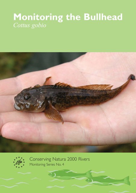
<strong>Monitoring</strong> <strong>the</strong> <strong>Bullhead</strong><br />
Cottus gobio<br />
Conserving Natura 2000 Rivers<br />
<strong>Monitoring</strong> Series No. 4
For more information contact:<br />
The Enquiry Service<br />
English Nature<br />
Northminster House<br />
Peterborough<br />
PE1 1UA<br />
Email: enquiries@english-nature.org.uk<br />
Tel: +44 (0) 1733 455100<br />
Fax: +44 (0) 1733 455103<br />
<strong>Monitoring</strong> <strong>the</strong> <strong>Bullhead</strong><br />
Conserving Natura 2000 Rivers <strong>Monitoring</strong> Series No. 4<br />
IG Cowx & JP Harvey<br />
International Fisheries Institute, University of Hull<br />
This document was produced with <strong>the</strong> support of <strong>the</strong> <strong>European</strong> <strong>Commission</strong>’s LIFE Nature Programme. It<br />
was published by Life in UK Rivers, a joint venture involving English Nature (EN), <strong>the</strong> Countryside<br />
Council for Wales (CCW), <strong>the</strong> Environment Agency (EA), <strong>the</strong> Scottish Environment Protection Agency<br />
(SEPA), Scottish Natural Heritage (SNH), and <strong>the</strong> Scotland and Nor<strong>the</strong>rn Ireland Forum for Environmental<br />
Research (SNIFFER).<br />
© (Text only) EN, CCW, EA, SEPA, SNH & SNIFFER 2003<br />
ISBN 1 85716 726 0<br />
A full range of Life in UK Rivers publications can be ordered from:<br />
The Enquiry Service<br />
English Nature<br />
Northminster House<br />
Peterborough<br />
PE1 1UA<br />
Email: enquiries@english-nature.org.uk<br />
Tel: +44 (0) 1733 455100<br />
Fax: +44 (0) 1733 455103<br />
This document should be cited as: Cowx IG & Harvey JP (2003). <strong>Monitoring</strong> <strong>the</strong> <strong>Bullhead</strong>, Cottus gobio.<br />
Conserving Natura 2000 Rivers <strong>Monitoring</strong> Series No. 4, English Nature, Peterborough.<br />
Technical Editor: Lynn Parr<br />
Series Ecological Coordinator: Ann Skinner<br />
Cover design: Coral Design Management, Peterborough.<br />
Printed by Astron Document Services, Norwich, on Revive, 75% recycled post-consumer waste paper,<br />
Elemental Chlorine Free. 1M.
Conserving Natura 2000 Rivers<br />
This protocol for monitoring <strong>the</strong> bullhead (Cottus gobio) has been produced as part of Life in UK<br />
Rivers – a project to develop methods for conserving <strong>the</strong> wildlife and habitats of rivers within <strong>the</strong><br />
Natura 2000 network of protected <strong>European</strong> sites.The project’s focus has been <strong>the</strong> conservation of<br />
rivers identified as Special Areas of Conservation (SACs) and of relevant habitats and species listed in<br />
annexes I and II of <strong>the</strong> <strong>European</strong> Union Directive on <strong>the</strong> Conservation of Natural Habitats and of Wild<br />
Fauna and Flora (92/43/EEC) (<strong>the</strong> Habitats Directive).<br />
One of <strong>the</strong> main products is a set of methods for monitoring species and habitats, which complements<br />
reports containing <strong>the</strong> best available information on <strong>the</strong>ir ecological requirements. Each report has<br />
been compiled by ecologists who are studying <strong>the</strong>se species and habitats in <strong>the</strong> UK, and has been<br />
subject to peer review, including scrutiny by a Technical Advisory Group established by <strong>the</strong> project<br />
partners. In <strong>the</strong> case of <strong>the</strong> monitoring techniques, fur<strong>the</strong>r refinement has been accomplished by fieldtesting<br />
and by workshops involving experts and conservation practitioners.<br />
Conservation strategies have also been produced for seven different SAC rivers in <strong>the</strong> UK. In <strong>the</strong>se,<br />
you can see how <strong>the</strong> statutory conservation and environment agencies have developed objectives for<br />
<strong>the</strong> conservation of <strong>the</strong> habitats and species, and drawn up action plans with <strong>the</strong>ir local partners for<br />
achieving ‘favourable conservation status’.<br />
Life in UK Rivers is a demonstration project and, although <strong>the</strong> reports have no official status in <strong>the</strong><br />
implementation of <strong>the</strong> directive, <strong>the</strong>y are intended as a helpful source of information for organisations<br />
trying to set conservation objectives and to monitor for ‘favourable conservation status’ for <strong>the</strong>se<br />
habitats and species.They can also be used to help assess plans and projects affecting Natura 2000<br />
sites, as required by Article 6.3 of <strong>the</strong> directive.<br />
Favourable conservation status<br />
The purpose of designating and managing SACs is to maintain at, or restore to,‘favourable conservation<br />
status’ <strong>the</strong> habitats and species listed on annexes I and II of <strong>the</strong> directive.<br />
The conservation status of a natural habitat can be taken as favourable when:<br />
Its natural range and areas it covers within that range are stable or increasing.<br />
The specific structure and functions necessary for its long-term maintenance exist and are<br />
likely to exist for <strong>the</strong> foreseeable future.<br />
The conservation status of its typical species is favourable.<br />
The conservation status of a species may be taken as favourable when:<br />
Population data indicate that <strong>the</strong> species is maintaining itself on a long-term basis as a viable<br />
component of its natural habitats.<br />
The species’ natural range is nei<strong>the</strong>r being reduced nor is likely to be reduced for <strong>the</strong><br />
foreseeable future.<br />
There is, and will probably continue to be, a sufficiently large habitat to maintain its<br />
populations on a long-term basis.<br />
The conservation status of a species or habitat has thus to be assessed across its entire natural range<br />
within <strong>the</strong> <strong>European</strong> Union, in both protected sites and <strong>the</strong> wider countryside, and over <strong>the</strong> long term.<br />
<strong>Monitoring</strong> techniques<br />
<strong>Monitoring</strong> <strong>the</strong> <strong>Bullhead</strong><br />
The Habitats Directive requires <strong>the</strong> condition of <strong>the</strong> habitats and species for which an SAC has been<br />
designated to be monitored, so that an evaluation can be made of <strong>the</strong> conservation status of <strong>the</strong>se<br />
features and <strong>the</strong> effectiveness of management plans. An assessment of conservation status must,<br />
<strong>the</strong>refore, be applied at both site and network level.<br />
1
Conserving Natura 2000 Rivers<br />
Standard monitoring methods and a coherent assessment and reporting framework are essential to<br />
allow results to be both compared and aggregated within and across EU member states.<br />
While <strong>the</strong> directive outlines <strong>the</strong> data reporting required from member states at a national level, it did<br />
not set out detailed assessment techniques for data collection at habitat and species level.<br />
The Conserving Natura 2000 Rivers series of monitoring protocols seeks to identify monitoring<br />
methods and sampling strategies for riverine species and <strong>the</strong> Ranunculus habitat type that are fieldtested,<br />
cost-effective, and founded on best scientific knowledge.<br />
Titles in <strong>the</strong> monitoring and ecology series are listed inside <strong>the</strong> back cover of this report, and copies of<br />
<strong>the</strong>se, toge<strong>the</strong>r with o<strong>the</strong>r project publications, are available on <strong>the</strong> project website:<br />
www.riverlife.org.uk.<br />
2
Contents<br />
<strong>Monitoring</strong> <strong>the</strong> <strong>Bullhead</strong><br />
Executive summary 5<br />
1 Introduction 7<br />
2 Ecology of <strong>the</strong> bullhead 7<br />
3 Existing monitoring methods 8<br />
4 Sampling protocols for bullheads 9<br />
4.1 Site selection 9<br />
4.2 Number of sites and frequency of sampling 10<br />
4.3 Sampling procedure 12<br />
4.4 Results and reporting 14<br />
4.5 Pre-survey protocols 16<br />
5 Assessment of conservation status 16<br />
5.1 Abundance classification 16<br />
5.2 Population demographic structure 16<br />
6 Case studies – <strong>the</strong> Rivers Eden and Teifi 18<br />
6.1 River Eden 18<br />
6.2 Afon Teifi 19<br />
6.3 Assessment of number of sampling sites 19<br />
7 Survey programming 20<br />
Acknowledgements 20<br />
References 21<br />
Appendix 1: Survey report 22<br />
Appendix 2: HABSCORE data input sheet 23<br />
Appendix 3: Density estimates of bullheads in River Eden catchment 25<br />
Appendix 4: Density estimates of bullheads in Afon Teifi catchment 26<br />
3
Conserving Natura 2000 Rivers<br />
4
Executive summary<br />
Background<br />
The <strong>European</strong> Union (EU) Habitats Directive (92/43/EEC) on Conservation of Natural Habitats and of<br />
Wild Fauna and Flora stipulates that EU member states maintain or restore habitats and species in a<br />
condition that ensures <strong>the</strong>ir favourable conservation status in <strong>the</strong> community.To comply with this<br />
directive, a number of rivers have been designated as Special Areas of Conservation (SACs) because<br />
<strong>the</strong>y support important populations of vulnerable designated species.This report describes a<br />
standardised protocol to monitor bullhead stocks in SAC rivers to assess <strong>the</strong> conservation status of<br />
<strong>the</strong> species against a predetermined set of objectives.<br />
A review of <strong>the</strong> bullhead’s ecological and habitat needs (Tomlinson & Perrow 2003) concluded that <strong>the</strong><br />
key features that dictate <strong>the</strong>ir distribution and abundance are: water depth, water velocity and<br />
substratum composition.<br />
<strong>Bullhead</strong> condition assessment<br />
Two strategies are proposed for assessment of favourable conservation status of bullhead populations<br />
in SAC rivers: abundance classification and population demographic structure.<br />
Abundance classification<br />
The first approach classifies <strong>the</strong> density of bullheads in order to establish <strong>the</strong> relative condition of fish<br />
populations in rivers.The target for favourable conservation status in upland streams is set at a<br />
conservative 0.2 individuals m -2. Compliance in lowland rivers is set at an average adult relative<br />
population density above 0.5 individuals m -2. Abundances less than <strong>the</strong>se targets indicate<br />
rivers/reaches/sites in unfavourable condition. It is important that an appropriate number of sites are<br />
surveyed to account for natural spatial variation in bullhead population size in <strong>the</strong> SAC river under<br />
examination.<br />
Population demographic structure<br />
A fur<strong>the</strong>r assessment can be made of <strong>the</strong> demographic structure of <strong>the</strong> population (<strong>the</strong> contribution of<br />
juveniles to <strong>the</strong> population to demonstrate recruitment success).To achieve favourable conservation<br />
status, where bullhead populations are abundant in discrete sections of a river, more than 40% of <strong>the</strong><br />
individuals should be in <strong>the</strong> 0+ age class.<br />
Deviation from compliance should not occur in more than one year in two, since populations have<br />
short life spans. However, care must be taken when interpreting <strong>the</strong> output because of natural<br />
variability in river systems, and where possible <strong>the</strong> assessments should be made on individual rivers or<br />
sections of rivers where discrete populations are known to exist.<br />
Fur<strong>the</strong>r assessment of <strong>the</strong> status can be derived from mapping <strong>the</strong> distribution of bullheads in individual<br />
SAC rivers. Favourable conservation status should be recorded if <strong>the</strong>re is no decline in distribution<br />
from <strong>the</strong> current, or where available, historical pattern.<br />
<strong>Monitoring</strong> strategy<br />
<strong>Monitoring</strong> <strong>the</strong> <strong>Bullhead</strong><br />
<strong>Monitoring</strong> by electric fishing is recommended to provide an overview of <strong>the</strong> status of bullhead<br />
populations in SAC river catchments. A combination of quantitative (multi-run depletion method) and<br />
semi-quantitative (calibration method) sampling is recommended. Prior to undertaking fisheries surveys<br />
<strong>the</strong>re is a need to ensure <strong>the</strong> appropriate access and fishing rights have been cleared. Electric fishing<br />
5
Conserving Natura 2000 Rivers<br />
surveys should comply with all national health and safety regulations. Standard data recording forms are<br />
recommended for reporting fisheries and environmental data.The data input forms for River Habitat<br />
Surveys or HABSCORE are recommended for recording environmental and physicochemical data.<br />
Surveys should be conducted in late summer so 0+ group bullheads are vulnerable to capture but do<br />
not dominate <strong>the</strong> catches. Annual surveys on index sites, <strong>the</strong> number of which is determined using<br />
statistical sampling designs, are recommended, and at least once every six years, catchment-wide<br />
surveys should be carried out to review compliance. Sampling tributaries outside <strong>the</strong> boundaries of <strong>the</strong><br />
SAC river must be included in <strong>the</strong> survey design, as <strong>the</strong>se may contribute significantly to <strong>the</strong> well-being<br />
of <strong>the</strong> stock in <strong>the</strong> catchment.<br />
Standard reporting procedures used by <strong>the</strong> appropriate agencies in each country should be used. It is<br />
recommended that all information is stored on a central database, such as those available in <strong>the</strong><br />
Environment Agency or <strong>the</strong> Scottish Fisheries Coordination Centre. Outputs from <strong>the</strong> bullhead surveys<br />
will be interpreted in relation to compliance with favourable conservation status. Reasons for failure<br />
will be determined from environmental and physiochemical data collected parallel to <strong>the</strong> fisheries<br />
surveys.<br />
Case studies: rivers Eden and Teifi<br />
Case studies for <strong>the</strong> SAC rivers Eden and Teifi are provided.These include a programme of monitoring<br />
based on contracting <strong>the</strong> work out to external consultants.<br />
6
1 Introduction<br />
Managing fish species of conservation value in SAC rivers requires a monitoring programme that will<br />
establish <strong>the</strong> status of <strong>the</strong> species against a predetermined set of conservation objectives: a process<br />
known in <strong>the</strong> UK as condition assessment.This is carried out at individual sites and can contribute to<br />
an assessment of <strong>the</strong> conservation status of each species across its geographical range.<br />
Condition assessments for habitats and species are recorded using one of <strong>the</strong> following categories:<br />
Favourable<br />
Unfavourable (with sub-categories Declining, Maintained, Recovering)<br />
Partially destroyed (habitats)<br />
Destroyed (habitats).<br />
The condition assessment must provide information on <strong>the</strong> present status of <strong>the</strong> species and give at<br />
least a broad indication as to trends. Sampling strategies must <strong>the</strong>refore be able to detect any change<br />
over a period of years or differences between sites.The ability to compare different sites is important<br />
because each SAC river may portray different habitat characteristics related to size, depth and gradient<br />
of <strong>the</strong> river. Habitat information is also needed to provide a broad overview of <strong>the</strong> present and future<br />
health of <strong>the</strong> population.<br />
The objective of this report is to define survey, monitoring and reporting procedures to inform <strong>the</strong><br />
assessment of <strong>the</strong> condition of populations of <strong>the</strong> bullhead (Cottus gobio L.) within SAC rivers. It is<br />
recognised that this process must be carried out under budgetary restrictions, so <strong>the</strong> protocols<br />
proposed are based on <strong>the</strong> minimum cost-effective strategies needed to provide information for<br />
accurate assessment of <strong>the</strong> species’ status.<br />
This report is divided into a number of sections.The first section reviews <strong>the</strong> biology and habitat<br />
requirements of <strong>the</strong> bullhead in order to identify <strong>the</strong> key parameters needed to assess <strong>the</strong><br />
conservation status of stocks and <strong>the</strong> main environmental factors that may affect <strong>the</strong>ir status.This<br />
information is <strong>the</strong>n used to evaluate <strong>the</strong> monitoring needs for bullhead stocks in rivers and formulate<br />
<strong>the</strong> appropriate strategy. Finally, <strong>the</strong> mechanisms for establishing conservation targets for sustainability<br />
of specific stocks are described.<br />
2 Ecology of <strong>the</strong> bullhead<br />
<strong>Monitoring</strong> <strong>the</strong> <strong>Bullhead</strong><br />
The ecological requirements of <strong>the</strong> bullhead have been described in detail in <strong>the</strong> literature and<br />
reviewed by Tomlinson & Perrow (2003).The key features are described below.<br />
The bullhead is widely distributed in England and Wales, but does not occur naturally in Scotland.The<br />
bullhead is benthic, nocturnal in habit and strongly territorial. It tolerates a wide range of climate and<br />
altitude, and occurs in waters ranging from high-altitude, nutrient-poor headwater streams to nutrientrich<br />
lowland chalk streams (Mann 1971, Crisp et al. 1975). It has also been found in <strong>the</strong> shallower areas<br />
of large lakes (Mills & Mann 1983).The bullhead is typically found within riffle habitat in streams and<br />
small rivers, associated with firm gravel and sand substratum, and rarely on hard rock or mud (Smyly<br />
1957; Mills & Mann 1983;Tomlinson & Perrow 2003). Habitat preferences for <strong>the</strong> bullhead were derived<br />
by Mangion-Horton (1997), and <strong>the</strong> important drivers appear to be substrate type, water velocity and<br />
water depth. These parameters vary for juvenile and adult components of <strong>the</strong> population.<br />
The bullhead has a short life-cycle, with variations in growth rate, age of maturity and longevity. In<br />
lowland rivers, <strong>the</strong> bullhead reaches maturity after one year and <strong>the</strong>re are usually three or four age<br />
classes in <strong>the</strong> population (Mills & Mann 1983, Perrow et al. 1997). In upland rivers, however, <strong>the</strong><br />
bullhead generally reaches maturity later (three years) but is long-lived (Smyly 1957, Crisp et al. 1975).<br />
As a result, in sou<strong>the</strong>rn chalk streams, 0+ age group bullheads account for 79–95% of <strong>the</strong> annual<br />
7
Conserving Natura 2000 Rivers<br />
production (Mann 1971), whereas in <strong>the</strong> upland rivers, 0+ age group bullheads contribute only about<br />
50% of <strong>the</strong> annual production.These differing life histories and reproductive strategies need to be taken<br />
into consideration when planning monitoring strategies for <strong>the</strong> bullhead in different SAC rivers. Of<br />
particular relevance is <strong>the</strong> high prevalence of 0+ individuals in <strong>the</strong> summer, which makes population<br />
assessment difficult.<br />
One final issue that must be taken into account when undertaking condition assessment, is that <strong>the</strong><br />
bullhead has a very limited home range, and genetically discrete populations exist in small sections of<br />
rivers or in individual tributaries (Bernd Hänfling, pers. comm.). Consequently, several distinct<br />
populations of bullheads may exist within each SAC river catchment and <strong>the</strong>se do not genetically mix.<br />
This has serious ramifications for <strong>the</strong> conservation status of <strong>the</strong> bullhead in SAC rivers, as <strong>the</strong> stock in<br />
each river cannot necessarily be treated as one population that freely mixes.<br />
3 Existing monitoring methods<br />
Electric fishing is considered <strong>the</strong> best and most cost-effective sampling method for monitoring bullhead<br />
populations from a catchment-wide perspective.The results of electric fishing surveys provide a<br />
measure of distribution and abundance, and an assessment of <strong>the</strong> demographic structure of<br />
populations, identify adverse environmental impacts and, in extreme cases, highlight recruitment failures.<br />
However, such monitoring has rarely been used to provide statistically robust estimations of bullhead<br />
population size (quantitative stock assessment) in unit areas of streams, or an indication of relative<br />
population levels (qualitative catchment overview).<br />
Preliminary field trials aimed to assess <strong>the</strong> habitat preference of <strong>the</strong> bullhead by investigating relative<br />
density in riffle, glide and pool habitats. Fur<strong>the</strong>r investigations were carried out to assess <strong>the</strong> efficacy of<br />
sampling without stop-nets, as <strong>the</strong>se are traditionally used in fish stock assessment exercises.The<br />
output of <strong>the</strong> field trials led to <strong>the</strong> following recommendations for bullhead monitoring:<br />
Sampling should be carried out by electric fishing 5–10 m riffle stretches in five runs for<br />
depletion estimates.<br />
Stop nets should not be used during sampling.<br />
To reduce <strong>the</strong> impact on juvenile development and avoid saturation of catches with 0+ fish,<br />
sampling should not be carried out before August.<br />
Field testing of this methodology on <strong>the</strong> River Eden and Afon Teifi (Section 6) found that surveying<br />
5–10 m riffle sections was only suitable when large densities of bullhead were present. From a total of<br />
49 sites sampled in <strong>the</strong> two SAC rivers, only one site produced large numbers of bullhead from a<br />
section of riffle that was
depletion were often dominated by larger bullheads (>1+) while <strong>the</strong> later runs were dominated by 0+<br />
bullheads.This is probably because of <strong>the</strong> difficulty in observing and catching 0+ bullheads in early runs<br />
when density of bullheads are high, with older, larger individuals being easier to observe.This latter<br />
finding results in increasing errors of depletion estimates.To overcome this problem, <strong>the</strong> number of<br />
sites that must be surveyed can be large, depending on <strong>the</strong> required precision.The use of depletion<br />
estimates was also found to be labour-intensive and time-consuming. Hence, carrying out five-catch<br />
depletion estimates on a large number of survey sites is not recommended, given financial and<br />
manpower limitations.<br />
Qualitative and semi-quantitative sampling techniques, such as single-catch electric fishing, are less<br />
labour-intensive, and can be used to provide more information on <strong>the</strong> status of fish stocks in a<br />
catchment in terms of abundance, distribution and population structure, albeit at a lower level of<br />
precision. However, estimates of population size can be made if calibration exercises are carried out in<br />
conjunction with <strong>the</strong> qualitative surveys. Fur<strong>the</strong>rmore, for a catchment overview, high precision is not<br />
essential and such a semi-quantitative sampling method can provide cost-effective information on<br />
whe<strong>the</strong>r populations are above a minimum threshold relating to favourable or unfavourable status.<br />
Calibration can be achieved by relating <strong>the</strong> semi-quantitative catch to sampling efficiency derived from<br />
multiple-catch depletion sampling carried out in similar habitat (see Cowx 1996).This method allows<br />
wider geographical coverage that reflects <strong>the</strong> character of a catchment, as more sampling sites can be<br />
surveyed each day.The main limitation of electric fishing for bullhead is that <strong>the</strong> method is restricted to<br />
wadeable streams, which means little information will be available for <strong>the</strong> larger, deeper main-stem<br />
rivers. It is thus recommended that semi-quantitative electric fishing, linked to gear calibration studies, is<br />
used for condition assessment of <strong>the</strong> bullhead in SAC rivers.<br />
4 Sampling protocol<br />
The following sampling protocol is proposed for <strong>the</strong> assessment of conservation status of <strong>the</strong> bullhead.<br />
The objective of <strong>the</strong> monitoring is to detect change in bullhead populations, determine conservation<br />
status and to allow appropriate management intervention.The sampling protocol can be ‘bolted on’ to<br />
existing monitoring programmes to maximise resource use and keep costs low.<br />
4.1 Site selection<br />
<strong>Monitoring</strong> <strong>the</strong> <strong>Bullhead</strong><br />
As electric fishing will be undertaken to provide an overall condition assessment of <strong>the</strong> SAC river<br />
catchment, sites selected must represent <strong>the</strong> distribution and abundance of discrete bullhead<br />
populations. Previous studies on all SAC rivers should enable fisheries scientists to establish, at least<br />
approximately, where <strong>the</strong> upper and lower limits of bullhead populations are within each SAC river. It is<br />
important that tributaries outside SAC boundaries are also sampled, as <strong>the</strong>se may contribute<br />
significantly to <strong>the</strong> sustainability of bullhead populations in <strong>the</strong> SAC as a whole.<br />
The sites selected must provide habitat coverage that encompasses all <strong>the</strong> life stages of <strong>the</strong> bullhead.<br />
The sites should include spawning habitat (coarse substrate with large stones), juvenile habitat (shallow<br />
stony riffles) and adult habitat (cover with <strong>the</strong> presence of large stones).The habitat preference of <strong>the</strong><br />
bullhead is considered synonymous with habitat used by juvenile salmonids, which require riffle/pool<br />
sequences with <strong>the</strong> presence of boulders and cover.Thus, when selecting suitable sites for monitoring<br />
bullhead populations it is recommended that sites currently used for juvenile salmonid monitoring are<br />
reviewed for suitability. The use of existing monitoring sites has a number of advantages:<br />
Habitat requirements of <strong>the</strong> bullhead and juvenile salmonids are similar.<br />
Existing sites are usually well distributed through a particular SAC river catchment, and<br />
probably provide information on distribution of bullheads.<br />
9
Conserving Natura 2000 Rivers<br />
<strong>Bullhead</strong> monitoring may be bolted on to current juvenile salmonid monitoring surveys, thus<br />
eliminating <strong>the</strong> need for separate surveys – a considerable saving to <strong>the</strong> monitoring agency.<br />
The presence/absence of bullheads is usually recorded in juvenile salmonid monitoring; hence,<br />
historical databases should be interrogated.<br />
Riparian owner and fishery owner access permissions are already agreed, thus avoiding<br />
lengthy discussions over access.<br />
Since <strong>the</strong> bullhead has a variable life history strategy, depending on <strong>the</strong> location of <strong>the</strong> river (see<br />
Section 2), <strong>the</strong> frequency and timing of surveying is crucial to identify any trends in bullhead population<br />
status. Due to <strong>the</strong> bullhead’s potentially short life cycle, it is recommended that surveys are carried out<br />
on an annual basis at index monitoring sites, using a mixture of quantitative and semi-quantitative<br />
sampling, to ensure speedy identification of any decline in population status.These surveys should be<br />
supplemented by more extensive coverage once every six years to comply with assessment reporting<br />
protocols. Index monitoring sites should be at locations on a particular catchment where bullheads are<br />
abundant and <strong>the</strong> population has a good demographic structure (<strong>the</strong>re is a high proportion of 0+ fish in<br />
<strong>the</strong> population to evaluate recruitment success).<br />
4.2 Number of sites and frequency of sampling<br />
Before identifying possible mechanisms for studies defining whe<strong>the</strong>r a river is in favourable or<br />
unfavourable condition, it is important to consider <strong>the</strong> desired information with respect to individual<br />
bullhead populations, and <strong>the</strong> accuracy and precision that must be achieved. In this context, accuracy is<br />
associated with <strong>the</strong> type of error or bias in <strong>the</strong> data. Poor accuracy tends to lead to assessments that<br />
considerably, but consistently, over- or under-estimate.<br />
Precision is associated with <strong>the</strong> ‘noise’ (usually expressed as <strong>the</strong> variance or coefficient of variation, CV,<br />
of <strong>the</strong> estimate [CV = (standard deviation among sites)/(population mean) for abundance (fish/site)])<br />
generated by <strong>the</strong> sampling procedure, and is usually reduced by larger sample sizes or repetitive<br />
surveys (Southwood 1978). A highly reliable estimate will have a low CV.The required precision in <strong>the</strong><br />
stock estimate dictates <strong>the</strong> change in stock parameters that needs to be detected – that is, if<br />
population parameters are being determined, <strong>the</strong> required precision of <strong>the</strong> estimated abundance or<br />
magnitude of change (spatial or temporal) that needs to be detected must be determined in relation to<br />
<strong>the</strong> objectives.This minimises <strong>the</strong> risk of obtaining a precision too low or high for <strong>the</strong> purpose. As <strong>the</strong><br />
choice of precision level will strongly affect <strong>the</strong> resource input, it is worth considering this question in<br />
relation to <strong>the</strong> objectives at <strong>the</strong> planning stage. Bohlin et al. (1990) suggested a rough guide for<br />
establishing precision levels for fisheries surveys based on three categories:<br />
Class 1<br />
Studies in this class require a high level of precision – a population change in time or space by a factor<br />
as small as 1.2 (for example, 83 > 120) has to be detected with about 80% probability when<br />
using a 5% significance level. In <strong>the</strong> case of an independent estimation, this level of precision<br />
corresponds approximately to a CV not larger than about 0.05.<br />
Class 2<br />
Studies in this class require a high level of precision – a population change in time or space by a factor<br />
as small as 1.5 (for example, 67 > 150) has to be detected with about 80% probability when<br />
using a 5% significance level. In <strong>the</strong> case of an independent estimation, this level of precision<br />
corresponds approximately to a CV not larger than about 0.10.<br />
Class 3<br />
Studies in this class require a high level of precision – a population change in time or space by a factor<br />
as small as 2.0 (for example, 50 > 200) has to be detected with about 80% probability when<br />
using a 5% significance level. In <strong>the</strong> case of an independent estimation, this level of precision<br />
corresponds approximately to a coefficient of variation not larger than about 0.16.<br />
For detection of spatial and temporal changes in bullhead populations in SAC rivers, precision levels 2<br />
10
or even 3 are deemed acceptable (Cowx 1996). Detection of large-scale shifts in <strong>the</strong> population<br />
characteristics that prevail over a number of years or between sites are considered adequate for<br />
meeting <strong>the</strong> objectives of assessing conservation status.This has distinct advantages, since <strong>the</strong> number<br />
of sites in a particular reach that must be sampled can be reduced, thus reducing resource needs for<br />
surveying.<br />
To determine <strong>the</strong> actual number of sampling sites that must be sampled, Bohlin et al. (1990) and Wyatt<br />
& Lacey (1994) provided detailed guidelines for fisheries survey design and analysis for various likely<br />
scenarios.These guidelines should be referred to if more detailed understanding of <strong>the</strong> principles<br />
underlying sampling <strong>the</strong>ory is needed.<br />
To determine <strong>the</strong> number of sites to be sampled, consider <strong>the</strong> case where stock size or mean density<br />
is assessed by a specific relative (catch per unit area or river bank length) or absolute method (Zippin<br />
or Carle & Strub) at each site.The precision is chosen as one of <strong>the</strong> classes previously suggested (CV =<br />
0.16 for bullheads). The number of sites is determined from:<br />
n = S(C pop 2+ CV(N i) 2)/(S x CV 2 + C pop 2)<br />
where Cpop is <strong>the</strong> spatial variation of population size among sites expressed as <strong>the</strong> coefficient of<br />
variation (standard deviation/mean) and CV(Ni) is <strong>the</strong> within sites sampling error, expressed as <strong>the</strong><br />
coefficient of variation (standard error/population size Ni) and CV precision class required expressed<br />
as standard error/mean (for purposes of bullheads CV = 0.16, see above). It is <strong>the</strong>refore necessary to<br />
have a measure of <strong>the</strong> variance in densities of <strong>the</strong> target population from surveys in <strong>the</strong> area being<br />
sampled before one can calculate <strong>the</strong> minimum sample number for <strong>the</strong> given precision level.The CV(Ni) can be determined from a pilot study or from data from similar populations collected during routine<br />
monitoring programmes (see example from rivers Eden and Teifi, Section 6).The following example<br />
clarifies <strong>the</strong> application of <strong>the</strong> method.<br />
In a upland river, <strong>the</strong> target area is sampled, as described below, at seven sites The mean population size<br />
per section and <strong>the</strong> standard deviation among sites were 127 and 86, respectively. Cpop is <strong>the</strong>refore<br />
86/127 = 0.68. To calculate <strong>the</strong> within-sites sampling error, a measure of catch efficiency is required,<br />
which must be derived from a multiple catch depletion sampling, such as used for calibration of<br />
sampling efficiency.The catch probability (P) using Zippin or Carle and Strub (1978) estimates (see<br />
Cowx 1983) was 0.60.Therefore CVi using P = 0.60, number of removals k = 3 and an average<br />
population size N = 127 can be calculated as follows.The sampling variance is determined as:<br />
V (Ni) = N i[(1 – q k) q k]/[(1 – qk) 2 – (kP) 2 q k–1]<br />
where P is catch probability, and q = 1–P.The standard error of <strong>the</strong> population is <strong>the</strong> root of this<br />
expression. The CV is <strong>the</strong>n:<br />
CV(N i) = √ [V (N i)] /N i<br />
For <strong>the</strong> example CV(N i) = 0.024. Finally, if <strong>the</strong> precision level of <strong>the</strong> assessment is set as Class 3, viz. CV<br />
= 0.16, <strong>the</strong> number of sites (n) required would be of <strong>the</strong> order of<br />
n = 92 (0.68 2 + 0.024 2) / ((92 x 0.16 2) + 0.68 2) = 15.11 = 15.<br />
<strong>Monitoring</strong> <strong>the</strong> <strong>Bullhead</strong><br />
If <strong>the</strong> level of precision is restricted to Class 2 (CV = 0.10), <strong>the</strong> sample size would be about 31, and for<br />
Class 1 (CV = 0.05) about 62 sites.<br />
Input data for undertaking <strong>the</strong> above procedure are gained ei<strong>the</strong>r from existing surveys on <strong>the</strong> river<br />
catchment or from preliminary field studies on <strong>the</strong> target catchment – for example, studies on <strong>the</strong><br />
rivers Eden and Teifi (Section 6). Such data probably do not exist for bullheads as <strong>the</strong>y are rarely<br />
sampled quantitatively, but, as a rule of thumb, approximately 40 sites should be surveyed in UK river<br />
catchments to provide an acceptable level of precision of <strong>the</strong> abundance of bullheads.<br />
11
Conserving Natura 2000 Rivers<br />
4.3 Sampling procedure<br />
The use of electric fishing for sampling bullhead populations should follow a standard procedure to<br />
ensure comparison of data within and between rivers.This will allow identification of population trends<br />
between years and identify any improvement or decline in <strong>the</strong> population.The following sections detail<br />
<strong>the</strong> sampling protocol recommended for bullheads and its integration with existing routine monitoring<br />
programmes.The sampling protocol describes <strong>the</strong> procedures for assessment of an area of river to<br />
provide an indication of bullhead abundance and population structure (age and/or size).The sampling<br />
procedures are compatible with methodologies currently carried out in <strong>the</strong> UK, but ensure<br />
standardisation for comparative purposes.<br />
4.3.1 Size of survey site<br />
The methodology originally proposed for sampling of bullheads in SAC rivers was based on electric<br />
fishing 5–10 m riffles at each site using depletion sampling (APEM 2002). Field trials of this methodology<br />
on <strong>the</strong> River Eden and Afon Teifi identified many limitations and impracticalities of sampling only short<br />
lengths of riffles. In all but one survey, >10 m lengths of riffle needed to be sampled to obtain sufficient<br />
information on bullhead abundance and population structure. Sampling of 5–10 m riffles may be<br />
sufficient in lowland rivers (for example, <strong>the</strong> River Avon) where bullheads are abundant, but in upland<br />
rivers where bullhead densities are lower, longer lengths of river need to be sampled.<br />
A two-tier approach to selection of survey length is recommended to tie-in with <strong>the</strong> lengths of rivers<br />
surveyed in routine salmonid monitoring.The lengths of rivers surveyed in routine salmonid monitoring<br />
programmes generally range between 30–100 m (for example, <strong>the</strong> River Eden: 30–80 m survey lengths<br />
and Afon Teifi: 42–56 m survey lengths).<br />
It is recommended that in rivers where bullhead densities are high, 10–20 m lengths of river length are<br />
sampled.The site should be situated on a riffle upstream or downstream of <strong>the</strong> salmonid monitoring<br />
site.<br />
However, in rivers where bullhead densities are low, it is recommended that <strong>the</strong> length of river<br />
surveyed should correspond to <strong>the</strong> length surveyed in routine salmonid monitoring programmes (all<br />
bullheads captured in <strong>the</strong> length of river surveyed for salmonids). In this scenario it is recommended<br />
that bullheads are collected at <strong>the</strong> same time as juvenile salmonids (or during <strong>the</strong> first electric fishing<br />
run if a multiple-catch depletion is being carried out).<br />
The capture of bullheads following this protocol in relation to routine salmonid monitoring is likely to<br />
increase sampling time due to <strong>the</strong> increased effort employed in capturing bullheads, although this will<br />
probably be marginal where bullheads exist at low density. However, in reality, when carrying out any<br />
stock assessment on a length of river, all fish species immobilised should be captured and placed in<br />
suitable containers. Hence, bullheads should normally be captured as part of routine salmonid<br />
monitoring programmes. Under <strong>the</strong> current UK fisheries monitoring schemes, <strong>the</strong> UK Environment<br />
Agency provides abundance records of all fish species caught. Fur<strong>the</strong>rmore, <strong>the</strong> capture of every fish<br />
immobilised is critical to avoid repeated exposure to <strong>the</strong> electric field.<br />
4.3.2 Timing of surveys<br />
The timing of surveys for bullheads is important to reduce <strong>the</strong> problem of saturation of catches with<br />
0+ individuals and <strong>the</strong> possible damage to juvenile development. <strong>Bullhead</strong>s spawn between February and<br />
June and fractional reproduction is common in productive lowland rivers (Fox 1978). It is <strong>the</strong>refore<br />
recommended that bullhead monitoring surveys are carried out at <strong>the</strong> earliest in mid- to late August,<br />
and preferably in September or October.This recommendation, however, may have implications when<br />
carrying out <strong>the</strong> surveys as part of routine salmonid monitoring programmes.<br />
Within <strong>the</strong> Environment Agency <strong>the</strong>re are regional variations in <strong>the</strong> timing of salmonid surveys. For<br />
example, in 2002, juvenile salmonid surveys were carried out in <strong>the</strong> River Eden catchment between 8<br />
July and 2 September and <strong>the</strong> Afon Teifi between 28 August and 17 September.The surveys carried out<br />
12
on <strong>the</strong> Eden in 2002, if incorporating bullhead surveys, may have resulted in saturation of catches with<br />
0+ bullheads, while <strong>the</strong> surveys on <strong>the</strong> Teifi were during <strong>the</strong> recommended period.To solve this<br />
problem, each regional monitoring body may have to adjust part of its monitoring programme, although<br />
this may have implications in terms of manpower resources.This shift in timing of surveys must be<br />
balanced against potential curtailment of surveys due to inclement wea<strong>the</strong>r conditions and high flows.<br />
4.3.3 Survey equipment and safety procedures<br />
Electric fishing is <strong>the</strong> method recommended for sampling bullhead populations in SAC rivers.The<br />
technique is commonly used on a variety of waterbodies throughout <strong>the</strong> UK. Stringent guidelines for<br />
<strong>the</strong> design of gear, operation and safety regulations, produced by <strong>the</strong> Environment Agency and o<strong>the</strong>r<br />
fishery agencies in <strong>the</strong> UK, should be adhered to in all surveys (for example, <strong>the</strong> Environment Agency<br />
Code of Practice for Safety in Electric Fishing Operations 2000). Direct current (DC) or Pulsed Direct<br />
Current (PDC) should be used. Alternating current (AC) must not be used due to its damaging effect<br />
on fish.<br />
All personnel involved in electric fishing activities must have been fully trained to Environment Agency<br />
or equivalent standards, and <strong>the</strong> risks involved and safety procedures fully understood before any<br />
survey work. General equipment and materials (clothing, lifejackets, hand-nets, fish containers,<br />
communication equipment, first-aid kits) should meet <strong>the</strong> recommendations of <strong>the</strong> CEN directive (CEN<br />
Directive for Water Analysis – Sampling of Fish with Electricity:Work Item 230116, revision of PrEN 14011,<br />
October 25, 2001). Before carrying out any fieldwork, a full risk assessment of <strong>the</strong> work should be<br />
produced.This should include procedures for action in case of emergency.<br />
4.3.4 Sampling procedure<br />
<strong>Monitoring</strong> <strong>the</strong> <strong>Bullhead</strong><br />
The methodology recommended for bullheads is calibrated sampling linked to semi-quantitative<br />
surveying of shallow riffles by electric fishing.The procedure is designed for use in wadeable rivers, as<br />
sampling bullheads in large, deep rivers is considered impractical. Multiple electric fishing of a known<br />
area of riffle is used to obtain absolute estimates of population density by an appropriate depletion<br />
model (for example, Carle & Strub or Zippin methods, see Cowx 1983) and derive <strong>the</strong> efficiency of <strong>the</strong><br />
sampling effort or probability of capture (P).This sampling efficiency is <strong>the</strong>n used for calibration against<br />
o<strong>the</strong>r sites where single-run electric fishing is carried out, and a relative measure of density (N<br />
individuals m-2) is derived as (N = P x C) where C is <strong>the</strong> total number of fish caught in one run of<br />
electric fishing (Cowx 1996).<br />
Electric fishing can be carried out ei<strong>the</strong>r using a bankside generator supply or back-pack gear. The<br />
waveform used should be DC or PDC, and <strong>the</strong> power output adjusted prior to surveying to maximise<br />
catch while minimising damage to fish.The length of river to be fished should be identified before<br />
surveying.This is critical if non-portable electric fishing gear is used to ensure sufficient lengths of<br />
anode cable are available. If sampling is part of a quantitative salmonid monitoring programme and stop<br />
nets are used, surveys should take place in an upstream direction from <strong>the</strong> lower stop-net to <strong>the</strong> upper<br />
stop-net.Where surveys are carried out without stop-nets, <strong>the</strong> length of river to be surveyed should<br />
be scrutinised to identify downstream and upstream limits of <strong>the</strong> survey site.<br />
One or two anodes should be used depending on <strong>the</strong> width of river sampled and limitations on<br />
personnel. The anode should be operated in an upstream direction and should cover <strong>the</strong> wetted area<br />
of river ensuring adequate coverage of all available habitats.The anode must not be operated too close<br />
to <strong>the</strong> riverbed, as this may result in immobilization of bullheads in <strong>the</strong> substrate and make capture<br />
difficult. Each anode operator should be supported by two hand-netters (hand-net mesh size of 4 mm)<br />
who should have nets placed in <strong>the</strong> water column behind <strong>the</strong> anode.This is critical in <strong>the</strong> case of<br />
bullhead sampling, as immobilized juveniles may be swept rapidly downstream by <strong>the</strong> current, making<br />
<strong>the</strong>m difficult to capture if <strong>the</strong> net is not placed immediately behind <strong>the</strong> anode.<br />
<strong>Bullhead</strong>s are often immobilized underneath or behind stones and <strong>the</strong>ir natural camouflage may make<br />
observation difficult, so extra effort may be required to capture bullheads in cryptic habitats. Polaroid<br />
glasses should be used to aid observation, this being especially important in sunny wea<strong>the</strong>r conditions.<br />
13
Conserving Natura 2000 Rivers<br />
Following capture, bullheads should be rapidly transferred to a suitable container carried by <strong>the</strong> handnet<br />
operators. At <strong>the</strong> upstream limit of <strong>the</strong> survey area all stop switches should be activated and <strong>the</strong><br />
electric fishing gear turned off (as per Environment Agency procedures) before <strong>the</strong> catch is processed.<br />
All sampling should be done in daylight hours.<br />
Fish should be handled in ways that minimise damage due to handling and holding. In most cases<br />
aeration of water in <strong>the</strong> holding tank is essential for keeping caught fish in a good condition.<br />
Anaes<strong>the</strong>tic (benzocaine) should be used if <strong>the</strong> fish are to be handled for long periods.Whenever<br />
required, <strong>the</strong> equipment should be suitably disinfected after use, particularly if <strong>the</strong>re is a risk of<br />
transferring alien species or pathogen agents.<br />
4.3.5 Fish data collection<br />
All bullheads captured (0+ juveniles and >1+ adults) should be measured (total length or fork length)<br />
to <strong>the</strong> nearest mm. If large numbers of bullheads are collected (for example, >100), a sub-sample of 100<br />
individuals representative of <strong>the</strong> population structure should be measured and <strong>the</strong> remainder counted.<br />
The collection of this information is critical, as analysis of age structure of <strong>the</strong> sampled population will<br />
rely on assessment of length-frequency distribution. Fish should be handled in a way to minimise<br />
damage due to handling and holding, and aeration provided in <strong>the</strong> holding container to keep fish in<br />
good condition.Where <strong>the</strong>re is <strong>the</strong> risk of transfer of alien species or pathogenic agents, equipment<br />
should be disinfected. All bullheads captured should be released at <strong>the</strong> site <strong>the</strong>y were captured<br />
following completion of data collection.<br />
4.3.6 Environmental monitoring<br />
Environmental information should be collected on each sampling occasion.The primary information<br />
needed is listed in Table 1. In addition, a habitat survey of sampled reaches should be carried out every<br />
10 years. Standard measurement procedures, such as those outlined in Bain & Stevenson (1999), and<br />
developed under <strong>the</strong> River Habitat Survey (RHS) or HABSCORE protocols, should be adopted. It is<br />
essential that <strong>the</strong> habitat assessment includes a review of factors that may contribute to a river’s failure<br />
of <strong>the</strong> condition assessment, so due action can be made to rehabilitate <strong>the</strong> river where appropriate.<br />
Details of what constitutes favourable conservation status in relation to water quality, river<br />
morphology, flow, substrate and environmental disturbance are available on www.riverlife.org.uk.<br />
4.4 Results and reporting<br />
Reports should be prepared in which <strong>the</strong> results are presented as bullhead abundance, age structure<br />
and area of <strong>the</strong> sampling site. The report should include:<br />
Species composition as a list of caught species.<br />
Abundance of bullheads.This should be reported both as total recorded numbers and as<br />
numbers per m2, derived ei<strong>the</strong>r as a relative measure in terms of numbers caught per unit<br />
area, or as an absolute estimate using <strong>the</strong> appropriate Zippin or Carle & Strub depletion<br />
model on successive catches, if such an estimate has been carried out.<br />
Size and age structure. Length-frequency histograms should be plotted and age structure<br />
determined from <strong>the</strong>se. Mean length at age, including standard deviation, should be derived<br />
from length-frequency histograms.<br />
External anomalies. All fish should be checked for external anomalies and presence of<br />
parasites.<br />
Reports should also contain detailed information on <strong>the</strong> sampling site, procedure and equipment,<br />
physiographical data, sampling conditions, results of catches and any o<strong>the</strong>r relevant information<br />
regarding <strong>the</strong> survey (for example, access problems, changes to site). An example of a baseline survey<br />
report form is given in Appendix 1, and <strong>the</strong> form for recording environment and habitat data for<br />
14
Table 1. Environmental variables and data to be collected during bullhead monitoring in SAC rivers.<br />
<strong>Monitoring</strong> <strong>the</strong> <strong>Bullhead</strong><br />
Sampling site, staff and objective<br />
Sampling site (name)<br />
Type of water (stream, river)<br />
River/stream (name)<br />
Catchment name<br />
Geographic locality co-ordinates (e.g. by Global Positioning System or six-figure National Grid Reference)<br />
Team (fishing staff leader and crew members)<br />
Fishing method (wading upstream, boat)<br />
Date (day-month-year)<br />
Time of <strong>the</strong> day (beginning and end of sampling)<br />
Equipment and prerequisites<br />
Electric fishing equipment (manufacturer and model)<br />
Portable or non-portable (back-pack or generator based)<br />
Pulse type (DC or PDC)<br />
Pulse frequency (Hz)<br />
Voltage (V)<br />
Current (A)<br />
Water level (low, intermediate) (Fishing at high flows should be avoided)<br />
Wea<strong>the</strong>r conditions (air temperature, precipitation, cloudiness, windiness)<br />
Resistance or conductivity value of water (µS cm-1 )<br />
Temperature of water (ºC)<br />
Visibility (colour and/or turbidity of <strong>the</strong> water)<br />
Anode type (ring, anode diameter, number of anodes)<br />
Use of stop-nets, when survey carried out in conjunction with salmonid survey (yes/no)<br />
Number of removals<br />
Site<br />
Locality length (m)<br />
Average width of wetted area (m)<br />
Average depth (m)<br />
Maximum depth (m)<br />
Fished area (m2 )<br />
Water current class (slow, intermediate, rapids and estimated current speed: m s-1 )<br />
Substrate (dominating, subdominant)<br />
Habitat type (pool, run, riffle, rapid)<br />
Aquatic vegetation (missing, sparse, intermediate, species rich)<br />
Dominating type of aquatic vegetation (submerged, floating, emergent)<br />
Classification of surrounding riparian zone (urban, grazing, arable, forestry)<br />
Shade<br />
Large woody debris<br />
Altitude<br />
Stream gradient (slope in per thousand)<br />
Secchi depth (m)<br />
Habitat degradation<br />
Photographic documentation (highly recommended)<br />
Catch<br />
Recorded species (common name and reference to scientific name)<br />
Number of bullheads<br />
O<strong>the</strong>r species (presence or abundance)<br />
Length of bullheads specimens (fork length to nearest mm)<br />
External anomalies or parasites<br />
The following details are optional:<br />
Results from repeated samplings<br />
Results on weight<br />
15
Conserving Natura 2000 Rivers<br />
determining conservation status is given in Appendix 2.<br />
It is recommended that all data are transferred to a common database using a standard format. In <strong>the</strong><br />
UK, <strong>the</strong> current Environment Agency National Fish Population Database (NFPD) should prove sufficient<br />
for entering bullhead data. The Scottish Fisheries Coordination Centre database should be evaluated to<br />
ensure it is compatible with <strong>the</strong> Environment Agency database, and that information is transferable.<br />
Ownership and confidentiality of data may be an issue of importance and it is recommended that <strong>the</strong><br />
conservation agencies, environmental regulators and fisheries interests develop a Memorandum of<br />
Understanding (MoU) regarding availability and usage of any datasets generated.<br />
4.5 Pre-survey protocols<br />
Before any electric fishing surveys are carried out, a number of administrative processes must be<br />
followed. Permission from relevant landowners, fishery owners and occupying angling clubs must be<br />
sought to gain access to a particular survey site.This should be carried out well in advance of surveys,<br />
as many angling clubs will only provide consent after a relevant meeting of <strong>the</strong>ir committee members.<br />
Access problems are generally only envisaged when external contractors are undertaking work, as <strong>the</strong><br />
fishery interests are used to Environment Agency staff carrying out fisheries surveys. External<br />
contractors must be able to access any relevant databases on fisheries interests held by conservation<br />
agencies and environmental regulators to speed up <strong>the</strong> process.<br />
‘Consent to use fishing instruments (o<strong>the</strong>r than rod and line) and/or remove fish from inland waters’<br />
must be obtained from <strong>the</strong> Environment Agency in England and Wales before any electric fishing<br />
surveys. Application forms are available on <strong>the</strong> Environment Agency website (www.environmentagency.gov.uk)<br />
and <strong>the</strong>se should be forwarded to <strong>the</strong> National Fisheries Laboratory at least 20 working<br />
days before <strong>the</strong> planned survey work. It is recommended in any application that surveyors apply for<br />
block consents covering a named date period to allow for any delays in survey work due to inclement<br />
wea<strong>the</strong>r conditions. For survey work in Scotland permission will have to be sought from <strong>the</strong> Scottish<br />
Executive, and in Ireland from <strong>the</strong> Regional Fisheries Boards.<br />
5 Assessment of conservation status<br />
Two strategies are proposed for assessment of conservation status of bullhead populations in SAC<br />
rivers.<br />
5.1 Abundance classification<br />
The first approach classifies <strong>the</strong> density of bullheads in order to establish <strong>the</strong> relative condition of fish<br />
populations in rivers. Output from <strong>the</strong> case studies on <strong>the</strong> rivers Eden and Teifi (Figure 1) showed that<br />
<strong>the</strong> mean (± 95% confidence intervals) density of bullheads in 48 sites was 0.39 (± 0.31). This<br />
compares favourably with reported density estimates elsewhere in upland rivers in <strong>the</strong> UK (APEM<br />
2001), thus <strong>the</strong> target for favourable conservation status in upland streams is initially set at a<br />
conservative 0.2 individuals m -2. Compliance in lowland rivers is initially set at an average adult relative<br />
population density above 0.5 individuals m -2. Abundances less than <strong>the</strong>se targets indicate<br />
rivers/reaches/sites in unfavourable condition. It is important that an appropriate number of sites are<br />
surveyed to account for natural spatial variation in bullhead population size in <strong>the</strong> SAC river under<br />
examination.<br />
5.2 Population demographic structure<br />
A fur<strong>the</strong>r assessment can be made of <strong>the</strong> demographic structure of <strong>the</strong> population (<strong>the</strong> contribution of<br />
16
Figure 1. Distribution of densities of bullheads at individual sampling sites in rivers Eden and Teifi.<br />
<strong>Monitoring</strong> <strong>the</strong> <strong>Bullhead</strong><br />
Figure 2. Length frequency distribution of bullheads at Cyrtau on <strong>the</strong> Afon Groes (Afon Teifi catchment)<br />
(n = 97).<br />
juveniles to <strong>the</strong> population to demonstrate recruitment success). Output from <strong>the</strong> case studies on <strong>the</strong><br />
rivers Eden and Teifi showed that where bullheads are locally abundant, juveniles contribute a high<br />
proportion of demographic structure of <strong>the</strong> population (see, for example, Figure 2).Thus, to achieve<br />
favourable conservation status, where abundant, bullhead populations in discrete sections of a river<br />
should have > 40% of <strong>the</strong> individuals in <strong>the</strong> 0+ age class.<br />
Deviation from compliance should not occur in more than one year in two, since populations have<br />
short life spans. However, care must be taken when interpreting <strong>the</strong> output because of natural<br />
variability in river systems, and where possible, <strong>the</strong> assessments should be made on individual rivers or<br />
sections of river where discrete populations are known to exist.<br />
Fur<strong>the</strong>r assessment of <strong>the</strong> status of bullheads can be derived from mapping <strong>the</strong>ir distribution in<br />
individual SAC rivers. Compliance with favourable conservation status should be recorded if <strong>the</strong>re is no<br />
decline in distribution from <strong>the</strong> current, or where available, historical pattern. This distribution pattern<br />
should be linked to favourable habitat status, whereby no deterioration in habitat quality is registered.<br />
In particular river water quality should not be seen to deteriorate and siltation of substrate, which<br />
17
Conserving Natura 2000 Rivers<br />
leads to sub-optimal habitat for bullheads, should not have occurred to any degree, if favourable status<br />
is to be recorded.<br />
6 Case studies: <strong>the</strong> rivers Eden and Teifi<br />
Two SAC rivers were chosen for testing <strong>the</strong> recommended monitoring programme; <strong>the</strong> rivers Eden<br />
and Teifi. Both rivers have good bullhead populations, well distributed throughout <strong>the</strong> catchment.<br />
Selection of suitable sites was based on discussion with Environment Agency fisheries and conservation<br />
officers and focused on sites used in <strong>the</strong> routine salmonid monitoring programme. The routine<br />
salmonid monitoring sites were chosen as <strong>the</strong>y provided optimal habitat for monitoring bullheads<br />
(riffles) and had good access.The routine salmonid monitoring sites were also chosen because one of<br />
<strong>the</strong> aims of <strong>the</strong> project was to assess <strong>the</strong> applicability of bolting on bullhead surveys to existing<br />
Environment Agency monitoring programmes.<br />
6.1 River Eden<br />
6.1.1 Site selection<br />
Forty sites on <strong>the</strong> River Eden were identified for testing of sampling strategies for bullheads. Twentyfive<br />
of <strong>the</strong> sites are routinely monitored by <strong>the</strong> Environment Agency on an annual basis, while <strong>the</strong><br />
remaining 15 sites are sampled on a five-year rolling programme. Of <strong>the</strong> 40 sites selected, permission<br />
was obtained to sample only 18, as Environment Agency staff were concerned that, as <strong>the</strong> sites had<br />
recently been sampled for salmonids, local fishery groups and landowners would object to fur<strong>the</strong>r<br />
surveys. Unfortunately, <strong>the</strong> 18 sites were mainly situated in <strong>the</strong> south and west of <strong>the</strong> Eden catchment.<br />
Surveys were carried out in September 2002. Following fur<strong>the</strong>r negotiations, permission was granted to<br />
survey a fur<strong>the</strong>r 17 sites, which were due to be surveyed in mid- to late October, but imminent<br />
spawning of salmonids raised concerns in relation to possible damage, and subsequent heavy rainfall<br />
resulted in <strong>the</strong> surveys being abandoned for <strong>the</strong> season.<br />
6.1.2 Sampling methodology<br />
The sampling methodology followed <strong>the</strong> recommendations from <strong>the</strong> preliminary field trials carried out<br />
by APEM (2002) – electric fishing 5–10 m riffle samples using depletion methodology (Section 3).<br />
However, early in <strong>the</strong> field trials it was apparent that this methodology was subject to limitations and<br />
>10 m lengths were usually surveyed to obtain a better sample of bullheads.<br />
6.1.3 Results<br />
Details of <strong>the</strong> catches of bullheads in <strong>the</strong> River Eden are provided in Appendix 3, which documents<br />
density estimates and site parameters. Lengths of river sampled at sites ranged between 7.8 m (Site 11)<br />
and 40.0 m (Site 5), and mean river width ranged between 1.6 m (Site 6) and 12.5 m (Site 1). <strong>Bullhead</strong>s<br />
were recorded at 12 of <strong>the</strong> 18 sites sampled and were present in both optimal and sub-optimal<br />
conditions. Density of bullheads ranged from zero to 3.31 m-2 with a mean density of 0.52 ± 0.47 m-2. At two of <strong>the</strong> sites where bullheads were absent, habitat conditions were deemed optimal and <strong>the</strong>re<br />
was no apparent reason for <strong>the</strong>ir absence. At <strong>the</strong> remaining four sites where bullheads were absent,<br />
conditions were considered sub-optimal.<br />
<strong>Bullhead</strong> populations at <strong>the</strong> 12 sites where <strong>the</strong>y were recorded all showed signs of recruitment (0+<br />
individuals, 1+, >50 mm). Sites that contained<br />
high densities of bullheads (sites 1, 2 and 18) were dominated by 0+ individuals indicating good<br />
recruitment. However, at Site 9 <strong>the</strong> reverse was true, with low numbers of 0+ individuals compared<br />
with adults.The reason for <strong>the</strong> latter case is unclear but may indicate poor spawning grounds or <strong>the</strong><br />
nursery areas for this tributary being situated elsewhere. In summary, bullheads were present at 67% of<br />
<strong>the</strong> sites surveyed on <strong>the</strong> River Eden, and at <strong>the</strong>se sites <strong>the</strong>re was evidence of recruitment and an adult<br />
spawning stock.<br />
18
6.2 Afon Teifi<br />
6.2.1 Site selection<br />
Thirty-eight sites were identified in <strong>the</strong> Afon Teifi catchment for testing of sampling strategies for<br />
bullheads.Twelve of <strong>the</strong> sites are routinely monitored by <strong>the</strong> Environment Agency, while <strong>the</strong> remaining<br />
26 sites are sampled on a five-year rolling programme. Obtaining permission to sample <strong>the</strong> sites proved<br />
problematic as <strong>the</strong>re was little information available from any of <strong>the</strong> regulatory bodies on landowners,<br />
fishery owners and access rights. Hence, during <strong>the</strong> survey programme permission was obtained by<br />
locating landowners directly, an often time-consuming process that needs addressing in any future<br />
monitoring programme.The number of sites sampled was eventually reduced to 31 due to some being<br />
unsuitable (for example, too fast-flowing for safe electric fishing) or permission to survey not being<br />
given by landowners. Surveys were carried out in October 2002.<br />
6.2.2 Sampling methodology<br />
The sampling methodology followed <strong>the</strong> recommendations from <strong>the</strong> preliminary field trials carried out<br />
by APEM (2002) – electric fishing 5–10 m riffle samples using depletion methodology (Section 3).<br />
However, early in <strong>the</strong> field trials it was apparent that this methodology was subject to limitations and<br />
>10 m lengths were usually sampled to obtain a better sample of bullheads.<br />
6.2.3 Results<br />
Details of <strong>the</strong> catches of bullheads in <strong>the</strong> Afon Teifi are provided in Appendix 4, which documents<br />
density estimates and site parameters. Lengths of river sampled at <strong>the</strong> sites ranged between 8.8 m (Site<br />
13) and 53.4 m (Site 28), and mean river width ranged between 1.7 m (Site 10) and 9.1m (Site 3).<br />
<strong>Bullhead</strong>s were recorded at 13 of <strong>the</strong> 31 sites sampled and were present in both optimal and suboptimal<br />
conditions.<br />
Density of bullheads ranged from zero to 5.79 m-2 with a mean density of 0.44± 0.43 m-2. At seven of<br />
<strong>the</strong> sites where bullheads were absent, habitat conditions were deemed optimal and <strong>the</strong>re was no<br />
apparent reason for <strong>the</strong>ir absence. At <strong>the</strong> remaining 11 sites where bullheads were absent conditions<br />
were considered sub-optimal. <strong>Bullhead</strong> populations at 12 of <strong>the</strong> 13 sites where <strong>the</strong>y were recorded<br />
showed signs of recruitment (0+ individuals, 1+,<br />
>50 mm).The bullhead population at site 31 showed an absence of 0+ individuals, possibly indicating<br />
<strong>the</strong> absence of suitable spawning or nursery habitat in <strong>the</strong> locality.<br />
The four sites that contained high densities of bullheads (sites 4, 11, 13 and 19) revealed variations in<br />
<strong>the</strong> dominance of 0+ and >1+ individuals, in contrast to that found on <strong>the</strong> River Eden (Section 6.1.3).<br />
Sites 4 and 19 were dominated by 0+ individuals, while sites 11 and 13 were dominated by >1+<br />
individuals, possibly indicating that <strong>the</strong> latter had limited suitable spawning or nursery habitat.<br />
In summary, bullheads were present at 42% of <strong>the</strong> sites surveyed on <strong>the</strong> Afon Teifi, and at <strong>the</strong> majority<br />
of <strong>the</strong>se sites <strong>the</strong>re was evidence of recruitment and an adult spawning stock.<br />
6.3 Assessment of number of sampling sites<br />
<strong>Monitoring</strong> <strong>the</strong> <strong>Bullhead</strong><br />
During <strong>the</strong> surveys electric fishing efficiency was determined during a series of five-catch depletion<br />
estimates following <strong>the</strong> protocol outlined in Section 4.2. Electric fishing efficiency was similar in both<br />
rivers at P = 0.31 (± 0.04) for all size groups and P = 0.36 (± 0.04) for >0+ age group individuals.<br />
Although sampling efficiency was slightly higher for >0+ group fish, differences were not considered<br />
sufficiently great to warrant sampling based on discrimination of size groups.The number of sampling<br />
sites that need to be sampled to obtain an accurate assessment of population density was derived using<br />
<strong>the</strong> procedure outlined in Section 4.2. The input parameters were as follows:<br />
19
Conserving Natura 2000 Rivers<br />
Based on <strong>the</strong>se input parameters <strong>the</strong> number of sites to be surveyed to obtain an accurate assessment<br />
of population density within Class 3 boundaries on <strong>the</strong> River Eden was 24 and on <strong>the</strong> Afon Teifi 34.<br />
7 Survey programming<br />
The proposed surveys for <strong>the</strong> SAC rivers can be broken down into three components: provisional<br />
fisheries assessment, fisheries index site monitoring and preliminary habitat/environmental assessment.<br />
Any survey programme for condition assessment of bullheads in SAC rivers needs to use and build<br />
upon ongoing routine fisheries stock assessment work being undertaken by <strong>the</strong> Environment Agency<br />
and <strong>the</strong> Scottish and Nor<strong>the</strong>rn Ireland fisheries board/trusts.These organisations hold considerable<br />
data that should be used to formulate <strong>the</strong> survey programme.<br />
Timescale<br />
Action Year of implementation<br />
1 2–5 6 7–11 12<br />
Review of historical records for condition assessment *<br />
Assessment of habitat quality * *<br />
<strong>Monitoring</strong> of catchment-wide bullhead status * * *<br />
<strong>Monitoring</strong> of index sites * * * * *<br />
Note: Surveys are based on quantitative and semi-quantitative electric fishing using three people. It is<br />
estimated that five sites (one quantitative and four semi-quantitative) per day can be sampled if<br />
distances between sites is short, access has been agreed and <strong>the</strong>re is no restriction on working hours<br />
(that is, overtime). Note that <strong>the</strong> survey team only supplies technical assistance. If senior technical<br />
support is required <strong>the</strong> costs will be higher.<br />
Acknowledgements<br />
The authors wish to thank <strong>the</strong> various persons who provided valuable support for <strong>the</strong> fieldwork and<br />
production of this paper, especially Andy Nunn, Richard Noble and Darren Rollins (HIFI), Keith Kendall<br />
(Environment Agency North West), Ben Wilson (Environment Agency Wales) and John Turner (CCW).<br />
We also thank Ann Skinner for her critical comments and contribution towards a balanced perspective.<br />
20<br />
Eden Teifi<br />
Number of sites surveyed 18 31<br />
Cpop 1.77 3.06<br />
CVNi 1.23 1.19<br />
CV 0.16 0.16<br />
Sampling variance<br />
K 5 5<br />
P 0.31 0.31<br />
Nmean 0.53 0.44<br />
Vnmean 0.41 0.35<br />
CVNi 1.23 1.34<br />
Manpower<br />
Activity Person-days<br />
1 Annual monitoring of bullhead populations in <strong>the</strong> River Eden (23 sites) 15<br />
2 Annual monitoring of bullhead populations in <strong>the</strong> Afon Teifi (35 sites) 21<br />
3 Reporting and liaison meetings 15<br />
Total 51
References<br />
<strong>Monitoring</strong> <strong>the</strong> <strong>Bullhead</strong><br />
APEM (2001). Standardised sampling strategies and methodologies for condition assessment within<br />
SAC rivers for sea, river and brook lamprey and bullhead – Phase I Report. Report to Life in UK<br />
Rivers, English Nature, Peterborough. 48 pp.<br />
APEM (2002). Standardised sampling strategies and methodologies for condition assessment within<br />
SAC rivers for sea, river and brook lamprey and bullhead – Phase 2a Final Report. Report to Life in<br />
UK Rivers, English Nature, Peterborough. 29 pp.<br />
Bain MB & Stevenson NJ (1999). Aquatic Habitat Assessment: Common Methods. American<br />
Fisheries Society Special Publication, Be<strong>the</strong>sda. 216 pp.<br />
Bohlin T, Heggberget TG & Strange C (1990). Estimation of population parameters using electric<br />
fishing: aspects of <strong>the</strong> sampling design with emphasis on salmonids in streams. In: Cowx IG &<br />
Lamarque P (eds). Fishing with Electricity. Fishing News Books, Oxford, 156–173.<br />
Carle FL & Strub MR (1978). A new method for estimating population size from removal data.<br />
Biometrics 34, 621–830.<br />
Cowx IG (1983). Review of <strong>the</strong> methods of estimating fish population size from survey removal<br />
data. Fisheries Management 14, 67–82.<br />
Cowx IG (1996).The integration of fish stock assessment into fisheries management. In: Cowx<br />
IG (ed.). Stock Assessment in Inland Fisheries. Fishing News Books, Blackwell Science, Oxford,<br />
495–506.<br />
Crisp DT, Mann RHK & McCormack JC (1975).The populations of fish in <strong>the</strong> River Tees system<br />
on <strong>the</strong> Moor House National Nature Reserve,Westmoreland. Journal of Fish Biology 7, 573–593.<br />
Fox PJ (1978). Preliminary observations on different reproductive strategies in <strong>the</strong> bullhead<br />
(Cottus gobio L.) in nor<strong>the</strong>rn and sou<strong>the</strong>rn England. Journal of Fish Biology 12, 5–11.<br />
Mangion-Horton SA (1997). Evaluation of <strong>the</strong> physical habitat characteristics of bullheads (Cottus<br />
gobio) in a few French streams. Unpublished MSc Thesis, University of Hull, 109 pp.<br />
Mann RHK (1971).The populations, growth and production of fish in four small streams in<br />
sou<strong>the</strong>rn England. Journal of Animal Ecology 40, 155–190.<br />
Mills CA & Mann RHK (1983).The bullhead Cottus gobio, a versatile and successful fish. Annual<br />
Report Freshwater Biological Association, No 51, 76–88.<br />
Perrow M, Punchard N & Jowitt A (1997). The habitat requirements of bullhead (Cottus gobio)<br />
and brown trout (Salmo trutta) in <strong>the</strong> headwaters of selected Norfolk rivers: implications for<br />
conservation and fisheries. ECON Ecological Consultancy and Environment Agency, Norwich.<br />
Southwood TRE (1978). Ecological Methods. Chapman and Hall, London. 524 pp.<br />
Smyly WJP (1957).The Life History of <strong>the</strong> <strong>Bullhead</strong> or Millers Thumb (Cottus gobio L.).<br />
Proceedings of <strong>the</strong> Zoological Society, London 128, 431–453.<br />
Tomlinson ML & Perrow MR (2003). Ecology of <strong>the</strong> bullhead Cottus gobio. Conserving Natura<br />
2000 Rivers Ecology Series No.2. English Nature, Peterborough.<br />
Wyatt RJ & Lacey RF (1994). Guidance notes on <strong>the</strong> design and analysis of river fishery surveys.<br />
NRA R&D Note 292, National Rivers Authority, Peterborough. 118 pp.<br />
21
Conserving Natura 2000 Rivers<br />
Appendix 1. Survey report<br />
Watercourse:<br />
Site name or identifier:<br />
National Grid Reference:<br />
Date and time sampled:<br />
Sampling methodology/equipment: Personnel:<br />
Mean width (m): Length (m):<br />
Mean depth (cm): Fished area (m 2):<br />
Substrate %: Mud Sand Gravel Stones/cobbles Boulder Bedrock<br />
Aquatic vegetation Emergent Floating Submerged<br />
cover %:<br />
Bankside vegetation: Left bank Right bank<br />
Adjacent land use: Left bank Right bank<br />
Flow regime:<br />
Species details:<br />
Comments:<br />
22
Appendix 2. HABSCORE data input sheet<br />
Site habitat record<br />
<strong>Monitoring</strong> <strong>the</strong> <strong>Bullhead</strong><br />
Site identification Site code Catchment<br />
Site name NGR River name Survey date<br />
Riparian shading of <strong>the</strong> site<br />
What percentage of <strong>the</strong> water surface of <strong>the</strong> site is overhung by riparian vegetation? Estimate this<br />
percentage, for <strong>the</strong> three vegetation classes indicated, to <strong>the</strong> nearest 5%.<br />
Deciduous trees & shrubs<br />
Migratory access<br />
Coniferous trees Herbaceous vegetation<br />
What is <strong>the</strong> accessibility of <strong>the</strong> site ?<br />
Always accessible<br />
Sometimes accessible<br />
Never accessible<br />
Substrate embeddedness<br />
Salmon Sea trout<br />
What is <strong>the</strong> degree of substrate embededdness throughout <strong>the</strong> site? Tick one box.<br />
High Medium Low<br />
Flow conditions<br />
Briefly describe <strong>the</strong> prevailing flow conditions (as observed at <strong>the</strong> time of <strong>the</strong> HABSCORE survey).<br />
Upstream land-use considerations<br />
What is <strong>the</strong> principal land-use immediately upstream of <strong>the</strong> site? Tick appropriate box(es).<br />
Moor / heathland Coniferous woodland Deciduous woodland Improved pasture<br />
Urban development Rough pasture Industrial land Arable land<br />
Tips / waste O<strong>the</strong>r<br />
Potential impacts<br />
Are <strong>the</strong>re likely to be any impacts at <strong>the</strong> site from <strong>the</strong> following sources? Tick appropriate box(es).<br />
pH effects Stocking Pollution Migration barriers<br />
Habitat modification River engineering Low flows Flow regulation<br />
O<strong>the</strong>r<br />
Width and depth profile at bottom stop net<br />
Record widths to <strong>the</strong> nearest 0.1m and depths to <strong>the</strong> nearest 1.0cm.<br />
Channel width<br />
Depth at ¼ channel width<br />
Depth at ½ channel width<br />
Depth at ¾ channel width<br />
Section dimensions<br />
Record section lengths and widths to <strong>the</strong> nearest 0.1 m and depths to <strong>the</strong> nearest 1 cm.<br />
Section length<br />
Section width<br />
Depth at ¼ channel width<br />
Depth at ½ channel width<br />
Depth at ¾ channel width<br />
23
Conserving Natura 2000 Rivers<br />
Substrate<br />
Absent Scarce Common Frequent Dominant<br />
0% >0% &
Appendix 3. Density estimates (m 2) of bullheads in <strong>the</strong> River Eden catchment.<br />
River name Site name Site EA ID NGR Density Survey Mean Habitat description and Habitat<br />
no. no* ± 95% CL length (m) width (m) dominant substrate classification<br />
Scandal Beck Smardale 1 1019 NY 735085 0.73 ± 0.21 13.7 12.5 Riffle, cobbles/gravel Optimal<br />
Scandal Beck Soulby 2 1020 NY 749109 1.83 ± 0.66 10.1 8.5 Riffle, cobbles/gravel Optimal<br />
River Eden Kirkby Stephen 3 1006 NY 776089 0.32 ± 0.06 11.8 9.2 Riffle, bedrock, boulders Sub-optimal<br />
Swindale U/s of Brough 4 1027 NY 797147 0.00 25.0 3.9 Riffle, boulders, cobbles/gravel Optimal<br />
Beck<br />
Carrock Beck U/s of ford 5 2324.8 NY 338350 0.00 40.0 4.1 Cascade/pool, boulders, cobbles Sub-optimal<br />
Park End Greenhead 6 2330 NY 288371 0.00 25.0 1.6 Riffle/pool, cobbles/gravel Sub-optimal<br />
Beck<br />
Park End Park End 7 2331 NY 301389 0.00 35.0 4.6 Riffle, cobbles/gravel Optimal<br />
Beck<br />
Park End Caldbeck 8 2333 NY 323398 0.005 25.0 7.9 Riffle, cobbles/gravel Optimal<br />
Beck<br />
Skirwith Beck Playground 9 1130 NY 617327 3.31 ± 0.29 12.1 2.3 Riffle, cobbles/gravel Optimal<br />
<strong>Monitoring</strong> <strong>the</strong> <strong>Bullhead</strong><br />
River Eamont Pooley Bridge 10 1204 NY 471245 0.16 ± 0.00 17.1 6.6 Riffle, gravel/cobbles Optimal<br />
River Eamont Bridge LHB 11 N/a NY 524287 0.13 ± 0.00 7.8 8.8 Fast flowing riffle, cobbles/gravel Optimal<br />
River Eamont Bridge RHB 12 N/a NY 524287 0.04 11.4 4.9 Riffle, cobbles/sand/gravel Sub-optimal<br />
Crowdundle Millrigg bridge 13 1069 NY 609281 0.09 18.2 4.1 Riffle, cobbles/gravel Optimal<br />
Beck<br />
River Lyvennet Maulds Meaburn 14 1056 NY 626164 0.49 ± 0.05 17.5 4.2 Riffle, cobbles, nutrient Optimal<br />
enrichment<br />
Helm Beck Little Ormside 15 1034 NY 702166 0.02 22.0 4.9 Riffle, cobbles/gravel Optimal<br />
Helm Beck Cottage 16 1033 NY 709149 0.00 19.7 4.2 Pool/riffle, cobbles/boulders Sub-optimal<br />
Hilton Beck Hilton 17 1035 NY 732208 0.00 30.0 2.5 Cascade/pool, cobbles/bedrock Sub-optimal<br />
River Eden Appleby 18 1012 NY 683206 1.77 ± 0.59 13.6 6.1 Riffle (LHB), cobbles/gravel Optimal<br />
25
Appendix 4. Density estimates (m 2) of bullheads in <strong>the</strong> Afon Teifi catchment<br />
Conserving Natura 2000 Rivers<br />
River name Site name Site EA ID NGR Density Survey Mean Habitat description and Habitat<br />
no. no* ± 95% CL length (m) width (m) dominant substrate classification<br />
Nant Egnant Tyncwm 1 TE 39 SN 769656 0.00 11.3 3.3 Riffle, cobbles/gravel Optimal<br />
Glasffrwd Ford 2 TE 38 SN 752650 0.00 18.3 5.8 Riffle/glide, boulders/cobbles Sub-optimal<br />
Afon Teifi Pontrhydfendigaid 3 TE 37 SN 730666 0.00 12.1 9.1 Riffle, cobbles/gravel Optimal<br />
Afon Groes Cyrtau 4 TE 32 SN 702606 2.72 ± 0.61 12.4 3.7 Riffle, cobbles/gravel Optimal<br />
Afon Piliau Glanpwllafon 5 TE 01B SN 178437 0.00 11.2 2.3 Riffle/pool, cobbles/gravel Sub-optimal<br />
Afon Dyfan Bridge above 6 TE 01 SN 216428 0.00 28.0 3.2 Riffle, cobbles/gravel but Sub-optimal<br />
forest compacted and silt covered<br />
Afon Hirwaun Ponthirwaun 7 TE 07# SN 263452 0.00 27.5 2.7 Riffle/glide, cobbles/bedrock Sub-optimal<br />
Afon Cych Llettyclyd 8 TE 04 SN 270376 0.00 26.6 6.6 Riffle, cobbles/gravel Optimal<br />
Afon Cych Cwmorgan 9 Nr SN 292354 0.00 35.8 4.5 Riffle, cobbles/ gravel/ Optimal<br />
(d/s bridge) TE 05 boulders<br />
Afon Mamog D/s bridge 10 TE 05B# SN 295362 0.00 24.0 1.7 Riffle/glide, cobbles/gravel boulders Sub-optimal<br />
Afon Berwyn Brynhownant 11 TE 31 SN 694598 1.91 ± 0.51 14.5 4.1 Riffle, cobbles/gravel Optimal<br />
Afon Brenig Tregaron (d/s 12 NrTE 30 SN 677593 0.25 ± 0.01 14.5 3.6 Riffle/glide, cobbles/ boulders, Sub-optimal<br />
sewage outfall) silt accummulation<br />
Afon Brefi Llwyn 13 TE 22 SN 655552 2.51 ± 0.37 8.8 6.1 Riffle, cobbles/gravel Optimal<br />
Nant Clywedog Llanfair 14 TE 25a SN 624511 0.00 24.0 2.0 Riffle, cobbles/gravel Optimal<br />
Clydogau<br />
Afon Granell Capel-y-Groes 15 TE 20 SN 528483 0.04 27.3 3.4 Riffle/glide, cobbles/gravel Sub-optimal<br />
Afon Granell Maesllwyd 16 TE 21 SN 516509 0.06 24.1 4.9 Riffle, cobbles/boulders Sub-optimal<br />
Nant Creuddyn Bridge off A482 17 TE 22B SN 563498 0.07 19.6 4.1 Glide, cobbles Sub-optimal<br />
Afon Denys Glan Denys 18 TE 23 SN 582509 0.30 ± 0.07 20.3 3.4 Riffle/glide, cobbles, silt Sub-optimal<br />
accumulation, sewage fungus<br />
Afon Dulas Olwen 19 TE 23A SN 579495 5.79 ± 1.06 11.0 3.8 Riffle, cobbles/gravel Optimal<br />
Afon Duar Llanybydder 20 TE 19 SN 525444 0.03 36.4 5.1 Riffle, cobbles/gravel Optimal<br />
Nant Cledyn Dre-fach 21 TE 17 SN 501459 0.10 ± 0.00 25.0 5.5 Riffle, cobbles/gravel Optimal<br />
Nant Gwen Aber Gwen 22 TE 14A SN 443358 0.00 31.5 1.9 Riffle/glide, cobbles/gravel Sub-optimal<br />
Afon Talog Blaenblodau 24 TE 15A SN 415421 0.00 30.0 4.6 Glide, cobbles Sub-optimal<br />
Afon Ceri U/s bridge 25 u/s TE 08 SN 310429 0.00 38.4 5.8 Riffle, cobbles/bedrock Sub-optimal<br />
Afon Ceri Dolgain 26 TE 09# SN 318445 0.00 27.5 5.1 Riffle, cobbles/gravel Optimal<br />
Afon Banc Aber-banc 27 TE 10# SN 355418 0.00 40.0 2.9 Glide, cobbles Sub-optimal<br />
Afon Tyweli Pen-y-banc 28 N/a SN 443377 0.00 53.4 5.3 Riffle, cobbles Sub-optimal<br />
Nant Arbeth Llechryd 29 TE 02 SN 219437 0.05 36.1 3.2 Glide, cobbles Sub-optimal<br />
Afon Shedi Industrial unit 30 u/s TE 13 SN 392383 0.00 30.0 3.6 Riffle, cobbles/gravel Optimal<br />
Afon Brefi Craig Ifan bridge 31 TE 28 SN 682546 0.06 31.4 4.5 Riffle/pool, cobbles/boulders Sub-optimal<br />
26
Ecology Series<br />
Conserving Natura 2000 Rivers<br />
1 Ecology of <strong>the</strong> White-clawed Crayfish, Austropotamobius pallipes<br />
2 Ecology of <strong>the</strong> Freshwater Pearl Mussel, Margaritifera margaritifera<br />
3 Ecology of <strong>the</strong> Allis and Twaite Shad, Alosa alosa and A. fallax<br />
4 Ecology of <strong>the</strong> <strong>Bullhead</strong>, Cottus gobio<br />
5 Ecology of <strong>the</strong> River, Brook and Sea Lamprey, Lampetra fluviatilis, L. planeri and Petromyzon marinus<br />
6 Ecology of Desmoulin’s Whorl Snail, Vertigo moulinsiana<br />
7 Ecology of <strong>the</strong> Atlantic Salmon, Salmo salar<br />
8 Ecology of <strong>the</strong> Sou<strong>the</strong>rn Damselfly, Coenagrion mercuriale<br />
9 Ecology of <strong>the</strong> Floating Water-plantain, Luronium natans<br />
10 Ecology of <strong>the</strong> <strong>European</strong> Otter, Lutra lutra<br />
11 Ecology of Watercourses Characterised by Ranunculion fluitantis and Callitricho-Batrachion Vegetation<br />
<strong>Monitoring</strong> Series<br />
1 A <strong>Monitoring</strong> Protocol for <strong>the</strong> White-clawed Crayfish, Austropotamobius pallipes<br />
2 A <strong>Monitoring</strong> Protocol for <strong>the</strong> Freshwater Pearl Mussel, Margaritifera margaritifera<br />
3 A <strong>Monitoring</strong> Protocol for <strong>the</strong> Allis and Twaite Shad, Alosa alosa and A. fallax<br />
4 A <strong>Monitoring</strong> Protocol for <strong>the</strong> <strong>Bullhead</strong>, Cottus gobio<br />
5 A <strong>Monitoring</strong> Protocol for <strong>the</strong> River, Brook and Sea Lamprey, Lampetra fluviatilis, L. planeri and<br />
Petromyzon marinus<br />
6 A <strong>Monitoring</strong> Protocol for Desmoulin’s Whorl Snail, Vertigo moulinsiana<br />
7 A <strong>Monitoring</strong> Protocol for <strong>the</strong> Atlantic Salmon, Salmo salar<br />
8 A <strong>Monitoring</strong> Protocol for <strong>the</strong> Sou<strong>the</strong>rn Damselfly, Coenagrion mercuriale<br />
9 A <strong>Monitoring</strong> Protocol for <strong>the</strong> Floating Water-plantain, Luronium natans<br />
10 A <strong>Monitoring</strong> Protocol for <strong>the</strong> <strong>European</strong> Otter, Lutra lutra<br />
11 A <strong>Monitoring</strong> Protocol for Watercourses Characterised by Ranunculion fluitantis and<br />
Callitricho-Batrachion Vegetation<br />
These publications can be obtained from:<br />
The Enquiry Service<br />
English Nature<br />
Northminster House<br />
Peterborough<br />
PE1 1UA<br />
Email: enquiries@english-nature.org.uk<br />
Tel: +44 (0) 1733 455100<br />
Fax: +44 (0) 1733 455103<br />
They can also be downloaded from <strong>the</strong> project website: www.riverlife.org.uk
The Life in UK Rivers project was established to develop methods for<br />
conserving <strong>the</strong> wildlife and habitats of rivers within <strong>the</strong> Natura 2000<br />
network of protected <strong>European</strong> sites.<br />
Set up by <strong>the</strong> UK statutory conservation bodies and <strong>the</strong> <strong>European</strong><br />
<strong>Commission</strong>’s LIFE Nature programme, <strong>the</strong> project has sought to identify<br />
<strong>the</strong> ecological requirements of key plants and animals supported by river<br />
Special Areas of Conservation.<br />
In addition, monitoring techniques and conservation strategies have been<br />
developed as practical tools for assessing and maintaining <strong>the</strong>se<br />
internationally important species and habitats.<br />
The bullhead is a distinctive species with unique<br />
behaviour among fish, ranging from male parental<br />
care to sound production. It is also a good<br />
indicator of <strong>the</strong> naturalness of streams.<br />
Although it is widespread throughout Europe, <strong>the</strong><br />
bullhead is vulnerable to a range of impacts, such<br />
as increased siltation, channel modification and<br />
water pollution.<br />
This report suggests monitoring methods that<br />
can be used to determine whe<strong>the</strong>r bullhead<br />
populations are in favourable condition, and what<br />
conservation action is necessary for <strong>the</strong>ir<br />
survival.<br />
Information on Conserving Natura 2000 Rivers<br />
and <strong>the</strong> Life in UK Rivers project can be found at<br />
www.riverlife.org.uk<br />
This document was produced with <strong>the</strong> support of <strong>the</strong> <strong>European</strong> <strong>Commission</strong>’s LIFE Nature<br />
Programme and published by <strong>the</strong> Life in UK Rivers project - a joint venture involving English<br />
Nature, <strong>the</strong> Countryside Council for Wales, <strong>the</strong> Environment Agency, <strong>the</strong> Scottish Environment<br />
Protection Agency, Scottish Natural Heritage and <strong>the</strong> Scotland and Nor<strong>the</strong>rn Ireland Forum<br />
for Environmental Research.