

Seychelles Damage, Loss, and Needs Assessment (DaLA ... - GFDRR
Seychelles Damage, Loss, and Needs Assessment (DaLA ... - GFDRR
Seychelles Damage, Loss, and Needs Assessment (DaLA ... - GFDRR

Create successful ePaper yourself
Turn your PDF publications into a flip-book with our unique Google optimized e-Paper software.
NIGERIA Post-Disaster <strong>Needs</strong> <strong>Assessment</strong> 2012 Floods<br />
A<br />
<strong>Seychelles</strong> <strong>Damage</strong>, <strong>Loss</strong>,<br />
<strong>and</strong> <strong>Needs</strong> <strong>Assessment</strong> (<strong>DaLA</strong>)<br />
2013 Floods<br />
A report by the Government of <strong>Seychelles</strong><br />
June 2013<br />
With support from the European Union,<br />
the United Nations, <strong>and</strong> the World Bank
With financial support from:<br />
Photos: Courtesy of the Government of <strong>Seychelles</strong>; Isabelle Forge.<br />
Design/Layout: miki@ultradesigns.com<br />
Disclaimer: (<strong>DaLA</strong>) report. The boundaries, colors, denominations <strong>and</strong> any other information<br />
shown on this map do not imply, on the part of the World Bank Group, any judgment on the<br />
legal status of any territory, or any endorsement of acceptance of such boundaries.<br />
© 2013
i<br />
<strong>Seychelles</strong> <strong>Damage</strong>, <strong>Loss</strong>,<br />
<strong>and</strong> <strong>Needs</strong> <strong>Assessment</strong> (<strong>DaLA</strong>)<br />
2013 Floods<br />
A report by the Government of <strong>Seychelles</strong><br />
June 2013<br />
With support from the European Union,<br />
the United Nations, <strong>and</strong> the World Bank
Panoramic view of <strong>Seychelles</strong>. Photo: Thinkstock.com<br />
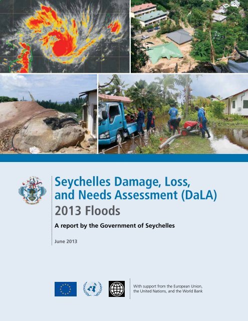
On January 27–28, 2013, heavy rains resulting from<br />
tropical cyclone Felleng caused severe flooding <strong>and</strong> l<strong>and</strong>slides<br />
in the <strong>Seychelles</strong>, particularly in three districts on the southeast<br />
coast of Mahé (Au Cap, Pointe Larue, <strong>and</strong> Cascade),<br />
as well as on the nearby isl<strong>and</strong>s of Praslin <strong>and</strong> La Digue.
iii<br />
Foreword<br />
Tropical Storm “Felleng”’s proximity to <strong>Seychelles</strong> on the week of the 27 th January<br />
brought with it heavy rain causing severe flooding in five districts: Anse Aux<br />
Pins, Au Cap <strong>and</strong> Pointe Larue which were declared “disaster zones” <strong>and</strong> Cascade<br />
<strong>and</strong> La Digue isl<strong>and</strong> which were also significantly affected. Hundreds of households<br />
were affected, dozens of families were displaced, infrastructure was damaged<br />
beyond repair <strong>and</strong> many farms were destroyed.<br />
We are grateful that no one was killed or seriously injured from the disaster, but this<br />
event was a wakeup call for the entire nation <strong>and</strong> perhaps a reminder similar to that<br />
of the 2004 Indian Ocean tsunami that claimed the lives of three people - a reminder<br />
that <strong>Seychelles</strong> is not safe from disasters.<br />
This “<strong>Seychelles</strong> 2013 Post-Flood <strong>Damage</strong>, <strong>Loss</strong> <strong>and</strong> <strong>Needs</strong> <strong>Assessment</strong>” report is<br />
proof of <strong>Seychelles</strong>’ government’s resolve <strong>and</strong> commitment to ensure the safety <strong>and</strong><br />
well-being of our people as well as the conservation of endemic flora, fauna <strong>and</strong> the<br />
country’s other limited natural resources. The <strong>Seychelles</strong> government recognizes the<br />
necessity to continuously improve disaster risk reduction <strong>and</strong> management within our<br />
country. We are responsible for safeguarding every individual citizen <strong>and</strong> visitor to our<br />
isl<strong>and</strong> nation.<br />
This report provides a detailed breakdown of the sectors affected, economic losses<br />
<strong>and</strong> damages, <strong>and</strong> the equipment <strong>and</strong> manpower needs to rebuild better <strong>and</strong> to create<br />
legislation that incorporates disaster risk reduction <strong>and</strong> management throughout<br />
so that we continue to develop into a country that is more resilient to disasters – a<br />
disaster-resistant nation safe for all.<br />
Pierre Laporte<br />
Minister of Finance<br />
Professor Rolph Payet<br />
Minister of Environment <strong>and</strong> Energy
iv<br />
<strong>Seychelles</strong> <strong>Damage</strong>, <strong>Loss</strong> <strong>and</strong> <strong>Needs</strong> <strong>Assessment</strong> (<strong>DaLA</strong>) 2013 Floods<br />
Acknowledgments<br />
This report reflects the relief <strong>and</strong> recovery efforts of the Government of <strong>Seychelles</strong> to lift the nation out of the<br />
economic setbacks, infrastructure destruction <strong>and</strong> social impact caused by tropical storm “Felleng” which<br />
impacted Mahé isl<strong>and</strong> the week of January 27, 2013.<br />
The Government of <strong>Seychelles</strong> extends its most profound gratitude to the World Bank for having rapidly sent a<br />
team of experts to conduct a “<strong>Damage</strong>, <strong>Loss</strong> <strong>and</strong> <strong>Needs</strong> <strong>Assessment</strong>” at the request of H.E Vice President Mr.<br />
Danny Faure, in the immediate aftermath of the devastating floods.<br />
The report is a joint collaboration of Government of <strong>Seychelles</strong> <strong>and</strong> the World Bank. This report has been produced<br />
under the guidance of Honorable Pierre Laporte, Minister of Finance, Trade <strong>and</strong> Investment, Honorable Professor<br />
Rolph Payet, Minister of Environment <strong>and</strong> Energy, Louis Rene Peter Larose, World Bank Alternate Executive Director,<br />
Haleh Bridi, World Bank Country Director for Madagascar, Mauritius, Comoros <strong>and</strong> <strong>Seychelles</strong>, Jamal Saghir,<br />
Director for Sustainable Development for the Africa Region at the World Bank, <strong>and</strong> Benoit Bosquet, Sector Manager<br />
for Africa Natural Resources at the World Bank.<br />
The report has been produced by a team led Bertr<strong>and</strong> Belle (Principle Secretary, Ministry of Finance), Wills Agricole<br />
(Principle Secretary, Ministry of Environment <strong>and</strong> Energy) <strong>and</strong> a team consisting of , Elizabeth Charles (Director<br />
General, Ministry of Finance), Paul Labaleine (Director General, DRDM <strong>Seychelles</strong>), Divina Sabino (Project officer,<br />
DRDM <strong>Seychelles</strong>), supported by a World Bank team led by Jingjie Chu (Natural Resource Economist), Doekle<br />
Geert Wielinga (Sr. Disaster Risk Management Specialist), Isabelle Forge (Consultant), Ellen Tynan (Consultant),<br />
Isabelle Kane (Disaster Risk Management Specialist), Carl Christian Dingel (Disaster Risk Management Specialist),<br />
<strong>and</strong> Sawkut Rojid (Economist).<br />
The authors are grateful to Cliff Alissop, Regina Prosper <strong>and</strong> Veronique Baker from DRDM for their logistic support,<br />
Henriette B. Mampuya <strong>and</strong> Sajid Anwar from <strong>GFDRR</strong> for their invaluable comments on an earlier draft of this<br />
report <strong>and</strong> Chalida Chararnsuk from the World Bank for providing excellent administrative support in the process<br />
of the assessment <strong>and</strong> report write up.<br />
Last but certainly not least is to acknowledge with much appreciation the crucial role of all individuals from the<br />
Ministries, <strong>and</strong> development organizations such as the United Nations Development Program (UNDP), World<br />
Health Organization (WHO), the European Union (EU), <strong>and</strong> <strong>Seychelles</strong> Red Cross that have contributed their synergistic<br />
participation during the preparation of this report.<br />
The African, Caribbean <strong>and</strong> Pacific (ACP) Group of States <strong>and</strong> the European Union (EU) have provided financial<br />
support for the <strong>Damage</strong> <strong>and</strong> <strong>Loss</strong> <strong>Assessment</strong> through the Global Facility for Disaster Reduction <strong>and</strong> Recovery<br />
(<strong>GFDRR</strong>), in the framework of the ACP-EU Natural Disaster Risk Reduction Program.
v<br />
Table of Contents<br />
Foreword....................................................................................................................................................... iii<br />
Acknowledgments.................................................................................................................................... iv<br />
Abbreviations.............................................................................................................................................. viii<br />
Executive Summary................................................................................................................................... xi<br />
Chapter 1: Country Overview.............................................................................................................. 1<br />
1.1 <strong>Seychelles</strong>’ Vulnerability to Natural Hazards <strong>and</strong> Climate Change............................................................ 1<br />
1.2 Overview of the Disaster......................................................................................................................... 2<br />
1.3 The Immediate Response........................................................................................................................ 2<br />
Chapter 2: Economic <strong>and</strong> Sector Impacts <strong>and</strong> <strong>Needs</strong>............................................................... 5<br />
2.1 <strong>Assessment</strong> Preparation.......................................................................................................................... 5<br />
2.1.1 Training........................................................................................................................................ 5<br />
2.1.2 <strong>Assessment</strong> Methodology............................................................................................................. 6<br />
2.2 <strong>Assessment</strong> by Sectors............................................................................................................................ 7<br />
2.2.1 Infrastructure................................................................................................................................ 7<br />
2.2.2 Productive Sectors........................................................................................................................ 18<br />
2.2.3 Social Sectors............................................................................................................................... 21<br />
2.2.4 Cross-Cutting Sectors................................................................................................................... 28<br />
2.3 Macroeconomic Impact........................................................................................................................... 36<br />
2.3.1 Macroeconomic Impact................................................................................................................ 36<br />
2.3.2 Personal/Household Impact.......................................................................................................... 37<br />
Chapter 3: Conclusion <strong>and</strong> Recommendations........................................................................... 39<br />
3.1 <strong>Damage</strong> <strong>and</strong> <strong>Loss</strong> Summary.................................................................................................................... 39<br />
3.2 Recovery <strong>and</strong> Reconstruction Summary................................................................................................... 39<br />
3.3 <strong>Seychelles</strong> Disaster Resilience Framework................................................................................................ 41<br />
Appendix 1. Satellite Image of St<strong>and</strong>ing Water after the Flood....................................................................... 46<br />
Appendix 2. <strong>DaLA</strong> Training Attendee List....................................................................................................... 47<br />
Appendix 3. <strong>Seychelles</strong>’ Vulnerability to Climate Change............................................................................... 48<br />
Appendix 4. <strong>Damage</strong>s <strong>and</strong> <strong>Loss</strong>es for Police Services...................................................................................... 51
vi<br />
<strong>Seychelles</strong> <strong>Damage</strong>, <strong>Loss</strong> <strong>and</strong> <strong>Needs</strong> <strong>Assessment</strong> (<strong>DaLA</strong>) 2013 Floods<br />
Appendix 5. Detailed Calculation of <strong>Needs</strong> for the Education Sector.............................................................. 52<br />
Appendix 6. DRDM Personnel Status............................................................................................................. 53<br />
Appendix 7. Detailed Expenses for DRDM...................................................................................................... 54<br />
Appendix 8. Development Policy Loan with a Catastrophe Deferred Drawdown Option (CAT DDO)............... 55<br />
LIST OF TABLES<br />
Table 2.1 Estimated <strong>Damage</strong> <strong>and</strong> <strong>Loss</strong>es for the Transport/Road Sector..................................................... 8<br />
Table 2.2 Estimated Recovery <strong>and</strong> Reconstruction <strong>Needs</strong> for the Transport/Road Sector............................. 9<br />
Table 2.3 Estimated <strong>Damage</strong>s <strong>and</strong> <strong>Loss</strong>es for the Water <strong>and</strong> Sewerage Sector........................................... 11<br />
Table 2.4 Estimated Recovery <strong>and</strong> Reconstruction <strong>Needs</strong> for the Water <strong>and</strong> Sanitation Sector.................... 13<br />
Table 2.5 Estimated <strong>Damage</strong>s <strong>and</strong> <strong>Loss</strong>es for the Electricity Sector............................................................. 14<br />
Table 2.6 Estimated Reconstruction <strong>Needs</strong> for the Electricity Sector........................................................... 14<br />
Table 2.7 Estimated <strong>Damage</strong>s <strong>and</strong> <strong>Loss</strong>es for the SFRSA............................................................................ 15<br />
Table 2.8 Estimated Recovery <strong>and</strong> Reconstruction <strong>Needs</strong> for the SFRSA..................................................... 15<br />
Table 2.9 Estimated <strong>Damage</strong>s <strong>and</strong> <strong>Loss</strong>es for the Police Department......................................................... 15<br />
Table 2.10 Estimated Recovery <strong>and</strong> Reconstruction <strong>Needs</strong> for the Police Department.................................. 16<br />
Table 2.11 Estimated <strong>Damage</strong> <strong>and</strong> <strong>Loss</strong>es within SPDF................................................................................ 16<br />
Table 2.12 Estimated <strong>Damage</strong> <strong>and</strong> <strong>Loss</strong>es within the SCAA......................................................................... 16<br />
Table 2.13 Estimated Cost of Recovery <strong>and</strong> Reconstruction <strong>Needs</strong> within the SCAA (Aviation Sector).......... 17<br />
Table 2.14 Summary of <strong>Damage</strong> <strong>and</strong> <strong>Loss</strong>es from the Agriculture Sector..................................................... 19<br />
Table 2.15 Summary of <strong>Needs</strong> for the Agriculture Sector............................................................................. 19<br />
Table 2.16 Property Value <strong>Loss</strong> Due to L<strong>and</strong>slides........................................................................................ 20<br />
Table 2.17 <strong>Damage</strong>s to Agro Industries due to the Flood............................................................................. 21<br />
Table 2.18 Estimated <strong>Damage</strong>s <strong>and</strong> <strong>Loss</strong>es for the Housing Sector.............................................................. 23<br />
Table 2.19 Summary <strong>Needs</strong> for the Housing Sector..................................................................................... 24<br />
Table 2.20 Number of Schools <strong>and</strong> Students in the <strong>Seychelles</strong>, 2012........................................................... 25<br />
Table 2.21 <strong>Damage</strong> <strong>and</strong> <strong>Loss</strong> Estimates for the Education Sector................................................................. 25<br />
Table 2.22 <strong>Needs</strong> Estimates for the Education Sector................................................................................... 26<br />
Table 2.23 Cost for Construction of a New School for Pointe Larue Secondary............................................ 26<br />
Table 2.24 Disaster Risks That Schools Are Facing........................................................................................ 27<br />
Table 2.25 Estimated <strong>Damage</strong> <strong>and</strong> <strong>Loss</strong>es in the Health Sector.................................................................... 27<br />
Table 2.26 <strong>Needs</strong> Estimation for a Suspected Dengue Epidemic Contingency Response Plan....................... 28<br />
Table 2.27 Estimation of <strong>Damage</strong> <strong>and</strong> <strong>Loss</strong>es for the Environment Sector.................................................... 29<br />
Table 2.28 Proportion of Female-Headed Households by District................................................................. 31<br />
Table 2.29 Expenses Incurred by DRDM during the Flood............................................................................ 34<br />
Table 2.30 <strong>Needs</strong> for DRDM........................................................................................................................ 35
TABLE OF CONTENTS<br />
vii<br />
Table 2.31 Summary of Endorsed, Completed, <strong>and</strong> Ongoing Policies Related to Disaster Risk Management. 36<br />
Table 2.32 Expenditure for ASP................................................................................................................... 36<br />
Table 2.33 Estimation of Income <strong>Loss</strong> Due to Disease.................................................................................. 37<br />
Table 2.34 Estimation of Income <strong>Loss</strong> due to Effects of Flood (Women)....................................................... 37<br />
Table 3.1 Summary of <strong>Damage</strong>s <strong>and</strong> <strong>Loss</strong>es for All Sectors........................................................................ 40<br />
Table 3.2 Summary of Recovery <strong>and</strong> Reconstruction <strong>Needs</strong> for the <strong>Seychelles</strong>............................................ 42<br />
Table 3.3 Total <strong>Damage</strong>s, <strong>Loss</strong>es, <strong>and</strong> <strong>Needs</strong>............................................................................................. 42<br />
List of Figures<br />
Figure 1.1 Flood Impact on the <strong>Seychelles</strong>.................................................................................................. 17<br />
Figure 1.2 <strong>Seychelles</strong> Maximum Three-Day Consecutive Totals for January between 1972 <strong>and</strong> 2013........... 18<br />
Figure 2.1 Number of Houses Affect by Flood, by District........................................................................... 22<br />
Figure 3.1 <strong>Damage</strong> <strong>and</strong> <strong>Loss</strong>es................................................................................................................... 39<br />
Figure 3.2 Summary of the Total <strong>Damage</strong> <strong>and</strong> <strong>Loss</strong>es by Groups................................................................. 39<br />
Figure 3.3 Summary of Total <strong>Damage</strong> <strong>and</strong> <strong>Loss</strong>es by Ownership................................................................. 41<br />
Figure A3.1 Satellite Imagery: Active clouds associated wit Tropical Cyclone Felleng Affecting Mahé<br />
<strong>and</strong> some of the Inner Isl<strong>and</strong>s on January 28, 2013 ................................................................... 48<br />
Figure A3.2 Time Series of Pointe Larue Monthly Observed Sea-Level Anomaly............................................. 49<br />
Figure A3.3 Time Series of Mahé Isl<strong>and</strong> Monthly Sea-Level Anomaly............................................................. 5-
viii<br />
<strong>Seychelles</strong> <strong>Damage</strong>, <strong>Loss</strong> <strong>and</strong> <strong>Needs</strong> <strong>Assessment</strong> (<strong>DaLA</strong>) 2013 Floods<br />
Abbreviations<br />
ACP<br />
ASP<br />
AWS<br />
BBB<br />
CPS<br />
<strong>DaLA</strong><br />
DMP<br />
DRDM<br />
EEZ<br />
GDP<br />
<strong>GFDRR</strong><br />
HFC<br />
IBRD<br />
LWMA<br />
MCDSAS<br />
MDGs<br />
MEE<br />
MFA<br />
MLUH<br />
MNRI<br />
MoE<br />
MoF<br />
MoH<br />
NBS<br />
NCD<br />
NDC<br />
NDRF<br />
NDRP<br />
NDS<br />
NEOC<br />
NFTF<br />
NHSF<br />
PMC<br />
PUC<br />
RAHSPS<br />
African, Caribbean <strong>and</strong> Pacific<br />
Agency for Social Protection<br />
automatic weather stations<br />
build back better<br />
Civil Protection Section<br />
<strong>Damage</strong> <strong>and</strong> <strong>Loss</strong> <strong>Assessment</strong><br />
drainage master plan<br />
Division of Risk <strong>and</strong> Disaster Management<br />
exclusive economic zone<br />
gross domestic product<br />
Global Facility for Disaster Reduction <strong>and</strong> Recovery<br />
Housing Finance Company<br />
International Bank for Reconstruction <strong>and</strong> Development<br />
L<strong>and</strong>scape <strong>and</strong> Waste Management Agency<br />
Ministry of Community Development, Social Affairs, <strong>and</strong> Sports<br />
Millennium Development Goals<br />
Ministry of Environment <strong>and</strong> Energy<br />
Ministry of Foreign Affairs<br />
Ministry of L<strong>and</strong> Use <strong>and</strong> Habitat<br />
Ministry of Natural Resources <strong>and</strong> Industry<br />
Ministry of Education<br />
Ministry of Finance<br />
Ministry of Health<br />
National Bureau of Statistics<br />
noncommunicable disease<br />
National Disaster Committee<br />
National Disaster Relief Fund<br />
National Disaster Response Plan<br />
National Disaster Secretariat<br />
National Emergency Operations Center<br />
National Flood Task Force<br />
National Health Strategic Framework<br />
Property Management Company<br />
Public Utilities Corporation<br />
Risk <strong>Assessment</strong>, Hazard Surveillance, <strong>and</strong> Prevention Section
ABBREVIATIONS<br />
ix<br />
RBC<br />
RSMC<br />
RSPS<br />
SAA<br />
SACOS<br />
SCAA<br />
SFRSA<br />
SIA<br />
SLTA<br />
SNMS<br />
SOP<br />
SPDF<br />
SR<br />
TEAS<br />
UNDP<br />
VEOC<br />
WHO<br />
rotating biological contactor<br />
Regional Specialized Meteorological Centre<br />
Research <strong>and</strong> Special Projects Section<br />
<strong>Seychelles</strong> Agriculture Agency<br />
State Assurance Corporation of <strong>Seychelles</strong><br />
<strong>Seychelles</strong> Civil Aviation Authority<br />
<strong>Seychelles</strong> Fire <strong>and</strong> Rescue Services Agency<br />
<strong>Seychelles</strong> International Airport<br />
<strong>Seychelles</strong> L<strong>and</strong> Transport Agency<br />
<strong>Seychelles</strong> National Meteorological Services<br />
st<strong>and</strong>ard operating procedure<br />
<strong>Seychelles</strong> People’s Defense Forces<br />
<strong>Seychelles</strong> rupee<br />
Training, Education, <strong>and</strong> Awareness Section<br />
United Nations Development Programme<br />
Virtual Emergency Operations Center<br />
World Health Organization
On January 27–28, 2013, heavy rains resulting from<br />
tropical cyclone Felleng caused severe flooding <strong>and</strong> l<strong>and</strong>slides<br />
in the <strong>Seychelles</strong>, particularly in three districts on the southeast<br />
coast of Mahé (Au Cap, Pointe Larue, <strong>and</strong> Cascade),<br />
as well as on the nearby isl<strong>and</strong>s of Praslin <strong>and</strong> La Digue.
xi<br />
Executive Summary<br />
Overview<br />
On January 27–28, 2013, heavy rains resulting from tropical cyclone Felleng caused<br />
severe flooding <strong>and</strong> l<strong>and</strong>slides in the <strong>Seychelles</strong>, particularly in three districts on the<br />
southeast coast of Mahé (Au Cap, Pointe Larue, <strong>and</strong> Cascade), as well as on the<br />
nearby isl<strong>and</strong>s of Praslin <strong>and</strong> La Digue. The rainfall, which represented 66% of the<br />
long-term average <strong>and</strong> was coming after heavier than normal rains for the month of<br />
January, overwhelmed existing natural <strong>and</strong> constructed drainage systems <strong>and</strong> retaining<br />
walls, causing floods, l<strong>and</strong>slides, <strong>and</strong> rockfalls, <strong>and</strong> resulting in serious damage to<br />
homes <strong>and</strong> public buildings, roads, bridges, drainage systems, water <strong>and</strong> sanitation<br />
systems, crops, <strong>and</strong> farms.<br />
The isl<strong>and</strong>s of the archipelago of the <strong>Seychelles</strong> are generally low-lying (2–6 meters<br />
above sea level on average), with the topography of Mahé dominated by a central<br />
mountainous ridge with steep slopes on both sides running down to a narrow coastal<br />
plateau. Consequently, infrastructure on Mahé, as well as on Praslin <strong>and</strong> La Digue,<br />
is concentrated on the lower slopes <strong>and</strong> coastal plateau. These patterns of development,<br />
along with the geomorphology of the isl<strong>and</strong>s <strong>and</strong> their location, make the isl<strong>and</strong>s<br />
vulnerable to a variety of natural hazards, including the flooding <strong>and</strong> l<strong>and</strong>slides<br />
that impacted the country in late January.<br />
The government responded rapidly to both the threat <strong>and</strong> the results of the heavy<br />
rains in January, issuing the first warning to the public on January 25, 2013. The<br />
government declared the three hardest-hit districts disaster zones, opened the<br />
Emergency Operations Center, <strong>and</strong> mobilized emergency first responders. Relief<br />
efforts were also generally well executed, with displaced individuals housed rapidly<br />
<strong>and</strong> key infrastructure (major drains <strong>and</strong> roads) on Mahé <strong>and</strong> La Digue pumped <strong>and</strong><br />
cleared within days of the floods. President James Michel called an extraordinary<br />
Cabinet session in response to the floods, <strong>and</strong> quickly instituted a National Flood<br />
Task Force (NFTF), a high-level coordination body to ensure the effective <strong>and</strong> efficient<br />
response for the postflood needs. In addition, a National Disaster Relief Fund<br />
(NDRF) was established to assist with relief <strong>and</strong> recovery operations (over US$3.1<br />
million has been raised to date). The NFTF is the approving <strong>and</strong> management body<br />
for the relief fund.<br />
Flood Impact Summary<br />
The impact of the flooding <strong>and</strong> l<strong>and</strong>slides was exacerbated due to the combination<br />
of both natural <strong>and</strong> anthropogenic causes. The greater than average rains had resulted<br />
in heavily saturated soils, but vulnerability was also increased due to a pattern
xii<br />
<strong>Seychelles</strong> <strong>Damage</strong>, <strong>Loss</strong> <strong>and</strong> <strong>Needs</strong> <strong>Assessment</strong> (<strong>DaLA</strong>) 2013 Floods<br />
of noncompliance with existing building <strong>and</strong> l<strong>and</strong> use<br />
regulations, resulting in, inter alia, increased siltation of<br />
natural drainage, increased runoff, <strong>and</strong> poorly sited construction.<br />
Utilizing the <strong>Damage</strong> <strong>and</strong> <strong>Loss</strong> <strong>Assessment</strong> (<strong>DaLA</strong>)<br />
methodology (after receiving training from the World<br />
Bank team), the various government departments involved<br />
have been able to aggregate key data <strong>and</strong> underst<strong>and</strong><br />
the full impact of the flood in terms of both<br />
damages (impact on physical infrastructure) <strong>and</strong> losses<br />
(economic impact). Data gathering <strong>and</strong> analysis of flood<br />
impact were conducted for the following overarching<br />
sectors: (i) infrastructure—transport/roads, electricity,<br />
water supply <strong>and</strong> sanitation, <strong>and</strong> fire, police, <strong>and</strong> aviation;<br />
(ii) productive—agriculture <strong>and</strong> agro-industries;<br />
(iii) social—housing, health, <strong>and</strong> education; <strong>and</strong> (iv)<br />
cross-cutting—environment, gender, <strong>and</strong> disaster risk<br />
management. An analysis of the macroeconomic impact<br />
of the event was carried out as well.<br />
According to the summary of the data reported from<br />
each affected sector, the January 2013 disaster in the<br />
<strong>Seychelles</strong> resulted in total damage <strong>and</strong> losses of SR<br />
Figure 1: Summary of the data reported from<br />
each affected sector (million SR)<br />
104 million (US$8.4 million), equivalent to 0.77% of<br />
the country’s gross domestic product (GDP). Most of<br />
the flood damage was sustained by the infrastructure<br />
sector (38%), followed by the productive sector<br />
(26%), the social sectors (24%), the cross-cutting sectors<br />
(5%), the fiscal budget (4%), <strong>and</strong> personal income<br />
(3%) (see Figure 1).<br />
As is to be expected, the proportion of damage versus<br />
losses is greatest in the infrastructure sector <strong>and</strong> about<br />
equal in the productive <strong>and</strong> social sectors. The proportion<br />
of losses versus damage was greatest in the area<br />
of personal income, the environment sector, <strong>and</strong> other<br />
line ministries (see Figure 2).<br />
Given the heavy impact on infrastructure, the public<br />
sector bore the brunt of the disaster with 70% of damage<br />
<strong>and</strong> losses, versus 30% for the private sector.<br />
The following table summarizes the damage <strong>and</strong> losses<br />
for all affected sectors:<br />
Among the subsectors, the transport/roads subsector<br />
was the most affected (35.1%), followed by agricul-<br />
Figure 2: proportion of losses versus damage<br />
40<br />
Cross-cutting<br />
5,084,414<br />
5%<br />
Social sectors<br />
25,426,880<br />
24%<br />
Fiscal budget<br />
4,351,567<br />
4%<br />
Personal income<br />
2,506,586<br />
3%<br />
Infrasructure<br />
39,592,391<br />
38%<br />
Million SR<br />
30<br />
20<br />
n <strong>Loss</strong><br />
n <strong>Damage</strong><br />
Productive<br />
sectors<br />
27,532,008<br />
26%<br />
10<br />
0<br />
Infrasructure<br />
Productive<br />
Social sector<br />
Cross-cutting<br />
Fiscal budget<br />
Personal income
EXECUTIVE SUMMARY<br />
xiii<br />
Subsector, component<br />
Disaster effects (SR)<br />
Disaster effects (US$)<br />
<strong>Damage</strong> <strong>Loss</strong>es Total <strong>Damage</strong> <strong>Loss</strong>es Total<br />
Social sectors 15,231,910 10,194,970 25,426,880 1,218,553 815,598 2,034,150<br />
Housing 12,186,910 2,534,970 14,721,880 974,953 202,798 1,177,750<br />
Education 2,545,000 660,000 3,205,000 203,600 52,800 256,400<br />
Health 500,000 7,000,000 7,500,000 40,000 560,000 600,000<br />
Productive sectors 14,152,541 13,379,467 27,532,008 1,132,203 1,070,357 2,202,561<br />
Agriculture 9,706,788 8,129,467 17,836,255 776,543 650,357 1,426,900<br />
Industry 4,445,753 — 4,445,753 355,660 — 355,660<br />
L<strong>and</strong> use — 5,250,000 5,250,000 — 420,000 420,000<br />
Tourism — — — — — —<br />
Infrastructure 36,217,940 3,374,451 39,592,391 2,897,435 267,076 3,167,391<br />
Transport/roads 34,600,000 2,050,000 36,650,000 2,768,000 164,000 2,932,000<br />
Aviation 20,000 — 20,000 1,600 — 1,600<br />
Electricity 25,000 200,000 225,000 2,000 16,000 18,000<br />
Water supply/sewerage/sanitation 985,000 750,000 1,735,000 78,800 60,000 138,800<br />
Police Department 156,300 — 156,300 12,504 — 12,504<br />
People’s Defense Forces (SPDF—Army) — 36,000 36,000 — — —<br />
Fire Rescue Services Agency (SFRSA) 431,640 338,451 770,091 34,531 27,076 61,607<br />
Cross-cutting sectors — 5,084,414 5,084,414 — 406,753 406,753<br />
Disaster risk management — 620,139 620,139 — 49,611 49,611<br />
Environment — 4,464,275 4,464,275 — 357,142 357,142<br />
Personal income loss — 2,506,586 2,506,586 — 200,527 200,527<br />
Due to disease — 2,410,515 2,410,515 — 192,841 192,841<br />
Cottage business — 96,071 96,071 — 7,686 7,686<br />
Fiscal budget — 4,351,567 4,351,567 — 348,125 348,125<br />
Agency for Social Protection (ASP) — 3,271,567 3,271,567 — 261,725 261,725<br />
Ministry of L<strong>and</strong> <strong>and</strong> Housing — 480,000 480,000 — 38,400 38,400<br />
District administration — 600,000 600,000 — 48,000 48,000<br />
Total 65,602,391 38,409,888 104,493,846 5,248,191 3,108,436 8,359,508<br />
ture (17.1%), housing (14.1%), health (7.2%), l<strong>and</strong><br />
use (5%), <strong>and</strong> environment <strong>and</strong> industry (both 4.3%).<br />
The macroeconomic impact of the flood will take longer<br />
to become apparent. However, initial reports indicate<br />
that the immediate fiscal impact of the disaster<br />
was approximately SR 4 million (0.03 percent of GDP<br />
or 0.08 of the recurrent budget). The increased expenditures<br />
were accommodated by making use of the<br />
government’s budget framework, as no allocation with<br />
respect to natural calamities was made to the budgeted<br />
contingency fund of SR 50 million.<br />
Initial government expenditures included first assistance<br />
to the neediest individuals <strong>and</strong> families by the Agency<br />
for Social Protection (ASP); emergency assistance provided<br />
by the Ministry of L<strong>and</strong> <strong>and</strong> Housing (MLUH) <strong>and</strong><br />
the <strong>Seychelles</strong> L<strong>and</strong> <strong>and</strong> Transport Authority (SLTA); <strong>and</strong>,<br />
at the district level, the District Administrators have incurred<br />
an expenditure of SR 0.6 million for similar activities.<br />
The total of SR 4.35 million of the fiscal budget loss<br />
has been reflected in the summary table above.<br />
While the Central Bank of <strong>Seychelles</strong> maintains its<br />
tight monetary policy, inflation rate increased by 3 ba-
xiv<br />
<strong>Seychelles</strong> <strong>Damage</strong>, <strong>Loss</strong> <strong>and</strong> <strong>Needs</strong> <strong>Assessment</strong> (<strong>DaLA</strong>) 2013 Floods<br />
sis points in February (from 5.9 in January to 6.2 in<br />
February). This is a result of an increase in price indices<br />
across the board. While this increase may be associated<br />
with the disaster, it may also be the effect of the<br />
Value Added Tax system introduced in January 2013.<br />
While merch<strong>and</strong>ise trade cannot be measured due to<br />
limited information, tourism seems to be unaffected,<br />
with tourist arrivals continuing to increase, at an average<br />
of 15 percent above the same period of 2012.<br />
Recovery <strong>and</strong> Reconstruction Priorities<br />
While the total damage <strong>and</strong> losses for the <strong>Seychelles</strong><br />
amount to SR 104 million (US$8.4 million), recovery <strong>and</strong><br />
reconstruction needs are estimated at SR 379 million<br />
(US$30.3 million) (see the table below). This estimate<br />
reflect costs for both the initial recovery <strong>and</strong> reconstruction<br />
needs, as well as the costs of “building back better”<br />
(BBB) <strong>and</strong> mainstreaming disaster risk management<br />
throughout key sectors to reduce future disaster impacts<br />
<strong>and</strong> avoid future costs. In the education sector, for example,<br />
this approach would recommend the re-siting of<br />
the Pointe Larue School to a location less vulnerable to<br />
future floods. In the transport sector, it could include<br />
acquisition of additional maintenance equipment. In<br />
disaster risk management, it could include additional<br />
investments in technology <strong>and</strong> infrastructure to ensure<br />
that essential communications <strong>and</strong> safeguarding of citizens<br />
can continue in times of disaster.<br />
Given the overall excellent <strong>and</strong> rapid response of the<br />
government to the disaster, many of the short-term<br />
recovery (<strong>and</strong> reconstruction) needs have been or are<br />
being addressed by government. For the medium- <strong>and</strong><br />
long-term needs, it will be essential for the government<br />
to take a broader view of disaster risk management for<br />
the country, including actions <strong>and</strong> budget allocations<br />
that mitigate future risk in all sectors.<br />
The calamities wrought by the January floods<br />
offer an important window of opportunity to<br />
address difficult development issues. A robust<br />
recovery <strong>and</strong> reconstruction framework is therefore<br />
proposed to provide a sequenced, prioritized, programmatic,<br />
yet flexible action plan to guide the recovery<br />
<strong>and</strong> reconstruction process that is anchored in flood<br />
risk management, based upon the following recommendations<br />
(with more explanation in the text below):<br />
<strong>Needs</strong> for recovery <strong>and</strong> reconstruction (SR)<br />
Subsector, component<br />
Recovery Reconstruction Total Available Gap<br />
Social sectors 9,998,041 160,597,654 170,595,695 — 170,595,695<br />
Housing 9,338,041 60,206,590 69,544,631 — 69,544,631<br />
Education 660,000 89,345,000 90,005,000 — 90,005,000<br />
Health — 11,803,180 11,803,180 — 11,803,180<br />
Productive sectors 8,129,467 9,708,788 17,838,255 1,909,434 15,928,821<br />
Agriculture 8,129,467 9,708,788 17,838,255 1,909,434 15,928,821<br />
Infrastructure sectors 52,457,940 117,011,000 169,468,940 — 169,468,940<br />
Transport/roads 48,600,000 42,900,000 91,500,000 — 91,500,000<br />
Aviation 20,000 706,000 726,000 — 726,000<br />
Electricity — 20,000,000 20,000,000 — 20,000,000<br />
Water supply/sewerage/sanitation 3,250,000 48,005,000 51,255,000 — 51,255,000<br />
Police Department 156,300 5,400,000 5,556,300 — 5,556,300<br />
Fire Rescue Services Agency (SFRSA) 431,640 — 431,640 — 431,640<br />
Cross-cutting sectors — — 20,214,000 18,000,000 2,214,000<br />
Division of Risk <strong>and</strong> Disaster<br />
— — 20,214,000 18,000,000 2,214,000<br />
Management (DRDM)<br />
Total (SR) 70,585,448 288,074,558 378,874,006 19,909,434 358,964,572<br />
Total (US$) 5,646,836 23,046,965 30,309,920 1,592,755 28,717,166
EXECUTIVE SUMMARY<br />
xv<br />
■■<br />
Inclusion of flood risk management into national regulations,<br />
policies, <strong>and</strong> investments for flood prevention<br />
■■<br />
Development of a risk-based national flood management<br />
strategy<br />
■■<br />
Prior assessment of flood risk <strong>and</strong> vulnerability<br />
■■<br />
Ensuring a balance between structural <strong>and</strong> nonstructural<br />
control measures<br />
■■<br />
Strengthening of institutional emergency coordination<br />
at the government <strong>and</strong> community level <strong>and</strong><br />
emergency preparedness <strong>and</strong> response<br />
■■<br />
Risk transfer <strong>and</strong> insurance mechanisms<br />
Action Plan<br />
In the body of the report, short-, medium-, <strong>and</strong> longterm<br />
recommendations are included for each sector in<br />
their respective chapters. However, the following recommendations,<br />
while not exhaustive, attempt to summarize<br />
<strong>and</strong> prioritize recommended actions based on<br />
an overall underst<strong>and</strong>ing of the impact of the floods<br />
<strong>and</strong> l<strong>and</strong>slides from the events of January 2013, as well<br />
as the need to reduce risk in the future.<br />
Short-Term Actions (1 year)<br />
■■<br />
Repair <strong>and</strong> clean up the damaged houses <strong>and</strong> infrastructure,<br />
including roads, drainages, schools, police<br />
station, <strong>and</strong> recover agriculture production<br />
■■<br />
Conduct a workshop to assess the effectiveness,<br />
efficiency, strengths, <strong>and</strong> weaknesses of the January<br />
flood response system with all the stakeholders<br />
<strong>and</strong> make improvements for the national response<br />
mechanism<br />
■■<br />
Conduct a vulnerability assessment of existing infrastructure,<br />
such as bridges, roads, channels, <strong>and</strong> solid<br />
waste management plants<br />
■■<br />
To reduce risk of flooding,<br />
• Develop or update the drainage master plan for<br />
each district for flood-prone areas<br />
• Ensure the effectiveness of operation <strong>and</strong><br />
maintenance of drainage network, as well as<br />
efficient coordination between agencies<br />
■■<br />
Develop national multirisk mapping, including flood,<br />
l<strong>and</strong>slide, rockslide, mudslide<br />
■■<br />
Develop a community emergency response plan,<br />
contingency, <strong>and</strong> evacuation toolkits, including<br />
communication strategy development <strong>and</strong> training<br />
of community-level first responders<br />
■■<br />
Conduct institutional function review related to disaster<br />
risk management<br />
■■<br />
Identify legal gaps in national flood policies <strong>and</strong> laws<br />
■■<br />
Prepare <strong>and</strong> disseminate information on cost-effective<br />
flood proofing techniques<br />
■■<br />
Review opportunities for flood risk financing<br />
Medium- to Long-Term Actions<br />
(1–5 years)<br />
■■<br />
Prepare an integrated national disaster risk management<br />
plan<br />
■■<br />
Adopt revised flood management legal framework<br />
■■<br />
Invest in essential infrastructure for maintenance of<br />
transport/roads, including an upgrade of bitumen<br />
plant(s)<br />
■■<br />
Relocate key public buildings to higher ground (e.g.,<br />
Pointe Larue School)<br />
■■<br />
Conduct an assessment of the level of integration of<br />
disaster risk measures, particularly regarding climate<br />
change adaptation, into the current sectoral plans<br />
■■<br />
Develop new risk-based building codes <strong>and</strong> strengthen<br />
training <strong>and</strong> enforcement<br />
■■<br />
Prepare floodplain l<strong>and</strong> use guidelines <strong>and</strong> laws, implement<br />
<strong>and</strong> enforce preventive l<strong>and</strong> use plans<br />
■■<br />
Mainstream disaster risk management in all sectoral<br />
management plans, particularly urban development<br />
<strong>and</strong> l<strong>and</strong> management (the current l<strong>and</strong> use zoning<br />
plan can be potentially updated after the geological<br />
risk survey is completed)<br />
■■<br />
Prepare a report on the economic evaluation of ecosystem<br />
services, particularly with regard to vulnerability<br />
related to climate change<br />
■■<br />
Identify capacity gaps <strong>and</strong> provide tailored training<br />
for staff in key ministries in disaster risk management<br />
<strong>and</strong> response<br />
■■<br />
Establish additional meteorological stations outside<br />
the flood-prone area<br />
■■<br />
Strengthen disaster monitoring <strong>and</strong> early warning<br />
systems<br />
■■<br />
Raise awareness of flood risks <strong>and</strong> vulnerabilities<br />
■■<br />
Implement risk financing mechanisms with incentives<br />
for compliance with flood control
The <strong>Seychelles</strong>’ location, topography, <strong>and</strong> l<strong>and</strong>scape make the country<br />
vulnerable to a range of natural hazards, including tropical cyclones,<br />
tsunamis, storm surge, extreme rainfall, flooding, l<strong>and</strong>slides, rockslides,<br />
<strong>and</strong> forest fires—most of which are likely to be exacerbated<br />
by the effects of climate change.
1<br />
CHAPTER 1: Country Overview<br />
1.1 <strong>Seychelles</strong>’ Vulnerability to Natural Hazards <strong>and</strong> Climate<br />
Change<br />
The <strong>Seychelles</strong> archipelago comprises 115 isl<strong>and</strong>s extending over approximately 1,374<br />
square kilometers (including its exclusive economic zone [EEZ]) in the Indian Ocean<br />
between 4 <strong>and</strong> 9 degrees south of the equator <strong>and</strong> about 1500 km east of mainl<strong>and</strong><br />
Africa. Over 85% of the country’s population (87,400) resides on Mahé, the largest<br />
isl<strong>and</strong> in the country (148 sq. km), with most of the remaining population residing on<br />
the isl<strong>and</strong>s of Praslin <strong>and</strong> La Digue, both of which lie less than 45 km from Mahé. The<br />
topography of Mahé consists of a central mountainous ridge with steep slopes on both<br />
sides running down to a narrow coastal plateau. On Mahé, Praslin, <strong>and</strong> La Digue, most<br />
development, including tourism, transport, <strong>and</strong> housing, is located in the plateau area.<br />
The isl<strong>and</strong>s are generally low-lying with an average of 2–6 m above sea level.<br />
The <strong>Seychelles</strong>’ location, topography, <strong>and</strong> l<strong>and</strong>scape make the country vulnerable to a<br />
range of natural hazards, including tropical cyclones, tsunamis, storm surge, extreme<br />
rainfall, flooding, l<strong>and</strong>slides, rockslides, <strong>and</strong> forest fires—most of which are likely to<br />
be exacerbated by the effects of climate change. The country is tectonically inactive,<br />
so earthquake is not seen as a risk. No seismic activity has been recorded since the installation<br />
of the country’s seismological station in 1995. The adverse effects of climate<br />
change <strong>and</strong> sea-level rise present significant risks to the sustainable development of<br />
the <strong>Seychelles</strong>. Vulnerability characteristics such as the concentration of development<br />
on the narrow coastal zones, vulnerable populations, <strong>and</strong> ecosystems make the <strong>Seychelles</strong><br />
extremely sensitive to climate change <strong>and</strong> its associated impacts. The impact<br />
of climate change as a result of sea-level rise, storm <strong>and</strong> tidal surges, <strong>and</strong> changes in<br />
rainfall patterns as well as increased coral bleaching events are likely to have serious<br />
consequences to livelihoods in the long term. The effects of climate change on tourism<br />
are expected to be largely negative. Adaptation to adverse impacts of climate<br />
change <strong>and</strong> sea-level rise remains a major priority for the <strong>Seychelles</strong>.<br />
The main issues relating to climate change are the following:<br />
■■<br />
More extreme weather events. Although the <strong>Seychelles</strong> has been relatively protected<br />
from tropical cyclones due to its location, some trends indicate the possibility that<br />
the cyclone belt <strong>and</strong> risk area is widening in the Indian Ocean, potentially putting<br />
the <strong>Seychelles</strong>’ region in a more favorable position for cyclonic development. Data<br />
also shows that for the majority of the El Niño/La Niña cases, an extreme weather<br />
event occurred over the <strong>Seychelles</strong>. With global warming, El Niño may collude with<br />
the Indian Ocean Dipole <strong>and</strong> other phenomena to cause extreme impacts.<br />
■■<br />
Sea-level rise. Major economic activities, development, <strong>and</strong> infrastructure located<br />
along the coastal plains <strong>and</strong> reclaimed l<strong>and</strong> makes the <strong>Seychelles</strong> highly vulnerable<br />
to sea-level rise; this will have serious consequences to livelihoods as a result of<br />
coastal erosion <strong>and</strong> flooding.
2<br />
<strong>Seychelles</strong> <strong>Damage</strong>, <strong>Loss</strong> <strong>and</strong> <strong>Needs</strong> <strong>Assessment</strong> (<strong>DaLA</strong>) 2013 Floods<br />
■■<br />
Changes in rainfall pattern/distribution. It is<br />
important to note that although the <strong>Seychelles</strong><br />
received excessive rains during the rainy season,<br />
water scarcity remains one of the most significant<br />
challenges for the country, which experienced low<br />
rainfall in the previous dry season. Climate change<br />
scenarios for the <strong>Seychelles</strong> indicate that rainy<br />
seasons are like to become wetter <strong>and</strong> dry seasons<br />
drier. The country is already experiencing a change<br />
in rainfall distribution—from more moderate rainfall<br />
over a two-to-three-day period to heavy, short-lived<br />
rainfall. This latter pattern is capable of causing flash<br />
floods over low-lying areas, yet is not sufficient (nor<br />
steady enough) for the best natural irrigation for<br />
agriculture or for water supply needs.<br />
■■<br />
Coastal inundation <strong>and</strong> erosion: Studies have shown<br />
that the country is already experiencing impacts due<br />
to both natural disturbance <strong>and</strong> human activities,<br />
<strong>and</strong> with climate change <strong>and</strong> sea-level rise the<br />
damages will not only increase, but will also become<br />
more severe.<br />
1.2 Overview of the Disaster<br />
On January 25, 2013, the <strong>Seychelles</strong> National Meteorological<br />
Services (SNMS) reported that the <strong>Seychelles</strong><br />
would be within the coverage area of active clouds associated<br />
with tropical depression Felleng from Monday,<br />
January 28 to Tuesday, January 29. The SNMS made<br />
a presentation to the National Disaster Committee<br />
(NDC) members, including different outcome models<br />
for the hazardous weather. In addition, the public was<br />
informed of the upcoming weather by SNMS <strong>and</strong> Division<br />
of Risk <strong>and</strong> Disaster Management (DRDM) through<br />
the local media. The hazardous weather began a day<br />
earlier than expected <strong>and</strong> the tropical depression was<br />
already causing damage by the time the first bulletin<br />
was issued by the Regional Specialized Meteorological<br />
Centre (RSMC) La Reunion/Météo-France on the morning<br />
of January 27.<br />
Total rainfall recorded for January 27 <strong>and</strong> 28 amounted<br />
to 263 mm, representing 66% of the long-term average<br />
of 400 mm per month. Three districts on the<br />
southeast coast of Mahé (Au Cap, Pointe Larue, <strong>and</strong><br />
Cascade) were declared disaster zones due to serious<br />
damages to houses, roads, bridges, the drainage<br />
system, <strong>and</strong> farms caused by flood, l<strong>and</strong>slides, <strong>and</strong><br />
rockslides. Due to the fact that the rainfall was above<br />
normal, other districts of Mahé, as well as Praslin <strong>and</strong><br />
La Digue, were also affected (figure 1.1).<br />
Multiple causes potentially led to the January disaster.<br />
Firstly, the records show that rainfall for January<br />
2013 hit a historical high, with a total amount of 871<br />
mm—twice as much as the monthly average of 400<br />
mm. Secondly, the three consecutive days of January<br />
26–28, 2013 (during tropical depression Felleng), had<br />
the highest rainfall ever recorded, over 330 mm, significantly<br />
higher than the other maximum three-day<br />
rainfall (figure 1.2).<br />
Thirdly, the rains coincided with a high tide, which did<br />
not allow drainage canals to deposit floodwater from<br />
the plains into the sea. The poor state of some existing<br />
drainage facilities also contributed to the floods, as did<br />
the high saturation levels of the soil due to earlier rains<br />
in the weeks preceding the tropical depression.<br />
Based on a preliminary UN satellite image analysis, by<br />
February 16, 2013, there were still 28 separate st<strong>and</strong>ing<br />
water bodies, totaling 41,025 square meters <strong>and</strong> averaging<br />
1,465 square meters in size (see appendix 1).<br />
1.3 The Immediate Response<br />
Advisories <strong>and</strong> Warnings. The Early Warning Center<br />
at the <strong>Seychelles</strong> National Meteorological Service<br />
(SNMS) issued nine advisories <strong>and</strong> warnings during the<br />
disaster to warn people of the ongoing heavy rains<br />
<strong>and</strong> of locations that were considered dangerous.<br />
Members of the public were advised to remain in their<br />
homes <strong>and</strong> refrain from making any trips except those<br />
that were essential, in order to avoid unnecessary road<br />
blockage or accidents that could have hampered the<br />
assistance being provided by the Emergency Services.<br />
Members of the public were also advised to use the La<br />
Misere route due to congestion on the east coast road.<br />
Additional staff <strong>and</strong> volunteers were mobilized to assess<br />
cases throughout Mahé, aside from the resources<br />
being given to the three districts in the east that had<br />
been most affected.
CHAPTER 1 COUNTRY OVERVIEW<br />
3<br />
Figure 1.1 Flood Impact on the <strong>Seychelles</strong><br />
Source: EID Section, MEE, February 2013.<br />
Figure 1.2 <strong>Seychelles</strong> Maximum Three-Day Consecutive Totals for January between 1972 <strong>and</strong> 2013<br />
350<br />
325<br />
300<br />
275<br />
250<br />
Amount in mm<br />
225<br />
200<br />
175<br />
150<br />
125<br />
100<br />
75<br />
50<br />
25<br />
0<br />
1972<br />
1973<br />
1974<br />
1975<br />
1976<br />
1977<br />
1978<br />
1979<br />
1980<br />
1981<br />
1982<br />
1983<br />
1984<br />
1985<br />
1986<br />
1987<br />
1988<br />
1989<br />
1990<br />
1991<br />
1992<br />
1993<br />
1994<br />
1995<br />
1996<br />
1997<br />
1998<br />
1999<br />
2000<br />
2001<br />
2002<br />
2003<br />
2004<br />
2005<br />
2006<br />
2007<br />
2008<br />
2009<br />
2010<br />
2011<br />
2012<br />
2013<br />
Source: Meteorological Services 2013.
4<br />
<strong>Seychelles</strong> <strong>Damage</strong>, <strong>Loss</strong> <strong>and</strong> <strong>Needs</strong> <strong>Assessment</strong> (<strong>DaLA</strong>) 2013 Floods<br />
National Flood Task Force (NFTF). President James<br />
Michel convened an extraordinary Cabinet meeting to<br />
review the situation on the ground. He informed the<br />
Cabinet of Ministers that the situation warranted establishing<br />
a National Flood Task Force (NFTF) to enable<br />
high-level coordination among ministries <strong>and</strong> agencies<br />
<strong>and</strong> to mitigate the impact of any possible secondary<br />
disasters. It is also the approving <strong>and</strong> management<br />
body for the National Disaster Relief Fund (NDRF). With<br />
the high-level involvement, it was designed to be effective<br />
<strong>and</strong> efficient. The task force was composed of:<br />
■■<br />
Mr. Vincent Meriton, the designated Minister,<br />
also the Minister of Social Affairs, Community<br />
Development, <strong>and</strong> Sport;<br />
■■<br />
Professor Rolph Payet, Minister of Environment <strong>and</strong><br />
Energy;<br />
■■<br />
Mr. Christian Lionnet, Minister of L<strong>and</strong> Use <strong>and</strong><br />
Habitat;<br />
■■<br />
Mr. Denis Rose, the Principal Secretary for Community<br />
Development;<br />
■■<br />
Mr. Steve Fanny, Permanent Secretary, Ministry of<br />
Finance;<br />
■■<br />
Ms. Marie-Antoinette Rose, head of government<br />
business in the National Assembly;<br />
■■<br />
Mr. Parinda Herath, the chief executive of the<br />
<strong>Seychelles</strong> L<strong>and</strong> Transport Agency;<br />
■■<br />
Mr. Marc Naiken, chief executive officer (CEO) of the<br />
<strong>Seychelles</strong> Agriculture Agency; <strong>and</strong><br />
■■<br />
Representatives of the Red Cross, Public Heath, <strong>and</strong><br />
Ministry of Foreign Affairs.<br />
National Disaster Relief Fund (NDRF). President<br />
James Michel also set up a National Disaster Relief<br />
Fund (NDRF) in order to raise funds both locally <strong>and</strong><br />
internationally (for both monetary <strong>and</strong> in-kind contributions)<br />
for the families who were left without a home<br />
during the floods, those who will need to repair their<br />
homes, as well as for the surrounding infrastructure.<br />
A transparent procedure was established <strong>and</strong> is being<br />
implemented by the Fund such that all donations<br />
can be reviewed online (http://www.egov.sc/ndrf/).<br />
By March 8, 2013, a total amount of SR 39,640,403<br />
(US$3,171,242) had been raised. The Fund is being utilized<br />
for disaster recovery <strong>and</strong> reconstruction.<br />
National Emergency Operations Center (NEOC).<br />
The NEOC was activated with all staff called in to<br />
DRDM. Calls received during the disaster effectively<br />
overloaded the DRDM lines. To address this, hotline<br />
numbers were increased from 2 to 4 for public calls<br />
<strong>and</strong> to 10 lines for key first responders, <strong>and</strong> private <strong>and</strong><br />
parastatal sectors. A total of 14 fixed phone numbers<br />
were used throughout the disaster. To help with data<br />
collection <strong>and</strong> phone logging, the Ministry of Environment’s<br />
various departments sent staff members they<br />
could spare to h<strong>and</strong>le calls. (All staff involved in the<br />
disaster was on call <strong>and</strong> had st<strong>and</strong>ard governmentissued<br />
mobile numbers paid under the budget of their<br />
departments/divisions.)<br />
However, there were not enough staff in the Ministry<br />
to take up all the required posts. Therefore, available<br />
staff had to work over the maximum allowed compulsory<br />
working hours of 12 hours per shift. During the<br />
disaster, most staff also had fewer than 4 hours off<br />
between shifts. Government’s response to the disaster,<br />
including that of DRDM <strong>and</strong> the emergency services<br />
was, for the most part, rapid <strong>and</strong> effective. n
5<br />
CHAPTER 2: Economic <strong>and</strong><br />
Sector Impacts <strong>and</strong> <strong>Needs</strong><br />
2.1 <strong>Assessment</strong> Preparation<br />
After the disaster of January 27–29, the government conducted an initial assessment<br />
of damages totaling approximately US$9.3 million. This early assessment of needs<br />
pointed to resources needed for the rehabilitation of infrastructure, houses, schools<br />
<strong>and</strong> other public buildings, as well as for support in the water <strong>and</strong> sanitation sector<br />
<strong>and</strong> food security. In a letter to the World Bank from January 31, 2013, HE the Vice<br />
President of the <strong>Seychelles</strong> requested the World Bank to help the government on the<br />
<strong>Damage</strong> <strong>and</strong> <strong>Loss</strong> <strong>Assessment</strong> <strong>and</strong> to support reconstruction efforts in the country.<br />
In response to the government’s request, the World Bank assembled a team of experts<br />
arriving in the country on February 18, 2013, to assist the country in the formulation<br />
of a Postdisaster <strong>Needs</strong> <strong>Assessment</strong> through training <strong>and</strong> utilization of the <strong>Damage</strong><br />
<strong>and</strong> <strong>Loss</strong> <strong>Assessment</strong> (<strong>DaLA</strong>) methodology in order to calculate damages <strong>and</strong> losses,<br />
as well as the social, economic, <strong>and</strong> environmental impacts of the disaster.<br />
2.1.1 Training<br />
■■<br />
To support capacity building within the country for postdisaster needs assessment,<br />
a one-day training on the <strong>Damage</strong> <strong>and</strong> <strong>Loss</strong> <strong>Assessment</strong> (<strong>DaLA</strong>) methodology was<br />
organized following consultations with the line ministries of the most affected<br />
sectors: l<strong>and</strong> management, agriculture, transport, housing, education, health,<br />
environment, <strong>and</strong> community development (see appendix 1).<br />
The one-day workshop, held on Friday, February 22, 2013, presented the <strong>DaLA</strong><br />
methodology to the various partners. Thirty-seven participants attended the training,<br />
including officials of the ministries (the Ministries of Finance [MoF], L<strong>and</strong> Use <strong>and</strong><br />
Habitat [MLUH], Education [MoE], Health [MoH], Community Development, Social<br />
Affairs, <strong>and</strong> Sports [MCDSAS], Environment <strong>and</strong> Energy [MEE], Foreign Affairs [MFA],<br />
Natural Resources <strong>and</strong> Industry [MNRI], National Bureau of Statistics [NBS], <strong>Seychelles</strong><br />
Fire <strong>and</strong> Rescue Services Agency [SFRSA], <strong>Seychelles</strong> L<strong>and</strong> Transport Agency<br />
[SLTA], <strong>Seychelles</strong> Public Defense Force [SPDF]), representatives of the private sector,<br />
<strong>and</strong> experts from UN agencies (Public Utilities Corporation [PUC], SACOS Insurance<br />
Company, Harry Savy insurance company, United Nations Development Programme<br />
[UNDP], <strong>and</strong> World Health Organization [WHO]). Two ministers attended the opening<br />
ceremony to support the training.<br />
■■<br />
The training focused on underst<strong>and</strong>ing the <strong>DaLA</strong> methodology <strong>and</strong> exchanging<br />
information among the different stakeholders concerned with the January floods.<br />
Participants were given the opportunity to work as groups in quantifying the
6<br />
<strong>Seychelles</strong> <strong>Damage</strong>, <strong>Loss</strong> <strong>and</strong> <strong>Needs</strong> <strong>Assessment</strong> (<strong>DaLA</strong>) 2013 Floods<br />
damage <strong>and</strong> losses under three main themes: the<br />
infrastructure sector, productive sectors, <strong>and</strong> crosscutting<br />
sectors (disaster risk management, gender,<br />
<strong>and</strong> environment). Baseline data were assembled<br />
from reports <strong>and</strong> assessments provided by the<br />
principal officers from different sectors. In the final<br />
session of the training, each group presented their<br />
main findings <strong>and</strong> significant data gaps.<br />
■■<br />
The training assisted participants in distinguishing the<br />
calculation of damages from those of losses (usually<br />
economic flow), as well as in estimating the disaster<br />
impact <strong>and</strong> identifying reconstruction (corresponding<br />
to damage) <strong>and</strong> recovery (corresponding to losses)<br />
needs.<br />
2.1.2 <strong>Assessment</strong> Methodology<br />
The <strong>DaLA</strong> methodology calculates the damage <strong>and</strong><br />
losses as well as the social, economic, <strong>and</strong> environmental<br />
impacts of a disaster. The methodology was<br />
developed by the United Nations Economic Commission<br />
for Latin America <strong>and</strong> the Caribbean (UN ECLAC)<br />
in the 1970s, <strong>and</strong> has been continuously revised <strong>and</strong><br />
customized for World Bank use in different regions of<br />
the world. The <strong>DaLA</strong> provides a close approximation of<br />
damages to assets <strong>and</strong> losses to the economic flows,<br />
<strong>and</strong> summarizes total macroeconomic impacts. This<br />
constitutes the basis for evaluating the negative impact<br />
on individual <strong>and</strong> household income <strong>and</strong> on the global<br />
population welfare <strong>and</strong> for formulating a recovery <strong>and</strong><br />
reconstruction framework.<br />
The <strong>DaLA</strong> methodology uses the country’s system of national<br />
accounts <strong>and</strong> involves all macroeconomic sectors<br />
including productive (agriculture, tourism, commerce,<br />
<strong>and</strong> industries), infrastructure (transportation, electricity,<br />
communication, <strong>and</strong> water supply <strong>and</strong> sanitation),<br />
social (housing, education, <strong>and</strong> health), as well as crosscutting<br />
issues (e.g., the environment <strong>and</strong> gender).<br />
■■<br />
<strong>Damage</strong> is defined as the monetary value of fully<br />
or partially destroyed assets. It is initially assumed<br />
that assets will be replaced to the same condition—<br />
in quantity <strong>and</strong> quality—that they had prior to the<br />
disaster.<br />
■■<br />
<strong>Loss</strong>es are defined as the changes in the flows of<br />
goods <strong>and</strong> services that will not be forthcoming in<br />
the affected area until full economic recovery <strong>and</strong><br />
reconstruction has been achieved. They include<br />
production of goods <strong>and</strong> services that will not be<br />
obtained or provided, higher costs of operation<br />
<strong>and</strong> production, <strong>and</strong> the cost of the humanitarian/<br />
emergency assistance activities. <strong>Loss</strong>es are expressed<br />
in current values.<br />
Once all sectors have been assessed in terms of damage<br />
<strong>and</strong> losses, the results are aggregated to obtain<br />
the total amount of disaster effects, ensuring that no<br />
double counting or major gaps exist. The impact on<br />
postdisaster macroeconomic performance is calculated<br />
based on damage <strong>and</strong> losses <strong>and</strong> using the forecasted<br />
performance for the current year. It includes possible<br />
slowdown of gross domestic production (GDP), deterioration<br />
of the balance of payments <strong>and</strong> of fiscal<br />
sector position, as well as an increase in inflation. It<br />
also includes decline in personal or household living<br />
conditions (livelihoods <strong>and</strong> income), possible increase<br />
in costs of living, as well as poverty aggravation from<br />
the resulting losses caused by the disaster.<br />
Finally, needs can be defined for postdisaster short-,<br />
medium-, <strong>and</strong> long-term activities, such as:<br />
■■<br />
Recovery needs: estimated on the basis of the financial<br />
resources required for rehabilitation of basic services,<br />
reactivation of productive activities, or immediate<br />
reactivation of personal or household income; or<br />
■■<br />
Reconstruction needs: estimated as the requirements<br />
for financing reconstruction <strong>and</strong> replacement or<br />
repairing of the physical assets that were destroyed<br />
by the disaster.<br />
In the recovery/reconstruction plan, these figures also<br />
include a BBB strategy to consider quality improvements<br />
<strong>and</strong> disaster risk reduction measures to be implemented<br />
in order to increase resilience against future<br />
disasters.<br />
All the following calculations are based on the exchange<br />
rate of 1 SR = US$0.08 based on February 26,<br />
2013, rates.
CHAPTER 2 Economic <strong>and</strong> Sector Impacts <strong>and</strong> <strong>Needs</strong><br />
7<br />
2.2 <strong>Assessment</strong> by Sectors<br />
■■<br />
The following report is based on the new estimation<br />
from each sector following the same template <strong>and</strong><br />
the same <strong>DaLA</strong> methodology. It will be presented by<br />
sectors under categories of Infrastructure, Productive<br />
Sectors, Social Sectors, <strong>and</strong> Cross-Cutting Sectors.<br />
2.2.1 Infrastructure<br />
2.2.1.1 Transport/Roads<br />
Overview<br />
The road network in the <strong>Seychelles</strong> comprises primary,<br />
secondary, <strong>and</strong> feeder roads. There are approximately<br />
500 km of roads, of which 250 km are primary roads,<br />
150 km are secondary roads, <strong>and</strong> 100 km are feeder<br />
roads. The primary road network connects the main<br />
economic centers <strong>and</strong> also the different districts of the<br />
country separately on the three main isl<strong>and</strong>s of Mahé,<br />
Praslin, <strong>and</strong> La Digue. The secondary <strong>and</strong> feeder roads<br />
provide connectivity to the primary road network <strong>and</strong><br />
access to smaller rural communities. The roads are<br />
constructed using either an asphalt concrete wearing<br />
course or fully concrete surface. Due to the mountainous<br />
nature of the country, much of the road network<br />
consists of steep winding roads with high embankments<br />
both above <strong>and</strong> below the roads.<br />
The <strong>Seychelles</strong> L<strong>and</strong> Transport Agency (SLTA) is responsible<br />
for maintaining the road network, but not for<br />
the roadside drains, which are the responsibility of the<br />
L<strong>and</strong>scape <strong>and</strong> Waste Management Agency (LWMA)<br />
under the MEE. (Costs incurred for clearing of drains<br />
<strong>and</strong> channels are included under “Environment” below.)<br />
The mission of the SLTA is to provide <strong>and</strong> manage<br />
l<strong>and</strong> transport infrastructure <strong>and</strong> related services in<br />
an efficient, safe, reliable, <strong>and</strong> sustainable manner by<br />
implementing the national l<strong>and</strong> transportation plans to<br />
meet the growing needs of the Seychellois society.<br />
In order to undertake the construction <strong>and</strong> maintenance<br />
of the road network, the SLTA contracts out civil<br />
works <strong>and</strong> undertakes asphalting works internally. The<br />
equipment available internally includes two asphaltproducing<br />
plants (on Mahé—20 years old—<strong>and</strong> on<br />
Praslin—30 years old) <strong>and</strong> other machinery, such as<br />
asphalt pavers <strong>and</strong> rollers. The asphalt plants are old<br />
<strong>and</strong> require regular major maintenance works that are<br />
quite costly, since they require spare parts <strong>and</strong> mechanical<br />
expertise from overseas. Raw materials such as aggregates<br />
<strong>and</strong> s<strong>and</strong> are available locally, but bitumen,<br />
which is the main component of asphalt, needs to be<br />
imported from overseas.<br />
Impact of the Floods<br />
The road network was badly affected during the several<br />
days of heavy rainfall associated with the cyclone Felleng.<br />
The main roads along the east coast in low-lying<br />
areas of the three disaster zones <strong>and</strong> some stretches<br />
along the Cascade road were completely flooded <strong>and</strong><br />
had to be closed for several hours. It should be noted<br />
that heavy rainfall was experienced throughout the<br />
country <strong>and</strong> many other districts experienced floods,<br />
although to a lesser degree compared to the abovementioned<br />
districts. Approximately 18 km (5 km of<br />
primary roads, 10 km of secondary roads, <strong>and</strong> 3 km of<br />
feeder roads) of the road network was damaged due<br />
to the flood. The damages ranged from the stripping<br />
off of the asphalt-wearing course <strong>and</strong> formation of<br />
potholes to damages to bridges, culverts, <strong>and</strong> retaining<br />
structures.<br />
Recovery Initiatives<br />
During the disaster period, SLTA mobilized all available<br />
staff <strong>and</strong> equipment to attend to various emergency<br />
situations <strong>and</strong> liaised closely with DRDM <strong>and</strong> other<br />
government agencies <strong>and</strong> the district authorities to ensure<br />
that the roads were cleared to facilitate the movement<br />
of vehicles <strong>and</strong> pedestrians safely, especially to<br />
facilitate the mobility of the emergency vehicles during<br />
that period. Road blockages were mainly caused by<br />
■■<br />
L<strong>and</strong>slides onto the road: These were removed,<br />
mostly using machinery. Some were only partly<br />
removed, since the embankments were still unstable<br />
<strong>and</strong> could have slid further if disturbed.<br />
■ ■ Boulders from the embankments that ended<br />
up on the road <strong>and</strong> in drains: These were either<br />
pushed to the side (manually or with machinery) or<br />
demolished <strong>and</strong> removed.
8<br />
<strong>Seychelles</strong> <strong>Damage</strong>, <strong>Loss</strong> <strong>and</strong> <strong>Needs</strong> <strong>Assessment</strong> (<strong>DaLA</strong>) 2013 Floods<br />
During the emergency <strong>and</strong> recovery phases, SLTA oversaw<br />
several types of interventions: clearing works to remove<br />
l<strong>and</strong>slide debris <strong>and</strong> fallen trees from the road <strong>and</strong><br />
the drains; demolishing of parapet/roadside walls to create<br />
openings for water evacuation; excavating new water<br />
channels; as well as some temporary works to fix the<br />
surface of roads. Some of the works were undertaken<br />
using the resources (human <strong>and</strong> machinery) available at<br />
SLTA (Mahé <strong>and</strong> Praslin), while others were undertaken<br />
by available private civil <strong>and</strong> maintenance contractors.<br />
The total damages <strong>and</strong> losses in the road sector are<br />
estimated at SR 34,600,000 <strong>and</strong> SR 2,050,000, respectively<br />
(table 2.1).<br />
Proposed Recovery Plan<br />
Additional works to resurface damaged roads <strong>and</strong> reinforce<br />
safe movement of vehicles <strong>and</strong> pedestrians are<br />
needed in the short term (6–12 months), while the<br />
overall sector needs to address additional challenges in<br />
terms of resilience to disaster risks in the longer term.<br />
In order to restore normalcy <strong>and</strong> repair the damage to<br />
the roads, the following short-term (1-year) priority actions<br />
have been identified (table 2.2).<br />
■■<br />
Resurfacing the severely damaged sections of the<br />
road network. Some potholing work is already<br />
being undertaken regularly; however, this is only a<br />
temporary solution, <strong>and</strong> many of these roads must<br />
be completely overlaid within the next 18 months<br />
(estimated cost = SR 16,000,000).<br />
■■<br />
Construction of retaining walls. There are many<br />
locations where it is critical that retaining walls be<br />
constructed to protect the road <strong>and</strong> surrounding<br />
private or public properties. These retaining<br />
structures should be designed <strong>and</strong> submitted to<br />
the planning authority for approval to implement<br />
(estimated cost = SR 12,000,000).<br />
■■<br />
Rehabilitation of damaged bridges. There are two<br />
bridges that need to be rehabilitated as soon as<br />
possible. These have been damaged due to the force<br />
of the floodwater <strong>and</strong> are posing a certain degree of<br />
risk of collapse. Several culverts were also damaged<br />
(estimated cost = SR 2,600,000).<br />
■■<br />
Construction of emergency drain channels, to<br />
allow floodwater to recede into the sea faster. The<br />
temporary channels constructed during the flooding<br />
need to be properly constructed until a more<br />
permanent solution is found. Estimated cost = SR<br />
2,000,000.<br />
■■<br />
Conducting a detailed drainage study for the whole<br />
country <strong>and</strong> identifying viable solutions, to eliminate<br />
or mitigate similar floods. Estimated cost = SR<br />
500,000.<br />
■■<br />
Conducting a detailed scientific study of the culverts,<br />
bridges, roads, <strong>and</strong> the surrounding embankments<br />
<strong>and</strong> retaining structures, to come up with a<br />
Table 2.1 Estimated <strong>Damage</strong> <strong>and</strong> <strong>Loss</strong>es for the Transport/Road Sector<br />
Sector<br />
L<strong>and</strong> transport<br />
<strong>Damage</strong>s or<br />
losses<br />
<strong>Damage</strong>s<br />
<strong>Loss</strong>es<br />
Types of<br />
infrastructure Description Km/no. Cost (SR) Total (SR)<br />
Primary 5 9,000,000<br />
Roads (km) Secondary 10 18,000,000<br />
Feeder 3 5,000,000 34,600,000<br />
Bridges (no.) Cascade 2 2,000,000<br />
Culverts (no.) M<strong>and</strong>arin Estate 5 600,000<br />
Emergency Works — 2,000,000<br />
works<br />
Overtime — 50,000<br />
2,050,000<br />
Source: <strong>Seychelles</strong> L<strong>and</strong> Transport Agency, 2013<br />
Note: — = not applicable.
CHAPTER 2 Economic <strong>and</strong> Sector Impacts <strong>and</strong> <strong>Needs</strong><br />
9<br />
Table 2.2 Estimated Recovery <strong>and</strong> Reconstruction <strong>Needs</strong> for the Transport/Road Sector<br />
<strong>Needs</strong> for recovery <strong>and</strong> reconstruction<br />
(transport/road sector)<br />
Financing needs<br />
(SR)<br />
Financing<br />
available (SR) Financing gap (SR) Timeframe<br />
Recovery 48,600,000 0 48,600,000<br />
Short term 32,600,000 0 32,600,000<br />
Resurfacing of damaged roads 16,000,000 0 16,000,000 6 to 18 months<br />
Construction of retaining walls 12,000,000 0 12,000,000 1 year<br />
Rehabilitation of damaged bridges <strong>and</strong> culverts 2,600,000 0 2,600,000 6 months<br />
Construction of emergency drain channels 2,000,000 0 2,000,000 6 months<br />
Medium to long term 16,000,000 0 16,000,000<br />
Resurfacing of damaged roads 16,000,000 0 16,000,000 18–36 months<br />
Reconstruction 42,900,000 0 42,900,000<br />
Short term 900,000 0 900,000<br />
Drainage study 500,000 0 500,000 6 months<br />
Study of the culverts, bridges, roads 400,000 0 400,000 6 months<br />
Medium to long term 42,000,000 0 42,000,000<br />
Procurement of adequate road maintenance<br />
equipment 30,000,000 0 30,000,000 1–2 years<br />
Construction of retaining walls 12,000,000 0 12,000,000 1–3 years<br />
TOTAL 91,500,000 0 91,500,000 1–3 year<br />
Source: SLTA, 2013.<br />
rehabilitation, mitigation, <strong>and</strong> protection scheme.<br />
Estimated cost = SR 400,000.<br />
Actions needed for the medium- <strong>and</strong> long-term reconstruction<br />
phase (beyond 1 year) include the following:<br />
■■<br />
Procure adequate road maintenance equipment<br />
such as asphalt plants (2), <strong>and</strong> other machinery such<br />
as excavators (2), an excavator/digger (1), a road<br />
grader (1), a milling machine (1), small rollers (2), <strong>and</strong><br />
a large roller (1). Estimated cost = SR 30,000,000.<br />
■■<br />
Implement the proposals made from the studies <strong>and</strong><br />
resulting plans proposed above.<br />
■■<br />
Construct additional retaining walls to protect roads.<br />
Estimated cost = SR 12,000,000.<br />
2.2.1.2 Water Supply <strong>and</strong> Sanitation<br />
Overview<br />
The Public Utilities Corporation (PUC), which reports<br />
to the Ministry of Energy <strong>and</strong> Environment, is the main<br />
service provider in the <strong>Seychelles</strong> for the provision of<br />
electricity, water, <strong>and</strong> sanitation services, with its mission<br />
focused on the following:<br />
■■<br />
To provide an efficient, safe, <strong>and</strong> reliable supply of<br />
electricity <strong>and</strong> treated water.<br />
■■<br />
To treat <strong>and</strong> dispose of wastewater while paying due<br />
regard to the environment <strong>and</strong> customers’ interest.<br />
■■<br />
To keep up with changes in technology to improve<br />
services.<br />
The Water <strong>and</strong> Sewerage Division within the PUC is responsible<br />
for the production <strong>and</strong> distribution of treated<br />
water on the isl<strong>and</strong>s of Mahé, Praslin, La Digue, <strong>and</strong><br />
the Inner Isl<strong>and</strong>s. The provision for sanitation services<br />
is also provided for Mahé Isl<strong>and</strong> only, in the form of<br />
four isolated sewage treatment plant systems, namely<br />
Victoria, Beau Vallon, Pointe Larue, <strong>and</strong> Anse Aux Pins<br />
(Chetty Flats) sewerage systems.<br />
The core activities of the Water <strong>and</strong> Sewerage Division<br />
are:
10<br />
<strong>Seychelles</strong> <strong>Damage</strong>, <strong>Loss</strong> <strong>and</strong> <strong>Needs</strong> <strong>Assessment</strong> (<strong>DaLA</strong>) 2013 Floods<br />
■■<br />
Collection/production, treatment, <strong>and</strong> quality<br />
control of water<br />
■■<br />
Transmission <strong>and</strong> distribution of treated water<br />
■■<br />
Operation <strong>and</strong> maintenance of treatment plants<br />
<strong>and</strong> water networks<br />
■■<br />
Managing the water resources during the drought<br />
season<br />
■■<br />
Managing the sewerage networks <strong>and</strong> plants<br />
The main constraints reported by the Water <strong>and</strong> Sewerage<br />
Division regarding the water <strong>and</strong> sanitation sectors<br />
are (i) the inadequate raw water storage capacity<br />
on the three main isl<strong>and</strong>s, (ii) the continuous change<br />
in weather patterns increasing the dry periods <strong>and</strong> the<br />
operational cost of water supply due to production by<br />
desalination plants, (iii) the isl<strong>and</strong>s’ topography making<br />
it costly <strong>and</strong> challenging to distribute treated water<br />
supply <strong>and</strong> also to install/replace pipe networks, (iv) the<br />
operations of isolated sewerage systems on the isl<strong>and</strong><br />
of Mahé, (v) the isolation of the country warranting<br />
the need to have a significant buffer stock of chemicals<br />
<strong>and</strong> equipment, hence tying up the flexible funds,<br />
<strong>and</strong> (vi) limited financial capacity to invest into asset renewal<br />
<strong>and</strong> expansion due to inadequate surplus funds<br />
generated from its operation.<br />
Impact of the Floods<br />
This section includes damage <strong>and</strong> loss assessment for<br />
the water <strong>and</strong> sanitation system, while the damage<br />
<strong>and</strong> loss assessment for the electricity sector will be<br />
developed in the next section.<br />
The water treatment systems in Mahé were moderately<br />
impacted by the heavy rains that began on January 27,<br />
2013. The majority of intake systems (barrages) were<br />
blocked with debris <strong>and</strong> soil being washed down by increased<br />
river flows. The water quality at the treatment<br />
plants deteriorated significantly <strong>and</strong> control measures<br />
were instituted to respond to the water quality issue.<br />
Filters were subjected to large quantities of turbid <strong>and</strong><br />
muddy water.<br />
The sewerage systems in the districts of Anse Aux Pins<br />
<strong>and</strong> Pointe Larue were adversely impacted. The Anse<br />
Aux Pins (Chetty Flat) sewerage plant was flooded. The<br />
sea outfall pump <strong>and</strong> its accessories were submerged<br />
under water. Muddy water infiltrated the main rotating<br />
biological contactor (RBC) where the aerobic treatment<br />
takes place. At the Pointe Larue sewerage system, the<br />
floods impacted mainly the sewerage networks. All<br />
400 manholes were subjected to very high inflows,<br />
with debris causing pipe blockages, damages, <strong>and</strong><br />
wastewater overflows. The walls of 125 manholes in<br />
the upper region of Nageon Estate (Pointe Larue) were<br />
severely weakened by the flash floods.<br />
Recovery Initiatives<br />
The PUC technical team was called in on Sunday, January<br />
27, 2013, to respond to the damages <strong>and</strong> blockages<br />
of the water <strong>and</strong> sewerage infrastructure around<br />
Mahé, in particular in the flooded areas. Two water<br />
network teams were posted in each water supply zone<br />
(four zones in total) to attend to burst pipes <strong>and</strong> blockages.<br />
Off-duty water treatment operators <strong>and</strong> laborers<br />
were called in to continuously unblock intake infrastructures<br />
<strong>and</strong> conduct repeated backwashing of the<br />
filters at all the treatment plants on Mahé. A sewerage<br />
network team was sent to the Pointe Larue area for<br />
repair works <strong>and</strong> unblocking of manholes <strong>and</strong> sewer<br />
pipes. A second team was posted at the Anse Aux Pins<br />
sewerage treatment plant to undertake continuous<br />
pumping of the muddy water in the RBC <strong>and</strong> the sea<br />
outfall pump station. The PUC electromechanical team<br />
undertook repair of the pump <strong>and</strong> auxiliaries at the<br />
plants. The associated costs of damages <strong>and</strong> losses are<br />
summarized in table 2.3.<br />
Proposed Recovery Plan<br />
Short Term<br />
Water Infrastructure—Mahé:<br />
■■<br />
Relocate all the distribution pipes that have been<br />
installed in rivers <strong>and</strong> in drainage systems across<br />
Mahé. A recent survey puts the relocation cost near<br />
SR 4.5 million.<br />
■ ■ Review intake system (barrage) design <strong>and</strong><br />
construction with the aim of minimizing blockages<br />
due to debris during high inflows, <strong>and</strong> undertake<br />
repair of weakened areas.
CHAPTER 2 Economic <strong>and</strong> Sector Impacts <strong>and</strong> <strong>Needs</strong><br />
11<br />
Table 2.3 Estimated <strong>Damage</strong>s <strong>and</strong> <strong>Loss</strong>es for the Water <strong>and</strong> Sewerage Sector<br />
Sector <strong>Damage</strong>s or losses Description Cost (SR)<br />
Water<br />
supply<br />
<strong>Damage</strong> Distribution pipes; 96 recorded burst in the flooded areas on January 27 <strong>and</strong> 28 125,000<br />
<strong>Loss</strong>es<br />
Man hours (overtime) for continuous unblocking of intakes, flushing of lines,<br />
backwashing of filters, <strong>and</strong> pipe repairs.<br />
350,000<br />
Fuel, transportation, equipment (pipe fittings), <strong>and</strong> increased chemical usage at<br />
treatment plants.<br />
Total 475,000<br />
Sewerage/Sanitation Systems<br />
<strong>Damage</strong><br />
Pointe<br />
Larue<br />
Anse Aux<br />
Pins<br />
TOTAL<br />
(SR)<br />
Source: PUC, 2013.<br />
<strong>Damage</strong>d collection pipes due to blockages by debris, manhole damages, <strong>and</strong><br />
equipment failure at the treatment plant.<br />
310,000<br />
<strong>Loss</strong>es<br />
Man hours (overtime) for unblocking <strong>and</strong> repair of sewer pipes <strong>and</strong> equipment at<br />
treatment plant.<br />
200,000<br />
Fuel, transportation, pipe fittings, <strong>and</strong> pumping activities.<br />
<strong>Damage</strong> <strong>Damage</strong> to sea outfall pump <strong>and</strong> accessories, rotating biological disc, <strong>and</strong> auxiliaries. 550,000<br />
<strong>Loss</strong>es<br />
Man hours (overtime) for repair of pumps <strong>and</strong> accessories at the treatment plant.<br />
Fuel, transportation, electrical fittings, <strong>and</strong> pumping activities.<br />
200,000<br />
<strong>Damage</strong> 985,000<br />
<strong>Loss</strong>es 785,000<br />
■■<br />
Replace media filters of almost all the small<br />
treatment plants. Filter media have to be procured<br />
internationally.<br />
Sewerage Infrastructure—Mahé:<br />
■■<br />
At Anse Aux Pins, the housing unit of the RBC is<br />
underground <strong>and</strong> susceptible to inflows of muddy<br />
water during prolonged rainy periods. Counter–<br />
water ingress measures have to be designed<br />
<strong>and</strong> built. A spare sea outfall pump set, electrical<br />
accessories, <strong>and</strong> pipe fittings have to be procured for<br />
replacement in anticipation of increased failure rate.<br />
Other spares <strong>and</strong> repairs to the housing of the RBC<br />
have to be undertaken immediately.<br />
■■<br />
There is a need to replace the submersible pump in the<br />
main sump at Pointe Larue treatment works. It was<br />
subjected to debris <strong>and</strong> its risk of malfunction in the<br />
near future is relatively high. Urgent reconstruction<br />
of 200 manholes has to be undertaken to prevent<br />
collapse <strong>and</strong> further water ingress in the system to<br />
prevent sanitation issues. A total length of 400 m of<br />
asbestos cement pipes has to be replaced with highdensity<br />
polyethylene (HDPE) or ductile iron pipes to<br />
improve the robustness of the network.<br />
Long Term<br />
Water Infrastructure:<br />
■■<br />
Installation of distribution pipes in rivers <strong>and</strong><br />
drainage systems should be avoided. It results in<br />
higher installation cost for areas where there is no<br />
service corridor between the roads <strong>and</strong> walls of<br />
property owners.<br />
Sewerage Infrastructure:<br />
■■<br />
Anse Aux Pins system: The present RBC treatment<br />
plant arrangement has aged <strong>and</strong> deteriorated with<br />
time. It requires upgrading, replacing, <strong>and</strong> most<br />
importantly, relocation. It is presently installed in the<br />
middle of the commune area accommodating the<br />
Chetty flats (about six blocks of flats). The network<br />
also needs expansion to cater to other coastal<br />
buildings in the surrounding area.<br />
■■<br />
Pointe Larue system: The 300 m 3 /day diffused<br />
aeration system consists of three interconnected
12<br />
<strong>Seychelles</strong> <strong>Damage</strong>, <strong>Loss</strong> <strong>and</strong> <strong>Needs</strong> <strong>Assessment</strong> (<strong>DaLA</strong>) 2013 Floods<br />
tanks for repeated treatment of sewerage by<br />
pressurized air from a blower system. There is a<br />
need to rehabilitate the plant in the medium term<br />
<strong>and</strong> eventually upgrade it to cater to other low-lying<br />
areas that are highly vulnerable to high water table<br />
<strong>and</strong> flooding.<br />
■■<br />
The network has to be reevaluated with the aim<br />
of upgrading it in certain areas due to increased<br />
inflows. Eventual relocation of manholes that are<br />
situated in the middle of the Nageon Estate roads<br />
should also be undertaken.<br />
Estimates of the financing needs associated with the<br />
short-term <strong>and</strong> long-term recovery plans are summarized<br />
in table 2.4,<br />
Key Issues for Consideration<br />
Key challenges include the following:<br />
■■<br />
Development taking place above catchments on<br />
river systems increases the risk of pollution during<br />
heavy rainfall.<br />
■■<br />
Severe adverse weather conditions in the form of<br />
drought <strong>and</strong> flash floods due to change in weather<br />
patterns increasingly affects PUC’s capability to<br />
discharge its duties <strong>and</strong> responsibilities effectively.<br />
■■<br />
Aging infrastructure <strong>and</strong> its increasing deterioration<br />
in performance adversely affects services.<br />
■■<br />
Maintaining the production <strong>and</strong> distribution of<br />
quality treated water during periods of heavy rainfall;<br />
high risk associated with pretreatment of raw water<br />
in order to maintain the required st<strong>and</strong>ards. There<br />
is risk to operators when working on barrages<br />
attending to blockages in the intake during high<br />
river flows or heavy rainfall.<br />
■■<br />
Risk of accidents to personnel while undertaking<br />
repair works in severe weather conditions both at<br />
night <strong>and</strong> during the day.<br />
■■<br />
The overflow of sewerage manholes <strong>and</strong> plants<br />
endangers people <strong>and</strong> the surrounding environment.<br />
Preventing these overflows during prolonged heavy<br />
rainfall is a challenging task for the division <strong>and</strong> the<br />
PUC management.<br />
■■<br />
Sourcing of spare parts for aging infrastructure that<br />
have become obsolete is a continuous challenge,<br />
since renewal of these assets is not undertaken at<br />
the end of their economic life cycle.<br />
■■<br />
Having sufficient capital funds to invest into asset<br />
renewal <strong>and</strong> upgrade is the key financial hurdle.<br />
2.2.1.3 Electricity<br />
Overview<br />
The Electricity Division is responsible for the generation,<br />
transmission, <strong>and</strong> distribution of the public electricity<br />
supply on the isl<strong>and</strong>s of Mahé, Praslin, La Digue, <strong>and</strong> the<br />
Inner Isl<strong>and</strong>s. There are around 305 employees <strong>and</strong> the<br />
organization structure comprises the following sections:<br />
■■<br />
Production Section: Plants Operation <strong>and</strong><br />
Maintenance<br />
■■<br />
Transmission <strong>and</strong> Distribution: Network Operation<br />
<strong>and</strong> Maintenance Section<br />
■■<br />
Praslin <strong>and</strong> La Digue: Production <strong>and</strong> Distribution<br />
The core activities of the Electricity Division are as follows:<br />
■■<br />
Generation of electricity<br />
■■<br />
Transmission of electricity<br />
■■<br />
Distribution of electricity<br />
■■<br />
Inspectorate <strong>and</strong> assisting with consumer services<br />
■■<br />
Metering, assisting in billing, <strong>and</strong> collection of<br />
revenue<br />
■■<br />
Project planning, design, <strong>and</strong> implementation<br />
The Section for Praslin <strong>and</strong> La Digue is responsible for<br />
the production customers. La Digue is connected to<br />
the Praslin network by an 11 kV network consisting of<br />
two submarine cables operating in a radial formation.<br />
The key constraints of the electricity sector include the<br />
following:<br />
■ ■ Some 85% of the expenditure of the company<br />
relates to direct material cost. As such, the Electricity
CHAPTER 2 Economic <strong>and</strong> Sector Impacts <strong>and</strong> <strong>Needs</strong><br />
13<br />
Table 2.4 Estimated Recovery <strong>and</strong> Reconstruction <strong>Needs</strong> for the Water <strong>and</strong> Sanitation Sector<br />
<strong>Needs</strong> for recovery <strong>and</strong> reconstruction<br />
Financing<br />
needs (SR)<br />
Financing<br />
available (SR)<br />
Financing<br />
gap (SR) Timeframe<br />
Recovery 3,250,000 1,000,000 2,250,000<br />
Short term 3,250,000 1,000,000 2,250,000<br />
Water infrastructure 2,500,000 1,000,000 1,500,000 8–12 months<br />
Sewerage infrastructure—Anse Aux Pins 250,000 0 250,000 6 months<br />
Sewerage infrastructure —Pointe Larue 500,000 0 500,000 12 months<br />
Reconstruction 48,005,000 3,300,000 45,005,000<br />
Short term 10,300,000 3,300,000 7,000,000<br />
Water infrastructure 4,500,000 0 4,500,000 8–12 months<br />
Sewerage infrastructure—Anse Aux Pins 800,000 300,000 500,000 8 months<br />
Sewerage Infrastructure—Pointe Larue (rehab <strong>and</strong><br />
networks) 5,000,000 3,000,000 2,000,000<br />
Medium to long term 37,705,000 0 37,705,000<br />
Sewerage Anse Aux Pins—new plant <strong>and</strong> network<br />
expansion 15,200,000 0 15,200,000 2 years<br />
Pointe Larue plant rehab/renewal <strong>and</strong> upgrade of network 22,505,000 0 22,505,000 3–4 years<br />
TOTAL 51,255,000 4,300,000 47,255,000<br />
6 months–4<br />
years<br />
Source: PUC , 2013.<br />
Division is vulnerable to delays in shipments <strong>and</strong><br />
price rises due to external factors beyond its control<br />
(fuel prices, insurance due to piracy, <strong>and</strong> foreign<br />
exchange).<br />
■■<br />
Essential stock levels of strategic items have to be<br />
kept in the country due to the remoteness of the<br />
isl<strong>and</strong>s. This limits the opportunity to have more<br />
financial capacity to invest in other areas.<br />
■■<br />
Wayleaves for installation of new infrastructure on<br />
properties are becoming one of the main challenges<br />
in the increasing need to exp<strong>and</strong> the existing<br />
network for connection of new customers.<br />
■■<br />
Acquiring property owners’ agreements to undertake<br />
tree-cutting activities in order to maintain clearances<br />
from overhead systems <strong>and</strong> minimize damages<br />
during heavy winds.<br />
■■<br />
Construction activities (drains, roads) in existing service<br />
corridors for underground electrical infrastructure.<br />
■■<br />
Limited service corridors for underground systems in<br />
the urban <strong>and</strong> certain rural areas.<br />
Impact of the Floods<br />
The heavy rains <strong>and</strong> flood of January 27, 2013, did not<br />
significantly impact the existing electrical infrastructure<br />
on Mahé, Praslin, or La Digue. There were no high-voltage<br />
feeder outages except for localized low-voltage<br />
interruptions due to trees falling across low-voltage<br />
lines. The region most affected was the southern area,<br />
where six low-voltage poles were broken <strong>and</strong> had to<br />
be replaced.<br />
Recovery Initiatives<br />
In total, six teams were called in to h<strong>and</strong>le low-voltage<br />
calls. Four teams were posted in South Mahé <strong>and</strong><br />
two teams in North Mahé. All low-voltage supply on<br />
Mahé was fully restored by January 28, 2013. The total<br />
damage is estimated at SR 25,000. The loss due to<br />
the outage, overtime work, <strong>and</strong> tree cutting totaled SR<br />
200,000 (table 2.5).
14<br />
<strong>Seychelles</strong> <strong>Damage</strong>, <strong>Loss</strong> <strong>and</strong> <strong>Needs</strong> <strong>Assessment</strong> (<strong>DaLA</strong>) 2013 Floods<br />
Table 2.5 Estimated <strong>Damage</strong>s <strong>and</strong> <strong>Loss</strong>es for the Electricity Sector<br />
Sector<br />
Electricity<br />
<strong>Damage</strong> or<br />
losses Description Total (SR)<br />
<strong>Damage</strong> Six poles in South Mahé <strong>and</strong> low-voltage lines 25,000<br />
<strong>Loss</strong>es<br />
Revenue loss, overtime to undertake repair works. Tree cutting<br />
activities by contractors called out on January 27 <strong>and</strong> 28<br />
200,000<br />
Total damage <strong>and</strong><br />
losses (SR)<br />
225,000<br />
Source: PUC, 2013.<br />
Table 2.6 Estimated Reconstruction <strong>Needs</strong> for the Electricity Sector<br />
<strong>Needs</strong> for Reconstruction<br />
Reconstruction<br />
Medium to Long Term<br />
Financing<br />
needs (SR)<br />
Financing<br />
available (SR)<br />
Financing<br />
gap (SR)<br />
Timeframe<br />
Replace the high- <strong>and</strong> low-voltage bare lines with insulated lines;<br />
this will have a relatively high initial investment cost 20,000,000 0 20,000,000 2 years<br />
Source: PUC, 2013.<br />
Proposed Recovery Plan<br />
Short Term<br />
Only the overhead infrastructure is vulnerable to heavy<br />
rains <strong>and</strong> winds. To minimize the impact of future severe<br />
weather conditions, the PUC is scheduling three<br />
clearance activities along all its overhead line systems.<br />
Long Term<br />
On a long-term basis, a proper vegetation management<br />
scheme should be developed <strong>and</strong> implemented<br />
in areas that are in close proximity to the PUC overhead<br />
electrical system. This will assist in lowering the<br />
cost <strong>and</strong> the frequent need for tree cutting on a yearly<br />
basis. A good start could be the drafting of a policy<br />
for type of vegetation allowed in service corridors. It<br />
is too early to define a cost at this stage; however, to<br />
give an overall idea of the tree-cutting activities, it will<br />
cost an estimated SR 6 million per year to engage in<br />
complete tree-cutting activity covering all the overhead<br />
infrastructure of the electricity sector.<br />
Another option would be to replace the high- <strong>and</strong> lowvoltage<br />
bare lines with insulated lines; this would have<br />
a relatively high initial investment cost, estimated at<br />
an approximate SR 10 million per year for two years<br />
(table 2.6).<br />
Alternatively, the system could be installed underground;<br />
this carries a heavy cost factor, since an enormous<br />
amount of civil works would be required. In<br />
addition, it is anticipated that wayleave issues would<br />
be a major hurdle.<br />
2.2.1.4 Other Public Infrastructure (SFRSA,<br />
SCAA, Army, Police Department)<br />
The impact assessment under this infrastructure section<br />
also includes damage <strong>and</strong> losses experienced in<br />
other public sectors like the <strong>Seychelles</strong> Fire <strong>and</strong> Rescue<br />
Services Agency (SFRSA), the Police Department, the<br />
<strong>Seychelles</strong> People’s Defense Force (SPDF), <strong>and</strong> the <strong>Seychelles</strong><br />
Civil Aviation Authority (SCAA).<br />
<strong>Damage</strong> <strong>and</strong> <strong>Loss</strong>es within the <strong>Seychelles</strong><br />
Fire Rescue Services Agency (SFRSA)<br />
The <strong>Seychelles</strong> Fire <strong>and</strong> Rescue Services Agency (SFRSA)<br />
is dependent on the national budget <strong>and</strong> falls under the<br />
Ministry of Home Affairs. It provides fire prevention, rescue,<br />
hazardous material mitigation, fire inspection, fire
CHAPTER 2 Economic <strong>and</strong> Sector Impacts <strong>and</strong> <strong>Needs</strong><br />
15<br />
Table 2.7 Estimated <strong>Damage</strong>s <strong>and</strong> <strong>Loss</strong>es for the SFRSA<br />
Sector <strong>Damage</strong>s or losses Description Cost (SR) Total (SR)<br />
One portable pump damaged (cost of repair) 1,500<br />
<strong>Damage</strong>s Replacing 10 burst delivery hoses 30,140 431,640<br />
<strong>Seychelles</strong> Fire <strong>and</strong><br />
Two portable pumps (cost of replacement) 400,000<br />
Rescue Services<br />
Agency (SFRSA)<br />
Staff overtime 306,058<br />
<strong>Loss</strong>es<br />
Staff displacement allowance 23,100 338,451<br />
Cost of fuel used in operation 9,293<br />
Source: SFRSA, 2013.<br />
Table 2.8 Estimated Recovery <strong>and</strong> Reconstruction <strong>Needs</strong> for the SFRSA<br />
<strong>Needs</strong> for recovery <strong>and</strong> reconstruction for the<br />
<strong>Seychelles</strong> Fire <strong>and</strong> Rescue Services Agency (SFRSA)<br />
Financing<br />
needs (SR)<br />
Financing<br />
available (SR)<br />
Financing<br />
gap (SR)<br />
Timeframe<br />
Recovery 431,640 0 431,640<br />
Short term 431,640 0 431,640<br />
Cost of repair of one portable pump damaged 1,500 0 1,500 6 months<br />
Cost of replacing of 10 burst delivery hoses 30,140 0 30,140 6 months<br />
Cost of replacement of two portable pumps 400,000 0 400,000 1 year<br />
Total 431,640 0 431,640 1 year<br />
Source: SFRSA, 2013.<br />
Table 2.9 Estimated <strong>Damage</strong>s <strong>and</strong> <strong>Loss</strong>es for the Police Department<br />
Sector <strong>Damage</strong>s or losses Location Cost (SR) Total (SR) Total (US$)<br />
Anse aux Pins 81,500<br />
Police Services <strong>Damage</strong> to the Police Station Anse Royale 24,400 156,300 12,504<br />
Pointe Larue 50,400<br />
Source: <strong>Seychelles</strong> Police Department, 2013.<br />
investigation, <strong>and</strong> public education to the Republic of<br />
<strong>Seychelles</strong>. It is m<strong>and</strong>ated as the lead agency for l<strong>and</strong><br />
search <strong>and</strong> rescue operations in the event of a disaster.<br />
The SFRSA supported the operation of pumping <strong>and</strong><br />
rescue during recent floods in close coordination with<br />
the DRDM. Some of the SFRSA’s equipment used during<br />
the emergency phase was damaged <strong>and</strong> needs to be<br />
repaired or replaced. Table 2.7 summarizes damage <strong>and</strong><br />
losses experienced by the SFRSA, estimated at SR 431,640<br />
(US$34,531) <strong>and</strong> SR 338,349 (US$27,068), respectively.<br />
The estimation of needs for the recovery <strong>and</strong> reconstruction<br />
within the <strong>Seychelles</strong> Fire <strong>and</strong> Rescue Services<br />
Agency (SFRSA) is summarized to be SR 431,640<br />
(US$34,531), as shown in table 2.8.<br />
<strong>Damage</strong> <strong>and</strong> <strong>Loss</strong>es within the <strong>Seychelles</strong><br />
Police Department<br />
Three police stations—in Anse Aux Pins, Pointe Larue,<br />
<strong>and</strong> Anse Royale—were severely damaged in the<br />
floods. Furniture <strong>and</strong> equipment were damaged or destroyed.<br />
The Pointe Larue Police Station operation was<br />
transferred to the Anse Aux Pins Police Station due to<br />
the damages experienced. The total damage was estimated<br />
at SR 156,300 (US$12,504) (Table 2.9). Detailed<br />
calculation is in appendix 4.
16<br />
<strong>Seychelles</strong> <strong>Damage</strong>, <strong>Loss</strong> <strong>and</strong> <strong>Needs</strong> <strong>Assessment</strong> (<strong>DaLA</strong>) 2013 Floods<br />
Table 2.10 Estimated Recovery <strong>and</strong> Reconstruction <strong>Needs</strong> for the Police Department<br />
<strong>Needs</strong> for recovery <strong>and</strong> reconstruction for the Police<br />
Department<br />
Financing<br />
needs (SR)<br />
Financing<br />
available (SR)<br />
Financing<br />
gap (SR)<br />
Timeframe<br />
Recovery 156,300 0 156,300<br />
Short term 156,300 0 156,300<br />
Cost of equipment to be replaced 156,300 0 156,300 1 year<br />
Reconstruction 5,400,000 0 5,400,000<br />
Short term 5,400,000 0 5,400,000<br />
Renovation of the Anse Royale Police Station 800,000 0 800,000 1 year<br />
Renovation of Anse aux Pins Police Station 600,000 0 600,000 1 year<br />
Rebuilding of the Pointe Larue Police Station 4,000,000 0 4,000,000 1 year<br />
TOTAL 5,556,300 0 5,556,300 1 year<br />
Source: <strong>Seychelles</strong> Police Department, 2013.<br />
Table 2.11 Estimated <strong>Damage</strong> <strong>and</strong> <strong>Loss</strong>es within SPDF<br />
Sector <strong>Damage</strong>s or losses Description Total (SR) Total (US$)<br />
<strong>Seychelles</strong> Peoples Defense<br />
Force (SPDF) <strong>Loss</strong>es Fuel for a one-day emergency trip to La Digue 36,000 2,880<br />
Source: SPDF, 2013.<br />
Table 2.12 Estimated <strong>Damage</strong> <strong>and</strong> <strong>Loss</strong>es within the SCAA<br />
Sector <strong>Damage</strong>s or losses Description Total (SR) Total (US$)<br />
<strong>Seychelles</strong> Civil Aviation<br />
Authority (SCAA)<br />
Source: SCAA, 2013.<br />
<strong>Damage</strong>s<br />
Computers <strong>and</strong> materials damaged in flooded<br />
offices 20,000 1,600<br />
The needs for the recovery <strong>and</strong> reconstruction for the<br />
Police Department are estimated at SR 5.4 million<br />
(US$432,000), mainly for renovation of three police<br />
stations (table 2.10).<br />
<strong>Damage</strong> <strong>and</strong> <strong>Loss</strong>es within the <strong>Seychelles</strong><br />
People’s Defense Force (SPDF—Army)<br />
The <strong>Seychelles</strong> People’s Defense Force (SPDF) strongly<br />
contributed to the emergency response operations by<br />
providing human resources <strong>and</strong> logistics, notably for<br />
the clearing works <strong>and</strong> logistics. No damages have<br />
been reported within this department, but losses were<br />
estimated at SR 36,000 (US$2,880), mainly for the fuel<br />
cost to La Digue (table 2.11).<br />
<strong>Damage</strong> <strong>and</strong> <strong>Loss</strong>es within the Aviation<br />
Sector<br />
The <strong>Seychelles</strong> Civil Aviation Authority (SCAA) is located<br />
in Pointe Larue district within the Mahé Airport space.<br />
SCAA experienced some damages on computers <strong>and</strong><br />
some materials, estimated at SR 20,000 (US$1,600),<br />
during the floods in January (table 2.12).<br />
The diagnostic conducted a few days after the disaster<br />
by SCAA with technical support from GIBB (a civil<br />
engineering consulting firm) shows some deficiencies<br />
in the stormwater drainage system at the <strong>Seychelles</strong><br />
International Airport (SIA). The diagnostic particularly<br />
recommended the assessment of the storm water
CHAPTER 2 Economic <strong>and</strong> Sector Impacts <strong>and</strong> <strong>Needs</strong><br />
17<br />
Table 2.13 Estimated Cost of Recovery <strong>and</strong> Reconstruction <strong>Needs</strong> within the SCAA (Aviation Sector)<br />
<strong>Needs</strong> for recovery <strong>and</strong> reconstruction<br />
Financing<br />
needs (SR)<br />
Financing<br />
available (SR)<br />
Financing<br />
gap (SR) Timeframe<br />
Recovery 20,000 0 20,000<br />
Short term 20,000 0 20,000<br />
Replacement of computers <strong>and</strong> materials in flooded office 20,000 20,000 3 months<br />
Subtotal 20,000 0 20,000<br />
Reconstruction 706,000 0 706,000<br />
Short term 706,000 0 706,000<br />
Construction of retaining wall around offices to reduce<br />
floodwater inflow <strong>and</strong> consequential flooding 150,000 0 150,000 6 months<br />
Gibbs study for urgent works to immediately alleviate the<br />
effects of sudden flooding 10,000 0 10,000 6 months<br />
Enhancement of drains at the equipment parking area <strong>and</strong><br />
along the airport fencing to facilitate flood water drainage 20,000 0 20,000 6 months<br />
Enlargement of drains <strong>and</strong> replacement of protective grills 26,000 0 26,000 6 months<br />
Enlargement of airport roadside drains 500,000 0 500,000 1 year<br />
TOTAL 726,000 0 726,000<br />
3 months–<br />
1 year<br />
Source: SCAA, 2013.<br />
drainage system at the SIA <strong>and</strong> implementation of suitable<br />
works to correct deficiencies. The corrective measures<br />
for the short <strong>and</strong> medium terms are estimated at<br />
SR 716,000 (US$57,280), as shown in table 2.13.<br />
Urban <strong>and</strong> Storm Water Drainage Issues<br />
The rains that caused the floods in January 2013 were<br />
heavy, but deficiencies in the storm water drainage system<br />
<strong>and</strong> in l<strong>and</strong> use likely contributed significantly to<br />
the impact of the disaster. The affected zones on Mahé<br />
Isl<strong>and</strong> were valleys located between the foothills <strong>and</strong><br />
the road bordering the southeast coast <strong>and</strong> the airport,<br />
which also experienced some damage due to drainage<br />
system deficiencies.<br />
■■<br />
It is essential to ensure that each inhabited area,<br />
particularly in urban zones, is well planned <strong>and</strong><br />
drained within the context of a drainage master plan<br />
(DMP) prepared particularly for flood-prone areas.<br />
In the <strong>Seychelles</strong>, l<strong>and</strong> use <strong>and</strong> urban planning are under<br />
the responsibility of the Ministry of L<strong>and</strong> Use <strong>and</strong><br />
Habitat (MLUH), which works closely with district authorities<br />
to regulate all issues of l<strong>and</strong> management,<br />
l<strong>and</strong> administration, surveying of l<strong>and</strong>, allocation of<br />
l<strong>and</strong>, <strong>and</strong> l<strong>and</strong> use planning. All applications for development<br />
of l<strong>and</strong> in the <strong>Seychelles</strong> must also be submitted<br />
to the Planning Authority for review <strong>and</strong> approval.<br />
It is m<strong>and</strong>atory that each district have its own l<strong>and</strong> use<br />
planning document.<br />
The Town <strong>and</strong> Country Planning Act was the main<br />
legal binding document permitting the regulation of<br />
l<strong>and</strong> use <strong>and</strong> planning since 1972. Since 2011, the act<br />
has been under revision with an aim to integrate new<br />
urban realities <strong>and</strong> context. The revised legal document,<br />
called the Physical Planning Bill, is expected to<br />
be finalized by July 2013. The new bill should include<br />
risk mapping, related m<strong>and</strong>atory settlement processes,<br />
<strong>and</strong> building measures. There is a concern that risk<br />
mapping will not be integrated into the current bill,<br />
since no mapping exercises have yet been undertaken.<br />
■■<br />
A key recommendation, therefore, is for DRDM to<br />
take the lead in the preparation of essential risk<br />
mapping prior to July 2013 to permit integration<br />
of, at a minimum, the risk mapping process <strong>and</strong> an<br />
outline of the new urban legal framework.
18<br />
<strong>Seychelles</strong> <strong>Damage</strong>, <strong>Loss</strong> <strong>and</strong> <strong>Needs</strong> <strong>Assessment</strong> (<strong>DaLA</strong>) 2013 Floods<br />
The Physical Planning Bill is supported by specific l<strong>and</strong><br />
use regulation at the national <strong>and</strong> district levels. While<br />
l<strong>and</strong> use policy is quite good in the <strong>Seychelles</strong>, there<br />
has been a lack of enforcement, in particular with regard<br />
to building codes. Issues include noncompliance<br />
with proper drainage plans, building layout, etc. The<br />
MLUH manages about 2,400 requests for approval for<br />
building per year, of which 95% are approved.<br />
■■<br />
The MLUH’s capacity in ensuring building control on<br />
the ground should be strengthened. The building<br />
code should be disseminated to permit professionals<br />
<strong>and</strong> the public to be well informed of the local<br />
requirements for construction.<br />
■■<br />
Roles <strong>and</strong> responsibilities for those involved in the<br />
maintenance <strong>and</strong> operation of drainage networks,<br />
namely the LWMA, the SLTA, the Coastal Adaptation<br />
<strong>and</strong> Management section (CAM), <strong>and</strong> the Agricultural<br />
Agency, should be clarified. Potentially, one agency<br />
should be appointed to lead <strong>and</strong> coordinate all<br />
maintenance activities, <strong>and</strong> be responsible for the<br />
overall planning <strong>and</strong> implementation of cleaning<br />
operations at country level.<br />
2.2.2 Productive Sectors<br />
2.2.2.1 Agriculture<br />
The <strong>Seychelles</strong> Agriculture Agency (SAA) was created in<br />
2009 as an agency falling under the Ministry of Natural<br />
Resources <strong>and</strong> Industry. The SAA has seven sections,<br />
comprising Crop <strong>and</strong> Research Development, Extension,<br />
L<strong>and</strong> Management <strong>and</strong> Planning, Veterinary Services,<br />
Livestock, Plant Protection, <strong>and</strong> Administration <strong>and</strong> Finance,<br />
as well as the administration of the Victoria Market.<br />
The budget comes directly from the government.<br />
The agricultural sector produced a total of 6,147 tons<br />
(recorded in the 2011 agricultural census), with the<br />
main crops produced being banana, lettuce, Chinese<br />
cabbage, cabbage, eggplant, chilies, cucumber, tomatoes,<br />
<strong>and</strong> pawpaw. A total of 21,194 tons of fresh<br />
fruits <strong>and</strong> vegetables were being imported. This meant<br />
only 29% of crops were being produced locally. In<br />
2011, the livestock sector recorded a total of 1,393<br />
tons of meat being locally produced, while a total of<br />
3,763 tons were being imported. This meant a total of<br />
37% was being locally produced. The main livestock<br />
being produced are cattle, chicken, <strong>and</strong> beef.<br />
Impact of the Floods<br />
The torrential rains on the weekend of January 25–28,<br />
2013, caused considerable damage to the farming <strong>and</strong><br />
agricultural communities. Farms along the coast suffered<br />
major damages from the accumulation of water<br />
coming down from the mountainous area, whereas<br />
the farms on the hillsides suffered from erosion, l<strong>and</strong>slides,<br />
<strong>and</strong> mudslides caused by rainwater runoff.<br />
An Agriculture Disaster Committee, comprising representatives<br />
of Agricultural Extension Services, Agricultural<br />
L<strong>and</strong>s Management, Statistics, Agricultural<br />
Research <strong>and</strong> Development, Livestock Development,<br />
Veterinary Services, <strong>and</strong> the Department of Environment<br />
(Drainage Section), was established to record<br />
<strong>and</strong> verify the extent of damage to farms <strong>and</strong> other<br />
agricultural premises <strong>and</strong> infrastructure. Every effort<br />
was made to capture as many people as possible who<br />
suffered losses.<br />
Out of a total of 593 registered farms, 293 were visited.<br />
Seventy-four were recorded as suffering from onfarm<br />
damages caused by the disaster. All information<br />
collected was channeled through the Statistics Unit of<br />
SAA for compiling data <strong>and</strong> conducting analysis. The<br />
assessment was then submitted to the Ministry of Natural<br />
Resources <strong>and</strong> Industry, <strong>and</strong> as a Flash Appeal to<br />
the National Disaster Committee, to assist individuals<br />
who were affected by the disaster <strong>and</strong> who depend<br />
upon agriculture for their livelihoods.<br />
The majority of farmers had lost crops in the fields with<br />
associated tools <strong>and</strong> irrigation equipment, as well as<br />
certain inputs that were in storage. The total estimated<br />
physical losses were SR 17.84 million (US$1.43 million)<br />
(table 2.14).<br />
Proposed Recovery Plan<br />
The Committee decided that the most affected farms,<br />
which are located in the coastal area of Au Cap, would<br />
be compensated with 40% of their crop loss. In this<br />
category, there is a total of eight farms, namely Ralph
CHAPTER 2 Economic <strong>and</strong> Sector Impacts <strong>and</strong> <strong>Needs</strong><br />
19<br />
Table 2.14 Summary of <strong>Damage</strong> <strong>and</strong> <strong>Loss</strong>es from the Agriculture Sector<br />
<strong>Damage</strong>s<br />
<strong>Loss</strong>es<br />
Items<br />
Public Private Public Private<br />
Inputs in form of stored fertilizer, pesticide, <strong>and</strong> seeds 92,443<br />
Inputs in form of U/V plastic, shade house, <strong>and</strong> shade net 982,885<br />
Other damages to terraces 5,760<br />
Equipment damages including water pumps, electric<br />
pump, <strong>and</strong> irrigation equipment 135,700<br />
Road damage on the Au Cap plateau 2,025,000<br />
Drainage issues 5,785,000<br />
Irrigation barrage at Cap Sammy 680,000<br />
Crop loss 8,086,217<br />
Seedlings in nursery 43,250<br />
Total 8,490,000 1,216,788 — 8,129,467<br />
Total damages<br />
<strong>and</strong> losses (SR)<br />
17,836,255<br />
Source: SAA, 2013.<br />
Note: — = not applicable.<br />
Table 2.15 Summary of <strong>Needs</strong> for the Agriculture Sector<br />
<strong>Needs</strong> for recovery <strong>and</strong> reconstruction<br />
Financing<br />
needs (SR)<br />
Financing<br />
available (SR)<br />
Financing<br />
gap (SR) Timeframe<br />
Recovery 8,129,467 1,909,434 6,220,033<br />
Short term 8,129,467 1,909,434 6,220,033<br />
Compensation for crop loss 8,129,467 1,909,434 6,220,033 6–12 months<br />
Reconstruction 9,706,788 0 9,706,788<br />
Short term 5,785,000 0 5,785,000<br />
Drainage issues 5,785,000 0 5,785,000<br />
Medium to long term 3,921,788 0 3,921,788<br />
<strong>Damage</strong>d inputs, terraces, road damage, <strong>and</strong> irrigation barrage 3,921,788 0 3,921,788 Over 1 year<br />
Total 17,836,255 1,909,434 15,926,821<br />
Source: SAA, 2013.<br />
Hoareau, Simon Belle, Gerald Belle, Jean-Paul Desaubin,<br />
David Marie, Luc Gedeon, Ginette Geffroy, <strong>and</strong><br />
Sylvestre Naiken. The other 66 farms would be compensated<br />
at 20% of their loss. It is noted that this compensation<br />
is aimed at assisting the affected farms in<br />
getting their farm business back into operation. It was<br />
also decided that 50% of the compensation would be<br />
inputs <strong>and</strong> the other 50% would be in cash. The total<br />
recovery <strong>and</strong> reconstruction is the same as the above<br />
damages <strong>and</strong> losses based on SAA without additional<br />
cost, even though some challenges are listed without<br />
an associated cost (table 2.15).<br />
There is a plan to set up agricultural insurance involving<br />
the two local insurance companies (SACOS <strong>and</strong> H<br />
Savy insurance) to transfer risk of any future disaster.<br />
Key Issues for Consideration<br />
■■<br />
Proper infrastructure such as drainage <strong>and</strong> roads<br />
needs to be improved. Once it is improved, the risk<br />
of flooding will be greatly reduced.<br />
■■<br />
Lack of enumerators to collect information once<br />
disasters occur is of major concern. At least four<br />
enumerators will be needed to get better estimates<br />
<strong>and</strong> cover all the farmers.
20<br />
<strong>Seychelles</strong> <strong>Damage</strong>, <strong>Loss</strong> <strong>and</strong> <strong>Needs</strong> <strong>Assessment</strong> (<strong>DaLA</strong>) 2013 Floods<br />
Table 2.16 Property Value <strong>Loss</strong> Due to L<strong>and</strong>slides<br />
Approximate number of sites affected by l<strong>and</strong>slides 150<br />
Average plot size (m 2 ) 700<br />
Approximate percentage of sites to be banned from future development 10%<br />
Cost of l<strong>and</strong> (SR/m 2 ) 500<br />
Total loss (SR) 5,250,000<br />
Total loss (US$) 420,000<br />
Source: Ministry of L<strong>and</strong> Use <strong>and</strong> Housing, 2013<br />
■■<br />
Training in collection <strong>and</strong> analysis of information is<br />
needed.<br />
■■<br />
Lack of transportation <strong>and</strong> fuel for staff to collect<br />
the data <strong>and</strong> visit farms due to no budget support.<br />
■■<br />
A credit line at a lower interest rate should be<br />
considered for farmers. This will enable better<br />
investment by farmers to improve infrastructure<br />
such as irrigation <strong>and</strong> shade houses.<br />
■■<br />
No allowance was given for lunch or for overtime, as<br />
it was not budgeted.<br />
2.2.2.2 L<strong>and</strong> Use<br />
L<strong>and</strong>slides also created issues for future l<strong>and</strong> use. Some<br />
sites became unbuildable after the disaster, which<br />
translates to a loss of property value. A rough estimate<br />
of losses conducted based on the best data available<br />
yielded a total value of SR 5.25 million (US$420,000)<br />
of lost value due to the disaster (table 2.16).<br />
2.2.2.3 Tourism<br />
Overview<br />
Currently, the Risk Management Section under the<br />
<strong>Seychelles</strong> Tourist Board (established in March 2012)<br />
is in charge of risk management for the industry. Its<br />
m<strong>and</strong>ate is to assess <strong>and</strong> evaluate risk in the tourism<br />
industry <strong>and</strong> recommend appropriate measures, to<br />
educate <strong>and</strong> sensitize tourism service providers about<br />
risk, <strong>and</strong> to take necessary actions. This is the first time<br />
that a risk management section is being set up to address<br />
risks associated with the tourism sector.<br />
■■<br />
Presently, the section consists of one person who<br />
is responsible for the day-to-day operation of the<br />
section. The section has begun work on a strategic<br />
risk management plan, which is expected to be<br />
ready around July 2013, pending comments from<br />
stakeholders <strong>and</strong> final revision.<br />
Impact of the Flood<br />
Few major hotels were located in the flooded area. <strong>Assessment</strong>s<br />
completed by the time of the report indicate<br />
that one guesthouse <strong>and</strong> one golf course were<br />
affected, but no damage <strong>and</strong> loss data were collected.<br />
Hotel Contingency Plan<br />
In the previous World Bank–supported project, hotel<br />
contingency plans were developed, which include<br />
communication procedures, an emergency <strong>and</strong> disaster<br />
preparedness template, <strong>and</strong> a disaster <strong>and</strong> risk<br />
preparedness manual for both small <strong>and</strong> large tourism<br />
establishments. The contingency plan, including provision<br />
of guidelines <strong>and</strong> manuals, is being implemented<br />
by the large hotels in order to develop their crisis management<br />
plan. Thus far, twelve large hotels have developed<br />
crisis management plans, while others are in<br />
the process of finalizing their plans. As the existing<br />
manual is overly complex for small tourism establishments<br />
(guesthouses, self-catering businesses, restaurants,<br />
etc.), a simpler version should be developed.<br />
Main Risks for the <strong>Seychelles</strong> Tourism<br />
Industry<br />
Although only a limited number of tourism establishments<br />
were affected, the social impacts of the flood<br />
were felt in the tourism sector. It is important to note<br />
that the natural environment is a strong economic asset<br />
for the <strong>Seychelles</strong>. The effect of climate change poses a
CHAPTER 2 Economic <strong>and</strong> Sector Impacts <strong>and</strong> <strong>Needs</strong><br />
21<br />
Table 2.17 <strong>Damage</strong>s to Agro Industries due to the Flood<br />
Items <strong>Damage</strong>s (SR) <strong>Damage</strong>s (US)<br />
Processing equipment 3,620,500 289,640<br />
Raw/packaging materials/finished products 691,156 55,292<br />
Laboratory consumables 134,097 10,728<br />
Total 4,445,753 355,660<br />
Source: Agro Industries, 2013<br />
significant threat to the isl<strong>and</strong>s’ biodiversity <strong>and</strong> l<strong>and</strong>scape<br />
with a potential eventual negative effect on the<br />
tourism industry. Safety <strong>and</strong> security, piracy, <strong>and</strong> economic<br />
crisis have compounded the environmental risks<br />
facing the tourism industry.<br />
Potential <strong>Needs</strong>/Challenges<br />
■■<br />
Capacity building <strong>and</strong> additional staff required.<br />
■■<br />
Budget for effective implementation of the risk management<br />
plan.<br />
■■<br />
Communication between various agencies is sometimes<br />
a concern.<br />
■■<br />
Involvement of the risk management section in activities<br />
(meetings, workshops, etc.) on issues associated<br />
with risk management in the tourism sector.<br />
2.2.2.4 Industry<br />
Except for Agro Industries, no main industry was affected.<br />
Agro Industries is engaged in food processing,<br />
retail, <strong>and</strong> production, <strong>and</strong> is located near the airport<br />
in a relatively flat zone. Its main products include longlife<br />
milk, juice, <strong>and</strong> yogurt. According to the CEO of<br />
the company, the total damage due to the flood was<br />
SR 4.4 million (US$355,660), including processing<br />
equipment, raw <strong>and</strong> packing materials, finished products,<br />
corrugated cardboard trays, <strong>and</strong> laboratory consumables<br />
(table 2.17). (Economic losses are attributed<br />
to the closure of the plant in late 2012 <strong>and</strong> therefore<br />
not included here.)<br />
2.2.3 Social Sectors<br />
2.2.3.1 Housing<br />
Overview<br />
Housing policy in the <strong>Seychelles</strong> has a strong focus on<br />
enhancing the supply of homes to its citizens, through<br />
the provision of l<strong>and</strong>, building materials, adequate infrastructure,<br />
<strong>and</strong> financial services. According to the<br />
National Bureau of Statistics in the <strong>Seychelles</strong>, the<br />
country has 25,929 houses—of these 85% are made<br />
of stone <strong>and</strong> blocks <strong>and</strong> 15% of wood <strong>and</strong> iron. A majority<br />
of 84% are in good repair, 9% are fair, <strong>and</strong> 7%<br />
are in poor condition.<br />
The Housing Finance Company (HFC) offers a range<br />
of products promoting housing affordability. In 2011,<br />
HFC introduced a product to promote house repairs<br />
for families earning up to SR 8,000 (US$640) a month.<br />
Eligible households that need to repair their housing<br />
can apply for loans up to SR 25,000 (approximately<br />
US$2,000). Loans are repayable over a period of up<br />
to seven years, at an interest rate of 3%. The product<br />
was focused on addressing the increasing cost of building<br />
materials, which has risen since 2008 as a result of<br />
economic reforms introduced at that time.<br />
Impact of the Floods<br />
The estimated impact based on available assessment<br />
reports <strong>and</strong> data collected shows that five districts<br />
were affected by the floods (figure 2.1). Out of 218<br />
houses affected, six houses were totally destroyed, 35<br />
were partially destroyed, <strong>and</strong> 177 were flooded. Anse<br />
Aux Pins was the most heavily impacted district. Of the<br />
affected houses, 189 are privately owned, while 29 be-
22<br />
<strong>Seychelles</strong> <strong>Damage</strong>, <strong>Loss</strong> <strong>and</strong> <strong>Needs</strong> <strong>Assessment</strong> (<strong>DaLA</strong>) 2013 Floods<br />
Figure 2.1 Number of Houses Affect by Flood, by District<br />
120<br />
106<br />
100<br />
80<br />
60<br />
54<br />
40<br />
20<br />
–<br />
3<br />
9<br />
10<br />
3<br />
14<br />
Anse Aux Pins Aux Cap<br />
Pointe Larue Bel Aire Mont Buxton<br />
17<br />
1 1<br />
n Fully destroyed n Partially destroyed n Flooded<br />
long to a parastatal company (Property Management<br />
Company [PMC]). The estimation of damage is over<br />
SR 12 million (approximately US$975,000), including<br />
damaged <strong>and</strong> destroyed household goods, which accounted<br />
for nearly half of the total amount (table 2.18).<br />
The total losses, mainly from the cost of demolition<br />
<strong>and</strong> rubble removal, are SR 2.4 million (US$192,000).<br />
Other losses, such as the duration of reconstruction<br />
period <strong>and</strong> cost of a temporary housing scheme, have<br />
no available data, but should be considered.<br />
Recovery Initiatives<br />
During the disaster, the Department of Community<br />
Development <strong>and</strong> Sports, which manages the District<br />
Administration offices in all districts, established a coordination<br />
center at the Department’s secretariat to<br />
register all cases reported to the District Administration<br />
offices or through the DRDM. Emergency Brigades from<br />
the affected districts were assisted by colleagues from<br />
other unaffected districts in performing rescue <strong>and</strong> relocation<br />
operations. The district administrators, district<br />
emergency brigades, <strong>and</strong> the active participation <strong>and</strong><br />
involvement of the community at the grassroots level<br />
helped to create an effective disaster response. The<br />
Department of Community Development <strong>and</strong> Sports<br />
was actively engaged in the identification, analysis,<br />
monitoring, <strong>and</strong> evaluation at the response stage <strong>and</strong><br />
remains involved during the recovery process.<br />
During the crisis, national actions focused primarily<br />
on meeting immediate lifesaving needs. Human lives<br />
were at risk <strong>and</strong> quick action was required to minimize<br />
danger <strong>and</strong> restore order. The focus was on restoring<br />
national capacities to provide a secure environment,<br />
offer services, restore livelihoods, coordinate activities,<br />
<strong>and</strong> prevent the recurrence of crisis, while creating<br />
conditions for needed future development.<br />
The <strong>Seychelles</strong>’ early recovery had five broad aims:<br />
■■<br />
Increase ongoing emergency assistance operations<br />
by building on social/humanitarian programs:<br />
provision of basic necessities by the Agency for Social<br />
Protection, the Red Cross, <strong>and</strong> private donors, etc.<br />
■■<br />
Support spontaneous recovery initiatives by affected<br />
communities.<br />
■■<br />
Encourage the business sector on construction <strong>and</strong><br />
maintenance to offer immediate help on the ground.<br />
■■<br />
Encourage ordinary citizens to open their homes to<br />
those affected.
CHAPTER 2 Economic <strong>and</strong> Sector Impacts <strong>and</strong> <strong>Needs</strong><br />
23<br />
Table 2.18 Estimated <strong>Damage</strong>s <strong>and</strong> <strong>Loss</strong>es for the Housing Sector<br />
<strong>Damage</strong>s<br />
<strong>Loss</strong>es<br />
Total in SR Total in US$* Total in SR Total in US$<br />
<strong>Damage</strong>s<br />
Fully destroyed 3,759,000 300,720<br />
Partially destroyed 2,437,024 194,962<br />
Flooded* 0 0<br />
Household goods 5,990,886 479,271<br />
<strong>Loss</strong>es<br />
Duration of reconstruction period, month**<br />
b) Cost Of demolition <strong>and</strong> rubble removal 2,400,000 192,000<br />
c) Cost of temporary housing scheme** 0 0<br />
d) Food/supplies by <strong>Seychelles</strong> Red Cross Society 134,970 10,798<br />
Total 12,186,910 974,953 2,534,970 202,798<br />
Sources: Ministry of Community Development <strong>and</strong> <strong>Seychelles</strong> Red Cross Society, 2013.<br />
Notes: *: This is a st<strong>and</strong>ardized form for house flood calculation. However, there is no data for this particular flood.<br />
■■<br />
Establish the foundation for longer-term recovery,<br />
including the National Task Force <strong>and</strong> the National<br />
Relief Fund.<br />
The <strong>Seychelles</strong>’ early recovery programs were aimed at<br />
providing the affected communities with safety nets,<br />
accurate information, <strong>and</strong> access to resources, opportunities,<br />
<strong>and</strong> capacities to rebuild their lives at a moment<br />
when they were most vulnerable.<br />
Proposed Recovery Plan<br />
Short-Term <strong>Needs</strong><br />
Estimation of the short-term needs for interventions<br />
that address emergency actions to reconstruct damaged<br />
infrastructure <strong>and</strong> recover losses includes the following:<br />
■■<br />
Support individuals <strong>and</strong> households in affected<br />
communities in maintaining <strong>and</strong> returning to selfsufficiency.<br />
■■<br />
Affirm <strong>and</strong> fulfil fundamental disaster housing responsibilities<br />
<strong>and</strong> roles.<br />
■■<br />
Build capacity to provide a broad range of flexible<br />
housing options including sheltering, interim<br />
housing, <strong>and</strong> permanent housing.<br />
■■<br />
Better integrate disaster housing assistance with<br />
related functional needs support services, community<br />
support services, <strong>and</strong> long-term recovery efforts<br />
(e.g., creating a Community Rehabilitation subcommittee<br />
under the National Task Force).<br />
■■<br />
Improve/accelerate disaster housing planning to<br />
better recover from incidents.<br />
• Work to repair houses with minor damage.<br />
• Team up government ministries (MLUH, MCD-<br />
SAS) in assessing major housing damages with<br />
the aim of establishing a priority list for reconstruction.<br />
■■<br />
Provide leadership to engage <strong>and</strong> coordinate the<br />
full range of partners <strong>and</strong> stakeholders to address<br />
disaster housing efforts <strong>and</strong> ensure compliance with<br />
laws applicable to housing in the country.<br />
• Create a Public Infrastructure subcommittee to<br />
coordinate.<br />
■■<br />
Increase collective underst<strong>and</strong>ing <strong>and</strong> ability to meet<br />
the needs of affected households.
24<br />
<strong>Seychelles</strong> <strong>Damage</strong>, <strong>Loss</strong> <strong>and</strong> <strong>Needs</strong> <strong>Assessment</strong> (<strong>DaLA</strong>) 2013 Floods<br />
Table 2.19 Summary <strong>Needs</strong> for the Housing Sector<br />
Recovery (SR) Reconstruction (SR) Risk reduction (SR)<br />
Mediumlong<br />
Medium-<br />
Medium-<br />
Total Total<br />
District Short term<br />
term Short term long term Short term long term in SR in US$<br />
Pointe Larue 1,347,390 757,116 4,943,184 200,000 950,000 8,197,690 655,815<br />
Anse Aux Pins 6,226,721 866,600 27,093,451 400,000 1,550,000 36,136,772 2,890,942<br />
Aux Cap 1,596,530 63,808 18,346,181 200,000 950,000 21,156,518 1,692,521<br />
Bel Air 0 70,000 416,250 70,000 500,000 1,056,250 84,500<br />
Mont Buxton 0 0 500,000 50,000 500,000 1,050,000 84,000<br />
Cascade 167,400 0 1,200,000 80,000 500,000 1,947,400 155,792<br />
Total 9,338,041 1,757,524 52,499,066 1,000,000 4,950,000 69,544,631 5,563,570<br />
Sources: Ministry of Community Development <strong>and</strong> <strong>Seychelles</strong> Red Cross Society, 2013.<br />
Medium- <strong>and</strong> Long-Term <strong>Needs</strong><br />
Medium- to long-term assessments were conducted<br />
for every household that required long-term reconstruction.<br />
The main activities under medium- to longterm<br />
reconstruction are building of retaining walls <strong>and</strong><br />
earth trim, building of wider channels to trap water,<br />
construction of drains, repair of houses, demolition<br />
work, <strong>and</strong> relocation of property owners. Under risk<br />
reduction, foreseen activities include relocation of<br />
flood victims, consultancy fees, capacity building for<br />
key emergency staff <strong>and</strong> emergency brigades, <strong>and</strong><br />
conducting mock drills.<br />
<strong>Needs</strong> include the following:<br />
■■<br />
Capacity building <strong>and</strong> training in disaster management,<br />
shelter management, needs assessment, coordination,<br />
<strong>and</strong> communication for<br />
• District Administrators <strong>and</strong> Office Managers<br />
• District Emergency Brigades (volunteers)<br />
• Project Officers<br />
• Staff of the Environment & Emergency Unit<br />
■■<br />
Recruitment of one (1) staff in the Environment <strong>and</strong><br />
Emergency unit for Disaster Management.<br />
■■<br />
Exp<strong>and</strong>ed training on <strong>DaLA</strong> (the one-day training<br />
was not sufficient).<br />
As shown in table 2.19, the total housing sector needs,<br />
including those for short-, medium-, <strong>and</strong> long-term recovery<br />
<strong>and</strong> reconstruction, as well as risk reduction, are<br />
over SR 68 million (US$5.5 million).<br />
Key Issues for Consideration<br />
■■<br />
Many of the l<strong>and</strong>slide areas have extremely high<br />
embankments <strong>and</strong> have adversely affected more<br />
than one property.<br />
■■<br />
In some instances, retaining walls may not be feasible<br />
due to the gradient of terrain <strong>and</strong> type of soil.<br />
■■<br />
Many of the affected areas are not accessible by<br />
vehicle or machinery.<br />
2.2.3.2 Education<br />
Overview<br />
The m<strong>and</strong>ate of the Ministry of Education is to play<br />
a key role in shaping a high-quality education system<br />
that meets the needs of all learners, supports their participation<br />
in communities <strong>and</strong> in society, promotes <strong>and</strong><br />
enhances lifelong learning, <strong>and</strong> contributes to the development<br />
of the knowledge society in the <strong>Seychelles</strong>.<br />
The <strong>Seychelles</strong> education system comprises different<br />
formal subsectors, which cover academic <strong>and</strong> technical<br />
training at the primary, secondary, <strong>and</strong> postsecondary<br />
institutions imparting vocational education <strong>and</strong> technical<br />
training. Table 2.20 gives an overview of the number<br />
of schools <strong>and</strong> students registered for each category.
CHAPTER 2 Economic <strong>and</strong> Sector Impacts <strong>and</strong> <strong>Needs</strong><br />
25<br />
Table 2.20 Number of Schools <strong>and</strong> Students in the <strong>Seychelles</strong>, 2012<br />
Number of schools<br />
Number of students<br />
Schools<br />
Public Private Total Public Private Total<br />
Crèche 24 4 28 2,523 335 2,858<br />
Primary 24 4 28 7,832 869 8,701<br />
Secondary 10 3 13 6,587 536 7,123<br />
Postsecondary 8 0 8 2,196 0 2,196<br />
Total 66 11 77 19,138 1740 20,878<br />
Source: Ministry of Education, February 2013.<br />
Table 2.21 <strong>Damage</strong> <strong>and</strong> <strong>Loss</strong> Estimates for the Education Sector<br />
Type of school <strong>Damage</strong>s <strong>Loss</strong>es Total damage <strong>and</strong> losses<br />
Crèche Primary Secondary in SR in SR in SR in US$<br />
Pointe Larue 1 1 1 1,970,000 380,000 2,350,000 188,000<br />
Anse Aux Pins 1 575,000 90,000 665,000 53,200<br />
Aux Cap 1 190,000 190,000 15,200<br />
Total 1 3 1 2,545,000 660,000 3,205,000 256,400<br />
Source: Ministry of Education, February 2013.<br />
Impact of the Floods<br />
Seven schools in three districts (Anse Aux Pin, Aux<br />
Cap, <strong>and</strong> Pointe Larue), with over 2000 students,<br />
were affected by the flood. <strong>Damage</strong> was mainly to science<br />
equipment, furniture, <strong>and</strong> gutters, blocking of<br />
the sewage system, piping system, septic tanks, <strong>and</strong><br />
boundary walls. Most of the school walls needed to<br />
be repainted. The total damages amounted to SR 3.2<br />
million (US$256,400) for five schools (table 2.21). Detailed<br />
calculation can be found in appendix 5.<br />
Proposed Recovery Plan<br />
Short Term<br />
Schools <strong>and</strong> surrounding areas were cleaned <strong>and</strong> fumigated<br />
to enable students to return to class. Items<br />
damaged by the flood still need to be replaced. The total<br />
estimate of short-term costs as a result of the flood<br />
is approximately SR 2,545,000. The other SR 660,000<br />
was for the cleaning <strong>and</strong> fumigation.<br />
Medium <strong>and</strong> Long Term<br />
In the effort to minimize <strong>and</strong> prevent future disasters<br />
in the affected areas <strong>and</strong> other areas, it is estimated<br />
that the medium- <strong>and</strong> long-term costs for the education<br />
sector will be SR 90 million (approximately US$7.2<br />
million) (table 2.22).<br />
This figure includes the construction of three sewage<br />
treatment plants (Anse Aux Pins, La Digue, <strong>and</strong> Anse<br />
Royale), with an estimated market price of approximately<br />
SR 1,500,000 per facility; improvement of the<br />
drainage <strong>and</strong> construction of a retaining wall at Pointe<br />
Larue, with an estimated market cost of SR 4,500,000;<br />
<strong>and</strong> improvement of the drainage of a swamp at Anse<br />
Boileau, estimated at a market cost of SR 2,500,000.<br />
This part is not included in the transport section.<br />
The relocation of Point Larue School will cost SR 74.8<br />
million (nearly US$6million). The relocation is necessary<br />
because the current school site is low-lying <strong>and</strong> prone<br />
to flooding. The option to demolish the current school,<br />
recompact the ground, <strong>and</strong> reconstruct the school is<br />
considered too expensive (table 2.23).
26<br />
<strong>Seychelles</strong> <strong>Damage</strong>, <strong>Loss</strong> <strong>and</strong> <strong>Needs</strong> <strong>Assessment</strong> (<strong>DaLA</strong>) 2013 Floods<br />
Table 2.22 <strong>Needs</strong> Estimates for the Education Sector<br />
<strong>Needs</strong> Recovery (SR) Reconstruction (SR) Risk reduction (SR) Total Total<br />
Medium-<br />
Mediumlong<br />
Medium-<br />
District Short term long term Short term<br />
term Short term long term in SR in US$<br />
Pointe Larue 380,000 0 2,470,000 0 4,500,000 74,800,000 82,150,000 6,572,000<br />
Ans Aux Pins 90,000 0 575,000 0 1,500,000 0 2,165,000 173,200<br />
La Digue 0 0 0 0 1,500,000 0 1,500,000 120,000<br />
Anse Royale 0 0 0 0 0 1,500,000 1,500,000 120,000<br />
Anse Boileau 0 0 0 0 0 2,500,000 2,500,000 200,000<br />
Aux Cap 190,000 0 0 0 0 0 190,000 15,200<br />
TOTAL 660,000 0 3,045,000 0 7,500,000 78,800,000 90,005,000 7,200,400<br />
Source: Ministry of Education.<br />
Table 2.23 Cost for Construction of a New School for Pointe Larue Secondary<br />
Total cost (SR)<br />
Total cost (US$)<br />
Civil works 60,000,000 4,800,000<br />
Furniture 4,000,000 320,000<br />
Equipment 4,000,000 320,000<br />
Contingency 6,800,000 544,000<br />
Total 74,800,000 5,984,000<br />
Source: Ministry of Education, February 2013.<br />
Institutional <strong>Assessment</strong><br />
There is a lack of qualified personnel for disaster reduction<br />
assessment <strong>and</strong> reporting. Education would need<br />
to build capacity in these areas to minimize any future<br />
damages <strong>and</strong> be better prepared. The education department<br />
is lacking project officers to conduct proper<br />
assessment of its facilities. There is a need to recruit<br />
more personnel <strong>and</strong> also a need for capacity building<br />
for those that are already with the department.<br />
Key Issues for Consideration<br />
The following issues should be considered with regard<br />
to the education sector (table 2.24):<br />
■■<br />
Budgetary constraints <strong>and</strong> pressures from competing<br />
needs<br />
■■<br />
Lack of availability of qualified contractors <strong>and</strong> labor<br />
to undertake work due to a limited qualified labor<br />
pool <strong>and</strong> competition from other construction/<br />
development<br />
■■<br />
Changes in priorities due to policy changes<br />
2.2.3.3 Health<br />
Overview<br />
The Ministry of Health is responsible for planning,<br />
directing, <strong>and</strong> developing the health system for the<br />
benefit of the entire population of the <strong>Seychelles</strong>.<br />
Constitutionally, the government is required to provide<br />
essential health care services to all citizens. Currently,<br />
the National Health Strategic Framework (NHSF) 2006–<br />
2016 provides the strategic direction of the health sector.<br />
In NHFS 2006–2016, NCDs (noncommunicable<br />
diseases) are the highest priority because they have the<br />
largest burden of mortality in the <strong>Seychelles</strong>.<br />
The primary health care system is based on the United<br />
Kingdom model of general practice. Implementation<br />
of this model has resulted in improved health of the<br />
population <strong>and</strong> consequently attainment of Millennium<br />
Development Goals (MDGs). The <strong>Seychelles</strong> has a<br />
three-tier health system, consisting of one central referral<br />
hospital, three cottage hospitals, one rehabilitative<br />
hospital, one mental hospital, one youth health center,
CHAPTER 2 Economic <strong>and</strong> Sector Impacts <strong>and</strong> <strong>Needs</strong><br />
27<br />
Table 2.24 Disaster Risks That Schools Are Facing<br />
Schools<br />
Bel Eau<br />
Gr<strong>and</strong> Anse Mahé<br />
Point Larue<br />
Anse Aux Pin<br />
Anse Royale<br />
La Digue<br />
Aux Cap<br />
Anse Etoile<br />
Anse Boileau<br />
Port Glaud<br />
Cascade<br />
Risks<br />
Faces l<strong>and</strong>slides—school at risk whenever there is heavy rain.<br />
The school is very close to the sea <strong>and</strong> faces risks of flooding if there should be a sudden rise in sea level.<br />
These schools are along the coast <strong>and</strong> the water level in the ground is high. They face sewage issues, which<br />
worsen when there is a rise in the sea level or heavy rains.<br />
Boulders at risk of falling threaten the school.<br />
Source: Ministry of Education, February 2013.<br />
Table 2.25 Estimated <strong>Damage</strong> <strong>and</strong> <strong>Loss</strong>es in the Health Sector<br />
<strong>Damage</strong><br />
Total in SR Total in US$ Total in SR Total in US$<br />
<strong>Damage</strong><br />
Dental equipment in dental school (Pointe Larue) 500,000 40,000 0 0<br />
<strong>Loss</strong>es<br />
Outbreaks (suspected dengue, diarrheal diseases, h<strong>and</strong> foot <strong>and</strong> mouth<br />
0 0 0 0<br />
[HFM] disease)<br />
Cost of surveillance (looking for cases/visiting clinics <strong>and</strong> houses) 0 0 1,000,000 80,000<br />
Cost of information campaign 0 0 1,000,000 80,000<br />
Costs of vector control (spraying insecticide) 0 0 2,000,000 160,000<br />
Cost of prevention <strong>and</strong> management of patients (store extra drugs, etc.) 0 0 2,000,000 160,000<br />
Administration costs 0 0 1,000,000 80,000<br />
TOTAL 500,000 40,000 7,000,000 560,000<br />
Source: Ministry of Health, February 2013.<br />
<strong>Loss</strong>es<br />
<strong>and</strong> sixteen district health centers located throughout<br />
the country. The government-funded services are complemented<br />
by a private service system. In 2006, there<br />
were seven private medical clinics, five private dental<br />
clinics, <strong>and</strong> two pharmacies. Most private practitioners<br />
provide primary treatment, referring patients to government-run<br />
secondary <strong>and</strong> tertiary care services when<br />
required.<br />
Victoria Hospital is the main referral hospital, which<br />
offers some tertiary care. There are three cottage hospitals<br />
attached to primary health centers, while two<br />
other referral hospitals offer psychiatric <strong>and</strong> rehabilitative<br />
care. Primary health care is provided by health centers,<br />
which are evenly distributed on the major isl<strong>and</strong>s.<br />
Impact of the Floods<br />
The damage caused in the health sector amounted to<br />
SR 500,000 (US$40,000) due to the damage to equipment.<br />
The losses were much more significant, estimated<br />
at SR 7 million (US$560,000) due to the cost of<br />
surveillance, an information campaign, vector control,<br />
etc. (table 2.25).
28<br />
<strong>Seychelles</strong> <strong>Damage</strong>, <strong>Loss</strong> <strong>and</strong> <strong>Needs</strong> <strong>Assessment</strong> (<strong>DaLA</strong>) 2013 Floods<br />
Table 2.26 <strong>Needs</strong> Estimation for a Suspected Dengue Epidemic Contingency Response Plan<br />
Area of work Objective Amount (SR) Amount (US$)<br />
Surveillance <strong>and</strong><br />
laboratory<br />
To strengthen early case detection at health facility <strong>and</strong> community<br />
levels; reporting, referral, <strong>and</strong> confirmation of suspected cases of<br />
dengue; <strong>and</strong> timely follow-up of affected cases/ households 1,700,000 136,000<br />
Vector control To enhance vector control through integrated vector management 3,818,000 305,440<br />
To support prompt clinical management of suspected/probable/<br />
Case management<br />
confirmed dengue cases in the health facilities 2,080,000 166,400<br />
Public education/<br />
social mobilization<br />
Coordination <strong>and</strong><br />
logistics<br />
To create public awareness about dengue <strong>and</strong> other vector-borne<br />
diseases—the risk factors, prevention, <strong>and</strong> control among the<br />
community 4,146,680 331,734<br />
To ensure effective coordination of dengue outbreak response activities<br />
<strong>and</strong> strengthen logistic management 58,500 4,680<br />
TOTAL 11,803,180 944,254<br />
Source: Ministry of Health, February 2013.<br />
The total recovery needs for the health sector are estimated<br />
at nearly SR 12 million (approximately US$950,000),<br />
including laboratory strengthening, case management,<br />
public education, <strong>and</strong> coordination (table 2.26).<br />
Institutional <strong>Assessment</strong><br />
There is approximately one doctor per 780 people <strong>and</strong><br />
one nurse per 400 people in the <strong>Seychelles</strong>. Nurses provide<br />
the family planning <strong>and</strong> maternal <strong>and</strong> child health<br />
services. Almost all nurses are Seychellois, but 75% of<br />
all physicians are expatriates. A school of nursing in the<br />
capital trains nurses, but there is no medical school <strong>and</strong><br />
Seychellois doctors are trained abroad. Health workers<br />
regularly visit the outlying isl<strong>and</strong>s to provide care for<br />
the inhabitants, but when the health workers are not<br />
on the outlying isl<strong>and</strong>s, the inhabitants depend on a<br />
radio to communicate with the community clinics.<br />
The majority of highly specialized treatment takes<br />
place overseas; such treatment cost SR 5,217,000<br />
(US$417,360) in 2005 <strong>and</strong> increased to SR 9,871,000<br />
(US$789,680) in 2010.<br />
Key Issues for Consideration<br />
Natural hazards as a result of climate change pose a<br />
great threat to the <strong>Seychelles</strong>. Heavy tropical rains lead<br />
to l<strong>and</strong>slides <strong>and</strong> flooding with attendant increase in<br />
mosquito vectors that have led to outbreaks of dengue<br />
fever <strong>and</strong> Chikungunya fever in the past. Since the<br />
vector (Aedes albopictus) breeds prolifically in the <strong>Seychelles</strong><br />
<strong>and</strong> is the main vector for these two diseases,<br />
this risk needs to be borne in mind in the event that the<br />
country experiences a massive downpour with flooding.<br />
Diarrheal diseases are also one of the major risks<br />
due to sewage contamination of underground water.<br />
The Health Sector Emergency Response Plan is not yet<br />
finalized <strong>and</strong> there is an urgent need to complete this<br />
document.<br />
2.2.4 Cross-Cutting Sectors<br />
2.2.4.1 Environment<br />
■■<br />
The environmental impact of the floods <strong>and</strong> l<strong>and</strong>slides<br />
of January 2013 event occurred across terrestrial,<br />
freshwater, <strong>and</strong> coastal/marine ecosystems. The<br />
most significant impacts on the environment were<br />
related to the following issues:<br />
• Water quality (contamination from fertilizer,<br />
pesticide, <strong>and</strong> sewage)<br />
• Waterways (natural <strong>and</strong> man-made) blocked<br />
with silt, mud, <strong>and</strong> downed trees<br />
• Sediment <strong>and</strong> contaminated runoff to fresh,<br />
brackish, <strong>and</strong> saltwater habitats<br />
• Destruction of key habitat for endangered species<br />
(e.g., green turtle nesting area)<br />
■■<br />
While some estimates of costs of both damage <strong>and</strong><br />
losses can be assessed for particular activities, for
CHAPTER 2 Economic <strong>and</strong> Sector Impacts <strong>and</strong> <strong>Needs</strong><br />
29<br />
instance, cost of drainage clearance or tree removal,<br />
other costs are more difficult to quantify, at least in<br />
part due to gaps in the collection <strong>and</strong> availability of<br />
data. These costs to the long-term environmental<br />
health of the country are significant for a variety of<br />
reasons, particularly for the positive effects to the<br />
infrastructure <strong>and</strong> public expenditure sectors, from<br />
the range of services provided by healthy ecosystems.<br />
Of chief concern with regard to the recent disaster in<br />
January is the key role particular ecosystems play in<br />
disaster risk reduction: for example, mangroves have<br />
been shown to offer protection against tsunami<br />
damage; coral reefs protect coasts <strong>and</strong> beaches<br />
from storm surge; wetl<strong>and</strong>s act as a natural sponge<br />
for flood waters, etc. These <strong>and</strong> other services<br />
provided by ecosystems are among the <strong>Seychelles</strong>’<br />
most important natural assets.<br />
Impact of the Floods<br />
Table 2.27 attempts to clarify the broad range of potential<br />
damages <strong>and</strong> losses sustained by the floods of<br />
late January 2013 <strong>and</strong> the various sectors affected. As<br />
will be discussed later in the section, most of the damages<br />
<strong>and</strong> losses in the environment sector have to be<br />
considered potential due to a lack of data on the baseline<br />
<strong>and</strong> after flood impact for key habitats, as well as<br />
calculations relating to valuation of a range of ecosystem<br />
services.<br />
Table 2.27 Estimation of <strong>Damage</strong> <strong>and</strong> <strong>Loss</strong>es for the Environment Sector<br />
Ecosystems/<br />
Zones Potential damage Potential <strong>and</strong> calculated losses Sector(s)<br />
L<strong>and</strong>/<br />
terrestrial<br />
Fresh<br />
water<br />
Coastal<br />
zone/<br />
marine<br />
a) Tree species, including mangroves<br />
destroyed or clearedb) L<strong>and</strong>—on,<br />
above, below l<strong>and</strong>slide areasc)<br />
Destruction of habitat related to<br />
above<br />
a) Streams, rivers, <strong>and</strong> water<br />
supply—sewage/fertilizer/<br />
pesticide/contaminants/runoff<br />
b) Streams, rivers, wetl<strong>and</strong>s—<br />
increase of sedimentation/<br />
siltation<br />
a) Coral reefs <strong>and</strong> shoreline—runoff<br />
with sediment <strong>and</strong> contaminants<br />
b) Beach erosion from flood waters<br />
c) Mangrove—sediment buildup on<br />
aeration roots<br />
d) Takamaka trees’ root exposure<br />
e) Sea turtle nesting ground<br />
destroyed<br />
f) Fish species affected<br />
a) Cost of removal of trees<br />
b) Property value of unbuildable<br />
l<strong>and</strong><br />
c) Habitat<br />
a) Human <strong>and</strong> environmental health<br />
impact of water quality<br />
a) Cost of water purchase<br />
b) Cost of clearance of drains,<br />
dredging, etc.<br />
a, b) Habitat loss<br />
b) Potential future loss of ecosystem<br />
services<br />
a, b, c) Potential future loss of<br />
ecosystem services<br />
b-d) Potential impact on tourism <strong>and</strong><br />
aesthetic value<br />
a-e) Habitat loss<br />
f) Potential loss of income to fishers<br />
a) Public expenditure; environment<br />
b) Productive<br />
c) Environment<br />
a) Social<br />
a) Social<br />
b) Public expenditure; environment<br />
a) Environment, public expenditure,<br />
infrastructure<br />
b) Tourism, environment<br />
c) Environment, infrastructure<br />
d) Environment, tourism<br />
e) Environment<br />
f) Productive
30<br />
<strong>Seychelles</strong> <strong>Damage</strong>, <strong>Loss</strong> <strong>and</strong> <strong>Needs</strong> <strong>Assessment</strong> (<strong>DaLA</strong>) 2013 Floods<br />
Initial losses (unexpected costs) from the period of January<br />
25–February 15, 2013, to the environment sector from<br />
the cost of cutting <strong>and</strong> removal of trees, clearing of channels,<br />
removal of vegetation, blasting, etc., currently total<br />
SR 4,464,275 (US$357,142). (These costs are included<br />
under ‘cross-cutting issues’ in table 3.1) More losses for<br />
such activities are expected in the next weeks, but they<br />
are likely to be diminishing over time, since clearing <strong>and</strong><br />
similar activities were most intensive in the days immediately<br />
preceding <strong>and</strong> following the floods <strong>and</strong> l<strong>and</strong>slides.<br />
The assessment of damage <strong>and</strong> losses from the January<br />
2013 floods brought to light key gaps with regard<br />
to data availability, which would allow for a more accurate<br />
assessment of costs as well as possible response<br />
<strong>and</strong> mitigation measures. Significant among these is<br />
an apparent lack of baseline data (or access to it across<br />
government agencies) with regard to a variety of habitats<br />
<strong>and</strong> species, including reef systems, mangroves,<br />
wetl<strong>and</strong>s, key species of flora <strong>and</strong> fauna, etc. In addition,<br />
<strong>and</strong> of significant importance to the <strong>Seychelles</strong> as<br />
it looks toward increasing its climate resilience, is a valuation<br />
of ecosystem services provided, for example, by<br />
reef systems, natural drainage systems, <strong>and</strong> wetl<strong>and</strong>s.<br />
Current assessments of the area of the coastal zone<br />
<strong>and</strong> reefs on the east coast of Mahé are unavailable,<br />
as the number of hectares affected by runoff in the<br />
coastal zone was apparently not recorded or provided<br />
to the MEE GIS team. However, anecdotal evidence<br />
reports that significant amounts of bright red, sediment-laden<br />
runoff were seen over 45 days in the most<br />
affected coastal area near Anse aux Pins. In addition,<br />
mangroves were particularly affected due to sediment<br />
accumulation as well as the necessity of clearing channels<br />
to limit further flooding. In addition to the impact<br />
of sediments <strong>and</strong> contaminated runoff to the freshwater<br />
environments, including wetl<strong>and</strong>s <strong>and</strong> streams,<br />
the floods broke through to the sea at Anse aux Pins<br />
beach, destroying a nesting area for the endangered<br />
green sea turtle <strong>and</strong> undercutting the banks, exposing<br />
the roots of native takamaka trees (already under<br />
pressure from a fungus). These trees are important as<br />
a key component of indigenous forests <strong>and</strong> coastlines,<br />
as habitat for endemic bird species, <strong>and</strong> for their aesthetic<br />
value along the beaches.<br />
Recovery<br />
In the short term, the environment department has already<br />
completed extensive clearing of channels, both<br />
natural <strong>and</strong> man-made, of trees, earth, <strong>and</strong> silt. With<br />
regard to other environmental damage, an assessment<br />
of the affected reef should be considered, along with<br />
safeguarding of the takamaka trees along the beach<br />
of Anse aux Pins. In addition, an analysis of the economic<br />
valuation of ecosystems services, along with accumulation<br />
of baseline data on key habitats, will assist<br />
the country in better underst<strong>and</strong>ing the important role<br />
these services play in protecting vital infrastructure,<br />
etc., <strong>and</strong> in better assessing the damage <strong>and</strong> losses of<br />
any future events. Finally, immediate action should be<br />
taken to strengthen enforcement of existing codes <strong>and</strong><br />
regulations, which safeguard the terrestrial, freshwater,<br />
<strong>and</strong> coastal habitats <strong>and</strong> services.<br />
Medium- <strong>and</strong> long-term needs focus on strengthening<br />
the institutional capacity of the meteorological<br />
service, which plays a key role in disaster risk reduction<br />
(as described above). These steps should include<br />
the following:<br />
■■<br />
Increase observation network to monitor climate<br />
change, including installation of automatic weather<br />
stations (AWSs) <strong>and</strong> rainfall data loggers in areas<br />
with highest risk for flooding/l<strong>and</strong>slides. (Improve<br />
monitoring <strong>and</strong> forecasting systems for floods/<br />
drought.)<br />
■■<br />
Enhance capacity relating to human resources<br />
development to increase the local knowledge base,<br />
institutional <strong>and</strong> infrastructural capacity building,<br />
access to <strong>and</strong> adequacy of methodologies, <strong>and</strong> the<br />
promotion of information sharing <strong>and</strong> networking.<br />
■■<br />
Increase capacity in the national meteorological services,<br />
including training personnel in the installation,<br />
operation, calibration, <strong>and</strong> maintenance of meteorological<br />
equipment, tide gauges, <strong>and</strong> computerbased<br />
systems.<br />
■ ■ Build an additional meteorological station outside<br />
the flood zone to ensure operation during future<br />
disasters.
CHAPTER 2 Economic <strong>and</strong> Sector Impacts <strong>and</strong> <strong>Needs</strong><br />
31<br />
Recommendations<br />
The integral nature of the environment sector becomes<br />
particularly clear during a disaster event: it both affects<br />
<strong>and</strong> is affected by realities in other sectors. With regard<br />
to future needs for disaster risk mitigation, it is particularly<br />
important to underst<strong>and</strong> the cross-cutting nature<br />
of environmental issues. So, for example, construction<br />
practices of roads <strong>and</strong> housing (filling in of natural<br />
waterways, poorly designed drainage systems, use<br />
of materials which increase the likelihood of runoff,<br />
etc.) have a significant effect on habitats that become<br />
more obvious at times of a significant disaster event.<br />
In addition, the role that ecosystem services can play in<br />
safeguarding infrastructure from, for example, storm<br />
surge related to climate change, becomes clearer as<br />
well. Mitigation measures for future disasters as well<br />
as long-term climate resilience will be best when these<br />
issues are mainstreamed <strong>and</strong> their cross-cutting nature<br />
taken into account.<br />
The sector should focus on strengthening both capacity<br />
<strong>and</strong> the state of knowledge, <strong>and</strong> on providing assistance<br />
in implementing current strategies. While the<br />
state of knowledge on the effects of climate change is<br />
strong in the <strong>Seychelles</strong>, some targeted inputs could<br />
enhance the country’s ability to establish <strong>and</strong> implement<br />
effective policies <strong>and</strong> strategies to enhance its<br />
resilience to current natural hazards as well as the effects<br />
of climate change, particularly supporting the use<br />
of ecosystem-based adaptation.<br />
Along with the above, in order to adapt, build resilience,<br />
<strong>and</strong> minimize the <strong>Seychelles</strong>’ vulnerability to<br />
the impacts, especially in critical sectors, the country<br />
should consider the following measures:<br />
■■<br />
Develop legally binding coastal l<strong>and</strong>-use plans (incorporating<br />
the impact of climate change <strong>and</strong> natural<br />
changes in coastal processes).<br />
■■<br />
Research <strong>and</strong> develop alternative coastal designs<br />
(such as elevation of buildings), which will accommodate<br />
sea-level rise.<br />
■■<br />
Strengthen technical <strong>and</strong> institutional capacity in<br />
monitoring <strong>and</strong> research; adopt integrated coastal<br />
management.<br />
■■<br />
Define setback lines for coastal development.<br />
■■<br />
Undertake review of policies <strong>and</strong> institutions with a<br />
view to ensure consideration of adaptation issues.<br />
■■<br />
Develop <strong>and</strong> implement cost-effective beach restoration<br />
techniques in support of the tourism industry.<br />
■■<br />
Establish <strong>and</strong> strengthen the role of Environment<br />
Impact <strong>Assessment</strong> <strong>and</strong> Strategic Environmental <strong>Assessment</strong><br />
in climate change adaptation <strong>and</strong> risk/impact<br />
reduction.<br />
■■<br />
Establish basic design specification, incorporating<br />
climate change considerations, into coastal drainage,<br />
coastal protection, <strong>and</strong> road <strong>and</strong> other infrastructure<br />
development projects.<br />
2.2.4.2 Gender<br />
Overview<br />
According to the National Bureau of Statistics, the most<br />
recent census for the <strong>Seychelles</strong> (2010) indicates that<br />
approximately 51% of households in the <strong>Seychelles</strong><br />
are headed by women (Table 2.28). With regard to the<br />
disaster of late January 2013, female-headed households<br />
represented more than half of all households in<br />
the Point Larue, Anse aux Pins, <strong>and</strong> Au Cap (declared<br />
disaster zones) <strong>and</strong> La Digue <strong>and</strong> Cascade (considered<br />
highly affected):<br />
Table 2.28 Proportion of Female-Headed<br />
Households by District<br />
Proportion of Female-Headed<br />
District<br />
Households<br />
Pointe Larue 53.8%<br />
Anse aux Pins 54.5%<br />
Au Cap 49.1%<br />
Cascade 53.4%<br />
La Digue 52.0%<br />
Source: National Bureau of Statistics, 2013<br />
■■<br />
Establish long-term monitoring of oceanographic<br />
parameters, including sea-level rise <strong>and</strong> sea surface<br />
temperature.
32<br />
<strong>Seychelles</strong> <strong>Damage</strong>, <strong>Loss</strong> <strong>and</strong> <strong>Needs</strong> <strong>Assessment</strong> (<strong>DaLA</strong>) 2013 Floods<br />
Impact of the Floods<br />
Given the high number of female-headed households<br />
as well as the significant role single <strong>and</strong> elderly women<br />
play in caring for children, the disaster has had a somewhat<br />
disproportionate impact on women. According<br />
to a 2008 study by the Indian Ocean Commission (National<br />
Gender Report for the Elaboration of a Sub-Regional<br />
IOC Gender Strategy), childcare is a significant<br />
issue for women’s employment in the <strong>Seychelles</strong>. The<br />
disaster disrupted the childcare employment opportunities<br />
for both service providers <strong>and</strong> consumers.<br />
The following statistics show the numbers of women<br />
affected by the recent floods:<br />
■■<br />
Number of cottage industries affected: 8 farmers; 26<br />
small cottage industries<br />
■■<br />
Goods damaged related to cottage industries: approximately<br />
a cost of SR 500,000 (Note: these costs<br />
are counted under the Housing section above.)<br />
■■<br />
Number of women-run cottage industries affected:<br />
14<br />
■■<br />
Number of women <strong>and</strong> children displaced (either<br />
single women or female-headed households): 55<br />
women <strong>and</strong> 22 children age 0 months to 18 years)<br />
■■<br />
Number of women losing days of work due to loss<br />
of childcare or other disaster-related issues: 55 (the<br />
number might be more, as the data represent those<br />
who were evacuated in shelters <strong>and</strong> other family<br />
members)<br />
Some gaps in data were revealed at the time of the<br />
disaster that make it difficult to assess the full impact<br />
on women. In the short term, additional baseline data<br />
on gender, particularly with regard to vulnerability of<br />
specific populations, should be developed <strong>and</strong> made<br />
available. Potentially, the need for gender-specific safeguards<br />
<strong>and</strong> programs to address affected cottage industry<br />
<strong>and</strong> informal sector workers may be particularly<br />
important.<br />
Recommendations<br />
■■<br />
Integrating gender issues <strong>and</strong> gender-specific disaster<br />
risk mitigation plans should be part of the Government<br />
of <strong>Seychelles</strong>’ overall strategy of introducing<br />
critical gender concerns into the policies, plans,<br />
<strong>and</strong> programs at all levels.<br />
■■<br />
Collection of gender-specific data in additional areas,<br />
particularly with regard to income generation.<br />
■■<br />
Ensuring integration of gender issues into key disaster<br />
risk management–related policies in line with the<br />
goals of including gender mainstreaming in national<br />
policy guidelines.<br />
2.2.4.3 Division of Risk <strong>and</strong> Disaster<br />
Management<br />
Overview<br />
The Division of Risk <strong>and</strong> Disaster Management (DRDM)<br />
under the Ministry of Environment <strong>and</strong> Energy is responsible<br />
for promoting an integrated <strong>and</strong> coordinated<br />
system for disaster risk management to prevent <strong>and</strong><br />
mitigate emergencies <strong>and</strong> disasters. DRDM’s mission is<br />
“to establish <strong>and</strong> continually review <strong>and</strong> improve capacities,<br />
mechanisms, <strong>and</strong> procedures to enable the<br />
optimal reduction of disaster risk <strong>and</strong> vulnerability in<br />
the context of the people of the <strong>Seychelles</strong>, their security,<br />
health, <strong>and</strong> socioeconomic well-being” (National<br />
Disaster Management policy 2010). The following<br />
gives an overview of the historic background of DRDM.<br />
The National Disaster Committee (NDC) was created in<br />
1995 under the President’s office. Its primary function<br />
was to research all possible hazards that could affect the<br />
<strong>Seychelles</strong> <strong>and</strong> to produce a National Disaster Response<br />
Plan (NDRP). Two months before the Indian Ocean tsunami<br />
in December 2004, a National Disaster Secretariat<br />
(NDS) was formed for the NDC. The Indian Ocean tsunami<br />
in December 2004 accelerated the decision of the<br />
government to upgrade the NDS to the Department<br />
of Risk <strong>and</strong> Disaster Management by December 2006.<br />
When initially instituted, the DRDM was headed by a<br />
Principal Secretary, assisted by a Director General.<br />
In 2009, DRDM was transferred from the President’s<br />
office to the Vice President’s office, <strong>and</strong> in July 2010,<br />
it was placed under the m<strong>and</strong>ate of the Ministry of<br />
Environment <strong>and</strong> split into two divisions: the division of
CHAPTER 2 Economic <strong>and</strong> Sector Impacts <strong>and</strong> <strong>Needs</strong><br />
33<br />
Policy, Planning, <strong>and</strong> Risk <strong>Assessment</strong> (PPRM) <strong>and</strong> the<br />
division of Operations, Education, <strong>and</strong> Communication<br />
(OEC). Each division had their own Director General<br />
(DG). Due to public familiarity, the division’s abbreviation<br />
was retained as DRDM.”<br />
The DRDM’s most recent restructuring was in August<br />
2012, when the two divisions were merged into one<br />
as the “Division of Risk <strong>and</strong> Disaster Management,”<br />
headed by a sole DG. This restructuring prompted internal<br />
changes, including forming separate sections<br />
<strong>and</strong> units as described below.<br />
DRDM is headed by a Director General who oversees<br />
the five sections of DRDM:<br />
■■<br />
Administration Section (AS)<br />
■■<br />
Training, Education, <strong>and</strong> Awareness Section (TEAS)<br />
• Training Unit<br />
• Education <strong>and</strong> Awareness Unit<br />
■■<br />
Civil Protection Section (CPS)<br />
• Operations, Coordination, <strong>and</strong> Preparedness Unit<br />
• Planning <strong>and</strong> Intelligence Unit<br />
• Logistics <strong>and</strong> Support Unit<br />
■■<br />
Risk <strong>Assessment</strong>, Hazard Surveillance, <strong>and</strong> Prevention<br />
Section (RAHSPS)<br />
• Risk <strong>Assessment</strong> Unit<br />
• Hazard Surveillance Unit<br />
• Hazard Prevention Unit<br />
■■<br />
Research <strong>and</strong> Special Projects Section (RSPS)<br />
• Research Unit<br />
• Special Projects Unit<br />
Currently, there is one project officer for RSPS, one coordinator<br />
for CPS, two senior coordinators for RAHSPS,<br />
<strong>and</strong> one senior office assistant who provides support<br />
to all sections.<br />
The following staff positions necessary for optimal<br />
functioning of DRDM are currently unfilled:<br />
■■<br />
Four directors, one to head each section<br />
■■<br />
One research officer under RSPS<br />
■■<br />
One education officer <strong>and</strong> one training officer under<br />
TEAS<br />
■■<br />
One planning <strong>and</strong> intelligence officer, one logistics<br />
<strong>and</strong> support officer, <strong>and</strong> one administrative <strong>and</strong> finance<br />
officer under CPS<br />
When disasters occur, DRDM is absorbed by the National<br />
Disaster Committee (NDC), headed by the President<br />
of the Republic, who is in the sole position to<br />
declare a state of emergency. The DG of DRDM then<br />
serves as the technical advisor for the President of the<br />
Republic.<br />
Impact of the Flood<br />
During the flood, DRDM activated the National Emergency<br />
Operation Center (NEOC) in the meeting room<br />
of the office, where first responders could review the<br />
situation <strong>and</strong> manage responses cooperatively. The<br />
DRDM serves as the reimbursement center for costs<br />
incurred during the disaster. The following is a list of<br />
those expenses submitted to DRDM from different<br />
agencies <strong>and</strong> contractors for reimbursement from the<br />
National Disaster Relief Fund (NDRF). The majority of<br />
the expenses is for transportation cost, food, <strong>and</strong> certain<br />
equipment for the disaster investigation, recovery,<br />
<strong>and</strong> prevention. So far, SR620million (nearly $50,000)<br />
has been disbursed (table 2.29).
34<br />
<strong>Seychelles</strong> <strong>Damage</strong>, <strong>Loss</strong> <strong>and</strong> <strong>Needs</strong> <strong>Assessment</strong> (<strong>DaLA</strong>) 2013 Floods<br />
Table 2.29 Expenses Incurred by DRDM during the Flood<br />
Item Cost (SR) Cost (US$) Remarks<br />
Food 104,837 8,387 Supplied to EOC <strong>and</strong> all first-responder agencies’ staff on site<br />
Transportation 235,421 18,834 Zil Air, ferry, fuel<br />
Equipment 121,481 9,718 Raincoats, torches, batteries, boots<br />
La Digue accommodation 53,900 4,312 SFRSA staff to La Digue<br />
Consultant 12,500 1,000 DRDM<br />
Coral fill 92,000 7,360 La Digue<br />
Total 620,139 49,611<br />
Source: DRDM, 2013<br />
Institutional <strong>Assessment</strong><br />
Key Issues<br />
DRDM has many issues <strong>and</strong> factors impeding optimum<br />
delivery of its services. Due to a lack of staff, most staff<br />
undertake tasks intended for another full-time staff<br />
along with their own job responsibilities. Despite the<br />
request to hire at least 10 more employees, budgetary<br />
constraints have prevented the funds from being<br />
earmarked.<br />
Currently, the NEOC is located inside the meeting<br />
room of the DRDM office <strong>and</strong> is activated when disasters<br />
occur. This meeting room also serves as the gathering<br />
place for the NDC. During a disaster, this area<br />
becomes crowded <strong>and</strong> working conditions deteriorate.<br />
It has been proposed that a fully functional office be<br />
built, allowing for both office work <strong>and</strong> NEOC operations<br />
during any given time (normal time or a disaster<br />
period). Funding is available, but the location has yet<br />
to be allocated.<br />
Transportation was a problem during this past disaster<br />
event: there were not enough vehicles or drivers to fetch<br />
staff to be brought to the NEOC. This is due to the lack<br />
of both staff with licenses <strong>and</strong> authorization to drive<br />
government vehicles, <strong>and</strong> of available adequate vehicles.<br />
Currently, DRDM has four vehicles, two of which<br />
need to be replaced due to age <strong>and</strong> wear <strong>and</strong> tear.<br />
A Virtual Emergency Operations Center (VEOC) has<br />
been recommended for use between DRDM <strong>and</strong> all<br />
first-responder agencies. This would mean that higher-level<br />
staff unable to make it to the VEOC due to<br />
blocked roads, etc., could access the VEOC <strong>and</strong> be virtually<br />
involved in the decision-making processes as well<br />
as fully updated on all issues in the NEOC <strong>and</strong> in the<br />
field. Internet access <strong>and</strong> training for users would be<br />
necessary to establish the system.<br />
It was noted that some DRDM staff <strong>and</strong> staff temporarily<br />
recruited during the disaster were not adequately<br />
trained to log issues <strong>and</strong> work efficiently. There were<br />
no proper st<strong>and</strong>ardized forms for registering, cataloguing<br />
issues, <strong>and</strong> dealing with complaints. Training<br />
for communication <strong>and</strong> intermediate IT skills for some<br />
staff has also been identified as part of needed capacity<br />
building for the division.<br />
Proposed Recovery Plan<br />
DRDM has identified the following needs for better risk<br />
preparedness, response, <strong>and</strong> recovery:<br />
■■<br />
The National Emergency Operations Center (discussed<br />
above). As of this report, the government has<br />
not confirmed the site location. The total construction<br />
cost will be SR 18 million (US$1.44 million). Currently,<br />
the budget is available, but finding a suitable<br />
site is a challenge. The negotiation <strong>and</strong> identification<br />
is ongoing between the MLUH <strong>and</strong> the Environment<br />
Department.<br />
■■<br />
Equipment<br />
• Approximately 10 desktop computers are needed<br />
in order to consolidate the existing system. During<br />
the most recent disaster, many computers were
CHAPTER 2 Economic <strong>and</strong> Sector Impacts <strong>and</strong> <strong>Needs</strong><br />
35<br />
Table 2.30 <strong>Needs</strong> for DRDM<br />
Category Item Quantity Unit cost (SR) Total (SR) Remarks<br />
Back-up server (rack system) to<br />
1 150,000 150,000<br />
support existing PC system<br />
St<strong>and</strong>-by generator (for EOC) 1 144,000 144,000<br />
Equipment<br />
Desktop 10 25, 000 250,000 HP touch screen<br />
Twin cab (full-options) 2 650, 000 1,300,000<br />
Training<br />
Works<br />
Virtual Emergency Operations<br />
Center software<br />
Training (local) on basic<br />
communication, call logging,<br />
intermediate IT skills<br />
Training for Virtual Emergency<br />
Operations Center software<br />
National Emergency Operations<br />
Centre<br />
Total (approximate) 20,214,000<br />
Source: DRDM, 2013<br />
200,000 Multiple-license<br />
(for DRDM <strong>and</strong> all first-responder<br />
agencies)<br />
10 7,000 70,000 Staff<br />
(DRDM <strong>and</strong> MEE support)<br />
2 50, 000 100,000 Trained staff will eventually train<br />
other staff. The cost depends on<br />
whether training is abroad or an<br />
expert is brought in.<br />
1 18,000,000 18,000,000<br />
infected with viruses despite having antivirus<br />
<strong>and</strong> antispyware software. Many documents<br />
<strong>and</strong> photos from the affected areas submitted<br />
by the public were saved, but many computers<br />
had reached their capacity. Staff working under<br />
DRDM had to remove their passwords from<br />
workstations to facilitate access to computers<br />
during their absence, creating security issues.<br />
• A generator is needed to ensure power furnishes<br />
the NEOC at all times. Power outage would mean<br />
all desktops would not have power, laptops would<br />
be limited to their battery life, <strong>and</strong> there would be<br />
no internet unless it is from a phone network.<br />
• Twin Cab 4x4<br />
• Virtual Emergency Operations Center (VEOC)<br />
• VHF radios <strong>and</strong> all necessary accessories<br />
■■<br />
Training needs<br />
• Training staff under the division as well as other<br />
staff under the MEE who will supply DRDM<br />
during a disaster. This training should include call<br />
logging, basic communication, data collection,<br />
<strong>and</strong> intermediate IT skills.<br />
• Training for the use of the VEOC<br />
Legal <strong>and</strong> Institutional Summary<br />
The Cabinet endorsed the National Disaster Management<br />
policy on November 23, 2010. Currently, the Disaster<br />
Management bill is being redrafted, along with<br />
the review of the draft Disaster Management Strategic<br />
Policy Framework <strong>and</strong> Color Code system, risk matrix,<br />
<strong>and</strong> accompanying st<strong>and</strong>ard operating procedure<br />
(SOP) manuals (table 2.31). These manuals will guide<br />
the staff in following all necessary protocols, assuming<br />
lack of guidance by a superior who might not be available<br />
at the time decisions need to be taken. SOPs will<br />
be required for the following:<br />
■■<br />
District Contingency Plans: All district plans exist,<br />
with the exception of one for Ile Perseverance ( a<br />
new district).<br />
■■<br />
Sectoral Contingency Plans: To date, there are five<br />
contingency plans, namely for health, tourism, industry,<br />
education, <strong>and</strong> shelter.<br />
■■<br />
National Emergency Operation Center (during normal<br />
time <strong>and</strong> emergencies)
36<br />
<strong>Seychelles</strong> <strong>Damage</strong>, <strong>Loss</strong> <strong>and</strong> <strong>Needs</strong> <strong>Assessment</strong> (<strong>DaLA</strong>) 2013 Floods<br />
DRDM also intends to review all outdated contingency<br />
plans, particularly the district contingency plans. There<br />
are also plans in the pipeline to review all hazard risk<br />
maps, including cyclone, tsunami, <strong>and</strong> flood risk maps.<br />
Table 2.31 Summary of Endorsed, Completed,<br />
<strong>and</strong> Ongoing Policies Related to Disaster Risk<br />
Management<br />
Endorsed<br />
Completed<br />
Ongoing<br />
Source: DRDM, 2013<br />
· National Disaster Management Policy<br />
· Tourism Contingency Plan<br />
· 25 of 27 District Contingency Plans<br />
· Health Contingency Plan <strong>and</strong> SOP Manuals<br />
· Education Contingency Plan<br />
· Industry Contingency Plan<br />
· National Shelter Policy<br />
· Emergency Operations Centre SOP Manual<br />
2.3 Macroeconomic Impact<br />
2.3.1 Macroeconomic Impact<br />
The economic outlook for the <strong>Seychelles</strong> is broadly<br />
positive. Real GDP growth for 2013 is forecast to<br />
edge up to 3 percent <strong>and</strong> growth is expected to increase<br />
gradually in the following years as IT-enabled<br />
services develop following the recent installation of<br />
the transoceanic fiber-optic cable <strong>and</strong> the tourism<br />
sector continues to diversify into nontraditional markets.<br />
Continued fiscal discipline to include the broader<br />
public sector should help in reducing public sector<br />
debt to the target of 50 percent of GDP by 2018.<br />
The tourism sector (which directly contributes 25<br />
percent to the GDP) will remain central to the country’s<br />
medium-term economic prospects. However, the<br />
high concentration of the European origin in the <strong>Seychelles</strong>’<br />
tourism (70 percent of tourist arrivals) means<br />
that prospects for continued strong growth largely<br />
depend on developments in the Euro zone. Diversification<br />
into nontraditional markets (within <strong>and</strong> out of<br />
Europe) can help, but to a limited degree.<br />
However, the <strong>Seychelles</strong> remains vulnerable to external<br />
shocks, the severity of which might have a huge<br />
impact on growth <strong>and</strong> other economic variables. As<br />
a small archipelago, the <strong>Seychelles</strong> is sensitive to the<br />
consequences of other external factors, such as climate<br />
change or threats of piracy, which could affect the fishing<br />
sector considerably.<br />
The January 2013 disaster, which caused serious flooding,<br />
extensive devastation to coastline, <strong>and</strong> widespread<br />
structural damage to roads, bridges, <strong>and</strong> houses, is<br />
a clear example of the <strong>Seychelles</strong>’ exposure to catastrophic<br />
natural events. Current damages are estimated<br />
at US$8.4 million (i.e., 0.77 percent of GDP).<br />
The immediate fiscal impact of this calamity was approximately<br />
SR 4 million (i.e., 0.03 percent of GDP or<br />
0.08 percent of recurrent budget). Expenditures were<br />
accommodated by making use of the government’s<br />
budget framework, as no allocation with respect to<br />
natural calamities was made to the budgeted contingency<br />
fund of SR 50 million. The immediate expenditures<br />
were as follows:<br />
■■<br />
The Agency for Social Protection (ASP) provided first<br />
assistance to the neediest. The assistance was based<br />
on an assessment cost of damages to households,<br />
<strong>and</strong> 58 percent of these costs were covered by the<br />
ASP. Two hundred <strong>and</strong> sixty (260) households benefited<br />
from this scheme at a cost of SR 2.79 million.<br />
Additionally, ASP also has to absorb SR 481,567<br />
overtime cost <strong>and</strong> other costs related to the disaster<br />
response (table 2.32).<br />
Table 2.32 Expenditure for ASP<br />
Activities<br />
Expenditure (SR)<br />
Overtime 196,374<br />
Transport <strong>and</strong> fuel 16,748<br />
Consumables <strong>and</strong> other costs 268,445<br />
Total 481,567<br />
■■<br />
The Ministry of L<strong>and</strong> <strong>and</strong> Housing (MLUH) <strong>and</strong> the<br />
<strong>Seychelles</strong> L<strong>and</strong> <strong>and</strong> Transport Authority (SLTA) also<br />
provided immediate emergency assistance (e.g.,<br />
roof repairs, cleaning of drainage, etc.) at cost of SR<br />
0.48 million.<br />
■■<br />
At the district level, the District Administrators have<br />
incurred an expenditure of SR 0.6 million for similar<br />
activities.<br />
While the Central Bank of <strong>Seychelles</strong> maintains its tight<br />
monetary policy, the inflation rate increased by 3 basis<br />
points in February (from 5.9 in January to 6.2 in Feb-
CHAPTER 2 Economic <strong>and</strong> Sector Impacts <strong>and</strong> <strong>Needs</strong><br />
37<br />
Table 2.33 Estimation of Income <strong>Loss</strong> Due to Disease<br />
Disease<br />
Number of<br />
patients<br />
Average<br />
sick leave<br />
Average salary<br />
(SR/month)<br />
Total in SR<br />
<strong>Loss</strong>es<br />
Total in US$<br />
Dengue 74 1 week 6,987 129,260 10,341<br />
H<strong>and</strong>, foot, <strong>and</strong> mouth (HFM) 1019 1 week 6,987 1,779,938 142,395<br />
Diarrheal 287 1 week 6,987 501,317 40,105<br />
Total 2,410,515 192,841<br />
Source: <strong>Seychelles</strong> Ministry of Health.<br />
Table 2.34 Estimation of Income <strong>Loss</strong> due to Effects of Flood (Women)<br />
Effect of flood<br />
<strong>Loss</strong> of childcare or<br />
transport, relocation<br />
Number of women<br />
Average days unable to<br />
go to work<br />
Average salary<br />
(SR/month)<br />
Total in SR<br />
<strong>Loss</strong>es<br />
Total in US$<br />
55 5 6,987 96,071 7,686<br />
Source: <strong>Seychelles</strong> Ministry of Community Development, 2013.<br />
ruary). This is a result of an increase in price indices<br />
across the board. While this increase may be associated<br />
with the disaster, it may also be the effect of the Value<br />
Added Tax system, which was introduced in January<br />
2013. Taking into account the limited data availability<br />
<strong>and</strong> the international carnival that took place just after<br />
the disaster, the impact of the disaster on the foreign<br />
exchange market cannot be effectively separated out<br />
from other impacts. Again due to limited data availability,<br />
the impact of the disaster on merch<strong>and</strong>ise trade<br />
cannot be measured. However, tourism exports do not<br />
seem to have been affected, as tourist arrivals continue<br />
to be on the increase, at an average of 15 percent<br />
above the same period of 2012.<br />
2.3.2 Personal/Household Impact<br />
Due to the disaster, personal incomes were affected<br />
because of illness, loss of jobs, <strong>and</strong> loss of houses. The<br />
following are three examples of personal income loss<br />
derived from available data. The average monthly salary<br />
was SR 6,987/month for all sectors in 2011, based<br />
on National Bureau of Statistics data in 2013. 1<br />
diarrheal disease as a result of both the mosquito population<br />
rise <strong>and</strong> a drop in water quality. Some patients<br />
required extended hospital stays. Table 2.33 shows the<br />
estimated personal income loss due to these three diseases<br />
was approximately SR 2.4 million (US$192,000),<br />
based on the assumption of average salary at SR 6,987/<br />
month <strong>and</strong> average sick leave of one week. 2<br />
Income <strong>Loss</strong> Due to Impact on Farms<br />
In the primary estimate of the flood, it was mentioned<br />
that 400 workers would be out of work for 10–12 weeks<br />
due to the impact on the farms. However, this information<br />
was not confirmed from the SAA. Therefore, no<br />
income loss calculation for this sector can be included.<br />
Income <strong>Loss</strong> for Women<br />
In the gender analysis section, it was indicated that<br />
women lost days of work due to loss of childcare or<br />
other disaster-related issues, such as transport, relocation,<br />
etc. Table 2.34 estimates that the total income loss<br />
for those women is approximately SR 96,000 (approximately<br />
US$7,600), based on the best available data. n<br />
Income <strong>Loss</strong> Due to Disease<br />
Following the flood, there was an outbreak of suspected<br />
dengue fever, h<strong>and</strong>, foot, <strong>and</strong> mouth (HFM) disease, <strong>and</strong><br />
1 The average for the first two quarters in 2012 was SR 8,625/<br />
month. This report uses the lower number for 2011 to get a<br />
more conservative estimation.<br />
2 Usually, patients are given one week of sick leave as an<br />
average for suspected dengue cases, as well as for parents<br />
of sick children with h<strong>and</strong>, foot, <strong>and</strong> mouth disease. For<br />
diarrheal cases, patients are given 4–5 days of sick leave.<br />
Therefore, if a few cases of dengue get more than a week of<br />
sick leave, it compensates for the diarrheal cases.
The proposed Recovery Framework provides a sequenced, prioritized,<br />
programmatic yet flexible approach to recovery <strong>and</strong> reconstruction,<br />
aimed at building resilience against future floods
39<br />
CHAPTER 3: Conclusion <strong>and</strong><br />
Recommendations<br />
3.1 <strong>Damage</strong> <strong>and</strong> <strong>Loss</strong> Summary<br />
According to the data reported from each affected sector,<br />
the January 2013 disaster in the <strong>Seychelles</strong> resulted<br />
in SR 65.6 million (US$5.3 million) of damages <strong>and</strong> SR<br />
38.9 million (US$3.1million) of losses (Table 3.1). In total,<br />
the over SR 104 million (US$8.4 million) is equivalent<br />
to 0.77% of the country’s GDP. The transport/road<br />
sector was affected the most (35.1%), followed by<br />
agriculture (17.1%), housing (14.1%), health (7.2%),<br />
l<strong>and</strong> use (5%), <strong>and</strong> environment <strong>and</strong> industry (4.3%<br />
each).<br />
The infrastructure sector incurred more damages than<br />
losses, as shown in figure 3.1. The social <strong>and</strong> productive<br />
sectors had a similar share of damages <strong>and</strong> losses.<br />
Both personal income <strong>and</strong> cross-cutting sectors have<br />
recorded losses, but no damages.<br />
Figure 3.1 <strong>Damage</strong> <strong>and</strong> losses<br />
40<br />
In summary, most of the flood damage was sustained<br />
by the infrastructure sector (38%), followed by productive<br />
sectors (26%), social sectors (24%), cross-cutting<br />
sectors (5%), fiscal budget (4%), <strong>and</strong> personal income<br />
(3%) (figure 3.2).<br />
Figure 3.2 Summary of the total damage <strong>and</strong><br />
losses by groups<br />
Cross-cutting<br />
5,084,414<br />
5%<br />
Social sectors<br />
25,426,880<br />
24%<br />
Productive<br />
sectors<br />
27,532,008<br />
26%<br />
Fiscal budget<br />
4,351,567<br />
4%<br />
Personal income<br />
2,506,586<br />
3%<br />
Infrasructure<br />
39,592,391<br />
38%<br />
Million SR<br />
30<br />
20<br />
n <strong>Loss</strong><br />
n <strong>Damage</strong><br />
In terms of public <strong>and</strong> private ownership, the majority<br />
(70%) of the damage <strong>and</strong> losses is public, as the infrastructure,<br />
education, <strong>and</strong> health sectors are publicly<br />
owned (figure 3.3). The housing sector, the industry<br />
sector, part of the agriculture sector, <strong>and</strong> income loss<br />
have been included under the private sector.<br />
10<br />
3.2 Recovery <strong>and</strong> Reconstruction<br />
Summary<br />
0<br />
Infrasructure<br />
Productive<br />
Social sector<br />
Cross-cutting<br />
Fiscal budget<br />
Personal income<br />
The financial requirements to achieve postdisaster recovery<br />
<strong>and</strong> reconstruction are estimated at SR 378 million<br />
(US$30.2 million) (see table 3.2). The report makes<br />
a distinction between recovery needs <strong>and</strong> reconstruction<br />
needs, with the former covering the restoration<br />
of economic flows, such as the livelihoods <strong>and</strong> governance<br />
systems <strong>and</strong> services, <strong>and</strong> the latter covering
40<br />
<strong>Seychelles</strong> <strong>Damage</strong>, <strong>Loss</strong> <strong>and</strong> <strong>Needs</strong> <strong>Assessment</strong> (<strong>DaLA</strong>) 2013 Floods<br />
Table 3.1 Summary of <strong>Damage</strong>s <strong>and</strong> <strong>Loss</strong>es for All Sectors<br />
Subsector, component<br />
Disaster effects (SR)<br />
Disaster effects (US$)<br />
<strong>Damage</strong>s <strong>Loss</strong>es Total <strong>Damage</strong>s <strong>Loss</strong>es Total<br />
Social sectors 15,231,910 10,194,970 25,426,880 1,218,553 815,598 2,034,150<br />
Housing 12,186,910 2,534,970 14,721,880 974,953 202,798 1,177,750<br />
Education 2,545,000 660,000 3,205,000 203,600 52,800 256,400<br />
Health 500,000 7,000,000 7,500,000 40,000 560,000 600,000<br />
Productive sectors 14,152,541 13,379,467 27,532,008 1,132,203 1,070,357 2,202,561<br />
Agriculture 9,706,788 8,129,467 17,836,255 776,543 650,357 1,426,900<br />
Industry 4,445,753 — 4,445,753 355,660 — 355,660<br />
L<strong>and</strong> use — 5,250,000 5,250,000 — 420,000 420,000<br />
Tourism — — — — — —<br />
Infrastructure 36,217,940 3,374,451 39,592,391 2,897,435 267,076 3,167,391<br />
Transport/roads 34,600,000 2,050,000 36,650,000 2,768,000 164,000 2,932,000<br />
Aviation 20,000 — 20,000 1,600 — 1,600<br />
Electricity 25,000 200,000 225,000 2,000 16,000 18,000<br />
Water supply/sewerage/sanitation 985,000 750,000 1,735,000 78,800 60,000 138,800<br />
Police Department 156,300 — 156,300 12,504 — 12,504<br />
People’s Defense Forces<br />
(SPDF—Army)<br />
— 36,000 36,000 — — —<br />
Fire Rescue Services Agency (SFRSA) 431,640 338,451 770,091 34,531 27,076 61,607<br />
Cross-cutting sectors — 5,084,414 5,084,414 — 406,753 406,753<br />
Disaster risk management — 620,139 620,139 — 49,611 49,611<br />
Environment — 4,464,275 4,464,275 — 357,142 357,142<br />
Personal income loss — 2,506,586 2,506,586 — 200,527 200,527<br />
Due to disease — 2,410,515 — 192,841 192,841<br />
Cottage business — 96,071 96,071 — 7,686 7,686<br />
Fiscal budget — 4,351,567 4,351,567 — 348,125 348,125<br />
Agency for Social Protection (ASP) — 3,271,567 3,271,567 — 261,725 261,725<br />
Ministry of L<strong>and</strong> <strong>and</strong> Housing — 480,000 480,000 — 38,400 38,400<br />
District administration — 600,000 600,000 — 48,000 48,000<br />
Total 65,602,391 38,409,888 104,493,846 5,248,191 3,108,436 8,359,508
CHAPTER 3 conclusion <strong>and</strong> recommendations<br />
41<br />
Figure 3.3 Summary of total damage <strong>and</strong> losses<br />
by ownership<br />
Private<br />
SR 31,020,474<br />
30%<br />
Public<br />
SR 73,473,372<br />
70%<br />
Of far greater impact for the January 2013 floods are<br />
the medium- <strong>and</strong> long-term needs for reconstruction.<br />
Here the housing <strong>and</strong> transport sectors have<br />
also borne much of the impact of the flood, though<br />
the education sector <strong>and</strong> water supply <strong>and</strong> sanitation<br />
were also seriously affected. These four sectors combined<br />
account for 85% of total reconstruction needs<br />
for the country. Given the need to import many goods<br />
used in reconstruction, there is expected to be a longterm<br />
impact on the economy that will not be immediately<br />
visible. Recovery <strong>and</strong> reconstruction needs are<br />
summarized in table 3.2.<br />
In summary, the total damages <strong>and</strong> losses for the <strong>Seychelles</strong><br />
are SR 104 million (US$8.4 million). The total<br />
needs for recovery <strong>and</strong> reconstruction are SR 379 million<br />
(US$30.3 million) (see table 3.3).<br />
repair, rebuilding, <strong>and</strong> improvement of private <strong>and</strong><br />
public infrastructure, as well as some investments to<br />
mainstream disaster risk management.<br />
This estimate reflects costs for both the initial recovery<br />
<strong>and</strong> reconstruction needs, as well as the costs of<br />
“building back better” (BBB) <strong>and</strong> mainstreaming disaster<br />
risk management throughout key sectors to reduce<br />
future disaster impacts <strong>and</strong> avoid future costs. In<br />
the education sector, for example, the BBB approach<br />
would recommend the resiting of the Pointe Larue<br />
School to a location less vulnerable to future floods. In<br />
the transport sector, it could include acquisition of additional<br />
maintenance equipment. And in disaster risk<br />
management, it could include additional investments<br />
in technology <strong>and</strong> infrastructure to ensure that essential<br />
communications <strong>and</strong> safeguarding of citizens can<br />
continue in times of disaster.<br />
Of the total recovery needs, the transport/road sector<br />
accounts for the most needs, with total recovery <strong>and</strong><br />
reconstruction costs of SR 91.5 million (US$7.3million),<br />
followed by the education sector at SR 90 million<br />
(US$7.2million), the housing sector at SR 70 million<br />
(US$5.6 million), <strong>and</strong> the water supply/sewerage/sanitation<br />
sector at SR 51.2 million (US$4.1 million).<br />
3.3 <strong>Seychelles</strong> Disaster Resilience<br />
Framework<br />
The current assessment indicates that the 2013 disaster<br />
likely occurred due to a combination of (i) changes<br />
in weather <strong>and</strong> rainfall patterns (potentially due to climate<br />
change); (ii) the natural vulnerability of the country<br />
due to its geomorphology; <strong>and</strong> (iii) an increased<br />
vulnerability due to a lack of compliance with <strong>and</strong><br />
enforcement of norms <strong>and</strong> regulations, particularly in<br />
the areas of construction <strong>and</strong> l<strong>and</strong> planning <strong>and</strong> use.<br />
Without clearly addressing these areas through actions<br />
to increase climate resilience, to analyze, utilize, <strong>and</strong><br />
underst<strong>and</strong> geological risk, <strong>and</strong> to enforce new <strong>and</strong><br />
existing norms <strong>and</strong> regulations, vulnerability to future<br />
disasters will likely increase.<br />
The assessment has confirmed the needs for the country<br />
to have a more comprehensive disaster resilience<br />
program.<br />
The calamities wrought by the January floods offer an<br />
important window of opportunity to address difficult<br />
development issues. The challenge now is to make full<br />
use of this opportunity. The <strong>Seychelles</strong> can facilitate<br />
modernization of the country, with improved living<br />
conditions for its population, or the country will be increasingly<br />
at risk from the impacts of floods, sea-level<br />
rise, as well as the negative impacts of possible future<br />
climate change.
42<br />
<strong>Seychelles</strong> <strong>Damage</strong>, <strong>Loss</strong> <strong>and</strong> <strong>Needs</strong> <strong>Assessment</strong> (<strong>DaLA</strong>) 2013 Floods<br />
Table 3.2 Summary of Recovery <strong>and</strong> Reconstruction <strong>Needs</strong> for the <strong>Seychelles</strong><br />
<strong>Needs</strong> for recovery <strong>and</strong> reconstruction (SR)<br />
Subsector, component<br />
Recovery Reconstruction Total Available Gap<br />
Social sectors 9,998,041 160,597,654 170,595,695 — 170,595,695<br />
Housing 9,338,041 60,206,590 69,544,631 — 69,544,631<br />
Education 660,000 89,345,000 90,005,000 — 90,005,000<br />
Health — 11,803,180 11,803,180 — 11,803,180<br />
Productive sectors 8,129,467 9,708,788 17,838,255 1,909,434 15,928,821<br />
Agriculture 8,129,467 9,708,788 17,838,255 1,909,434 15,928,821<br />
Infrastructure sectors 52,457,940 117,011,000 169,468,940 — 169,468,940<br />
Transport/roads 48,600,000 42,900,000 91,500,000 — 91,500,000<br />
Aviation 20,000 706,000 726,000 — 726,000<br />
Electricity — 20,000,000 20,000,000 — 20,000,000<br />
Water supply/sewerage/sanitation 3,250,000 48,005,000 51,255,000 — 51,255,000<br />
Police Department 156,300 5,400,000 5,556,300 — 5,556,300<br />
Fire Rescue Services Agency (SFRSA) 431,640 — 431,640 — 431,640<br />
Cross-cutting sectors — — 20,214,000 18,000,000 2,214,000<br />
Division of Risk <strong>and</strong> Disaster Management (DRDM) — — 20,214,000 18,000,000 2,214,000<br />
Total (SR) 70,585,448 288,074,558 378,874,006 19,909,434 358,964,572<br />
Total (US$) 5,646,836 23,046,965 30,309,920 1,592,755 28,717,166<br />
Table 3.3 Total <strong>Damage</strong>s, <strong>Loss</strong>es, <strong>and</strong> <strong>Needs</strong><br />
Total damages<br />
<strong>and</strong> losses (SR)<br />
Total needs (SR)<br />
Infrastructure 39,592,391 169,468,940<br />
Social sectors 25,426,880 171,352,811<br />
Productive sectors 27,532,008 17,838,255<br />
Cross-cutting sectors 5,084,414 20,214,000<br />
Fiscal budget 4,351,567 —<br />
Income loss 2,506,586 —<br />
Total (SR) 104,493,846 378,884,006<br />
Total (US$) 8,359,508 30,309,920<br />
Note: — = not applicable.<br />
Building back better is essential, but it is not enough.<br />
While the flooding could not have been prevented,<br />
the extent of its impact could have been mitigated.<br />
Reducing flood impacts in the future will require attention<br />
to important aspects of governance, such as<br />
l<strong>and</strong> use planning, housing, water management, environmental<br />
protection, <strong>and</strong> disaster risk reduction. With<br />
more extreme weather <strong>and</strong> devastating floods likely in<br />
the decades ahead, public safety <strong>and</strong> economic security<br />
depend on enlisting nature’s defenses along engineered<br />
infrastructure <strong>and</strong> strengthening vulnerable<br />
residents’ natural resource–based livelihoods <strong>and</strong> jobs.<br />
A robust recovery <strong>and</strong> reconstruction framework is<br />
proposed to provide a sequenced, prioritized, programmatic,<br />
yet flexible (living) action plan to guide the<br />
recovery <strong>and</strong> reconstruction process that is anchored in<br />
flood resilience.<br />
To achieve this framework, it must be ensured that all<br />
stakeholders work toward a common vision for recovery<br />
<strong>and</strong> longer-term resilience. Guiding principles help<br />
to align recovery objectives <strong>and</strong> the actions taken to<br />
reach them. They also help to establish an overarching<br />
system for recovery planning across sectors <strong>and</strong><br />
inform the prioritization <strong>and</strong> sequencing of recovery<br />
needs. Guiding principles thus serve as a collective vision<br />
of the postrecovery future <strong>and</strong> determine criteria<br />
for the recovery process. It is an opportunity to adopt<br />
best practices from past experiences. Along with the<br />
policies, st<strong>and</strong>ards for actions set the tone <strong>and</strong> pace for
CHAPTER 3 conclusion <strong>and</strong> recommendations<br />
43<br />
the entire recovery process, <strong>and</strong> allow for the devolution<br />
of decision making.<br />
The formulation of guiding principles is an important<br />
part of the recovery planning exercise, <strong>and</strong> the principles<br />
identified should form the basis for recovery<br />
planning. A detailed planning exercise was not conducted<br />
for this particular <strong>DaLA</strong>. The principles below<br />
are adapted from other international experiences to<br />
provide a starting point for the discussion on guiding<br />
principles. Arriving at the goal of resilient recovery <strong>and</strong><br />
resilient development involves asking a series of fundamental<br />
questions, such as what good recovery from<br />
this disaster means <strong>and</strong> what longer-term resilience<br />
means for the <strong>Seychelles</strong>.<br />
The following recommendations are made:<br />
Prior assessment of flood risk <strong>and</strong><br />
vulnerability<br />
The first step in the flood risk management process is<br />
developing a comprehensive underst<strong>and</strong>ing, analysis,<br />
<strong>and</strong> assessment of flood risks <strong>and</strong> vulnerabilities that<br />
will guide flood disaster risk management strategies,<br />
urban development, <strong>and</strong> l<strong>and</strong> use plans. Maps provide<br />
powerful tools to illustrate vulnerabilities <strong>and</strong> risks <strong>and</strong><br />
assist in decision making. The assessment <strong>and</strong> maps<br />
should comprise three key elements: (i) the hazard occurrence<br />
probability—the likelihood of experiencing<br />
any natural or technological hazard at a location or in<br />
a region; (ii) the elements at risk—identifying <strong>and</strong> making<br />
an inventory of people, buildings, or other elements<br />
that would be affected by the hazard if it occurred, <strong>and</strong><br />
estimating their economic value where required; <strong>and</strong><br />
(iii) the vulnerability of the elements at risk—how damaged<br />
the people, buildings, or other elements would<br />
be if they experienced some level of hazard.<br />
Inclusion of flood risk management<br />
into national regulations, policies, <strong>and</strong><br />
investments for flood prevention<br />
Flood risk management needs to be integrated into<br />
government-financed investment programs by adopting<br />
early risk identification (for instance, by applying a<br />
quick <strong>and</strong> simple risk-screening tool) <strong>and</strong> following up<br />
throughout the design <strong>and</strong> implementation process if<br />
necessary.<br />
It is very important that sectoral investments, especially<br />
by the government, integrate preventive risk reduction<br />
measures. This will eventually result in financial benefits.<br />
Development of a risk-based national<br />
flood management strategy<br />
The proposed strategy should be supported by systematic<br />
hazard <strong>and</strong> risk exposure <strong>and</strong> vulnerability mapping.<br />
Possible economic loss scenarios will be helpful<br />
for making decisions. Such a strategy could include<br />
the definition of resilience <strong>and</strong> resistance strategies for<br />
flood risk management. Resistance strategies will aim<br />
at flood prevention, minimizing flood impacts, <strong>and</strong> enhancing<br />
the recovery from those impacts.<br />
Building codes could also follow risk-based assessment<br />
<strong>and</strong> “performance-based design,” which determines<br />
acceptable risk levels for different types of structures<br />
on the basis of their desired performance during <strong>and</strong><br />
after natural hazards. Risk posed by the failure of nonstructural<br />
components (e.g., the loss of a facility’s serviceability<br />
due to damage to equipment) should also<br />
be considered. Performance-based design would result<br />
in the prioritization <strong>and</strong> more stringent design of hospitals,<br />
schools, <strong>and</strong> other critical infrastructure.<br />
Balance between structural <strong>and</strong><br />
nonstructural control measures<br />
Since structural risk mitigation alone cannot suffice for<br />
effective flood risk management <strong>and</strong> is a costly option,<br />
an integrated flood risk management strategy should<br />
be able to balance between disaster risk reduction <strong>and</strong><br />
preparedness measures, by defining minimum or optimal<br />
levels of acceptable risk. Strategies should balance<br />
structural <strong>and</strong> nonstructural measures <strong>and</strong> consider the<br />
socioeconomic context in which the flood risk management<br />
occurs. Structural measures are often costly <strong>and</strong><br />
have the potential to provide short-term protection at<br />
the cost of long-term problems. When floods occur,<br />
they tend to be of greater depth <strong>and</strong> more damag-
44<br />
<strong>Seychelles</strong> <strong>Damage</strong>, <strong>Loss</strong> <strong>and</strong> <strong>Needs</strong> <strong>Assessment</strong> (<strong>DaLA</strong>) 2013 Floods<br />
ing than in the past. Furthermore, structural measures<br />
often provide people with a false sense of security <strong>and</strong><br />
unawareness about the risk that remains.<br />
Investing in nonstructural measures is often less costly<br />
<strong>and</strong> provides many additional benefits. For example,<br />
instead of investing in massive infrastructure, the city<br />
of Curitiba, Brazil, decided to implement floodplain<br />
regulations <strong>and</strong> tax incentives for protection of green<br />
space <strong>and</strong> restricted l<strong>and</strong> occupation in flood-prone areas<br />
of the city. It created retention ponds, parks, <strong>and</strong><br />
recreational areas along the main river that are widely<br />
used by the population.<br />
Institutional emergency coordination at<br />
the government <strong>and</strong> community levels<br />
Strengthening the coordination principles for flood disaster<br />
response <strong>and</strong> recovery focuses on the role of local<br />
authorities, communities, <strong>and</strong> other locally relevant<br />
stakeholders. In the process, it is essential to build the<br />
capacity of these stakeholders to build resilience <strong>and</strong> be<br />
able to more effectively respond to future disasters. Reducing<br />
vulnerability to floods <strong>and</strong> disaster needs to be<br />
taken seriously by all appropriate sectoral ministries, especially<br />
those involved in infrastructure investments <strong>and</strong><br />
planning. Communities should be an integral part of any<br />
flood risk management program. The participation <strong>and</strong><br />
involvement of the community are essential, since the effects<br />
of a disaster are first felt at the level of the community,<br />
<strong>and</strong> the community is the first to respond to a disaster.<br />
Usually, the greatest numbers of lives are saved during the<br />
first few hours after a disaster occurs, before outsiders<br />
arrive. Communities that are prepared are better able to<br />
provide an effective response <strong>and</strong> to reduce the impact<br />
of a disaster. Involvement of local people promotes selfreliance<br />
<strong>and</strong> ensures that emergency management plans<br />
meet local needs <strong>and</strong> circumstances.<br />
engineering, social sciences, government, news media,<br />
<strong>and</strong> the public. The melding of scientific, managerial,<br />
technological, <strong>and</strong> social components is critical. Emergency<br />
response education toolkits can be developed<br />
that can be easily disseminated <strong>and</strong> implemented at<br />
school <strong>and</strong> community levels, encouraging planning,<br />
simulation drills, <strong>and</strong> community participation in early<br />
warning, disaster response, <strong>and</strong> recovery.<br />
Risk transfer <strong>and</strong> insurance mechanisms<br />
Due to the increase in frequency <strong>and</strong> intensity of flood<br />
disasters, it is important to design mechanisms to finance<br />
relief <strong>and</strong> recovery investments. Opportunities<br />
can be explored for the gradual implementation of effective<br />
risk transfer mechanisms to reduce impacts of<br />
disasters <strong>and</strong> to support individuals to expedite recovery<br />
from flood events. Insurance mechanisms should be<br />
designed in a way that they encourage beneficiaries to<br />
avoid occupation of high-risk areas, comply with building<br />
st<strong>and</strong>ards, <strong>and</strong> further implement flood-proofing<br />
<strong>and</strong> other mitigation measures. When a disaster occurs,<br />
the key concern is what to do, how to do it, <strong>and</strong><br />
how to fund it. Funds are needed immediately. Contingency<br />
funds enable timely <strong>and</strong> adequate financial<br />
resources for emergency purposes. In this regard, it is<br />
recommended that the government consider the establishment<br />
of a Development Policy Loan with a Catastrophic<br />
Deferred Drawdown Option (CAT DDO) (see<br />
appendix 8 for more information) to ensure adequate<br />
resources are available just after the occurrence of a<br />
natural disaster.<br />
Action Plan<br />
Based on the above analysis <strong>and</strong> key recommendations,<br />
a possible implementation plan includes the following<br />
short- to long-term actions:<br />
Emergency preparedness <strong>and</strong> response<br />
Flood forecasts are just a small piece in the early warning<br />
chain. In case of flash floods, such systems play<br />
a very crucial role in saving lives. A successful warning<br />
system not only depends on forecasts, but has to<br />
connect many specialties <strong>and</strong> organizations, including<br />
Short-Term Actions (1 Year)<br />
■■<br />
Repair <strong>and</strong> clean up the damaged houses <strong>and</strong> infrastructure,<br />
including roads, drainages, schools, <strong>and</strong><br />
police station, <strong>and</strong> recover agriculture production.<br />
■ ■ Conduct a workshop to assess the effectiveness,<br />
efficiency, strengths, <strong>and</strong> weaknesses of the Janu-
CHAPTER 3 conclusion <strong>and</strong> recommendations<br />
45<br />
ary flood response system with all the stakeholders,<br />
<strong>and</strong> make improvements for the national response<br />
mechanism.<br />
■■<br />
Conduct a vulnerability assessment of existing infrastructure,<br />
such as bridges, roads, channels, <strong>and</strong> solid<br />
waste management plants.<br />
■■<br />
To reduce risk of flooding,<br />
• develop or update the drainage master plan for<br />
each district for flood-prone areas, <strong>and</strong><br />
• ensure the effectiveness of operation <strong>and</strong><br />
maintenance of the drainage network, as well as<br />
efficient coordination between agencies.<br />
■■<br />
Develop national multirisk mapping, including flood,<br />
l<strong>and</strong>slide, rockslide, <strong>and</strong> mudslide risk.<br />
■■<br />
Develop a community emergency response plan, a<br />
contingency plan, <strong>and</strong> evacuation toolkits, including<br />
communication strategy development <strong>and</strong> training<br />
of community-level first responders.<br />
■■<br />
Conduct institutional function review related to disaster<br />
risk management.<br />
■■<br />
Identify legal gaps in national flood policies <strong>and</strong><br />
laws.<br />
■■<br />
Prepare <strong>and</strong> disseminate information on cost-effective<br />
flood-proofing techniques.<br />
■■<br />
Review opportunities for flood risk financing.<br />
Medium- to Long-Term Actions (1–5<br />
Years)<br />
■■<br />
Prepare an integrated national disaster risk management<br />
plan.<br />
■■<br />
Adopt a revised flood management legal framework.<br />
■■<br />
Invest in essential infrastructure for maintenance<br />
of transport/roads, including upgrade of bitumen<br />
plant(s).<br />
■■<br />
Relocate key public buildings to higher ground (e.g.,<br />
Pointe Larue School).<br />
■■<br />
Conduct an assessment of the level of integration of<br />
disaster risk measures, particularly regarding climate<br />
change adaptation, into the current sectoral plans.<br />
■■<br />
Develop new risk-based building codes <strong>and</strong> strengthen<br />
training <strong>and</strong> enforcement.<br />
■■<br />
Prepare floodplain l<strong>and</strong> use guidelines <strong>and</strong> laws;<br />
implement <strong>and</strong> enforce preventive l<strong>and</strong> use plans.<br />
■■<br />
Mainstream disaster risk management in all sectoral<br />
management plans, particularly urban development<br />
<strong>and</strong> l<strong>and</strong> management (the current l<strong>and</strong> use zoning<br />
plan can be potentially updated after the geological<br />
risk survey is completed).<br />
■■<br />
Prepare a report on the economic evaluation of ecosystem<br />
services, particularly with regard to vulnerability<br />
related to climate change.<br />
■■<br />
Identify capacity gaps <strong>and</strong> provide tailored training<br />
for staff in key ministries in disaster risk management<br />
<strong>and</strong> response.<br />
■■<br />
Establish additional meteorological stations outside<br />
the flood-prone area.<br />
■■<br />
Strengthen disaster monitoring <strong>and</strong> early warning<br />
systems.<br />
■■<br />
Raise awareness of flood risks <strong>and</strong> vulnerabilities.<br />
■ ■ Implement risk financing mechanisms with incentives<br />
for compliance with flood control.
46<br />
<strong>Seychelles</strong> <strong>Damage</strong>, <strong>Loss</strong> <strong>and</strong> <strong>Needs</strong> <strong>Assessment</strong> (<strong>DaLA</strong>) 2013 Floods<br />
Appendix 1. Satellite Image of St<strong>and</strong>ing Water after the Flood<br />
Areas of st<strong>and</strong>ing wateer, Mahé Isl<strong>and</strong>, <strong>Seychelles</strong><br />
Analysis with GeoEye-1 Data Acquired 5 February, 13 February, <strong>and</strong> 16 February 2013<br />
Severe<br />
Local Storm<br />
!Y<br />
Production Date:<br />
07/03/2013<br />
Version 1.0<br />
Glide Number:<br />
ST20130212SYC<br />
FMap Extent<br />
S E Y C H E L L E S<br />
Port<br />
Glaud<br />
¥¦¬ Victoria<br />
Bel<br />
Ombre<br />
De Quincey<br />
Village<br />
Au<br />
Cap<br />
!L<br />
Victoria<br />
Estimated<br />
water extent<br />
14,497 m2<br />
Port<br />
Glaud<br />
¥¦¬<br />
This map illustrates satellite-detected areas of<br />
st<strong>and</strong>ing water observed on Mahé Isl<strong>and</strong>, <strong>Seychelles</strong>,<br />
in 12 separate GeoEye-1 images collected on 5<br />
February, 13 February, <strong>and</strong> 16 February 2013.<br />
Though these images were very cloudy<br />
UNITAR/UNOSAT reviewed them all for indications of<br />
st<strong>and</strong>ing water <strong>and</strong> also produced a cumulative cloud<br />
mask to indicate which portions of the isl<strong>and</strong> were<br />
completely cloud obscured. A total of 28 separate<br />
st<strong>and</strong>ing water bodies were identified, totalling 41,025<br />
square meters <strong>and</strong> averaging 1,465 square meters in<br />
size. This is a preliminary analysis <strong>and</strong> has not yet<br />
been validated in the field. Please send ground<br />
feedback to UNITAR / UNOSAT.<br />
LEGEND<br />
Estimated<br />
water extent<br />
1,389 m2<br />
!I<br />
Main Airport<br />
Primary Rd.<br />
Misere<br />
Mahe<br />
Estimated<br />
water extent<br />
2,686 m2<br />
!L Port<br />
¥¦¬ Capital<br />
Populated Place<br />
Secondary Rd.<br />
Urban Rd./<br />
Footpath<br />
Elevation (m)<br />
High : 4000<br />
Estimated<br />
water extent<br />
1,651 m2<br />
Cascade<br />
Estimated<br />
water extent<br />
5,210 m2<br />
Low : 0<br />
STANDING WATER EXTENT ANALYSIS<br />
(Satellite-Based Analysis)<br />
Estimated<br />
water extent<br />
2,486 m2<br />
Anse<br />
Boileau<br />
L'Esperance<br />
Estimated<br />
water extent<br />
1,785 m2<br />
!I<br />
<strong>Seychelles</strong><br />
International<br />
Airport<br />
Estimated<br />
water extent<br />
10,790 m2<br />
Estimated<br />
water extent<br />
523 m2<br />
!I<br />
Probable<br />
St<strong>and</strong>ing Water<br />
Cloud Obscured<br />
Area<br />
Map Scale for A3: 1:71,000<br />
0 0.5 1 1.5 2 2.5 3<br />
Disaster coverage by the<br />
International Charter 'Space <strong>and</strong><br />
Major Disasters'. For more<br />
information on the Charter, which<br />
is about assisting the disaster<br />
relief organizations with multisatellite<br />
data <strong>and</strong> information, visit<br />
www.disasterscharter.org<br />
Analysis Extent<br />
Km<br />
Takamaka<br />
Anse<br />
Royale<br />
Satellite Data (1): GeoEye-1<br />
Imagery Dates: 5 February 2013<br />
Resolution: 50 cm<br />
Copyright: DigitalGlobe<br />
Source: US Geological Survey<br />
Satellite Data (2): GeoEye-1<br />
Imagery Date: 13 February 2013<br />
Copyright: DigitalGlobe<br />
Source: US Geological Survey<br />
Satellite Data (3): GeoEye-1<br />
Imagery Date: 16 February 2013<br />
Copyright: DigitalGlobe<br />
Source: US Geological Survey<br />
Road Data : Google Map Maker / OSM / ESRI<br />
Other Data: USGS, UNCS, NASA, NGA<br />
Analysis : UNITAR / UNOSAT<br />
Production: UNITAR / UNOSAT<br />
Analysis conducted with ArcGIS v10.1<br />
Coordinate System: World Robinson<br />
Projection: Robinson<br />
Datum: WGS 1984<br />
Units: Meter<br />
The depiction <strong>and</strong> use of boundaries, geographic<br />
names <strong>and</strong> related data shown here are not warranted<br />
to be error-free nor do they imply official endorsement<br />
or acceptance by the United Nations. UNOSAT is a<br />
program of the United Nations Institute for Training<br />
<strong>and</strong> Research (UNITAR), providing satellite imagery<br />
<strong>and</strong> related geographic information, research <strong>and</strong><br />
analysis to UN humanitarian <strong>and</strong> development<br />
agencies <strong>and</strong> their implementing partners.<br />
This work by UNITAR/UNOSAT is licensed under a<br />
Creative Commons Attribution-NonCommercial-<br />
ShareAlike 3.0 Unported License.<br />
Source: UNOSAT.<br />
Contact Information: unosat@unitar.org<br />
24/7 Hotline: +4 1 76 487 4998<br />
www.unitar.org/unosat
APPENDIX 2<br />
47<br />
Appendix 2. <strong>DaLA</strong> Training Attendee List<br />
Ministry/ Department Name Post title Email Phone<br />
Denis Rose PS denis@macs.sc 2722600<br />
Ministry of Social Affairs,<br />
Marie-Celine Vidot DG Community Development mcvidot@gov.sc 4283231<br />
Community Development, S<strong>and</strong>ra Sabury Project Superintendent s.sabury@cdysc.gov.sc 2724169<br />
<strong>and</strong> Sports/Community Daniel Adeline Principal Project Officer dadeline@gov.sc 2722724<br />
Development<br />
Davey Volcere Office Manager mtfleuriaom@gov.sc 2781536<br />
Robert George Attaché rgeorge@gov.sc 2722573<br />
Ministry of Social Affairs,<br />
Community Development, <strong>and</strong> Tessa Siu Senior Research Officer tsiu@gov.sc 2571679<br />
Sports/Gender Secretariat<br />
Ministry of Environment/EIA Marie-Alise Rosette Assistant Project Officer m.rosette@env.gov.sc 2722486<br />
Section<br />
Frank Moumou Assistant Project Officer f.moumou@env.gov.sc 2722121<br />
Pughazendhi<br />
Ministry of Environment/CAAI Murugaiyan<br />
Senior Project Officer p.murugaiyan@env.gov.sc<br />
Nigel Simeon Inspector n.simeon@env.gov.sc 2723441<br />
Paul Labaleine DG plabaleine@gov.sc 2722101<br />
Cliff Alissop Senior Coordinator calissop@gov.sc 2722171<br />
Ministry of Environment/<br />
DRDM<br />
Regina Prosper Coordinator reggah9@hotmail.com 2727068<br />
Veronique Baker Senior Coordinator veroniquebaker@yahoo.com 2797305<br />
Divina Sabino Project Officer d.sabino@gov.sc 2722506<br />
National Bureau of Statistics Therese Gopal Director, GIS therese@nbs.gov.sc 4611666<br />
Ministry of Education<br />
Charles Confait<br />
DG, Infrastructure <strong>and</strong><br />
Resource Planning<br />
cconfait@eduhq.edu.sc 4283231<br />
Ministry of Finance Seylina Verghese Senior Finance Analyst sverghese@finance.gov.sc 4382061<br />
Elizabeth Charles<br />
Director General, External<br />
Finance Management<br />
elizabethcharles@finance.gov.sc 2723430<br />
Ministry of Foreign Affairs Nan Constant Economist NConstant@mfa.gov.sc 4283604<br />
SACOS (private insurance<br />
company)<br />
Michel Bristol Civil Engineer michel.bristol@sacos.sc 2729915<br />
Ministry of L<strong>and</strong> Use <strong>and</strong><br />
Habitat<br />
Michel Laporte DCM mlaporte@mluh.gov.sc 2722587<br />
Shobha Hajarnis DG Public Health Shobha.Hajarnis@health.gov.sc 2722298<br />
Ministry of Health<br />
Vincent Amelie Principal Meteorologist v.amelie@meteo.gov.sc 2722957<br />
Keven Furneau k.furneau@hsi.sc 4280404<br />
Dave Malcouzane EPR Coordinator Assistant dmaczone@gmail.com/ dmaczane@gmail.com 2595852<br />
SFRSA<br />
Jones Madeleine Station Officer jfmad2@yahoo.com 2724631<br />
Tally Domingue Substation Officer comm<strong>and</strong>centre@seychelles.net 2594506<br />
SPDF Franky Hoareau Captain frankyhoareau@gmail.com 2722990<br />
Linetta Joubert<br />
SAA<br />
(Estico)<br />
Principal Officer ljoubert@gov.sc 2722299<br />
Terry Mancienne Statistician tmancienne@gov.sc 2778070<br />
UNDP Preethi Nair Project Officer preethi.sushil@undp.org 2523540<br />
Florian Rock Consultant frock@gov.sc 2548874<br />
WHO Cornelia Atsyor WLO atsyorc@sc.afro.who.int 4224795<br />
SLTA Parinda Herath CEO pherath@slta.sc 2722007
48<br />
<strong>Seychelles</strong> <strong>Damage</strong>, <strong>Loss</strong> <strong>and</strong> <strong>Needs</strong> <strong>Assessment</strong> (<strong>DaLA</strong>) 2013 Floods<br />
Appendix 3. <strong>Seychelles</strong>’ Vulnerability<br />
to Climate Change<br />
Extreme Weather Events<br />
Tropical Cyclones<br />
Four intense tropical depressions have affected the<br />
<strong>Seychelles</strong> in recent times: tropical depression Ikonjo<br />
in May 1990, the tropical storm of September 9–12,<br />
2002, cyclone Bondo in December 2006, <strong>and</strong> the<br />
tropical cyclone Felleng of January 27–28, 2013. The<br />
September 2002 storm had a maximum wind speed of<br />
120 km/hr in the form of a very local ‘microburst’ on<br />
the isl<strong>and</strong> of Praslin <strong>and</strong> caused exceptional damage to<br />
biodiversity, general infrastructure, <strong>and</strong> houses when<br />
it made l<strong>and</strong>fall. The total measurable direct <strong>and</strong> indirect<br />
losses were estimated to have been in the region<br />
of US$ 86.7 million (Government of <strong>Seychelles</strong> 2004).<br />
Cyclone Bondo in 2006 had a maximum wind speed of<br />
287 km/hr within the Farquhar isl<strong>and</strong> group (11.1 o S). It<br />
was the first category 5 storm to make l<strong>and</strong>fall in the<br />
<strong>Seychelles</strong> in 56 years. Tropical cyclone Felleng (figure<br />
A3.1) impacted primarily the isl<strong>and</strong>s of Mahé <strong>and</strong> La<br />
Digue <strong>and</strong> caused significant damage.<br />
Trends<br />
Generally, the equatorial region has been free from the<br />
impact of tropical cyclones, but it is believed that with<br />
global warming, anomalous warming will probably extend<br />
into the lower latitude. Thus, conditions would<br />
become more favorable for low-latitude cyclonic development,<br />
<strong>and</strong> recent events are proof of that.<br />
Figure A3.1 Satellite Imagery: Active Clouds Associated with Tropical Cyclone Felleng Affecting Mahé<br />
<strong>and</strong> Some of the Inner Isl<strong>and</strong>s on January 28, 2013<br />
Source: <strong>Seychelles</strong> Meteorological Services 2013.
appendix 3<br />
49<br />
Figure A3.2 Time Series of Pointe Larue Monthly Observed Sea-Level Anomaly<br />
30<br />
Point La Rue 04 40S 055 32E <strong>Seychelles</strong> 1993–2006<br />
20<br />
10<br />
cm<br />
0<br />
-10<br />
-20<br />
-30<br />
1986 1988 1990 1992 1994 1996 1998 2000 2002 2004 2006<br />
Source: University of Hawaii.<br />
Note: The red curve represents smooth sea level.<br />
Sea-Level Rise<br />
Sea-level variability in the last few years has also been<br />
influenced by extreme equatorial <strong>and</strong> mid-latitude<br />
generated storm surge <strong>and</strong> swells. Sea-level monitoring<br />
in the <strong>Seychelles</strong> began in 1993 (figure A3.2).<br />
Status<br />
Recently, there has been a notable increase in the gradient<br />
of the mean sea-level slope, as highlighted by an<br />
arrow on the sea-level time series (figure A3.2). From<br />
2002 to 2006, there were five instances when sea-level<br />
anomaly exceeded +10 cm. Consequently, although<br />
not properly documented, there have been increased<br />
reports of coastal impacts.<br />
Trends<br />
Chang-Seng (2007) suggests an annual sea-level<br />
trend anomaly of +1.46 mm (± 2.11 mm) per year on<br />
Mahé Isl<strong>and</strong> (figure A3.3), which is very close to Ragoonaden’s<br />
(2006) estimate of +1.69 mm/year. Most<br />
stations in the southwest Indian Ocean are reporting<br />
a similar positive trend. The local sea-level rise is also<br />
consistent with the global average sea-level rise, with<br />
an average rate of +1.8 mm (1.3 to 2.3 mm) per year<br />
over the 1961 to 2003 period.<br />
The sea-level variability in the last few years has also<br />
been influenced by extreme equatorial <strong>and</strong> mid-latitude<br />
generated storm surges <strong>and</strong> swells, as was the<br />
case with cyclone Bondo in December 2006 <strong>and</strong> the<br />
latest high-wave event, which unfolded over May 13–<br />
20, 2007.<br />
Rainfall Trends<br />
Annual rainfall anomaly trends on Mahé for the period<br />
1972 to 2006 are upward by 13.7 mm per year,<br />
indicating a wetter climate. However, these trends may<br />
have been distorted by heavy rainfall events rather<br />
than subtle changes in rainfall. The effects of the El<br />
Niño Southern Oscillation (ENSO) are also observed, in<br />
particular in 1998, when it caused mass coral bleaching<br />
<strong>and</strong> significant damage to the <strong>Seychelles</strong>’ economy.
50<br />
<strong>Seychelles</strong> <strong>Damage</strong>, <strong>Loss</strong> <strong>and</strong> <strong>Needs</strong> <strong>Assessment</strong> (<strong>DaLA</strong>) 2013 Floods<br />
Figure A3.3 Time Series of Mahé Isl<strong>and</strong> Monthly Sea-Level Anomaly<br />
SLA = + 0.1426x – 284.91<br />
1992 1993 1994 1995 1996 1997 1998 1999 2000 2001 2002 2003 2004<br />
Projection<br />
The <strong>Seychelles</strong> is highly vulnerable to climate change.<br />
It is concluded that it is likely (50–80%) that rainfall for<br />
the December–February season <strong>and</strong> the annual rainfall<br />
will increase, <strong>and</strong> it is unlikely to increase in the June–<br />
August season (20–40%).<br />
In addition, as indicated by the recent event in late<br />
January, trends over the past years indicate that the<br />
<strong>Seychelles</strong> is becoming subject to more erratic rainfall<br />
patterns with short bursts of intense rain in hourly periods<br />
rather than more extended periods of steady rainfall<br />
over 2–3 days. This pattern may have contributed<br />
to the recent flooding of January 27–28, 2013, which<br />
included flooding in low-lying areas, l<strong>and</strong>slides, <strong>and</strong><br />
contaminated runoff breaking through natural barriers<br />
along the coast to the beaches <strong>and</strong> the coastal zone.<br />
Coastal Inundation <strong>and</strong> Erosion<br />
<strong>Seychelles</strong>’ coastal zones are under almost constant<br />
pressure from both natural <strong>and</strong> man-made causes.<br />
Anse Kerlan on Praslin is a case in which human interference<br />
has completely destabilized the coastline.<br />
Erosion-sensitive sites on Mahé <strong>and</strong> Praslin are being<br />
lost at an average of between 1 <strong>and</strong> 3 meters per year<br />
(Tsunami Disaster Task Force 2005 <strong>and</strong> the <strong>Seychelles</strong>’<br />
Nation 1998). Noticeable changes in the wave energy<br />
reaching the shores have occurred during the past decade.<br />
Greater wave energy results in greater erosion<br />
of the beaches. Climate change will exacerbate these<br />
problems <strong>and</strong> lead to further destabilization of the<br />
coastline.<br />
Flooding in the low-lying areas is already becoming<br />
more pronounced, especially with the occurrence of<br />
storms that coincide with the spring tides. The recent<br />
floods fit within this pattern <strong>and</strong> were further compounded<br />
by the lack of appropriate drainage <strong>and</strong> highdensity<br />
developments (as discussed in the section on<br />
damage <strong>and</strong> losses in the environment sector).<br />
Trends<br />
Erosion along some of the coastlines has caused the<br />
roots of existing coastal vegetation to be denuded, as<br />
is the case at Anse Sevère on La Digue, <strong>and</strong> as a result,<br />
breaks at certain spots <strong>and</strong> beach cliffs are formed.<br />
Similar effects have been seen on Mahé at Anse aux<br />
Pins beach as a result of the recent disaster.
appendix 4<br />
51<br />
Appendix 4. <strong>Damage</strong>s <strong>and</strong> <strong>Loss</strong>es for Police Services<br />
Sector <strong>Damage</strong>s or losses Location Description Cost (SR) Total (SR)<br />
Two large wooden shelves 16,000<br />
One big wooden locker 4,000<br />
Seven office desks 31,500<br />
Police Station<br />
One container 9,000<br />
Anse aux Pins<br />
One refrigerator 7,900<br />
One deep freezer 8,000<br />
Three wooden doors 4,500<br />
Two extension bars 600<br />
Subtotal 81,500<br />
Police services <strong>Damage</strong><br />
Police Station Anse Fifteen corrugated iron sheets plus 19,000 156,300<br />
Royale<br />
Screws<br />
Twenty-seven sheets of plywood 5,400<br />
Subtotal 24,400<br />
Three desks 22,500<br />
One fridge 7,900<br />
Police Station<br />
One wooden locker 4,000<br />
Pointe Larue<br />
Five wooden chairs 4,000<br />
One large cabinet 12,000<br />
Subtotal 50,400
52<br />
<strong>Seychelles</strong> <strong>Damage</strong>, <strong>Loss</strong> <strong>and</strong> <strong>Needs</strong> <strong>Assessment</strong> (<strong>DaLA</strong>) 2013 Floods<br />
Appendix 5. Detailed Calculation of <strong>Needs</strong> for the Education Sector<br />
POINTE LARUE<br />
Type of school <strong>Damage</strong> <strong>Loss</strong>es<br />
Crèche Primary Secondary in SR in SR<br />
No. of Schools partially damaged 1 1 1<br />
Estimation of damage 400,000 200,000 1,370,000 1,970,000<br />
Education materials—science equipment 120,000 120,000<br />
Furniture 450,000 450,000<br />
<strong>Damage</strong>d wall 400,000 400,000<br />
<strong>Damage</strong>d ground 500,000 500,000<br />
<strong>Damage</strong>d sewage line 200,000 200,000<br />
<strong>Damage</strong>d sewage line <strong>and</strong> piping 300,000 300,000<br />
Estimation of losses 190,000 190,000 380,000<br />
Outsourcing extra cleaning agencies Costs for<br />
15,000 15,000<br />
cleaning/fumigation<br />
30,000<br />
Unblocking of septic tank 75,000 75,000 150,000<br />
<strong>Damage</strong>d gutters <strong>and</strong> accessories 100,000 100,000 200,000<br />
ANSE AUX PINS<br />
No. Schools partially damaged 1<br />
Estimation of damage 575,000 575,000<br />
<strong>Damage</strong>d of gutters 75,000 75,000<br />
<strong>Damage</strong>d of septic tank 500,000 500,000<br />
Estimation of losses 90,000 90,000<br />
Outsourcing extra cleaning agencies Costs for<br />
cleaning/fumigation<br />
15,000 15,000<br />
Unblocking of septic tank 75,000 75,000<br />
AUX CAP<br />
No. of Schools partially damaged 1<br />
Estimation of damage<br />
Estimation of losses 190,000 190,000<br />
Outsourcing extra cleaning agencies Costs for<br />
cleaning/fumigation 15,000 15,000<br />
Unblocking of septic tank 75,000 75,000<br />
<strong>Damage</strong>d gutters <strong>and</strong> accessories 100,000 100,000<br />
Total value 2,545,000 660,000<br />
Source: Ministry of Education, 2013
APPENDIX 6<br />
53<br />
Appendix 6. DRDM Personnel Status<br />
Post title Qualifications Work experience<br />
Currently pursuing MSc in Disaster & Crisis Senior Coordinator of DRDM 3 years<br />
Director General<br />
Management<br />
District Administrator <strong>and</strong> Regional Emergency<br />
Diploma in Disaster & Crisis Management Coordinator (13 years)<br />
Senior Office<br />
Assistant<br />
Currently pursuing certificate in Office<br />
Management<br />
Paramilitary (15 years)<br />
City & Guilds Certificate in Secretarial Studies<br />
Senior Coordinator Diploma in Forestry Forester (14 years)<br />
Senior Coordinator<br />
Advanced Diploma in Occupational Health <strong>and</strong><br />
Safety<br />
Diploma in Environmental Health <strong>and</strong> Safety<br />
Health <strong>and</strong> Safety Officer (3.5 years)<br />
Laboratory Technician (5 years)<br />
Emergency Care/Paramedics<br />
Paramedic (2 years)<br />
Coordinator<br />
Project Officer<br />
Source: DRDM, 2013<br />
Certificate in Intermediate Iridology<br />
Postgraduate Certificate in Environmental Science<br />
& Technology<br />
BSc in Geography<br />
Personal Assistant of Director General<br />
Assistant to Doctor for alternate medicine (1 year)<br />
Project Officer (1 year 6 months)<br />
HR supervisor (2 years)
54<br />
<strong>Seychelles</strong> <strong>Damage</strong>, <strong>Loss</strong> <strong>and</strong> <strong>Needs</strong> <strong>Assessment</strong> (<strong>DaLA</strong>) 2013 Floods<br />
Appendix 7. Detailed Expenses for DRDM<br />
Date (Jan–<br />
Feb 2013) Item Description Qty. Total (SR)<br />
27 Lunch <strong>and</strong> dinner 8,000<br />
28–30 S<strong>and</strong>wiches Supplied to EOC <strong>and</strong> all first-responder agencies’ staff on site 36,950<br />
31–4 S<strong>and</strong>wiches Supplied to EOC <strong>and</strong> all first-responder agencies’ staff on site 21,500<br />
5–8 S<strong>and</strong>wiches Supplied to EOC <strong>and</strong> all first-responder agencies’ staff on site 7,475<br />
28–29 Lunch <strong>and</strong> dinner EOC <strong>and</strong> on-site staff 98 4,900<br />
30 Lunch <strong>and</strong> dinner EOC <strong>and</strong> on-site staff 80 4,000<br />
27–2 Car hire Support for SLTA 3 8,100<br />
27–7 DRDM consultant Site assessment/reports 12,500<br />
27 Zil Air Mahé Aerial (Minister X2 persons) 17,311<br />
31 Air Mahé–La Digue–Mahé (Minister X3 persons) 16,400<br />
Cat Cocos Ferry Trip to Praslin 15 3,150<br />
Groceries Tea, juices, snacks for EOC <strong>and</strong> support staff 6,056<br />
Ferry Mahé–La Digue 315<br />
Snacks <strong>and</strong> water On-site SFRSA staff 1,100<br />
Fuel 145<br />
27–28 Lunch <strong>and</strong> dinner DRDM/SFRSA <strong>and</strong> EOC 270 12,810<br />
Boots DRDM/SFRSA <strong>and</strong> EOC 30 5,250<br />
Torches (rechargeable/ big) DRDM/SFRSA <strong>and</strong> EOC 10 6,500<br />
Raincoats (medium) DRDM/SFRSA <strong>and</strong> EOC 10 2,250<br />
Raincoats (large) DRDM/SFRSA <strong>and</strong> EOC 10 2,750<br />
Torches DRDM/SFRSA <strong>and</strong> EOC 10 2,500<br />
Batteries DRDM/SFRSA <strong>and</strong> EOC 60 300<br />
Raincoats DRDM/SFRSA <strong>and</strong> EOC 30 6,725<br />
Bottled water DRDM/SFRSA <strong>and</strong> EOC 2,046<br />
Mosquito repellent DRDM/SFRSA <strong>and</strong> EOC 144 7,724<br />
Long-sleeved shirts (men’s) DRDM/SFRSA <strong>and</strong> EOC 60 9,000<br />
Gloves, raincoats, boots DRDM/SFRSA <strong>and</strong> EOC 59,932<br />
Router To increase capacity of DRDM EOC 2,500<br />
Repair of PCs DRDM 4 5,000<br />
Fuel DRDM supply fuel coupons to all first-responder agencies 25,000<br />
Spades/shovels DRDM/SFRSA <strong>and</strong> EOC 8,050<br />
Peaceful sleep mosquito repellent DRDM/SFRSA <strong>and</strong> EOC 24<br />
cream<br />
3,000<br />
La Digue accommodation Group 1 = 350 x 9 x 7 = 22,050<br />
(350/day/person)<br />
Staff round trips between Mahé<br />
<strong>and</strong> La Digue<br />
Group 2 = 350 x 9 x 7 = 22,050<br />
Group 3 = 350 x 7 x 4= 9,800<br />
SFRSA<br />
53,900<br />
150,000<br />
Coral fill SFRSA 92,000<br />
Transportation of equipment SFRSA<br />
Mahé–La Digue<br />
15,000<br />
Total expenses 620,139<br />
Source: DRDM, 2013
APPENDIX 8<br />
55<br />
Appendix 8. Development Policy<br />
Loan with a Catastrophe Deferred<br />
Drawdown Option (CAT DDO)<br />
The Development Policy Loan with Catastrophe Deferred<br />
Drawdown Option (CAT DDO) is a contingent<br />
credit line that provides immediate liquidity to IBRD<br />
member countries in the aftermath of a natural disaster.<br />
It is part of a broad spectrum of World Bank<br />
Group disaster risk financing instruments available to<br />
assist borrowers in planning efficient responses to catastrophic<br />
events.<br />
The CAT DDO helps develop a country’s capacity to<br />
manage the risk of natural disasters <strong>and</strong> should be part<br />
of a broader preventive disaster risk management strategy.<br />
Governments determine the mix of disaster risk<br />
financing instruments based on an assessment of risks,<br />
desired coverage, available budget, <strong>and</strong> cost efficiency.<br />
The CAT DDO complements existing market-based disaster<br />
risk financing instruments such as insurance, catastrophe<br />
bonds, reserve funds, etc.<br />
In order to gain access to financing, the borrower must<br />
implement a disaster risk management program, which<br />
the Bank will monitor on a periodic basis.<br />
Key Features<br />
The CAT DDO offers a source of immediate liquidity<br />
that can serve as bridge financing while other sources<br />
(e.g., concessional funding, bilateral aid, or reconstruction<br />
loans) are being mobilized after a natural disaster.<br />
Borrowers have access to financing in amounts up to<br />
US$500 million or 0.25% of GDP (whichever is less). 3<br />
The CAT DDO has a “soft” trigger, as opposed to a<br />
“parametric” trigger, which means that funds become<br />
available for disbursement upon the occurrence of a<br />
natural disaster resulting in the declaration of a state<br />
of emergency (Table A8.1).<br />
3 For small isl<strong>and</strong> countries, the amount can be adjusted,<br />
depending on the country conditions.<br />
At a Glance<br />
■■<br />
Provides immediate liquidity following a natural<br />
disaster, in the form of a contingent loan<br />
■■<br />
Three-year disbursement period, renewable up<br />
to four times<br />
■■<br />
Focuses on developing countries’ ex-ante<br />
capacity to manage natural disaster risk<br />
■ ■ Country must have a disaster risk management<br />
program in place<br />
The CAT DDO has a revolving feature: amounts repaid<br />
during the drawdown period are available for subsequent<br />
withdrawal. The three-year drawdown period<br />
may be renewed up to four times, for a total maximum<br />
period of 15 years.<br />
Pricing Considerations<br />
The CAT DDO carries a LIBOR-based interest rate that<br />
is charged on disbursed <strong>and</strong> outst<strong>and</strong>ing amounts. The<br />
interest rate will be the prevailing rate for IBRD loans<br />
at the time of drawdown. A front-end fee of 0.50%<br />
on the approved loan amount <strong>and</strong> a renewal fee of<br />
0.25% also apply.<br />
The CAT DDO provides an affordable source of contingent<br />
credit for governments to finance recurrent losses<br />
caused by natural disasters. The expected net present<br />
value of the cost of the CAT DDO is estimated to be at<br />
least 30% lower than the cost of insurance for medium<br />
risk layers (that is, a disaster occurring once every three<br />
years). This cost saving can be even higher when the<br />
country’s opportunity cost of capital is greater. The CAT<br />
DDO ensures that the government will have immediate<br />
access to bridge financing following a disaster, which is<br />
when a government’s postdisaster liquidity constraints<br />
are highest. It should be complemented with disaster<br />
risk transfer instruments (such as catastrophe risk insurance<br />
or catastrophe bonds) for high risk layers.
56<br />
<strong>Seychelles</strong> <strong>Damage</strong>, <strong>Loss</strong> <strong>and</strong> <strong>Needs</strong> <strong>Assessment</strong> (<strong>DaLA</strong>) 2013 Floods<br />
Table A8.1 Major Terms <strong>and</strong> Conditions of the Catastrophe Risk Deferred<br />
Drawdown Option<br />
Major terms <strong>and</strong> conditions of the Catastrophe Risk Deferred Drawdown Option<br />
To enhance/develop the capacity of borrowers to manage catastrophe risk.<br />
Purpose<br />
Eligibility<br />
Pre-approval criteria<br />
Loan currency<br />
Drawdown<br />
Repayment terms<br />
Lending rate<br />
Lending rate spread<br />
Front-end fee<br />
Renewal fee<br />
Currency conversions, interest<br />
rate conversions, caps, collars,<br />
payment dates, conversion<br />
fees, prepayments<br />
Other features<br />
To provide immediate liquidity to fill the budget gap after a natural disaster.<br />
To safeguard ongoing development programs.<br />
All IBRD-eligible borrowers (upon meeting pre-approval criteria)<br />
Appropriate macroeconomic policy framework.<br />
The preparation or existence of a disaster risk management program.<br />
EUR, JPY, <strong>and</strong> USD.<br />
Up to the full loan amount is available for disbursement at any time within three years from<br />
loan signing. Drawdown period may be renewed up to a maximum of four extensions.<br />
Must be determined upon commitment <strong>and</strong> may be modified upon drawdown within<br />
prevailing maturity policy limits.<br />
Like regular IBRD loans, the lending rate consists of a variable base rate plus a spread. The<br />
lending rate is reset semi-annually, on each interest payment date, <strong>and</strong> applies to interest<br />
periods beginning on those dates. The base rate is the value of the 6-month LIBOR at the<br />
start of an interest period for most currencies, or a recognized commercial bank floating rate<br />
reference for others.<br />
The prevailing spread, either fixed or variable, for regular IBRD loans at time of each drawdown.<br />
1. Fixed for the life of the loan: Consists of IBRD’s projected funding cost margin relative to<br />
LIBOR, plus IBRD’s contractual spread of 0.50%, a risk premium, a maturity premium for<br />
loans with average maturities greater than 12 years, <strong>and</strong> a basis swap adjustment for non-<br />
USD loans.<br />
2. Variable resets semi-annually: Consists of IBRD’s average cost margin on related funding<br />
relative to LIBOR plus IBRD’s contractual spread of 0.50% <strong>and</strong> a maturity premium for loans<br />
with average maturities greater than 12 years. The variable spread is recalculated January 1<br />
<strong>and</strong> July 1 of each year.<br />
The calculation of the average maturity of DDOs begins at loan effectiveness for the<br />
determination of the applicable maturity premium, but at withdrawal for the remaining<br />
components of the spread.<br />
0.50% of the loan amount is due within 60 days of effectiveness date; may be financed out<br />
of loan proceeds.<br />
0.25% of the undisbursed balance<br />
Same as regular IBRD loans.<br />
Country limit: maximum size of 0.25% of GDP or the equivalent of US$500 million, whichever<br />
is less.<br />
Source: World Bank.
<strong>Seychelles</strong> Ministry of Finance<br />
Liberty House, P.O Box 313<br />
Victoria, Mahé, <strong>Seychelles</strong><br />
Telephone: (+248) 38 20 00<br />
Fax: (+248) 22 58 93<br />
Email: ps@finance.gov.sc<br />
<strong>Seychelles</strong> Division of Risk <strong>and</strong><br />
Disaster Management<br />
Global Village, Mont Fleuri, Mahé,<br />
<strong>Seychelles</strong><br />
Telephone: (+248) 467 2200<br />
Faxt: (+248) 461 0131<br />
Email: drdm@gov.sc<br />
World Bank Madagascar<br />
Country Office<br />
1 Rue Andriamifidy BP 4140<br />
Antananarivo 101, Madagascar<br />
Telephone: (+261) 20 22 516 73<br />
Email: erabemananoro@worldbank.org


