READING NOTES 19
READING NOTES 19
READING NOTES 19

Create successful ePaper yourself
Turn your PDF publications into a flip-book with our unique Google optimized e-Paper software.
<strong>READING</strong> <strong>NOTES</strong> <strong>19</strong><br />
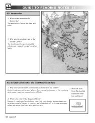
Part 1: Read the hypothesis. Using only your poster with the relief map,<br />
give four reasons that support this hypothesis. (Hint: Include reasons why<br />
some other regions would not be good for settlement.)<br />
Hypothesis 1: Most early people settled on the North China Plain because<br />
of its geography.<br />
These four reasons support this hypothesis:<br />
1.<br />
2.<br />
3.<br />
4.<br />
Part 2<br />
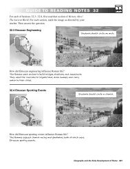
1. Read Section <strong>19</strong>.8. Add any additional information that shows that most<br />
early people settled on the North China Plain because of its geography.<br />
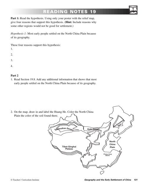
2. On the map, draw in and label the Huang He. Color the North China<br />
Plain the color of the soil found there.<br />
Takli<br />
makan Desert<br />
Gobi Desert<br />
Manchurian<br />
Plain<br />
Northeastern<br />
Plain<br />
Tibet-Qinghai<br />
Plateau<br />
North<br />
China<br />
Plain<br />
Chang Jiang<br />
Basins<br />
© Teachers’ Curriculum Institute Geography and the Early Settlement of China 131
<strong>READING</strong> <strong>NOTES</strong> <strong>19</strong><br />
Part 1: Read the hypothesis. Using only your poster with the relief map,<br />
give two reasons that support this hypothesis.<br />
Hypothesis 2: China was isolated from other civilizations because of<br />
its geography.<br />
These two reasons support this hypothesis:<br />
1.<br />
2.<br />
Part 2<br />
1. Read Section <strong>19</strong>.9. Add any additional information that shows China<br />
was isolated from other civilizations because of its geography.<br />
2. On the map, color the areas that caused China to be isolated from<br />
other civilizations.<br />
Takli<br />
makan Desert<br />
Gobi Desert<br />
Manchurian<br />
Plain<br />
Northeastern<br />
Plain<br />
Tibet-Qinghai<br />
Plateau<br />
North<br />
China<br />
Plain<br />
Chang Jiang<br />
Basins<br />
132 Lesson <strong>19</strong> © Teachers’ Curriculum Institute
<strong>READING</strong> <strong>NOTES</strong> <strong>19</strong><br />
Part 1: Read the hypothesis. Using only your poster with the relief map,<br />
give five reasons that support this hypothesis. (Hint: Think about physical<br />
features, climate, and vegetation in each geographic region. What differences<br />
might result in how people lived, what they ate, or what kinds of<br />
shelter they used?)<br />
Hypothesis 3: Because of geography, several ways of life developed<br />
in China.<br />
These five reasons support this hypothesis:<br />
1.<br />
2.<br />
3.<br />
4.<br />
5.<br />
Part 2<br />
1. Read Section <strong>19</strong>.10. Add any additional information that shows that<br />
several ways of life developed in China because of geography.<br />
2. In each box, draw one<br />
type of food, shelter, or<br />
activity (such as farming<br />
or herding animals) that<br />
might be found in that<br />
geographic region.<br />
Takli<br />
makan Desert<br />
Gobi Desert<br />
Manchurian<br />
Plain<br />
Northeastern<br />
Plain<br />
Tibet-Qinghai<br />
Plateau<br />
North<br />
China<br />
Plain<br />
Chang Jiang<br />
Basins<br />
© Teachers’ Curriculum Institute Geography and the Early Settlement of China 133
PROCESSING <strong>19</strong><br />
The Chinese often drew pictures of the landscape on scrolls. Choose two<br />
of China’s geographic regions, and illustrate the geography and way of<br />
life in each region. Your scroll might show these things:<br />
• physical features (such as mountains and rivers), climate, and<br />
vegetation<br />
• clothing, food, or shelter of people living in that region<br />
Use at least four colors. Below your scroll, write a paragraph that<br />
compares and contrasts the two regions.<br />
134 Lesson <strong>19</strong> © Teachers’ Curriculum Institute