- Page 2 and 3: GEOLOGY OF GREENLAND SURVEY BULLETI
- Page 5 and 6: 15 14 12 2 13 3 11 10 4,5 6 9 1 500
- Page 7 and 8: ■ ■ ■ ■ ■ ■ ■ ■ ■
- Page 9 and 10: Canada 52° Ellesmere Island Pituff
- Page 11 and 12: Atlantic margin and an important da
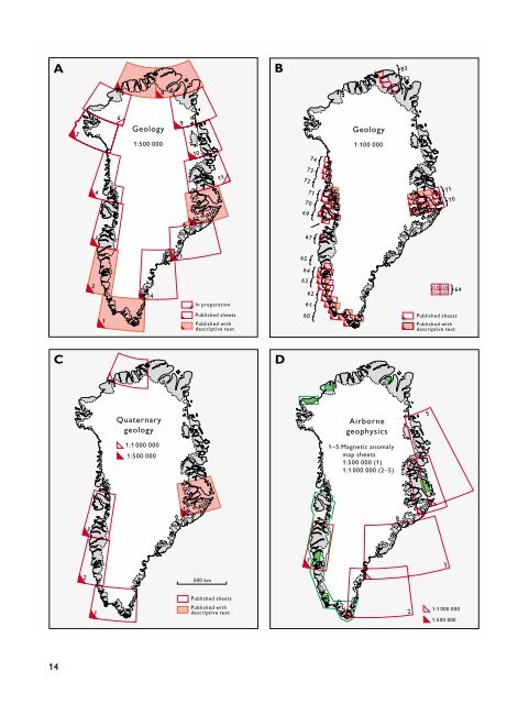
- Page 13: (see Fig. 2B). One map sheet from e
- Page 17 and 18: A B C D E Fig. 4. Selected Survey p
- Page 19 and 20: elieved to be related to the openin
- Page 21 and 22: Stemmerik, L. & Trappe, J. (eds) 20
- Page 23 and 24: ion of Mining and Metallurgy, secti
- Page 25 and 26: Petroleum geological activities in
- Page 27 and 28: m below RT WNW ESE msecs TWT QM 200
- Page 29 and 30: Santonian sandstones of reservoir q
- Page 31 and 32: m below TD 1000 1500 2000 2500 3000
- Page 33 and 34: 8. Thermal maturity data show a sim
- Page 35 and 36: Acquisition of high-resolution mult
- Page 37 and 38: Table 1. Acquisition equipment and
- Page 39 and 40: W SP 8500 9000 9500 E GEUS00-13 Bas
- Page 41 and 42: Summary The cruise was very success
- Page 43 and 44: 54˚ 01-06 Sample location, R/V Por
- Page 45 and 46: N seabed S 250 m Holocene 275 m 10
- Page 47 and 48: quently almost no ice-rafting. This
- Page 49 and 50: Palaeolimnological investigation of
- Page 51 and 52: of increase of individual pollutant
- Page 53 and 54: Fig. 4. The region along the ice ma
- Page 55 and 56: Determining the date of ice-melt fo
- Page 57 and 58: A B B Fig. 3. Remote-controlled cam
- Page 59 and 60: temperature thermistors and AWS) re
- Page 61 and 62: Table 1. Lakes and ponds sampled fo
- Page 63 and 64: Taxon Table 2. Chironomid exuviae c
- Page 65 and 66:
olimnological data therefore not on
- Page 67 and 68:
46° 45° Brattahlid Eastern Settle
- Page 69 and 70:
Fig. 5. Sonograph from Igaliku Fjor
- Page 71 and 72:
The Nalunaq gold prospect, South Gr
- Page 73 and 74:
documented by chip and saw-cut chan
- Page 75 and 76:
High grade tower rejects Sample tow
- Page 77 and 78:
Reconnaissance for noble metals in
- Page 79 and 80:
Fig. 3. View to the west of ‘Tåg
- Page 81 and 82:
A B C 2 cm D Fig. 4. Four hand-spec
- Page 83 and 84:
Brooks, C.K. & Gill, C.O. 1982: Com
- Page 85 and 86:
I I I I I I I I 40° 32° 24° 16°
- Page 87 and 88:
W Miki Fjord opx-bearing lavas Not
- Page 89 and 90:
'Lindsay Nunatak' 'N. Polar Bear Nu
- Page 91 and 92:
tains 30 x 200 cm cross-bedded sand
- Page 93 and 94:
Approximate stratigraphic height (m
- Page 95 and 96:
Fig. 9. Southern part of the Kanger
- Page 97 and 98:
With the completion of the DLC regi
- Page 99 and 100:
Mineralogy and Petrology 128, 45-51
- Page 101 and 102:
Kangerlussuaq Nansen Fjord Scoresb
- Page 103 and 104:
Fig. 3. Upper Cretaceous marine mud
- Page 105 and 106:
Stratigraphy Biostratigraphy Detail
- Page 107 and 108:
stratigraphy, lithology, palaeomagn
- Page 109 and 110:
▲ ▲ ▲ 27° 21° Inland Ice Gr
- Page 111 and 112:
C SC K B C-O Fig. 5. Bastionen seen
- Page 113 and 114:
Fig. 6. Vertical cross-section of w
- Page 115 and 116:
Special Issue 3, 91-100. Liverpool,
- Page 117 and 118:
Table 1. Site locations Site 1 As f
- Page 119 and 120:
Fig. 4. Experimental Site 9 origina
- Page 121 and 122:
Artic Temperature Trends (1966-1995
- Page 123 and 124:
Projects MINEO and HyperGreen: airb
- Page 125 and 126:
Table 1. Spatial and spectral chara
- Page 127 and 128:
For the HyperGreen project, the kno
- Page 129 and 130:
0° 84° 90° 83° 80° 82° 81° 7
- Page 131 and 132:
stations are operated. The observat