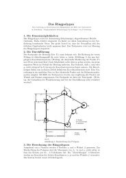
Waterland–People: On Structure and Origin of Crannogs ...
Waterland–People: On Structure and Origin of Crannogs ...
Waterland–People: On Structure and Origin of Crannogs ...

Create successful ePaper yourself
Turn your PDF publications into a flip-book with our unique Google optimized e-Paper software.
Chapter 3<br />
Sites assessment<br />
Implying that human observation <strong>and</strong> evolution is strongly interconnected with natural<br />
events <strong>and</strong> their folklore <strong>and</strong> when researching lake settlements <strong>and</strong> the like it is necessary<br />
to have a wider look at previous natural events like the rise <strong>and</strong> fall <strong>of</strong> the sea level or<br />
tsunamis, the evolution <strong>of</strong> the climate - the environment ’water’ in a wide <strong>and</strong> early range<br />
<strong>of</strong> contexts -, <strong>and</strong> at the same time search for possible ’mother’ isl<strong>and</strong>s who could prove<br />
to be the ’mother’ <strong>of</strong> the whole idea. The persistence <strong>of</strong> crannogs in the British isles<br />
over millennia is pro<strong>of</strong> <strong>of</strong> a continuing idea that clearly involves all aspects <strong>of</strong> water, it’s<br />
impression on human perception <strong>and</strong> its value.<br />
3.1 Environment<br />
The environmental evidence is sparse but remains an ongoing field <strong>of</strong> research, as recent<br />
studies in sea–level change around Orkney coasts show. There is a definite need for<br />
information as it is becoming clearer that sites <strong>of</strong> earliest occupation <strong>of</strong> the Orkney<br />
Isl<strong>and</strong>s may be generally submerged due to the Orkney Isl<strong>and</strong>’s location at the outskirts<br />
<strong>of</strong> glaciation. In fact that means that the sealevel rise is faster than the remaining uplift<br />
which, compared to the rest <strong>of</strong> Scotl<strong>and</strong>, results in the uplift value being negative.<br />
3.1.1 Topography, streams <strong>and</strong> outlets<br />
’The central part <strong>of</strong> West Mainl<strong>and</strong> consists <strong>of</strong> a wide, almost flat, open plain in which<br />
small, slaggish streams me<strong>and</strong>er through a succession <strong>of</strong> low–lying, marshy hollows<br />
<strong>and</strong> shallow lochs. [...] This central portion is some 40 square miles in extend <strong>and</strong> is<br />
surrounded by a girdle <strong>of</strong> low hills which is breached on the south at the Bridge <strong>of</strong> Waith<br />
where the waters from the Loch <strong>of</strong> Stennes enter the sea through the channel known<br />
as The Bush. It is by this exit that the main drainage <strong>of</strong> the area is discharged, though<br />
15