Waterland–People: On Structure and Origin of Crannogs ...
Waterland–People: On Structure and Origin of Crannogs ...
Waterland–People: On Structure and Origin of Crannogs ...

You also want an ePaper? Increase the reach of your titles
YUMPU automatically turns print PDFs into web optimized ePapers that Google loves.
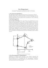
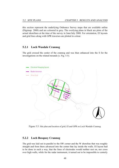
5.2. SITE PLANS CHAPTER 5. RESULTS AND ANALYSIS<br />
this section represent the underlying Ordnance Survey maps that are available online<br />
(Digimap 2008) <strong>and</strong> are coloured in grey. The overlying plans in black are plots <strong>of</strong> the<br />
actual shorelines at the time <strong>of</strong> the survey in June/July 2008. For orientation, EI layouts<br />
<strong>and</strong> grid lines along with GPR traverses are plotted in colour.<br />
5.2.1 Loch Wasdale Crannog<br />
The grid crossed the center <strong>of</strong> the crannog <strong>and</strong> was then enhanced into the S for the<br />
investigations on the related mounds (s. Fig. 5.5).<br />
Electrical Imaging layout<br />
Radar traverses<br />
20 m Grid<br />
A<br />
6<br />
7<br />
8<br />
C<br />
B<br />
1<br />
2<br />
3<br />
4<br />
5<br />
Figure 5.5: Site plan <strong>and</strong> location <strong>of</strong> grid, EI <strong>and</strong> GPR on Loch Wasdale Crannog.<br />
5.2.2 Loch Bosquoy Crannog<br />
The grid was laid out in parallel to the SW corner <strong>and</strong> the W shoreline that was roughly<br />
straight <strong>and</strong> from there advanced into the center that lay inside the walls. EI layout had<br />
to be done in such a way, that the lines <strong>of</strong> electrodes would neither rest on, nor cross<br />
over high walls, while for the radar instrument, it turned out to be impossible to centerly<br />
48