B. Taylor Troiani - Gulf Coast Section SEPM
B. Taylor Troiani - Gulf Coast Section SEPM
B. Taylor Troiani - Gulf Coast Section SEPM

Create successful ePaper yourself
Turn your PDF publications into a flip-book with our unique Google optimized e-Paper software.
The Impact of Changing Winds on Estuarine Evolution,<br />
Copano Bay, TX<br />
Purpose:<br />
The fulfillment of partial requirements for the Degree of Master of Science in Geology Oklahoma<br />
State University, Stillwater OK<br />
Abstract:<br />
Over 160 high-resolution 2-D seismic survey lines and 6 sediment cores up to 16 m in length<br />
were collected from Copano Bay along the northwestern <strong>Gulf</strong> of Mexico in order to study the impact of<br />
climate change on estuarine systems within an incised valley over the last 10 k.y. Over the last 18 k.y.<br />
years, sea level has risen between 90 and 100 m along the northwestern <strong>Gulf</strong> of Mexico and coastal<br />
environments experienced a general landward migration within the <strong>Gulf</strong> <strong>Coast</strong> incised valleys. Both core<br />
and seismic data reveal that this retreat was punctuated by major flooding events. These flooding events<br />
represent a rapid landward shift of estuarine environments. Possible causes for the formation of the<br />
flooding events include tectonics, sea-level fluctuations, climate changes, and autocyclic events such as<br />
the flooding of fluvial terraces. Most climatically-driven mechanisms for environmental changes within<br />
estuaries focus on changes in the amount of sediment delivered to the estuarine system. One very<br />
important and often overlooked aspect of climate change is changes in wind strength and direction.<br />
Previous studies suggest that most shallow lagoons and estuaries are in equilibrium with sediment input<br />
and wave-energy dissipation. Due to this equilibrium, most modern accumulation rates equal the rate of<br />
relative sea-level rise within shallow estuaries. My central hypothesis is that a disruption in the<br />
equilibrium between accumulation rates and wave energy is an overlooked cause for para-sequence<br />
development within estuaries and incised valleys. We suggest that with stronger winds or increased fetch,<br />
shallow estuaries will become deeper and accumulating sediments will become coarser. With weaker<br />
winds or decreased fetch, estuaries will become shallower and accumulating sediments will become finer.<br />
Need:<br />
Support is needed for radiocarbon dating of selected organic material from one of the 6 cores<br />
taken within Copano Bay, TX.<br />
Goals:<br />
The goal of this study is to further investigate climate as a mechanism for para-sequence<br />
development within incised valleys. This will be accomplished by constructing a three-dimensional<br />
model of Holocene sub-surface sediments in Copano Bay, TX.
Objectives:<br />
In order to accomplish my goals, I will determine -<br />
1) The age of flooding surfaces within the valley<br />
2) The volume of sediment in para-sequences or between flooding surfaces<br />
3) The determination of lithofacies between flooding surfaces<br />
4) Detailed grain-size analysis of sediments across flooding<br />
surfaces. Rational:<br />
The project described in this proposal will address the impact of changing wind strengths on estuarine<br />
evolution. Most studied mechanisms evolved as responses to climate changes mostly pertain to changes in<br />
sediment flux delivered to the estuarine systems. One very important and often overlooked aspect of climate<br />
change is changes in wind strength and direction. Previous studies suggest that wind is the dominant<br />
forcing agent regulating estuarine sedimentary processes.<br />
Study Area:<br />
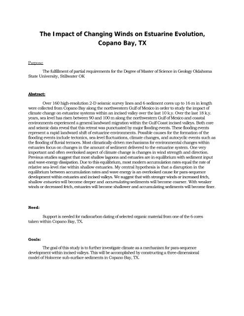
Copano Bay, is located along the Texas <strong>Gulf</strong> <strong>Coast</strong> about 20 miles north of Corpus Christi,<br />
Texas. It is situated approximately parallel to the present coast line of the <strong>Gulf</strong> of Mexico. The bay covers<br />
an area less than 168 sq. km. Water depths range from 0.6-2.7 m. but nearly 75% of the bay has a depth of<br />
2.1 m. The prevailing winds are onshore from the southeast during the late spring to early fall. During the<br />
late fall to early spring, the winds frequently have strong northerly components directed offshore. Aransas<br />
Bay and St. Joseph Island separate Copano Bay from the <strong>Gulf</strong> of Mexico. The bay lies within a sub humid<br />
to semi-arid climate zone (Thornthwaite 1948) with evaporation exceeding precipitation. Copano Bay has<br />
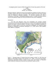
three primary sources of freshwater: the Mission River, the Aransas River, and Copano Creek (figure 1).<br />
Major fluvial sediment is supplied to the bay by the Mission, and Aransas River (Wright 1980). During a sealevel<br />
fall between 18-120 ka the rivers and creeks cut an incised valley 21 m deep (Wright 1980).<br />
N<br />
Copano<br />
Bay<br />
Figure 1 General Map of Copano Bay, Texas
Impact of Winds:<br />
Price (1947) and Nichols (1989) noticed that sedimentation and accumulation rates along with<br />
lagoonal surface area (ie. fetch areas) are in equilibrium with wave energy dissipation. In most lagoons<br />
Nichols (1989) noticed that sediment accumulation rates equal the rate of relative sea-level rise. These<br />
observations suggest that most lagoons are in equilibrium with sediment input and wave energy<br />
dissipation. Wave energy dissipation, i.e., the depth of effective marine planation (scour), is a function of<br />
fetch and average wind speed (Price 1947). Thus, changes in wind strength or in direction will disrupt<br />
this equilibrium and cause a change in the accumulation rate of sediments within a bay. Shideler (1984)<br />
determined that wind is the dominant forcing agent regulating estuarine sedimentary processes. Winddriven<br />
currents, i.e. wave orbital's, have the ability to resuspend bay-floor sediments in the water-column<br />
and there is a direct relationship between mean wind speed and sediment concentration in the watercolumn<br />
Shideler (1984). The resuspended sediments in the water-column consist of poorly sorted claysize<br />
to very fine silt-size detritus (Shideler 1984).<br />
Methods:<br />
I am working closely with Dr.Tim Dellapenna at Texas A&M at Galveston, Tim has been very<br />
generous by allowing me to use over 160 high-resolution 2-D seismic survey lines with spacing intervals<br />
of 150 m in Copano Bay, TX. Using this data set to pick coring sites, we collected four rotary-push cores<br />
up to 16 m in length and two vibarcores up to 3 m in length aboard the R/V Trinity. The cores and<br />
seismic data will be used to study the internal architecture of Copano Bay and determine the mechanisms<br />
responsible for the development of flooding surfaces within the bay. The cores will be described using<br />
coarse fraction analysis according to the procedure of Shepard (1954). Grain size will be analyzed every<br />
20 cm and every 5 cm above and below recognized flooding surfaces within cores with a CILAS 1180L<br />
Laser Particle Size Analyzer. Sedimentary structures, macro fauna, and micro fauna will be included in<br />
the core description and used for interpreting depositional environment. Selected organic material from<br />
the cores such as shells and wood fragments will be sent to Beta Analytical and the University of Tokyo<br />
for radiocarbon dating.<br />
Expected Results:<br />
I will create paleo geographic maps of the bay through time using both the seismic and core data<br />
with the help of Kingdom Suite software. These maps will illustrate the timing and nature of valley fill<br />
within Copano Bay. I will also create isopach maps between the flooding surfaces within the bay. These<br />
isopach maps will be used to calculate the volume of sediment between flooding surfaces. I expect to<br />
see a coarsing of grain size in middle bay deposits where there was an increase in either fetch or paleo wind<br />
strength or both.
References:<br />
NICHOLS, M.M., 1989, SEDIMENT ACCUMULATION RATES AND RELATIVE SEA-LEVEL RISE IN<br />
LAGOONS: Marine Geology, v. 88, p. 201-219.<br />
PRICE, W.A., 1947, Equilibrium of form and forces in tidal basins of coast of Texas and<br />
Louisiana: Bulletin of the American Association of Petroleum Geologists, v. 31, p.<br />
1663-1619.<br />
SHEPARD, F.P., 1954, Sedimentary environments differentiated by coarse-fraction studies:<br />
Bulletin of the American Association of Petroleum Geologists, v. 38, p. 1802-1792.<br />
SHIDELER, G.L., 1984, Suspended sediment responses in a wind-dominated estuary of the<br />
Texas <strong>Gulf</strong> <strong>Coast</strong>, Journal of Sedimentary Petrology: United States, Society of<br />
Economic Paleontologists and Mineralogists : Tulsa, OK, United States, p. 745-731.<br />
THORNTHWAITE, C.W., 1948, An approach toward a rational classification of climate:<br />
Geographical review v. 38, p. 55-94.<br />
WRIGHT, S.S., 1980, Seismic Stratigraphy and Depositional History of Holocene Sediments<br />
on the Central Texas <strong>Gulf</strong> <strong>Coast</strong>: The University of Texas at Austin Austin, TX, 123 p.
Biography<br />
B. <strong>Taylor</strong> <strong>Troiani</strong><br />
Personal Data:<br />
Born: September 13, 1979 in San Antonio, TX<br />
Parents: Gay and Lendy <strong>Troiani</strong><br />
Education:<br />
Wichita State University, Wichita, KS Dec. 2006<br />
Oklahoma State University, Stillwater, OK expected Dec. 2009<br />
Experience:<br />
Contract Project Geologist 2007: Pogo Producing Company, Tulsa, OK<br />
Associate Geologist 2007: Crow Creek Energy, Tulsa, OK<br />
Geologist Intern 2008: Kirkpatrick Oil Company, Oklahoma City, OK<br />
Professional Membership:<br />
1. Society for Sedimentary Geology (<strong>SEPM</strong>)<br />
2. American Association of Petroleum Geologist (AAPG)<br />
3. Oklahoma City Geological Society