

Ecuador - GFDRR
Ecuador - GFDRR
Ecuador - GFDRR

You also want an ePaper? Increase the reach of your titles
YUMPU automatically turns print PDFs into web optimized ePapers that Google loves.
Disaster Risk Management in Latin America and the Caribbean Region: <strong>GFDRR</strong> Country Notes<br />
disaster risk profile<br />
According to the World Bank’s Natural Disaster<br />
Hotspot study 2 , <strong>Ecuador</strong> ranks 18th among<br />
countries with the highest economic risk<br />
exposure to three or more hazards. 66% of<br />
the population lives in urban areas and 96% of this<br />
population lives in the coastal and mountainous<br />
regions, exposed to seismic, volcanic, flood, landslide,<br />
and El Niño hazards. The volcano Tungurahua<br />
is currently active. Floods and landslides occur<br />
frequently and affect the population as well as the<br />
productive sectors.<br />
Geological Hazards<br />
<strong>Ecuador</strong> is a highly seismically active territory.<br />
The subduction zone of the Nazca and the South<br />
American plates has been the source of the major<br />
earthquakes of Esmeraldas (1906, 1958, and<br />
1979) and Caraquez Bay (1998). Likewise, the<br />
continental fault system which crosses the country<br />
in the northeast direction and in the foothills of the<br />
Cordillera Real has caused strong earthquakes<br />
(1541, 1987). The largest cities in the country (on the<br />
coast and in the mountains) are located in areas with<br />
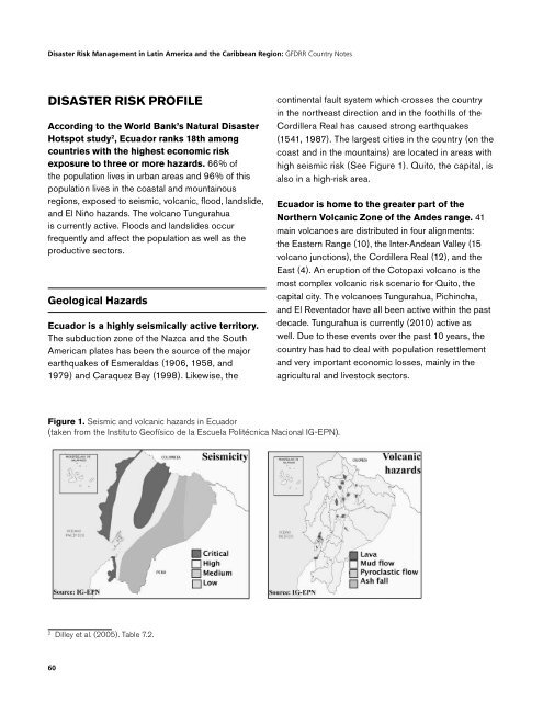
high seismic risk (See Figure 1). Quito, the capital, is<br />
also in a high-risk area.<br />
<strong>Ecuador</strong> is home to the greater part of the<br />
Northern Volcanic Zone of the Andes range. 41<br />
main volcanoes are distributed in four alignments:<br />
the Eastern Range (10), the Inter-Andean Valley (15<br />
volcano junctions), the Cordillera Real (12), and the<br />
East (4). An eruption of the Cotopaxi volcano is the<br />
most complex volcanic risk scenario for Quito, the<br />
capital city. The volcanoes Tungurahua, Pichincha,<br />
and El Reventador have all been active within the past<br />
decade. Tungurahua is currently (2010) active as<br />
well. Due to these events over the past 10 years, the<br />
country has had to deal with population resettlement<br />
and very important economic losses, mainly in the<br />
agricultural and livestock sectors.<br />
Figure 1. Seismic and volcanic hazards in <strong>Ecuador</strong><br />
(taken from the Instituto Geofísico de la Escuela Politécnica Nacional IG-EPN).<br />
2<br />
Dilley et al. (2005). Table 7.2.<br />
60


