Nature-GIS White Paper
Nature-GIS White Paper
Nature-GIS White Paper

You also want an ePaper? Increase the reach of your titles
YUMPU automatically turns print PDFs into web optimized ePapers that Google loves.
<strong>Nature</strong>-<strong>GIS</strong><br />
A European thematic network for Protected Areas/<strong>Nature</strong> Preservation<br />
and Geographical Information<br />
Project IST-2001-34641<br />
<strong>Nature</strong>-<strong>GIS</strong> <strong>White</strong> <strong>Paper</strong><br />
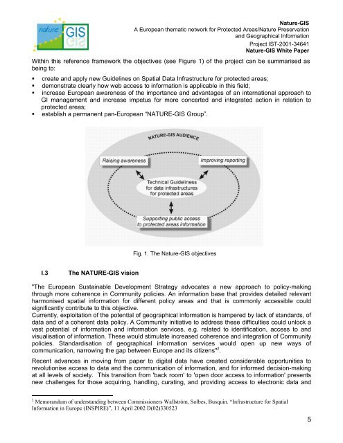
Within this reference framework the objectives (see Figure 1) of the project can be summarised as<br />
being to:<br />
• create and apply new Guidelines on Spatial Data Infrastructure for protected areas;<br />
• demonstrate clearly how web access to information is applicable in this field;<br />
• increase European awareness of the importance and advantages of an international approach to<br />
GI management and increase impetus for more concerted and integrated action in relation to<br />
protected areas;<br />
• establish a permanent pan-European “NATURE-<strong>GIS</strong> Group”.<br />
Fig. 1. The <strong>Nature</strong>-<strong>GIS</strong> objectives<br />
I.3 The NATURE-<strong>GIS</strong> vision<br />
"The European Sustainable Development Strategy advocates a new approach to policy-making<br />
through more coherence in Community policies. An information base that provides detailed relevant<br />
harmonised spatial information for different policy areas and that is commonly accessible could<br />
significantly contribute to this objective.<br />
Currently, exploitation of the potential of geographical information is hampered by lack of standards, of<br />
data and of a coherent data policy. A Community initiative to address these difficulties could unlock a<br />
vast potential of information and information services, e.g. related to identification, access to and<br />
visualisation of information. These would stimulate increased coherence and integration of Community<br />
policies. Standardisation of geographical information services would open up new ways of<br />
communication, narrowing the gap between Europe and its citizens" 2 .<br />
Recent advances in moving from paper to digital data have created considerable opportunities to<br />
revolutionise access to data and the communication of information, and for informed decision-making<br />
at all levels of society. This transition from 'back room' to 'open door access to information' presents<br />
new challenges for those acquiring, handling, curating, and providing access to electronic data and<br />
2 Memorandum of understanding between Commissioners Wallstróm, Solbes, Busquin. “Infrastructure for Spatial<br />
Information in Europe (INSPIRE)”, 11 April 2002 D(02)330523<br />
5