Nature-GIS White Paper
Nature-GIS White Paper
Nature-GIS White Paper

You also want an ePaper? Increase the reach of your titles
YUMPU automatically turns print PDFs into web optimized ePapers that Google loves.
<strong>Nature</strong>-<strong>GIS</strong><br />
A European thematic network for Protected Areas/<strong>Nature</strong> Preservation<br />
and Geographical Information<br />
Project IST-2001-34641<br />
<strong>Nature</strong>-<strong>GIS</strong> <strong>White</strong> <strong>Paper</strong><br />
In this scheme the “Technical guidelines for data infrastructures for protected areas” (WP6) provide<br />
the means to summarise all of the technical achievements of the work-packages.<br />
The first phase of the NATURE-<strong>GIS</strong> programme will be to assess user needs, define and characterise<br />
stakeholders and survey typical uses of GI in connection with nature conservation. Based upon this, it<br />
will be possible to establish the data that is required in order to specify the common kernel of GI<br />
content needed to describe protected areas. NATURE-<strong>GIS</strong> will also identify how the information can<br />
best be managed and will define a framework for these specialised spatial databases. The results of<br />
this assessment will enable access via the Internet to high-quality and comprehensive GI-<strong>GIS</strong><br />
information on European protected areas.<br />
In the second phase the project team will produce technical guidelines for data infrastructures for<br />
protected areas in order to contribute to improved geo-data access and exchange through<br />
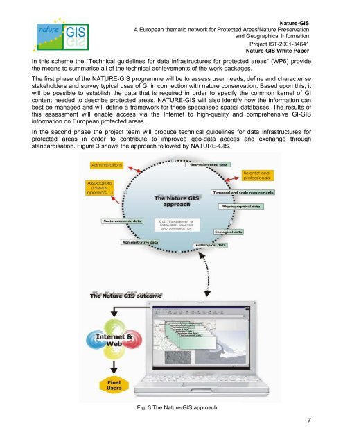
standardisation. Figure 3 shows the approach followed by NATURE-<strong>GIS</strong>.<br />
Fig. 3 The <strong>Nature</strong>-<strong>GIS</strong> approach<br />
7