The Danube submarine canyon (Black Sea ... - geo.edu.ro
The Danube submarine canyon (Black Sea ... - geo.edu.ro
The Danube submarine canyon (Black Sea ... - geo.edu.ro

You also want an ePaper? Increase the reach of your titles
YUMPU automatically turns print PDFs into web optimized ePapers that Google loves.
252<br />
I. Popescu et al. / Marine Geology 206 (2004) 249–265<br />
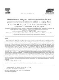
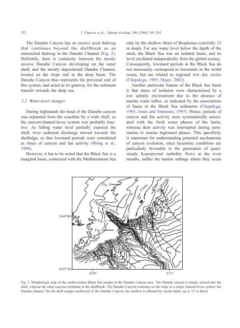
<st<strong>ro</strong>ng>The</st<strong>ro</strong>ng> <st<strong>ro</strong>ng>Danube</st<strong>ro</strong>ng> Canyon has an e<strong>ro</strong>sive axial thalweg<br />
that continues beyond the shelfbreak as an<br />
entrenched thalweg in the <st<strong>ro</strong>ng>Danube</st<strong>ro</strong>ng> Channel (Fig. 2).<br />
Definitely, there is continuity between the mostly<br />
e<strong>ro</strong>sive <st<strong>ro</strong>ng>Danube</st<strong>ro</strong>ng> Canyon developing on the outer<br />
shelf, and the mostly depositional <st<strong>ro</strong>ng>Danube</st<strong>ro</strong>ng> Channel,<br />
located on the slope and in the deep basin. <st<strong>ro</strong>ng>The</st<strong>ro</strong>ng><br />
<st<strong>ro</strong>ng>Danube</st<strong>ro</strong>ng> Canyon thus represents the p<strong>ro</strong>ximal end of<br />
this system, and acted as its gateway for the sediment<br />
transfer towards the deep sea.<br />
2.2. Water-level changes<br />
During highstands the head of the <st<strong>ro</strong>ng>Danube</st<strong>ro</strong>ng> <st<strong>ro</strong>ng>canyon</st<strong>ro</strong>ng><br />
was separated f<strong>ro</strong>m the coastline by a wide shelf, so<br />
the <st<strong>ro</strong>ng>canyon</st<strong>ro</strong>ng>/channel-levee system was p<strong>ro</strong>bably inactive.<br />
As falling water level partially exposed the<br />
shelf, river sediment discharge moved towards the<br />
shelfedge, so that lowstand periods were considered<br />
as times of <st<strong>ro</strong>ng>canyon</st<strong>ro</strong>ng> and fan activity (Wong et al.,<br />
1994).<br />
However, it has to be noted that the <st<strong>ro</strong>ng>Black</st<strong>ro</strong>ng> <st<strong>ro</strong>ng>Sea</st<strong>ro</strong>ng> is a<br />
marginal basin, connected with the Mediterranean <st<strong>ro</strong>ng>Sea</st<strong>ro</strong>ng><br />
only by the shallow Strait of Bosphorus (currently 32<br />
m deep). For any water level below the depth of the<br />
strait, the <st<strong>ro</strong>ng>Black</st<strong>ro</strong>ng> <st<strong>ro</strong>ng>Sea</st<strong>ro</strong>ng> was an isolated basin, and its<br />
level oscillated independently f<strong>ro</strong>m the global eustasy.<br />
Consequently, lowstand periods in the <st<strong>ro</strong>ng>Black</st<strong>ro</strong>ng> <st<strong>ro</strong>ng>Sea</st<strong>ro</strong>ng> do<br />
not necessarily correspond to lowstands in the world<br />
ocean, but are related to regional wet–dry cycles<br />
(Chepalyga, 1985; Major, 2002).<br />
Another particular feature of the <st<strong>ro</strong>ng>Black</st<strong>ro</strong>ng> <st<strong>ro</strong>ng>Sea</st<strong>ro</strong>ng> basin<br />
is that times of isolation were characterized by a<br />
low salinity envi<strong>ro</strong>nment due to the absence of<br />
marine water influx, as indicated by the associations<br />
of fauna in the <st<strong>ro</strong>ng>Black</st<strong>ro</strong>ng> <st<strong>ro</strong>ng>Sea</st<strong>ro</strong>ng> sediments (Chepalyga,<br />
1985; Jones and Simmons, 1997). Hence, periods of<br />
<st<strong>ro</strong>ng>canyon</st<strong>ro</strong>ng> and fan activity were systematically associated<br />
with the fresh water phases of the basin,<br />
whereas their activity was interrupted during semimarine<br />
to marine highstand phases. This specificity<br />
is important for understanding potential mechanisms<br />
of <st<strong>ro</strong>ng>canyon</st<strong>ro</strong>ng> evolution, since lacustrine conditions are<br />
particularly favorable to the generation of quasisteady<br />
hyperpycnal turbidity flows at the river<br />
mouths, unlike the marine settings where they occur<br />
Fig. 2. Morphologic map of the north-western <st<strong>ro</strong>ng>Black</st<strong>ro</strong>ng> <st<strong>ro</strong>ng>Sea</st<strong>ro</strong>ng> margin in the <st<strong>ro</strong>ng>Danube</st<strong>ro</strong>ng> Canyon area. <st<strong>ro</strong>ng>The</st<strong>ro</strong>ng> <st<strong>ro</strong>ng>Danube</st<strong>ro</strong>ng> <st<strong>ro</strong>ng>canyon</st<strong>ro</strong>ng> is deeply incised into the<br />
shelf, whereas the other <st<strong>ro</strong>ng>canyon</st<strong>ro</strong>ng>s terminate at the shelfbreak. <st<strong>ro</strong>ng>The</st<strong>ro</strong>ng> <st<strong>ro</strong>ng>Danube</st<strong>ro</strong>ng> Canyon continues on the slope as a major channel-levee system: the<br />
<st<strong>ro</strong>ng>Danube</st<strong>ro</strong>ng> channel. On the shelf margin northward of the <st<strong>ro</strong>ng>Danube</st<strong>ro</strong>ng> Canyon, the seafloor is affected by recent faults, up to 15 m th<strong>ro</strong>w.