

An integrated approach to mineral exploration and ... - Geus
An integrated approach to mineral exploration and ... - Geus
An integrated approach to mineral exploration and ... - Geus

You also want an ePaper? Increase the reach of your titles
YUMPU automatically turns print PDFs into web optimized ePapers that Google loves.
<strong>An</strong> <strong>integrated</strong> <strong>approach</strong> <strong>to</strong> <strong>mineral</strong> <strong>exploration</strong> <strong>and</strong><br />
environmental assessment in southern <strong>and</strong> eastern<br />
Africa - a pilot study in Tanzania<br />
Report on the project supported by the Danish Council for Development Research<br />
(RUF project number 90953)<br />
Peter. W. U. Appel, Christian M. Glahder, Saidi Mnali, Sospeter Muhongo, Faustin Petro,<br />
Thorkild M. Rasmussen, Henrik Stendal, E. Brian Temu, Leif Thorning & Tapani Tukiainen<br />
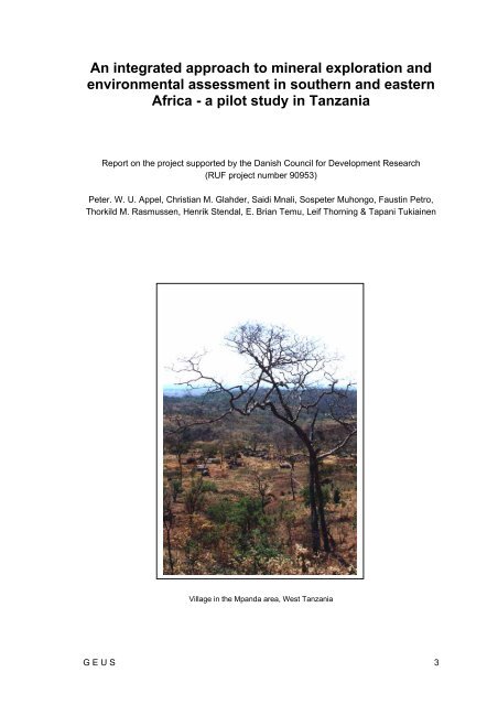
Village in the Mp<strong>and</strong>a area, West Tanzania<br />
G E U S 3
4 G E U S
Contents<br />
Summary 8<br />
Introduction 10<br />
About this report.............................................................................................................10<br />
The pilot project..............................................................................................................10<br />
Compilation <strong>and</strong> evaluation of existing data 14<br />
Topographic data ...........................................................................................................14<br />
Satellite image data........................................................................................................14<br />
Geological maps ............................................................................................................15<br />
Mineral occurrences.......................................................................................................15<br />
Sample Locations...........................................................................................................15<br />
Airborne magnetic data ..................................................................................................15<br />
Fieldwork in the Ubendian Mobile Belt, South-West Tanzania 17<br />
Geology of the Ubendian belt 20<br />
Introduction ....................................................................................................................20<br />
Geological Setting..........................................................................................................20<br />
Tec<strong>to</strong>nometamorphic evolution ......................................................................................21<br />
Economic Geology of the Ubendian belt ........................................................................25<br />
Mp<strong>and</strong>a Mineral Field.....................................................................................................25<br />
Manyoro Deposit............................................................................................................27<br />
Lupa Goldfield................................................................................................................27<br />
Geological results <strong>and</strong> interpretation 29<br />
Lupa Goldfield................................................................................................................29<br />
Mp<strong>and</strong>a Mineral Field.....................................................................................................30<br />
Karema - Ikola - Kipili area.............................................................................................30<br />
<strong>An</strong>alytical results ............................................................................................................31<br />
Pb-iso<strong>to</strong>pes ....................................................................................................................37<br />
Geophysical data compared <strong>to</strong> geology <strong>and</strong> <strong>mineral</strong>isation ...........................................37<br />
Environmental aspects 38<br />
Mercury in the environment............................................................................................38<br />
Other metals in the environment. ...................................................................................39<br />
Mining, l<strong>and</strong> use <strong>and</strong> environmental protection..............................................................40<br />
G E U S 5
Socio-economical issues: 42<br />
Mercury in soap in Tanzania 43<br />
Conclusions 44<br />
Recommendations 46<br />
The joint research project .............................................................................................. 46<br />
Socio-economical Research .......................................................................................... 48<br />
The academic educational programme.......................................................................... 48<br />
Additional objectives ...................................................................................................... 49<br />
Acknowledgements 50<br />
References 51<br />
Appendix 1 55<br />
Summary of main conclusions <strong>and</strong> agreements reached at Planning Seminar ............. 55<br />
Appendix 2 67<br />
Extractions from field diaries: Geological record (HS) <strong>and</strong> Environmental record (CG). 67<br />
Appendix 3 77<br />
Gold mining <strong>and</strong> gold extraction by amalgamation ........................................................ 77<br />
Appendix 4 81<br />
Minutes of the meeting of the <strong>integrated</strong> research project on the Ubendian belt held in<br />
Mp<strong>and</strong>a <strong>to</strong>wn on 27.9.1999 ........................................................................................... 81<br />
Appendix 5 87<br />
Details on the GIS compilation of existing data ............................................................. 87<br />
Appendix 6 93<br />
Geological sample sites <strong>and</strong> analytical data .................................................................. 93<br />
Appendix 7 119<br />
Details on some environmental aspects ...................................................................... 119<br />
Appendix 8 135<br />
Mercury in Soap in Tanzania ....................................................................................... 135<br />
Appendix 9 141<br />
Research proposal from Dr. Kent C. Condie ............................................................... 141<br />
6 G E U S
Appendix 10 143<br />
Letter of support from Professor Idris S. Kikula, Direc<strong>to</strong>r of Research <strong>and</strong> Publications,<br />
University of Dar es Salaam.........................................................................................143<br />
Appendix 11 145<br />
Summary of meetings held in Dar es Salaam <strong>and</strong> Iringa, mostly on environmental<br />
issues...........................................................................................................................145<br />
Appendix 12 151<br />
Danish contribution for an abstract for Eclogite paper..................................................151<br />
G E U S 7
Summary<br />
The pilot project <strong>An</strong> <strong>integrated</strong> <strong>approach</strong> <strong>to</strong> <strong>mineral</strong> <strong>exploration</strong> <strong>and</strong> environmental assessment<br />
in southern <strong>and</strong> eastern Africa, has been very successful scientifically <strong>and</strong> has furthermore<br />
developed good, durable co-working relationships with partners in Tanzania, University<br />
of Dar es Salaam <strong>and</strong> Geological Survey of Tanzania. <strong>An</strong> international network of<br />
researchers has been focused on the Ubendian Mobile Belt in Tanzania.<br />
During the project all existing geoscience data from the Ubendian mobile belt of South-<br />
West Tanzania were compiled <strong>and</strong> evaluated. The results are compiled in GIS ArcView 3.2,<br />
<strong>and</strong> will be made available on CD-ROM.<br />
Fieldwork was carried out in two areas, Lupa goldfield <strong>and</strong> Mp<strong>and</strong>a Mineral Field in South-<br />
West Tanzania. The fieldwork focused on regional <strong>and</strong> detailed geologic studies especially<br />
concerning the origin of the gold-bearing quartz reefs, which are exploited extensively by<br />
small-scale (artisanal) miners. A better underst<strong>and</strong>ing of the origin of the gold in the quartzreefs<br />
will help find new reefs, which will be of benefit <strong>to</strong> the community <strong>and</strong> local enterprise.<br />
The other part of the fieldwork was concerned with environmental aspects <strong>and</strong> sought <strong>to</strong><br />
localise <strong>and</strong> deliniate the extent of heavy metal pollution in the drainage system from previous<br />
copper-lead mining <strong>and</strong> from the extensive use of mercury <strong>to</strong> extract gold by amalgamation.<br />
Heavy metals were traced downstream from an old copper-lead mine. Several of<br />
the ‘amalgamists’ had very high contents of mercury in their hair, <strong>and</strong> the mercury was also<br />
detected in the drainage system. The amalgamation process is, however, not the only<br />
source for the mercury pollution; imported soaps with up <strong>to</strong> 2% mercury also contribute <strong>to</strong><br />
the pollution of humans <strong>and</strong> the drainage systems. A special report on ‘Mercury in soap in<br />
Tanzania’ has been published.<br />
Future projects are listed in the recommendations of this report. Two joint research projects<br />
have already started within the pilot project:<br />
1. A joint project between University of Dar es Salaam, GEUS, <strong>and</strong> University of Oulu<br />
concerning an investigation of an eclogite, depicted by garnet composition <strong>and</strong> zonation,<br />
is well under preparation <strong>and</strong> will be presented at a conference in Austria in April<br />
2000.<br />
2. Lead iso<strong>to</strong>pe studies carried out in Copenhagen in co-operation with Professor R. Frey<br />
(Geological Institute, University of Copenhagen) on samples collected by the field team<br />
in the Mp<strong>and</strong>a area have yielded important new information concerning the timing <strong>and</strong><br />
the origin of the gold <strong>mineral</strong>isations. In the Lupa Goldfield area the gold <strong>mineral</strong>isation<br />
is related <strong>to</strong> the grani<strong>to</strong>id c. 1960 Ma, but Pb-Pb-iso<strong>to</strong>pe data indicate a younger age of<br />
the grani<strong>to</strong>ids than anticipated. In the Mp<strong>and</strong>a Mineral Field the <strong>mineral</strong>isations are all<br />
related <strong>to</strong> younger processes, contemporaneous with the intrusion of the carbonatite<br />
(722+43 Ma). These results have significant implications for future gold <strong>exploration</strong>.<br />
8 G E U S
Interlabora<strong>to</strong>ry comparison has been carried out by analysing the same samples at two<br />
labora<strong>to</strong>ries in Tanzania <strong>and</strong> a commercial labora<strong>to</strong>ry in Canada. This study revealed that<br />
the two labora<strong>to</strong>ries in Tanzania found gold in samples, which are believed <strong>to</strong> be barren.<br />
Based on the success of the pilot project it has been decided <strong>to</strong> apply for funding for two<br />
projects <strong>and</strong> one pilot project <strong>to</strong> be co-ordinated <strong>and</strong> carried out within the same project<br />
area:<br />
1. A four year research project, which will be sought financed by RUF, Danish Ministry of<br />
Foreign Affairs, within geological <strong>and</strong> environmental sciences carried out jointly by geologists<br />
<strong>and</strong> biologists from University of Dar es Salaam, Geological Survey of Tanzania,<br />
Geological Survey of Denmark <strong>and</strong> Greenl<strong>and</strong> (GEUS), <strong>and</strong> National Environmental<br />
Research Institute (NERI).<br />
2. <strong>An</strong> educational programme, which will be sought financed by ENRECA, Danish Ministry<br />
of Foreign Affairs, initially for a period of three years. It is intended <strong>to</strong> up-grade eighteen<br />
Bachelors of Science <strong>to</strong> Masters of Science <strong>and</strong> three <strong>to</strong> four Masters <strong>to</strong> Ph. D. within<br />
geological <strong>and</strong> environmental sciences. The student training projects will be <strong>integrated</strong><br />
in<strong>to</strong> the science project.<br />
3. A pilot project within socio-economic sciences will be carried out, provided RUF funding<br />
can be obtained. This pilot project will investigate economic, cultural, demographic <strong>and</strong><br />
socio-environmental relations which have been identified as relevant themes <strong>to</strong> explore:<br />
organisation of mining activities, labour force <strong>and</strong> its origin, as well as relations <strong>to</strong> alternative<br />
l<strong>and</strong> use, livelihoods, <strong>and</strong> tenure arrangements are examples of issues in question.<br />
G E U S 9
Introduction<br />
About this report<br />
This report is the final report for the Danish Council for Development Research (RUF) project<br />
no 90953, h<strong>and</strong>ed in <strong>to</strong> RUF at the successful conclusion of the pilot project in Tanzania<br />
in February – March 2000.<br />
The report must serve as part of the required documentation for the activities <strong>and</strong> results of<br />
the pilot project. For that reason rather detailed information has been included in the twelve<br />
appendices. The main part of the report, the first 45 pages, contains similar information, but<br />
in an abbreviated form, which will give a good overview of the pilot project, its objectives,<br />
activities <strong>and</strong> results. However, for a full <strong>and</strong> detailed underst<strong>and</strong>ing, it may in some cases<br />
be necessary <strong>to</strong> consult the appendices.<br />
Figures <strong>and</strong> tables of the main text <strong>and</strong> the first eleven appendices have been numbered<br />
consecutively. The ‘References’ section includes all references in the main text <strong>and</strong> in the<br />
appendices.<br />
The content of the report reflects the situation as it was at the time of printing mid February.<br />
Some activities will, however, continue until final publication has taken place. The continuation<br />
of some of the activities will depend on funding being achieved.<br />
The pilot project<br />
The pilot project: <strong>An</strong> <strong>integrated</strong> <strong>approach</strong> <strong>to</strong> <strong>mineral</strong> <strong>exploration</strong> <strong>and</strong> environmental assessment<br />
in southern <strong>and</strong> eastern Africa - a pilot study in Tanzania, hereafter named the<br />
pilot project, was initiated by the Geological Survey of Denmark <strong>and</strong> Greenl<strong>and</strong> (GEUS)<br />
early 1999. It is a joint project involving co-operation between GEUS, lead agency, the National<br />
Environmental Research Institute (NERI), the Geological Survey of Tanzania (GST)<br />
<strong>and</strong> the Department of Geology, University of Dar es Salaam (DGUDES). The Danish<br />
Council for Development Research (RUF) finances the pilot project for the period 1 st June<br />
1999 <strong>to</strong> 15 th March 2000 under the Danish Ministry of Foreign Affairs.<br />
The initial one-year pilot project reported here encompassed the following activities:<br />
• The compilation <strong>and</strong> <strong>integrated</strong> evaluation of existing geoscience <strong>and</strong> environmental<br />
data from a study area suggested by Tanzanian collabora<strong>to</strong>rs, in co-operation with<br />
partners in Tanzania.<br />
• Four weeks of fieldwork in the study area <strong>to</strong> follow-up on conclusions from the initial<br />
evaluation <strong>and</strong> <strong>to</strong> investigate general geology, <strong>mineral</strong>isation patterns, <strong>and</strong> environ<br />
10 G E U S
•<br />
Figure 1. Field area, South-West Tanzania, indicated by red rectangel<br />
G E U S 11
12 G E U S
mental indica<strong>to</strong>rs. Personnel from GEUS <strong>and</strong> NERI were involved in the fieldwork in<br />
close co-operation with participants from the Geological Survey of Tanzania <strong>and</strong> the<br />
University of Dar es Salaam.<br />
• The compilation <strong>and</strong> interpretation of results from the fieldwork, again in co-operation<br />
with contacts in Tanzania. Production of pro<strong>to</strong>types of GIS databases with data relevant<br />
for use of authorities in Tanzania, of interest for mining companies <strong>and</strong> for further research.<br />
Publication of new data <strong>and</strong> results of the work will be undertaken. Preparations<br />
for incorporation of socio-economical issues in the main project.<br />
• The formulation of research plans for a main project, subject <strong>to</strong> a successful outcome of<br />
the pilot project.<br />
• The development of good, durable co-working relationships with partners in Tanzania<br />
<strong>and</strong> internationally.<br />
During 11 <strong>to</strong> 14 June 1999 a planning seminar was held in Copenhagen with the following<br />
participants:<br />
Peter Appel (PA), GEUS Geological Survey of Denmark <strong>and</strong> Greenl<strong>and</strong><br />
Gert Asmund (GA) NERI National Environmental Research Institute<br />
Christian Glahder (CG) NERI<br />
Sospeter Muhongo (SM) DGUDES Department of Geology, University of Dar es Salaam<br />
Faustin Petro (FP) GST Geological Survey of Tanzania<br />
Henrik Stendal (HS) GEUS<br />
Leif Thorning (LT) GEUS<br />
Tapani Tukiainen (TT) GEUS<br />
During the planning seminar it was discussed where in Tanzania the activities of the pilot<br />
project should take place. Two areas were discussed, the area south of Lake Vic<strong>to</strong>ria <strong>and</strong><br />
the Ubendian Mobile Belt along the east shore of Lake Tanganyika. Based on recommendations<br />
from SM <strong>and</strong> FP it was decided that the Ubendian of Soth-West Tanzania was the<br />
best area for the project (Fig. 1). The broad geological picture of the Ubendian is known,<br />
but not in any detail. The area also hosts numerous auriferous quartz reefs as well as a<br />
significant copper-lead deposit. The area thus offers ample opportunities for joint research<br />
projects within various fields of geology ranging from regional geology <strong>to</strong> detailed ore geology<br />
<strong>and</strong> iso<strong>to</strong>pe geochemistry.<br />
In the area extensive small-scale mining for gold takes place. The small-scale miners use<br />
mercury <strong>to</strong> extract the gold. The mercury is not recycled <strong>and</strong> is therefore a major hazard <strong>to</strong><br />
the environment <strong>and</strong> <strong>to</strong> the health of the local population. There are thus important fields<br />
within environmental sciences for joint research projects between Danish <strong>and</strong> Tanzanian<br />
scientists.<br />
During the planning seminar it was also decided that TT should travel <strong>to</strong> Tanzania <strong>to</strong> gather<br />
as much digital data <strong>and</strong> information as possible. Appendix 1 contains a full summary of the<br />
issues discussed at the planning seminar.<br />
G E U S 13
Compilation <strong>and</strong> evaluation of existing data<br />
(T. Tukiainen & T. M. Rasmussen)<br />
Tapani Tukiainen from GEUS visited GST in Dodoma <strong>and</strong> various offices, including<br />
SEAMIC in Dar es Salaam during one week in early July. During the visit he collected all<br />
available satellite data <strong>and</strong> <strong>to</strong>pographic maps from the Ubendian region, especially the<br />
Chunya <strong>and</strong> Mp<strong>and</strong>a areas. The acquired data have been compiled in a project GIS database<br />
<strong>and</strong> will be presented on a CD-ROM. The compiled spatial data are formatted for use<br />
in ArcView 3.2. The data set consists of GeoTiff, ArcView grid <strong>and</strong> shape files. Additional<br />
details are given in Appendix 5.<br />
The data is in the UTM projection now typically used in the area; the following projection<br />
parameters have been used:<br />
UTM Zone: 36<br />
Spheroid: Clarke 1880<br />
Unit:<br />
Metre<br />
Meridian of Origin: 33 o East of Greenwich<br />
Latitude of Origin: Equa<strong>to</strong>r<br />
Scale Fac<strong>to</strong>r at origin: 0.9996<br />
False Easting:<br />
500 000 m<br />
False Northing:<br />
10 000 000 m<br />
Georeferencing of the data sets is based on the scanned unstable hardcopies of the <strong>to</strong>pographic<br />
base maps. Consequently the positional accuracy is of reconnaissance character.<br />
Topographic data<br />
The car<strong>to</strong>graphic base for the project consists of 37 <strong>to</strong>pographic maps at scale 1:50 000<br />
(Published by the Surveys <strong>and</strong> Mapping Division, Ministry of L<strong>and</strong>s, Housing <strong>and</strong> Urban<br />
Development, Goverment of the United Republic of Tanzania). The maps were scanned<br />
(B/W) <strong>and</strong> georeferenced <strong>and</strong> resampled <strong>to</strong> conform the original map projection using the<br />
method of ‘nearest neighbour’. The scanning of paper hardcopies typically introduces a<br />
registration error, <strong>and</strong> the order of magnitude appears in this case <strong>to</strong> be +10-20 meters.<br />
This can be observed along some map sheet boundaries.<br />
Satellite image data<br />
The L<strong>and</strong>sat TM image data are compiled from four st<strong>and</strong>ard L<strong>and</strong>sat TM scenes made<br />
available by the Geological Survey of Tanzania. The L<strong>and</strong>sat TM image data was geomet-<br />
14 G E U S
ically corrected <strong>to</strong> conform <strong>to</strong> the project map projection; registration control points were<br />
selected from the <strong>to</strong>pographic base maps.<br />
The GIS database furthermore contains the L<strong>and</strong>sat TM b<strong>and</strong>s 1,2,3,4,5 <strong>and</strong> 7, false colour<br />
composite of TM-b<strong>and</strong>s 4(R), 3(G), 2(B) <strong>and</strong> Normalised Difference Vegetation Index NDVI<br />
calculated from the L<strong>and</strong>sat TM data. Processing details can be found in Appendix 5.<br />
Geological maps<br />
Six published 1: 125 000 scale geological maps (Quater Degree Sheets) three from the<br />
Mp<strong>and</strong>a area (Karema 169W, Mp<strong>and</strong>a 153, <strong>and</strong> Sitalike 170) <strong>and</strong> three from the Chunya<br />
are (Makongolosi 228, Shoga 229, <strong>and</strong> Mbeya 244 – former 70S.W.) covering the field areas<br />
of the project, were scanned (in colour) <strong>and</strong> georeferenced <strong>and</strong> resampled <strong>to</strong> conform<br />
<strong>to</strong> the project map projection. The map sheet Nkamba, which is available only as a poor<br />
h<strong>and</strong> coloured copy, was not scanned. Because of the poor quality <strong>and</strong> accuracy of the<br />
older <strong>to</strong>pographic maps used as base of the published geology, vec<strong>to</strong>risation of the geological<br />
maps was considered of marginal value <strong>and</strong> it was decided not <strong>to</strong> do this in the pilot<br />
project. The geological maps are published by the Government of Tanzania but through<br />
time by various groups such as 1) The Geological Survey of Tanganyika, 2) Mineral Resources<br />
Division, Tanzania, <strong>and</strong> 3) V/O Technoexport Moscow, Geological Survey of Tanzania.<br />
Mineral occurrences<br />
This data set originates from GST <strong>and</strong> contains selected <strong>mineral</strong> occurrences based on the<br />
compilations by the Soviet/Russian investiga<strong>to</strong>rs (V/O Technoexport, Moscow) <strong>and</strong> the<br />
published geological maps. The positional accuracy of data seems <strong>to</strong> be of poor <strong>and</strong> variable<br />
quality.<br />
Sample Locations<br />
The positions of the rock samples collected for this project have been included in the GIS<br />
database (Table 6 <strong>and</strong> Figs. 15-18).<br />
Airborne magnetic data<br />
Magnetic data are available from an airborne survey that was carried out by Geosurvey<br />
International G.m.b.h. in the mid 1970-ies. The survey includes a complete coverage of the<br />
continental part of Tanzania <strong>and</strong> an offshore part in the vicinity of Zanzibar. Nominal line<br />
spacing for this survey was 1000 m <strong>and</strong> a flight altitude of 120 m above ground level was<br />
G E U S 15
used. The measurements were carried out using a Geometrics G803 precession magne<strong>to</strong>meter<br />
<strong>and</strong> the sampling distance was 50 m (Full country package of grids <strong>and</strong> line data<br />
available on CD-ROM e.g. by agreement with African Geoscience of Verona Holdings Ltd).<br />
Apart from map sheets 169W <strong>and</strong> 187, data from the project area were available in digital<br />
form as point data from the area covered in the present project. Therefore, maps with con<strong>to</strong>urs<br />
of the magnetic field from map sheets 169W <strong>and</strong> 187 have been digitised. The con<strong>to</strong>ur<br />
interval of the original maps is 10 nT <strong>and</strong> the data are referred <strong>to</strong> the magnetic Epoch<br />
of January 1 1977.<br />
Data ordered in a regular grid has been made from the digitised magnetic con<strong>to</strong>urs from all<br />
map sheets of the project area by Thorkild Mack Rasmussen. A minimum curvature algorithm<br />
was used for the interpolation <strong>to</strong> produce 500 metres by 500 metres grid of <strong>to</strong>tal magnetic<br />
intensity.<br />
16 G E U S
Fieldwork in the Ubendian Mobile Belt, South-West<br />
Tanzania<br />
(P. W. U. Appel)<br />
On 8 th September CG <strong>and</strong> HS flew <strong>to</strong> Tanzania, PA arrived a few days later on 13 th September.<br />
CG spent some days in Dar es Salaam visiting departments at the University of<br />
Dar es Salaam, ministries, the Danish embassy, NGO-organisations, travel agencies etc.<br />
(Appendix 11). HS worked at the Geological Survey of Tanzania (GST) in Dodoma <strong>and</strong><br />
presented the project <strong>to</strong> the Assistant Commissioner for Mineral Resources P. M.<br />
Kenyunko (Direc<strong>to</strong>r of GST). HS h<strong>and</strong>ed in six test samples for analyses at GST <strong>and</strong><br />
SEAMIC. These tests resulted in a positive dialogue with the two analytical labora<strong>to</strong>ries <strong>and</strong><br />
lead <strong>to</strong> some changes in the analytical procedure for our field samples.<br />
The field team consisted of Sospeter Muhongo, Said Mnali, Faustin Petro, E. Brian Temu,<br />
Peter Appel, Christian Glahder, Henrik Stendal <strong>and</strong> four drivers (Figure 2).<br />
Field work started mid-September in the Chunya area North of Mbeya, in the literature<br />
called the Lupa Goldfield, where the field team was introduced <strong>to</strong> District Commissioner<br />
Clemence F. Mbwali who was very interested in the pilot project, <strong>and</strong> asked <strong>to</strong> receive a<br />
copy of the final report. A more detailed description of the fieldwork is presented in Appendix<br />
2. A day by day account of the geological observations has also been prepared by HS,<br />
but is not included in this report (Diary – Tanzania – September/Oc<strong>to</strong>ber 1999).<br />
Figure 2. Field team in Chunya<br />
G E U S 17
18 G E U S
The fieldwork comprised studies <strong>and</strong> sampling of a number of gold reefs <strong>and</strong> their host<br />
rocks. Several small-scale (artisanal) mining sites were investigated. The small-scale gold<br />
miners use mercury <strong>to</strong> extract gold from the ore (amalgamation) by a method described in<br />
Appendix 3. The mercury used in extracting the gold is usually not recycled, but evaporates<br />
during the amalgamation process. According <strong>to</strong> the District Commissioner in Chunya, an<br />
estimated 60 kg mercury is “lost” <strong>to</strong> the environment per month in the Lupa Goldfield during<br />
the peak gold mining season! For further details see section 7 <strong>and</strong> Appendix 7.<br />
On the 24 th September fieldwork started in the Mp<strong>and</strong>a Mineral Field. The work in this field<br />
area was carried out similarly <strong>to</strong> the work in the Lupa Goldfield <strong>and</strong> a more detailed account<br />
is included in Appendix 2. Furthermore, one day was spent on a site with an eclogite<br />
showing between Mp<strong>and</strong>a <strong>and</strong> Karema. The eclogite was sampled <strong>and</strong> a research programme<br />
directed <strong>to</strong>wards a detailed underst<strong>and</strong>ing of the eclogite has been carried out at<br />
the University of Dar es Salaam, University of Oulo, Finl<strong>and</strong>, <strong>and</strong> GEUS. Appendix 12<br />
contains the GEUS part of the preliminary manuscript on the eclogite study.<br />
Finally, EBT, FP, <strong>and</strong> HS carried out limited fieldwork in the Karema-Ikola-Kipili area at the<br />
shore of Lake Tanganyika.<br />
The field team members held a meeting in Mp<strong>and</strong>a on the 27 th September <strong>to</strong> discuss the<br />
continuation of the main project. During this meeting it was also discussed <strong>and</strong> in general<br />
terms decided, how the present report should be written. At the meeting it was decided that<br />
all participants of the fieldwork should be listed as authors of the final report, <strong>and</strong> that the<br />
principle author(s) should be shown at the beginning of each chapter when appropriate.<br />
Suggestions for the future continuation of the joint project were outlined. A full summary of<br />
the meeting is enclosed in Appendix 4.<br />
PA presented a lecture (9 th Oc<strong>to</strong>ber) entitled: Geology <strong>and</strong> Mineral Resources of Greenl<strong>and</strong>,<br />
at the Department of Geology, University of Dar es Salaam. Before departure from<br />
Dar es Salaam PA, CG <strong>and</strong> SM had meetings with vice-chancellor Professor Mathew<br />
Luhanga <strong>and</strong> with Professor Idris S. Kikula, Direc<strong>to</strong>r of Research <strong>and</strong> Publications at the<br />
University of Dar es Salaam. Prof. I. S. Kikula wrote a letter of support for future research<br />
<strong>and</strong> educational programmes carried out by Danish <strong>and</strong> Tanzanian research institutes <strong>and</strong><br />
Universities in the manner suggested for the continuation of the project (Appendix 10).<br />
HS stayed at GST in Dodoma from the 9 th – 14 th of Oc<strong>to</strong>ber <strong>and</strong> <strong>to</strong>ok care of the samples<br />
for thin sections <strong>and</strong> analyses. In addition, meetings with the GST staff concerning preparation<br />
<strong>and</strong> discussion of the future co-operation. In Dar es Salaam (14 th -19 th of Oc<strong>to</strong>ber) HS<br />
<strong>to</strong>ok care of the samples for thin sections made by the Department of Geology, University<br />
of Dar es Salaam <strong>and</strong> the discussion of the preparation of samples for analyses with<br />
SEAMIC.<br />
G E U S 19
Geology of the Ubendian belt<br />
(S. Muhongo, S. Mnali, F. Petro, E. B. Temu)<br />
Introduction<br />
The NW-SE trending Palaeoproterozoic Ubendian belt of east <strong>and</strong> central Africa (Fig.3)<br />
was first recognized <strong>and</strong> defined by McConnel (1950). It is over 600 km long <strong>and</strong> up <strong>to</strong> 200<br />
km wide, extending from eastern Congo <strong>to</strong> northern Malawi via SW Tanzania (Fig.3). On its<br />
north, the Ubendian belt separates the Archaean Tanzania <strong>and</strong> Congo cra<strong>to</strong>ns. Thus, it is<br />
possible that this belt developed on Archaean crust that connected these two cra<strong>to</strong>ns. It is,<br />
in its north, overlain with an angular unconformity by Mesoproterozoic rocks of the Karagwe<br />
- <strong>An</strong>kolean (Kibaran) Supergroup <strong>and</strong> nonconformably by the Neoproterozoic rocks of the<br />
Bukoban Supergroup of western Tanzania. The Ubendian belt merges with the NE-SW<br />
trending Palaeoproterozoic Usagaran belt on its southern margin producing E-W trending<br />
tec<strong>to</strong>nic fabrics (Fig. 3). These two belts are considered <strong>to</strong> be equivalent in age <strong>and</strong> are<br />
thus coeval (Priem et al., 1979).<br />
McConnell (1950, 1972), Sut<strong>to</strong>n et al. (1954) <strong>and</strong> subsequent workers recognised the highgrade<br />
metamorphism (reaching granulite grade) <strong>and</strong> intense deformation within the belt.<br />
The belt is made up of distinct structural blocks or terrains persistently trending NW-SE;<br />
each separated by a ductile shear zone up <strong>to</strong> 600 km in length. Most shear zones show a<br />
NW-dextral strike - slip displacement. The parallelism of the Ubendian structures <strong>and</strong> the<br />
Phanerozoic rift faults (McConnell, 1972; 1980) suggest that the Ubendian belt was intensely<br />
reactivated during the Phanerozoic taphrogenesis <strong>and</strong> in the subsequent formation<br />
of the Cenozoic East African Rift System.<br />
Geological Setting<br />
The high grade Palaeoproterozoic Ubendian belt defines the W <strong>and</strong> SW margin of the Archaean<br />
Tanzania cra<strong>to</strong>n (Fig. 4). McConnell (1950) <strong>and</strong> Sut<strong>to</strong>n et al. (1954) recognised that<br />
the high grade Ubendian belt is made up of several lithologically <strong>and</strong> structurally distinct<br />
blocks or terrains which are strongly elongated in a NW-SE direction <strong>and</strong> laterally persistent<br />
up <strong>to</strong> 200 km. Sut<strong>to</strong>n et al. (1954) argued that the persistent NW-SE trending structural<br />
pattern shown by the blocks making up the Ubendian belt suggest a single evolution<br />
scheme for all of them. Smirnov et al. (1973), UNESCO (1983), Daly et al. (1985) <strong>and</strong> Daly<br />
(1988) have defined eight lithotec<strong>to</strong>nic terrains with the belt (Fig. 4). The salient geological<br />
characteristics of the eight blocks are summarised in Table 1 below.<br />
20 G E U S
Table 1. Salient geological characteristics of the Ubendian terrains (modified after Daly,<br />
1988)<br />
TERRAIN DOMINANT LITHOLOGY LINEATION<br />
TREND<br />
KATUMA (MBOZI)<br />
gneiss, migmatites, quartzites ± granulite, NE - SW<br />
± metabasite.<br />
IKULU gneiss, granulite, ± eclogite NW - SE<br />
UBENDE amphibolite, gneiss, meta-basites ENE - WSW<br />
WAKOLE (WANSISI) schists rich in aluminosilicates NW - SE<br />
UFIPA granitic gneiss NW - SE<br />
NYIKA granulite (cordierite - bearing) E - W<br />
UPANGWA meta-anorthosite NW - SE<br />
LUPA meta-volcanics, granite, granitic gneiss NW - SE<br />
In the southern part of the Ubendian belt (i.e. south of 07° 30'S <strong>and</strong> east of 30° 35'E, Fig.<br />
5), a late Palaeoproterozoic plu<strong>to</strong>no - volcanic (Kate - Kipili) complex are ubiqui<strong>to</strong>us. These<br />
volcanics which are discordantly overlying the Ubendian gneisses are intruded by granites<br />
(UNESCO, 1983). The effect of the NW - SE trending Ubendian shears can be traced in<br />
this plu<strong>to</strong>no - volcanic complex. Neoproterozoic granites <strong>and</strong> syenites are also found in the<br />
ductile - brittle shear zones in this part of the belt (Theunnissen et al., 1992; Lenoir et al.,<br />
1994).<br />
Tec<strong>to</strong>nometamorphic evolution<br />
The Ubendian belt is characterized by the persistent NW <strong>and</strong> NNW - trending fabrics <strong>and</strong><br />
long shear zones marking the boundaries between the terrains that make up the orogen. It<br />
is also characterized by the ubiqui<strong>to</strong>us S - L <strong>and</strong> S - C fabrics that can be traced in all of its<br />
eight lithotec<strong>to</strong>nic terrains. These terrains are bounded by steep shear zones or faults that<br />
are parallel <strong>to</strong> the strike of the orogen. <strong>An</strong>other evidence for intense deformation in the orogen<br />
is the presence of abundant mylonites, especially within the contact zone between<br />
adjacent terrains. These mylonites show different degrees of deformation within <strong>and</strong> at the<br />
margins of the terrains, e.g. occurrences of blas<strong>to</strong>mylonites <strong>and</strong> ultramylonites. Thus, the<br />
Ubendian terrains are heterogenously deformed, <strong>and</strong> this is in part due <strong>to</strong> the different<br />
rheologies of the constituting rocks <strong>and</strong> variations in strain patterns within the orogen. Sut<strong>to</strong>n<br />
et al. (1954) considered the Ubendian belt <strong>to</strong> be a deep-seated zone of strike - slip displacement.<br />
Granulite - facies metamorphism in the Ubendian belt was first described by Sut<strong>to</strong>n et al.<br />
(1954). Subsequent workers, e.g. Smirnov et al. (1973) <strong>and</strong> UNESCO (1983) have also<br />
documented granulite facies rocks in the orogen. Boven et al. (1999) have recently reported<br />
on the P-T data of the high grade rocks, including eclogites, from the Ubendian belt.<br />
UNESCO (1983) found out that the granulite - facies metamorphism in the Ikulu <strong>and</strong> Wakole/Wansisi<br />
is associated with the E - W trending recumbent folds. The intense deformation<br />
that brought about NW- <strong>and</strong> a NNW- trending fabric is associated with the amphibolite<br />
G E U S 21
Figure 3. Major Precambrian geotec<strong>to</strong>nic units <strong>and</strong> structural trends in eastern <strong>and</strong> central<br />
Africa. TC = Archaean Tanzania Cra<strong>to</strong>n, UB = Ubendian Belt, US = Usagaran Belt, Bb<br />
= Bangweulu Block, Kb = Kibaran Belt, Ir = Irumide Belt, MB = Mozambique Belt, LA =<br />
Lufilian Arc., LT = Lake Tanganyika, LV = Lake Vic<strong>to</strong>ria, LR = Lake Rukwa, LM = Lake<br />
Malawi, L = Other Lakes (Modified after Lenoir et al., 1994)<br />
22 G E U S
Figure 4. Sketch map of the Ubendian terrains <strong>and</strong> their bounding shear zones<br />
G E U S 23
Economic Geology of the Ubendian belt<br />
The Ubendian belt hosts a number of economic <strong>mineral</strong> deposits which include precious<br />
metals (Au <strong>and</strong> Ag), base metals (e.g. Cu, Pb, Zn), gems<strong>to</strong>nes (e.g. emerald, <strong>to</strong>urmaline),<br />
industrial <strong>mineral</strong>s (e.g. Fe, Cr, Ni, PGE, mica, feldspar) <strong>and</strong> construction materials (e.g.<br />
marbles, granites). Detailed account on the economic geology of the Ubendian belt may be<br />
found in Harris (1981) <strong>and</strong> Smirnov et al. (1973).<br />
Metaquartzites in the Ubende terrain have horizons bearing Fe - Mn ores. This type of <strong>mineral</strong>isation<br />
is interpreted as a volcano - siliceous sedimentary type that evolved in an arc<br />
system (Tamain et al., 1988). The Ikulu terrain has mafic rocks hosting disseminated Cu<br />
<strong>and</strong> Au ores. Mafic <strong>and</strong> ultramafic complexes (i.e. peridotite - norite - gabbro - diorite) are<br />
<strong>mineral</strong>ised with Cr, Ni - Fe, Cr - Ni - Fe, Ni - Cu, Ti - Fe <strong>and</strong> this type of <strong>mineral</strong>isation is<br />
considered <strong>to</strong> be characteristic of volcanic arc system; <strong>and</strong> the abundancy of chromites<br />
pinpoints <strong>to</strong> the presence of ophiolites (Tamain et al., 1988) in this part of the belt. The<br />
Lupa terrain has pronounced Au - base metal <strong>mineral</strong>isation whereas the Upangwa terrain<br />
has enormous Fe - Ti deposits in its anorthosites. Pegmatites, mostly post - kinematic, in<br />
the Ubendian belt have a variety of <strong>mineral</strong>s of economic importance. These include mica<br />
(i.e. muscovite) <strong>and</strong> gems<strong>to</strong>nes (i.e. beryl, emerald). The mafic layers of the Sangu - Ikola<br />
carbonatite complexes, N <strong>and</strong> NE of the Karema <strong>to</strong>wn, in the Katuma terrain (Fig. 5), are<br />
enriched with Cu - Pb - Nb.<br />
Mp<strong>and</strong>a Mineral Field<br />
The argument that the Ubendian belt terrains have <strong>mineral</strong>s of economic importance may<br />
be substantiated by giving brief accounts of some well known <strong>mineral</strong> deposits such as the<br />
Mp<strong>and</strong>a Mineral Field (MMF).<br />
The MMF lies within the Katuma, Ikulu <strong>and</strong> Ufipa terrains (Fig. 5) It is underlain by Palaeoproterozoic<br />
gneisses, migmatites <strong>and</strong> schists. Mafic <strong>and</strong> ultramafic rocks are ubiqui<strong>to</strong>us<br />
whereas granites intrude the basement in the southern part (e.g. in the Sikitiko area) of<br />
MMF. Nanyaro (1989) dated the MMF granites using the Rb - Sr method <strong>and</strong> obtained an<br />
age of 1846 ± 37 Ma that was interpreted as an emplacement age for the granites. Conjugate<br />
set of NW - <strong>and</strong> NE - trending shears <strong>and</strong> faults cut across the MMF rocks. Three<br />
types of <strong>mineral</strong>ised veins can be found in the MMF: (i) Au - rich veins, (ii) Au - base metal<br />
rich veins <strong>and</strong> (iii) base metal rich svreins. Au, Ag, Cu, Pb <strong>and</strong> occassionally W <strong>and</strong> Fe<br />
<strong>mineral</strong>isations are characteristic of these three types of veins. These veins were emplaced<br />
in shear zones <strong>and</strong> fissure which cross - cut high-grade rocks <strong>and</strong> the post - kinematic<br />
granites. The sulphide <strong>mineral</strong>isation in the MMF is dated at about 1580 Ma (Nanyaro,<br />
1989). This age looks equivocal when interpreted in the framework of the whole Ubendian<br />
orogenesis. Pb <strong>and</strong> Cu mining in the MMF at the Mkwamba Mine began in 1946<br />
(Harris, 1981) <strong>and</strong> Au was recovered as a by - product of this mining operation. Ore grades<br />
in the ab<strong>and</strong>oned Mkwamba mine are in the order of: 1-3% Pb, 0.1 - 1% Cu, 50 - 200g/t Ag<br />
<strong>and</strong> 1-5g / <strong>to</strong>n Au (Nanyaro, 1989).<br />
G E U S 25
26 G E U S
Manyoro Deposit<br />
Manyoro deposit is within the Katuma terrain <strong>and</strong> lies between Sumbawanga <strong>and</strong> Mp<strong>and</strong>a<br />
<strong>to</strong>wns. The volcano - sedimentary sequence in the Manyoro area was subjected <strong>to</strong> amphibolite<br />
- facies metamorphism <strong>and</strong> deformation at approximately the same time as the Fe -<br />
Mn oxides were crystallising (syngenetic). 18 million <strong>to</strong>ns of magnetite <strong>and</strong> Mn - oxide with<br />
ore grades in the order of 21.63% Fe, 11% Mn, 0.58% TiO 2 are reported from this deposit<br />
(Tamain et al. 1988). Malachite, pyrite <strong>and</strong> chalcopyrite are the prominent sulphides <strong>and</strong><br />
are concentrated in shear zones. Au is found <strong>to</strong> be associated with these sulphides <strong>and</strong> are<br />
concentrated in shear zones.<br />
Lupa Goldfield<br />
The Lupa Goldfields (LGF) is located at about 100 km north of the Mbeya <strong>to</strong>wn (Fig. 6). It<br />
occupies a triangular area <strong>to</strong>talling about 2600 km 2 (Fig. 6). The LGF is underlain by Palaeoproterozoic<br />
gneisses, migmatites <strong>and</strong> amphibolites that are intruded by granodiorite,<br />
diorite (Saza - Chunya) <strong>and</strong> granites (Ilunga) (Fig. 6), that range in age between 1960 Ma<br />
<strong>and</strong> 1920 Ma (Mnali, 1999). The peak metamorphism in the LGF reached the lower amphibolite<br />
grade.<br />
Gold deposits in the LGF are both primary (lode) <strong>and</strong> secondary (placers). The former occurs<br />
in quartz veins in shear zones e.g. in the ENE - WSW trending Saza Shear Zone. The<br />
placer Au occurs in stream <strong>and</strong> riverbeds, hillside eluvial deposits <strong>and</strong> weathered rubble<br />
zones on <strong>to</strong>p or adjacent <strong>to</strong> the quartz veins.<br />
G E U S 27
28 G E U S
Geological results <strong>and</strong> interpretation<br />
(H. Stendal)<br />
The areas visisted during the fieldwork included the Lupa Goldfield, the Mp<strong>and</strong>a Mineral<br />
Field, <strong>and</strong> Kaream-Ikola-Kipili area. The Lupa Goldfield <strong>and</strong> Mp<strong>and</strong>a Mineral Field (Figs. 5-<br />
6, 16-18) are both well known for their gold production (e.g. van Straaten 1984). The<br />
Karema-Ikola-Kipili area does not have a significant gold production, but some known copper<br />
occurrences were located <strong>and</strong> confirmed during the fieldwork. The following comments<br />
<strong>and</strong> results are based on observations carried out during the fieldwork <strong>and</strong> the subsequent<br />
chemical analyses of the collected samples. The pilot project has also evaluated the quality<br />
of the analytical methods used by comparing commercial neutron activation analyses<br />
(INNA) <strong>and</strong> induced coupled plasma analyses (ICP) with the results obtained by the<br />
SEAMIC labora<strong>to</strong>ry <strong>and</strong> the Madini (Geological Survey of Tanzania) labora<strong>to</strong>ry. The various<br />
analytical results have been exchanged between the involved labora<strong>to</strong>ries. The Pb-Pb iso<strong>to</strong>pes<br />
were analysed by the Geological Institute, University of Copenhagen by Professor R.<br />
Frei.<br />
Lupa Goldfield<br />
The Lupa Goldfield is the second largest gold area in Tanzania (van Straaten 1984). Some<br />
600 000 oz. (18 662 kg) of fine gold have officially been produced from this area since<br />
1935. The largest gold mine, the new Saza Mine, produced approximately 250 000 oz. (7<br />
776 kg) between 1939 <strong>and</strong> 1956 (van Straaten 1984). The average recovery grade was 7.6<br />
g/t. Mnali (1999) refers <strong>to</strong> other production figures than van Straaten (1984). The estimates<br />
of Mnali (1999) is 30 t of Au <strong>and</strong> about 8 t of Ag produced from the placer <strong>and</strong> reef mining<br />
in the Lupa Goldfield since its discovery in 1922. This is a good illustration of the difficulties<br />
obtaining reliable production figures from Tanzania. Part of the reason is probably the uncertainties<br />
around the quantities of gold mined by small-scale miners.<br />
Gold in the Lupa Goldfield is found in quartz reefs associated with shear zones such as the<br />
extensive Saza zone (Fig. 6), which contains several occurrences (Kuehn et al. 1990;<br />
Sango 1988). Sango (1988) defines two styles of gold <strong>mineral</strong>isation: 1) auriferrous quartz<br />
reefs <strong>and</strong> 2) b<strong>and</strong>ed iron-formations (BIF). The fieldwork was mostly concentrated on the<br />
quartz reef type. The <strong>mineral</strong>isation in the reefs consists of quartz veins with small amounts<br />
of carbonate, sericite, chlorite, <strong>to</strong>urmaline, <strong>and</strong> pyrite. Most of these <strong>mineral</strong>s occur due <strong>to</strong><br />
hydrothermal alteration processes. Native gold occurs in quartz, often associated with sulphides<br />
such as pyrite, chalcopyrite, galena, molybdenite, <strong>and</strong> rarely sphalerite. Pyrite is the<br />
most abundant alteration <strong>mineral</strong> <strong>and</strong> is found as wall-rock alteration surrounding the<br />
quartz veins.<br />
The gold <strong>mineral</strong>isation in the Lupa Goldfield is both structurally related <strong>and</strong> host rock related<br />
(Fig. 6). The gold <strong>mineral</strong>ised fluids may be magmatic, coming from the huge masses<br />
of granodiorites <strong>and</strong> diorites of the Saza-Chunya grani<strong>to</strong>ids (a batholith?) or from the<br />
G E U S 29
slightly younger Ilunga granite. According <strong>to</strong> Mnali (1999) the ages of these grani<strong>to</strong>ids are<br />
1960 Ma <strong>and</strong> 1920 Ma, respectively. The preliminary conclusions based on the fieldwork<br />
are:<br />
• gold reefs are controlled by the fault systems in the Lupa Block;<br />
• many of the gold occurrences are hosted in diorite;<br />
• there is no evidence of younger intrusions, which could be the sources for the <strong>mineral</strong>ising<br />
fluids;<br />
• it is suggested that the gold formation is of Palaeoproterozoic age.<br />
Mp<strong>and</strong>a Mineral Field<br />
In the Mp<strong>and</strong>a Mineral Field some 69 574 oz. (2 164 kg) of gold was produced as a byproduct<br />
of base metal mining, <strong>and</strong> only 962 oz. (30 kg) from alluvial sources (van Straaten<br />
1984). Mineralisation in the Mp<strong>and</strong>a Mineral Field is aligned along two main structures: 1)<br />
base metal deposits along a WNW-ESE trending fault zone <strong>and</strong> 2) a gold-bearing NNW-<br />
SSE trending linear belt within two successions known as the Katuma <strong>and</strong> Ikulu series (Fig.<br />
5, Kuehn et al. 1990).<br />
The largest base metal deposit is Mkwamba, where the <strong>mineral</strong>isation consists of quartzsiderite<br />
veins with galena, chalcopyrite, pyrite, silver <strong>and</strong> gold. Wall-rock alteration is common<br />
<strong>and</strong> comprises mainly quartz-sericite-chlorite schists. The gold-bearing occurrences<br />
are confined along the Katuma Series (migmatites) <strong>and</strong> Ikulu series (quartz-mica schist).<br />
The Katuma Series has a large amount of mafic rocks. About 50 veins are known in an<br />
area of c. 80 km 2 (Kuehn et al. 1990). The veins are quartz-siderite veins associated with<br />
similar quartz-sericite-chlorite alteration as mentioned above. The preliminary conclusions<br />
based on the fieldwork are:<br />
• base metal <strong>and</strong> gold <strong>mineral</strong>isations are widespread <strong>and</strong> controlled by structures <strong>and</strong> <strong>to</strong><br />
a certain extend by the host rocks;<br />
• copper is only present if basic rocks occur in the vicinity of the <strong>mineral</strong>ised veins;<br />
• the <strong>mineral</strong>ised fluids are younger than the host rocks, as evidenced in the Sangu carbonatite<br />
area where quartz-copper-hematite must be younger than the carbonatite;<br />
• the veins from the Sangu carbonatite have the same appearance as the veins in the<br />
Mp<strong>and</strong>a area.<br />
Karema - Ikola - Kipili area<br />
Most of the <strong>mineral</strong>isations visited (Fig. 5) are found in connection with quartz veins in<br />
shear <strong>and</strong>/or breccia zones. The Karema-Ikola area has many basic <strong>to</strong> ultrabasic rocks,<br />
whereas the Kipili area mostly is associated with granitic rocks (Kate granite). Small copper<br />
occurrences are recorded in several places, which all are structurally controlled by the<br />
same type of veins as found in the Mp<strong>and</strong>a area.<br />
30 G E U S
<strong>An</strong>alytical results<br />
During the field work rock-, sediment-, <strong>and</strong> tailing samples were collected. The purpose of<br />
the sampling was three-fold:<br />
• <strong>to</strong> get an indication of the gold grade in the gold occurrences;<br />
• <strong>to</strong> investigate the secondary dispersion of the metals (e.g. Au, Cu, Pb, Hg) in the sediment-<br />
<strong>and</strong> tailing samples;<br />
• <strong>to</strong> compare analytical results from different labora<strong>to</strong>ries.<br />
The analytical methods used are Neutron Activation analyses (INNA, Actlabs, Table 7),<br />
Induced Coupled Plasma analyses (ICP, Actlabs, Table 8), <strong>and</strong> fire assay with AAS determination<br />
(Madini (=GST), Table 9 <strong>and</strong> SEAMIC, Table 10). The sample descriptions are<br />
given in Table 11 <strong>and</strong> the geographical coordinates of the sample sites linked <strong>to</strong> the sample<br />
numbers are listed in Table 12.<br />
From the analytical results it is obvious that the contents of gold, copper, <strong>and</strong> lead vary<br />
considerably. The results confirm most of the gold <strong>and</strong> base metal occurrences visited. The<br />
highest INNA gold value is 69.5 ppm Au (461416) from a sediment sample taken from the<br />
gold washing pool in Shoga village. The best rock sample is a quartz vein from the Izumbi<br />
occurrence with 49.2 ppm (461411). Many of the visited occurrences have gold contents<br />
ranging from 1 <strong>to</strong> 10 ppm gold. This level is the gold grade, from which the small-scale<br />
miners are capable <strong>to</strong> exploit gold. Preliminary investigations by Scanning electron microscopy<br />
equipped with EDS showed that the visible gold with a grain size up <strong>to</strong> 1.5 mm in a<br />
sample from Kap<strong>and</strong>a contained no silver but about 0.15 % copper.<br />
Copper (ICP-results) is common both in the Lupa Goldfield <strong>and</strong> in the Mp<strong>and</strong>a Mineral<br />
Field. Only a few samples in the Lupa area are rich in lead, whereas lead is very common<br />
in the Mp<strong>and</strong>a area. The Mp<strong>and</strong>a area is also very rich in Ag <strong>and</strong> Bi compared <strong>to</strong> the Lupa<br />
region. The silver contents are up <strong>to</strong> 696 ppm <strong>and</strong> bismuth up <strong>to</strong> 2 168 ppm from the<br />
Mkwamba mine. The only site, where the zinc contents are significant, is at Ibindi "A" (up <strong>to</strong><br />
1.1%). Arsenic is found in both areas but is most common in the Mp<strong>and</strong>a area. Molybdenum<br />
is more common in the Lupa area than in the Mp<strong>and</strong>a area. The element association<br />
for the Lupa Goldfield is Au-Cu-(Pb- Mo) <strong>and</strong> for the Mp<strong>and</strong>a Mineral Field the most common<br />
association is Au-Cu-Pb-Ag-Bi.<br />
Sediment <strong>and</strong> tailing samples from around Mkwamba yield 0.5-1.2 ppm gold (461478-<br />
461482) which is one tenth of a sample of galena-chalcopyrite ore with 11 ppm gold taken<br />
on the mining site (Sample 461428, Table 7). Similarly, the Pb (ICP) <strong>and</strong> Cu (ICP) contents<br />
of the sediment samples are high, with maximum values of 7 657 ppm <strong>and</strong> 1 416 ppm, respectively.<br />
The samples have also unusual high Ag, As, <strong>and</strong> Bi contents, 18.9 ppm, 131<br />
ppm <strong>and</strong> 45 ppm, respectively. Sediment samples from the Katavi National Park are not<br />
anomalous in any metals. This means that pollution from the Mkwamba mine is not dispersed<br />
in<strong>to</strong> the Katavi National Park.<br />
The comparison of the analyses carried out in different labora<strong>to</strong>ries is illustrated for the gold<br />
analyses in Fig. 7.<br />
G E U S 31
32 G E U S
G E U S 33
34 G E U S
G E U S 35
36 G E U S
From the analytical results it can be concluded that the fire assay analytical method by<br />
Madini shows lower gold values than the INAA method for the same samples. By experience<br />
based on similar analyses from Greenl<strong>and</strong> this is quite common <strong>and</strong> not <strong>to</strong> be worried<br />
about. There are also a few outliers that can be explained by the nugget effect. The most<br />
serious problem is when the samples have low gold values. Based on the test results, both<br />
SEAMIC <strong>and</strong> Madini have problems, because their analyses in such cases sometime show<br />
the presence of gold in samples which are known <strong>to</strong> be barren (Fig. 7).<br />
Pb-iso<strong>to</strong>pes<br />
Pb-Pb iso<strong>to</strong>pe analyses of some of the <strong>mineral</strong>ised rocks have just been finished at the<br />
time of writing <strong>and</strong> the results are preliminary (Table 13). Some interesting conclusions<br />
can, however, be drawn already at this early stage:<br />
• In the Lupa Goldfield the Izumbi-<strong>mineral</strong>isation are likely <strong>to</strong> be related <strong>to</strong> the intrusive<br />
grani<strong>to</strong>ids. The Pb-Pb iso<strong>to</strong>pes indicate a juvenile origin of the lead but that creates an<br />
interpretation problem. The problem is the age of the grani<strong>to</strong>ids, which based on the<br />
iso<strong>to</strong>pe data look <strong>to</strong> be younger than the anticipated age (1960 Ma). The outlined trend<br />
of an age reference line suggests an age of 1500-1400 Ma. The meaning of the data is,<br />
therefore, not fully unders<strong>to</strong>od at the present. More data are needed for a better underst<strong>and</strong>ing<br />
of the Pb-Pb ratios.<br />
• In the Mp<strong>and</strong>a Mineral Field the Pb-Pb data are more consistent <strong>and</strong> more reliable<br />
conclusions can be drawn. All the analysed <strong>mineral</strong>isations are related <strong>to</strong> ore processes,<br />
which are younger than the host rocks. The <strong>mineral</strong>ising processes are timewise<br />
related <strong>to</strong> the intrusion of the carbonatite. <strong>An</strong> isochron consisting of galena from<br />
Mkwamba, magnetite from the carbonatite, <strong>and</strong> the red carbonatite phase yields<br />
722+43 Ma with a MSWD 0.71. Most of the other <strong>mineral</strong>isations in the area cluster<br />
around the galena sample from the Mkwamba mine. The source of the Pb is <strong>to</strong> be<br />
found within the Palaeoproterozoic rocks themselves.<br />
Geophysical data compared <strong>to</strong> geology <strong>and</strong> <strong>mineral</strong>isation<br />
The <strong>to</strong>tal magnetic field reflects the major divisions of the Ubendian mobile belt. The highest<br />
nT values are obtained over grani<strong>to</strong>ids (e.g. Kate grani<strong>to</strong>ids) <strong>and</strong> over the basic <strong>to</strong> ultrabasic<br />
rocks in the Ikola area (Fig. 8). Low magnetic responses are mirrored over the<br />
Rukwa basin <strong>and</strong> the Sangu carbonatite. A close-up of the Mp<strong>and</strong>a Mineral Field shows<br />
that the NNW-SSE trend follows a magnetic escarpment, but the WNW-ESE direction is not<br />
obvious on the <strong>to</strong>tal magnetic field map (Fig. 9). It is concluded that the <strong>to</strong>tal magnetic field<br />
map is certainly helpful in defining the boundaries between the individual structural blocks<br />
of the Ubendian mobile belt. Concerning the reflectance of the gold <strong>mineral</strong>isation it is possible<br />
<strong>to</strong> trace the NNW-SSE trend in the Mp<strong>and</strong>a area <strong>and</strong> it strongly suggests following<br />
this trend in NNW direction north of Mp<strong>and</strong>a.<br />
G E U S 37
Environmental aspects<br />
(C. M. Glahder)<br />
The environmental work was concentrated on:<br />
• the use of mercury in small-scale gold mining,<br />
• the possible environmental contamination from lead, copper <strong>and</strong> other metals at the<br />
ab<strong>and</strong>oned Mkwamba lead-copper mine,<br />
• the physical impact on the environment from the mining activities such as forest clearings,<br />
digging of pits, road constructions etc.<br />
More detailed information is given in Appendix 7.<br />
Mercury in the environment<br />
Small-scale gold miners use mercury <strong>to</strong> extract the gold from the ore (Appendix 3). Gold is<br />
mined as placer mining <strong>and</strong> gold reef mining, <strong>and</strong> mercury is used only in gold reef mining.<br />
A <strong>to</strong>tal of 11 gold reef mines were visited in the Lupa Goldfield <strong>and</strong> the Mp<strong>and</strong>a Mineral<br />
Field, <strong>and</strong> six gold extraction places, mostly in villages in the vicinity of the mines, were<br />
visited in the area. At the gold reef mines <strong>and</strong> in the gold extraction places samples were<br />
collected of human hair, corn porridge (Ugali), corn, soil <strong>and</strong> sediment (Tables 14-17).<br />
The ‘amalgamists’ <strong>and</strong> ‘burners’ had on average a <strong>to</strong>tal mercury content in the hair of 2.86<br />
ppm (SD=3.69, n=9) <strong>and</strong> the miners <strong>and</strong> panners had on average 1.79 ppm (SD=1.87,<br />
n=4). The farmers <strong>and</strong> the teacher living in the mining villages had on average a mercury<br />
content in their hair of 0.20 ppm (SD=0.10, n=6), <strong>and</strong> the three persons working in a restaurant<br />
in Mp<strong>and</strong>a 0.10 ppm (SD=0.07, n=3). So, individuals working intensively with the mercury<br />
have about 30 times more mercury in their hair than control persons. A mercury content<br />
in ‘amalgamists’ of 2.9 ppm is comparable <strong>to</strong> the 3.3 ppm in hair of small-scale gold<br />
miners at Lake Vic<strong>to</strong>ria (Kahatano et al 1998).<br />
The average mercury concentration in the sediment of the amalgamation pools was on<br />
average 46.50 ppm, <strong>and</strong> the mercury content in the soil 2-50 m from the amalgamation <strong>and</strong><br />
burning activities was on average 9.79 ppm. This average soil content is 20 times higher<br />
than the average mercury content in Earth’s crust of 0.5 ppm. About 200 m from the amalgamation<br />
activities the mercury concentration in soil was only 0.1 ppm. Crops like corn <strong>and</strong><br />
cassava were grown in the villages nearby the gold extraction, but the mercury content in<br />
only one collected corn sample was low (0.04 ppm). Porridge (Ugali) made from corn had<br />
in two samples an average mercury concentration of 0.11 ppm, <strong>and</strong> this somewhat higher<br />
content could perhaps stem from the water. Drinking water was in most villages taken from<br />
or near the dried out riverbeds, <strong>and</strong> in one case the mercury content in the well sediment<br />
was 0.61 ppm. This well, however, was situated only 10 m from an amalgamation pool.<br />
Sediment samples from two other wells situated 500-1,000 m from gold extraction were on<br />
average only 0.01 ppm.<br />
38 G E U S
The mercury content in the amalgamation pool may be dispersed <strong>to</strong> the environment when<br />
the sediment is removed from the pool. The dry sediment is transported <strong>to</strong> a nearby river <strong>to</strong><br />
recover more gold by a second amalgamation. Amalgamation also takes place at or directly<br />
in the river. The mercury content in the river sediment 10-25 m downstream the amalgamation<br />
pool was on average 1.13 ppm, while the concentration 500-1,000 m downstream was<br />
on average 0.06 ppm. This value is about three times higher than the average mercury<br />
content of 0.02 ppm in river sediment upstream from the amalgamation pools. Mercury in<br />
sediments from the washing pools used by placer gold miners yielded 0.02 ppm. This is in<br />
accordance with the information obtained in the field that the placer gold miners were not<br />
using mercury in their process.<br />
In order <strong>to</strong> follow a possible long distance dispersion of mercury from the small-scale gold<br />
mining sites, sediment samples were collected from rivers <strong>and</strong> lakes in the Katavi National<br />
Park situated 25 km or more from the mining sites. The mercury concentration in the sediments<br />
seems <strong>to</strong> decrease from the place where the river enters the national park (0.06<br />
ppm), <strong>to</strong> where it leaves Lake Katavi (0.03 ppm). The mercury concentration increased <strong>to</strong><br />
0.21 ppm in another river entering the national park, indicating that this river carries mercury<br />
from gold mining sites.<br />
The possible mercury content of fish species eaten by people in the gold mining areas was<br />
studied in the Chunya area at Lake Rukwa (Fig. 1). The mercury content in five different<br />
fish species varied between 0.3-1.4 ppm, with highest concentrations in bot<strong>to</strong>m dwelling<br />
<strong>and</strong> preda<strong>to</strong>ry fish. In Denmark, freshwater fish with a mercury concentration above 1.0<br />
ppm are banned for consumption. According <strong>to</strong> this threshold value two of the Lake Rukwa<br />
fish species analysed exceeds this value.<br />
In conclusion:<br />
• gold miners have a mercury content that is 30 times higher than persons not involved in<br />
gold mining,<br />
• soils <strong>and</strong> sediments near the amalgamation places are 20-60 times higher than the<br />
background values,<br />
• the mercury content of fish used for consumption are above or the same as the acceptable<br />
threshold value,<br />
• a major decrease of the mercury content in humans <strong>and</strong> in the environment would be<br />
obtained by the introduction of re<strong>to</strong>rts.<br />
Other metals in the environment.<br />
The possible metals contamination of the environment from the ab<strong>and</strong>oned Mkwamba copper<br />
<strong>and</strong> lead mine in the Mp<strong>and</strong>a area was studied. Two big waste rock deposits <strong>and</strong> two<br />
big tailings are situated in the mine area <strong>and</strong> adjacent <strong>to</strong> the Mp<strong>and</strong>a river. This river flows<br />
<strong>to</strong> the Katavi National Park. The mercury concentration in the tailing samples (0.06 ppm)<br />
was low <strong>and</strong> not much higher the upstream content of 0.02 ppm. The tailings contained<br />
G E U S 39
about 0.3 % copper, 0.3 % lead, 1.2 % manganese <strong>and</strong> 21% iron. The waste rock deposit<br />
contains 0.08 % copper, 0.7% lead, 0.3% manganese <strong>and</strong> 5% iron.<br />
In order <strong>to</strong> follow a possible long distance dispersion of metals from the Mkwamba mine,<br />
sediment samples were collected from rivers <strong>and</strong> lakes in the Katavi National Park <strong>and</strong><br />
analysed for different metals (Cu, Mn, Fe, Zn, Pb, Ag <strong>and</strong> Au). The copper concentration in<br />
the sediment decreases through the national park from 126 ppm <strong>to</strong> 25 ppm, but increased<br />
<strong>to</strong> 82 ppm where a new river entered the national park. The lead concentration in the sediments<br />
is almost the same throughout the Katavi National Park with concentrations of 25-48<br />
ppm.<br />
In conclusion, copper <strong>and</strong> lead concentrations in the sediments of the rivers flowing in<strong>to</strong> the<br />
Katavi National Park are enhanced compared <strong>to</strong> the Earth’s crust, but the metal content of<br />
sediment samples are comparable with stream sediments in general. Sediment samples<br />
from the rivers upstream of the mining areas are needed <strong>to</strong> establish the local background<br />
concentrations. Also, samples of sediments <strong>and</strong> wildlife from the rivers between the mining<br />
areas <strong>and</strong> the national park are needed, before any final conclusions can be drawn.<br />
Mining, l<strong>and</strong> use <strong>and</strong> environmental protection.<br />
The natural vegetation of the Chunya <strong>and</strong> Mp<strong>and</strong>a areas is the deciduous Miombo forest<br />
rich in hardwood species. People in the area are living of extensive agriculture, <strong>to</strong>bacco,<br />
timber, charcoal, fish, bee-products <strong>and</strong> small-scale gold mining. The physical impact on<br />
the environment of the gold mining will be described in the following.<br />
Small-scale gold mining.<br />
Placer gold mining takes place in or at rivers in the area, resulting in many smaller holes in<br />
such areas. In the rainy season these holes can increase the turbidity of the rivers, change<br />
the course of the rivers, <strong>and</strong> damage the roads. At the gold reefs, pits of 20-40 m of depth<br />
are constructed, <strong>and</strong> the waste rock is dumped on the sides of the pits. There seemed <strong>to</strong><br />
be no back-filling in any of the gold reefs that we visited.<br />
Larger mining activities.<br />
The two largest former mining activities in the area are the ab<strong>and</strong>oned copper-lead<br />
Mkwamba mine in Mp<strong>and</strong>a <strong>and</strong> the Demco Processing Plant in Saza. At the Mkwamba<br />
mine nothing seems <strong>to</strong> have been done <strong>to</strong> re-establish the environment: two big waste rock<br />
deposits, two huge tailings, as well as houses <strong>and</strong> railway tracks are visible in the area.<br />
The two tailings are uncovered by vegetation, <strong>and</strong> they are situated down <strong>to</strong> the Mp<strong>and</strong>a<br />
River, so that wind <strong>and</strong> water easily disperse the metals in the tailings. At the Demco Processing<br />
Plant a huge tailing, <strong>and</strong> two smaller ones, are visible in the area. The tailings have<br />
0.15 ppm Au <strong>and</strong> up <strong>to</strong> 500 ppm Pb. The main threats <strong>to</strong> the environment are, as described<br />
40 G E U S
above with the tailings from the Mkwamba mine, the metals dispersed in the environment<br />
by water <strong>and</strong> wind. The Lake Rukwa is only 15 km downstream of the Demco plant.<br />
At the Demco site it was demonstrated that the amalgamation could take place in a closed<br />
system. The mercury-gold amalgam is burned with the use of a re<strong>to</strong>rt so both gold <strong>and</strong><br />
mercury are recovered. The re<strong>to</strong>rts are produced by the Institute of Production <strong>and</strong> Industry<br />
(IPI), Tanzania, <strong>and</strong> the prize for a re<strong>to</strong>rt is about 30 US$. A major improvement of the<br />
mercury content in humans <strong>and</strong> in the environment would be obtained by the introduction of<br />
re<strong>to</strong>rts. This has been proven in Brazil, where the use of re<strong>to</strong>rts decreased the mercury<br />
contamination of the environment <strong>to</strong> 1% (Ikingura & Mutakyahwa 1997).<br />
In conclusion:<br />
• there seems <strong>to</strong> be not major physical impact on the environment, such as soil erosion,<br />
due <strong>to</strong> the different mining activities in the area.<br />
• smaller impacts, such as turbidity of rivers <strong>and</strong> damages <strong>to</strong> roads can be mitigated by<br />
backfilling of ab<strong>and</strong>oned mining sites<br />
• major concern must be due <strong>to</strong> the dispersal of metals from tailings <strong>and</strong> waste rock deposits<br />
left at the Mkwamba mine <strong>and</strong> the Demco Processing Plant,<br />
• the number of sediment samples are <strong>to</strong>o low <strong>to</strong> define numbers for background values<br />
in the respective areas sufficiently accurate.<br />
G E U S 41
Socio-economical issues:<br />
The socio-economic issues related <strong>to</strong> the pilot project were discussed at the planning<br />
seminar <strong>and</strong> have been addressed repeatedly during the fieldwork, though not in a systematic<br />
<strong>and</strong> strictly professional manner. During the time in Tanzania, suitable contacts for further<br />
co-operation on the subject were sought. Institute of Resource Assessment, University<br />
of Dar es Salaam was identified as the best contact in Tanzania. Socio-economical issues<br />
like ‘conceptual framework for livelihood strategies <strong>and</strong> environmental change’ has been<br />
further discussed with NERI <strong>and</strong> researchers from Roskilde University Centre (RUC) at a<br />
series of meetings during the autumn 1999.<br />
Based on the activities so far, a more elaborate proposal for a co-ordinated pilot project is<br />
now being prepared by GEUS, NERI <strong>and</strong> RUC; a brief version is included in the recommendation.<br />
Initiation of the socio-economical pilot project will also ensure that relevant data<br />
<strong>and</strong> experiences can be accumulated <strong>and</strong> taken in<strong>to</strong> account for actions in the main project.<br />
GEUS <strong>and</strong> NERI will keep in close contact for the preparations of the pilot project. Established<br />
contacts <strong>to</strong> partners in Tanzania will be evolved <strong>to</strong> ensure their participation.<br />
42 G E U S
Mercury in soap in Tanzania<br />
(P. W. U. Appel & C. M. Glahder)<br />
During the pilot project the Danish participants learned that mercury-bearing soaps <strong>and</strong><br />
creams manufactured in the United Kingdom were illegally smuggled in<strong>to</strong> Tanzania <strong>and</strong><br />
sold on the markets in <strong>to</strong>wns <strong>and</strong> villages. The purpose of mercury in these products is <strong>to</strong><br />
make black skin <strong>and</strong> hair lighter coloured. The distribution of soaps <strong>and</strong> creams containing<br />
mercury is, according <strong>to</strong> WHO, banned in many African countries, in the EU <strong>and</strong> in North<br />
America. Several br<strong>and</strong>s of soaps with high contents of mercury were found on the markets<br />
in the field area e.g. the market in Mp<strong>and</strong>a, <strong>and</strong> samples were purchased for analysis.<br />
The content of mercury compounds in the soaps turned out <strong>to</strong> be approximately two percent.<br />
Such levels pose a serious health hazard, <strong>and</strong> may cause kidney- <strong>and</strong> brain damage<br />
in people using the products. Mercury poisoning can cause diseases connected with the<br />
nervous system, the kidneys <strong>and</strong> the skin. The mercury from the products enters the body<br />
by penetrating the skin <strong>and</strong> also via inhalation. Water used for washing becomes highly<br />
contaminated with mercury. In the environment, this discarded mercury is converted in<strong>to</strong><br />
the highly <strong>to</strong>xic methylmercury by bacterial action. Methylmercury <strong>and</strong> other organic mercury<br />
compounds then enter the food chain <strong>and</strong> eventually end up in humans, for example,<br />
through fish consumption.<br />
A separate report on these problems has been written <strong>and</strong> delivered <strong>to</strong> the Danish Minister<br />
of Environment <strong>and</strong> Energy (Appendix 8). The report suggests that the manufacturing <strong>and</strong><br />
export of soaps, or similar products containing mercury should be banned.<br />
G E U S 43
Conclusions<br />
• The goals defined for the pilot project have been fully achieved <strong>and</strong> many important<br />
aspects <strong>and</strong> issues have been identified for continued co-operation between institutions<br />
in Tanzania <strong>and</strong> Denmark. The scientific outcome of the pilot project has <strong>and</strong> will in the<br />
future benefit both the Tanzanian <strong>and</strong> the Danish group.<br />
• Existing geoscience data from the Ubendian mobile belt of West Tanzania have been<br />
compiled <strong>and</strong> evaluated. This started at GST with T. Tukiainen’s co-operation with F.<br />
Petro <strong>and</strong> E. B. Temu during the visit <strong>to</strong> Tanzania. Further data processing was carried<br />
out at GEUS <strong>to</strong>gether with T. M. Rasmussen. The results are compiled in ArcView 3.2<br />
<strong>and</strong> as Geosoft grid files, <strong>and</strong> will be made available on CD-ROM. New data obtained<br />
in the pilot project will be added as they become available.<br />
• The fieldwork <strong>and</strong> the subsequent analytical work in Tanzania <strong>and</strong> Denmark indicated<br />
several important research areas within structural geology, <strong>mineral</strong>isations, iso<strong>to</strong>pes,<br />
<strong>and</strong> environmental sciences. Several joint research projects have been formulated.<br />
• Two co-operative research projects have already started with planned publication of<br />
results during the spring 2000:<br />
- A joint research project between University of Dar es Salaam, GST, GEUS <strong>and</strong><br />
University of Oulu, Finl<strong>and</strong> has investigated eclogites (deep seated high grade<br />
metamorphic rocks).<br />
- Lead iso<strong>to</strong>pe studies carried out in Copenhagen in co-operation with R. Frei<br />
(Geological Institute, University of Copenhagen) on samples collected by the field<br />
team in the Mp<strong>and</strong>a <strong>and</strong> Lupa areas have yielded important new information as <strong>to</strong><br />
the origin of the gold <strong>mineral</strong>isations. In the Lupa Goldfield, the gold <strong>mineral</strong>isation<br />
is probably related <strong>to</strong> the grani<strong>to</strong>id c. 1960 Ma of age, but Pb-Pb-iso<strong>to</strong>pe data indicate<br />
a younger age of the grani<strong>to</strong>ids than anticipated. In the Mp<strong>and</strong>a Mineral<br />
Field the <strong>mineral</strong>isations are all related <strong>to</strong> younger processes, contemporaneous<br />
with the intrusion of the carbonatite (722+43 Ma). This has significant implications<br />
as <strong>to</strong> where more gold <strong>mineral</strong>isations may occur.<br />
• Six test samples have been analysed at different labora<strong>to</strong>ries in order <strong>to</strong> check the<br />
analytical quality.<br />
• The fire assay analytical method used by GST shows lower gold values than the INAA<br />
methods. By experience from similar analyses from Greenl<strong>and</strong> this is quite common<br />
<strong>and</strong> not <strong>to</strong> be worried about. There are also a few outliers that can be explained by the<br />
nugget effect. A most serious problem, however, are the low values. Both SEAMIC <strong>and</strong><br />
GST have obtained gold contents in some samples which by other analytical methods<br />
are seen <strong>to</strong> be barren.<br />
• Within environmental sciences the pilot project revealed that several small-scale miners<br />
have very high mercury contents in their hair, results which are comparable with similar<br />
investigations carried out previously by other groups in the lake Vic<strong>to</strong>ria region. The<br />
high mercury contents are ascribed <strong>to</strong> amalgamation. At DEMCO in the Chunya area a<br />
so-called re<strong>to</strong>rt was demonstrated. By using this re<strong>to</strong>rt amalgamist can recover virtually<br />
all the mercury, thus avoiding poisoning of himself <strong>and</strong> polluting the environment. It is<br />
suggested that a future research project should try <strong>to</strong> introduce re<strong>to</strong>rts in the villages.<br />
This would have two obvious effects. Firstly, the small-scale miners save money on<br />
buying mercury <strong>and</strong> secondly much less mercury is spread <strong>to</strong> the environment.<br />
44 G E U S
• The stream sediment programme showed that further work is needed, such as determination<br />
of regional metal background levels, mapping of the dispersion of mercury <strong>and</strong><br />
base metal pollution in the river systems.<br />
• The pilot project investigation of mercury in soap in Tanzania has caused considerable<br />
interest <strong>and</strong> wide attention from the Danish Ministry of Environment <strong>and</strong> Energy <strong>and</strong> the<br />
press.<br />
Based on these results, the project group must conclude that the foundation has been laid<br />
for a successful continuation in terms of the scientific objectives, local support, <strong>and</strong> international<br />
interest. During the course of the pilot project the form, content <strong>and</strong> goals of the main<br />
project were discussed repeatedly internally in the project group <strong>and</strong> with a number of external<br />
contacts. During the fieldwork the Danish <strong>and</strong> Tanzanian researcher obtained very<br />
good scientific <strong>and</strong> personal relationships. The resultant outline of the future main project is<br />
described in the following section of this report.<br />
G E U S 45
Recommendations<br />
The following recommendations were agreed upon during the fieldwork <strong>and</strong> have subsequently<br />
been developed in more detail through correspondence between the Danish <strong>and</strong><br />
Tanzanian participants, <strong>and</strong> meetings among Danish participants. It is intended <strong>to</strong> establish<br />
two co-ordinated joint projects:<br />
A joint research project<br />
<strong>An</strong> educational programme<br />
The research project <strong>and</strong> the educational programme will start at the same time, preferably<br />
mid 2000. The research project should last for four years <strong>and</strong> the educational programme<br />
initially last for three years. GEUS will h<strong>and</strong>-in co-ordinated applications <strong>to</strong>wards financing<br />
of these activities <strong>to</strong> RUF <strong>and</strong> ENRECA, respectively, before the 15 th March deadline.<br />
The joint research project<br />
The project involves fieldwork in the Ubendian of South-West Tanzania <strong>and</strong> labora<strong>to</strong>ry work<br />
in Tanzania as well as in Denmark. The research will include three disciplines:<br />
• Geological Research<br />
• Environmental Research<br />
• Socio-economical Research<br />
Geological Research<br />
The geological investigations will comprise mapping <strong>and</strong> sampling in the Mp<strong>and</strong>a Mineral<br />
Field <strong>and</strong> Lupa Goldfield. The projects will be carried out by Tanzanian <strong>and</strong> Danish researchers<br />
<strong>to</strong>gether with M.Sc. <strong>and</strong> Ph. D. students. The senior researchers from GEUS,<br />
University of Dar es Salaam, <strong>and</strong> the Geological Survey of Tanzania will take care of the<br />
supervision of the students. It is the aim <strong>to</strong> use Tanzanian preparation <strong>and</strong> analytical labora<strong>to</strong>ries<br />
as long as they fulfil international st<strong>and</strong>ards.<br />
Geological research projects can be summarised <strong>to</strong> the following headlines:<br />
• The genesis of gold <strong>mineral</strong>isation <strong>and</strong> the related hydrothermal alteration pattern.<br />
• The prediction <strong>and</strong> localisation of new gold-quartz reefs; disciplines like structural geology,<br />
fluid inclusions, iso<strong>to</strong>pes, <strong>and</strong> geophysics will be applied.<br />
• The geochemistry of the mafic rocks in the Palaeoproterozoic Ubendian with the aim <strong>to</strong><br />
underst<strong>and</strong> the geotec<strong>to</strong>nic setting of the mobile belt.<br />
• The study of provenance <strong>and</strong> age of the grani<strong>to</strong>ids by means of iso<strong>to</strong>pes related <strong>to</strong> the<br />
geotec<strong>to</strong>nic setting.<br />
46 G E U S
If the project succeeds in finding new gold reefs, it will provide a significant contribution<br />
<strong>to</strong>wards more mining activity, which may result in increasing sources of income <strong>to</strong> the private<br />
<strong>and</strong> public sec<strong>to</strong>rs.<br />
The geological projects already ongoing based on the samples collected during the fieldwork<br />
in 1999 will be continued in the main project:<br />
• Chemistry of garnets in eclogites in the Ubendian exemplified by samples from localities<br />
T28-T30. This project involves GEUS, University of Dar es Salaam, <strong>and</strong> the University<br />
of Oulu, Finl<strong>and</strong>.<br />
• Lead iso<strong>to</strong>pes in gold <strong>mineral</strong>isation of the Mp<strong>and</strong>a area; involves the field participating<br />
institutions <strong>and</strong> the University of Copenhagen.<br />
Environmental Research<br />
The aim of the environmental research work in the Mp<strong>and</strong>a <strong>and</strong> Chunya areas will be:<br />
• To study the impact of mercury from the small-scale gold extraction on humans <strong>and</strong> the<br />
environment in order <strong>to</strong> mitigate this contamination.<br />
• To study the dispersion of metals <strong>and</strong> the impact of metals, mainly copper <strong>and</strong> lead,<br />
from Mkwamba mine in the Mp<strong>and</strong>a area on the environment, in order <strong>to</strong> suggest mitigating<br />
measures.<br />
Masters <strong>and</strong> Ph.D.s from the University of Dar es Salaam <strong>to</strong>gether with biologists <strong>and</strong> geologist<br />
from NERI, GEUS <strong>and</strong> DGUDES will carry out the studies. Both the DGUDES <strong>and</strong><br />
the NERI labora<strong>to</strong>ries will undertake labora<strong>to</strong>ry work. Knowledge has been gained from the<br />
pilot project on the <strong>to</strong>tal mercury contamination of human beings, fish, sediments etc. More<br />
detailed knowledge is necessary on the inorganic/organic mercury fraction, the dispersion<br />
of mercury downstream rivers <strong>and</strong> the concentrations in humans (urine/blood), fish (lakes<br />
<strong>and</strong> rivers), crops, soil etc. Mercury contamination after the use of re<strong>to</strong>rts <strong>and</strong> different extraction<br />
techniques <strong>and</strong> localities will be investigated. Studies of how <strong>to</strong> reduce the dispersion<br />
of metals from waste dumps <strong>and</strong> tailings in <strong>to</strong> the environment by water <strong>and</strong> wind.<br />
Based on such work, suggestions can be offered how <strong>to</strong> reduce contamination from these<br />
deposits.<br />
The DGUDES labora<strong>to</strong>ry will be supported so that international st<strong>and</strong>ards <strong>and</strong> subsequent<br />
intercalibration can be achieved by bringing the equipment up <strong>to</strong> date <strong>and</strong> introducing a<br />
res<strong>to</strong>ration program. Chemists <strong>and</strong> technicians will be exchanged for visits at the institutions<br />
involved.<br />
G E U S 47
Socio-economical Research<br />
Based on the discussions between GEUS, NERI, <strong>and</strong> RUC, Pia Frederiksen (NERI), who<br />
participated in the original planning seminar <strong>and</strong> who has obtained background information<br />
from PA, CG <strong>and</strong> HS has suggested the following cause of action. The plan is <strong>to</strong> arrange<br />
for a socio-economical pilot project under the umbrella of the four year project.<br />
Gold mining in Tanzania – as well as in other countries - are <strong>to</strong> a large extent undertaken<br />
by small-scale miners (artisanal miners). This have formerly been seen as constituting a<br />
problem for the sec<strong>to</strong>r as it is related <strong>to</strong> informal <strong>and</strong> even illegal activities, including smuggling<br />
out the products, as well as <strong>to</strong> environmental problems. Increasingly, however, it is<br />
acknowledged that it also involves development opportunities through the creation of labour<br />
<strong>and</strong> through the economic impact on the local communities, <strong>and</strong> programs are being developed,<br />
which departs in this view. (One example is a program underway under UNDP: Artisanal<br />
Mining <strong>and</strong> Sustainable livelihoods). This perspective is also recognised in the Tanzanian<br />
mining policy, which talks about formalisation <strong>and</strong> support <strong>to</strong> this sec<strong>to</strong>r.<br />
<strong>An</strong>y initiatives <strong>to</strong>wards the sec<strong>to</strong>r call for knowledge of the sec<strong>to</strong>r <strong>and</strong> its relations <strong>to</strong> the<br />
local population <strong>and</strong> community, but until now artisanal activities in general <strong>and</strong> certainly for<br />
Tanzania are poorly described.<br />
Economic, cultural, demographic <strong>and</strong> socio-environmental relations would be relevant<br />
themes <strong>to</strong> explore: organisation of mining activities, labour force <strong>and</strong> its origin, as well as<br />
relations <strong>to</strong> alternative l<strong>and</strong> use, livelihoods, <strong>and</strong> tenure arrangements are examples of<br />
issues in question.<br />
It is thus advisable <strong>to</strong> include in a future research project a preliminary <strong>exploration</strong> of research<br />
questions on <strong>to</strong> the socio-economic issues related <strong>to</strong> the artisanal mining activities<br />
in the study area.<br />
The academic educational programme<br />
The educational programme aims at upgrading a number of B. Sc. <strong>to</strong> M.Sc. level <strong>and</strong> some<br />
from M. Sc. <strong>to</strong> Ph. D. level. The plans have been carefully discussed with the Tanzanian<br />
participants, who placed much emphasis on the importance of such a programme.<br />
The plan calls for four M. Sc. students within geology, one <strong>to</strong> two within environmental sciences<br />
each year <strong>and</strong> maybe one or two M. Sc. students within socio-economic sciences.<br />
Furthermore one or two Ph. D. students from Tanzania, <strong>and</strong> possibly one or two from<br />
Denmark should start in year one of the project <strong>and</strong> participate during the three years of<br />
project time. The research fields for the Ph. D. students depend on which c<strong>and</strong>idates will<br />
apply.<br />
If successful, the educational programme will graduate the following c<strong>and</strong>idates during a<br />
three-year period:<br />
48 G E U S
• 12 M. Sc. in Geology<br />
• 6 M. Sc. in Environmental Sciences<br />
• 2 M. Sc. in Socio-economical Sciences<br />
• 3 <strong>to</strong> 4 Ph. D. in Geology <strong>and</strong> Environmental Sciences<br />
Field areas will coincide with areas investigated in the research project. The first year,<br />
fieldwork will mainly be carried out in the Mp<strong>and</strong>a area. The second year the Chunya area<br />
will be investigated. The location for the third year has not yet been decided. The decision<br />
depends on the results from the first two field seasons.<br />
During the fieldwork the students will carry out fieldwork comprising detailed mapping <strong>and</strong><br />
sample collection for a period of about two months starting for the first time early September<br />
2000. Each student will have a Tanzanian <strong>and</strong> Danish supervisor, <strong>and</strong> both supervisors<br />
will guide the student during the first three weeks of their field season. Towards the end of<br />
the field season the Tanzanian supervisors will revisit the field area <strong>and</strong> guide the student<br />
for the remaining part of the field season. A similar procedure will be used within environmental<br />
<strong>and</strong> socio-economical sciences.<br />
Additional objectives<br />
During the joint research project some students, labora<strong>to</strong>ry technicians <strong>and</strong> researchers<br />
from Tanzania is expected <strong>to</strong> visit research institutes in Denmark (GEUS, NERI), <strong>and</strong> researchers<br />
from Denmark will visit <strong>and</strong> help supervise <strong>and</strong> quality control labora<strong>to</strong>ries at the<br />
University of Dar es Salaam <strong>and</strong> the Geological Survey of Tanzania.<br />
Ideally the research programme will also require purchase of a limited number of PC's with<br />
appropriate software, books <strong>and</strong> scientific journals for the University of Dar es Salaam <strong>and</strong><br />
the Geological Survey of Tanzania.<br />
It is the intention also <strong>to</strong> include other research groups in the joint research project. Several<br />
contacts have already been established. One group around Kent Condie from New Mexico<br />
has a major interest in carrying out field <strong>and</strong> labora<strong>to</strong>ry work in the field area, see Kent<br />
Condies suggested research programme in Appendix 9. Contacts with research groups<br />
from neighbouring countries especially Zambia <strong>and</strong> Congo will be strengthened. These<br />
countries have similar geology <strong>and</strong> are very interested in joint research.<br />
It may be possible within the project <strong>to</strong> demonstrate the benificial effects of a recovery<br />
system for mercury. Mercury can be bottled again by introducing the re<strong>to</strong>rt, a closed system<br />
for amalgamation, in the project area. Funding will be sought for activities <strong>to</strong>wards that<br />
goal, such as the purchase of equipment <strong>and</strong> on the job training of the artisanal miners.<br />
G E U S 49
Acknowledgements<br />
The authors would like <strong>to</strong> acknowledge the financial support from the Danish Council for<br />
Development Research <strong>to</strong> the pilot project (RUF project 90953). The involved institutions<br />
DGUDES, GEUS, GST, <strong>and</strong> NERI are thanked for their support, their general interest in the<br />
pilot project, <strong>and</strong> for their financial contributions. DGUDES <strong>and</strong> GST kindly provided cars<br />
<strong>and</strong> drivers, without which the fieldwork could not have been carried out. The field team<br />
also wants <strong>to</strong> thank the regional <strong>and</strong> district commissioners for permission <strong>to</strong> do fieldwork in<br />
the different areas. The help from local wardens, field guides, <strong>and</strong> the various contact persons<br />
in Tanzania, including the Danish Embassy in Dar es Salaam, is highly appreciated.<br />
50 G E U S
References<br />
(Includes references from the appendices).<br />
Bach, E. 1980: Voksnes belastning med kviksølv. Delrapport om befolkningsundersøgelse i<br />
Miljøstyrelsens undersøgelsesprogram for tunge metaller (In Danish). Dansk Institut<br />
for Klinik Epidemiologi.<br />
Backlund, H. O. 1956: Aspects <strong>and</strong> succession of some grassl<strong>and</strong>s in the Rukwa valley.<br />
Oikos 1, 1-132.<br />
Baker, N. E. 1996: Tanzania Waterbird Count. The first co-ordinated count on the major<br />
wetl<strong>and</strong>s of Tanzania, January 1995. The Wildlife Conservation Society of Tanzania,<br />
Birdlife International.<br />
Bernacsek, G. M. 1980: Introduction <strong>to</strong> the Freshwater Fishes of Tanzania. University of<br />
Dar es Salaam, Department of Zoology, 77pp.<br />
Boven, A., Theunissen, K., Sklyarov, E., Klerkx, J., Melnikov, A., Mruma, A., & Punzalan, L.<br />
1999: Timing of exhumation of a high-pressure mafic granulite rerrane of the Palaeoproterozoic<br />
Ubende belt (West Tanzania). Precambrian Research 93, 119-137.<br />
Coulter, G. N. 1980: Lake Tanganyika <strong>and</strong> its life. Oxford United Press, New York.<br />
Daly, M. C. 1988: Crustal shear zones in central Africa: a kinematic <strong>approach</strong> <strong>to</strong> Proterozoic<br />
tec<strong>to</strong>nic. Episodes 11, 5-11.<br />
Daly, M. C., Klerkx, J., & Nanyaro, J. T. 1985: Early Proterozoic exotic terranes <strong>and</strong> strike -<br />
slip accretion in the Ubendian belt of southwest Tanzania. Abstract Volume. Terra<br />
Cognita 5, 257only.<br />
Eccles, D. H. 1992: Field guide <strong>to</strong> freshwater fishes of Tanzania. FAO, United Nations Developement<br />
Programme URT/87/016, 145pp.<br />
Hansen, J. C. 1981: A survey of human exposure <strong>to</strong> mercury, cadmium <strong>and</strong> lead in Greenl<strong>and</strong>.<br />
Man & Society. Meddelelser om Grønl<strong>and</strong> 3, 36pp.<br />
Harris, J. F. 1981: Summary of the geology of Tanganyika. PartIV: Econmic geology. Tanganyika,<br />
Memoir 1, 143pp.<br />
Ikingura, J. R., & Akagi, H. 1996: Moni<strong>to</strong>ring of fish <strong>and</strong> human exposure <strong>to</strong> mercury due <strong>to</strong><br />
gold mining in the Lake Vic<strong>to</strong>ria goldfields, Tanzania. The Science of the Total Environment<br />
191, 59-68.<br />
Ikingura, J. R., & Mutakyahwa, K. D. 1997: Sources of Mercury contamination <strong>and</strong> exposure<br />
in Tanzania. In: L<strong>and</strong>ner, L. (ed.): Environment <strong>and</strong> mining in eastern <strong>and</strong> southern<br />
Africa: Dar es Salaam Department of Geology, University of Dar es Salaam,138-<br />
150.<br />
Kahatano, J. M., Mnali, S. R., & Akagi, H. 1998: A study of mercury levels in fish <strong>and</strong> humans<br />
in Mwaki<strong>to</strong>lyo mine <strong>and</strong> Mwanza <strong>to</strong>wn in the Lake Vic<strong>to</strong>ria Goldfields, Tanzania.<br />
in: L<strong>and</strong>ner, L., ed.: Small-scale mining in African countries. Proceedings of an International<br />
Conference/Workshop 29 th September - 1 st Oc<strong>to</strong>ber 1997. Dar es Salaam<br />
159-170.<br />
Kawanabe, H., & Kwetuenda, M. K. e. 1988: Ecological <strong>and</strong> limnological study on Lke Tanganyika<br />
<strong>and</strong> its adjacent regions. (No further information!).<br />
Kimambo, R. H. 1984: Mining <strong>and</strong> Mineral Prospects in Tanzania. East African Publications.<br />
Arusha.<br />
Kinabo, C., Kahatano, M. J., Ikingura, J. R., Kaaya, C. Z., Mutakyahwa, M. K. D., & Mnali,<br />
S. M. 1996: Environmental aspects of mining <strong>and</strong> industrialisation in Tanza-<br />
G E U S 51
nia.Fieldwork <strong>and</strong> geochemical report. A study of the Lupa Goldfield, South-west Tanzania.<br />
University of Dar es Salaam, Department of Geology/Sarec., 138-150.<br />
Kingdon, J. 1997: The kingdon Field Guide <strong>to</strong> African Mammals. Academic Press Ltd.,<br />
464pp.<br />
Kuehn, S., Ogola, J., & Sango, P. 1990: Regional setting <strong>and</strong> nature of gold <strong>mineral</strong>ization<br />
in Tanzania <strong>and</strong> Southwest Kenya. Precambrian Research 46, 71-82.<br />
L<strong>and</strong>ner, L. (ed.) 1997: Environment <strong>and</strong> mining in eastern <strong>and</strong> southern Africa. Selected<br />
papers from an international conference 23-27 th Oc<strong>to</strong>ber 1995, Mwanza, Tanzania.<br />
Departtment of Geology, University of Dar es Salaam. 169pp.<br />
L<strong>and</strong>ner, L. (ed.) 1998: Small-scale mining in African Countries. Prospects, policy <strong>and</strong> envermental<br />
impacts. Proceedings of an international conference/workshop 29t h -1 st<br />
Oc<strong>to</strong>ber 1997, Dar es Salaam, Tanzania. Department of Geology, University of Dar es<br />
Salaam. 123.<br />
Lenoir, J. L., Liégeois, J.-P., Hheunissen, K., & Klerkx, J. 1994: The Palaeoproterozoic<br />
Ubendian shear belt in Tanzania: geochronology <strong>and</strong> structure. Journal of African<br />
Earth Sciences 19, 169-184.<br />
Luena, G., Zhegalov, Y., & Matrenitsky, T. 1974: Report of the detailed prospecting of the<br />
Lupa goldfield from 1970 <strong>to</strong> 1974 (Contract 1887). Chunya, Geology <strong>and</strong> Mines Division,<br />
Ministry of Commerce <strong>and</strong> Industries, United Republic of Tanzania 174pp.<br />
Maurice-Bourgoin, L., Quiroga, I., Guyot, J. L., & Malm, O. 1999: Mercury pollution in the<br />
Upper Beni River, Amazonas Basin; Bolivia. Ambio 28, 302-306.<br />
McConnell, R. B. 1950: Outline of the geology of Ufipa <strong>and</strong> Ubende. Geological Survey<br />
Department, Tanganyika Terri<strong>to</strong>ry, Bulletin 19, 62pp.<br />
McConnell, R. B. 1972: Geological development of the rift system of eastern Africa. Geological<br />
Society of America, Bulletin 83, 2549-2572.<br />
McConnell, R. B. 1980: A resurgent taphrogenic lineament of Precambrian origin in Eastern<br />
African. Journal Geological Society London 137, 483-489.<br />
Migro, C. L. C. 1997: Report on mercury pollution: Capacity building for the environmental<br />
management <strong>and</strong> pollution, Mwanza region, Tanzania, <strong>An</strong>nex 6A Ministry of Foreign<br />
Affairs, Danida, Denmark.<br />
Miljøministeriet 1985: Bekendtgørelse om grænseværdier for indhold af visse metaller i<br />
levnedsmidler. Lovtidende A, 5. September, 69, 1451-1457.<br />
MiningAct 1998: Mining (Environmental Management <strong>and</strong> Protection) Regulations. Mining<br />
Act 1999 5, 1089-1129.<br />
Mnali, S. R. 1999: Palaeoproterozoic felsic magmatism <strong>and</strong> associated Au - quartz vein<br />
<strong>mineral</strong>ization in western part of the Lupa Goldfield, SW Tanzania. Unpub. Ph.D. thesis,<br />
University of Dar es Salaam, 198p.<br />
Nanyaro, J. T. 1989: Proterozoic Au - base metal veins in the Mp<strong>and</strong>a Mineral Field, western<br />
Tanzania. Musée Royale de l'Afrique Centrale (Tervuren, Belgium). <strong>An</strong>nalles Series<br />
IN-8, Science Geologiques 97, 144p.<br />
Olsen, H., & Bhatia, H. 1997: Environmental impact of gold mining on Lake Vic<strong>to</strong>ria: Capacity<br />
building for the environmental management <strong>and</strong> pollution, Mwanza region, Tanzania.<br />
<strong>An</strong>nex 6B Ministry of Foreign Affairs, Danida, Denmark.<br />
Petering, H. G., Yeager, D. W., & Witherup, S. O. 1971: Trace metal contnet in hair. I. Zinc<br />
<strong>and</strong> copper content of human hair in relation <strong>to</strong> age <strong>and</strong> sex. Arch Environmental<br />
Health 23, 202-2.<br />
52 G E U S
Priem, H. N. A., Boelrijk, N. A. I. M., Hebeda, E. H., Verdurmen, E. A. T., Verschure, R. H.,<br />
Oen, I. S., & Westra, L. 1979: Iso<strong>to</strong>pic age determinations on granitic <strong>and</strong> gneissic<br />
rocks from Ubendian-Usagaran system in southern Tanzania. Precambrian Research<br />
9, 227-239.<br />
Sango, P. M. 1988: Structural <strong>and</strong> lithological controls of gold <strong>mineral</strong>ization in the Lupa<br />
goldfield, Tanzania. In: Ho, S. E., <strong>and</strong> Groves, D. I. (eds.): Advances in underst<strong>and</strong>ing<br />
Precambrian gold deposits, volume II, Publication No. 12: Perth The Geology Department<br />
& University Extension, the University of Western Australia.<br />
Silva-Forsberg, M. C., Forsberg, B. R., & Zeidermann, V. K. 1999: Mercury contamination<br />
in humans linked <strong>to</strong> river chemistry in the Amazonas. Ambio 28, 519-521<br />
Smirmov, V., Pentelkov, V., Tolochko, V., Trifan, M., & Zhukov, S. 1973: Geology <strong>and</strong> <strong>mineral</strong>s<br />
of the central part of the western rift. Geological Survey of Tanzania, Report<br />
(USSR) on Geological Mapping, 333p.<br />
Sut<strong>to</strong>n, J., Watson, J., & James, T. C. 1954: A study of the metamorphic rocks of Karema<br />
<strong>and</strong> Kungwe Bay, Western Tanganyika. Geological Survey of Tanganiyka, Bulletin 22,<br />
70pp.<br />
Tamain, A. L. G., Lavreau, J., Nanyaro, J.-T., & Y<strong>and</strong>a, P. Z. 1988: Regional metallogenic<br />
analysis in western Tanzania: Mineralization during the first stages of the Lower Proterozoic.<br />
In: Lavreau, J. & Bardinet, C. (eds.): Image analysis, geological control <strong>and</strong><br />
radiometric survey of L<strong>and</strong>sat TM data in Tanzania, 96: Tervuren Musée Royale<br />
l´Afrique Centrale, Science Géologiques, 43-62.<br />
Theunissen, K., Lenoir, J. L., Liégeois, J.-P., Delvaux, D., & Mruma, A. 1992: Empreinte<br />
pan - africane majeure dans la chaîne Ubendienne de Tanzanie sud-occidentale: géochronologie<br />
U-Pb sur zircon et contexte structural. C.R. Academie Science Paris 314,<br />
1355-1362.<br />
UNESCO, Geotraverse Team 1983: Structural evolution of the Ubendian belt: preliminary<br />
results of a geotraverse between Karema <strong>and</strong> Mp<strong>and</strong>a (Tanzania). Musée Royale<br />
l´Afrique Centrale (Tervuren, Belgium) Département Géologique Minerale Rapporte<br />
<strong>An</strong>nale 1981-1982, 147-152.<br />
van Straaten, H. P. 1984: Gold <strong>mineral</strong>ization in Tanzania - A Review. In: Foster, R. P.<br />
(ed.): Gold ´82: The geology, geochemistry <strong>and</strong> genesis of gold deposits: Rotterdam<br />
A.A. Balkema, 673-685.<br />
Weast, P. C. 1977: CRC H<strong>and</strong>book of Chemistry <strong>and</strong> Physics. CRC Press Inc., 2348pp.<br />
WHO 1976: Environmental health criteria. I, Mercury. World Health Organisation, Geneva.<br />
G E U S 53
54 G E U S
Appendix 1<br />
(L. Thorning)<br />
Summary of main conclusions <strong>and</strong> agreements reached at<br />
Planning Seminar<br />
Enclosure 1: Summary of project dates<br />
Enclosure 2: Christian M. Glahder´s stay in Dar Es Salaam during c. 7 - 13 September<br />
1999.<br />
G E U S 55
<strong>An</strong> <strong>integrated</strong> <strong>approach</strong> <strong>to</strong> <strong>mineral</strong> <strong>exploration</strong> <strong>and</strong> environmental assessment in<br />
southern <strong>and</strong> eastern Africa - a pilot project in Tanzania.<br />
Summary of main conclusions <strong>and</strong> agreements reached at Planning Seminar<br />
GEUS, Copenhagen, 11 – 14 June 1999.<br />
Leif Thorning, 14 June 1999<br />
Final Edition 18 June 1999<br />
Principal participants in the Planning Seminar:<br />
Peter Appel (PA) GEUS Geological Survey of Denmark <strong>and</strong> Greenl<strong>and</strong><br />
Geert Asmund (GA) NERI National Environmental Research Institute<br />
Christian Glahder (CG) NERI<br />
Sospeter Muhongo (SM) DGUDES Geology Department, University of Dar es Salaam<br />
Faustino Petro (FP) GST Geological Survey of Tanzania<br />
Henrik Stendal (HS) GEUS<br />
Leif Thorning (LTH) GEUS<br />
Tapani Tukiainen (TT) GEUS<br />
Geological background:<br />
Sospeter Muhongo gave two talks on the geology of Tanzania; One on the Archean for a<br />
general audience <strong>and</strong> one on the Ubendian for the project group. In the latter he included<br />
suggestions for places of fieldwork. B/W copies of Muhongo’s overheads are available.<br />
Faustino Petro brought a large number of maps <strong>and</strong> other information from GST as basis<br />
for the discussion. A number of maps were purchased by the project.<br />
Sospeter Muhongo will provide a good bibliography sometime in July after his participation<br />
in an International Geological meeting in South Africa, maybe soon enough <strong>to</strong> give <strong>to</strong> Tapani<br />
Tukiainen, when he is in Dar es Salaam early July?<br />
It is very important <strong>to</strong> keep the main objectives <strong>and</strong> goals in mind during all phases of the<br />
project, <strong>and</strong> <strong>to</strong> make sure that the geological <strong>and</strong> the environmental issues address the<br />
same region of Tanzania.<br />
Trip <strong>to</strong> Tanzania for the gathering of digital data <strong>and</strong> information:<br />
The project provides the necessary funds for a trip <strong>to</strong> Tanzania, Dar es Salaam <strong>and</strong> Dodoma,<br />
early July with the purpose <strong>to</strong> acquire any existing data from the intended field area.<br />
Senior Computer Geoscientist Tapani Tukiainen will arrive with Swissair flight at 8 35 on<br />
Sunday 4 July <strong>and</strong> stay in Tanzania for about one week. Faustino Petro will make arrangements<br />
for immediate further transport <strong>to</strong> Dodoma (<strong>and</strong> back). While in Dodoma, TT<br />
will discuss <strong>and</strong> arrange the transfer of as much data as possible, digital, reports, maps etc.<br />
When back in Dar es Salaam, Sospeter Muhongo will assist with arrangements. Tapani<br />
Tukiainen will bring a list of priority items <strong>to</strong> get hold of for the project. This will include literature,<br />
maps (digital preferred or paper), geoscience data <strong>and</strong> environmental data.<br />
56 G E U S
A suggested schedule with required contacts will be forwarded prior <strong>to</strong> TTs arrival <strong>to</strong> Dar<br />
<strong>and</strong> Dodoma.<br />
Compilation of existing data:<br />
Starting immediately after the planning seminar, the compilation of existing data will commence.<br />
For the rest of June efforts will be directed <strong>to</strong>wards getting a good overview of data<br />
in sufficiently good shape <strong>to</strong> be incorporated. There was general agreement that only the<br />
main field area should be compiled in GIS (se later). The main area of interest for the compilation<br />
is defined as follows:<br />
• Northern boundary: 6° S<br />
• Southern boundary: 7° 30 S<br />
• Western boundary: 30° E<br />
• Eastern boundary: 32° E<br />
The following data items have been discussed at the planning seminar:<br />
Topographic base maps:<br />
May not be easily available in digital form. Most likely they will have <strong>to</strong> be produced from<br />
paper maps or satellite data. SM <strong>and</strong> FP do not feel there will be any copyright problems.<br />
There is a defined st<strong>and</strong>ard national grid for Tanzania (Petro will provide details later).<br />
Most, but not all have 20 metre con<strong>to</strong>urs. Datum used is ARC 1960 <strong>and</strong> update of ARC<br />
1964. The maps are in UTM projections:<br />
From 25° E <strong>to</strong> 30° E: Zone 35 is used<br />
From 30° E <strong>to</strong> 36° E: Zone 36 is used<br />
From 36° E <strong>to</strong> 41° E: Zone 37 is used<br />
For the project compilation the following should be used:<br />
• Projection: UTM<br />
• Zone: 36<br />
• Datum: WGS 84, if the corrections from the ARC 1969 <strong>and</strong> 1964 can be established<br />
It may be feasible <strong>to</strong> produce base maps from either L<strong>and</strong>sat data or radar data. Tapani<br />
Tukiainen will examine these options.<br />
Existing geological maps:<br />
Scanning <strong>and</strong> vec<strong>to</strong>risation of acquired maps are probably the most realistic option. Satellite<br />
based map may also be considered. SM <strong>and</strong> FP assure that there will be no problems<br />
with copyrights here, as this is a co-operative effort. No discrepancies are expected at the<br />
boundaries of existing maps. The existing legends will be used as the basis for a data<br />
model.<br />
G E U S 57
L<strong>and</strong>sat TM data:<br />
The project will buy L<strong>and</strong>sat TM scenes covering the field area. GEUS will attempt <strong>to</strong> get<br />
scenes from the new L<strong>and</strong>sat TM 7, if those data are being released now or soon. Panchromatic<br />
(15 by 15 metres) from same source may be suitable as base map (alternative <strong>to</strong><br />
digitised map), if available. Otherwise L<strong>and</strong>sat TM data from previous satellites (5) will be<br />
used.<br />
All participants in the project can use the scenes acquired for both geological <strong>and</strong> environmental<br />
issues. TT will investigate which scenes <strong>to</strong> buy <strong>and</strong> which types of processing can<br />
be included before the fieldwork.<br />
TT will look in<strong>to</strong> the use of Radarsat data for imaging (most likely) <strong>and</strong> a proper DEM<br />
(Digital Terrain Model, less likely).<br />
Geophysical data:<br />
It is important <strong>to</strong> get existing aeromagnetic <strong>and</strong> EM data from field area in<strong>to</strong> the project<br />
database in digital form. Petro <strong>and</strong> Muhongo uncertain if these data can be obtained easily.<br />
The Ministry owns them. A letter <strong>to</strong> the Ministry will be drafted asking for the data <strong>to</strong> be<br />
released for use in this project. Petro will try <strong>to</strong> help getting the data released. The project<br />
can pay a reasonable price for use of the data <strong>and</strong> their incorporation in<strong>to</strong> the project database.<br />
Gravity data are probably available, but it is uncertain at what terms. The ideal would be<br />
digital position, height, measurement <strong>and</strong> calculated anomaly. FP will check this. Final decision<br />
when TT is in Dodoma.<br />
There are no petrophysical data available.<br />
Geosoft formats are desirable for the geophysical data.<br />
Mineralisation data<br />
Localised Information on economic geology is available in the GST database, <strong>and</strong> a subset<br />
for the field area can be transferred <strong>to</strong> the project database. This will be arranged, while TT<br />
is in Dodoma.<br />
Mining companies may have data or be interested in sharing information. However, the<br />
Ministry/GST must h<strong>and</strong>le any <strong>and</strong> all contacts <strong>to</strong> the mining industry.<br />
GIS compilation platform:<br />
The spatial information is <strong>to</strong> be compiled in ArcView GIS, <strong>and</strong> as a rule data-basing of attribute<br />
information will be done in dbf files. Crystal Reporter will be used for reporting. The<br />
version of ArcView <strong>to</strong> use should be the same for all participants (version 3.1).<br />
58 G E U S
Once the correct parameters for the spatial data <strong>and</strong> maps have been decided upon (while<br />
TT is in Dodoma, at the latest), GEUS will provide a st<strong>and</strong>ard ArcView project file with the<br />
correct definitions etc. for the use of all participants. This will ensure compatibility between<br />
various compilers.<br />
Geochemistry:<br />
As far as is known, only scattered <strong>and</strong> scarce information exists. The Russians carried out<br />
some geochemical work, but reports only show interpreted maps, not the geochemical<br />
data. Probably it will not be possible <strong>to</strong> include geochemical data in the pre-field compilation.<br />
Age determinations:<br />
No age determinations of <strong>mineral</strong>isations exist, as far as SM <strong>and</strong> FP know. Getting new<br />
ages of <strong>mineral</strong>isations (first priority) <strong>and</strong> host rocks (second priority) is important.<br />
Mercury pollution:<br />
SM will contact two researchers on his own institute, Dr. C. Kinabo <strong>and</strong> Dr. S. Mnali, who<br />
are interested in <strong>and</strong> work with mercury pollution <strong>and</strong> mine processing. Other sources may<br />
be available.<br />
<strong>An</strong>imals, vegetation <strong>and</strong> other environmental indica<strong>to</strong>rs:<br />
Christian Glahder has compiled a wish list of contacts <strong>and</strong> subjects, which is enclosed with<br />
this summary (Enclosure 2).<br />
Socio-economical issues:<br />
Hanne Bach <strong>and</strong> Pia Frederiksen, both from NERI, gave a very interesting introduction <strong>to</strong><br />
possible socio-economic issues, which could be related <strong>to</strong> the project, with the starting<br />
point in a ‘conceptual framework for livelihood strategies <strong>and</strong> environmental change’ used<br />
by Pia in a previous project near Iringa in Tanzania. This could be adapted <strong>to</strong> family-,<br />
group- or village level. The subsequent discussion, especially the input from SM <strong>and</strong> FP,<br />
made it clear that there are many issues <strong>to</strong> work with. To make a start, Pia gave some suggestions<br />
(overheads will be included with the final summary), <strong>and</strong> it was decided that<br />
Hanne <strong>and</strong> Pia should produce a questionnaire (in English, Swahili translation will be considered),<br />
which could be used in Tanzania for interviews during the pilot project. This will<br />
ensure that some data, opinions <strong>and</strong> facts can be accumulated <strong>and</strong> used as part of the<br />
basis for actions <strong>to</strong> be included in the main project. GEUS <strong>and</strong> NERI will keep in close<br />
contact for the preparations for the pilot project. Institute of Resource Assessment, University<br />
of Dar es Salaam was identified as the best contact in Tanzania. SM will contact them.<br />
Fieldwork September - Oc<strong>to</strong>ber 1999:<br />
The agreed starting date for the fieldwork operations is 6 September 1999.<br />
Area <strong>and</strong> schedule:<br />
Principal field area will be a cross-section of the Ubendian terrains between Karema <strong>and</strong><br />
Mp<strong>and</strong>a, where most of the time should be spend. Secondary field area is the Lupa gold<br />
field, where maximum one week should be spent.<br />
G E U S 59
Christan Glahder departs from Copenhagen with Swissair 6 September 1999 at 17 30 , arrives<br />
Dar es Salaam early on 7 September. CG spends a week in Dar contacting environmental<br />
groups, <strong>and</strong> obtains Research Permit. Muhongo assists with contacts.<br />
Henrik Stendal departs from Copenhagen with Swissair 8 September 1999 at 17 30 , arrives<br />
Dar es Salaam early 9 September. HS obtains Research Permit with assistance from<br />
Muhongo <strong>and</strong> on the 9 th or 10 th is taken <strong>to</strong> Dodoma by GST, where he assists preparations<br />
for fieldwork.<br />
Peter Appel departs from Copenhagen with Swissair 13 September at 17 30 , arrives Dar es<br />
Salaam early 14 September. PA obtains Research Permit <strong>and</strong> presents a talk at the University<br />
on the early Archaean of West Greenl<strong>and</strong>.<br />
On 15 September, Sospeter Muhongo, Saidi Mnali, Christian Glahder, <strong>and</strong> Peter Appel<br />
depart Dar in two four-wheel drive cars with drivers, <strong>to</strong> go <strong>to</strong> Morogoro <strong>to</strong> meet group from<br />
Dodoma. Faustino Petro, Temu, <strong>and</strong> Henrik Stendal depart Dodoma <strong>to</strong> go <strong>to</strong> Morogoro with<br />
two cars <strong>and</strong> drivers. Together all four vehicles <strong>and</strong> the entire project group drive <strong>to</strong> Mbeya<br />
<strong>and</strong> stay there overnight.<br />
The following day the group drives <strong>to</strong> Chunya, which will be the base for a week of fieldwork<br />
in the Lupa district. Christian takes samples at the small-scale mines <strong>and</strong> perhaps at<br />
Lake Rukwa. After about one week the base is shifted <strong>to</strong> Mp<strong>and</strong>a, for another week of<br />
fieldwork, <strong>and</strong> finally <strong>to</strong> Karema, also for a week of fieldwork.<br />
The remaining time may be used as a buffer, or <strong>to</strong> add additional localities e.g. further<br />
south along the coast of Lake Tanganyika near Kipili.<br />
The fieldwork ends not later than 15 Oc<strong>to</strong>ber 1999. Around that time, PA will return <strong>to</strong> Dar<br />
es Salaam <strong>and</strong> immediately continue <strong>to</strong> Copenhagen. CG will return <strong>to</strong> Dar, stay there for a<br />
few days <strong>to</strong> organise/discuss analysis in relation <strong>to</strong> the environmental programme <strong>and</strong> then<br />
continue <strong>to</strong> Copenhagen. HS will go <strong>to</strong> Dodoma <strong>to</strong> help arrange the analysis programme<br />
perhaps <strong>to</strong> be carried out there <strong>and</strong> at the same time instruct personnel. HS will then proceed<br />
<strong>to</strong> Dar <strong>to</strong> do similarly there, before he returns <strong>to</strong> Copenhagen. Details in the travel<br />
arrangements around the end of the fieldwork will be finally arranged on site. All tickets Dar<br />
– Copenhagen will be open.<br />
Samples will be taken <strong>to</strong> Dar, cut <strong>and</strong> crushed, separated <strong>and</strong> split at the Geology Department<br />
under the supervision of Sospeter Muhongo. HS will decide upon the final analysis<br />
programme after discussions in Dodoma <strong>and</strong> Dar. HS will bring suitable sliced slabs of the<br />
rock samples <strong>to</strong> Copenhagen for the production of polished sections <strong>and</strong> thin-sections.<br />
Field party:<br />
The <strong>to</strong>tal field party will consist of 11+ persons; a plan for the aiming has been summarised<br />
in Enclosure 1.<br />
• Peter Appel<br />
60 G E U S
• Henrik Stendal<br />
• Christian Glahder<br />
• Sospeter Muhongo<br />
• Saidi Mnali<br />
• Faustino Petro<br />
• E. B. Temu<br />
• Four drivers<br />
• Occasionally, different local village guides <strong>and</strong>/or Wardens/scouts from regional Mines<br />
Offices of the Ministry<br />
Additional participants in scientific work:<br />
The project cannot support further participants in the fieldwork. However, international cooperation<br />
with other groups interested in the same area is desirable <strong>and</strong> very welcome. The<br />
following interested parties have been discussed <strong>and</strong> may be contacted later in the process;<br />
some of them will be involved in the pilot project during the phase subsequent <strong>to</strong> the<br />
fieldwork; others may be valuable contacts for the main project:<br />
• Dr. Francis Tembo, University of Zambia<br />
• Professor A. B. Kampunzu, University of Botswana<br />
• Dr. R. Mapeo, University of Botswana<br />
• Mr. Bulambo, Postgraduate)<br />
• Professor M. Kabengele, University of Lubumbashi<br />
• Professor K. Tshimanga, University of Lubumbashi<br />
• Dr. Pekka Tusk, University of Oulo, Finl<strong>and</strong><br />
• Drs. Mike Hamil<strong>to</strong>n or Uri Amalin, GSC, Can<strong>and</strong>a<br />
• Dr. K. C. Condie, Technical University of New Mexico, USA<br />
• Professor Robert Frei, Copenhagen University, Denmark<br />
• Professor Hugh Rollinson, Cheltenham College, UK<br />
Accommodation <strong>and</strong> food:<br />
Overnights will in most cases be in huts/small guesthouses; GST will provide tents <strong>and</strong><br />
other necessary equipment for emergencies. No food needs <strong>to</strong> be brought from Denmark,<br />
unless a participant suffers from specific cravings.<br />
All food <strong>and</strong> lodging are paid on an individual basis out of the allowances given <strong>to</strong> participants.<br />
Vehicles:<br />
GST will provide one pickup <strong>and</strong> one four-wheel drive car (Toyota or Nissan) running on<br />
diesel, with drivers.<br />
Muhongo will provide two four-wheel drive cars (Toyota L<strong>and</strong> Cruisers) running on diesel,<br />
with drivers from the University car pool.<br />
Personal items, medicine:<br />
Danish participants should bring malaria pills (Danish authorities presently recommend<br />
‘Malarone'). SM will bring a small supply of basic medicine from the University clinic. There<br />
G E U S 61
is a hospital in Mbeya. Sun-screens <strong>and</strong> ointment for heat-rash or the like, is considered<br />
personal items <strong>and</strong> should be brought individually.<br />
Other equipment:<br />
• GST will provide hammers<br />
• Computers will be brought on an individual basis as needed. Probably, 220 V will be<br />
available at most guesthouses, but not all <strong>and</strong> not all the time. The possibility of using<br />
solar cells will be considered<br />
• GPS will be used for positioning. It will not be attempted <strong>to</strong> use DGPS<br />
• Cameras will be brought on an individual basis<br />
• Rock samples will be wrapped in newspapers or similar, local material<br />
• HS will bring some small, zip-closed plastic bags<br />
• CG will bring small plastic bottles <strong>and</strong> sample medium (alcohol).<br />
Daily allowances <strong>and</strong> payment for use of vehicles:<br />
The present budget for the fieldwork, assumed <strong>to</strong> have been accepted by RUF, is based on<br />
RUF rules <strong>and</strong> figures quoted from Tanzania participants at the time of budgeting. The<br />
meeting here in Copenhagen showed that some of the original quotations are no longer<br />
valid. This is a surprise <strong>and</strong> a problem, which it was decided <strong>to</strong> try <strong>to</strong> solve. The new prices<br />
are still reasonable, c. half the commercial rates. Basically, the fieldwork budget must be<br />
recalculated <strong>to</strong> accommodate the following changes, which has taken place since the<br />
budgeting <strong>to</strong>ok place:<br />
• Change in exchange rate for US $ from 6.80 DKK <strong>to</strong> 7.15 DKK<br />
• Use of vehicles at 50 US $ per day per vehicle, not 25 US $<br />
• Four vehicles, not three<br />
• 3600 litres of diesel fuel at 1 US $ per litre, not 1500 litres (Estimate: 1200 km <strong>to</strong> field<br />
area, 2400 return, 100 km/day in 20 days in field area, four vehicles, but less driving in<br />
pickup, 5 km on one litre of diesel.)<br />
• The actual schedule <strong>and</strong> duration for each participant<br />
• The addition of local guides (2000 shilling per day) <strong>and</strong> Wardens (25 US $ per day) for<br />
some of the field period. For budget estimates will be used 21 Warden days.<br />
Leif Thorning will do the re-calculation when all figures are available. Alternative ways of<br />
financing will be looked in<strong>to</strong> <strong>and</strong> tried, but it is not guaranteed that the additional funding will<br />
be forthcoming. However, for now the project planning will proceed assuming this can be<br />
done.<br />
Payment of daily allowances will be arranged as follows if possible: Daily allowances <strong>to</strong><br />
Tanzanian participants, in US $ at the beginning of the fieldwork. Payment of use of vehicles<br />
will be according <strong>to</strong> invoice from the two organisations before the commencement of<br />
the drive <strong>to</strong> the field area. The project cashier will on an ad hoc basis pay for the fuel directly<br />
<strong>to</strong> local suppliers.<br />
Post fieldwork activities:<br />
This subject will be dealt with in greater detail later, not the least during the fieldwork period.<br />
62 G E U S
• The programme of analysis should be concluded in time for all data <strong>to</strong> be available before<br />
Christmas. Reporting of other aspects of fieldwork should commence immediately<br />
after the conclusion of the fieldwork. Digital reporting should be used whenever possible.<br />
Details <strong>to</strong> be agreed upon later<br />
• The first draft for quality control at the various institutes should be ready end of January<br />
• The final report should be a part of the application for the following main project<br />
• The writing of joint, internationally published papers will be put aside until after the 15<br />
March deadline. Plans or preliminary manuscripts can be mentioned as products of the<br />
project in the final report, but such manuscripts will probably not be part of the final report.<br />
Joint publications are desirable<br />
• The application for the main project must be ready for the 15 March RUF deadline<br />
Co-operation agreements:<br />
The co-operative agreements were signed by the GEUS direc<strong>to</strong>r general Martin Ghisler<br />
<strong>and</strong> Professor Sospeter Muhongo. Faustino Petro will bring two copies for GST <strong>to</strong> Tanzania<br />
<strong>and</strong> arrange for their signing. One copy will be returned <strong>to</strong> GEUS via TT when he visits<br />
Dodoma.<br />
Enclosure 1: Summary of project dates:<br />
11 – 14 June: Planning Meeting, GEUS, Copenhagen<br />
3 July: Tapani Tukiainen departs Copenhagen; Flight Swissair at 17 30 .<br />
4 July: TT arrives Dar es Salaam at 8 35 a.m. <strong>and</strong> continues <strong>to</strong> Dodoma with<br />
the assistance of Petro.<br />
7 July: TT returns <strong>to</strong> Dar es Salaam<br />
11 July: TT returns <strong>to</strong> Copenhagen<br />
6 September: Christian Glahder departs Copenhagen; Flight Swissair at 17 30<br />
7 September: CG arrives Dar es Salaam at 8 35<br />
8 September: Henrik Stendal departs Copenhagen; Flight Swissair at 17 30<br />
9 September: HS arrives Dar es Salaam at 8 35<br />
? September: HS goes <strong>to</strong> Dodoma with the assistance from GST<br />
13 September: Peter Appel departs Copenhagen; Flight Swissair at 17 30<br />
14 September: PA arrives Dar es Salaam at 8 35<br />
15 September: All participants leave Dar/Dodoma <strong>and</strong> meet in Morogoro <strong>and</strong> continue<br />
<strong>to</strong> Mbyea; by car (al<strong>to</strong>gether four vehicles)<br />
16 September: Continue <strong>to</strong> Chunya <strong>and</strong> stay there app a week for fieldwork in Lupa<br />
district<br />
23 September(?): Continue <strong>to</strong> Mp<strong>and</strong>a; work based here for approximately one week<br />
30 September(?): Continue <strong>to</strong> Karema; work based here for approximately one week<br />
15 Oc<strong>to</strong>ber: End of fieldwork<br />
15 - 25 Oc<strong>to</strong>ber: Winding down <strong>and</strong> return of all Danish participants <strong>to</strong> Denmark. Organising<br />
of analysis programme<br />
24 December: All chemical analysis data available <strong>and</strong> distributed<br />
1 February 2000: Deadline for manuscript <strong>to</strong> final project report ready for quality control<br />
G E U S 63
15 March 2000: Deadline for application <strong>to</strong> RUF for main project <strong>and</strong> for completion<br />
of final report.<br />
Enclosure 2:<br />
Christian M. Glahder´s stay in Dar Es Salaam during c. 7 - 13 September 1999.<br />
During my stay I wish <strong>to</strong> visit the following institutions, departments etc.<br />
Written material (reports, scientific papers, documents, acts, maps) would be most welcome,<br />
either sent <strong>to</strong> me prior <strong>to</strong> the visit in September (best) or h<strong>and</strong>ed <strong>to</strong> me in Dar Es<br />
Salaam.<br />
The material is primarily related <strong>to</strong> the Ubendian area, but also material covering the hole<br />
of Tanzania is of interest.<br />
National Environmental Management Council (NEMC)<br />
Rules <strong>and</strong> regulations of <strong>mineral</strong> <strong>exploration</strong> <strong>and</strong> exploitation, with special emphasis on<br />
environment.<br />
University of Dar Es Salaam, Dept. of Wildlife<br />
Knowledge of important wildlife areas, e.g., bird colonies <strong>and</strong> wetl<strong>and</strong>s. Both National<br />
Parks, Game Reserves etc. <strong>and</strong> wildlife areas of importance outside the reserves, with<br />
other protection (e.g., Ramsar sites) or no protection. <strong>An</strong>y protection of Lake Rukwa.<br />
Hunting regulations with species <strong>and</strong> periods. Hunting acts.<br />
University of Dar Es Salaam, Dept. of National Parks <strong>and</strong> Game Reserves<br />
Especially the reserves in or close <strong>to</strong> the Ubendian area. Wildlife (mammals, birds, reptiles)<br />
<strong>and</strong> vegetation in the reserves, seasonal migrations of mammals, endangered <strong>and</strong> /or vulnerable<br />
species, research <strong>and</strong> moni<strong>to</strong>ring in the reserves, restrictions in the reserves <strong>to</strong><br />
geological surveys <strong>and</strong> <strong>mineral</strong> <strong>exploration</strong> <strong>and</strong> exploitation.<br />
University of Dar Es Salaam, Dept. of Fisheries<br />
General knowledge of fish populations in the Ubendian area, the importance of fish populations<br />
in the rivers of the area, migration of any of the fish populations (e.g., <strong>to</strong> <strong>and</strong> from<br />
Lake Tanganyika), the importance of Lake Rukwa, local or national use of different fish<br />
populations. The importance in terms of number of people dependant of fisheries <strong>and</strong> export<br />
<strong>to</strong> other parts of Tanzania. Is the Department or other institutions performing moni<strong>to</strong>ring<br />
<strong>and</strong> research of possible contamination of fish population, e.g., from mercury.<br />
University of Dar Es Salaam, <strong>An</strong>alytical Labora<strong>to</strong>ries<br />
Which elements (metals, organics) are analysed for, <strong>and</strong> which species, types of analysis,<br />
equipment, detection limits, intercalibration programs.<br />
University of Dar Es Salaam, Dept. of Geology/hydrology or Geological Survey<br />
Water catchment areas in the Ubendian area.<br />
64 G E U S
Meteorological Institute<br />
Weather data for the Ubendian area, rainfall with monthly variations, prevailing wind directions<br />
in different periods.<br />
University of Dar Es Salaam, Dept. of Social Affairs<br />
Number of people in the Ubendian area, small-scale mines <strong>and</strong> no. of people dependant on<br />
these, area farmed, no. of people dependant on fisheries, hunting. <strong>An</strong>y active large scale<br />
mines in the area, industrial plants. Tourism.<br />
G E U S 65
66 G E U S
Appendix 2<br />
(H. Stendal <strong>and</strong> C.M. Glahder)<br />
Extractions from field diaries: Geological record (HS) <strong>and</strong> Environmental<br />
record (CG)<br />
Lupa Goldfield<br />
Mp<strong>and</strong>a Mineral Field<br />
Karema – Ikola – Kipili area<br />
G E U S 67
Extractions from field diaries: Geological record (HS) <strong>and</strong> Environmental record<br />
(CG).<br />
Sample numbers in the format #xx are geological samples <strong>and</strong> are listed in Table 11. Sample<br />
numbers in Italics are environmental samples listed in Table 14-16. Full field diaries are<br />
available.<br />
Locality T1 – Kikugwe<br />
The metasediments in Kikugwe consists of various clastic sediments such as conglomerates,<br />
s<strong>and</strong>s<strong>to</strong>nes, <strong>and</strong> shales. The sedimentary sequence belongs <strong>to</strong> the Buanji Series of<br />
the Bukoban sediments.<br />
Malachite staining was seen in the grey <strong>to</strong> black shales. The copper <strong>mineral</strong>isation followed<br />
the b<strong>and</strong>ing in the metasediments. It looked like a typical strata-bound sedimentary copper<br />
occurrence.<br />
Lupa Goldfield<br />
Locality T2 – Kasanga Bridge<br />
Exposures in the riverbed were mainly light sheared gneisses with intrusions of diorites <strong>and</strong><br />
basic dikes. The intrusions looked undeformed <strong>and</strong> the diorite had magmatic layering. The<br />
gneiss’s were in many places hydrothermally altered – the feldspars were altered <strong>and</strong> the<br />
gneiss clearly bleached. Prominent shear zones were crossing the riverbed striking 20 o .<br />
These zones were intensely sheared <strong>and</strong> altered up <strong>to</strong> one m in thickness. Patches of milky<br />
white quartz veins were seen in <strong>and</strong> around the shear zones, but we were <strong>to</strong>ld, that this<br />
milky quartz never contains gold.<br />
There are a few “artisanal” operations for alluvial gold at the site. Gold is searched for with<br />
the use of traditional panning methods <strong>and</strong> a home made washboard. According <strong>to</strong> two<br />
panners meet at the site, no mercury is used for concentrating the gold. Two samples of<br />
human material <strong>and</strong> two sediment samples from the gold washing pool were taken. The<br />
two panners do not use mercury at Kasanga Bridge.<br />
Locality T3 <strong>and</strong> T4 – Kasanga Village (“Iron Hill”)<br />
The “Iron Hill” consists of B<strong>and</strong>ed Iron Formation (BIF) comprising magnetite, hematite, <strong>and</strong><br />
quartz. The contents are roughly 30% iron oxide <strong>mineral</strong>s <strong>and</strong> 70% quartz.<br />
The area contained a lot of the milky white quartz veins. The quartz veins were brecciated<br />
<strong>and</strong> at a later stage hematite stained. Sample # 1 <strong>and</strong> 2 (=461401 <strong>and</strong> 461402).<br />
Locality T5 – Ifumbo<br />
This is an open pit where active mining takes place. The mined part is an E-W striking <strong>and</strong><br />
steeply north dipping quartz vein.<br />
The host rock is granite but the hydrothermal alteration was extensive especially on the<br />
north wall. The feldspars were kaolinized <strong>and</strong> later silicified. Along the quartz veins the host<br />
rock was strongly sheared. The quartz was gold bearing <strong>and</strong> the sheared rocks contained a<br />
68 G E U S
few percentages of disseminated pyrite. The assumed gold-bearing samples were h<strong>and</strong>picked<br />
on the spot. Sample # 3-6.<br />
Locality – Njiwa Village<br />
The ore from Ifumbo is processed in the village Njiwa. The h<strong>and</strong>picked samples are ground<br />
by manpower by hammering an iron rod in<strong>to</strong> a wooden bowl where the sample is placed.<br />
The fine-grained rock powder is amalgamated in a gold pan by the h<strong>and</strong> <strong>and</strong> a s<strong>to</strong>ne for<br />
crushing the powder <strong>to</strong> an even more fine-grained sample. The gold is liberated from the<br />
gold-mercury pearl by heating the pearl up, so that the mercury vaporises.<br />
In the middle of the village the ore was crushed, ground <strong>and</strong> washed with mercury in one<br />
house <strong>and</strong> yard, while the gold-mercury amalgam was burned in another house facing the<br />
yard. Many of the village’s inhabitants, both adults <strong>and</strong> children, <strong>to</strong>ok part in the work. The<br />
skin on their h<strong>and</strong>s, arms, feet, <strong>and</strong> legs were exposed <strong>to</strong> the solution of mercury in water.<br />
The water was kept in a concrete pool basin <strong>and</strong> water normally evaporated from the pool.<br />
The sediment from the pool was placed in a pile inside the yard. Mercury evaporated from<br />
the burning of amalgam <strong>and</strong> could be inhaled by the burners <strong>and</strong> the people in the village,<br />
<strong>and</strong> also be disposed on the soil, crops etc. Five samples were taken of human hair (# 3-7),<br />
one sediment sample was taken from the gold washing pool (27), <strong>and</strong> one soil sample (28)<br />
from between the two houses with crushing <strong>and</strong> burning.<br />
Locality T6 – Izumbi<br />
A 30-40 m long open pit strikes more or less NE parallel <strong>to</strong> an undulating sinistral shearing.<br />
The host rock is granodiorite but close by a lot of basic rocks (amphibolites) occurs. The<br />
most intense hydrothermal alteration is in a two-m wide zone with heavily argillization, but<br />
where amphibolites occur, the alteration is chloritization. In the shear zone crosscutting<br />
quartz veins occur (up <strong>to</strong> 10 cm thick) <strong>and</strong> on the northern side of the pit aplite veins intrude.<br />
These intrusions seem <strong>to</strong> take place at the same time as the shearing, <strong>to</strong> judge from<br />
lamination in the aplite veins parallel <strong>to</strong> the shearing. In the silicified parts the rocks are<br />
<strong>mineral</strong>ised with copper <strong>and</strong> gold. Sulphides are found in small amounts such as pyrite,<br />
chalcopyrite, <strong>and</strong> galena. A late manganese staining occur. Visible gold is recorded <strong>and</strong><br />
one sample was purchased. Samples # 7-12.<br />
Locality T7 – Twiga<br />
The geology at this site is similar <strong>to</strong> the Izumbi, but at this place a lot more pyrite is present.<br />
Sample # 13.<br />
Locality T8 – Shoga<br />
A big open pit in basic rocks. A big discussion between participants was here concerned<br />
with some pillow-like structures, which some believed <strong>to</strong> be pillows while others did not.<br />
One view (HS) was that it is a diorite with a weathering pattern (exfoliation) formed because<br />
of the jointing in the area. The rock is a dark equigranualar, middle-grained rock with no<br />
change in grain size. Ultra basic rocks also occur in the pit. In a shear zone, striking 140 o ,<br />
the chloritized basic rocks contain up <strong>to</strong> 5 vol% pyrite. Sample # 14-15. Two samples of<br />
human hair (8/9, 10) were also collected.<br />
G E U S 69
Locality T9 – Shoga Village<br />
In the middle of the village the ore was crushed, grinded, amalgamated <strong>and</strong> burned. Many<br />
people in the village <strong>to</strong>ok part in the gold processing. Two samples of human hair (# 11,<br />
12), one sediment sample from the gold washing pool (29 <strong>and</strong> sample #16), four sediment<br />
samples from the river (34-38), two soil samples (30, 31) <strong>and</strong> one Ugali (corn porridge)<br />
sample (32/33), were collected.<br />
Locality T10 Lake Rukwa<br />
At Lake Rukwa we bought five different fish species (40-53). All fish were caught in the<br />
Lake Rukwa, the pelagic species (Pelege, Kachinga <strong>and</strong> Gege) up <strong>to</strong> two kilometres km<br />
from the coast, the Kambale living at the bot<strong>to</strong>m was probably caught near the coast. One<br />
sediment sample was taken on the beach close <strong>to</strong> the l<strong>and</strong>ing place (39). This place is<br />
about 15-km down-stream the Demco plant. The rivers Lupa <strong>and</strong> Zira drain the Lupa Goldfield<br />
area <strong>and</strong> run in<strong>to</strong> Lake Rukwa close <strong>to</strong> this site.<br />
Locality T11 – Rukwa mine<br />
The old mine follows a 60 o striking fault zone. The sheared basic rocks are brecciated <strong>and</strong><br />
silicified. Copper is common <strong>and</strong> is found in chalcopyrite, bornite, <strong>and</strong> chalcocite <strong>to</strong>gether<br />
with pyrite. The gold is in the Russian report mentioned <strong>to</strong> be in the pyrite. Sample # 17-18.<br />
Locality T12 – Luika<br />
As in T11 again a sheared ore zone which the open pit follows. The host rock is again diorite,<br />
but granite also occurs. In the extensive altered shear zone quartz veining are common.<br />
The quartz veins (max. one-m thick) were jointed. It is claimed in the Russian report<br />
(Luena et al. 1974) that gold is only found in the shear zone cutting the diorite <strong>and</strong> not in<br />
the granite. This statement was not confirmed. Sample # 19.<br />
Locality T13 – Demco plant<br />
Sample # 20-22 are tailings. Detailed description of the Demco plant in Appendix 7.<br />
Locality T14 – Razorback (Elizabeth mine)<br />
The old working at Razorback strikes 140 o <strong>and</strong> the mining target are quartz veins from a<br />
shear zone. The host rocks are extensive altered. Copper-bearing quartz veins <strong>and</strong> “boxwork”<br />
ore were recorded. Sample # 23-24.<br />
Loality T15 – Ilunga granite (N of Makongolosi)<br />
The pronounced hills north of the Saza – Mp<strong>and</strong>a road comprise the Ilunga granite. It is a<br />
light coloured granite, but not completely fresh when the feldspars are altered <strong>and</strong> the<br />
granite is hematite stained in cracks. According <strong>to</strong> Professor Muhongo <strong>and</strong> Dr. Mnali the<br />
age of the Saza-Chunya grani<strong>to</strong>ids are c. 1960 Ma <strong>and</strong> the Ilunga granites are 1920 Ma<br />
dated by U-Pb on zircons. Sample # 25.<br />
Geological summary of the Lupa Goldfield<br />
It seems that the gold <strong>mineral</strong>isation in the Lupa Goldfield is both structurally related <strong>and</strong><br />
host rock related. The gold <strong>mineral</strong>ised fluids might be magmatic coming from the huge<br />
masses of granodiorites <strong>and</strong> diorites of the Saza-Chunya grani<strong>to</strong>ids (a batholith?) or from<br />
70 G E U S
the slightly younger Ilunga granite. The gold reefs are controlled by the fault systems in the<br />
Lupa Block <strong>and</strong> many of the gold occurrences are hosted in diorite. There is no evidence of<br />
younger intrusions, which could cause the <strong>mineral</strong>ising fluids. Thus, it is suggested that the<br />
gold be of Palaeoproterozoic age.<br />
Locality T16 – Manyoro deposit<br />
This is a metamorphosed Fe-Mn deposit with spessartine. The ore body is elongated in<strong>to</strong> a<br />
volcano-sedimentary series. It is a b<strong>and</strong>ed iron formation – see more in Tamain et al.<br />
(1988). Sample # 26.<br />
Mp<strong>and</strong>a Mineral Field<br />
Locality T17 – Mkwamba mine<br />
The Mkwamba mine is an old copper, lead <strong>and</strong> gold mine situated a few km west of<br />
Mp<strong>and</strong>a <strong>to</strong>wn. Mkwamba is the biggest former operating mine in the Mp<strong>and</strong>a. The mine is<br />
placed on the pronounced E-W fault zone where smaller mines <strong>to</strong>wards east also formerly<br />
were mined. “Artisanal miners” still go for gold within the old mines. The ore in situ is sitting<br />
in breccia <strong>and</strong> shear zones (N-S striking) in extensively altered host rocks. Galena is in<br />
some places massive <strong>and</strong> occurs both as a fine-grained type <strong>and</strong> a coarse-grained type.<br />
Next <strong>to</strong> galena, chalcopyrite <strong>and</strong> pyrite are the most abundant ore <strong>mineral</strong>s. A late hematite<br />
veining (veinlets) has occurred. Sample # 27-30.<br />
From an environmental point of view there is many signs showing that this big mine former<br />
was active such as:<br />
1. a railway track leads <strong>to</strong> the mine,<br />
2. many old s<strong>to</strong>ne buildings occur,<br />
3. two big waste rock deposits are situated close <strong>to</strong> the ore,<br />
4. two big tailing deposits are placed not far from the mine <strong>and</strong> adjacent <strong>to</strong> the Mp<strong>and</strong>a<br />
river.<br />
One sample of tailings (55), <strong>and</strong> three samples of sediment from the Mp<strong>and</strong>a river (54, 56,<br />
57), were collected for mercury analysis, four samples of the two tailing deposits (78, -79, -<br />
81, -82), <strong>and</strong> one sample of the waste rock deposit (80.)<br />
Locality T18 – One km east of Mp<strong>and</strong>a<br />
A good outcrop of metabasites which are common in the Mp<strong>and</strong>a area <strong>and</strong> which is part of<br />
the Katuma Series. The metabasite is middle-grained, deformed, <strong>and</strong> has a large proportion<br />
of plagioclase. Sample # 31.<br />
Locality T19 – Mnyakaliza<br />
At this locality both fresh <strong>and</strong> hydrothermal altered gneisses of the Katuma Series are<br />
common. The alteration intensity was followed <strong>to</strong>wards the <strong>mineral</strong>ised shear zones. Many<br />
types of alterations were observed such as argillization, sericitiza<strong>to</strong>n, silicification, <strong>and</strong> epidotization.<br />
The <strong>mineral</strong>ised veins carried galena, chalcopyrite, <strong>and</strong> a lot of siderite. These<br />
veins strike E-W. A later hydrothermal overprints the galena-chalcopyrite-siderite veins with<br />
a pronounced quartz <strong>and</strong> hematite veining. Sample # 32-33.<br />
G E U S 71
Locality T20-T23 – Msangama<br />
The Msangama hill <strong>and</strong> the streams west of the hill has many rock exposures, where the<br />
Katuma Series was studied with its gneisses, amphibolites, <strong>and</strong> dikes. Exposures showed<br />
mylonites, breccias, hydrothermal altered rocks, <strong>and</strong> basic rocks with a variety of textures.<br />
The general strike of the rock pile is SE-NE with steep <strong>to</strong> vertical dipping. Also ultrabasic<br />
rocks were recorded. Sample # 34 (T20), #35 (T21), #36 (T22), #37 (T23).<br />
Locality T24-T27 – Kasimba <strong>and</strong> Simbo<br />
Kasimba <strong>and</strong> Simbo are located on the E-W fault zone east of Mkwamba mine. The western<br />
part of Kasimaba comprises a breccia zone with alterations of the host rocks such as<br />
silicification <strong>and</strong> epidotization. The host rocks are gneisses <strong>and</strong> amphibolites. The breccia<br />
zones are filled out with quartz <strong>and</strong> contain disseminated galena, pyrite, chalcopyrite, <strong>and</strong><br />
siderite. A few kilometres further eastwards the breccia zone gets more silicified <strong>and</strong> contain<br />
fewer ore <strong>mineral</strong>s. At Simbo the host rocks are very altered <strong>and</strong> it is hard <strong>to</strong> recognise<br />
the parent rock. Here hematite is a pronounced ore <strong>mineral</strong> in veinlets. Along the Kasimba-<br />
Simbo trend there are several small pits <strong>and</strong> trenches from former <strong>exploration</strong> <strong>and</strong> from<br />
artisanal mining. Sample #38 (T25).<br />
Locality – T28-T30 – Kapalamsenga<br />
The Ubende Series (?) contains a lot of basic rocks which are metamorphosed in high amphibolite<br />
<strong>to</strong> granulite facies <strong>and</strong> in some places the metamorphic grade may even reach the<br />
eclogite facies. Most of the rocks are garnet amphibolites. The possible eclogites have<br />
green <strong>mineral</strong>s, garnet, <strong>and</strong> a considerable amount of quartz. The eclogitic rocks are pervasive<br />
micro-veined with dark veinlets. Sample# 39-40 (T28), 41 (T30).<br />
Locality T31 – D-reef<br />
The investigation of the gold occurrences along the NW-SE fault zones close <strong>to</strong> the border<br />
between the Katuma Series <strong>and</strong> Ikulu Series started at this site. There are not many outcrops.<br />
The artisanal miners follow the old mine operations <strong>and</strong> work up <strong>to</strong> 20-m underground.<br />
From the ore boulders it appears that copper is abundant <strong>to</strong>gether with oxidised<br />
ore (goethite). The miners take the gold-bearing ore from the oxidised ore. They are not<br />
able <strong>to</strong> take gold out of the copper ore (chalcopyrite <strong>and</strong> bornite). The ore zone is clearly<br />
brecciated <strong>and</strong> has a late phase of hematite veining. The ore is processed at place in the<br />
D-reef village. Sample # 42-46.<br />
The ore was crushed by h<strong>and</strong> at the mining site before it was transported <strong>to</strong> one of the two<br />
places where concentration, amalgamation <strong>and</strong> burning <strong>to</strong>ok place. The first place was in<br />
the outskirts of the D-Reef village <strong>and</strong> the second site was about one km from the D-Reef<br />
village at the Mp<strong>and</strong>a River. Many men of different age <strong>to</strong>ok part in the work, <strong>and</strong> their skin<br />
on h<strong>and</strong>s, arms, feet <strong>and</strong> legs were exposed <strong>to</strong> the mercury in the water. In both places the<br />
water was kept in a pool dug in the ground. The burning of the amalgam was done over<br />
open fire at the site. At the village site the water from the gold washing pool will flow about<br />
half a km in a stream draining in<strong>to</strong> the Mp<strong>and</strong>a River. This tributary was without running<br />
water at the time of our visit, but water was just below the surface of the riverbed, <strong>and</strong><br />
drinking water is taken from here (60 <strong>and</strong> 61). At the Mp<strong>and</strong>a river site the gold washing<br />
pool was made on the shore of the Mp<strong>and</strong>a River, <strong>and</strong> often the pans were washed in the<br />
72 G E U S
iver. The D-Reef site is situated downstream the Mkwamba mine. At or near the village<br />
site, one sediment sample from the gold washing pool (58), two sediment samples from the<br />
tributary (60, 61), one soil sample from a nearby Cassava field (59), one Ugali (corn porridge)<br />
sample (62/63), <strong>and</strong> one corn sample (64), were collected. At the Mp<strong>and</strong>a River site<br />
one sediment sample from the gold washing pool (67) <strong>and</strong> two sediment samples from the<br />
Mp<strong>and</strong>a River (65, 66), were collected.<br />
Six samples of human hair (13-19) were taken, whereas three were amalgamists <strong>and</strong> burners,<br />
<strong>and</strong> three were farmer, panner, <strong>and</strong> teacher respectively.<br />
Locality T32 – Kap<strong>and</strong>a<br />
Both fluvial <strong>and</strong> hard rock mining <strong>to</strong>ok place here. In the old pit a new shaft is dug <strong>to</strong> a<br />
depth of nearly 20-m. The gneiss in the pit is extensively altered espicially by sericitization.<br />
Aplite dikes (10 cm thick) intrude the gneiss. The reef with the ore is only 10-20 cm wide<br />
<strong>and</strong> strikes NE, dipping 60 o SE. Amphibolites occur fairly fresh in the pit <strong>and</strong> contain pyrite.<br />
Chalcopyrite <strong>and</strong> hematite dominates the ore zone, but galena is also observed even if it is<br />
not so common here. Sample # 47-50.<br />
The mining site was situated on a hill about one kilometre from the Kap<strong>and</strong>a River where<br />
the gold processing takes place. At the mining site artisan miners had dug a hole of c. 30-m<br />
in depth, 40-m in width <strong>and</strong> 2-300 m in length in about 12 years (since 1987). A new shaft<br />
of about 20-m was dug <strong>to</strong>gether with a ventilation shaft. Waste rocks were found downhill.<br />
The ore is transported down <strong>to</strong> the Kap<strong>and</strong>a River <strong>and</strong> amalgamted. Water was not flowing<br />
in the river, but occured in the riverbed just below the surface. The drinking water pool was<br />
placed in between two waterholes used for amalgamation within a distance of 10 m. Malachite-staining<br />
occurs at the walls of the pools. The Kap<strong>and</strong>a River runs from the amalgamation<br />
site <strong>to</strong> the Katuma River.<br />
At the Kap<strong>and</strong>a River, one sediment sample from the gold washing pool (69) <strong>and</strong> one<br />
sediment sample from the drinking well (68), were collected. Two samples of human hair<br />
from amalgamists <strong>and</strong> burners (20 <strong>and</strong> 21) were obtained.<br />
Locality T33 – Magamba<br />
The shear- breccia zone is rich in pyrite <strong>and</strong> strikes N-S <strong>and</strong> dips steeply <strong>to</strong>wards west. The<br />
gold is only processed from the oxidised ore. The <strong>mineral</strong>ised reef is only 5-30 cm thick.<br />
The ore <strong>mineral</strong>ised veins have pyrite <strong>and</strong> siderite <strong>and</strong> later veins of hematite. The mining<br />
shaft looked very dangerous with big loose blocks just over the shaft entrance. Sample #<br />
51-54.<br />
Locality T34 – Ikulu veins<br />
Here are several trenches where quartz veins are exposed. The veins comprise chalcopyrite,<br />
pyrite, siderite <strong>and</strong> the typical overprinting of hematite veining. Sample # 55.<br />
Locality T35 – Ibindi “B”<br />
Great efforts by many workers were spent <strong>to</strong> reach the gold-bearing reefs in 6-8 m depth.<br />
But no real exposures were seen in this part. The reefs are only 10-20 cm wide. Some of<br />
the ore in the s<strong>to</strong>ckpiles were studied before they were processed. We were presented for<br />
G E U S 73
‘the real stuff’ – the gold in a rather coarse-grained form. The ores are quartz veins with<br />
chalcopyrite <strong>and</strong> hematite. Sample # 56-57.<br />
Locality T36 – Ibindi “A”<br />
Ores from an old pit were examined. These brecciated quartz specimens were rich in ore<br />
<strong>mineral</strong>s such as galena, chalcopyrite, chalcocite, <strong>and</strong> siderite. Hematite was present, but<br />
not dominating at this site. From the h<strong>and</strong> specimens it was possible <strong>to</strong> describe a paragenetic<br />
evolution of the ore <strong>mineral</strong>s: After the brecciation, chalcopyrite was interstitially precipitated<br />
between the breccia clasts. In the next step galena was introduced <strong>and</strong> small galena<br />
veinlets crosscutted the chalcopyrite <strong>and</strong> replaced the chalcopyrite as well. Siderite<br />
appeared as gang<strong>mineral</strong> <strong>and</strong> a final hematite veining occurred. Simultaneous with the<br />
introduction of the ore <strong>mineral</strong>s, silicification occurred. The general strike between Ibindi “A”<br />
<strong>and</strong> “B” is 35 o . Sample # 58-60.<br />
Locality T37-T38 - Mtukula<br />
Mtukula covers an area starting at the foot of a hill <strong>and</strong> going <strong>to</strong> the <strong>to</strong>p of the hill. It is hard<br />
<strong>to</strong> judge if the Mtukala is an elongation of Ibindi “A” <strong>and</strong> “B” or not. The host rocks at the<br />
foot of the hill are strongly silicified <strong>and</strong> have chalcopyrite <strong>and</strong> siderite in the veins. At the<br />
<strong>to</strong>p of the hill a new trench was in progress in a shear zone, but the reef with gold were only<br />
2 cm wide (N-S striking). In the sheared <strong>and</strong> silicified gneisses occurs a 10 cm wide zone<br />
with a lot of graphite (striking E-W dipping 75 o S). This was the first time during the fieldwork<br />
graphite was observed. Sample # 61 (T37), #62 (T38), <strong>and</strong> five tailing samples from the<br />
Mkwamba area collected by CG (# 101b-105b).<br />
Locality T39 – Singililwa<br />
The gold reef belongs <strong>to</strong> an E-W fault system but a parallel system <strong>to</strong> the Mkwamba-Simbo<br />
one. The quartz reefs are 10-80 cm wide <strong>and</strong> dipping 60 o S. Some of the reefs can locally<br />
be up <strong>to</strong> 1.4 m wide. The gold content is in general 5-8 g/t, but up <strong>to</strong> 16 g/t Au has been<br />
recorded. In the big pit, two reefs were joined <strong>to</strong>gether <strong>and</strong> yielded 10 g/t Au. The ore contains<br />
chalcopyrite, pyrite, barite, small amounts of galena, <strong>and</strong> coarse-grained siderite. It<br />
should be noted that the galena presented by the miners, were in actual fact hematite. The<br />
hematite occurs as late veins as usual. Sample # 63-64.<br />
Localities in Katavi National Park<br />
Sediment samples were collected in the northern part of the Katavi National Park with the<br />
assistance of an armed guide. Lake Katavi was almost dry <strong>and</strong> looked more like a swamp<br />
area. Big numbers of Hippopotamuses (c. 200), Buffaloes (c. 800), Zebras (c. 100) <strong>and</strong><br />
antelope species (c. 300) were observed in the lake area. Sediment samples were taken at<br />
the following sites: Katuma river before Lake Katavi (#72; T 108,), southern part of Lake<br />
Katavi (#71; T 107), Katuma River after Lake Katavi (#70; T 106), Katuma River immediately<br />
after inlet of Kabenga River at Sitalike village (#74, T 110) <strong>and</strong> Katuma River in the<br />
National Park south of Sitalike (#73, T 109).<br />
Locality T-Mp<strong>and</strong>a <strong>to</strong>wn<br />
Three hair samples were collected from the owner <strong>and</strong> <strong>to</strong> employees from the Moon Light<br />
restaurant in Mp<strong>and</strong>a (# 22-24). These individuals will serve as controls, i.e. not involved in<br />
gold mining <strong>and</strong> not living in villages with such activities nearby.<br />
74 G E U S
Geological summary of the Mp<strong>and</strong>a Mineral Field<br />
The base metal <strong>and</strong> gold <strong>mineral</strong>isations are widespread <strong>and</strong> controlled by structures <strong>and</strong><br />
<strong>to</strong> a certain extend of the host rocks. It looks, as it copper is only present if basic rocks occur<br />
in the vicinity of the <strong>mineral</strong>ised veins. The gold occurrences north of Mp<strong>and</strong>a have not<br />
been visited, but should be planned <strong>to</strong> study in future projects. The <strong>mineral</strong>ised fluids can<br />
be of Palaeoproterozoic age but also much younger. The young fluid system is evidenced<br />
in the Sangu carbonatite (see next paragraph) area where quartz-copper-hematite must be<br />
younger than the carbonatite veins, which have the same appearance as the veins in the<br />
Mp<strong>and</strong>a area.<br />
Karema – Ikola – Kipili area<br />
Kankulukulu T40 <strong>and</strong> T49<br />
Along the Karema-road we tried <strong>to</strong> localise the Kankulukulu occurrence. The first outcrop<br />
was a matrix supported conglomerate (T40) of the Bukoban Series. The clasts were 1-10<br />
cm in size <strong>and</strong> comprised all types of rocks seen in the Ubendian such as gneiss’s, granites,<br />
<strong>and</strong> amphibolites. Close by the Ufipa Series (?) is exposed, in which the copper occurrence<br />
of Kankulukulu should be. Here is a sequence of greens<strong>to</strong>nes with intercalation of<br />
sericite schist <strong>and</strong> quartz layers (chert?). On the southern side of the road close <strong>to</strong> the foot<br />
of the Kankulukulu Hill there is a pronounced boundary between the greens<strong>to</strong>nes <strong>and</strong> muscovite<br />
schist. The hill consists of the latter rock type. However, no copper was found. Samples<br />
# 73-74.<br />
Localities T41-T44, Sangu carbonatite<br />
Three phases of the carbonatite was recorded. The first two phases, which are a light grey<br />
<strong>and</strong> a red carbonatite, dominates. The grey phase contains apatite <strong>and</strong> the red phase has<br />
up <strong>to</strong> 5vol% of magnetite. The magnetite is disseminated but bigger patches up <strong>to</strong> 10 cm in<br />
thickness occur. The third carbonatite phase is more rare <strong>and</strong> is a fine-grained dark phase<br />
with disseminated pyrite. Fenitization occurs in this type. It is uncertain how much carbonate<br />
is present in the latter type, due <strong>to</strong> only a weak reaction with hydrochloric acid. Several<br />
trenches occur throughout the carbonatite. The trenches are all found in connection with<br />
brecciation <strong>and</strong> silicification. Fluids have altered the carbonatite host rock so argillization,<br />
calc-silicate formation <strong>and</strong> silicification are common. Most of the veins are either striking<br />
NNE-SSW or SE-NW <strong>and</strong> in general they are one m in thickness. The breccia zones are<br />
copper <strong>mineral</strong>ised with chalcopyrite which are cut by a later hematite veining as seen several<br />
times in the Ubendian rocks. Graphite is also recorded in the veins. Sample # 65-67<br />
(T41), 68 (T42), <strong>and</strong> 69-70 (T43).<br />
Localities T45-T46, Njasa<br />
Just outside the carbonatite, quartz veins occur in the metamorphosed basic rocks (Ukulu<br />
or Ubende Series?). The quartz veins are brecciated (up <strong>to</strong> 2 m in thickness) <strong>and</strong> the matrix<br />
consists of red carbonatite. The amphibolite clasts (up <strong>to</strong> 10 cm) in the breccia are heavily<br />
altered. The breccia zones strike SE-NW <strong>and</strong> are copper <strong>mineral</strong>ised with chalcopyrite <strong>and</strong><br />
bornite. The locality has at least 10 trenches within an area of 200 m x 300 m.<br />
G E U S 75
One of the hills deep in the forest consists of an ultrabasic body located in garnet amphibolites.<br />
According <strong>to</strong> Tamain (1988) <strong>and</strong> the Russian Geological map these ultrabasic bodies<br />
should contain chromite. This was, however, not found.<br />
Sample # 71 (T45) <strong>and</strong> # 77 (T46).<br />
Localities T47-T48, Shukula (N of Ikola)<br />
The metabasites <strong>and</strong> ultrabasic rocks of the Ufipa Series are exposed at Shukula. The<br />
metabasites are garnet amphibolites <strong>and</strong> the ultra basicrocks are pyroxenites with a few<br />
specks of chalcopyrite <strong>and</strong> disseminated pyrite. A NW-SE fault zone constrains the extension<br />
of the basic rocks. On the eastern side of the fault zone quartzites dominate <strong>to</strong>gether<br />
with quartzitic gneisses. These gneisses had characteristic bluish quartz. According <strong>to</strong> the<br />
Russian map there should be a copper occurrence close <strong>to</strong> the fault zone, but this was not<br />
found. Sample # 72 (T48).<br />
Locality T50, East of Kabwe<br />
In the Ufipa segment containing a lot of gneisses, in many places mylonitised <strong>and</strong> heavily<br />
altered <strong>to</strong> sericite gneisses <strong>and</strong> subjected <strong>to</strong> extensive silicification. The silicification produces<br />
a lot of milky white quartz veins, sometimes with a sugary texture, up <strong>to</strong> several metres<br />
in thickness <strong>and</strong> up <strong>to</strong> several hundreds metres in length. The mylonitic zones strike<br />
140 o <strong>and</strong> dip vertical or steeply <strong>to</strong>wards NE. No metal <strong>mineral</strong>isation was found. Sample #<br />
75.<br />
Locality T51, Namanyere – Kipili road<br />
This site is in a new segment, the Kate Volcanics, which here consisted of the Kate granite.<br />
According <strong>to</strong> the Russian map there should be two phases of the Kate granite. The first<br />
phase are a porphyritic granite <strong>and</strong> the second one a biotite granite. The field observations,<br />
however, suggest that the two granites originally are the same. The coarse-grained porphyritic<br />
K-feldspar granite is sheared <strong>and</strong> the K-feldspars are altered <strong>and</strong> the quartz grains are<br />
elongated. The shearing strikes at site 30 o <strong>and</strong> dips 45 o SE. The field relations show gradual<br />
transition from one granite type <strong>to</strong> the other. In these granites copper is recorded but we did<br />
not find any. Sample # 76.<br />
Geological summary of the Karema – Kipili area<br />
Most of the <strong>mineral</strong>isations visited are found in connection with quartz veins in shear <strong>and</strong>/or<br />
breccia zones. The same types of veins are found both in the Palaeoproterozoic rock units<br />
<strong>and</strong> in the Neoproterozoic Sangu carbonatite <strong>and</strong> Bukoban sediments. The Karema-Ikola<br />
area has many basic <strong>to</strong> ultrabasic rocks with good exposures <strong>and</strong> with access <strong>to</strong> fresh<br />
rocks. The potential study area should be exp<strong>and</strong>ed northwards from Ikola where extensive<br />
areas of basic rocks occur.<br />
76 G E U S
Appendix 3<br />
(P.W.U. Appel)<br />
Gold mining <strong>and</strong> gold extraction by amalgamation<br />
Figures10 - 14<br />
G E U S 77
Gold mining <strong>and</strong> gold extraction by amalgamation<br />
In the field area small-scale miners (artisanal miners) carry out extensive gold mining. Two<br />
types of small-scale gold mining take place: placer mining <strong>and</strong> gold reef mining. Placer<br />
mining is done in rivers <strong>and</strong> streams. This involves digging <strong>and</strong> panning of s<strong>and</strong>s <strong>and</strong><br />
gravel, <strong>and</strong> poses no significant environmental hazards. The small-scale mining of gold<br />
reefs is more widespread <strong>and</strong> results in serious mercury pollution. The size of the operation<br />
range from a few <strong>to</strong> a dozen persons digging pits in the order of a few tens <strong>to</strong> about 50<br />
metres deep (Fig. 10). The gold reefs consist of quartz some carbonate <strong>and</strong> small amounts<br />
of sulphides <strong>and</strong> gold. The gold is generally fine-grained. The samples we investigated in<br />
the field contained visible gold up <strong>to</strong> about a millimetre in size. Microscopic investigations of<br />
the collected samples showed that the grain size of the gold is from about 5 µm <strong>to</strong> about<br />
one millimetre. The gold reefs exploited by the small-scale miners range from 4 cm <strong>to</strong> a few<br />
metres in widths. In some places, the deep tropical weathering has affected the country<br />
rock, which now often appears as soft red ground. This makes the digging quite easy, but<br />
the soft red soil lends little support <strong>to</strong> the walls in the pits, which means high risk for collapse.<br />
H<strong>and</strong> (Fig. 11) <strong>and</strong> then ground in wooden trunks crush the gold ore by old car axles (Fig.<br />
12). After grinding the ore is panned <strong>and</strong> the light material discarded. The heavy material<br />
which contain the fine-grained gold is then treated with metallic mercury (bright spots in Fig.<br />
13) in the pan. The ore-mercury mixture is stirred by bare h<strong>and</strong>s in water <strong>and</strong> the overflowing<br />
water containing traces of mercury is spilled in<strong>to</strong> the basin where the panners sit barefoot<br />
(Fig. 13). During the stirring of the ore-mercury mixture the gold forms an amalgam<br />
with the mercury. The amalgam is the heated in an iron cup over open fire (Fig. 14)<br />
whereby the mercury evaporates <strong>and</strong> the gold is left in the cup. The evaporated mercury is<br />
partly inhaled by the amalgamists <strong>and</strong> the other inhabitants in the villages <strong>and</strong> partly condensed<br />
on the soil. The condensed mercury is washed in<strong>to</strong> the drainage system during the<br />
wet season where it enters the food chain either directly as metallic mercury or as methylmercury,<br />
which is even more <strong>to</strong>xic than metallic mercury.<br />
At the DEMCO processing plant South of Lake Rukwa, a so-called re<strong>to</strong>rt was demonstrated.<br />
This is a very simple gadget constructed <strong>to</strong> recover mercury when the amalgam is<br />
heated over open fire. The iron cup with the amalgam is placed in the re<strong>to</strong>rt, which then is<br />
placed in the open fire. A cooling system with ribbons cooled by air or wet cloth leads <strong>to</strong> a<br />
flask which collect the condensed mercury. This re<strong>to</strong>rt is quite inexpensive <strong>and</strong> very efficient.<br />
If the amalgamists in the villages could be presented <strong>to</strong> use the re<strong>to</strong>rt they would<br />
save substantial amounts of money <strong>and</strong> save the environment for large quantities of mercury.<br />
78 G E U S
Fig. 10 Fig. 11<br />
Fig. 2<br />
Fig. 12 Fig. 13<br />
Fig. 14<br />
Figs. 10-14: For explanation, see text Appendix 3<br />
G E U S 79
80 G E U S
Appendix 4<br />
(Field Team Group)<br />
Minutes of the meeting of the <strong>integrated</strong> research project on the<br />
Ubendian belt held in Mp<strong>and</strong>a <strong>to</strong>wn on 27.9.1999<br />
G E U S 81
82 G E U S
G E U S 83
84 G E U S
G E U S 85
86 G E U S
Appendix 5<br />
(L. Thorning <strong>and</strong> T. Tukiainen)<br />
Details on the GIS compilation of existing data<br />
Tables 2 - 6<br />
G E U S 87
Details on the GIS compilation of existing data<br />
Apart from the geophysical <strong>and</strong> L<strong>and</strong>sat 5 TM data from the Geological Survey of Tanzania,<br />
the digital datasets were generated by GEUS by scanning the available <strong>to</strong>pographic<br />
<strong>and</strong> geological maps covering the areas of interest. The GIS compilation was done using<br />
ArcView Ver. 3.2 software. In order <strong>to</strong> make the data sets usable for other GIS-software,<br />
the data is s<strong>to</strong>red in formats exportable <strong>to</strong> the most common GIS-systems.<br />
The UTM projection of the modern <strong>to</strong>pographic 1: 50 000 scale base maps of Tanzania<br />
was used for the GIS-compilation of the datasets:<br />
Projection<br />
UTM<br />
Zone 36<br />
Scale fac<strong>to</strong>r 0.9996<br />
Longitude of origin 33 degrees<br />
Latitude of origin Equa<strong>to</strong>r<br />
False Easting 5 00 000<br />
False Northing 10 000 000<br />
Datum<br />
ARC<br />
Spheroid Clarke 1880<br />
The GIS compiled data sets of this study are listed in Table 1 – 5 of this Appendix. These<br />
data sets are available as ISO st<strong>and</strong>ard CD-ROM. The relevant data processing details<br />
are summarised in the following.<br />
Topographic maps 1: 50 000<br />
Only paper hardcopies of the <strong>to</strong>pographic 1: 50 000 scale base maps were available for<br />
this study. The maps <strong>to</strong>taling 36 sheets were scanned with the resolution of 300 DPI <strong>and</strong><br />
saved as B/W tiff files. The maps were georeferenced <strong>to</strong> conform <strong>to</strong> the appropiate UTM<br />
projection <strong>and</strong> converted <strong>to</strong> Geotiff format. The nature of the original material implies that<br />
the accuracy of georeferencing is limited, as can e.g. be seen along map sheet boundaries<br />
when mosaicing the georeferenced maps in GIS system. Future, more detailed use of the<br />
<strong>to</strong>pographic base may necessitate a more detailed editing <strong>and</strong> vec<strong>to</strong>risation of the <strong>to</strong>pographic<br />
features<br />
Geological maps 1: 125 000<br />
The 1: 125 000 scale geological map of Tanzania published by the Geological Survey of<br />
Tanzania were scanned with the resolution of 300 DPI <strong>and</strong> saved as color (16 bit) tiff files.<br />
The map sheets were georeferenced <strong>and</strong> resampled <strong>to</strong> conform <strong>to</strong> the required UTM projection.<br />
The registration of the georeferenced geological maps with the <strong>to</strong>pographic base<br />
maps is as a rule rather poor. This is due <strong>to</strong> the fact that the original <strong>to</strong>pographic base for<br />
88 G E U S
the geological maps is of inferior quality <strong>and</strong> the scanning was based on the paper hardcopies.<br />
Because of the overall poor car<strong>to</strong>graphic quality, the vec<strong>to</strong>risation of the geological<br />
maps was not considered viable in the pilot project, but will be necessary in the future main<br />
project.<br />
Geophysical Data<br />
Most of the digital basis data (as Geosoft XYZ-files of digitised magnetic con<strong>to</strong>urs) for<br />
the production of the aeromagnetic map was available from the Geological Survey of Tanzania.<br />
However, XYZ-data were missing for some map sheets <strong>and</strong> therefore these map<br />
sheets were digitized by GEUS in the pilot project.<br />
L<strong>and</strong>sat TM Data<br />
Digital data for four full scenes of L<strong>and</strong>sat 5 TM data were available from the Geological<br />
Survey of Tanzania providing an almost complete coverage for the area of interest:<br />
Path Row<br />
170 065<br />
170 064<br />
171 065<br />
172 064<br />
The satellite image data was primarily used <strong>to</strong> a)improve the readibility of the base maps,<br />
<strong>and</strong> b) for vegetation studies by calculating the normalised vegetation indexes from the<br />
L<strong>and</strong>sat data by using the following formula:<br />
NVDI = (TM3 – TM4)/(TM3+TM4)<br />
The NVDI data was calculated for all four L<strong>and</strong>sat 5 TM scenes <strong>and</strong> saved as tiff files: The<br />
NVDI-values from –1 <strong>to</strong> + 1 were lineary mapped <strong>to</strong> the range 1 – 255.The calculation of<br />
the NVDI indexes were based on the raw data from scenes with highly variable acquisition<br />
dates.<br />
The L<strong>and</strong>sat TM data for the Karema – Mp<strong>and</strong>a area was georeferenced <strong>and</strong> resampled<br />
before being mosaiced <strong>to</strong> the UTM projection used. The atmospheric correction was done<br />
done by using the black pixel extraction <strong>and</strong> the image was enhanced slightly by st<strong>and</strong>ard<br />
methods. The colour composite of (TM4= red, TM3= green, TM2=blue) was convcerted <strong>to</strong><br />
a geotiff file for use as back drop in the GIS.<br />
Tabular data<br />
A list of selected <strong>mineral</strong> occurrences/<strong>mineral</strong> localities (<strong>mineral</strong>.db4/<strong>mineral</strong>.txt) with geographical<br />
coordinates was made available by the Geological Survey of Tanzania. The positioning<br />
accuracy of this data is comparable <strong>to</strong> that of the geological maps.<br />
The information with the geographical coordinates concerning the rock samples collected<br />
during the fieldwork in the pilot project are contained in a special file, coordi-<br />
G E U S 89
nates.dbf/coordinates.txt. A h<strong>and</strong> held GPS instrument was used for the positioning of the<br />
sample localities.<br />
Table 2. Topographic maps at scale 1:50 000; 189 MB of data<br />
Map sheet<br />
Number<br />
Map name Data format Scale Type File name (Digital_Data/Topo)<br />
190/4 Manikonde Geotiff 50000 Topographic 190_4.tif Y<br />
187_1 Kabwe Geotiff 50000 Topographic 187_1.tif Y<br />
153_1 Mtambo river Geotiff 50000 Topographic 153_1.tif Y<br />
187/2 Wasosi Geotiff 50000 Topographic 187_2.tif Y<br />
227/4 Malambang'ombe Geotiff 50000 Topographic 227_4.tif Y<br />
228/3 Makongolosi Geotiff 50000 Topographic 228_3.tif Y<br />
187/4 Kisensegere Geotiff 50000 Topographic 187_4.tif Y<br />
207/4 Zimba Geotiff 50000 Topographic 207_4.tif Y<br />
207/1 Muze Geotiff 50000 Topographic 207_1.tif Y<br />
170/4 Kapapa Geotiff 50000 Topographic 170_4.tif Y<br />
170/3 Ikuu Geotiff 50000 Topographic 170_3.tif Y<br />
169/4 Nkamba Geotiff 50000 Topographic 169_4.tif Y<br />
153/2 Mtambo river east Geotiff 50000 Topographic 153_2.tif Y<br />
207/3 Sumbawanga Geotiff 50000 Topographic 207_3.tif Y<br />
190/1 Kunga river Geotiff 50000 Topographic 190_1.tif Y<br />
154/3 Uruwira east Geotiff 50000 Topographic 154_3.tif Y<br />
190/2 Rungwa river Geotiff 50000 Topographic 190_2.tif Y<br />
190/3 Manikonde west Geotiff 50000 Topographic 190_3.tif Y<br />
170/2 Sikitiko Geotiff 50000 Topographic 170_2.tif Y<br />
153/4 Uruwira Geotiff 50000 Topographic 153_4.tif Y<br />
169W/4 Karema Geotiff 50000 Topographic 169W_4.tif Y<br />
152/4 Shongo Geotiff 50000 Topographic 152_4.tif Y<br />
152/2 Majalila Geotiff 50000 Topographic 152_2.tif Y<br />
152/3 L<strong>and</strong>amilumba Geotiff 50000 Topographic 152_3.tif Y<br />
187/3 Kipili Geotiff 50000 Topographic 187_3.tif Y<br />
169W/1 Ikola west Geotiff 50000 Topographic 169W_1.tif Y<br />
169W/2 Ikola Geotiff 50000 Topographic 169W_2.tif Y<br />
154/1 Mhura south Geotiff 50000 Topographic 154_1.tif Y<br />
154/2 Isimbira west Geotiff 50000 Topographic 154_2.tif Y<br />
154/4 Msima river Geotiff 50000 Topographic 154_4.tif Y<br />
228/4 Matundas Geotiff 50000 Topographic 228_4.tif Y<br />
169/1 Manyo Geotiff 50000 Topographic 169_1.tif Y<br />
169/3 Ipolomelo Geotiff 50000 Topographic 169_3.tif Y<br />
152/1 Msunga Geotiff 50000 Topographic 152_1.tif Y<br />
169/2 Nkungwi Geotiff 50000 Topographic 169_2.tif Y<br />
170/1 Sitalike Geotiff 50000 Topographic 170_1.tif Y<br />
Georef<br />
Surveys <strong>and</strong> Mapping Division, Ministry of L<strong>and</strong>s, Housing <strong>and</strong> Urban Development, Government of the<br />
United Republic of Tanzania)<br />
90 G E U S
Table 3. Geological maps at scale 1:250 000, 398 MB of data<br />
Map sheet<br />
Number<br />
Map name Data format Scale Type File Name<br />
Digital_Data/geol<br />
169 (Mp<strong>and</strong>a) Karema Geotiff 125000 Geological 169geol.tif Y<br />
170 (Mp<strong>and</strong>a) Sitalike Geotiff 125000 Geological 170geol.tif Y<br />
153 (Mp<strong>and</strong>a) Mp<strong>and</strong>a Geotiff 125000 Geological 153geol.tif Y<br />
245 (Chunya) Irambo Geotiff 125000 Geological 245geol.tif Y<br />
244 (Chunya) Mbeya Geotiff 125000 Geological 244geol.tif Y<br />
229 (Chunya) Shoga Geotiff 125000 Geological 229geol.tif Y<br />
228 (Chunya) Mkongolosi Geotiff 125000 Geological 228geo.tif Y<br />
The Geological Survey of Tanzania<br />
Georef<br />
Table 4. Airborne Geophysical data; 23.2 MB of data<br />
Data format Grid size Type Filename Digital_Data/geoph<br />
ArcInfo Grid 500 m Total magnetic AMARC<br />
field<br />
Geosoft Grid 500 m Total magnetic AMGXF<br />
(GXF)<br />
field<br />
Geosoft Grid 500 m Total magnetic AMGRD<br />
(GRD)<br />
field<br />
Georef<br />
Y<br />
Y<br />
Y<br />
The Geological Survey of Tanzania; digitised magnetic con<strong>to</strong>ur data by GST (Map sheets –<br />
150-157, 169-174, 188-192,205-211, 224-229, 241-246, 257-262, 272-275) <strong>and</strong> GEUS<br />
(Map sheets - 169W, 187); processed by GEUS <strong>to</strong> 500 x 500 metres grid<br />
Table 5. L<strong>and</strong>sat TM data, 1040 MB of data<br />
TM Scene Explanation Data format Resolution (m) Type File Name Georef<br />
Digital_Data/TM<br />
TM 170/065 L<strong>and</strong>sat st<strong>and</strong>ard scene Tiff 30 x 30 NVDI 170065NVDI.tif N<br />
TM 170/064 L<strong>and</strong>sat st<strong>and</strong>ard scene Tiff 30 x 30 NVDI 170064NVDI.tif N<br />
TM 171/065 L<strong>and</strong>sat st<strong>and</strong>ard scene Tiff 30 x 30 NVDI 171065NVDI.tif N<br />
TM 172/064 L<strong>and</strong>sat st<strong>and</strong>ard scene Tiff 30 x 30 NVDI 172064NVDI.tif N<br />
TM-MOSAIC Geotiff RGB Mp<strong>and</strong>aTM.tif Y<br />
Courtesy of GST; System corrected data<br />
Table 6. Tabular data<br />
Content Data format File Name Georef<br />
Rock samples dB4 Coordinates.dbf Y<br />
Rock samples CSV Coordinates.txt Y<br />
Mineral occurr. dB4 Mineral_occ.dbf N<br />
Mineral occurr. CSV Mineral_occ.txt N<br />
GEUS & GST<br />
G E U S 91
92 G E U S
Appendix 6<br />
Geological sample sites <strong>and</strong> analytical data<br />
Figure 15:<br />
Figure 16:<br />
Figure 17:<br />
Figure 18:<br />
Table 7:<br />
Table 8:<br />
Table 9:<br />
Table 10:<br />
Table 11:<br />
Table 12:<br />
Table 13:<br />
Sample sites in the Lupa district, western part<br />
Sample sites in the Lupa district, eastern part<br />
Sample sites in the Mp<strong>and</strong>a district<br />
Sample sites in the Karema – Ikola area<br />
INNA results: Actlabs<br />
ICP results: Actlabs<br />
Fire Assay <strong>and</strong> AAS results: Madini<br />
Fire Assay <strong>and</strong> AAS results: SEAMIC<br />
Geological sample description<br />
Geographical coordinates of the sample sites <strong>and</strong> the link <strong>to</strong> the sample<br />
numbers<br />
Pb-Pb iso<strong>to</strong>pe results<br />
G E U S 93
94 G E U S
G E U S 95
96 G E U S
G E U S 97
98 G E U S
G E U S 99
100 G E U S
G E U S 101
102 G E U S
G E U S 103
104 G E U S
G E U S 105
106 G E U S
G E U S 107
108 G E U S
G E U S 109
110 G E U S
G E U S 111
112 G E U S
G E U S 113
114 G E U S
G E U S 115
116 G E U S
G E U S 117
118 G E U S
Appendix 7<br />
Details on some environmental aspects<br />
Mercury in the environment<br />
Other metal in the environment<br />
Mining, l<strong>and</strong> use <strong>and</strong> environmental protection<br />
G E U S 119
Details on some environmental aspects<br />
Much of the environmental work in the pilot project was concentrated on the use of mercury<br />
in small-scale gold mining <strong>and</strong> the possible mercury contamination of miners, inhabitants of<br />
the villages in the vicinity of the mines, <strong>and</strong> the environment. Also the possible contamination<br />
of the environment from lead, copper <strong>and</strong> other metals was studied in one area with an<br />
ab<strong>and</strong>oned lead-copper mine. Finally, the physical impact on the environment derived from<br />
the mining activities such as forest clearings, digging of pits, road constructions etc. was<br />
studied. These three different aspects of mining activities in the South-West Tanzania are<br />
described in the following subsections.<br />
Mercury in the environment<br />
Small-scale gold miners heavily use inorganic mercury in order <strong>to</strong> extract the gold from the<br />
ore. The use of mercury in gold extraction is described in detail in Appendix 3. Gold is<br />
mined in two different ways: placer mining <strong>and</strong> gold reef mining. Mercury is probably only<br />
used in gold reef mining. One placer gold mining site (Kasanga Bridge) was visited <strong>and</strong><br />
samples were collected of hair from two of the miners <strong>and</strong> sediments from the washing<br />
pools (Tables 14 & 15). All other mining sites visited were gold reef mines. A <strong>to</strong>tal of 11<br />
such gold reef mines were visited in the Chunya (Ifumbo, Izumbi, Shoga <strong>and</strong> Rukwa) <strong>and</strong><br />
Mp<strong>and</strong>a (D-reef, Kap<strong>and</strong>a, Magamba, Ikulu, Ibindi A, Ibindi B <strong>and</strong> Singiliwa) area. Moreover,<br />
six gold extraction places, mostly in villages in the vicinity of the mines, were visited in<br />
the Chunya (Njiwa/Mlimajine <strong>and</strong> Shoga villages) <strong>and</strong> Mp<strong>and</strong>a (D-Reef village, Kap<strong>and</strong>a<br />
river, Magamba-Ikulu <strong>and</strong> Demco processing plant (see detailed description below)) area.<br />
At the gold reef mines <strong>and</strong> in the gold extraction places samples were collected of human<br />
hair (miners, ‘amalgamists’, burners, farmers, panners <strong>and</strong> teachers), corn porridge (Ugali),<br />
corn, soil <strong>and</strong> sediment (amalgamation pool, rivers both upstream <strong>and</strong> downstream amalgamation,<br />
wells).<br />
To compare the mercury content in humans in the mining areas with persons supposedly<br />
not in contact with gold mining, hair samples were collected of three men working in a restaurant<br />
in Mp<strong>and</strong>a <strong>to</strong>wn All 22 persons from whom hair samples were collected were men<br />
(Tables 14 & 15). The reason for this is the fact that women can be heavily contaminated<br />
with mercury from their use of mercury containing soaps meant <strong>to</strong> bleach their black hair<br />
<strong>and</strong> skin. The mercury contamination of the environment farther away from the gold mining<br />
areas was studied by analysing river <strong>and</strong> lake sediment samples from the Katavi National<br />
Park south of Mp<strong>and</strong>a, <strong>and</strong> fish species from Lake Rukwa (Fig. 19, Table 16).<br />
Gold mining activities mainly take place in the dry season from May <strong>to</strong> December. In the<br />
Chunya area at least 3 000 induviduals are directly involved in the activities <strong>and</strong> about 50-<br />
60 kg mercury are used per month (local Geological Survey of Tanzania mining engineer J.<br />
Mushi, pers. comm.). In the southern Mp<strong>and</strong>a area at least 1,000 persons are involved in<br />
mining activities (local Zonal Mines Office technician J. Mwakabage, pers. comm.). So in<br />
these two areas at least 600-700 kg mercury are used <strong>and</strong> spread <strong>to</strong> the environment each<br />
year. According <strong>to</strong> Ikingura & Mutakyahwa (1997) 5 600 kg mercury per year were released<br />
from small-scale gold mining activities in Tanzania during 1991-1995, of which about 25%<br />
or 1 400 kg probably were released from the Chunya/Mp<strong>and</strong>a gold fields alone.<br />
120 G E U S
The ‘amalgamists’ <strong>and</strong> burners had on average a <strong>to</strong>tal mercury content in the hair of 2.86<br />
ppm (SD=3.69, n=9) <strong>and</strong> the miners <strong>and</strong> panners had on average 1.79 ppm (SD=1.87,<br />
n=4). The farmers <strong>and</strong> the teacher living in the mining villages had on average a mercury<br />
content in their hair of 0.20 ppm (SD=0.10, n=6), <strong>and</strong> the three persons working in a restaurant<br />
0.10 ppm (SD=0.07, n=3). So, individuals working intensively with the mercury have<br />
about 30 times more mercury in their hair than the control persons. Mercury content in<br />
‘amalgamists’ of 2.9 ppm is comparable <strong>to</strong> the 3.3 ppm in hair of small-scale gold miners at<br />
Lake Vic<strong>to</strong>ria (Kahatano et al 1998, Table 17).<br />
The mercury concentration in the sediments in the amalgamation pools was on average<br />
46.50 ppm (SD=67.3, n=5, variation=5-165 ppm), <strong>and</strong> the mercury content in the soil 2-50<br />
m from the amalgamation <strong>and</strong> burning activities was on average 9.79 ppm (SD=15.8, n=3).<br />
This average soil content is 20 times higher than the average mercury content in Earth’s<br />
crust of 0.5 ppm (Weast 1977). About 200 m from the amalgamation activities, the mercury<br />
concentration in soil was only 0.1 ppm. Crops like corn <strong>and</strong> cassava were grown in the villages<br />
nearby the gold extraction, but the mercury content in only one corn sample was low<br />
(0.04 ppm). Porridge (Ugali) made from corn had in two samples an average mercury concentration<br />
of 0.11 ppm, <strong>and</strong> this somewhat higher content could perhaps stem from the<br />
water. Drinking water were in most villages taken from or near the dried out river beds, <strong>and</strong><br />
in one case the mercury content in the well sediment was 0.61 ppm. This well, however,<br />
was situated only 10 m from an amalgamation pool. Sediment samples from two other<br />
wells situated 500-1,000 m from gold extraction were on average only 0.01 ppm. No water<br />
samples were collected due <strong>to</strong> conservation difficulties <strong>and</strong> the necessity of large volumes.<br />
The mercury content in the amalgamation pool can be spread <strong>to</strong> the environment in different<br />
ways. The sediment can be removed from the pool <strong>and</strong> placed in a deposit nearby. The<br />
wind will then gradually spread the fine-grained material. The dry sediment can also be<br />
transported <strong>to</strong> the nearby river <strong>to</strong> recover more gold by a second amalgamation. Also,<br />
amalgamation can take place at or directly in the river. The mercury content in the river<br />
sediment 10-25 m downstream the amalgamation pool was on average 1.13 ppm (n=2),<br />
while the concentration 500-1,000 m downstream was on average 0.06 ppm (SD=0.10,<br />
n=4). This value is about three times higher than the average mercury content of 0.02 ppm<br />
(SD=0.01, n=4) in river sediment upstream from the amalgamation pools. Mercury content<br />
of 0.02 ppm was found also in sediments from the washing pools used by placer gold miners<br />
indicating that no mercury is used in placer gold mining.<br />
In order <strong>to</strong> follow a possible long distance transportation of mercury from the small-scale<br />
gold mining sites, sediment samples were collected from rivers <strong>and</strong> lakes in the Katavi National<br />
Park (Figure 20). The Katuma River enters the northern border of the park after it has<br />
passed through many gold mining sites; the nearest site is about 25 km from the national<br />
park. The Katuma river flows in<strong>to</strong> Lake Katavi, <strong>and</strong> meets after the lake with the Kabenga<br />
river. The Kabenga river has further upstream passed other gold mining sites. The mercury<br />
concentration in the sediments seems <strong>to</strong> decrease from the place where the Katuma river<br />
enters Lake Katavi (0.06 ppm), <strong>to</strong> Lake Katavi (0.05 ppm) <strong>and</strong> <strong>to</strong> the place where Katuma<br />
river leaves Lake Katavi (0.03 ppm). Where the Katuma river meets with the Kabenga river,<br />
the mercury concentration increased <strong>to</strong> 0.21 ppm. About 20 km further downstream the<br />
mercury concentration in the Katuma river sediment had decreased <strong>to</strong> 0.13 ppm. There-<br />
G E U S 121
fore, it seems likely that most of the mercury contamination stems from the mining areas<br />
situated in the water catchment area of the Kabenga River.<br />
The possible mercury contamination of different fish species eaten by people in the gold<br />
mining areas was studied in the Chunya area at Lake Rukwa (Figs. 1 & 19). In the southern<br />
part of the lake, situated downstream the Lupa Goldfield area, five different fish species<br />
were bought <strong>and</strong> their muscles subsequently analysed. The mercury content in the Kambale<br />
Clarias gariepinus (a catfish) was on average 0.6 ppm (SD=0.4, n=4). This mercury<br />
content was comparable <strong>to</strong> that of the one Pelege of 0.3 ppm <strong>and</strong> the five Gege with an<br />
average mercury concentration of 0.5 ppm (SD=0.2). The one Ningu Labeo vic<strong>to</strong>rianus had<br />
mercury content of 1.4 ppm, the highest of all fish analysed. The Kambale <strong>and</strong> the Ningu<br />
are bot<strong>to</strong>m dwelling species, <strong>and</strong> they were expected <strong>to</strong> have a rather high mercury concentration,<br />
because inorganic mercury by bacterial activity is converted <strong>to</strong> organic mercury<br />
in the bot<strong>to</strong>m sediment. This organic mercury, e.g. methylmercury is readily transferred <strong>to</strong><br />
the fish through digestion <strong>and</strong> across the gills. The one Kachinga Hydrocynus vittatus (Tiger<br />
fish) analysed, had a mercury content of 1.1 ppm. This species is a preda<strong>to</strong>ry fish, so it<br />
was expected <strong>to</strong> have a higher mercury content than Pelege <strong>and</strong> Gege, because of bioconcentration<br />
of organic mercury in the food chain.<br />
In Denmark, fish with a mercury concentration of above 1.0 ppm must not be sold or exported<br />
for consumption (Miljøministeriet 1985). According <strong>to</strong> this threshold value two of the<br />
Lake Rukwa fish species analysed exceeds this value.<br />
In conclusion, gold miners have mercury content of c. 30 times higher than individuals not<br />
involved in gold mining. Soils <strong>and</strong> sediments in the vicinity of the amalgamation places are<br />
contaminated by a fac<strong>to</strong>r of at least 20-60 times that of the baseline values <strong>and</strong> the mercury<br />
content of fish used for consumption are above or close <strong>to</strong> the acceptable threshold value.<br />
A major improvement of the mercury content in humans <strong>and</strong> in the environment would be<br />
obtained by the introduction of re<strong>to</strong>rts. In Brazil the use of re<strong>to</strong>rts decreased the mercury<br />
contamination of the environment <strong>to</strong> 1% (Ikingura & Mutakyahwa 1997).<br />
Other metals in the environment<br />
The possible metals contamination of the environment from the ab<strong>and</strong>oned Mkwamba copper<br />
<strong>and</strong> lead mine was studied. The mine is situated in the Mp<strong>and</strong>a area. Two big waste<br />
rock deposits are situated close <strong>to</strong> the ore, <strong>and</strong> two big tailings are placed in the mine area<br />
<strong>and</strong> adjacent <strong>to</strong> the Mp<strong>and</strong>a River. This river flows in<strong>to</strong> the Katuma river that enters the<br />
Katavi National Park. There was still some small-scale gold digging taking place in the<br />
area.<br />
The mercury concentration in the tailing sample (0.06 ppm) was low compared <strong>to</strong> the average<br />
mercury content in Earth’s crust of 0.5 ppm (Weast 1977). There was no differences in<br />
mercury concentrations in the sediments from upstream <strong>and</strong> downstream the tailings deposit<br />
(average upstream: 0.02 ppm, <strong>and</strong> downstream: 0.03 ppm, Table 16).<br />
The southern tailings deposit contains 0.3 % (or 3,000 ppm) copper, 0.2 % lead, 1.2 %<br />
manganese <strong>and</strong> 21% iron. The metals concentrations in the northern tailing are 0.1 % cop-<br />
122 G E U S
per, 0.3 % lead, 0.8 % manganese <strong>and</strong> 13 % iron. The gold concentration is on average 0.5<br />
ppm in the tailings. There are differences in metals content when samples are taken ½ m<br />
<strong>and</strong> 1½ m from the tailing surface, respectively, but no trend is discernible. The waste rock<br />
deposit contains 0.08 % copper, 0.7% lead, 0.3% manganese <strong>and</strong> 5% iron. (Tables 7,8 &<br />
18).<br />
In order <strong>to</strong> follow a possible long distance transportation of metals from the Mkwamba<br />
mine, sediment samples were collected from rivers <strong>and</strong> lakes in the Katavi National Park<br />
(Figure 20) <strong>and</strong> analysed for different metals (Cu, Mn, Fe, Zn, Pb, Ag <strong>and</strong> Au). Because of<br />
the high copper <strong>and</strong> lead concentrations in waste <strong>and</strong> tailings deposits of the Mkwamba<br />
mine, it could be expected that relatively high concentrations of these two metals could be<br />
found in the Katuma river sediment inside the Katavi National Park, assuming no other<br />
natural sources in the area. The copper concentration in the sediments decreases through<br />
the Katavi lake from 126 ppm before <strong>to</strong> 25 ppm after the lake, increases <strong>to</strong> 82 ppm where<br />
the Katuma river after the lake meets with the Kabenga river <strong>and</strong> decreases <strong>to</strong> 53 ppm<br />
about 20 km further downstream. The lead concentration in the sediments is almost the<br />
same throughout the Katavi National Park with concentrations of 25-48 ppm. Copper <strong>and</strong><br />
lead is not only confined <strong>to</strong> the Mkwamba ore, but is also found in many of the gold bearing<br />
ores. Therefore copper <strong>and</strong> lead can be exposed in the gold producing areas <strong>and</strong> thereby<br />
contribute <strong>to</strong> the elevated concentrations in the river sediments downstream the gold mining<br />
sites. The average copper <strong>and</strong> lead content in earth’s crust is 70 <strong>and</strong> 16 ppm, respectively<br />
(Weast 1977). According <strong>to</strong> these values the concentrations of both copper <strong>and</strong> lead<br />
seems <strong>to</strong> be slightly elevated.<br />
In conclusion, copper <strong>and</strong> lead concentrations in the sediments of the rivers flowing in<strong>to</strong> the<br />
Katavi National Park are elevated compared <strong>to</strong> the Earth’s crust, but more sediment samples<br />
from the rivers upstream of the mining areas are needed <strong>to</strong> establish the local baseline<br />
concentrations. Also, sediment samples from the rivers between the mining areas <strong>and</strong> the<br />
national park is needed, as well as biological samples.<br />
Mining, l<strong>and</strong> use <strong>and</strong> environmental protection<br />
The natural vegetation of the Chunya <strong>and</strong> Mp<strong>and</strong>a area is the deciduous Miombo forest<br />
rich in hardwood species. People are in general living in small villages, with Chunya, Makongolosi<br />
<strong>and</strong> Mp<strong>and</strong>a as the only bigger <strong>to</strong>wns in the area. People grow crops such as<br />
corn <strong>and</strong> cassava in an extensive agriculture, <strong>and</strong> holds few animals such as hens <strong>and</strong><br />
goats. The most common way <strong>to</strong> grow crops is <strong>to</strong> clear an area in the forest by burning the<br />
trees, <strong>and</strong> after a few years start over again in a new place. Some tribes keep imported<br />
cattle <strong>and</strong> live like semi-nomads. Late in the dry season (September-Oc<strong>to</strong>ber) they burn off<br />
the dry grass <strong>to</strong> stimulate the growth of fresh grass for their cattle. In some areas <strong>to</strong>bacco is<br />
grown, as shown on the l<strong>and</strong> use map for Chunya (Fig. 19). Hardwood trees are cut <strong>to</strong><br />
some extend, <strong>and</strong> in some areas the forest is <strong>to</strong>tally cleared. The Miombo forests are used<br />
by bee-farmers that by extensive methods produce hundreds of <strong>to</strong>ns of honey <strong>and</strong> beewax.<br />
Fish are caught in the Rukwa <strong>and</strong> Tanganyika lakes, <strong>and</strong> the fish are often transported<br />
over great distances <strong>to</strong> be sold on the markets in e.g. Mp<strong>and</strong>a. More recently, poison<br />
has been used <strong>to</strong> catch fish in the rivers in the area. Many people are dependent of<br />
small-scale gold mining in the area, <strong>and</strong> some work as farmers during the rainy season<br />
G E U S 123
(December-May) <strong>and</strong> as miners in the dry season. The physical impact on the environment<br />
will be described in the following.<br />
The Katavi National Park, rich in wildlife, is situated in the area. Outside of the national park<br />
rare mammal species like Chimpanzee Pan troglodytes, Wild dog Lycaon pictus <strong>and</strong> Puku<br />
Kobus vardoni (an antelope) can be observed in few numbers. Nile Crocodiles Crocodylus<br />
niloticus, on the other h<strong>and</strong>, are increasing in numbers in Lake Rukwa. Of bird species,<br />
Wattled crane Bugeranus carrunculatus, Denham’s bustard Neotis denhami <strong>and</strong> Shoebill<br />
Balaeniceps rex are decreasing in the area due <strong>to</strong> general human activities, while species<br />
like Long-tailed cormorant Phalacrocorax africanus, Great white egret Egretta alba <strong>and</strong><br />
Open-billed s<strong>to</strong>rk <strong>An</strong>as<strong>to</strong>mus lamelligerus thrive in large populations.<br />
Small-scale gold mining<br />
Placer gold mining takes place in or at rivers in the area, resulting in many smaller holes in<br />
such areas. In the rainy season these holes can increase the turbidity of the rivers, <strong>and</strong>, <strong>to</strong><br />
a smaller extent, change the course of the rivers. Also, roads can be damaged by these<br />
gold-digging activities. According <strong>to</strong> the Mining Act (1998) mining activities must not take<br />
place closer than 30 m from ordinary roads <strong>and</strong> 50 m from highways. When mining is finished<br />
the holes must be back-filled. When gold is dug from gold reefs, pits of 20-40 m of<br />
depth are constructed, <strong>and</strong> the waste rock is dumped on the sides of the pits. There<br />
seemed <strong>to</strong> be no back filling in any of the gold reefs that we visited. In one place, a major<br />
clearing in the forest was made <strong>to</strong> construct an open pit, a pool for water s<strong>to</strong>rage, buildings<br />
<strong>and</strong> a connecting road. Despite the many holes <strong>and</strong> pits dug in the area, we saw no signs<br />
of soil erosion. Also, there seemed <strong>to</strong> be rather few connecting roads in the area. In general,<br />
the impact on the environment of the small-scale gold mining seems <strong>to</strong> be small. This<br />
is mainly due <strong>to</strong> the very limited use of heavy equipment, <strong>and</strong> the relatively small amount of<br />
ore <strong>and</strong> waste produced over time.<br />
Larger mining activities<br />
The only two large-scale mining activities in the area are the ab<strong>and</strong>oned copper-lead<br />
Mkwamba mine <strong>and</strong> the Demco Processing Plant. This Demco plant has, for the time being,<br />
reduced it’s gold extraction activities. At the Mkwamba mine nothing seems <strong>to</strong> have<br />
been done <strong>to</strong> re-establish the environment: two big waste rock deposits, two huge tailings<br />
deposits, as well as houses <strong>and</strong> railway tracks are visible in the area. The waste rock, rich<br />
in different metals as described above, is used for road construction, buildings etc.,<br />
whereby the metals are widely spread in the area. The two tailings are uncovered by<br />
vegetation, <strong>and</strong> they are situated right down <strong>to</strong> the Mp<strong>and</strong>a river, so that the metals in the<br />
tailings are easily dispersed by wind in the dry season <strong>and</strong> by water in the rainy season. At<br />
the Demco Processing Plant a huge tailings deposit, <strong>and</strong> two smaller ones, are visible in<br />
the area. The main threats <strong>to</strong> the environment are, as described above with the tailings<br />
from the Mkwamba mine, the metals dispersed in the environment by water <strong>and</strong> the wind.<br />
The Lake Rukwa is only 15 km downstream of the Demco plant.<br />
In conclusion, there seems <strong>to</strong> be no major physical impact on the environment, such as soil<br />
erosion, due <strong>to</strong> the different mining activities in the area. Smaller impacts, such as turbidity<br />
of rivers <strong>and</strong> damages <strong>to</strong> roads can be mitigated by backfilling of ab<strong>and</strong>oned mining sites.<br />
124 G E U S
Major concern must be expressed on the dispersal of metals from tailings <strong>and</strong> waste rock<br />
deposits left at the Mkwamba mine <strong>and</strong> the Demco Processing Plant.<br />
Description of the Demco Processing Plant<br />
The Demco plant is situated close <strong>to</strong> the Saza village. In the village a well was observed<br />
which in former days was a mineshaft. The Demco plant processes both gold bearing boulders<br />
taken by the plant itself at the Razorback/Elizabeth mine, <strong>and</strong> gold ore from the local<br />
small-scale miners. For the time being the plant is not in function because diesel is <strong>to</strong> expensive<br />
<strong>to</strong> buy. The Demco plant awaits a connection <strong>to</strong> the National Hydropower Plant<br />
which is able <strong>to</strong> deliver cheaper energy, but the cable connection is still pending due <strong>to</strong><br />
financial problems.<br />
Mr. Christian Gregory, Demco, guided a <strong>to</strong>ur through the plant. The ore is crushed in a big<br />
jaw-crusher <strong>and</strong> afterwards ground in ball mills. The ground material is then concentrated in<br />
spiral concentra<strong>to</strong>rs, <strong>and</strong> the heavy gold-bearing fraction is transferred <strong>to</strong> the amalgamation<br />
process. Amalgamation takes place in a closed system, <strong>and</strong> the process normally lasts for<br />
two hours. From a valve in the bot<strong>to</strong>m of the amalgamation barrel the mercury-gold amalgam<br />
is poured in<strong>to</strong> a bucket. The amalgam is afterwards burned with the use of a re<strong>to</strong>rt so<br />
that mercury is recovered. The re<strong>to</strong>rts are produced by the Institute of Production <strong>and</strong> Industry<br />
(IPI), <strong>and</strong> the prize for a re<strong>to</strong>rt is about 30US$. The residue from the amalgamation<br />
is poured in<strong>to</strong> a copper plate, mercury is added, <strong>and</strong> the residue is manually ground with a<br />
s<strong>to</strong>ne. The worker wears rubber gloves. The amalgam from this process is burnt. The<br />
amalgamation barrel is cleaned after the concentration of one batch of ore (60 <strong>to</strong>ns), <strong>and</strong><br />
the water is lead <strong>to</strong> the ground just beside the amalgamation process. The water from the<br />
processing of the residue is led <strong>to</strong> the same place. From 60 <strong>to</strong>ns of ore a concentrate of 2-3<br />
kg goes in<strong>to</strong> the amalgamation barrel where 1 kg of mercury is added. About 100-200 g of<br />
gold is finally produced, equivalent <strong>to</strong> 2-3 mg gold per kg ore. The tailings are s<strong>to</strong>red at the<br />
Demco site in a big tailing dam, which was dry at the time of our visit. The gold in the tailings<br />
is further concentrated in a cyanide heap-leaching process. By the two different concentration<br />
processes about 95% of the gold from the ore is recovered: 45% by amalgamation<br />
<strong>and</strong> 50% by heap-leaching.<br />
24 <strong>to</strong>ns of tailings is distributed in 8 heap-leaching concrete pools. In the bot<strong>to</strong>m of each<br />
pool a layer of bricks is placed. The bricks are then covered with sacks, s<strong>and</strong> from the<br />
nearby river, tailings <strong>and</strong> 80 kg of lime. A cyanide-silver nitrate solution is then pumped in<strong>to</strong><br />
the eight pools, <strong>and</strong> the process lasts for only 5 minutes. The final solutions from the eight<br />
pools are then led <strong>to</strong> an end pool where the solution is filtered through a layer of bricks,<br />
sacks <strong>and</strong> s<strong>and</strong>, <strong>and</strong> led <strong>to</strong> the final gold recovery which takes place in a zinc-box system.<br />
Here a gold-zinc complex is formed, <strong>and</strong> gold is recovered after addition of sulphuric acid<br />
<strong>and</strong> hot water. About 25 g of gold is recovered from the 24 <strong>to</strong>ns of tailings, or about 1 g<br />
gold per <strong>to</strong>n. The water used <strong>to</strong> clean the eight heap-leaching pools is led <strong>to</strong> a pool where<br />
the cyanide solution is prepared. In addition <strong>to</strong> the two areas with tailings from the concentration<br />
<strong>and</strong> amalgamation <strong>and</strong> from the cyanide heap-leaching, a third tailings deposit is<br />
situated on the Demco plant area. This tailings deposit is from the old mining activities, <strong>and</strong><br />
contains about 200 mg mercury per kg (Kinabo et al. 1996).<br />
G E U S 125
As mentioned above also gold ore from the local small-scale miners are processed at the<br />
Demco plant, <strong>and</strong> a maximum of 3 <strong>to</strong>ns of ore is processed per day. The prize for processing<br />
1 <strong>to</strong>n of ore is 40US$. According <strong>to</strong> Mr. Gregory the small-scale miners are content with<br />
this agreement. The crushing <strong>and</strong> concentration of the ore is performed older installations<br />
at the Demco plant. This machinery was in function at the time we visited the plant. The<br />
concentrate is amalgamated by the small-scale miners themselves <strong>and</strong> burnt in the re<strong>to</strong>rt.<br />
The small-scale miners can bring their amalgam <strong>to</strong> the Demco plant <strong>and</strong> burn it in the re<strong>to</strong>rt,<br />
but only few of them use this arrangement. Outside of the Demco plant small-scale<br />
miners are allowed <strong>to</strong> search for gold in the tailings that slides outside the fence.<br />
126 G E U S
Figure 1. L<strong>and</strong> use map (timber <strong>and</strong> charcoal dealers, <strong>to</strong>bacco fields <strong>and</strong> forest reserves)<br />
covering the Chunya District,<br />
Figure 19. L<strong>and</strong> use map (timber <strong>and</strong> charcoal dealers, <strong>to</strong>bacco fields <strong>and</strong> forest reserves)<br />
covering the Chunya District, scale 1:500,00 (Kindly provided by the District Commissioner<br />
Mr. Mbwana)<br />
G E U S 127
Figure 20. Drainage system in the Mp<strong>and</strong>a area <strong>and</strong> the Katavi National Park in western<br />
Tanzania. Solid line with arrows: Rivers <strong>and</strong> flow direction; open cirkels: sedment sampling<br />
sites (no.´s 70-74 in Table 1); dot-<strong>and</strong>-dash line: Border of the Katavi National Park; dash<br />
line: Road; areas with vertical lines: <strong>to</strong>wns <strong>and</strong> villages<br />
128 G E U S
Table 14. Total-mercury concentrations in human samples from the two mining areas<br />
Chunya <strong>and</strong> Mp<strong>and</strong>a<br />
No<br />
Weight<br />
empty<br />
Weight<br />
full<br />
Total Hg<br />
mg/kg **<br />
Description Date Position<br />
1 6,1438 6,1928 4.554 Hair, male, 29 y 17.9.99 Kasanga Bridge 8°35.83S,<br />
33°22.21 E<br />
2 6,1866 6,2744 1.951 / 0,067 Hair, male, 25 y - -<br />
3 6,0817 6,1308 1.947 Hair, male, 20 y - Mlimajine, ca. 8° 39.62S,<br />
33°19.64E (= Ifumbo)<br />
4 6,1326 6,1845 3.434 Hair, male, 34 y - -<br />
5 6,0728 6,2169 3.126 Hair, male, 33 y - -<br />
6 6,0819 6,1700 0.382 Hair, male, 32 y - -<br />
7 6,1678 6,3025 0.124 Hair, male, 42 y - -<br />
8 6,1765 6,3126 0.435 Hair, male, 50 y 18.9.99 Shoga Mine, 8° 26.32S,<br />
33°40.00E (see no. 9)<br />
9 6,1245 0.413 Hair, male, 50 y - - Duplicate sample <strong>to</strong> Dept. of<br />
Geology (see no. 8)<br />
10 6,1404 6,4077 1.200 Hair, male, 52 y - Shoga Mine, 8° 26.32S,<br />
33°40.00E<br />
11 6,1196 6,2220 2.150 Hair, male, 34 y - Shoga Village, 8°25.71S,<br />
33°39.69E<br />
12 6,1464 6,1905 0.217 Hair, male, 40 y - -<br />
13 6,1641 6,3307 12.261 Hair, male, 18 y 27.9.99 D-Reef Village, 6°24.54S,<br />
31°02.57E<br />
14 6,0968 6,3912 0.472 Hair, male, 42 y - -<br />
15 6,0874 6,4664 0.486 Hair, male, 21 y - D-Reef Village, 6°24.54S,<br />
31°02.57E (see no. 19)<br />
16 6,4341 6,5982 0.174 Hair, male, 37 y - near (= 1 km) -<br />
17 6,1294 6,2120 0.111 Hair, male, 41 y - D-Reef Village, -<br />
18 6,1639 6,3893 0.185 Hair, male, 42 y - near (= 1 km) -<br />
19x 6,1388 0.522 Hair, male, 21 y - - Duplicate sample <strong>to</strong> Dept. of<br />
Geology (see no. 15)<br />
20 6,1133 6,2880 1.065 Hair, male, 64 y 28.9.99 Kap<strong>and</strong>a Village, 6°28.13S,<br />
31°04.65E<br />
21 6,1159 6,5379 0.801 Hair, male, 27 y - -<br />
22 6,1699 6,3493 0.051 Hair, male, 17 y 29.9.99 Mp<strong>and</strong>a, 6°21.05S, 31°04.21E<br />
23 6,2025 6,3261 0.071 Hair, male, 17 y - -<br />
24 6,1137 6,2056 0.182 Hair, male, 37 y - -<br />
* dry weight % not useful since it reflects the alcohol conservation.<br />
** The hair samples are washed with detergent, ace<strong>to</strong>ne <strong>and</strong> de<strong>mineral</strong>ised water before analysis. For a<br />
more specific description consult (Petering et al. 1971). x Samples analysed at the National Institute of<br />
Minamata Disease (NIMD) of the Environment Agency of Japan, on behalf of Dr. J. Ikingura, Dept. of Geology,<br />
University of Dar es Salaam. See Table 15 for additional information on human samples.<br />
G E U S 129
Table 15. Additional information concerning human samples in Table 14<br />
Present Years of Previous occupation No. Of months Living in village<br />
Predicted<br />
occupation gold<br />
since last hair cut<br />
Hg con-<br />
mining<br />
tamination<br />
ad 1 Gold<br />
7 Study 1 Kasanga +<br />
miner/panner<br />
ad 2 - - 6 Cement worker 1 Kasanga +<br />
ad 3 Amalgamist/burner<br />
Always No 1 Mlimajine +++<br />
ad 4 - - 12 ? from Mbeya 3 Mlimajine +++<br />
ad 5 - - 10 ? 2 Mlimajine +++<br />
ad 6 Farmer, office ? 0 Same as now 1 Mlimajine ++<br />
ad 7 Farmer 0 From Mp<strong>and</strong>a, when 5 7 Mlimajine ++<br />
years old<br />
Ad 8/9 Miner 11 Cement in Tanga 20 y, s<strong>to</strong>pped Shoga Village ++<br />
growing<br />
ad 10 Miner 19 Amalgamist <strong>to</strong> 1997 10 Shoga Village +++<br />
ad 11 Amalgamist 14 Farmer 2 Shoga Village +++<br />
ad 12 Farmer 0 Same as now ½ Shoga Village +<br />
ad 13 Amalgamist/burner<br />
5 Always this 1-2 D-Reef +++<br />
ad 14 - - 11 No other 4 D-Reef +++<br />
Ad - - 5 No other 3 D-Reef +++<br />
15/19<br />
ad 17 Teacher 0 Teacher in Magamba 1 D-Reef, last 4 +<br />
years<br />
Ad 16 Farmer<br />
0 Same as now 1 week Near D-Reef +<br />
(½)/panner (½)<br />
Ad 18 Farmer<br />
0 Same as now 2 weeks Near D-Reef +<br />
(½)/panner (½)<br />
Ad 20 Amalgamist/burneria<br />
12 Fisherman, Lake Vic<strong>to</strong>-<br />
20 Kap<strong>and</strong>a +++<br />
Ad 21 Amalgamist/burner<br />
4 Farmer, Lake Vic<strong>to</strong>ria 4 Kap<strong>and</strong>a +++<br />
Ad 22 Kitchen assistant 0 None 8 Mp<strong>and</strong>a 0<br />
ad 23 - - 0 None 1 Mp<strong>and</strong>a 0<br />
ad 24 Restaurant<br />
owner<br />
0 Mechanist, soap production<br />
2 weeks Mp<strong>and</strong>a 0<br />
130 G E U S
Table 16. Total-mercury concentrations in non-human samples from the Chunya <strong>and</strong><br />
Mp<strong>and</strong>a mining areas<br />
No<br />
Wght.<br />
empty<br />
Incl.<br />
Alcohol<br />
Wght<br />
full<br />
Dry<br />
wght<br />
% *<br />
Total<br />
Hg<br />
mg/kg<br />
d.w.<br />
Description<br />
25 9,0941 11,9018 20,9877 89.95 0.0238 Sediment from gold washing<br />
pool, no Hg should have been<br />
used<br />
Date<br />
(99)<br />
17.9<br />
.<br />
Position<br />
8°35.83S,<br />
33°22.21E<br />
26 9,1184 11,4254 20,7643 82.93 0.0169 Sediment - - - - -<br />
27 9,1304 12,3941 24,2106 84.53 165.095 Sediment from pool with sediment<br />
sorted from amalgamating<br />
process<br />
28 9,0687 12,7823 21,6063 81.23 28.0697 Soil just 2 m from amalgamating<br />
house <strong>and</strong> 2 m from<br />
Hg burning<br />
29 9,1045 12,5452 24,0165 82.66 9.7189 Sediment. Pool with wastewater<br />
from amalgamation<br />
30 9,0025 12,4640 21,5309 76.6 0.3480 Soil. 10 m from amalgamation<br />
area in cornfield<br />
31 9,0477 11,8908 18,1985 74.98 0.0758 Soil. ca. 200 m from amalgamation,<br />
downwind<br />
32 9,0001 12,6021 16,1413 36.55 0.0741 Ugali (Porridge) corn pasta<br />
made from his own fields<br />
surrounding the village<br />
- c. 8°39.62S,<br />
33°19.64E<br />
(Ifumbo)<br />
- - -<br />
18.9<br />
.<br />
8°25.71S,<br />
33°39.69E<br />
(Shoga Village)<br />
- - -<br />
- 8°25.67S,<br />
33°39.61E<br />
(Shoga Village)<br />
- - -<br />
33x 9,2030 12,9785 0.0144 - - - - Duplicate sample<br />
<strong>to</strong> Dept. of Geology<br />
(see no. 32)<br />
34 9,1532 12,9226 18,8390 82.01 0.0131 Sediment from well (20 cm<br />
deep) c.1 km from the village<br />
downstream the tailings area<br />
35 9,1206 12,7546 22,9471 83.28 0.0103 Sediment river. Just upstream<br />
well <strong>and</strong> downstream the<br />
tailings area<br />
36x 9,1149 13,5510 0.0268 Sediment river. Just upstream<br />
well <strong>and</strong> downstream the<br />
tailings area<br />
37 9,1222 12,8152 23,5661 81.61 0.0106 Sediment, river. 50 m upstream<br />
tailings area<br />
38 9,0917 13,0498 19,3322 86.41 0.0468 Sediment, mud from tailings<br />
recovering<br />
39 8,9927 13,3854 21,9652 77.8 -0.0046 Sediment, beach where fish<br />
were l<strong>and</strong>ed<br />
40 8,9382 12,2770 14,1154 7.87 1.0472 Muscle. Kambale (Catfish) ≈<br />
30 cm length<br />
41 9,1519 12,8408 15,5165 23.38 0.0788 - - ≈<br />
30 cm -<br />
42 9,0516 11,8289 15,2476 19.515 0.3437 - - ≈<br />
30 cm -<br />
43x 9,1083 12,4260 0.1203 - - ≈<br />
30 cm -<br />
44 8,9969 12,3176 16,0152 18.12 0.9309 - - ≈<br />
30 cm -<br />
45 9,0132 12,0590 15,0578 24.51 0.3086 Muscle, Pelege (Bigger<br />
Telapia) ≈ 25 cm length<br />
46 9,1577 12,4257 15,4195 14.51 1.1090 Muscle, Kachinga (Tiger<br />
fish/preda<strong>to</strong>ry fish) ≈ 30 cm<br />
length<br />
- 8°25.67S,<br />
33°39.61E<br />
(Shoga Village)<br />
- - -<br />
- - Duplicate sample<br />
<strong>to</strong> Dept. of Geology<br />
(see no. 35)<br />
- 8°25.67S,<br />
33°39.61E (Shoga<br />
Village)<br />
- 8°25.81S,<br />
33°39.73E<br />
19.9 8°23.89S,<br />
32°54.13E (Lake<br />
Rukwa)<br />
- - -<br />
- - -<br />
- - -<br />
- - Duplicate sample<br />
<strong>to</strong> Dept. of Geology<br />
(see no. 42,<br />
same fish)<br />
- 8°23.89S,<br />
32°54.13E (Lake<br />
Rukwa)<br />
- - -<br />
19.9 8°23.89S,<br />
32°54.13E<br />
Rukwa)<br />
(Lake<br />
G E U S 131
No<br />
Wght.<br />
empty<br />
Incl.<br />
Alcohol<br />
Wght<br />
full<br />
Dry<br />
wght<br />
% *<br />
Total<br />
Hg<br />
mg/kg<br />
d.w.<br />
Description<br />
Date<br />
(99)<br />
Position<br />
47 9,1372 12,3721 15,0517 17.85 1.3568 Muscle, Ningu ≈ 20 cm length - - -<br />
48 9,1515 12,2531 14,4533 7.45 0.6851 Muscle, Gege (Small Telapia)<br />
≈ 12 cm length<br />
49 9,0608 12,4227 15,3261 19.05 0.4170 - -<br />
≈ 12 cm length<br />
50 9,1027 12,3102 15,4053 11.31 0.5885 Muscle, Gege ≈ 12 cm<br />
length<br />
51 9,1908 12,3209 15,2270 19.06 0.3034 - - ≈ 12 cm<br />
length<br />
52 9,1198 13,1856 15,9738 19.55 0.4342 - - ≈ 12 cm<br />
length<br />
53x 9,0402 12,6444 0.0780 - - ≈ 12 cm<br />
length<br />
54 9,1383 12,9728 22,3049 81.77 0.0321 Sediment, Mp<strong>and</strong>a River, 200<br />
m downstream tailings (Pb,<br />
Cu, Hg)<br />
55 9,2374 12,9886 24,9163 74.69 0.0584 Tailings. Bank out <strong>to</strong> Mp<strong>and</strong>a<br />
River, fresh 2 m from <strong>to</strong>p.<br />
Sample from 15 cm<br />
56 9,1126 12,9367 21,9845 85.99 0.0112 Sediment, Mp<strong>and</strong>a River.<br />
Upstream tailings at washing<br />
area.<br />
57 9,1638 12,5321 21,7313 64.1 0.0262 Sediment, Mp<strong>and</strong>a River, 300<br />
m upstream washing area.<br />
- - -<br />
- - -<br />
19.9 8°23.89S,<br />
32°54.13E<br />
Rukwa)<br />
- - -<br />
- - -<br />
(Lake<br />
- - Duplicate sample<br />
<strong>to</strong> Dept. of Geology<br />
(see no. 52)<br />
24.9 6°21.93S,<br />
31°02.64E<br />
(Mkwamba Mine)<br />
- 6°21.85S,<br />
31°02.64E (-<br />
-)<br />
- 6°20.90S,<br />
31°03.47E<br />
(Mp<strong>and</strong>a River)<br />
- 6°20.89S,<br />
31°03.50E (-<br />
-)<br />
58 8,9883 12,4912 22,7567 78.38 35.67 Sediment, amalgamation pool 27.9 6°24.88S,<br />
31°02.65E (D-<br />
Reef Village)<br />
59 9,1425 12,7710 22,2433 75.16 0.9555 Soil, cassava field ≈ 50 m - 6°24.86S,<br />
West of amalgamation pool<br />
31°02.61E (-<br />
-)<br />
60 8,9933 12,8035 26,2546 96.62 0.0154 Sediment, well, river bed, 500 - 6°24.18S,<br />
m from village<br />
31°02.39E (tributary<br />
Mp<strong>and</strong>a<br />
River)<br />
61 9,1126 12,8300 19,2718 85.34 0.2125 Sediment, river bed, 500 m - - -<br />
from village<br />
(- - -)<br />
62 9,0814 13,2448 16,4416 31.99 0.1526 Ugali (porridge, Mr. S) made - c. 6°24.88S,<br />
of corn/water<br />
31°02.65E (D-<br />
Reef Village)<br />
63x 9,1255 13,2263 0.1120 Ugali (porridge, Mr. S) made<br />
of corn/water<br />
- - Duplicate sample<br />
<strong>to</strong> Dept. of Geology<br />
(see no. 62,<br />
same portion)<br />
64 9,0871 12,5136 17,4146 63.27 0.0393 Corn (Mr. S) from own fields - c. 6°24.88S,<br />
31°02.65E<br />
Reef Village)<br />
- 6°24.13S,<br />
31°02.15E<br />
(Mp<strong>and</strong>a River)<br />
27.9 6°24.07S,<br />
31°02.13E<br />
(Mp<strong>and</strong>a River)<br />
65 9,0357 12,3330 21,0409 93.53 1.6432 Sediment, Mp<strong>and</strong>a River, 25<br />
m downstream amalgamation<br />
pool<br />
66 9,1238 12,6166 21,0856 95.83 0.0351 Sediment, Mp<strong>and</strong>a River, c.<br />
100 m upstream amalgamation<br />
pool<br />
67 9,1624 12,4801 26,9179 95.43 16.9775 Sediment, amalgamation pool - c. 6°24.13S,<br />
31°02.15E (- -<br />
)<br />
68 9,1896 12,6841 20,6518 93.65 0.6141 Sediment, well, 10 m from<br />
amalgamation pool<br />
- 6°28.13S,<br />
31°04.65E<br />
(Kap<strong>and</strong>a River)<br />
69 9,1434 13,0982 23,3262 91.71 5.0401 Sediment, amalgamation pool 27.9 6°28.13S,<br />
31°04.65E<br />
70 9,1309 12,6769 20,3551 95.73 0.0263 Sediment, Katuma River,<br />
outflow from Katavi Lake<br />
(Kap<strong>and</strong>a River)<br />
30.9 6°41.87S,<br />
31°01.34E<br />
(Katuma River)<br />
(D-<br />
132 G E U S
No<br />
Wght.<br />
empty<br />
Incl.<br />
Alcohol<br />
Wght<br />
full<br />
Dry<br />
wght<br />
% *<br />
Total<br />
Hg<br />
mg/kg<br />
d.w.<br />
Description<br />
Date<br />
(99)<br />
Position<br />
71 9,2088 13,0658 17,9866 84.42 0.0493 Sediment, Lake Katavi, south - 6°42.96S,<br />
31°00.27E (Katavi<br />
Lake)<br />
72 9,0983 13,0631 19,2639 68.27 0.0635 Sediment, Katuma River,<br />
tributary, inflow <strong>to</strong> Katavi River<br />
- 6°41.55S,<br />
30°58.65E<br />
(Katuma River)<br />
- 6°43.09S,<br />
31°08.93E<br />
- 6°37.81S,<br />
31°08.66E<br />
73 9,0405 13,0141 18,7850 23.02 0.1345 Sediment, Katuma River, in<br />
Katavi National Park<br />
74 8,9940 13,7541 19,9406 42.74 0.2095 Sediment, Katuma River,<br />
immediately after inflow of<br />
Kabenga River<br />
* dry weight % not useful since it reflects the alcohol conservation.<br />
** The hair samples are washed with detergent, ace<strong>to</strong>ne <strong>and</strong> de<strong>mineral</strong>ised water before analysis. For a<br />
more specific description consult (Petering et al. 1971). x Samples analysed at the National Institute of<br />
Minamata Disease (NIMD) of the Environment Agency of Japan, on behalf of Dr. J. Ikingura, Dept. of Geology,<br />
University of Dar es Salaam. See table 1 for additional information on human samples.<br />
Table 17. Total mercury in human hair. Data derived from the literature <strong>and</strong> this pilot study<br />
Place Human group/no. Hg, mg/kg Reference<br />
Denmark whole population 0.61 Bach (1980)<br />
Aarhus (DK) 7 persons 2.0 Hansen (1981)<br />
Upernavik (G) 14 persons 12.4 Hansen (1981)<br />
Uummannaq (G) 22 persons 12.8 Hansen (1981)<br />
Nuuk (G) 50 persons 8.0 Hansen (1981)<br />
Julianehåb (G) 25 persons 7.2 Hansen (1981)<br />
Scoresbysund(G) 6 or more seal meals/week 15.5 Hansen (1981)<br />
Scoresbysund(G) 3-6 seal meals/week 9.7 Hansen (1981)<br />
Scoresbysund(G) 3 or less seal meals/week 10.4 Hansen (1981)<br />
Amazonas Rio Urubaxi Acariquara 15 persons 69.2 Silva-Forsberg et al.<br />
(1999)<br />
Amazonas Rio Marie 57 persons 97.44 Silva-Forsberg et al.<br />
(1999)<br />
Amazonas Rio Uneiuxi 17 persons 76.75 Silva-Forsberg et al.<br />
(1999)<br />
Amazonas Rio Negro 23 persons 69.58 Silva-Forsberg et al.<br />
(1999)<br />
Amazonas Rio Padauari 11 persons 37.48 Silva-Forsberg et al.<br />
(1999)<br />
Amazonas Total 154 persons 75.46 Silva-Forsberg et al.<br />
(1999)<br />
Bolivia Asuncion,Amazonas m rarely eating fish 3.7 Maurice-B. et al.<br />
(1999)<br />
Bolivia Asuncion, Amazonas f rarely eating fish 5.5 Maurice-B. et al.<br />
(1999)<br />
Bolivia Rurrenabaque f often fish eating 14.48 Maurice-B. et al.<br />
(1999)<br />
Bolivia Rurrenabaque teen-agers often eat. fish 17.93 Maurice-B. et al.<br />
(1999)<br />
Bolivia Carmen Florida m rarely eating fish 6.87 Maurice-B. et al.<br />
(1999)<br />
Bolivia Carmen Florida f rarely eating fish 6.87 Maurice-B. et al.<br />
(1999)<br />
Threshold Poisoning risk (children, pregnant) 10 WHO (1976)<br />
Threshold Acute poisoning risk 50 WHO (1976)<br />
Lake Vic<strong>to</strong>ria Mwanza <strong>to</strong>wn 6 m non-miners 1.1 Kahatano et al. (1998)<br />
Lake Vic<strong>to</strong>ria Mwanza <strong>to</strong>wn 6 f non-miners 122 Kahatano et al. (1998)<br />
Lake Vic<strong>to</strong>ria Authors of ref. 6 3 Kahatano et al. (1998)<br />
Lake Vic<strong>to</strong>ria Mwaki<strong>to</strong>lyo mine-workers 8 m 3.3 Kahatano et al. (1998)<br />
West Tanzania Chunya/Mp<strong>and</strong>a amalgamists 9 m 2.9 This pilot study<br />
m = men, f = women, G=Greenl<strong>and</strong><br />
G E U S 133
Table 18. <strong>An</strong>alytical numbers refer Table 9. * = Field number<br />
No GEUS no * Comments<br />
T 101b 461478 Tailings N, ½ m from <strong>to</strong>p.<br />
T 102b 461479 Tailings N, 1½ m from <strong>to</strong>p.<br />
T 103b 461480 Waste rock, used as road material etc.<br />
T 104b 461481 Tailings S, ½ m from <strong>to</strong>p.<br />
T 105b 461482 Tailings S, 1½ m from <strong>to</strong>p.<br />
T 106 461483 70 Sediment, Katuma river after Lake Katavi (6°41.87S; 31°01.34E).<br />
T 107 461484 71 Sediment, Lake Katavi S (6°42.96S, 31°00.27E)<br />
T 108 461485 72 Sediment, Katuma river before Lake Katavi (6°41.55S, 30°58.65E)<br />
T 109 461486 73 Sediment, Katuma river S of Sitalike village (6°43.09S, 31°08.93E)<br />
T 110 461487 74 Sediment, Katuma river/ Kabenga river, Sitalike (6°37.81S, 31°08.66E)<br />
134 G E U S
Appendix 8<br />
Mercury in Soap in Tanzania<br />
The enclosed part of the NERI Tecnical Report No. 306 1999 is published with permission<br />
by Department of Arctic Environment, Ministry of Environment <strong>and</strong> Energy<br />
G E U S 135
136 G E U S
G E U S 137
138 G E U S
G E U S 139
140 G E U S
Appendix 9<br />
Research proposal from Dr. Kent C. Condie<br />
E-mail received November 1999<br />
G E U S 141
142 G E U S
Appendix 10<br />
Letter of support from Professor Idris S. Kikula, Direc<strong>to</strong>r of Research<br />
<strong>and</strong> Publications, University of Dar es Salaam<br />
G E U S 143
144 G E U S
Appendix 11<br />
(C.M. Glahder)<br />
Summary of meetings held in Dar es Salaam <strong>and</strong> Iringa, mostly<br />
on environmental issues<br />
G E U S 145
Summary of meetings held in Dar es Salaam <strong>and</strong> Iringa<br />
Dar es Salaam was visited by biologist Christian Glahder during 9-15 September <strong>and</strong> 5-10<br />
Oc<strong>to</strong>ber 1999. The main purpose was <strong>to</strong> obtain general information on mining <strong>and</strong> the environment<br />
in Tanzania, <strong>and</strong> specific information on the Chunya <strong>and</strong> Mp<strong>and</strong>a areas. Therefore,<br />
departments at the University of Dar es Salaam, ministries, NGO-organisations, the<br />
Danish embassy, travel agencies etc. were visited in the course of the two stays. A biologist,<br />
working for the Wildlife Conservation Society, was visited in Iringa on 15 September.<br />
Below is a summary account of the meetings.<br />
Zoology Department, University of Dar es Salaam<br />
Dr. Simon Ndaro, bentic ecology, marine <strong>and</strong> freshwater biology, <strong>and</strong> environmental aspects.<br />
The main issue was freshwater fish population in the western Tanzania, i.e., in the<br />
rivers running <strong>to</strong> Lake Tanganyika <strong>and</strong> Lake Rukwa, including the fish in Lake Rukwa.<br />
Many fish species (e.g., Cladias mosambicas, Barbus ssp, Barlius ssp, Hydrocinas ssp <strong>and</strong><br />
Arestes ssp.) are caught by the local people <strong>and</strong> sold e.g., in Mp<strong>and</strong>a. The fish species use<br />
the rivers as spawning grounds <strong>and</strong> the larvae grow up in deltas <strong>and</strong> tributaries. The rainy<br />
seasons in November-December (light), <strong>and</strong> March-June (heavy) trigger their migrations<br />
from the lakes up in <strong>to</strong> the rivers. The rivers <strong>and</strong> the coastal areas of Lake Tanganyika are<br />
of great importance <strong>to</strong> the fish. Most of the Ciclids in Lake Tanganyika are endemic (c.<br />
98%) <strong>and</strong> e.g. molluscs, contain many endemic species. Recently, poison has been used<br />
for fishing, <strong>and</strong> this method poses a danger <strong>to</strong> the fish populations. Lake Rukwa has seen<br />
an increase in numbers of crocodiles during the last decades. The Lake Rukwa catchment<br />
area is a “closed” system with no river running from the Lake Rukwa.<br />
Addresses: - TAFIRI (Tanzania Fisheries Research Institute).<br />
- African Museum of Fish, Dr. Tervuren, Belgium, SADC/GEF program in<br />
Lake Malawi, finished in 1999.<br />
- Professor Hiroya Kawanabe, Dept. of Zoology, Faculty of Science,<br />
Kyo<strong>to</strong> University, Kyo<strong>to</strong>, 606, Japan.<br />
References see Bernacsek (1980), Coulter (1991), Eccles (1992), Kawanabe & Kwetuenda<br />
(eds.) (1988), <strong>and</strong> Tanzania map 1:1,500,000.<br />
Dr. Kabigumila, zoologist. Lake Rukwa is one of the two areas in Tanzania which hold the<br />
Puku Kobus vardoni, an anthelope species. The Puku is also found in the Selous Game<br />
Reserve in southeastern Tanzania. The Puku is locally endangered <strong>and</strong> rare in Tanzania,<br />
refer <strong>to</strong> Kingdon (1997).<br />
Addresses: Wildlife Division, att. Mr. Mugonja, the Ivory Room, Puku Road, Dar es Salaam.<br />
References (see end of this appendix): Kingdon (1997).<br />
Dr. Mlingwa, ornithologist, head of the Tanzanian IBA (Important Bird Areas) office. Bird<br />
species of specific interest in the Lake Rukwa-Katavi National Park area: The Wattled<br />
crane Bugeranus carunculatus (rare). Among the reasons for the decline are the destruction<br />
of marshes (breeding habitats) in the deciduous woodl<strong>and</strong>s.The Long-tailed cormorant<br />
Phalacrocorax africanus (large population in the area), Great white egret Egretta alba<br />
(large population in the area), Open-billed s<strong>to</strong>rk <strong>An</strong>as<strong>to</strong>mus lamelligerus (large population<br />
in the area), Shoebill Balaeniceps rex (rare), Long-<strong>to</strong>ed flufftail Sarothrura lugens (rare),<br />
Grey crowned crane Balearica regulorum (decreasing), White-headed plover Vanellus albiceps<br />
(rare), <strong>and</strong> Great snipe Gallinago media (decreasing).<br />
146 G E U S
References see Baker (1996).<br />
Department of Botany, University of Dar es Salaam<br />
Professor Elia. The area east <strong>and</strong> north of Lake Rukwa contain most of its natural habitats.<br />
The hardwood of the Miombo forests is used <strong>to</strong> some extends, especially in the Lake<br />
Rukwa area. Some salt pans are situated along the lakeshore. Other persons in the department<br />
with knowledge of the Rukwa area were Frank Mbago, head of the herbarium,<br />
<strong>and</strong> Lennart Mwasumbi, a retired botanist.<br />
Department of Geology, University of Dar es Salaam<br />
Professor S. Muhongo, Dr. S. Mnali (both participants in the project <strong>and</strong> the field trip), Dr.<br />
J. Ikingura <strong>and</strong> chemist J. Mujumbo. S. Mnali <strong>and</strong> J. Ikingura had participated in a<br />
Swedish-Tanzanian project in the Lake Vic<strong>to</strong>ria area during 1992-1997 (see references). J.<br />
Ikingura <strong>and</strong> J. Mujumbo received seven dublicate samples of human hair, fish muscle,<br />
porridge <strong>and</strong> sediments for mercury analyses. J. Ikingura would have the samples analysed<br />
for methylmercury in Japan at the National Institute for Minamata Diseases by Dr. Akagi.<br />
Total mercury in the samples would be analysed at the department labora<strong>to</strong>ry by J. Mujumbo.<br />
The labora<strong>to</strong>ry was visited <strong>and</strong> the major analytical instruments were seen: The<br />
A<strong>to</strong>mic Absorption Spectropho<strong>to</strong>meter (AAS, Perkin Elmer 2380, c. 1985). The mercury<br />
analyser accessory for the AAS was a Perkin Elmer MHS-10 Mercury/Hydride System. The<br />
reaction chamber used for the mercury analyses had a crack, so the Central Science workshop<br />
at the University was trying <strong>to</strong> fabricate a similar reaction chamber. The Graphite furnace<br />
(As 40, HGA-300 programmer) had not been used for long. A Lambda 1 UV/VIS<br />
spectropho<strong>to</strong>meter for analysis of P 2 O 5 was out of order because of mirror positions problems.<br />
It was the intention <strong>to</strong> send for a Perkin Elmer technician from Zambia, at an estimated<br />
cost of 2850 US$. The labora<strong>to</strong>ry was equipped with 4-5 Instrument Cases, HACH,<br />
DREL/2010, for water quality analysis in the field. A Sa<strong>to</strong>rius Balance did not function satisfac<strong>to</strong>ry.<br />
References see: Ikingura & Akagi (1996), Kahatano et al. (1996), Kinabo et al. (1996),<br />
L<strong>and</strong>ner (1997), <strong>and</strong> L<strong>and</strong>ner (1998).<br />
National Environmental Management Council, NEMC, Tancot house, Dar es Salaam<br />
Ms. Esther J. C. Kerario. A new mining project follows a procedure where the mining<br />
company must fill in a registration form at the NEMC. On this basis the NEMC assesses the<br />
environmental aspects of the <strong>mineral</strong> <strong>exploration</strong> <strong>and</strong> exploitation, <strong>and</strong> dependant of the<br />
magnitude of the project the NEMC decides if an Environmental Impact Assessment (EIA)<br />
must be made by the company. Site inspections <strong>and</strong> evaluations of EIAs are performed at<br />
the NEMC. The approval of a mining project will among other rules <strong>and</strong> regulations include<br />
a moni<strong>to</strong>ring plan <strong>and</strong> a closure plan; the latter must consist of a funding by the company<br />
for the closure. Not all of the above has yet been implemented. The normal practice of <strong>to</strong>day<br />
seems <strong>to</strong> be that the mining companies contact the Ministry of Minerals <strong>and</strong> Energy.<br />
Here the companies have <strong>to</strong> fill in different forms before their permission is granted. I<br />
seems that the different ministries have their own environmental sec<strong>to</strong>rs.<br />
Two new mining projects are on their way, the Ashanty mine <strong>and</strong> the Bulancaly mine. EIAs<br />
have been made on both projects.<br />
Addresses: Kahama mining company, att. Bill Bali, Bulancaly mine, tlf.: 255 51 15 27<br />
47/8, Fax: 255 51 15 13 53, e-mail: sut<strong>to</strong>n@twiga.com.<br />
G E U S 147
Fisheries Division, Ministry of Natural Resources <strong>and</strong> Tourism, Ardhi house, Dar es Salaam<br />
Mr. Winfried V. Haule, Assistant Direc<strong>to</strong>r. Received a copy of Field guide <strong>to</strong> the freshwater<br />
fishes of Tanzania (Eccles 1992) <strong>and</strong> the latest <strong>An</strong>nual Statistics Report for Lake Rukwa,<br />
1995.<br />
Wildlife Conservation Society of Tanzania, Dar es Salaam<br />
Mr. Poul Y. Nnyiti, Senior Conservation Officer. The Miombo forest is a deciduous forest<br />
rich in hardwood species, e.g. Miombo Brachystegia sp, the most common tree in this type<br />
of forest <strong>and</strong> Mninga, the Black wood Pterocarpus angolensis. Many of the forested areas<br />
are Public L<strong>and</strong> with limited control from the local inspec<strong>to</strong>rs; the reason can be their lack<br />
of cars. Among the threats <strong>to</strong> the forests are the use of fire for clearing areas for farming<br />
<strong>and</strong> <strong>to</strong>bacco plantations. The Miombo forests are used by bee-farmers who produce honey<br />
<strong>and</strong> bee-wax. No major migration corridors for terrestrial mammals were known, but local<br />
knowledge could be obtained by the game officer Mr. Lukio Pallangyo in the Maliasili office,<br />
i.e., the Dept. of Natural Resources, in Mp<strong>and</strong>a. A few Chimpanzees Pan troglodytes were<br />
reported from western Mp<strong>and</strong>a, but their stronghold is the Mahale Mountains National Park.<br />
Wild dogs Lycaon pictus could be observed occasionally in western Mp<strong>and</strong>a, but packs of<br />
dogs have huge terri<strong>to</strong>ries with breeding areas in e.g. the Rungwa Game Reserve or<br />
Ruaha National Park.<br />
Addresses: Economic Research Bureau, att. Dr. Kulindwa, University of Dar es Salaam,<br />
P. O. Box 35096, tlf. 41 05 00/8; 41 01 53.<br />
References e.g. MIOMBO (Newsletter of the Wildlife Conservation Society of Tanzania).<br />
Wildlife Conservation Society (The New York Zoological Society), Iringa<br />
Mr. David C. Moyer, biologist. He grew up in the Lake Rukwa area, <strong>and</strong> has seen many of<br />
the closed forests been burnt open in<strong>to</strong> farml<strong>and</strong>. Some areas like the Ufipa Plateau near<br />
Sumbawanga has probably not been covered by forest in recent time. Crops like corn <strong>and</strong><br />
cassava are grown in areas in the forest cleared by burning the trees. A few years later the<br />
farmers move <strong>to</strong> new places. A tribe like the Wasukumas (dressed in blue) keeps cattle,<br />
often zebu-oksen, <strong>and</strong> lives like semi-nomads. The dry grass is burnt off <strong>to</strong> stimulate the<br />
growth of fresh grass. The Wattled crane Bugeranus carrunculatus population in the Lake<br />
Rukwa area is decreasing because marsh habitats have been destroyed in recent time.<br />
Also the Denham´s bustard Neotis denhami, living in more or less wooded habitats, are<br />
becoming rare in the area. There is probably some seasonal migration of terrestrial mammals<br />
between the northern parts of Lake Rukwa <strong>and</strong> the Katavi National Park, but no information<br />
is available. Few Chimpanzees Pan troglodytes in the area west of Lake Rukwa-<br />
Mp<strong>and</strong>a are confined <strong>to</strong> the head of the rivers. Wild dogs Lycaon pictus would probably use<br />
the area between Mp<strong>and</strong>a <strong>and</strong> Rungwa Game Reserve. A mountainous limes<strong>to</strong>ne area<br />
east of Mahale Mountains National Park contains many endemic butterfly species, but no<br />
thorough study has been performed. The Lake Rukwa area is probably important <strong>to</strong> all<br />
sorts of migrating birds (among these birds of prey <strong>and</strong> warblers) because the relatively<br />
narrow area of about 250 km between the lakes Tanganyika <strong>and</strong> Nyasa concentrates the<br />
birds. The Katavi National Park has been extended compared <strong>to</strong> the area shown on the<br />
map Tanzania, Rw<strong>and</strong>a-Burundi, Nelles Verlag, Germany. The extension is in eastern <strong>and</strong><br />
southern direction so that it almost reaches the northern part of Lake Rukwa. The Uw<strong>and</strong>a<br />
148 G E U S
Game Reserve, which covers the north-eastern parts of Lake Rukwa according <strong>to</strong> the map,<br />
does not exist any more. This means that the Lake Rukwa is not formally protected.<br />
Reference see Backlund (1956).<br />
The Danish embassy, Dar es Salaam<br />
Mr. Mark Jensen, Minister Counsellor. Before <strong>and</strong> after our field trip we informed Mr. Jensen<br />
about our project, the field period <strong>and</strong> the areas visited. Talked about the possibilities<br />
of buying vehicles for the possible future project. Obtained copies of the report: Capacity<br />
building for the environmental management <strong>and</strong> pollution abatement, Mwanza region, Tanzania,<br />
1996.-Ministry of Foreign Affairs, Danida, Denmark, 1997 (<strong>An</strong>nex 6A: Migro, C. L. C.<br />
Report on mercury pollution; <strong>An</strong>nex 6B: Olsen, H. & Bhatia, H. Environmental impact of<br />
gold mining on Lake Vic<strong>to</strong>ria).<br />
Tanzania Natural Resources Information Centre, TANRIC, University of Dar es Salaam<br />
Purchased five “L<strong>and</strong> Cover <strong>and</strong> L<strong>and</strong> Use” maps (1:250,000) covering the areas: Mbeya<br />
(SC-36-3), Mwimbi (SC-36-2), Sumbawanga (SB-36-14), Kipili (SB-36-13) <strong>and</strong> Mp<strong>and</strong>a<br />
(SB-36-9). The maps are printed in the UK on behalf of Surveys <strong>and</strong> Mapping Division,<br />
Ministry of L<strong>and</strong>s. Ministry of Natural Resources <strong>and</strong> Tourism, Tanzania. 1996 (18 US$ pr.<br />
map).<br />
Published by the Surveys <strong>and</strong> Mapping Division, Ministry of L<strong>and</strong>s, Housing <strong>and</strong> Urban<br />
Development, Goverment of the United Republic of Tanzania.<br />
Purchased 15 <strong>to</strong>pographical maps, 1:50,000, covering the Mp<strong>and</strong>a <strong>and</strong> the Chunya areas<br />
(6 US$ pr. map).<br />
The Commission for Science <strong>and</strong> Technology, Dar es Salaam<br />
Received our one-year Research Permits. The prize per person was 300US$ <strong>and</strong> the prize<br />
for the project was 50US$.<br />
Central Railway Station, Dar es Salaam<br />
The train from Dar es Salaam <strong>to</strong> Mp<strong>and</strong>a leaves Dar es Salaam at 5:00 p.m. <strong>and</strong> arrives at<br />
Tabora next day at 7:30 p.m. Departure time from Tabora is 9:00 p.m. on the same day,<br />
<strong>and</strong> arrival time in Mp<strong>and</strong>a is 6:00 am the following day. Best connections from Dar es Salaam<br />
are Tuesdays <strong>and</strong> Sundays, with possible connection on Thursday as well. Arrival<br />
days in Mp<strong>and</strong>a are Thursdays, Tuesdays <strong>and</strong> Saturdays, respectively. A first class return<br />
ticket including sleeping coach is 43,300 TSh (about 54 US$), <strong>and</strong> a second class return<br />
ticket is 31,800 TSh (about 40 US$).<br />
Travelling agency, Dar es Salaam<br />
It is possible <strong>to</strong> reach Mp<strong>and</strong>a by a chartered aeroplane. The company Coastal Travels<br />
Ltd., managing direc<strong>to</strong>r <strong>An</strong>na Westh, 107 Upanga rd, P.O.Box 3052, Dar es Salaam,<br />
anna@coastal.cc, gave us the following <strong>to</strong>tal prizes: 3 persons (C 172, single engine<br />
plane): 3 080 US$; 5 persons (Seneca 5, two engines): 3 596 US$; 7 person: 5 580 US$;<br />
11 persons: 5 084 US$; 13 persons: 5 332 US$. Waiting hour: 100US$, overnight pay: 150<br />
US$, airport tax 3 000TS per person.<br />
G E U S 149
150 G E U S
Appendix 12<br />
Danish contribution for an abstract for Eclogite paper<br />
The abstract on Eclogite investigations carried out jointly between University of Dar es Salaam,<br />
GEUS <strong>and</strong> University of Oulu was not ready at the time of printing this report.<br />
Enclosed is therefor only the GEUS part of the joint work entitled:<br />
A scanning electron microscopic study of garnets from eclogites from the Ubendian, West<br />
Tanzania, by C. C. Appel, GEUS.<br />
Note, the figures in this copy have not been fitted <strong>to</strong> the other figures in the report.<br />
G E U S 151
152 G E U S
G E U S 153
154 G E U S
G E U S 155


