Guidelines and Field Methodology for Vegetation Survey and Mapping
Guidelines and Field Methodology for Vegetation Survey and Mapping
Guidelines and Field Methodology for Vegetation Survey and Mapping

Create successful ePaper yourself
Turn your PDF publications into a flip-book with our unique Google optimized e-Paper software.
SECTION B: FIELD METHODOLOGY<br />
3.0 DESCRIBING VEGETATION<br />
NRETA L<strong>and</strong> <strong>and</strong> <strong>Vegetation</strong> employ a physiognomic-floristic approach to vegetation description<br />
<strong>and</strong> classification. The approach is based on a st<strong>and</strong>ard methodology initially developed <strong>for</strong> the<br />
<strong>Vegetation</strong> <strong>Survey</strong> of the NT (Wilson et al., 1990) <strong>and</strong> exp<strong>and</strong>ed in accordance with national<br />
st<strong>and</strong>ards. The physiognomy refers to the broad structural features of the vegetation including<br />
cover <strong>and</strong> height values, growth <strong>for</strong>ms <strong>and</strong> stratum. The floristic component refers to the species<br />
composition at a site.<br />
3.1 Species<br />
Species composition is a fundamental component of a vegetation community. A species list is an<br />
essential element of a vegetation survey <strong>and</strong> defining floristic assemblages is a major step in the<br />
analysis of site data. The analysis of site data using statistical packages is influenced by the<br />
number of species at a site.<br />
All species occurring at a site should be recorded if possible. The occurrence of species at any one<br />
time is dependent on seasonality, stages of community succession <strong>and</strong> degree of disturbance.<br />
Depending on the purpose of a survey, sites may need revisiting to record full floristic in<strong>for</strong>mation.<br />
Reference should be made on the site sheet as to the adequacy of the species list at the time of<br />
sampling.<br />
Unrecognised species should be collected <strong>for</strong> identification in the NT Herbarium.<br />
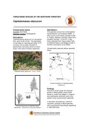
Flora of Conservation Significance<br />
Flora of conservation significance or species meeting a range of criteria (i.e. Data Deficient) as per<br />
the International Union <strong>for</strong> the Conservation of Nature Red List Categories (IUCN, 2001) should be<br />
collected to voucher in the NT Herbarium <strong>and</strong> consequently recorded on the Holtze taxonomic<br />
specimen database.<br />
IUCN categories are listed in Appendix 11. For a list of NT threatened species refer to:<br />
http://www.nt.gov.au/nreta/wildlife/threatened/index.html<br />
Weeds<br />
Weeds of National Significance (WoNS) <strong>and</strong> NT Declared Weeds should be recorded. Weed data<br />
collected should be made available to the Weed Management Branch of NRETA <strong>for</strong> updating the<br />
NT weeds database. Core attributes <strong>and</strong> supplementary data collection sheets have recently been<br />
developed <strong>for</strong> recording weed data in the NT (refer to Appendix 12 <strong>for</strong> directions & Appendix 13 <strong>for</strong><br />
weeds field sheet).<br />
For a list of WoNS refer to:<br />
http://www.weeds.org.au/natsig.htm<br />
For a list of NT Declared Weeds refer to:<br />
http://www.nt.gov.au/nreta/naturalresources/weeds/ntweeds/declared.html<br />
3.2 <strong>Vegetation</strong> Profiles: Stratum Concept<br />
Users find vegetation in<strong>for</strong>mation easier to underst<strong>and</strong> when vegetation communities are portrayed<br />
with simple structural <strong>and</strong> floristic descriptors. While no one classification system will satisfy all<br />
purposes, consensus on describing <strong>and</strong> mapping vegetation favours a system based on:<br />
• structural <strong>for</strong>mation, (eg. growth <strong>for</strong>m: tree, grass etc.);<br />
• height (growth <strong>for</strong>m measured in metres), <strong>and</strong><br />
• cover (percent cover of each growth <strong>for</strong>m).<br />
Northern Territory <strong>Guidelines</strong> <strong>and</strong> <strong>Field</strong> <strong>Methodology</strong><br />
<strong>for</strong> <strong>Vegetation</strong> <strong>Survey</strong> <strong>and</strong> <strong>Mapping</strong><br />
31