Guidelines and Field Methodology for Vegetation Survey and Mapping
Guidelines and Field Methodology for Vegetation Survey and Mapping
Guidelines and Field Methodology for Vegetation Survey and Mapping

You also want an ePaper? Increase the reach of your titles
YUMPU automatically turns print PDFs into web optimized ePapers that Google loves.
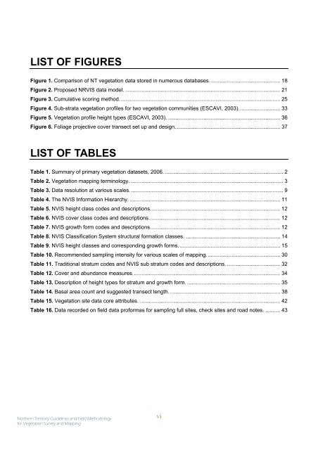
LIST OF FIGURES<br />
Figure 1. Comparison of NT vegetation data stored in numerous databases................................................ 18<br />
Figure 2. Proposed NRVIS data model. ......................................................................................................... 21<br />
Figure 3. Cumulative scoring method............................................................................................................. 25<br />
Figure 4. Sub-strata vegetation profiles <strong>for</strong> two vegetation communities (ESCAVI, 2003). ........................... 33<br />
Figure 5. <strong>Vegetation</strong> profile height types (ESCAVI, 2003). ............................................................................ 36<br />
Figure 6. Foliage projective cover transect set up <strong>and</strong> design. ...................................................................... 37<br />
LIST OF TABLES<br />
Table 1. Summary of primary vegetation datasets, 2006. ................................................................................ 2<br />
Table 2. <strong>Vegetation</strong> mapping terminology. ....................................................................................................... 3<br />
Table 3. Data resolution at various scales. ....................................................................................................... 9<br />
Table 4. The NVIS In<strong>for</strong>mation Hierarchy. ...................................................................................................... 11<br />
Table 5. NVIS height class codes <strong>and</strong> descriptions........................................................................................12<br />
Table 6. NVIS cover class codes <strong>and</strong> descriptions.........................................................................................12<br />
Table 7. NVIS growth <strong>for</strong>m codes <strong>and</strong> descriptions........................................................................................ 12<br />
Table 8. NVIS Classification System structural <strong>for</strong>mation classes. ................................................................ 14<br />
Table 9. NVIS height classes <strong>and</strong> corresponding growth <strong>for</strong>ms. .................................................................... 15<br />
Table 10. Recommended sampling intensity <strong>for</strong> various scales of mapping.................................................. 30<br />
Table 11. Traditional stratum codes <strong>and</strong> NVIS sub stratum codes <strong>and</strong> descriptions. .................................... 32<br />
Table 12. Cover <strong>and</strong> abundance measures....................................................................................................34<br />
Table 13. Description of height types <strong>for</strong> stratum <strong>and</strong> growth <strong>for</strong>m. ............................................................... 35<br />
Table 14. Basal area count <strong>and</strong> suggested transect length............................................................................ 38<br />
Table 15. <strong>Vegetation</strong> site data core attributes. ............................................................................................... 42<br />
Table 16. Data recorded on field data pro<strong>for</strong>mas <strong>for</strong> sampling full sites, check sites <strong>and</strong> road notes. .......... 43<br />
Northern Territory <strong>Guidelines</strong> <strong>and</strong> <strong>Field</strong> <strong>Methodology</strong><br />
<strong>for</strong> <strong>Vegetation</strong> <strong>Survey</strong> <strong>and</strong> <strong>Mapping</strong><br />
vi