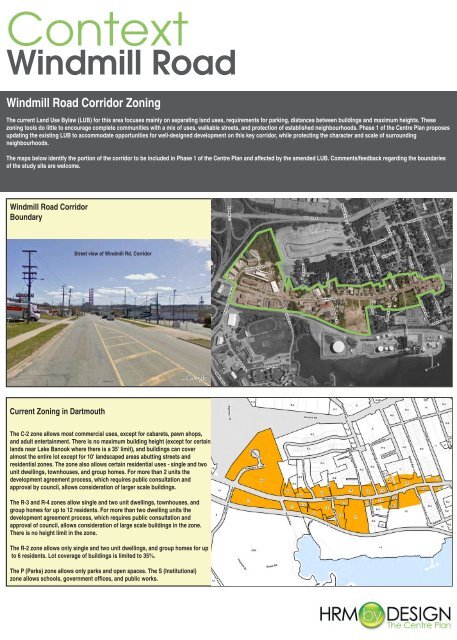
Windmill Road Corridor Zoning
Windmill Road Corridor Zoning
Windmill Road Corridor Zoning

Create successful ePaper yourself
Turn your PDF publications into a flip-book with our unique Google optimized e-Paper software.
Context<br />
<strong>Windmill</strong> <strong>Road</strong><br />
<strong>Windmill</strong> <strong>Road</strong> <strong>Corridor</strong> <strong>Zoning</strong><br />
The current Land Use Bylaw (LUB) for this area focuses mainly on separating land uses, requirements for parking, distances between buildings and maximum heights. These<br />
zoning tools do little to encourage complete communities with a mix of uses, walkable streets, and protection of established neighbourhoods. Phase 1 of the Centre Plan proposes<br />
updating the existing LUB to accommodate opportunities for well-designed development on this key corridor, while protecting the character and scale of surrounding<br />
neighbourhoods.<br />
The maps below identify the portion of the corridor to be included in Phase 1 of the Centre Plan and affected by the amended LUB. Comments/feedback regarding the boundaries<br />
of the study site are welcome.<br />
<strong>Windmill</strong> <strong>Road</strong> <strong>Corridor</strong><br />
Boundary<br />
Street view of <strong>Windmill</strong> Rd. <strong>Corridor</strong><br />
Current <strong>Zoning</strong> in Dartmouth<br />
The C-2 zone allows most commercial uses, except for cabarets, pawn shops,<br />
and adult entertainment. There is no maximum building height (except for certain<br />
lands near Lake Banook where there is a 35' limit), and buildings can cover<br />
almost the entire lot except for 10' landscaped areas abutting streets and<br />
residential zones. The zone also allows certain residential uses - single and two<br />
unit dwellings, townhouses, and group homes. For more than 2 units the<br />
development agreement process, which requires public consultation and<br />
approval by council, allows consideration of larger scale buildings.<br />
The R-3 and R-4 zones allow single and two unit dwellings, townhouses, and<br />
group homes for up to 12 residents. For more than two dwelling units the<br />
development agreement process, which requires public consultation and<br />
approval of council, allows consideration of large scale buildings in the zone.<br />
There is no height limit in the zone.<br />
The R-2 zone allows only single and two unit dwellings, and group homes for up<br />
to 6 residents. Lot coverage of buildings is limited to 35%.<br />
The P (Parks) zone allows only parks and open spaces. The S (Institutional)<br />
zone allows schools, government offices, and public works.
Alternatives<br />
<strong>Windmill</strong> <strong>Road</strong><br />
<strong>Windmill</strong> <strong>Road</strong> <strong>Corridor</strong> Case Study<br />
The case study below compares the existing build form context with the allowable full build-out under current regulations and the possible full build-out under proposed<br />
regulations. The specific site was chosen, as it highlights key attributes of the proposed regulations for its respective corridor.<br />
Existing Build Form Context<br />
Full Build-out Under Current Regulations<br />
Current zoning regulations focus on controlling and separating uses, i.e. commercial, residential and institutional<br />
uses. These regulations may include maximum heights, maximum lot coverage, and minimum requirements for<br />
parking and building setbacks to property lines. However, the existing regulations do little to encourage good<br />
design and only minimally reflect adjacent properties. The lack of design guidelines can result in a building that<br />
overwhelms its site, that does not positively contribute to the pedestrian experience, and which overshadows its<br />
adjacent neighbourhood.<br />
Possible Full Build-out Under Proposed Regulations<br />
The regulations under consideration will encourage mixed use residential and commercial developments along<br />
corridors, which will contribute to the concept of complete and walkable neighbourhoods. In some cases,<br />
maximum proposed heights will be greater than what is allowed under existing regulations. In other cases,<br />
the maximum proposed heights will be less than what is currently allowed. In both cases, however, the proposed<br />
height framework will better reflect the build form context of the existing neighbourhoods, all the while allowing<br />
for economically viable building heights. The maximum height and massing controls which will be applied to each<br />
site will preserve sky views, will ensure a minimum amount of sunlight on sidewalks, and will mitigate against<br />
adverse wind conditions. New design guidelines will result in an aesthetically pleasing architecture and will<br />
ensure a positive pedestrian experience.
Proposed<br />
<strong>Windmill</strong> <strong>Road</strong><br />
Facilitating Development While Protecting Neighbourhood Character<br />
This project proposes to create guidelines that will protect the unique characteristics of this neighbourhood and surrounding streets, while capitalizing on the opportunity to bring<br />
growth and vitality to the community. The guidelines will introduce key design standards to ensure that buildings fit and enhance the neighbourhood. These standards will protect<br />
sunlight and skyview, while controlling wind and shadow. Street wall heights, building heights, stepbacks, setbacks, etc. will respect adjacent properties while allowing for<br />
increased density.<br />
The table and images below describe some of the key design standards proposed for this area. Please share your thoughts on these.<br />
Key Building Variables<br />
<strong>Windmill</strong> Rd.<br />
Section View<br />
A<br />
Building Line<br />
(The line at which a new building<br />
must establish it's Street Wall)<br />
Setback needed to<br />
have 4.5m Sidewalk<br />
(-4.5m )<br />
B<br />
Required Public Way<br />
(distance between facing building<br />
lines)<br />
( 20.8m )<br />
C<br />
D<br />
Max Ht.<br />
Max Street Wall Ht.<br />
(% of distance between facing<br />
Building Lines)<br />
1.25* Public Way<br />
( 26.0m )<br />
80%<br />
( 16.64m )<br />
E<br />
Max Rear Ht.<br />
0.60 * Back Street R.O.W.<br />
( 18.0m )<br />
F<br />
Front Angular Plane<br />
45 degrees from top of<br />
Street Wall<br />
G<br />
Rear Angular Plane<br />
45 degrees from Rear Set<br />
Back at Rear Wall Ht.<br />
NOTE<br />
Design Guidelines<br />
Rules From Downtown<br />
Halifax Design Manual<br />
The proposed design standards reflect<br />
the existing buildings and maintain a<br />
human scale from the street by<br />
permitting a maximum of 4 storeys at the<br />
building front, which could then stepup<br />
to a maximum of 8 storeys.<br />
8 storeys would be the maximum height,<br />
based on the width of <strong>Windmill</strong> Rd.<br />
View Looking South West From <strong>Windmill</strong><br />
View Looking North West from <strong>Windmill</strong><br />
At the rear, the building would again<br />
stepdown to 5 storeys, to ensure that the<br />
existing neighbourhood at the rear is<br />
respected.<br />
View Looking North East From Rear.<br />
View Looking South East From Rear
What Do You Think?<br />
<strong>Windmill</strong> <strong>Road</strong><br />
<strong>Windmill</strong> <strong>Road</strong> <strong>Corridor</strong> Neighbourhood Character<br />
The questions below are intended to help the Centre Plan team determine how residents feel about the proposed building form, and what other design qualities should be<br />
considered to enhance the neighbourhood.<br />
1. Think about a street that you like anywhere in the world. What is it about it that makes<br />
it great?<br />
2. Take a look at the proposed building model for this corridor, does this massing and<br />
scale achieve the goal of densification while still fitting well with the adjacent<br />
neighbourhoods? Do the step-backs and transitions respect adjacent properties?<br />
3. Understanding this is a corridor intended for densification, what should we protect and<br />
enhance? What other design qualities should be considered?<br />
4. Do you have any other comments?