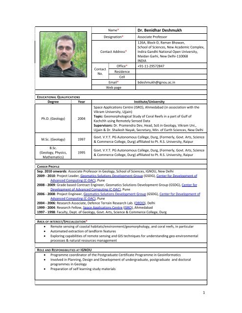
Dr. Benidhar Deshmukh - IGNOU
Dr. Benidhar Deshmukh - IGNOU
Dr. Benidhar Deshmukh - IGNOU

You also want an ePaper? Increase the reach of your titles
YUMPU automatically turns print PDFs into web optimized ePapers that Google loves.
Contact<br />
No.<br />
Name*<br />
Designation*<br />
Contact Address*<br />
<strong>Dr</strong>. <strong>Benidhar</strong> <strong>Deshmukh</strong><br />
Associate Professor<br />
126A, Block‐D, Raman Bhawan,<br />
School of Sciences, New Academic Complex,<br />
Indira Gandhi National Open University,<br />
Maidan Garhi, New Delhi‐110068<br />
INDIA<br />
Office* +91‐11‐29572847<br />
Residence<br />
Cell<br />
Email*<br />
Web page<br />
bdeshmukh@ignou.ac.in<br />
EDUCATIONAL QUALIFICATIONS<br />
Degree Year Institute/University<br />
Ph.D. (Geology) 2004<br />
M.Sc. (Geology) 1997<br />
B.Sc.<br />
(Geology, Physics,<br />
Mathematics)<br />
1995<br />
Space Applications Centre (ISRO), Ahmedabad (in association with the<br />
Vikram University, Ujjain)<br />
Topic: Geomorphological Study of Coral Reefs in a part of Gulf of<br />
Kachchh using Remotely Sensed Data<br />
Supervisors: <strong>Dr</strong>. Pramendra Dev, Head, SoS in Geology, Vikram Uni.,<br />
Ujjain & <strong>Dr</strong>. Shailesh Nayak, Secretary, Min. of Earth Sciences, New Delhi<br />
Govt. V.Y.T. PG Autonomous College, Durg, (Formerly, Govt. Arts, Science<br />
& Commerce College, Durg) affiliated to Pt. R.S. University, Raipur<br />
Govt. V.Y.T. PG Autonomous College, Durg, (Formerly, Govt. Arts, Science<br />
& Commerce College, Durg) affiliated to Pt. R.S. University, Raipur<br />
CAREER PROFILE<br />
Sep. 2010 onwards: Associate Professor in Geology, School of Sciences, <strong>IGNOU</strong>, New Delhi<br />
2009 ‐ 2010: Project Leader, Geomatics Solutions Development Group (GSDG), Center for Development of<br />
Advanced Computing (C‐DAC), Pune<br />
2008 ‐ 2009: Grade based Contract Engineer, Geomatics Solutions Development Group (GSDG), Center for<br />
Development of Advanced Computing (C‐DAC), Pune<br />
2006 ‐ 2008: Project Engineer, Geomatics Solutions Development Group (GSDG), Center for Development of<br />
Advanced Computing (C‐DAC), Pune<br />
2004 ‐ 2006: Research Associate, Defence Terrain Research Lab. (DRDO), Delhi<br />
1999 ‐ 2004: Research Fellow, Space Applications Centre (ISRO), Ahmedabad<br />
1997 ‐ 1998: Faculty, Dept. of Geology, Govt. Arts, Science & Commerce College, Durg<br />
AREA OF INTEREST/SPECIALIZATION*<br />
• Remote sensing of coastal habitats/environment/geomorphology, and coral reefs, in particular<br />
• Automated extraction of landform features<br />
• Exploring capabilities of remote sensing and GIS techniques for understanding geo‐environmental<br />
processes & natural resources management<br />
ROLE AND RESPONSIBILITIES AT <strong>IGNOU</strong><br />
• Programme coordinator of the Postgraduate Certificate Programme in Geoinformatics<br />
• Involved in Planning, Design and Development of undergraduate, postgraduate and doctoral<br />
programmes in Geology<br />
• Preparation of self learning study materials<br />
1
RESEARCH GUIDANCE<br />
Supervision of<br />
Year of<br />
completion<br />
Students Name<br />
Thesis title<br />
Doctoral Students ‐ ‐ ‐<br />
M.Phil. Students ‐ ‐ ‐<br />
M.Sc. Geology 1998 Amit Soni<br />
Geological study of Dalli‐Rajhara<br />
Iron Ore complex and Dongargarh<br />
area, Dist‐Durg, M.P., India<br />
2009<br />
Prioritizing sites for marine<br />
Ushma Shukla &<br />
protected areas using<br />
Manasi Bapat<br />
geoinformatics technology<br />
P.G. Diploma in Geoinformatics<br />
2009<br />
Munna Kumar &<br />
Sapana Chavan<br />
Shoreline change study in<br />
northwest part of Gulf of Kachchh<br />
region using remote sensing data<br />
NUMBER OF PUBLICATIONS (LIST FOR EACH ITEM COULD BE GIVEN UNDER SEPARATE FILES FOR LINKING)<br />
A. Books/Monographs (Authored/Edited)/ Book Chapter/ Lecture Notes :<br />
• <strong>Deshmukh</strong>, B. (2007) Issues confronting remote sensing based change detection of coastal zones,<br />
Chapter 19, Lecture Notes, (Eds: Partheeban, P. and ArunBabu), Advanced Training Program on<br />
Application of GIS, GPS and RS for Disaster Management of Coastal Region. St. Peters College,<br />
Chennai, pp.200‐209.<br />
• Bahuguna, A., Nayak, S. and <strong>Deshmukh</strong>, B. (2005) IRS views the Adams Bridge (bridging India and<br />
SriLanka) Chapter 26, in Remote Sensing and Archaeology, (Editor: A. Tripathi), Sundeep<br />
Publication, New Delhi, 307p.<br />
B. Papers in Refereed/Peer reviewed Journals :<br />
• Roychowdhury, P., <strong>Deshmukh</strong>, B., Prasad, S.S. and Goswami, A. (2011) Neural network based dunal<br />
landform mapping from multispectral images using texture features. IEEE Jour. of Selected Topics in<br />
Applied Earth Observation and Remote Sensing. Vol. 4 No. 1., pp. 171‐184.<br />
DOI:10.1109/JSTARS.2010.2062491.<br />
• <strong>Deshmukh</strong>, B., Bahuguna, A., Nayak, S.R., Jagtap, T.G. and Dhargalkar, V.K. (2005) Ecogeomorphological<br />
zonation of Bangaram atoll, Lakshadweep, Jour. Indian Society of Remote Sensing.<br />
33(1), pp.99‐106 [pdf].<br />
• Shah, D. G., Bahuguna, A., <strong>Deshmukh</strong>, B., Nayak, S. R., Patel, B. H. and Patel, S. (2005) Zoning and<br />
monitoring dominant mangrove communities of a part of the Marine National Park, Gulf of Kachchh.<br />
Jour. Indian Society of Remote Sensing. 33(1), pp.155‐164 [pdf].<br />
• Bahuguna, A., Nayak, S. and <strong>Deshmukh</strong>, B. (2003) IRS views the Adams Bridge (bridging India and<br />
SriLanka), Jour. Indian Society of Remote Sensing. 31(4). pp.237‐239 [pdf].<br />
C. Papers in Conference Proceedings:<br />
• Chavan, S, Kumar, M., and <strong>Deshmukh</strong>, B. (2010) Shoreline change study in northwest part of Gulf<br />
of Kachchh regions using remote sensing data, Proc. National Seminar on Issues in Land Resources<br />
Management: Land Degradation, Climate Change and Land Use Diversification, Nagpur,<br />
(Abstract)<br />
• Johnson, C.P., <strong>Deshmukh</strong>, B. and Kale, M. (2008) Role of GIS and remote Sensing in the<br />
sustainable development of Mauritius, Proc. 10 th GSDI Int. Conf. on Small Island Perspectives on<br />
Global Challenges: The Role of Spatial Data in Supporting a Sustainable Future, St. Augustine,<br />
Trinidad [pdf]<br />
• Roy Chowdhury, P., <strong>Deshmukh</strong>, B. and Goswami, A. (2007) Machine extraction of landforms from<br />
multispectral images using texture and neural methods, ICCTA, pp. 721‐725, Int. Conf. on<br />
Computing: Theory and Applications (ICCTA'07), Kolkata [pdf]<br />
• Panchal, V.K., Saxena, P.C., <strong>Deshmukh</strong>, B., Shaveta, S. (2006) Resolving spectrally similar<br />
landuse/landcover class conflict in remote sensing images using rough sets, ICHIT, pp. 460‐<br />
466, Int. Conf. on Hybrid Information Technology ‐ Vol2 (ICHIT'06), S. Korea [pdf]<br />
• Panchal, V., Gupta, S., Garg, G. and <strong>Deshmukh</strong>, B. (2006) Resolving spectrally similar<br />
landuse/landcover class conflict, Proc. Int. Conf. Map Asia 2006, Bangkok, (Abstract)<br />
2
• Panchal, V., Saini, N., <strong>Deshmukh</strong>, B. and Saxena, P.C. (2006) Granular computing: a rough set<br />
approach. Proc. 9 th Annual Int. Conf. Map India 2006, Delhi, (Abstract) [htm]<br />
• Panchal, V., Saini, N., <strong>Deshmukh</strong>, B. and Saxena, P.C. (2005) Rough Set ‐ a fast mechanism for<br />
accuracy of approximation of landuse/landcover classification accuracy, Presented at the 25 th<br />
ISRS Annual Convention and National Symposium on ‘Emergence of Geoinformatics for<br />
Development: Trends and Opportunities’, Ranchi, (Abstract)<br />
• <strong>Deshmukh</strong>, B., Nayak, S., Bahuguna, A. and Dev, P. (2005) Study of suspended sediment dispersal<br />
patterns in the Gulf of Kachchh with reference to coral reefs. Proc. 8 th Annual Int. Conf. Map India<br />
2005, Delhi [pdf]<br />
• Prusty, G., Kumar, M., Sejwal, S., <strong>Deshmukh</strong>, B. (2004) Mangrove wetland dynamics<br />
characterisation based on remote sensing inputs: Gahirmatha (Orissa). Proc. Annual Symposium<br />
of Indian Institute of Geomorphologists, Pune (Abstract)<br />
• Bahuguna, A., Nayak, S., <strong>Deshmukh</strong>, B., Shah, D.G. and Patel, B.H. (2002) Management of vital<br />
coastal habitats of Gulf of Kachchh: an input from remote sensing data. Proc. International<br />
Society for Photogrammetry and Remote Sensing (ISPRS) Symposium on Resource and<br />
Environmental Monitoring, Part 7, Commission VII, Hyderabad, India. v.34, pp.403‐408<br />
• <strong>Deshmukh</strong>, B., Bahuguna, A., Nayak, S.R., Dhargalkar, V.K. and Jagtap, T.G. (2001) Ecogeomorphological<br />
zonation of Bangaram atoll, Lakshadweep. Proc. ‘National Symposium on<br />
Advances in Remote Sensing Technology with Special Emphasis on High Resolution Imagery’, ISRS,<br />
Ahmedabad, India, (CD‐ROM Volume)<br />
• Shah, D. G., Bahuguna, A., <strong>Deshmukh</strong>, B., Nayak, S. R., Patel, B. H. and Patel, S. (2001) Zoning and<br />
monitoring dominant mangrove communities of a part of the Marine National Park, Gulf of<br />
Kachchh. Proc. ‘National Symposium on Advances in Remote Sensing Technology with Special<br />
Emphasis on High Resolution Imagery’, ISRS, Ahmedabad, India, (CD‐ROM Volume) [pdf]<br />
• Bahuguna, A., <strong>Deshmukh</strong>, B., Nayak, S. and Patel, B.H. (2000) Coral reefs of the Gulf of Kachchh:<br />
their present status and eco‐geomorphological zonation using high resolution satellite data.<br />
Paper presented in Fifth Pacific Ocean Remote Sensing Conference (PORSEC), Goa, India,<br />
(Abstract)<br />
D. Scientific/Technical Notes:<br />
• Prusty, G., Kalra, M.K. and <strong>Deshmukh</strong>, B. (2005) Coastal erosion assessment of Outer Wheeler<br />
Island (OWI), Technical Note, Defence Terrain Research Laboratory (DRDO), Delhi,<br />
DTRL/2005/Geo‐Environment/10, 21p.<br />
• Nayak, S., Bahuguna, A., <strong>Deshmukh</strong>, B., Shah, D.G., Rao, R.S., Dhargalkar, V.K., Jagtap, T.G.,<br />
Komarpant, D.S., Branganza, C., Venkataraman, K., Sounderarajan, R., Singh, H.S., Pandey, C.N.,<br />
Patel, B.H. and Prasanna, Y.L. (2003) Eco‐morphological zonation of selected coral reefs of India<br />
using remotely sensed data. Scientific Note, Space Applications Centre (ISRO), Ahmedabad,<br />
SAC/RESIPA/MWRG/MSCED/SN/16/2003, 109p.<br />
CONFERENCES/SEMINARS/WORKSHOPS ORGANISED/PARTICIPATED<br />
A. Conferences/Seminars/Workshops organised<br />
B. Conferences/Seminars/Workshops participated/Presented<br />
• <strong>Deshmukh</strong>, B., Prusty, G., Khumukcham, L. and Mohapatra, S.N. (2006) Issues surrounding remote<br />
sensing based monitoring of coastal ecosystems: a case study of tsunami affected Andaman and<br />
Nicobar islands. Proc. 9 th Annual Int. Conf. Map India 2006, Delhi [htm]<br />
• <strong>Deshmukh</strong>, B., Bahuguna, A., Nayak, S.R., Dhargalkar, V.K. and Jagtap, T.G. (2001) Ecogeomorphological<br />
zonation of Bangaram atoll, Lakshadweep. Proc. ‘National Symposium on Advances<br />
in Remote Sensing Technology with Special Emphasis on High Resolution Imagery’, ISRS, Ahmedabad,<br />
India.<br />
• <strong>Deshmukh</strong>, B., Shah, D.G., Prasanna, Y., Bahuguna, A., Nayak, S. and Patel, B.H. (2000) Discrimination<br />
of coral reef zones using remote sensing technique: a study of Narara island, Gulf of Kachchh. Paper<br />
presented in ISRS Symposium on ‘Spatial Technologies for Natural Hazards Management’, IIT, Kanpur,<br />
India.<br />
• Attended one week Induction programme Induction programme on ‘Distance Education: Theory and<br />
3
Practice’ Conducted by Staff Training and Research institute of Distance Education, <strong>IGNOU</strong>, New Delhi<br />
in October 2010.<br />
• Attended one week DST sponsored training on Imaging Spectroscopy at IIT Bombay in December<br />
2008.<br />
• Attended one week ISRO sponsored training on Microwave Remote Sensing at IIRS, Dehradun in<br />
2007.<br />
• Attended 5 day workshop on Technical Writing organised by CrackerJack WordSmiths, Pune in 2007.<br />
• Assisted in conducting two courses under Continuing Education Programme (CEP) on Recent<br />
Advances in Remote Sensing, GPS and GIS at DTRL, Delhi and also served as Faculty during 2005‐2006.<br />
• Assisted in conducting various training programmes and imparted training to scientific personnel and<br />
officials of five Indian (Govt.) agencies on application of remote sensing data for coastal habitat<br />
studies at the Space Applications Centre, Ahmedabad, India during 2002‐2004.<br />
• Organised and participated in a workshop on Application of Remote Sensing and GIS for Coastal<br />
Habitats of India held at the Space Applications Centre, Ahmedabad, on 14th Nov. 2002.<br />
• Participated as faculty and assisted in organisation of the workshop on Commercial Application of<br />
Remote Sensing and GIS with special emphasis to coastal zone management (CARG) during October,<br />
2000.<br />
RESEARCH PROJECTS<br />
Sponsoring Agency<br />
Department of Space,<br />
Govt of India, National<br />
Remote Sensing<br />
Agency (NRSA),<br />
Hyderabad<br />
Period<br />
2008 ‐<br />
2010<br />
Amount of<br />
grant<br />
(in Lakhs)<br />
31<br />
Title of Project<br />
Land Degradation Mapping of<br />
Bihar state using Multitemporal<br />
data<br />
(under the Natural Resources<br />
Census Programme)<br />
Co‐investigator(s)<br />
(if any)<br />
HONOURS/AWARDS/DISTINCTIONS<br />
Awards:<br />
2006: Best technical paper presentation at 9 th Int. Conference (Map India 2006), Delhi.<br />
1997: First rank in University merit list in M.Sc. Geology.<br />
1998: Awarded ‘C’ certificate of National Service Scheme.<br />
Fellowship/Scholarship:<br />
2004‐2006: Research Associateship by Defence R&D Organisation, Delhi.<br />
1999‐2004: Research Fellowship by Space Applications Centre (ISRO), Ahmedabad.<br />
Invited Lectures:<br />
August 2010: Delivered lectures on RS & GIS applications for coastal ecosystem studies, MSc. Geoinformatics,<br />
BVIEER, Bharti Vidyapeeth, Pune.<br />
2010 & 2008: Delivered lecture on Basics of remote sensing and its application for geological studies to B.Sc. &<br />
M.Sc. Geology students at Govt. VYT PG Autonomous College, Durg.<br />
2008: Delivered invited talk on Application of remote sensing and GIS for Geological applications, Govt. VYT PG<br />
Autonomous College, Durg.<br />
2007: Delivered invited lectures on Issues confronting remote sensing based change detection of coastal<br />
zones, in DST sponsored Advanced Training Program on Application of GIS, GPS and RS for Disaster<br />
Management of Coastal Region at St. Peters College, Chennai.<br />
Review Service:<br />
Journal of Geomorphology (Elsevier)<br />
Applied Remote Sensing (Academy)<br />
Trends in Soil Sciences and Plant Nutritions (Academy)<br />
4
PROFESSIONAL ASSOCIATIONS<br />
Life Member, Indian Society of Remote Sensing<br />
Life Member, Indian Society of Geomatics<br />
Fellow, Society of Earth Scientists<br />
OTHER ACTIVITIES<br />
‣ Organized field trip and collected field data from parts of Karnataka for remote sensing based iron ore<br />
mapping in 2009<br />
‣ Received training on Erdas LPS Photogrammetry s/w from Leica Inc. in July 2009.<br />
‣ Received training on GeoMedia Professional and GeoMedia Grid ver. 5.1 from Rolta Inc. in 2005.<br />
‣ Organised and collected field data from all the major coral reef regions of India, i.e. Gulf of Kachchh, Gulf<br />
of Mannar, Andaman and Nicobar and Lakshadweep archipelago during 1999‐2003.<br />
‣ Obtained ‘A’, ‘B’ and ‘C’ certificates of National Service Scheme through active participation in the social<br />
service during school and college periods.<br />
‣ Obtained field training on prospecting, exploration, mining methods and estimation of ore reserves from<br />
Dalli‐Rajhara Iron Ore Complex, Bhilai Steel Plant, Steel Authority of India Limited.<br />
‣ Participated in various community service activities (such as awareness programmes on Earthquakes,<br />
conducting children competition and plantation) organised by Indian Society of Remote Sensing,<br />
Ahmedabad Chapter.<br />
‣ Participated and received prizes in general knowledge, essay writing, debate and play competitions during<br />
school, college, etc.<br />
‣ Conducted literacy classes along with two friends for beggars and leprosy affected people of Durg city,<br />
Chhattisgarh, India during higher secondary schooling.<br />
5