Buck Island Reef National Monument Geologic Resources Inventory
Buck Island Reef National Monument Geologic Resources Inventory
Buck Island Reef National Monument Geologic Resources Inventory

You also want an ePaper? Increase the reach of your titles
YUMPU automatically turns print PDFs into web optimized ePapers that Google loves.
<strong>National</strong> Park Service<br />
U.S. Department of the Interior<br />
Natural Resource Stewardship and Science<br />
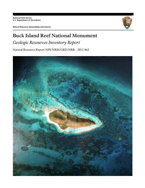
<strong>Buck</strong> <strong>Island</strong> <strong>Reef</strong> <strong>National</strong> <strong>Monument</strong><br />
<strong>Geologic</strong> <strong>Resources</strong> <strong>Inventory</strong> Report<br />
Natural Resource Report NPS/NRSS/GRD/NRR—2011/462
ON THE COVER<br />
Aerial photograph of <strong>Buck</strong> <strong>Island</strong> <strong>Reef</strong> <strong>National</strong> <strong>Monument</strong>.<br />
<strong>National</strong> Park Service photograph.<br />
THIS PAGE<br />
Patch reefs called “haystacks” off the north side of <strong>Buck</strong> <strong>Island</strong> <strong>Reef</strong> lagoon and beyond the barrier reef.<br />
Photograph by Zandy Hillis-Starr (St. Croix and <strong>Buck</strong> <strong>Island</strong> NPS areas).
<strong>Buck</strong> <strong>Island</strong> <strong>Reef</strong> <strong>National</strong> <strong>Monument</strong><br />
<strong>Geologic</strong> <strong>Resources</strong> <strong>Inventory</strong> Report<br />
Natural Resource Report NPS/NRSS/GRD/NRR—2011/462<br />
<strong>National</strong> Park Service<br />
<strong>Geologic</strong> <strong>Resources</strong> Division<br />
PO Box 25287<br />
Denver, CO 80225<br />
November 2011<br />
U.S. Department of the Interior<br />
<strong>National</strong> Park Service<br />
Natural Resource Stewardship and Science<br />
Fort Collins, Colorado
The <strong>National</strong> Park Service, Natural Resource Stewardship and Science office in Fort<br />
Collins, Colorado publishes a range of reports that address natural resource topics of<br />
interest and applicability to a broad audience in the <strong>National</strong> Park Service and others in<br />
natural resource management, including scientists, conservation and environmental<br />
constituencies, and the public.<br />
The Natural Resource Report Series is used to disseminate high-priority, current natural<br />
resource management information with managerial application. The series targets a<br />
general, diverse audience, and may contain NPS policy considerations or address<br />
sensitive issues of management applicability.<br />
All manuscripts in the series receive the appropriate level of peer review to ensure that<br />
the information is scientifically credible, technically accurate, appropriately written for<br />
the intended audience, and designed and published in a professional manner. This<br />
report received informal peer review by subject-matter experts who were not directly<br />
involved in the collection, analysis, or reporting of the data.<br />
Views, statements, findings, conclusions, recommendations, and data in this report do<br />
not necessarily reflect views and policies of the <strong>National</strong> Park Service, U.S. Department<br />
of the Interior. Mention of trade names or commercial products does not constitute<br />
endorsement or recommendation for use by the U.S. Government.<br />
Printed copies of this report are produced in a limited quantity and they are only<br />
available as long as the supply lasts. This report is available from the <strong>Geologic</strong> <strong>Resources</strong><br />
<strong>Inventory</strong> website (http://www.nature.nps.gov/geology/inventory/<br />
gre_publications.cfm) and the Natural Resource Publications Management website<br />
(http://www.nature.nps.gov/publications/nrpm/).<br />
Please cite this publication as follows:<br />
KellerLynn, K. 2011. <strong>Buck</strong> <strong>Island</strong> <strong>Reef</strong> <strong>National</strong> <strong>Monument</strong>: geologic resources<br />
inventory report. Natural Resource Report NPS/NRSS/GRD/NRR—2011/462.<br />
<strong>National</strong> Park Service, Fort Collins, Colorado.<br />
NPS 163/111477, November 2011<br />
ii NPS <strong>Geologic</strong> <strong>Resources</strong> Division
Contents<br />
List of Figures ................................................................................................................ iv<br />
List of Tables ................................................................................................................. iv<br />
Executive Summary ....................................................................................................... v<br />
Acknowledgements ...................................................................................................... vi<br />
Credits ........................................................................................................................................................................ vi<br />
Introduction ................................................................................................................... 1<br />
Purpose of the <strong>Geologic</strong> <strong>Resources</strong> <strong>Inventory</strong> ............................................................................................................... 1<br />
Establishment of <strong>Buck</strong> <strong>Island</strong> <strong>Reef</strong> <strong>National</strong> <strong>Monument</strong> ................................................................................................. 1<br />
Regional Information ................................................................................................................................................... 1<br />
<strong>Geologic</strong> Setting .......................................................................................................................................................... 2<br />
<strong>Geologic</strong> Issues .............................................................................................................. 7<br />
Oceanographic and Meteorological Variables ............................................................................................................... 7<br />
Sea Level Rise............................................................................................................................................................... 9<br />
Sediment Characteristics and Distribution ..................................................................................................................... 9<br />
Erosion ...................................................................................................................................................................... 10<br />
Windblown Particulates ............................................................................................................................................. 10<br />
Seismic Activity .......................................................................................................................................................... 11<br />
Hurricanes ................................................................................................................................................................. 11<br />
<strong>Geologic</strong> Features and Processes ................................................................................ 19<br />
Caledonia Formation .................................................................................................................................................. 19<br />
Benthic Habitats ......................................................................................................................................................... 19<br />
<strong>Reef</strong>s ......................................................................................................................................................................... 19<br />
Seagrass Beds ............................................................................................................................................................ 22<br />
Paleontological <strong>Resources</strong> .......................................................................................................................................... 22<br />
<strong>Geologic</strong> History .......................................................................................................... 27<br />
Upper Cretaceous Period: <strong>Island</strong>-Arc Setting ............................................................................................................... 27<br />
Miocene and Pliocene Epochs: Deep-Marine Rocks to Shoaling in the Basin ................................................................ 27<br />
Pliocene and Pleistocene Epochs: Development of <strong>Reef</strong>s around St. Croix ................................................................... 28<br />
Pleistocene and Holocene Epochs: <strong>Reef</strong> Formation around <strong>Buck</strong> <strong>Island</strong> ........................................................................ 28<br />
<strong>Geologic</strong> Map Data ...................................................................................................... 33<br />
<strong>Geologic</strong> Maps ........................................................................................................................................................... 33<br />
Source Maps .............................................................................................................................................................. 33<br />
<strong>Geologic</strong> GIS Data ...................................................................................................................................................... 33<br />
<strong>Geologic</strong> Map Overview ............................................................................................................................................. 34<br />
Map Unit Properties Table .......................................................................................................................................... 34<br />
Use Constraints .......................................................................................................................................................... 34<br />
<strong>Geologic</strong> Map Overview Graphics .............................................................................. 35<br />
Map Unit Properties Table .......................................................................................... 37<br />
Glossary ........................................................................................................................ 43<br />
Literature Cited ............................................................................................................ 47<br />
Additional References ................................................................................................. 53<br />
Appendix: Scoping Session Participants .................................................................... 54<br />
Attachment 1: <strong>Geologic</strong> <strong>Resources</strong> <strong>Inventory</strong> Products CD<br />
BUIS <strong>Geologic</strong> <strong>Resources</strong> <strong>Inventory</strong> Report iii
List of Figures<br />
Figure 1. Boundary expansion. ..................................................................................................................................... 2<br />
Figure 2. Location map for <strong>Buck</strong> <strong>Island</strong> <strong>Reef</strong> <strong>National</strong> <strong>Monument</strong>.................................................................................. 3<br />
Figure 3. Composite aerial photograph for the main island of St. Croix, U.S. Virgin <strong>Island</strong>s ............................................ 4<br />
Figure 4. Elkhorn coral ................................................................................................................................................. 4<br />
Figure 5. Haystacks ...................................................................................................................................................... 5<br />
Figure 6. Major oceanographic currents ..................................................................................................................... 14<br />
Figure 7. Coastal Vulnerability Index (CVI) for Virgin <strong>Island</strong>s <strong>National</strong> Park ................................................................... 14<br />
Figure 8. Sediment transport at <strong>Buck</strong> <strong>Island</strong> <strong>Reef</strong> <strong>National</strong> <strong>Monument</strong> ........................................................................ 15<br />
Figure 9. Seasonal sedimentation pattern. .................................................................................................................. 15<br />
Figure 10. Beach sand at Turtle Bay ............................................................................................................................ 16<br />
Figure 11. Seismicity map of the Caribbean ................................................................................................................ 16<br />
Figure 12. Tectonic map of the Caribbean plate .......................................................................................................... 17<br />
Figure 13. South reef before and after Hurricane Hugo .............................................................................................. 18<br />
Figure 14. Caledonia Formation .................................................................................................................................. 23<br />
Figure 15. Uncolonized and colonized bedrock ........................................................................................................... 24<br />
Figure 16. Colonized pavement .................................................................................................................................. 24<br />
Figure 17. Seagrass. ................................................................................................................................................... 24<br />
Figure 18. Linear reef ................................................................................................................................................. 25<br />
Figure 19. Aggregated patch reef ............................................................................................................................... 25<br />
Figure 20. Scattered coral or rock in unconsolidated sediment .................................................................................... 26<br />
Figure 21. Elkhorn coral ............................................................................................................................................. 26<br />
Figure 22. Generalized geology of St. Croix ................................................................................................................ 29<br />
Figure 23. <strong>Reef</strong> development around <strong>Buck</strong> <strong>Island</strong>. ....................................................................................................... 30<br />
Figure 24. <strong>Geologic</strong> timescale..................................................................................................................................... 31<br />
List of Tables<br />
Table 1. Storm history at <strong>Buck</strong> <strong>Island</strong> <strong>Reef</strong> <strong>National</strong> <strong>Monument</strong> from 1979 to 2008 .................................................... 18<br />
Table 2. Controls and distribution of reef crest ........................................................................................................... 18<br />
Table 3. Geology data layers in the <strong>Buck</strong> <strong>Island</strong> <strong>Reef</strong> <strong>National</strong> <strong>Monument</strong> GIS data ..................................................... 34<br />
iv NPS <strong>Geologic</strong> <strong>Resources</strong> Division
Executive Summary<br />
This report accompanies the digital geologic map data for <strong>Buck</strong> <strong>Island</strong> <strong>Reef</strong> <strong>National</strong><br />
<strong>Monument</strong> in U.S. Virgin <strong>Island</strong>s, produced by the <strong>Geologic</strong> <strong>Resources</strong> Division in<br />
collaboration with its partners. It contains information relevant to resource management<br />
and scientific research. This document incorporates preexisting geologic information and<br />
does not include new data or additional fieldwork by the <strong>Geologic</strong> <strong>Resources</strong> Division.<br />
<strong>Buck</strong> <strong>Island</strong> <strong>Reef</strong> <strong>National</strong> <strong>Monument</strong> is a jewel of the<br />
<strong>National</strong> Park System because of its beauty and<br />
accessibility (Bush 2009). The national monument<br />
features an emergent linear reef with some of the finest<br />
coral gardens in the Caribbean. Its interpretive<br />
snorkeling trail, the “underwater trail,” provides an<br />
uncommon opportunity for discovery of a submerged,<br />
offshore world. The reef began developing on a<br />
preexisting carbonate platform during lower sea level<br />
about 7,700 years ago (Hubbard et al. 2005). The modern<br />
reef is dominated by the threatened elkhorn coral<br />
(Acropora palmata) (Bythell et al. 1989).<br />
In 2006, the <strong>Geologic</strong> <strong>Resources</strong> <strong>Inventory</strong> (GRI)<br />
Program completed a digital geologic map for <strong>Buck</strong><br />
<strong>Island</strong> <strong>Reef</strong> <strong>National</strong> <strong>Monument</strong>, which includes both<br />
geologic and benthic-habitat units. Sources of these data<br />
are Whetten (1966) and Kendall et al. (1999). As part of<br />
this report, an overview graphic illustrates these data. In<br />
addition, a map unit properties table summarizes the<br />
main features, characteristics, and potential management<br />
issues for each map unit (see “<strong>Geologic</strong> Map Data” and<br />
Attachment 1).<br />
Guided by the priorities identified in the GRI scoping<br />
summary for <strong>Buck</strong> <strong>Island</strong> <strong>Reef</strong> <strong>National</strong> <strong>Monument</strong> (Hall<br />
2005), this report discusses the following issues, features,<br />
and processes as significant for resource management:<br />
• Oceanographic and Meteorological Variables. At <strong>Buck</strong><br />
<strong>Island</strong> <strong>Reef</strong> <strong>National</strong> <strong>Monument</strong>, these variables<br />
include winds, waves, currents, tides, seawater<br />
temperature, and rainfall.<br />
• Sea Level Rise. Sea level rise is a significant issue for<br />
coastal processes and the sustainability of coral reefs<br />
and other habitats at <strong>Buck</strong> <strong>Island</strong> <strong>Reef</strong> <strong>National</strong><br />
<strong>Monument</strong>. Future sea level rise also will affect<br />
recreational activities by impacting beaches and the<br />
underwater trail.<br />
• Sediment Characteristics and Distribution. The digital<br />
geologic map data for the national monument include<br />
surficial deposits and unconsolidated sediments.<br />
Whetten (1966) identified the surficial deposits (map<br />
unit symbol Qal) as sand, beach rock, and stream<br />
deposits, and also referred to these materials as<br />
“alluvium.” Kendall et al. (1999) mapped<br />
unconsolidated sediments, including sand (s) and mud<br />
(mu). Information about sediment characteristics and<br />
distribution is useful for park management for a variety<br />
of reasons, including buoy placement and<br />
maintenance, boat anchoring, and identifying<br />
erosional hot spots.<br />
• Erosion. Heavy rainfall results in runoff, erosion, and<br />
sedimentation. These processes are a concern for<br />
managers at the national monument because of the<br />
maintenance and sustainability of terrestrial trails and<br />
the viability of coral reef communities.<br />
• Windblown Particulates. Dust storms traveling across<br />
the Atlantic Ocean transport windblown particulates<br />
from western Africa into the Caribbean basin.<br />
Scientists hypothesize that African dust carries viable<br />
microorganisms, including pathogens, nutrients such<br />
as iron, persistent organic pollutants, and metals across<br />
oceans, and that these contaminants play a role in the<br />
degradation of downwind ecosystems, including<br />
Caribbean coral reefs (Shinn et al. 2000; Garrison et al.<br />
2003). However, no direct or causal link has yet been<br />
proven (Garrison et al. 2006). Data compiled from<br />
2001–2008 and recently processed may help answer<br />
questions regarding the effects of African dust on coral<br />
reefs of the Caribbean, as well as human health<br />
(Garrison et al. 2011). However, interpretations and<br />
conclusions have yet to be reported from these data.<br />
• Seismic Activity. The Caribbean is a seismically active<br />
region with periodic earthquakes, submarine slides,<br />
submarine volcanic eruptions, subaerial pyroclastic<br />
flows, and tsunamis. The location of <strong>Buck</strong> <strong>Island</strong> <strong>Reef</strong>,<br />
off the northeast coast of St. Croix, and between the<br />
Greater and Lesser Antilles, is an important tectonic<br />
position in the Caribbean region. It marks a transition<br />
from transform (strike-slip) to convergent<br />
(subduction) plate motion. The U.S. <strong>Geologic</strong>al Survey<br />
monitors seismic activity in the U.S. Virgin <strong>Island</strong>s at a<br />
seismic station in Puerto Rico.<br />
• Hurricanes. Hurricanes affect both marine and<br />
terrestrial resources in both positive and negative ways<br />
at the national monument. Scouring and pounding<br />
from storm waves can reduce reefs to pavement and<br />
rubble. Swells and surging can undercut and<br />
temporarily alter beach dynamics and result in<br />
deposition of sediment on fragile coral populations.<br />
Changes in the landscape and beach profiles can affect<br />
nesting turtles. Flooding associated with storm surge<br />
can be extensive. Hurricane-force winds can destroy<br />
physical facilities. Positive aspects of storms include<br />
the rapid recycling of nutrients and the removal of<br />
excess sediment that could otherwise overwhelm a<br />
reef system.<br />
BUIS <strong>Geologic</strong> <strong>Resources</strong> <strong>Inventory</strong> Report v
• Paleontological <strong>Resources</strong>. Toscano et al. (2010)<br />
completed a paleontological resource inventory and<br />
monitoring report for the South Florida/Caribbean<br />
Network, including <strong>Buck</strong> <strong>Island</strong> <strong>Reef</strong> <strong>National</strong><br />
<strong>Monument</strong>. Within the monument, fossils are known<br />
only from the reefs. However, <strong>Buck</strong> <strong>Island</strong> itself is<br />
composed of the Caledonia Formation (map unit<br />
symbol Kc), which is known to host fossils elsewhere.<br />
Future field investigations on <strong>Buck</strong> <strong>Island</strong> could<br />
recover fossils from the Upper Cretaceous Period<br />
(99.6 million to 65.5 million years ago).<br />
• <strong>Reef</strong>s. <strong>Buck</strong> <strong>Island</strong> <strong>Reef</strong> <strong>National</strong> <strong>Monument</strong> is noted<br />
for its reef system. Impacts to reefs include hurricane<br />
damage, bleaching, disease, predation, and damage as a<br />
result of recreational activities.<br />
This GRI report is written for resource managers, to<br />
assist in resource management and science-based<br />
decision making, but it also may be useful for<br />
interpretation. The report discusses distinctive geologic<br />
features and processes within the national monument<br />
and the geologic history leading to the national<br />
monument’s present-day island and reef system. This<br />
report also provides a glossary, which contains<br />
explanations of technical and geologic terms, including<br />
terms on the map unit properties table. Additionally, a<br />
geologic timescale shows the chronologic arrangement<br />
of major geologic events, with the oldest events and time<br />
units at the bottom and the youngest at the top. The<br />
timescale is organized using formally accepted geologictime<br />
subdivisions and ages (fig. 24).<br />
Acknowledgements<br />
The <strong>Geologic</strong> <strong>Resources</strong> <strong>Inventory</strong> (GRI) is one of 12 inventories funded by the <strong>National</strong><br />
Park Service <strong>Inventory</strong> and Monitoring Program. The GRI is administered by the<br />
<strong>Geologic</strong> <strong>Resources</strong> Division of the Natural Resource Stewardship and Science<br />
Directorate.<br />
The <strong>Geologic</strong> <strong>Resources</strong> Division relies heavily on<br />
partnerships with institutions such as the U.S. <strong>Geologic</strong>al<br />
Survey, state geologic surveys, local museums, Colorado<br />
State University, and other universities in developing<br />
GRI products.<br />
The GRI Program would like to thank Kim N. Hall, who<br />
prepared the scoping summary in 2005, and Zandy<br />
Hillis-Starr (Christiansted <strong>National</strong> Historic Site/<strong>Buck</strong><br />
<strong>Island</strong> <strong>Reef</strong> <strong>National</strong> <strong>Monument</strong>/Salt River Bay <strong>National</strong><br />
Historical Park and Ecological Preserve), Alyse Getty<br />
(Parsons Corporation), and Drew Getty (Parsons<br />
Corporation) for their input and guidance. Also, thanks<br />
to Trista Thornberry-Ehrlich (Colorado State<br />
University) for her assistance with the development of<br />
figures, and Zandy Hillis-Starr for providing many<br />
photographs used in this report.<br />
Credits<br />
Author<br />
Katie KellerLynn (Colorado State University)<br />
Review<br />
Dennis Hubbard (Oberlin College)<br />
Zandy Hillis-Starr (St. Croix and <strong>Buck</strong> <strong>Island</strong> NPS areas)<br />
Jason Kenworthy (NPS <strong>Geologic</strong> <strong>Resources</strong> Division)<br />
Editing<br />
Jeff Matthews (Write Science Right)<br />
Digital <strong>Geologic</strong> Data Production<br />
Georgia Hybels (NPS <strong>Geologic</strong> <strong>Resources</strong> Division)<br />
Heather Stanton (Colorado State University)<br />
Digital <strong>Geologic</strong> Data Overview Layout Design<br />
Philip Reiker (NPS <strong>Geologic</strong> <strong>Resources</strong> Division)<br />
vi NPS <strong>Geologic</strong> <strong>Resources</strong> Division
Introduction<br />
The following section briefly describes the <strong>National</strong> Park Service <strong>Geologic</strong> <strong>Resources</strong><br />
<strong>Inventory</strong> and the regional geologic setting of <strong>Buck</strong> <strong>Island</strong> <strong>Reef</strong> <strong>National</strong> <strong>Monument</strong>.<br />
Purpose of the <strong>Geologic</strong> <strong>Resources</strong> <strong>Inventory</strong><br />
The <strong>Geologic</strong> <strong>Resources</strong> <strong>Inventory</strong> (GRI) is one of 12<br />
inventories funded by the <strong>National</strong> Park Service (NPS)<br />
<strong>Inventory</strong> and Monitoring Program. The GRI,<br />
administered by the <strong>Geologic</strong> <strong>Resources</strong> Division of the<br />
Natural Resource Stewardship and Science Directorate,<br />
is designed to provide and enhance baseline information<br />
available to park managers. The GRI team relies heavily<br />
on partnerships with institutions such as the U.S.<br />
<strong>Geologic</strong>al Survey, Colorado State University, state<br />
geologic surveys, local museums, and universities in<br />
developing GRI products.<br />
The goals of the GRI are to increase understanding of the<br />
geologic processes at work in parks and to provide sound<br />
geologic information for use in park decision making.<br />
Sound park stewardship requires an understanding of<br />
the natural resources and their role in the ecosystem.<br />
Park ecosystems are fundamentally shaped by geology.<br />
The compilation and use of natural resource information<br />
by park managers is called for in section 204 of the<br />
<strong>National</strong> Parks Omnibus Management Act of 1998 and in<br />
NPS-75, Natural <strong>Resources</strong> <strong>Inventory</strong> and Monitoring<br />
Guideline.<br />
To realize these goals, the GRI team is systematically<br />
conducting a scoping meeting for each of the 270<br />
identified natural area parks and providing a parkspecific<br />
digital geologic map and geologic report. These<br />
products support the stewardship of park resources and<br />
are designed for non-geoscientists. Scoping meetings<br />
bring together park staff and geologic experts to review<br />
available geologic maps and discuss specific geologic<br />
issues, features, and processes.<br />
The GRI mapping team converts the geologic maps<br />
identified for park use at the scoping meeting into digital<br />
geologic data in accordance with their Geographic<br />
Information Systems (GIS) Data Model. These digital<br />
data sets bring an interactive dimension to traditional<br />
paper maps. The digital data sets provide geologic data<br />
for use in park GIS and facilitate the incorporation of<br />
geologic considerations into a wide range of resource<br />
management applications. The newest maps contain<br />
interactive help files. This geologic report assists park<br />
managers in the use of the map and provides an overview<br />
of park geology and geologic resource management<br />
issues.<br />
For additional information regarding the content of this<br />
report and current GRI contact information please refer<br />
to the <strong>Geologic</strong> <strong>Resources</strong> <strong>Inventory</strong> website<br />
(http://www.nature.nps.gov/geology/inventory/).<br />
Establishment of <strong>Buck</strong> <strong>Island</strong> <strong>Reef</strong> <strong>National</strong> <strong>Monument</strong><br />
Established by John F. Kennedy in 1961, <strong>Buck</strong> <strong>Island</strong><br />
<strong>Reef</strong> <strong>National</strong> <strong>Monument</strong> preserves “one of the finest<br />
marine gardens in the Caribbean Sea” (Presidential<br />
Proclamation 3443). In 1975, Gerald Ford (Presidential<br />
Proclamation 4346) slightly modified the boundaries,<br />
adding 12 ha (30 ac) of marine habitat. In 2001, the<br />
national monument was greatly expanded to 7,695 ha<br />
(19,015 ac) by Bill Clinton under Presidential<br />
Proclamation 7392 (fig. 1). At the same time, new<br />
regulations were enacted making the entire monument a<br />
no-take and “restricted anchoring” zone (Pittman et al.<br />
2008). The national monument is now one of only a few<br />
fully marine protected areas in the <strong>National</strong> Park System.<br />
Regional Information<br />
<strong>Buck</strong> <strong>Island</strong> <strong>Reef</strong> <strong>National</strong> <strong>Monument</strong> is part of the U.S.<br />
Virgin <strong>Island</strong>s and situated in the Caribbean Sea (fig. 2).<br />
<strong>Buck</strong> <strong>Island</strong> <strong>Reef</strong> is 2.4 km (1.5 mi) off the northeastern<br />
shore of St. Croix, which is the largest of the U.S. Virgin<br />
<strong>Island</strong>s (fig. 3). <strong>Buck</strong> <strong>Island</strong> Channel separates St. Croix<br />
and <strong>Buck</strong> <strong>Island</strong>. The island rises in a single east-west<br />
ridge to an elevation of 104 m (340 ft) above sea level. It is<br />
1,830 m (6,000 ft) long and 670 m (2,200 ft) wide at its<br />
widest point. Most of the island consists of steep slopes,<br />
90% of which are steeper than 30%. There are two fairly<br />
level areas with sandy beaches—Diedrichs Point on the<br />
south side of <strong>Buck</strong> <strong>Island</strong>, and West Beach on the<br />
western end of the island.<br />
<strong>Buck</strong> <strong>Island</strong> and the surrounding coral reef system<br />
support a large variety of native flora and fauna,<br />
including leatherback (Dermochelys coriacae) and<br />
hawksbill (Eretmochelys imbricata) turtles, which are<br />
both endangered species, and the green turtle (Chelonia<br />
mydas) and loggerhead turtle (Caretta caretta), which are<br />
both threatened species. Additionally, <strong>Buck</strong> <strong>Island</strong> <strong>Reef</strong><br />
<strong>National</strong> <strong>Monument</strong> is one of only a few places in the<br />
Virgin <strong>Island</strong>s where threatened brown pelicans<br />
(Pelacanus occidentalis) and least tern (Sterna antillarum<br />
antillarum) nest.<br />
Although the terrestrial part of the national monument<br />
provides many recreational and scenic values, the<br />
national monument’s significance lies primarily in its<br />
magnificent coral reef. The eastern tip of the reef is<br />
referred to as one of the most beautiful “marine gardens”<br />
in the Caribbean Sea (<strong>National</strong> Park Service 1983). A<br />
linear reef wraps around the east end of <strong>Buck</strong> <strong>Island</strong> and<br />
represents one of the largest stands of elkhorn coral<br />
(Acropora palmata) in the Caribbean (fig. 4). In 2003, this<br />
species of coral was one of the first two marineinvertebrate<br />
species to be listed under the Endangered<br />
Species Act as threatened. Beyond the linear reef to the<br />
BUIS <strong>Geologic</strong> <strong>Resources</strong> <strong>Inventory</strong> Report 1
north and east, the seafloor is covered by patch reefs that<br />
rise to the surface from as deep as 9 m (30 ft). These<br />
seaward patch reefs are known as “haystacks” and are<br />
composed almost entirely of dead A. palmata (fig. 5).<br />
<strong>Buck</strong> <strong>Island</strong> <strong>Reef</strong> <strong>National</strong> <strong>Monument</strong> is one of five<br />
<strong>National</strong> Park System units in the Virgin <strong>Island</strong>s. Virgin<br />
<strong>Island</strong>s <strong>National</strong> Park and Virgin <strong>Island</strong>s Coral <strong>Reef</strong><br />
<strong>National</strong> <strong>Monument</strong> are approximately 64 km (40 mi)<br />
north of <strong>Buck</strong> <strong>Island</strong> <strong>Reef</strong> on and surrounding the island<br />
of St. John and Hassel <strong>Island</strong> (Hall and KellerLynn 2010).<br />
St. John is a volcanic island and contains extensive<br />
beaches, coral reefs, and upland forests. Christiansted<br />
<strong>National</strong> Historic Site is located in downtown<br />
Christiansted on St. Croix. The 2-ha (5-ac) historic site<br />
includes Fort Christianvaern and several other 18thand19th-<br />
century historic buildings, which are<br />
outstanding examples of Danish-era architecture. Also<br />
on St. Croix, Salt River Bay <strong>National</strong> Historical Park and<br />
Ecological Preserve combines tropical land and water<br />
ecosystems with evidence of 2,000 years of human<br />
habitation. At 7,695 ha (19,015 ac) of land and water,<br />
<strong>Buck</strong> <strong>Island</strong> <strong>Reef</strong> <strong>National</strong> <strong>Monument</strong> is the largest<br />
<strong>National</strong> Park System unit in the Caribbean.<br />
Although many of the natural features of <strong>Buck</strong> <strong>Island</strong><br />
<strong>Reef</strong> <strong>National</strong> <strong>Monument</strong> are similar to the other<br />
Caribbean park units, the monument provides a different<br />
visitor experience that complements the offerings of the<br />
other parks. The relatively small size of the island and<br />
surrounding coral reef adds a feeling of intimacy. The<br />
variety of life-forms, colors, and clarity of water of the<br />
reef setting surpasses expectations (<strong>National</strong> Park<br />
Service 1984). Visitors to <strong>Buck</strong> <strong>Island</strong> <strong>Reef</strong> come to swim,<br />
sunbathe, hike, picnic, and snorkel (<strong>National</strong> Park<br />
Service 1983).<br />
<strong>Geologic</strong> Setting<br />
<strong>Buck</strong> <strong>Island</strong> is composed of the Upper Cretaceous (99.6<br />
million to 65.5 million years ago) Caledonia Formation<br />
(map unit symbol Kc), which originated as sediments in a<br />
deep-marine setting at the base of an island-arc volcano.<br />
These sediments were later reworked by deep-ocean<br />
currents.<br />
Since deposition of the Caledonia Formation, <strong>Buck</strong><br />
<strong>Island</strong> has been pushed eastward, squeezed upward, and<br />
tilted to its present position. Exposures of Caledonia<br />
Formation occur along much of the coast of <strong>Buck</strong> <strong>Island</strong>,<br />
except along the west end. Holocene beach rock<br />
composed of consolidated carbonate sand also rings<br />
much of the island (Whetten 1966; Bythell et al. 1989).<br />
The monument’s modern carbonate environment is<br />
composed of a variety of benthic habitats, including coral<br />
reef, hardbottom, unconsolidated sediment, and<br />
submerged vegetation. These habitats accumulated on an<br />
ancient reef platform composed of limestone, which was<br />
exposed to subaerial weathering during the Pleistocene<br />
ice ages.<br />
Figure 1. Boundary expansion. In 2001, presidential proclamation expanded the boundaries of <strong>Buck</strong> <strong>Island</strong> <strong>Reef</strong> <strong>National</strong> <strong>Monument</strong>. The<br />
yellow outline represents the original boundaries established in 1961. The green outline shows the expanded boundary. Aerial imagery from<br />
ESRI Arc Image Service USA Prime Imagery, compiled by Jason Kenworthy (NPS <strong>Geologic</strong> <strong>Resources</strong> Division).<br />
2 NPS <strong>Geologic</strong> <strong>Resources</strong> Division
Figure 2. Location map for <strong>Buck</strong> <strong>Island</strong> <strong>Reef</strong> <strong>National</strong> <strong>Monument</strong>. Situated in the Caribbean Sea, <strong>Buck</strong> <strong>Island</strong> <strong>Reef</strong> <strong>National</strong> <strong>Monument</strong> is separated from St. Croix by <strong>Buck</strong> <strong>Island</strong> Channel.<br />
<strong>National</strong> Park Service graphic.<br />
BUIS <strong>Geologic</strong> <strong>Resources</strong> <strong>Inventory</strong> Report 3
Figure 3. Composite aerial photograph for the main island of St. Croix, U.S. Virgin <strong>Island</strong>s. The photograph shows <strong>Buck</strong> <strong>Island</strong> <strong>Reef</strong><br />
<strong>National</strong> <strong>Monument</strong> off the northeastern corner of St. Croix. <strong>National</strong> Park Service photograph courtesy Zandy Hillis-Starr (St. Croix and<br />
<strong>Buck</strong> <strong>Island</strong> NPS areas).<br />
Figure 4. Elkhorn coral. Massive individual colonies of elkhorn coral (Acropora palmata) with branches of up to 0.5 m (1.6 ft) in diameter<br />
and several meters long are not uncommon in the dense stands near <strong>Buck</strong> <strong>Island</strong>. This photograph shows coral of the north barrier reef<br />
before the 2005 bleaching event. <strong>National</strong> Park Service photograph by Philippe Mayor (<strong>Buck</strong> <strong>Island</strong> <strong>Reef</strong> <strong>National</strong> <strong>Monument</strong>), courtesy<br />
Zandy Hillis-Starr (St. Croix and <strong>Buck</strong> <strong>Island</strong> NPS areas).<br />
4 NPS <strong>Geologic</strong> <strong>Resources</strong> Division
Figure 5. Haystacks. Patch reefs composed of stacked layers of dead elkhorn coral (A. palmata) are known as “haystacks.” This is a view<br />
of the haystacks in the north lagoon at <strong>Buck</strong> <strong>Island</strong> <strong>Reef</strong> <strong>National</strong> <strong>Monument</strong>. <strong>National</strong> Park Service photograph by Zandy Hillis-Starr (St.<br />
Croix and <strong>Buck</strong> <strong>Island</strong> NPS areas).<br />
BUIS <strong>Geologic</strong> <strong>Resources</strong> <strong>Inventory</strong> Report 5
<strong>Geologic</strong> Issues<br />
The <strong>Geologic</strong> <strong>Resources</strong> Division held a <strong>Geologic</strong> <strong>Resources</strong> <strong>Inventory</strong> scoping meeting<br />
for <strong>Buck</strong> <strong>Island</strong> <strong>Reef</strong> <strong>National</strong> <strong>Monument</strong> on April 5, 2004, to discuss geologic resources,<br />
address the status of geologic mapping, and assess resource management issues and<br />
needs. This section synthesizes the scoping results, in particular those issues that may<br />
require attention from resource managers. Contact the <strong>Geologic</strong> <strong>Resources</strong> Division for<br />
technical assistance.<br />
Participants at the GRI scoping meeting in 2004, whose<br />
names are listed in the appendix, identified the following<br />
as significant resource management issues at <strong>Buck</strong> <strong>Island</strong><br />
<strong>Reef</strong> <strong>National</strong> <strong>Monument</strong>:<br />
• <strong>Inventory</strong> and monitor coastal and marine processes<br />
and resources such as sediment transport, sediment<br />
thickness, coral reef populations (i.e., health, location,<br />
and species), and other benthic habitats.<br />
• Monitor hiking trails for a significant increase in<br />
erosion.<br />
• Investigate the possible effects of windblown<br />
particulates (i.e., Saharan dust and Montserrat dust) on<br />
resources.<br />
• Monitor seismic activity in the Puerto Rico Trench<br />
and the Anegada Trough for earthquakes and<br />
tsunamis.<br />
Since 2004, resource managers have identified sea level<br />
rise as a significant issue for the preservation of<br />
resources, including marine and terrestrial habitats, as<br />
well as visitor use and recreation (Zandy Hillis-Starr,<br />
Chief of Resource Management, St. Croix and <strong>Buck</strong><br />
<strong>Island</strong> NPS areas, written communication, September 29,<br />
2011).<br />
Furthermore, review of management documents and the<br />
geologic literature also suggests that hurricanes are an<br />
issue of geologic significance for the national monument.<br />
Although hurricanes were not discussed during the<br />
scoping meeting, the subject is included here as a<br />
geologic issue at <strong>Buck</strong> <strong>Island</strong> <strong>Reef</strong> <strong>National</strong> <strong>Monument</strong>.<br />
The many management issues that are associated with<br />
coral reefs such as bleaching, disease, predation, and<br />
recreational impacts are discussed in the “Features and<br />
Processes” section of this report.<br />
Oceanographic and Meteorological Variables<br />
Davey et al. (2007) completed a weather and climate<br />
inventory of the South Florida/Caribbean Network. This<br />
inventory identified numerous weather/climate stations<br />
within 20 km (12 mi) of <strong>Buck</strong> <strong>Island</strong>. However, none are<br />
within the national monument. Six of these stations are<br />
active, and many have fairly complete records since the<br />
mid-1940s to mid-1950s. The station at Christiansted<br />
Fort has a record since 1921 (Davey et al. 2007).<br />
Winds<br />
Easterly trade winds predominate in the U.S. Virgin<br />
<strong>Island</strong>s. The winds vary in direction and intensity, with<br />
maximum winds usually occurring in winter, and<br />
minimum in fall. Hurricanes usually occur between the<br />
months of June and November, with a peak in August<br />
and September (Hubbard 1989; Kendall et al. 2005;<br />
Rogers et al. 2008b). The Virgin <strong>Island</strong>s are centrally<br />
located in the trade wind belt, where the Bermuda High<br />
to the north and the Equatorial Trough to the south<br />
strongly affect oceanic and atmospheric processes. Flow<br />
around these meteorological features directs the<br />
prevailing east-to-west trade winds. These winds drive<br />
currents and waves from the northeast and east, resulting<br />
in strong east-to-west longshore drift (Hubbard et al.<br />
1981). Shoaling from east-to-west in <strong>Buck</strong> <strong>Island</strong><br />
Channel illustrates the regime of easterly currents (see<br />
“Currents”). However, abrupt shoaling may also be<br />
related to relict topography on a Pleistocene limestone<br />
platform (Gerhard and Cross 2005) (see “<strong>Geologic</strong><br />
History”). Intensification of the Bermuda High and the<br />
Equatorial Trough during the winter months results in<br />
stronger winds and larger waves (Hubbard 1989).<br />
Roughly four seasons can be defined based on wind data:<br />
Winter (November–February): Wind speeds reach their<br />
maximum strength, blowing predominantly from the east<br />
and northeast. During the month of January, the<br />
Bermuda High is intensified, and wind speeds exceed 37<br />
km/h (23 mph) nearly 25% of the time (Brown and Root<br />
1974). Usually during the month of December, the<br />
locally named “Christmas Winds” blow at speeds<br />
exceeding 46 km/h (29 mph) for periods of two to three<br />
weeks. These high winds occur when cold fronts are<br />
driven to the southeast and through the Caribbean by<br />
high-pressure cells forming over North America<br />
(Hubbard 1989).<br />
Spring (March–May): The trade winds decrease in<br />
intensity, and their approach direction is dominantly<br />
from the east (Hubbard 1989).<br />
Summer (June–August): The trade winds increase in<br />
intensity, but a lowering of the barometric pressure<br />
within the Equatorial Trough increases the southeasterly<br />
wind component and reduces the contribution from the<br />
northeast. Warming of Caribbean and Atlantic waters<br />
during the late summer and early fall also leads to the<br />
BUIS <strong>Geologic</strong> <strong>Resources</strong> <strong>Inventory</strong> Report 7
generation of tropical storms and hurricanes (see<br />
“Hurricanes”). Local custom celebrates Hurricane<br />
Supplication Day at the beginning of “hurricane season”<br />
and Hurricane Thanksgiving at its close (Hubbard 1989).<br />
Fall (September–November): Winds reach their minimum<br />
but still blow predominantly from the east in September<br />
and October, and the east and northeast in November<br />
(Hubbard 1989).<br />
Currents<br />
Currents around <strong>Buck</strong> <strong>Island</strong> <strong>Reef</strong> <strong>National</strong> <strong>Monument</strong><br />
flow from east to west (fig. 6). Global circulation around<br />
the equator drives oceanographic currents in the region.<br />
The North Equatorial Current is deflected along the<br />
outer margin of the Windward <strong>Island</strong>s to form the<br />
Antilles Current. The South Equatorial Current passes<br />
into the Caribbean along the northern coast of South<br />
America, becoming the Caribbean Current. The<br />
Caribbean Current moves westward into the Gulf of<br />
Mexico where it enters a clockwise loop that ultimately<br />
passes south of Florida. From there, it joins the Antilles<br />
Current and the Gulf Stream (Hubbard 1989).<br />
In general, current speeds do not exceed 10 cm (4 in) per<br />
second, though there are some exceptions. For instance,<br />
along the northwestern and southwestern corners of St.<br />
Croix, strong currents are common (Hubbard 1989).<br />
Within enclosed bays and lagoons, current circulation is<br />
dominantly wind and wave (not tidally) driven (Hubbard<br />
1989). Knowledge of currents at headlands and in<br />
channels may reduce visitor injuries (Hall 2005).<br />
Waves<br />
On an annual basis, waves from the east, northeast, and<br />
southeast provide the majority of the energy expended<br />
on Caribbean shores (Hubbard 1989). In the Virgin<br />
<strong>Island</strong>s, waves come from the east nearly 60% of the<br />
time. The calmest periods are during the spring months<br />
of March–April and the fall months of September–<br />
October. Starting in November, wave intensity gradually<br />
increases to a maximum in February, with strong<br />
northeasterly and southeasterly wave components added<br />
to the easterly trade winds late in this period (Hubbard<br />
1989).<br />
Due to its location within the Caribbean Sea and behind<br />
the chain of northern Lesser Antilles islands, including<br />
St. John and St. Thomas to the north St. Croix, is largely<br />
protected from north Atlantic swell. Throughout the<br />
year, waves with heights less than 0.3 m (1 ft) are<br />
consistently more important on St. Croix than farther to<br />
the north. During both the summer and winter months,<br />
the wave spectrum is narrower, excluding larger swell<br />
experienced in the northern, more-exposed islands of St.<br />
Thomas, St. John, and the British Virgin <strong>Island</strong>s.<br />
Throughout the year, longer-period swell on St. Croix<br />
are confined to the southeast, with the exception of large<br />
waves that make it through the northern Anegada<br />
Passage about once a year (Hubbard 1989).<br />
Wave heights are typically 1.0 (3.3 ft) to 2.0 m (6.6 ft)<br />
with wave periods of 5 to 7 seconds, increasing to more<br />
than 5 m (16 ft) with wave period of greater than 10<br />
seconds during storms (Hubbard et al. 1981). Seas at the<br />
eastern end of St. Croix are typically short and about 1.0<br />
m (3.3 ft) in height. Occasionally, North Atlantic swells<br />
reach the northern and eastern parts of the island during<br />
the winter. These long-period waves break in water<br />
depths of 10 m (33 ft) or more on the shelf edge.<br />
However, St. Croix is somewhat protected from the<br />
north and east by the northern Virgin <strong>Island</strong>s, and the<br />
“rollers” do not have the effect that they have in much of<br />
the Lesser Antilles (Adey et al. 1977).<br />
Tides<br />
Tidal range for the U.S. Virgin <strong>Island</strong>s is small, generally<br />
less than 20 cm (8 in) (Hubbard 1989), but can reach 40<br />
cm (16 in) during the spring tides (Rogers et al. 2008b).<br />
Therefore, the predominant driving forces for shelf and<br />
coastal currents are wind and waves (Hubbard 1989).<br />
Tides within the region are mixed semi-diurnal (Rogers<br />
et al. 2008b).<br />
Rainfall<br />
According to Rogers et al. (2008b), in the U.S. Virgin<br />
<strong>Island</strong>s, rainfall is variable with no well-defined wet and<br />
dry seasons. Generally, rainfall is localized and often<br />
associated with tropical storms and hurricanes. Most<br />
rainfall occurs between August and December, and can<br />
be very intense, with significant amounts of rain falling<br />
during very short time periods. For example, in April<br />
1983 on the north side of St. John, 48 cm (19 in) of rain<br />
fell in 21 hours. In November 2003, 28 cm (11 in) fell in<br />
144 hours, with a total of 60 cm (24 in) for the month—<br />
one of the wettest months recorded in the past several<br />
decades (Rogers et al. 2008b). Climate-change<br />
projections for the rest of this century suggest an overall<br />
decrease in rainfall in the Caribbean, but an increased<br />
number of heavy rain events (Karl et al. 2009).<br />
Although there are no permanent streams or rivers on<br />
the islands, brief but intense rains result in runoff into<br />
intermittent streambeds (Rogers et al. 2008b). Stormwater<br />
runoff can have profound effects on local marine<br />
sedimentation (Hubbard et al. 1981).<br />
Seawater Temperature<br />
Seawater temperature is extremely consistent at <strong>Buck</strong><br />
<strong>Island</strong> <strong>Reef</strong> <strong>National</strong> <strong>Monument</strong>. According to<br />
Gladfelter et al. (1977), temperature shows an annual<br />
maximum of 29.5°C (81.5°C), which remained constant<br />
from August through November. It gradually decreased<br />
over a period of six weeks to a minimum of 26°C (79°F),<br />
which was maintained until May when the temperature<br />
again began to increase.<br />
Climate-change projections for the rest of this century<br />
suggest increases in ocean surface temperature in the<br />
Caribbean (Karl et al. 2009), which could affect reef<br />
communities (see “Bleaching” section).<br />
8 NPS <strong>Geologic</strong> <strong>Resources</strong> Division
Sea Level Rise<br />
Although not discussed during the 2004 scoping meeting,<br />
sea level rise is a current topic of concern for resource<br />
management at <strong>Buck</strong> <strong>Island</strong> <strong>Reef</strong> <strong>National</strong> <strong>Monument</strong>.<br />
With respect to geologic resources, sea level rise could<br />
impact coastal processes. In concert with wind, waves,<br />
and currents, sea level rise can trigger significant changes<br />
in the distribution and morphology of important coastal<br />
landforms and habitats, particularly on sandy beaches<br />
(<strong>National</strong> Park Service 2011). The beaches at the national<br />
monument are likely to be vulnerable to sea level rise<br />
(Zandy Hillis-Starr, Chief of Resource Management, St.<br />
Croix and <strong>Buck</strong> <strong>Island</strong> NPS areas, written<br />
communication, September 29, 2011). Sea level rise is<br />
also a concern for rocky shorelines, where increasing<br />
water levels can permanently flood or isolate critical<br />
habitats (<strong>National</strong> Park Service 2011). In addition, sea<br />
level rise could impact the popular underwater trail<br />
(Zandy Hillis-Starr, Chief of Resource Management, St.<br />
Croix and <strong>Buck</strong> <strong>Island</strong> NPS areas, written<br />
communication, September 29, 2011). Rising seas also<br />
cause saltwater contamination of coastal groundwater<br />
and surface waters, and exacerbate the impacts of coastal<br />
storms (<strong>National</strong> Park Service 2011). In addition,<br />
concern arises for the protection of coral reefs, sea<br />
turtle–nesting habitat, and coastal habitat for the globally<br />
endangered St. Croix ground lizard (Ameiva polops) at<br />
<strong>Buck</strong> <strong>Island</strong> <strong>Reef</strong> <strong>National</strong> <strong>Monument</strong>.<br />
In order to understand how future sea level rise will<br />
affect coastal areas within the <strong>National</strong> Park System, the<br />
NPS <strong>Geologic</strong> <strong>Resources</strong> Division is working in<br />
conjunction with the U.S. <strong>Geologic</strong>al Survey and Woods<br />
Hole Oceanographic Institute, and has developed a<br />
coastal vulnerability index (CVI). This is a quantitative<br />
tool used by park managers and scientists to predict<br />
future changes to park shorelines. The geologic factors<br />
and physical processes considered in the CVI include<br />
relative sea level, wave height, tidal range, coastal erosion<br />
rate, slope, and geomorphology. Although a CVI for<br />
<strong>Buck</strong> <strong>Island</strong> <strong>Reef</strong> <strong>National</strong> <strong>Monument</strong> has not yet been<br />
prepared, Pendleton et al. (2004) prepared a CVI for<br />
Virgin <strong>Island</strong>s <strong>National</strong> Park, which may have some<br />
application to <strong>Buck</strong> <strong>Island</strong> <strong>Reef</strong> <strong>National</strong> <strong>Monument</strong>.<br />
For the CVI at Virgin <strong>Island</strong>s <strong>National</strong> Park, investigators<br />
collected data at Charlotte Amalie on St. Thomas. These<br />
data indicate a sea level rise of 0.5 ± 0.74 mm (0.02 ± 0.03<br />
in) per year, wave heights from 1.0 to 1.9 m (3.3 to 6.2 ft),<br />
and a mean tidal range of 0.262 m (0.860 ft) (Pendleton et<br />
al. 2004). As climate warms over the coming decades,<br />
globally averaged sea level may rise between 0.19 and<br />
0.58 m (7.5 in and 1.9 ft) by 2100 (Meehl et al. 2007; Karl<br />
et al. 2009). The CVI for Virgin <strong>Island</strong> <strong>National</strong> Park<br />
showed that 13% of the coast within the national park is<br />
highly vulnerable to shoreline change resulting from<br />
future sea level rise. The research showed that beaches at<br />
Trunk Bay, Cinnamon Bay, and Ram Head are the most<br />
likely to experience extreme shoreline change. In<br />
addition, the CVI designated 29% of the coast within the<br />
park as highly vulnerable, 28% as moderately vulnerable,<br />
and 29% as minimally vulnerable (fig. 7).<br />
Sediment Characteristics and Distribution<br />
Information about sediment characteristics and<br />
distribution is useful for park management for a variety<br />
of reasons, including, but not limited, to buoy placement<br />
and maintenance, boat anchoring, and identifying<br />
erosional hot spots (Hall 2005). Moreover, an<br />
understanding of the system’s sediment supply is critical<br />
for monitoring coastal areas and predicting shoreline<br />
change (Hall 2005). In 2004, scoping participants<br />
recommended that sediment thickness, type, and grain<br />
size be integrated into park maps. The source data for the<br />
digital geologic map for <strong>Buck</strong> <strong>Island</strong> <strong>Reef</strong> <strong>National</strong><br />
<strong>Monument</strong> are Whetten (1966) and Kendall et al. (1999).<br />
Whetten (1966) mapped Quaternary alluvium (Qal), and<br />
Kendall et al. (1999) mapped areas of unconsolidated<br />
sediment, namely sand (s) (see “<strong>Geologic</strong> Map Data”).<br />
Nearshore Sedimentation Patterns<br />
Studies conducted on the beach at the western end of<br />
<strong>Buck</strong> <strong>Island</strong> revealed a general seasonality to<br />
sedimentation patterns (Hubbard 1980). Between late fall<br />
(October–November) and late spring (April–June), there<br />
is a general onshore movement of sediment, probably<br />
from the nearshore area west and northwest of <strong>Buck</strong><br />
<strong>Island</strong>. During summer and early fall (July–September),<br />
the tendency is towards off-beach transport and a net<br />
loss (figs. 8 and 9).<br />
Superimposed on this exchange is a seasonal shifting of<br />
sediment back and forth between the southwestern and<br />
western beaches (fig. 8). During the late fall, winter, and<br />
spring, sediment is transported in a counterclockwise<br />
direction, moving sand from the western beach to the<br />
southwestern beach. During summer and early fall,<br />
sediment is moved in a clockwise direction around the<br />
island, reversing transport between the southwestern<br />
and western beaches (Hubbard 1980).<br />
Marine Sedimentation<br />
According to Gerhard and Cross (2005), the sediments<br />
within <strong>Buck</strong> <strong>Island</strong> Channel (between <strong>Buck</strong> <strong>Island</strong> and<br />
St. Croix) are mostly fine-grained carbonate sands<br />
composed of Halimeda (macroalgae), mollusks,<br />
foraminifera, and coral (fig. 10). Open sand areas in the<br />
channel are mostly coarse-grained and poorly sorted<br />
(Gerhard and Cross 2005). They contain standing crops<br />
of coral and are covered with thin mats of filamentous<br />
algae. Hummocky topography occurs where sand bodies<br />
are burrowed, particularly by mound-building shrimp<br />
(Callianassa sp.). In shallow waters, the sand bodies may<br />
be rippled (Gerhard and Cross 2005).<br />
Sediments in the lagoon at <strong>Buck</strong> <strong>Island</strong> <strong>Reef</strong> <strong>National</strong><br />
<strong>Monument</strong> are typically bi-modal (coarse and fine sands)<br />
and poorly sorted (Levin 1978). Hubbard (1979)<br />
suggested that grain size in carbonate environments<br />
needs to be adjusted to a “terrigenous equivalent” for a<br />
more accurate picture of lagoon systems. In systems<br />
composed of terrestrial detritus, coarse grains indicate a<br />
higher energy environment. However, such an<br />
interpretation of coarse Halimeda grains in the <strong>Buck</strong><br />
BUIS <strong>Geologic</strong> <strong>Resources</strong> <strong>Inventory</strong> Report 9
<strong>Island</strong> lagoon, which grow there, would lead to an<br />
inaccurate sediment transport model for this locale.<br />
In both lagoon and open-shelf environments, grass beds<br />
and algal mats effectively stabilize the substrate during<br />
most fair weather conditions. During storms, however,<br />
strong, wave-generated, oscillatory and unidirectional<br />
currents move large quantities of carbonate material off<br />
the shelf (Hubbard et al. 1981). Near the shelf edge,<br />
gravitational effects can locally enhance off-shelf<br />
transport, but overall this process is quantitatively<br />
unimportant (Hubbard et al. 1981).<br />
Factors controlling marine sediment transport are<br />
biological, gravitational, and physical, which vary<br />
depending on location—shore, nearshore lagoon, or<br />
outer shelf (Hubbard et al. 1981). In the shore zone,<br />
physical processes such as longshore transport dominate.<br />
In lagoons protected by reefs, biological processes<br />
dominate; grazers and burrowers rework and greatly<br />
modify sediment character and distribution in this<br />
depositional environment. Waves then transport<br />
sediment that has become suspended via bioturbation<br />
within and out of the nearshore lagoon zone. Physical<br />
processes, in particular wave-generated currents,<br />
dominate in the outer shelf zone.<br />
Erosion<br />
Intense rainfall can cause runoff, erosion, and<br />
sedimentation. Dredging and a heavy concentration of<br />
boat and human traffic also can cause sedimentation<br />
(Gladfelter et al. 1977). Erosion is a concern for park<br />
managers because of the maintenance and sustainability<br />
of terrestrial trails and the viability of coral reef<br />
communities. Suspended sediment washing into marine<br />
waters interferes with the ability of zooanthellae<br />
(symbiotic algae of coral) to photosynthesize by<br />
decreasing the amount of light that can be transmitted<br />
through the water. Sediment deposited on the coral itself<br />
buries the animal and prevents it from feeding (Pinet<br />
1992).<br />
Another erosion-related issue is the threat that beach<br />
erosion could cause to cultural resources. Cultural<br />
resources within the national monument include<br />
prehistoric and historic archaeological sites on land, as<br />
well as offshore shipwrecks.<br />
In 1976, the <strong>National</strong> Park Service reported erosion as a<br />
problem in a few areas along the terrestrial hiking trail<br />
(<strong>National</strong> Park Service 1976). Park staff clears the trail of<br />
overgrowth biannually, at which time evidence of<br />
erosion is documented and corrected (<strong>National</strong> Park<br />
Service 1976). However, the problem appears to be<br />
chronic, and in 2004, scoping participants noted erosion<br />
of hiking trails as a concern. Scoping participants<br />
suggested that further study was needed because of the<br />
negative effects that terrestrial sedimentation can have<br />
on water quality and adjacent marine habitats, including<br />
coral reefs and seagrass beds (Hall 2005).<br />
Bush (2009)—the chapter about monitoring coastal<br />
features and processes in <strong>Geologic</strong>al Monitoring (Young<br />
and Norby 2009), a guide for monitoring geologic “vital<br />
signs”—outlined methods for monitoring suspended<br />
sediment in the water column, which may indicate<br />
seasonal or event-related influx of sediment or degrading<br />
conditions caused by increased runoff from land over<br />
time.<br />
Hubbard (1980) noted that heavy rain associated with<br />
hurricanes and tropical storms will increase erosion<br />
especially on the terrestrial trails. In 1979, Hubbard<br />
documented erosion during Tropical Storm Frederick<br />
and identified the footpath leading to West Beach as a<br />
major pathway for runoff, with serious erosion occurring<br />
locally. As an outcome of Hurricane Omar, which<br />
impacted the national monument in 2008, in 2010, the<br />
<strong>National</strong> Park Service installed water bars above an area<br />
severely eroded by storm-water runoff, referred to as the<br />
“north gut area,” as well as constructed some steps along<br />
the trail to aid hikers. Resource managers have identified<br />
two dominant “guts” or drainages, which “run” after<br />
heavy rainfall events or hurricanes. In 2010 park staff<br />
observed freshwater flowing out between the rock layers<br />
at the base of the cliff formations all along the south<br />
shore and West Beach. However, improved vegetation<br />
growth and the reduction in nonnative, invasive plants<br />
are allowing the return of native plants, which seem to be<br />
mitigating the erosional effects of water running out of<br />
the guts, both on the north and south shores (Zandy<br />
Hillis-Starr, Chief of Resource Management, St. Croix<br />
and <strong>Buck</strong> <strong>Island</strong> NPS areas, written communication,<br />
September 29, 2011). Starting in 2003, the ongoing<br />
control of nonnative, invasive vegetation, such as tantan<br />
(Desmanthus virgatus (L.) Willd.) and various species of<br />
bunchgrass, as well as increased rainfall, have resulted in<br />
the regrowth of native vegetation along the side of the<br />
trail. This seems to be controlling excessive sediment<br />
loss, as well as keeping the south side salt pond filled<br />
with water almost annually (Zandy Hillis-Starr, Chief of<br />
Resource Management, St. Croix and <strong>Buck</strong> <strong>Island</strong> NPS<br />
areas, written communication, September 29, 2011).<br />
Windblown Particulates<br />
The U.S. <strong>Geologic</strong>al Survey estimates that eolian<br />
processes transport billions of tons of dust yearly from<br />
western Africa into the Caribbean basin and the<br />
southeastern United States. Fine particles are eroded<br />
from the surface of the Sahara Desert and the Sahel of<br />
West Africa, lifted into the atmosphere by convective<br />
storms, and transported thousands of kilometers<br />
downwind. Dust air masses predominately impact<br />
northern South America during the Northern<br />
Hemisphere winter and the Caribbean and southeastern<br />
United States in summer. Dust concentrations vary<br />
considerably temporally and spatially (Garrison et al.<br />
2011).<br />
African dust, also called Saharan dust, travels quickly<br />
across the Atlantic Ocean at altitudes as high as 4,570 m<br />
(15,000 ft). The intercontinental journey takes<br />
approximately five to seven days and transports a wide<br />
10 NPS <strong>Geologic</strong> <strong>Resources</strong> Division
variety of particulates and organisms (Kellogg and<br />
Griffin 2003). Dust particulates may harbor a spectrum<br />
of toxic substances, nutrients, organic pollutants,<br />
hydrocarbons, and polychlorinated biphenyls. In<br />
addition, African dust carries a high percentage of<br />
microbes, including bacteria, fungi, and viruses, which<br />
may have a detrimental effect on ecosystem health. Many<br />
of the microbes carried within the windblown<br />
particulates are destroyed by ultraviolet radiation.<br />
However, as many as 100 microbes per gram of soil<br />
survive the journey. During dust pulses, air samples<br />
contain three to 10 times more microbes than normal<br />
levels in the Virgin <strong>Island</strong>s (Kellogg and Griffin 2003).<br />
Roughly 30% of these microbes are pathogenic and are<br />
potentially dangerous to people and the environment<br />
(Kellogg and Griffin 2003).<br />
African dust may be directly linked to the decline of<br />
many Caribbean marine species including corals, sea<br />
fans, and sea urchins. Studies have shown a direct<br />
correlation between African dust pulses and marine<br />
ecosystem deterioration (Kellogg and Griffin 2003).<br />
Increased drought conditions in the Sahara and Sahel<br />
deserts since the 1970s correspond to increased<br />
bleaching and disease in Caribbean corals (see “<strong>Reef</strong>s”).<br />
In addition, Caribbean air samples contain many diseases<br />
such as the soil fungi, Aspergillus. One particular strain,<br />
Aspergillus sydowii, is directly responsible for a major<br />
Caribbean epizootic called sea-fan aspergillosis (Kellogg<br />
and Griffin 2003).<br />
U.S. <strong>Geologic</strong>al Survey scientists are conducting<br />
investigations into the effects of Saharan dust on<br />
resources (Hall 2005). The study area includes sample<br />
sites on St. John and St. Croix in the U.S. Virgin <strong>Island</strong>s<br />
(Garrison et al. 2006). Scientists hypothesize that African<br />
dust carries viable microorganisms, including pathogens,<br />
nutrients such as iron, persistent organic pollutants, and<br />
metals across oceans and that these contaminants play a<br />
role in the degradation of downwind ecosystems,<br />
including Caribbean coral reefs (Shinn et al. 2000;<br />
Garrison et al. 2003). However, no direct or causal link<br />
has yet been proven (Garrison et al. 2006). Data<br />
compiled from 2001–2008 and recently processed may<br />
help answer questions regarding the effects of African<br />
dust on downwind coral reefs of the Caribbean<br />
(Garrison et al. 2011), as well as human health (Garrison<br />
et al. 2010). However, interpretations and conclusions<br />
have yet to be drawn from these data. Data are available<br />
at http://pubs.usgs.gov/ds/571/ (accessed October 21,<br />
2011).<br />
The NPS Air <strong>Resources</strong> Division provides technical<br />
assistance to parks with windblown-dust issues and is<br />
currently monitoring atmospheric deposition at Virgin<br />
<strong>Island</strong>s <strong>National</strong> Park (<strong>National</strong> Park Service 2009).<br />
Seismic Activity<br />
The Caribbean is a seismically active region (fig. 11). The<br />
Greater Antilles are located along the northern margin of<br />
the Caribbean plate (fig. 12), which is moving eastward at<br />
about 2 cm (0.8 in) per year with respect to both the<br />
North American and South American plates. The<br />
Caribbean plate is bounded on the north by a left-lateral,<br />
strike-slip fault. The southern margin of the plate is<br />
marked by a right-lateral, strike-slip fault. The eastern<br />
boundary of the Caribbean plate is a west-dipping<br />
subduction zone, down which Atlantic oceanic crust is<br />
descending, and in turn producing the island-arc<br />
volcanoes of the Lesser Antilles. Volcanic activity occurs<br />
as far north as the island of Saba (Rankin 2002).<br />
<strong>Buck</strong> <strong>Island</strong> is situated between the Greater Antilles and<br />
the Lesser Antilles. This location (i.e., the northeastern<br />
corner of the Caribbean plate) is an important tectonic<br />
position in the Caribbean region. It marks a transition<br />
from transform (strike-slip) plate motion, which is<br />
indicative of the Greater Antilles, to convergent plate<br />
motion (subduction), represented by the volcanic arc of<br />
the Lesser Antilles.<br />
Periodic seismic activity, including earthquakes,<br />
submarine landslides, submarine volcanic eruptions,<br />
subaerial pyroclastic flows, and tsunamis are common<br />
throughout the region. In particular, an active fault zone<br />
lies approximately 160 km (100 mi) north of <strong>Buck</strong> <strong>Island</strong><br />
<strong>Reef</strong> <strong>National</strong> <strong>Monument</strong> in the Puerto Rico Trench<br />
(Miller et al. 1999). The Puerto Rico Trench is a<br />
depression in the ocean floor that reaches depths of<br />
9,219 m (30,249 ft), making it the deepest known part of<br />
the Atlantic Ocean (Miller et al. 1999). In addition, the<br />
Anegada Trough, which separates St. Croix from the rest<br />
of Virgin <strong>Island</strong>s, poses a significant threat of tsunami<br />
(Office of Disaster Preparedness 1997). In 1867, a 7.5-<br />
magnitude earthquake occurred on one of a series of<br />
intraplate faults that bounds the Anegada Trough. This<br />
earthquake generated two large tsunamis that produced<br />
waves in excess of 7 m (23 ft), causing loss of life and<br />
structural damage on St. Croix.<br />
Currently, the U.S. <strong>Geologic</strong>al Survey monitors<br />
earthquake activity in the U.S. Virgin <strong>Island</strong>s at a seismic<br />
station in Puerto Rico (U.S. <strong>Geologic</strong>al Survey 2010).<br />
Furthermore, the Virgin <strong>Island</strong> Emergency Management<br />
Team automated system reports earthquakes in the area<br />
north of St. Croix. Earthquakes, ranging from magnitude<br />
4.0 to 4.5 on the Richter scale, occur on a weekly, if not<br />
daily, basis (Zandy Hillis-Starr, Chief of Resource<br />
Management, St. Croix and <strong>Buck</strong> <strong>Island</strong> NPS areas,<br />
written communication, September 29, 2011).<br />
Hurricanes<br />
Since its establishment in 1961, <strong>Buck</strong> <strong>Island</strong> <strong>Reef</strong><br />
<strong>National</strong> <strong>Monument</strong> has sustained seven tropical storms<br />
and eight hurricanes (table 1). The most destructive to<br />
date was Hurricane Hugo in 1989. During the night of<br />
September 17, 1989, the eye of Hurricane Hugo passed<br />
over St. Croix. Central pressure dipped to 918 millibars,<br />
and the storm slowed to a forward speed of only 14 km/h<br />
(9 mph) (Rogers 1992). As a result, Hugo brought 14<br />
hours of sustained winds of 241 km/h (150 mph) with<br />
gusts up to 274 km/h (170 mph). On St. Croix’s north<br />
coast, wave heights reached 7 m (23 ft), with larger waves<br />
estimated for the south shore (Hubbard et al. 1991).<br />
BUIS <strong>Geologic</strong> <strong>Resources</strong> <strong>Inventory</strong> Report 11
The hurricane season runs from late summer through<br />
early fall with maximum frequency in late August and<br />
early September. At this time, circumtropical waters are<br />
at their warmest, and numerous tropical storms and<br />
hurricanes are generated in the Atlantic Ocean and move<br />
westward into the Caribbean region. There are two<br />
dominant storm tracks through the region: one passes to<br />
the north of the Antilles and into the northern Bahamas;<br />
the other enters the eastern Caribbean midway along the<br />
Windward <strong>Island</strong> chain and passes to the south of St.<br />
Croix and into the southern Gulf of Mexico (Hubbard<br />
1989). The approach of most hurricanes to the area is<br />
from the southeast (Hubbard et al. 2005).<br />
Impacts to Terrestrial <strong>Resources</strong><br />
When considering the impacts of hurricanes on<br />
terrestrial systems, beach erosion is typically a major<br />
issue for NPS resource managers at “coastal parks.”<br />
However, at <strong>Buck</strong> <strong>Island</strong> <strong>Reef</strong> <strong>National</strong> <strong>Monument</strong>,<br />
storm-induced beach erosion is simply a perturbation in<br />
the overall effect of the seasonal erosion-deposition<br />
pattern (Hubbard 1980). This is partially related to the<br />
paths typically taken by storms. The position of the<br />
western beach on the leeward shore affords protection<br />
from the most intense wave action, and erosion is<br />
therefore less than might be expected. Investigators<br />
reached this conclusion after studying changes in beach<br />
profiles at the western end of <strong>Buck</strong> <strong>Island</strong> before and<br />
after Tropical Storm Frederick and Hurricane David in<br />
1979. These patterns are probably representative of what<br />
would occur during most storms (Hubbard 1980).<br />
Notably, most of the wave-related damage occurred<br />
along the westerly facing beaches (of the western beach).<br />
Erosion on the southerly facing beaches was related to<br />
storm runoff (Hubbard 1980) (see “Erosion”).<br />
The nature of post-storm recovery is controlled by<br />
seasonal patterns (Hubbard 1980). Whether a beach<br />
recovered or continued to erode after the storm was<br />
entirely a function of the normal seasonal trend. In areas<br />
of normally high sedimentation in the fall, erosion was<br />
only slight. Where less accretion was occurring at the<br />
time of the storm, beach profiles showed more storm<br />
effects.<br />
This is not to say that beaches are not impacted during<br />
storms. Swells and surging can undercut and temporarily<br />
alter beach dynamics and result in deposition of<br />
sediment on fragile coral populations (<strong>National</strong> Park<br />
Service 1976). During Hurricane Hugo, the south shore<br />
in particular was affected by high storm surge, which cut<br />
3 m (10 ft) to 5 m (15 ft) deep into the permanent<br />
landscape, eroding out adult trees (Hillis 1990). This, in<br />
turn, affected the nesting areas of the endangered<br />
hawksbill turtle (Eretmochelys imbricata). Along the<br />
north-shore nesting area, all shoreline trees, which are<br />
predominantly manchineel (Hippomane mancinella),<br />
were laid down parallel to the shore, which blocked<br />
access to the beach forest, which is the normal nesting<br />
areas of the turtles. In addition to the wall of fallen trees,<br />
storm erosion increased the height of the beach berm by<br />
up to 0.9 m (3 ft), which effectively closed these areas to<br />
hawksbill nesting (Hillis 1990). The obstacles along the<br />
southeast and north shores pushed the hawksbill to nest<br />
on the open beach (West Beach), which is not their<br />
normal nesting habitat. As a result of changes in the<br />
landscape and beach profile, an estimated 80% of the 55<br />
confirmed nests on the beach that were incubating prior<br />
to Hurricane Hugo were lost in the storm or unable to be<br />
relocated afterward (Hillis 1990).<br />
Additionally, the forces of wind can destroy physical<br />
facilities. <strong>Buck</strong> <strong>Island</strong> <strong>Reef</strong> <strong>National</strong> <strong>Monument</strong> is the<br />
first <strong>National</strong> Park System unit in the vicinity of St. Croix<br />
to be closed in preparation for storm-related winds; the<br />
island is closed 72 hours before a direct strike on St.<br />
Croix (Zandy Hillis-Starr, Chief of Resource<br />
Management, St. Croix and <strong>Buck</strong> <strong>Island</strong> NPS areas,<br />
written communication, September 29, 2011). On <strong>Buck</strong><br />
<strong>Island</strong>, storm activity impacts rain shelters and comfort<br />
stations. In 2008, Hurricane Omar caused damage at<br />
facilities and beaches, requiring removal of debris from<br />
the shoreline and the hiking trail system, as well as<br />
requiring replacement of the damaged pier, turtlenesting<br />
area markers, and rain gauges. High winds<br />
damaged roofs, gutters, doors, and barbeque grills at the<br />
picnic area at Deidrichs Point, and downed many trees<br />
(<strong>National</strong> Park Service 2010).<br />
Besides wind damage, flooding associated with storm<br />
surge can be extensive (<strong>National</strong> Park Service 1983).<br />
Visitor-use areas at West Beach and Diedrichs Point are<br />
within the 100-year floodplain. According to the national<br />
monument’s general management plan, however, the<br />
hurricane and warning evacuation system is sufficient to<br />
prevent danger to visitors (<strong>National</strong> Park Service 1983).<br />
Impacts to Marine <strong>Resources</strong><br />
Hurricanes have caused significant deterioration of the<br />
coral reefs at <strong>Buck</strong> <strong>Island</strong> <strong>Reef</strong> <strong>National</strong> <strong>Monument</strong><br />
(Rogers et al. 2002). Scouring and pounding from storm<br />
waves during Hurricane Hugo destroyed nearly 100% of<br />
the south reef in 1989 (<strong>National</strong> Park Service 1994)<br />
(fig. 13). This area of reef was reduced to pavement, and<br />
the coral rubble that was generated was transported onto<br />
the reef crest, forming a raised berm 30 m (98 ft)<br />
landward (Hubbard et al. 1991).<br />
On the southeast forereef of the underwater trail, storm<br />
waves piled dead coral rubble on the reef crest, 0.3 m (1<br />
ft) to 0.6 m (2 ft) high. Large branches of elkhom coral<br />
(A. palmata) were broken, exposing cross-sections of<br />
white skeleton, ranging from 20 cm (8 in) to 25 cm (10 in)<br />
in diameter. Park rangers patrolling the area also<br />
observed extensive breakage among the other coral<br />
species. For example, fire coral (Millepora complanata),<br />
normally erect along the reef crest, was crumbled and<br />
piled up along the foot of the forereef (Hillis 1990).<br />
However, all underwater interpretive signs except one<br />
were still in place, and all visitor moorings were still<br />
intact (Hillis 1990).<br />
12 NPS <strong>Geologic</strong> <strong>Resources</strong> Division
Rogers (1992) put the damage caused by Hurricane<br />
Hugo into perspective and made the following<br />
conclusions:<br />
• The physical force of waves and impacts from stormgenerated<br />
debris damage coral reefs. Organisms that<br />
survive remain to repopulate the system.<br />
• Damage to corals will be less if there was a previous<br />
storm. However, if successive storms occur only a few<br />
years apart, damage could be especially severe because<br />
of the dislodging of loose storm debris and coral<br />
fragments that are not yet cemented to the substrate.<br />
• In general, damage is greatest in shallow water.<br />
However, where steep slopes are present, mid-slope<br />
corals and storm-generated debris may actually fall or<br />
be transported into deeper water, causing extensive<br />
destruction.<br />
• Total live coral cover, the preferred assessment<br />
strategy by Rogers et al. (1991), generally decreases as a<br />
result of storms. However, coral cover may increase in<br />
some areas after storms because of transport of live<br />
coral fragments into areas with relatively low cover.<br />
Over the long-term, total coral cover may also increase<br />
as corals grow and settle on rubble piles and other new<br />
substrates. In general, overall live cover from<br />
invertebrates, particularly gorgonians and sponges,<br />
will decrease after a storm.<br />
Environmental Aspects of Storms<br />
Although the damage wrought by hurricanes on reef<br />
systems can be severe, some investigators have<br />
highlighted the more positive roles that storms play. For<br />
instance, an immediate, beneficial effect of storms is the<br />
decay of moribund tissue or coral fauna, and the rapid<br />
recycling of nutrients. Newly available nutrients may<br />
have contributed to the rapid growth of the fleshy algae<br />
that occurred on the reef crest and forereef of the south<br />
reef at <strong>Buck</strong> <strong>Island</strong> after Hurricane Hugo (Gladfelter et<br />
al. 1990).<br />
In addition, storms facilitate reef development by<br />
flushing excess sediment that would otherwise<br />
overwhelm the reef (Sadd 1984). Hubbard (1992) found<br />
that “hurricane export” plays a significant role in<br />
maintaining the dynamic balance between sediment<br />
production and sediment removal.<br />
Gladfelter and Monahan (1977) observed that the form<br />
of shallow-forereef coral seems to be affected by the<br />
strength of water movement. After heavy storms, more<br />
branches are freshly broken in the shallow-forereef zone<br />
than in either the deep forereef or backreef zones. The<br />
shallow-forereef branch tips are much thicker than those<br />
of the other zones, with a more nearly circular cross<br />
section. This shape is structurally much stronger than in<br />
the other zones because it presents a minimum surface<br />
area to volume ratio (Gladfelter and Monahan 1977).<br />
Hubbard (1989) found that storms likely play an<br />
important role in the distribution of reef-crest<br />
communities throughout the Caribbean (table 2).<br />
Finally, it is worth noting that the greatest recovery of A.<br />
palmata occurred after the south reef was leveled by<br />
Hurricane Hugo (Dennis Hubbard, professor, Oberlin<br />
College, written communication, January 21, 2011). In<br />
1989, the species was virtually absent along the<br />
monitoring profiles at the national monument and was<br />
rarely reported by casual diver observations. Starting<br />
after that, however, A. palmata was increasingly<br />
reported. Initially, it reached heights of approximately 30<br />
cm (12 in) and was toppled by storm waves, owing to the<br />
instability of the substrate after Hurricane Hugo. As the<br />
substrate naturally cemented together, however, A.<br />
palmata colonies appear to have grown to larger sizes.<br />
Whether Hurricane Hugo triggered this sequence is<br />
unknown, but the appearance of the species (albeit in still<br />
low numbers) is suggestive.<br />
BUIS <strong>Geologic</strong> <strong>Resources</strong> <strong>Inventory</strong> Report 13
Figure 6. Major oceanographic currents. Global circulation around the equator drives oceanographic currents in the Caribbean. Currents<br />
around <strong>Buck</strong> <strong>Island</strong> <strong>Reef</strong> <strong>National</strong> <strong>Monument</strong> flow from east to west. Current directions after Hubbard (1989). Aerial imagery from ESRI<br />
Arc Image Service, USA Prime Imagery, compiled by Jason Kenworthy (NPS <strong>Geologic</strong> <strong>Resources</strong> Division).<br />
Figure 7. Coastal Vulnerability Index (CVI) for Virgin <strong>Island</strong>s <strong>National</strong> Park. The U.S. <strong>Geologic</strong>al Survey completed a CVI for Virgin <strong>Island</strong>s<br />
<strong>National</strong> Park in 2004. The colored shoreline represents the variations in coastal geomorphology within the park. The very high<br />
vulnerability geomorphology is mostly sand beaches or mangrove wetlands. High vulnerability geomorphology includes gravel or<br />
cobble-sized beaches or cliff-backed beaches. Moderate vulnerability geomorphology consists of alluvium or fringing reefs fronting low<br />
cliffs. Low vulnerability geomorphology includes medium cliffs and rock headlands. From Pendleton et al. (2004).<br />
14 NPS <strong>Geologic</strong> <strong>Resources</strong> Division
Figure 8. Sediment transport at <strong>Buck</strong> <strong>Island</strong> <strong>Reef</strong> <strong>National</strong> <strong>Monument</strong>. Seasonal wind and wave patterns direct sediment from onshore<br />
to offshore at <strong>Buck</strong> <strong>Island</strong>, as well as between the western and southwestern beaches. Yellow arrows indicate fall-spring patterns. Red<br />
arrows indicate summer and early fall patterns. Large arrows show wind movement. Small arrows show sediment movement. <strong>National</strong><br />
Park Service base map, modified after Hubbard (1980).<br />
Figure 9. Seasonal sedimentation patterns. The pair of photographs shows the varying amount of sediment at West Beach as a result of<br />
seasonal sediment transport. The photograph on the left shows the offshore movement of sediment following a tropical storm. The<br />
photograph on the right shows the onshore accumulation of sediment. <strong>National</strong> Park Service photographs courtesy Zandy Hillis-Starr (St.<br />
Croix and <strong>Buck</strong> <strong>Island</strong> NPS areas).<br />
BUIS <strong>Geologic</strong> <strong>Resources</strong> <strong>Inventory</strong> Report 15
Figure 10. Beach sand at Turtle Bay. Whetten (1966) mapped recent surficial deposits (Qal) surrounding <strong>Buck</strong> <strong>Island</strong>. These deposits include<br />
beach sand composed of fragments of coral and mollusks. <strong>National</strong> Park Service photograph courtesy Zandy Hillis-Starr (St. Croix and <strong>Buck</strong><br />
<strong>Island</strong> NPS areas).<br />
Figure 111. Seismicity map of the Caribbean. Recorded seismic activity outlines the boundary of the oval-shaped Caribbean plate. The dots on<br />
the figure record 16 years (1999–2006) of earthquakes. The colors represent depths. The size of the dots indicates relative magnitude of the<br />
earthquakes. The orange star (not to scale) indicates the location of the January 12, 2010, earthquake in Haiti. Yellow lines show plate<br />
boundaries. Modified from U.S. <strong>Geologic</strong>al Survey (2009) by Jason Kenworthy (NPS <strong>Geologic</strong> <strong>Resources</strong> Division).<br />
16 NPS <strong>Geologic</strong> <strong>Resources</strong> Division
Figure 12. Tectonic map of the Caribbean plate. <strong>Buck</strong> <strong>Island</strong> lies between the Greater Antilles and the Lesser Antilles. The eastern margin of<br />
the Caribbean plate is a subduction zone. The southern and northern margins are transform faults. Plate boundaries after Lillie (2005).<br />
Graphic compiled and annotated by Jason Kenworthy (NPS <strong>Geologic</strong> <strong>Resources</strong> Division) from ESRI Arc Image Service USA Prime Imagery.<br />
BUIS <strong>Geologic</strong> <strong>Resources</strong> <strong>Inventory</strong> Report 17
Table 1. Storm history at <strong>Buck</strong> <strong>Island</strong> <strong>Reef</strong> <strong>National</strong> <strong>Monument</strong> from 1979 to 2008<br />
Date<br />
Storm<br />
Name<br />
Category<br />
Sustained wind<br />
speed (mph)<br />
Closest point of<br />
approach<br />
July 18, 1979 Claudette Tropical storm 64 km/h (40 mph) 63 km (39 mi)<br />
September 4, 1979 Frederick Tropical storm 93 km/h (58 mph) 43 km (27 mi)<br />
September 8, 1981 Gert Tropical storm 93 km/h (58 mph) 29 km (18 mi)<br />
November 7, 1984 Klaus Tropical storm 93 km/h (58 mph) 95 km (59 mi)<br />
September 18, 1989 Hugo Category 4 hurricane 241 km/h (150 mph) 1.6 km (1 mi)<br />
September 16, 1995 Marilyn Category 2 hurricane 175 km/h (109 mph) 23 km (14 mi)<br />
July 8, 1996 Bertha Category 1 hurricane 138 km/h (86 mph) 87 km (54 mi)<br />
September 21, 1998 Georges Category 2 hurricane 167 km/h (104 mph) 4.8 km (3 mi)<br />
October 21, 1999 Jose Category 1 hurricane 121 km/h (75 mph) 82 km (51 mi)<br />
November 17, 1999 Lenny Category 5 hurricane 249 km/h (155 mph) 31 km (19 mi)<br />
August 22, 2000 Debby Category 1 hurricane 121 km/h (75 mph) 90 km (56 mi)<br />
August 22, 2001 Dean Tropical storm 84 km/h (52 mph) 50 km (31 mi)<br />
September 15, 2004 Jeanne Tropical storm 111 km/h (69 mph) 45 km (28 mi)<br />
December 11, 2007 Olga Tropical storm 64 km/h (40 mph) 77 km (48 mi)<br />
October 16, 2008 Omar Category 4 hurricane 212 km/h (132 mph) 39 km (24 mi)<br />
Source: Caribbean Hurricane Network (2009).<br />
Figure 13. South reef before and after Hurricane Hugo. The photograph on the left shows the south reef before Hurricane Hugo. Rogers et al.<br />
(1992) called this part of the reef “essentially annihilated” after Hurricane Hugo in 1989. Scouring and pounding from storm waves destroyed<br />
nearly 100% of the south reef at <strong>Buck</strong> <strong>Island</strong> <strong>Reef</strong> <strong>National</strong> <strong>Monument</strong> (right photograph). <strong>National</strong> Park Service photographs.<br />
Table 2. Controls and distribution of reef crest<br />
<strong>Reef</strong>-crest type Wave energy Hurricane frequency<br />
Pavement reef Low High<br />
Acropora palmata Moderate to High Moderate<br />
Algal ridges High High<br />
Acropora cervicornis Low Low<br />
Source: Hubbard (1989).<br />
18 NPS <strong>Geologic</strong> <strong>Resources</strong> Division
<strong>Geologic</strong> Features and Processes<br />
This section describes the most prominent and distinctive geologic features and processes<br />
in <strong>Buck</strong> <strong>Island</strong> <strong>Reef</strong> <strong>National</strong> <strong>Monument</strong>.<br />
<strong>Buck</strong> <strong>Island</strong> is made up of the Upper Cretaceous<br />
Caledonia Formation (map unit symbol Kc) (fig. 14).<br />
Surrounding the island are recent surficial deposits (Qal),<br />
which Whetten (1966) identified as sand, beach rock,<br />
and stream deposits. Uncolonized bedrock (hbub),<br />
colonized bedrock (rcb), and colonized pavement (rcp)<br />
also occur in the immediate vicinity of the island (figs. 15<br />
and 16). “Colonized” is a descriptive term used in the<br />
digital geologic map data for <strong>Buck</strong> <strong>Island</strong>s <strong>Reef</strong> <strong>National</strong><br />
<strong>Monument</strong>. For instance, macroalgae, hard coral,<br />
gorgonians, and other sessile invertebrates colonize the<br />
bedrock and pavement. Seagrass, at varying levels of<br />
“patchiness,” grows primarily to the south of the island,<br />
but patches also occur in the waters to the north of the<br />
island (fig. 17).<br />
A linear reef (rlr) surrounds the east end of <strong>Buck</strong> <strong>Island</strong>,<br />
starting midway on the south side then wrapping<br />
completely around the north side (see front cover photo<br />
and fig. 18). A segment of linear reef also runs southeast/north-west<br />
in the waters at the western end of the<br />
island. Seaward of the main linear reef is a large area of<br />
aggregated patch reef (rpra) (fig. 19). Surrounding and<br />
seaward of the aggregated patch reef are colonized<br />
pavement (rcp) (fig. 16), much with sand channels (rcpc),<br />
and areas of scattered coral or rock in unconsolidated<br />
sediment (rscr) (fig. 20).<br />
Fossils are another geologic resource of interest at <strong>Buck</strong><br />
<strong>Island</strong> <strong>Reef</strong> <strong>National</strong> <strong>Monument</strong>. Paleontological<br />
resources occur in the Caledonia Formation (Kc) and<br />
fossil reefs, which are discussed in the “Paleontological<br />
<strong>Resources</strong>” section.<br />
Caledonia Formation<br />
<strong>Buck</strong> <strong>Island</strong> is composed of the Upper Cretaceous (99.6<br />
million to 65.5 million years ago) Caledonia Formation<br />
(Kc). Although other formations are included on the<br />
digital geologic map for the national monument (see<br />
“<strong>Geologic</strong> Map Data”) and have contributed to the<br />
regional geologic history (see “<strong>Geologic</strong> History”), the<br />
Caledonia Formation is the sole bedrock unit at the<br />
national monument. Beach rock (sand and gravel<br />
cemented with calcium carbonate) might be thought of<br />
as “bedrock,” but Whetten (1966) identified beach rock<br />
as a surficial deposit and mapped it as part of alluvium<br />
(Qal). With respect to the benthic-habitat categories, the<br />
Caledonia Formation is mapped as land (l) by Kendall et<br />
al. (1999).<br />
The Caledonia Formation was named for the wellexposed<br />
outcrops in the Caledonia Valley on<br />
northwestern St. Croix. At the national monument,<br />
exposures occur on the shores of <strong>Buck</strong> <strong>Island</strong>, in<br />
particular the south shore.<br />
About 70 million years ago, the Caledonia Formation was<br />
deposited in a tectonically active, chain of island<br />
volcanoes, called an “island arc.” The formation is<br />
composed of volcaniclastic sediments from a<br />
contemporaneous arc volcano, with lesser amounts of<br />
mud, sand, limestone (skeletal remains of coral), and<br />
chert.<br />
Sediments were deposited via gravity at the base of a<br />
slope of an island arc, specifically the lower slope apron.<br />
Later, fluid-driven processes reworked the sediments via<br />
deep-ocean bottom currents (Stanley 1989). According<br />
to Stanley (1989), most layers of the Caledonia<br />
Formation appear as intermediate between mass-flow<br />
(turbidite) and bottom-current (contourite) deposits in<br />
the rock record. Turbidites originate as turbidity<br />
(density) currents, which can be generated by storm<br />
waves, tsunami, earthquake-induced sliding, tectonic<br />
movement, or an over-supply of sediment (Neuendorf et<br />
al. 2005). In this deep-marine setting below wave base,<br />
thermohaline (deep-water) circulation, not waves, drove<br />
transport and sedimentation of contourites (Stanley<br />
1989).<br />
Geologists estimate that the sequence of events that<br />
culminated in the Caledonia Formation deposited<br />
3,000 m (10,000 ft) (Stanley 1989) to 5,500 m (18,000 ft)<br />
(Whetten 1966) of sediment over 14 million years and<br />
perhaps as long as 30 million years (Speed and Joyce<br />
1989).<br />
Benthic Habitats<br />
In addition to land (l), or the Caledonia Formation (Kc),<br />
Kendall et al. (1999) mapped the seafloor around <strong>Buck</strong><br />
<strong>Island</strong>, separating the substrate into a variety of benthic<br />
habitats. The primary habitats are coral reef and<br />
hardbottom, unconsolidated sediments, and submerged<br />
vegetation (see “<strong>Geologic</strong> Map Data”). According to<br />
Pittman et al. (2008), 78% of all benthic habitat at <strong>Buck</strong><br />
<strong>Island</strong> <strong>Reef</strong> <strong>National</strong> <strong>Monument</strong> is reef and hardbottom,<br />
and 22% is unconsolidated sediment and submerged<br />
vegetation.<br />
<strong>Reef</strong>s<br />
A coral reef is a dynamic, continually changing<br />
environment resulting from by both constructive and<br />
destructive processes. Construction directly depends on<br />
the activity of carbonate-secreting organisms, namely<br />
corals. Also, algae bind loose materials together,<br />
strengthening the reef edifice. When coral and other<br />
carbonate-secreting organisms die, their hard parts are<br />
added to the outer layer of the reef structure, which<br />
sustains the reef’s upward and lateral growth over time.<br />
In this way, the dead marine organisms, which become<br />
BUIS <strong>Geologic</strong> <strong>Resources</strong> <strong>Inventory</strong> Report 19
limestone, record the existence of ancient reef<br />
communities in the geologic record (Pinet 1992).<br />
Coral biomass at <strong>Buck</strong> <strong>Island</strong> <strong>Reef</strong> <strong>National</strong> <strong>Monument</strong><br />
is composed of elkhorn coral (Acropora palmata),<br />
staghorn coral (Acropora cervicornis), brain coral<br />
(Diploria), fire coral (Millepora complanata), star coral<br />
(Montastrea), finger coral (Porites), and scarlet coral<br />
(Siderastrea) (Kendall et al. 1999). Branching corals such<br />
as A. palmata also provide topographic complexity,<br />
creating nooks and crannies that support other reef<br />
species (Fisco 2008).<br />
Environmental Factors<br />
Two environmental factors, water temperature and light<br />
intensity, are the primary regulators of reef development<br />
(Pinet 1992). Temperature limits reef growth by affecting<br />
the coral’s carbonate-secreting ability. Optimum growth<br />
occurs between 25°C (77°F) and 29°C (84°F)<br />
(Summerfield 1991). Because water temperature<br />
decreases with water depth, carbonate secretion by<br />
corals tends to be limited to the warm, sunlit portion of<br />
the water column. Furthermore, because coral polyps are<br />
in a symbiotic relationship with unicellular algae called<br />
zooxanthellae, the presence of the photosynthesizing<br />
zooxanthellae in the coral’s flesh effectively restricts<br />
coral growth to the photic zone (Pinet 1992). Depending<br />
on water clarity, light requirements limit the depth at<br />
which corals grow to around 90 m (295 ft), but the most<br />
vigorous development is confined to a depth of 20 m<br />
(65 ft) (Summerfield 1991).<br />
Carbonate Production<br />
The reef system at <strong>Buck</strong> <strong>Island</strong> <strong>Reef</strong> <strong>National</strong> <strong>Monument</strong><br />
is constructed largely of in situ and broken A. palmata<br />
(Bythell et al. 1989). Factors in carbonate production of<br />
coral reefs are population densities and growth rates of<br />
coral species. On average, the rate of growth of A.<br />
palmata is 3.5 m (11.5 ft) per thousand years (Hubbard<br />
2009). Dead coral becomes pavement and sediment and<br />
provides substrate for other organisms (Gladfelter et al.<br />
1977). Crusts of micrite (carbonate mud) and infillings of<br />
magnesium-rich calcite also contribute to the carbonate<br />
budget (Macintyre and Adey 1990).<br />
Gladfelter and Monahan (1977) suggested that the<br />
factors affecting carbonate production are light,<br />
heterotrophic food availability, and mechanical forces<br />
such as wave surge and currents. In the Gladfelter and<br />
Monahan (1977) study, temperature was not a factor<br />
because water temperatures remained constant at 29.5°C<br />
(85.1°F). Interestingly, two of these factors, light and<br />
water movement, also affected coral form. Findings of<br />
coral form from three zones (backreef, deep forereef,<br />
and shallow forereef) showed that corals in the shallow<br />
forereef had the greatest mean calcification. Deepforereef<br />
corals had the greatest mean skeletal extension.<br />
The shallow forereef zone is 0.5 m (1.6 ft) to 1 m (3.3 ft)<br />
below the surface. The deep forereef zone is 8 m (26 ft)<br />
to 10 m (33 ft) below sea level.<br />
In addition to constructive processes that produce<br />
calcium carbonate, reefs also are the end product of<br />
destructive processes. Destructive processes include<br />
bioerosion and wave action, which reduce solid substrate<br />
to sediment; and physical processes, which rework the<br />
reef fabric and transport sediment (Hubbard et al. 1990).<br />
Based on analysis of seven cores from Cane Bay, 25% of<br />
the carbonates were deposited within reef channels and<br />
flushed from the reef by major storms (Hubbard et al.<br />
1990). Hence, detrital material is a significant constituent<br />
of a reef’s fabric, and secondary processes play a major<br />
role in constantly reworking the substrate. According to<br />
Hubbard et al. (1990), the final result is a reef whose<br />
interior is more of a “garbage pile” than an in-place<br />
assemblage of corals cemented together in a rigid<br />
framework. Sediment cores from the national monument<br />
consist of approximately 30% coral with the remainder<br />
as sediment and open voids. This value is similar to cores<br />
throughout the region and infers that the relative<br />
importance of coral growth, bioerosion, and sediment<br />
export at <strong>Buck</strong> <strong>Island</strong> are similar to those documented<br />
elsewhere (Dennis Hubbard, professor, Oberlin College,<br />
written communication, January 21, 2011).<br />
A final note about carbonate production relates to the<br />
impact that increased concentrations of carbon dioxide<br />
(CO 2 ) in the atmosphere could have on resources at <strong>Buck</strong><br />
<strong>Island</strong> <strong>Reef</strong> <strong>National</strong> <strong>Monument</strong>. As atmospheric CO 2<br />
concentration increases, more CO 2 is absorbed into the<br />
world’s oceans, leading to a decrease in pH, commonly<br />
referred to as “ocean acidification” (Karl et al. 2009).<br />
Since 1750, the beginning of the industrial era, ocean pH<br />
has declined demonstrably and is projected to decline<br />
much more by 2100, if current emissions trends continue<br />
(Orr et al. 2005; Royal Society 2005). Further declines in<br />
pH are very likely to continue to affect the ability of<br />
living things to create and maintain shells or skeletons of<br />
calcium carbonate. This is because at a lower pH, less of<br />
the dissolved carbon is available as carbonate ions (Feely<br />
et al. 2008; Janetos et al. 2008). The effects on reefbuilding<br />
corals are likely to be particularly severe during<br />
this century (Karl et al. 2009). Such ocean acidification is<br />
essentially irreversible over a time scale of centuries (Karl<br />
et al. 2009).<br />
Impacts to <strong>Reef</strong>s<br />
Impacts to reefs include hurricane damage (see<br />
“Hurricanes”), bleaching, disease, predation, and<br />
recreational impacts. Two species, A. palmata and<br />
A. cervicornis, have undergone particularly drastic<br />
decline in the past 30 years. In 2006, these species were<br />
the first coral species to be protected under the<br />
Endangered Species Act (Lundgren 2008). Despite heavy<br />
impacts, however, the area around the eastern tip of<br />
<strong>Buck</strong> <strong>Island</strong> remains ecologically distinctive, having high<br />
live coral cover, high calcareous coralline algal cover,<br />
high fish species richness, notable biomass of<br />
herbivorous fish, and high abundances of many common<br />
fish species (Pittman et al. 2008).<br />
20 NPS <strong>Geologic</strong> <strong>Resources</strong> Division
Bleaching<br />
Symbiotic algae provide the often-brilliant colors to<br />
corals. Under stress, algae are expelled from coral tissue,<br />
leaving coral polyps transparent, making the underlying<br />
white coral skeleton appear “bleached.” Although almost<br />
any type of stress can induce bleaching, the rise in water<br />
temperature from global climate change has induced<br />
bleaching on a massive scale (Lundgren 2008). Because<br />
tropical corals live very close to their upper temperature<br />
limit, global climate change has the potential to cause<br />
more severe and more frequent mass coral bleaching<br />
events like the one observed in the Caribbean in 2005.<br />
Record high seawater temperatures and calm seas led to<br />
the most severe coral bleaching event ever observed in<br />
the U.S. Virgin <strong>Island</strong>s. More than 90% of corals were<br />
affected (Rogers et al. 2008a).<br />
Disease<br />
Various, poorly understood diseases affect A. palmata.<br />
First observed in the 1970s, white-band disease appears<br />
as a narrow band of infected tissue that migrates from the<br />
base of the colony toward the branch tips (Lundgren<br />
2008). The disease can move at a rate of 5 cm (2 in) per<br />
day. The first documented instance of white-band<br />
disease was from <strong>Buck</strong> <strong>Island</strong> <strong>Reef</strong> <strong>National</strong> <strong>Monument</strong><br />
(Gladfelter 1982). The cause of white band disease<br />
remains unknown.<br />
Another disease, white pox disease, is linked to poor<br />
water quality, specifically to a bacterium (Serratia<br />
marcescens) present in human feces. This disease appears<br />
as expanding patches of dead tissue on the coral colony<br />
(Lundgren 2008).<br />
Predation<br />
Snails (Coralliophila spp.) and fireworms (Hermodice<br />
spp.) are the most significant invertebrate predators of<br />
corals. Snails are gregarious and individually consume up<br />
to 6.5 cm (2.5 in) of coral tissue per day. Fireworms<br />
prefer coral tips, where growth occurs, and their feeding<br />
on individual coral colonies can be extensive.<br />
Overfishing of hogfish (Lachnolaimus maximus) and<br />
lobster (Panulirus argus), which eat snails and fireworms,<br />
allows these coral predators to multiply, which in turn<br />
increases predation on elkhorn corals beyond natural<br />
levels (Lundgren 2008).<br />
Recreational Impacts<br />
Visits to <strong>Buck</strong> <strong>Island</strong> <strong>Reef</strong> <strong>National</strong> <strong>Monument</strong> generally<br />
include exploration of the reef via snorkling, primarily<br />
along the underwater trail. Within high visitor-use areas<br />
such as the underwater trail, physical damage can occur<br />
when snorkelers use the coral for handholds and<br />
footholds or as resting platforms. Scuba diving is not<br />
allowed on the underwater trail, but two moorings are<br />
maintained in the lagoon north of <strong>Buck</strong> <strong>Island</strong>. These<br />
moorings allow divers to exit the lagoon through breaks<br />
in the reef to explore the forereef zone (Bythell et al.<br />
1989). Guides take six visitors at a time on the<br />
underwater trail, which is closed sunset to sunrise<br />
(<strong>National</strong> Park Service 2006). Interpretive signs set along<br />
the bottom of the underwater trail explain the<br />
underwater resources. The average time spent on the<br />
trail is 12.4 minutes (Gladfelter et al. 1977). This usually<br />
results in no more than 25 people on the trail at any one<br />
time, but investigators from the West Indies Laboratory<br />
documented as many as 50 concurrent visitors during<br />
surveys conducted in the 1970s (Gladfelter et al. 1977).<br />
No formal study of visitor use on the underwater trail has<br />
been conducted since that time (Zandy Hillis-Starr,<br />
Chief of Resource Management, St. Croix and <strong>Buck</strong><br />
<strong>Island</strong> NPS areas, e-mail communication, September 20,<br />
2011).<br />
The <strong>National</strong> Park Service has conducted inventories of<br />
coral injury and regrowth as a result of recreational<br />
impacts (<strong>National</strong> Park Service 1983). General<br />
observations confirmed the ability of most healthy coral<br />
species to repair nonrepetitive visitor-related damage in<br />
a minimal length of time (i.e., several months to a year).<br />
However, two locations along the underwater trail failed<br />
to show significant signs of recovery. These were brain<br />
coral formations used as resting platforms by snorkelers.<br />
Recovery at these sites is unlikely as long as they<br />
continue to be used in this manner (<strong>National</strong> Park<br />
Service 1983). Today, standing on or touching the coral<br />
formations along the underwater trail is strictly<br />
prohibited. Concession-guided trips ensure both a safe<br />
snorkel for visitors and protection for the reef (Zandy<br />
Hillis-Starr, Chief of Resource Management, St. Croix<br />
and <strong>Buck</strong> <strong>Island</strong> NPS areas, written communication,<br />
September 29, 2011).<br />
Boat anchoring and vessel groundings can damage coral<br />
reefs, causing scars and breakage. Although anchoring is<br />
permissible only in certain areas of the national<br />
monument, illegal anchoring and anchor dragging can<br />
destroy marine habitat (Hall 2005). In addition, vessel<br />
groundings resulting from inexperienced boaters can<br />
critically damage large sections of coral reefs (Hall 2005).<br />
Minor damage occurs when boats, unable to maneuver,<br />
run into the reef (Gladfelter et al. 1977).<br />
The effects of minor boating damage can be reduced by<br />
divers righting overturned head corals. Healthy<br />
branching corals can heal themselves, and broken<br />
fragments often grow into new colonies (Gladfelter et al.<br />
1977). However, too many boats at the mooring area at<br />
any given time increase the probability of such accidents.<br />
In the past, during peak periods, as many as three boats<br />
tied end-to-end on a single mooring resulted in boats<br />
swaying in a wider arc and coming dangerously close to<br />
boats on other moorings and snorkelers in the water<br />
(<strong>National</strong> Park Service 1976). This practice, called<br />
“rafting vessels,” is now prohibited within <strong>Buck</strong> <strong>Island</strong><br />
<strong>Reef</strong> <strong>National</strong> <strong>Monument</strong> (Zandy Hillis-Starr, Chief of<br />
Resource Management, St. Croix and <strong>Buck</strong> <strong>Island</strong> NPS<br />
areas, September 29, 2011). The general management<br />
plan (in progress) for <strong>Buck</strong> <strong>Island</strong> <strong>Reef</strong> <strong>National</strong><br />
<strong>Monument</strong> has newly designated management zones and<br />
prescriptions that address vessel use (Alyse Getty,<br />
consultant/environmental planner, Parsons Corporation,<br />
and Zandy Hillis-Starr, Chief of Resource Management,<br />
St. Croix and <strong>Buck</strong> <strong>Island</strong> NPS areas, e-mail<br />
BUIS <strong>Geologic</strong> <strong>Resources</strong> <strong>Inventory</strong> Report 21
communications, September 20, 2011). The new plan<br />
emphasizes protection and safety in order to avoid<br />
impacts to threatened coral species, avert vessel<br />
groundings on shallow reef areas, and reduce hazardous<br />
navigating conditions for boaters.<br />
Seagrass Beds<br />
Seagrass beds in the Caribbean are generally a mixture of<br />
three major species: turtle grass (Thalassia testudinum),<br />
manatee grass (Syringodium filiforme), and shoal grass<br />
(Halodule wrightii). Seagrass is most conspicuously<br />
associated with coral reef development in shallow water<br />
less than 10 m (33 ft) deep. However, deeper sandy<br />
slopes may be covered with a fourth species, Halophila<br />
baillonis, which grows in thin beds at least 35 m (115 ft)<br />
deep (Gladfelter et al. 1977). Seagrass beds are usually<br />
separated from nearby reefs by a narrow band or “halo”<br />
of open sand, but on occasion grow to the bases of reefs<br />
(Gladfelter et al. 1977).<br />
Underwater grasses help to improve water quality. Like<br />
terrestrial plants they perform photosynthesis, which in<br />
this case adds oxygen to the water. Additionally, seagrass<br />
beds catch and trap sediment that would otherwise<br />
become suspended and cloud the water. Cloudiness<br />
hinders photosynthesis and leads to low oxygen<br />
concentrations. The grasses also soften wave action near<br />
shores, thereby mitigating erosion. Furthermore, the<br />
high growth rate and high turnover of the densely<br />
packed plants of the seagrass beds create a storehouse of<br />
organic material that nourishes a complex food chain<br />
(Gladfelter et al. 1977) (fig. 17). Seagrass also absorbs<br />
excess nutrients in the water.<br />
Paleontological <strong>Resources</strong><br />
Toscano et al. (2010) completed a paleontological<br />
resource inventory and monitoring report for the South<br />
Florida/Caribbean Network. Fossils within <strong>Buck</strong> <strong>Island</strong><br />
<strong>Reef</strong> <strong>National</strong> <strong>Monument</strong> are known from the reefs, not<br />
from the Upper Cretaceous Caledonia Formation.<br />
However, the Caledonia Formation is known to host<br />
fossils elsewhere. Therefore, future field investigations at<br />
the national monument may recover fossils from the<br />
Upper Cretaceous Period (99.6 million to 65.5 million<br />
years ago) (Toscano et al. 2010).<br />
Fossil Coral<br />
Hubbard et al. (2005) provided detailed logs for seven<br />
cores from the main reef around <strong>Buck</strong> <strong>Island</strong> and two<br />
cores from <strong>Buck</strong> <strong>Island</strong> Bar to the north. All but one of<br />
the cores penetrated through the entire Holocene<br />
section of reef and into the Pleistocene strata. Fossil<br />
coral species documented in the cores include<br />
A. cervicornis, Diploria spp., Millepora annularis, and<br />
Porites astreoides (Hubbard et al. 2005).<br />
Caledonia Formation<br />
Paleontological resources from the Caledonia Formation<br />
found elsewhere (not in the national monument) include<br />
invertebrate and trace fossils. Whetten (1966) collected<br />
invertebrates of Upper Cretaceous (Campanian) age, for<br />
example marine foraminifera, rudists, and corals. Speed<br />
et al. (1979) discovered an ammonite, possibly<br />
Tarrantoceras, in rock fragments on the north side of St.<br />
Croix along Tague Bay about 3.5 km (2.2 mi) southeast of<br />
<strong>Buck</strong> <strong>Island</strong>. If this fossil is in situ, it would indicate that<br />
Caledonia sediments on the east end of St. Croix are 90<br />
million to 100 million years old. The ammonite is in the<br />
collection of the Smithsonian <strong>National</strong> Museum of<br />
Natural History in Washington, D.C. (Dennis Hubbard,<br />
professor, Oberlin College, personal communication in<br />
Toscano et al. 2010). Stanley (1988) documented deepbasin<br />
trace fossils, including bioturbated sediment<br />
disturbed through biological processes such as<br />
burrowing.<br />
Santucci et al. (2009) outlined potential threats to in situ<br />
paleontological resources, and suggested monitoring<br />
“vital signs” to qualitatively and quantitatively assess the<br />
potential impacts of these threats. Paleontological vital<br />
signs include the following: erosion (geologic factors),<br />
erosion (climatic factors), catastrophic geohazards,<br />
hydrology/bathymetry, and human access/public use.<br />
The authors also presented detailed methodologies for<br />
monitoring each vital sign.<br />
22 NPS <strong>Geologic</strong> <strong>Resources</strong> Division
Figure 14. Caledonia Formation. <strong>Buck</strong> <strong>Island</strong> is composed of the Upper Cretaceous (99.6 million to 65.5 million years ago) Caledonia Formation,<br />
which originated as sediments deposited at the base of a chain of island volcanoes. Note the vertical orientation of the sedimentary rock<br />
layers along the south shore today, which indicates the active tectonic history of faulting and folding in the Caribbean. <strong>National</strong> Park Service<br />
photograph by Zandy Hillis-Starr (St. Croix and <strong>Buck</strong> <strong>Island</strong> NPS areas).<br />
BUIS <strong>Geologic</strong> <strong>Resources</strong> <strong>Inventory</strong> Report 23
Figure 15. Uncolonized and colonized bedrock. Benthic habitats at <strong>Buck</strong> <strong>Island</strong> <strong>Reef</strong> <strong>National</strong> <strong>Monument</strong> may be colonized by sessile marine<br />
organisms. Uncolonized bedrock (left) (hbub) occurs on the south side of <strong>Buck</strong> <strong>Island</strong>. Colonized bedrock (right) (rcb) occurs on the north and<br />
south sides of the island. Photographs from Kendall et al. (2001).<br />
Figure 16. Colonized pavement. Colonized pavement (rcp) is common around the perimeter of <strong>Buck</strong> <strong>Island</strong>. It also occurs to the northwest of<br />
the large area of aggregated patch reef (see fig. 19). Photographs from Kendall et al. (2001).<br />
Figure 17. Seagrass. A large area of seagrass, both continuous (sgc) (left) and patchy (sgp) (right), occurs to the south of <strong>Buck</strong> <strong>Island</strong>.<br />
Photographs from Kendall et al. (2001).<br />
24 NPS <strong>Geologic</strong> <strong>Resources</strong> Division
Figure 18. Linear reef. Known for its reef system, <strong>Buck</strong> <strong>Island</strong> <strong>Reef</strong> <strong>National</strong> <strong>Monument</strong> has the reputation of hosting the best “coral gardens”<br />
in the Caribbean. Linear reefs (rlr) exemplify these gardens. Photographs from Kendall et al. (2001).<br />
Figure 19. Aggregated patch reef. Sand, seagrass, and other habitats can isolate coral reefs from one another, creating patch reefs. A large<br />
area of aggregated patch reef (rpra) occurs to the north and east of <strong>Buck</strong> <strong>Island</strong>, beyond the linear reef (rlr). Photograph from Kendall et al.<br />
(2001).<br />
BUIS <strong>Geologic</strong> <strong>Resources</strong> <strong>Inventory</strong> Report 25
Figure 20. Scattered coral or rock in unconsolidated sediment. Scattered rocks or small, isolated coral heads that are too small to be<br />
delineated individually are considered scattered coral or rock in unconsolidated sediment (rscr). This map unit is smaller than an individual<br />
patch reef and occurs primarily in sand or seagrass. Photograph from Kendall et al. (2001).<br />
Figure 21. Elkhorn coral. Elkhorn coral developed on the side and top of a massive, towering patch reef, referred to as a “haystack.”<br />
Haystacks are isolated, typically circular patch reefs that rise from the seafloor. New colonies of coral develop on the skeletal remains of the<br />
dead structure. <strong>National</strong> Park Service photograph by Philippe Mayor (<strong>Buck</strong> <strong>Island</strong> <strong>Reef</strong> <strong>National</strong> <strong>Monument</strong>).<br />
26 NPS <strong>Geologic</strong> <strong>Resources</strong> Division
<strong>Geologic</strong> History<br />
This section describes the rocks and unconsolidated deposits that appear on the digital<br />
geologic map for <strong>Buck</strong> <strong>Island</strong> <strong>Reef</strong> <strong>National</strong> <strong>Monument</strong>, the environment in which those<br />
units were deposited, and the timing of geologic events that formed the present landscape<br />
and benthic habitats.<br />
<strong>Buck</strong> <strong>Island</strong> <strong>Reef</strong> <strong>National</strong> <strong>Monument</strong> preserves 70<br />
million years of geologic history, ranging from Upper<br />
Cretaceous deep-marine sediments to modern-day reefs.<br />
The Cretaceous sediments were deposited in an islandarc<br />
setting near an active plate boundary. Submarine<br />
debris flows moved down the slopes of island volcanoes,<br />
and volcaniclastic and tuffaceous materials settled to the<br />
seafloor. These sediments became the Caledonia<br />
Formation, which makes up <strong>Buck</strong> <strong>Island</strong>. Since the end<br />
of the Cretaceous Period (65.5 million years ago), the<br />
bedrock of <strong>Buck</strong> <strong>Island</strong> has been pushed eastward,<br />
squeezed upward, and tilted to its present vertical<br />
orientation (fig. 14) (Hubbard 1991). Tectonic forces also<br />
caused shoaling of the ocean basin, which resulted in<br />
deposition of younger sediments in shallower and<br />
shallower waters. <strong>Reef</strong> development at St. Croix began<br />
during the Pliocene Epoch, but not until the Pleistocene<br />
Epoch at <strong>Buck</strong> <strong>Island</strong>. Development of the present-day<br />
(Holocene) reef began 7,700 years ago on a preexisting<br />
Pleistocene carbonate platform.<br />
Upper Cretaceous Period: <strong>Island</strong>-Arc Setting<br />
In an island-arc setting 70 million years ago, sediment–<br />
laden density currents flowed down the slopes of arc<br />
volcanoes and deposited the Caledonia Formation (Kc),<br />
the bedrock unit at <strong>Buck</strong> <strong>Island</strong> <strong>Reef</strong> <strong>National</strong><br />
<strong>Monument</strong>. Deposition was at the base of the slope in a<br />
deep-marine setting. However, the setting was not so<br />
deep as to be anoxic, and benthic organisms churned up<br />
many of the sedimentary layers. Because deposition was<br />
below wave base, thermohaline (deep-ocean) circulation,<br />
not waves, reworked the gravity-emplaced deposits. As a<br />
result, most of the beds of the Caledonia Formation<br />
appear as an intermediate type between mass-flow and<br />
bottom-current deposits (Stanley 1989).<br />
The location of the volcanic center (and the source of the<br />
volcanic debris) is enigmatic in that no obvious source<br />
exists upwind (to the east) of St. Croix (Hubbard 1991).<br />
However, Puerto Rico—now 115 km (80 miles)<br />
northwest of <strong>Buck</strong> <strong>Island</strong>—was in closer proximity to St.<br />
Croix from 60 million to 30 million years ago and is a<br />
possible source (Gill et al. 1989). The pyroclastic debris<br />
and ash that erupted from the volcanic center traveled<br />
through the air and settled into the water. These<br />
sediments ultimately formed the tuffaceous sandstone<br />
and mudstone of the East End Member of the Caledonia<br />
Formation, as well as the Allandale Formation (Ka),<br />
members of the Cane Valley Formation (Kcvh, Kcvr, and<br />
Kcvs), and the Judith Fancy Formation (Kj). These rock<br />
units are exposed on St. Croix and included on the digital<br />
geologic map for <strong>Buck</strong> <strong>Island</strong> <strong>Reef</strong> <strong>National</strong> <strong>Monument</strong>.<br />
Two small stocks and multiple dikes (igneous intrusions)<br />
intruded the tuffaceous sedimentary rocks. The Fountain<br />
Gabbro (Kg) is exposed in a wide valley near Estate<br />
Fountain in the Northside Range of St. Croix (Whetten<br />
1966). The Southgate Diorite (TKdi) cuts from north to<br />
south across St. Croix in the East End Range (Whetten<br />
1966). As a result of intrusion, contact-metamorphosed<br />
rocks surround both of these stocks. Dikes punctuate the<br />
east end of St. Croix and dot the Northside Range. Both<br />
the Fountain Gabbro and Southgate Diorite were<br />
probably intruded at shallow depth after folding of the<br />
Cretaceous sedimentary rocks (Whetten 1966). <strong>Buck</strong><br />
<strong>Island</strong> hosts no such intrusions.<br />
Miocene and Pliocene Epochs: Deep-Marine Rocks to<br />
Shoaling in the Basin<br />
The depositional history of St. Croix records a<br />
tectonically quiet, deep-marine setting in which the “blue<br />
marl” of the Jealousy Formation (OLj) was deposited in<br />
water depths of 600 m (1,970 ft) to 800 m (2,625 ft)<br />
during the early Miocene Epoch (about 23 million years<br />
ago). Whetten (1966) interpreted this unit as Oligocene<br />
in age, but more recent biostratigraphic research places it<br />
in the more-recent Miocene Epoch (Gill et al. 1989, 2002;<br />
McLaughlin et al. 1995). The “tan marl” of the overlying<br />
Kingshill Marl (MIkh)—renamed the “Kingshill<br />
Limestone” by Gerhard et al. (1978)—records<br />
continuous deposition under the same environmental<br />
conditions as the Jealousy Formation (Gill et al. 1989).<br />
As the Miocene progressed, tectonic activity increased.<br />
The elevated Northside and East End ranges of St. Croix,<br />
which are composed of Upper Cretaceous rocks, and the<br />
down-dropped central valley, which is filled with<br />
Miocene and Pliocene rocks, are evidence of this<br />
tectonic activity (fig. 22). Gill et al. (1989) estimated<br />
vertical uplift rates between 0.1 mm (0.004 in) and 0.2<br />
mm (0.008 in) per year. The La Reine Member of the<br />
Kingshill Marl (MIkh) records the onset of faulting of<br />
the basin that cuts across what is now central St. Croix<br />
(Gill et al. 2002). Tectonic uplift caused a shallowing of<br />
the basin, and the members of the Kingshill Marl show a<br />
shoaling trend. Initially, La Reine sediments were<br />
deposited in waters of depths from 600 m (1,970 ft) to<br />
800 m (2,625 ft). As uplift and shoaling continued,<br />
deposition occurred in shallower and shallower water.<br />
Ultimately, sediments of the younger Mannings Bay<br />
Member were deposited in 100 m (330 ft) of water (Gill<br />
et al. 1989; McLaughlin et al. 1995). Uplift and associated<br />
shoaling resulted in 400 m (1,310 ft) of sedimentation<br />
between 10.5 million (Miocene) and 3.5 million<br />
BUIS <strong>Geologic</strong> <strong>Resources</strong> <strong>Inventory</strong> Report 27
(Pliocene) years ago (Gill et al. 1989, 2002; McLaughlin et<br />
al. 1995).<br />
Pliocene and Pleistocene Epochs: Development of <strong>Reef</strong>s<br />
around St. Croix<br />
Shoaling continued into the Pliocene Epoch (5.3 million<br />
to 2.6 million years ago) and resulted in the development<br />
of a reef and lagoon system around St. Croix,<br />
represented by the Blessing Formation (fig. 22). Gill et al.<br />
(1989, 2002) introduced this rock formation as part of St.<br />
Croix’s stratigraphy. Because its naming postdates<br />
Whetten (1966), the Blessing Formation does not appear<br />
on the digital geologic map for <strong>Buck</strong> <strong>Island</strong> <strong>Reef</strong> <strong>National</strong><br />
<strong>Monument</strong>. The extensive reef and lagoon system of the<br />
Blessing Formation that formed along the western and<br />
southern shorelines of St. Croix indicates that by the<br />
Pliocene Epoch, the present-day shoreline configuration<br />
of St. Croix was established (Gill et al. 1989). The arcuate<br />
distribution of reef and lagoon suggests that the area was<br />
an embayment at the time of establishment (Gill et al.<br />
1989). Tectonic and global sea level changes repeatedly<br />
exposed the reefs, notably during lower sea level at 10.5<br />
million and 5.5 million years ago (McLaughlin et al.<br />
1995). Normal faulting of the Blessing Formation<br />
documents continued tectonic activity on St. Croix into<br />
the Pliocene Epoch and later (Gill et al. 2002).<br />
Pleistocene and Holocene Epochs: <strong>Reef</strong> Formation<br />
around <strong>Buck</strong> <strong>Island</strong><br />
The earliest known reefs in the vicinity of <strong>Buck</strong> <strong>Island</strong><br />
were most likely formed about 125,000 years ago<br />
(Hubbard 1991). Uranium-thorium ages from the<br />
Pleistocene strata along the western end of <strong>Buck</strong> <strong>Island</strong><br />
and beneath the eastern reefs show reef formation at<br />
125,000 and 102,000 years ago (Dennis Hubbard,<br />
professor, Oberlin College, written communication,<br />
January 21, 2011). After these early reefs formed,<br />
however, sea level dropped to perhaps 100 m (330 ft)<br />
below present-day levels due to Pleistocene glaciation.<br />
Ice-age conditions resulted in global cooling and the<br />
incorporation of large volumes of ocean water into<br />
continental-scale glaciers and polar ice caps. Lower sea<br />
levels exposed the entire St. Croix shelf to subaerial<br />
erosion and dissolution of carbonate by rainwater<br />
(Hubbard 1991).<br />
At 9,500 years ago, the carbonate platform around <strong>Buck</strong><br />
<strong>Island</strong> was still flooded. The platform that underlies the<br />
Holocene reef system at the national monument is the<br />
result of both reef accretion and later physiochemical<br />
degradation during the Pleistocene (Hubbard 1991).<br />
<strong>Reef</strong> development lagged behind sea-level lowering for<br />
1,800 years. At about 7,700 years ago, and approximately<br />
15 m (50 ft) below present-day sea level, reef<br />
development initiated near <strong>Buck</strong> <strong>Island</strong> at <strong>Buck</strong> <strong>Island</strong><br />
Bar. According to Hubbard et al. (2005), past<br />
topographic highs played an important role in<br />
determining the location and timing of reef development.<br />
Most reefs formed atop “benches” left after the previous<br />
sea-level low.<br />
Throughout the development of the Holocene reef, A.<br />
palmata dominated the shelf edge, while massive corals<br />
prevailed closer to the island (fig. 23). However, analysis<br />
of core data shows the decline and disappearance of A.<br />
palmata during two periods: 7,200–5,200 years ago and<br />
3,030–2,005 years ago. During these intervals, massive<br />
corals dominated. The reason for these gaps in A.<br />
palmata is not explained by local changes in the physical<br />
environment and may have a regional or global cause<br />
(Hubbard et al. 2005). <strong>Reef</strong> accretion along <strong>Buck</strong> <strong>Island</strong><br />
Bar continued until about 1,200 years ago, and the reefs<br />
around <strong>Buck</strong> <strong>Island</strong> largely assumed their present<br />
character by 1,000 years ago.<br />
The makeup of modern reefs mimics the composition<br />
patterns shown in the cores of past reefs with 22% coral,<br />
19% void space, and 59% sediment (sand and gravel)<br />
(Hubbard et al. 2005). The coral fraction is dominated by<br />
A. palmata. With respect to structure, over the past 7,700<br />
years, the south-reef crest appears to have remained<br />
slightly shallower than its northern counterpart, a<br />
condition that persists today. Observations after<br />
Hurricane Hugo in 1989 suggest that this difference in<br />
elevation is related to the piling up of debris on the<br />
broader, south-reef crest by high waves from storms<br />
passing south of St. Croix (Hubbard et al. 2005). Also, the<br />
south reef is more variable in species composition than<br />
the north reef, a condition that is exhibited by the<br />
modern reef community.<br />
28 NPS <strong>Geologic</strong> <strong>Resources</strong> Division
Figure 22. Generalized geology of St. Croix. Since Whetten (1966) mapped the geology of St. Croix, new investigations have added a<br />
unit (Blessing Formation) and reinterpreted surface geology. For example, the Jealousy Formation mapped by Whetten (1966) in the<br />
Northside Range of St. Croix is probably Kingshill Limestone. U.S. <strong>Geologic</strong>al Survey graphic from Gill et al. (2002).<br />
BUIS <strong>Geologic</strong> <strong>Resources</strong> <strong>Inventory</strong> Report 29
Figure 23. <strong>Reef</strong> development around <strong>Buck</strong> <strong>Island</strong>. <strong>Buck</strong> <strong>Island</strong> is composed of the Upper Cretaceous Caledonia Formation (Kc). The box<br />
pattern on the diagram represents the Pleistocene carbonate platform upon which reefs developed. In proximity to <strong>Buck</strong> <strong>Island</strong>, the<br />
earliest reef development occurred along <strong>Buck</strong> <strong>Island</strong> Bar. The reef built upward and seaward, steepening progressively over time.<br />
While it is not obvious from the time intervals shown, reefs were dominated by massive corals at 6,000 years ago. The return to massive<br />
corals just before 3,000 years before present lasted until approximately 2,100 years before present. Modified from Hubbard et al. (2005)<br />
by Trista Thornberry-Ehrlich (Colorado State University).<br />
30 NPS <strong>Geologic</strong> <strong>Resources</strong> Division
Figure 24. <strong>Geologic</strong> timescale. Included are major life history and tectonic events occurring on the North American continent. Red lines<br />
indicate major unconformities between eras. Radiometric ages shown are in millions of years (Ma). Compass directions in parentheses<br />
indicate the regional location of individual geologic events. Graphic by Trista Thornberry-Ehrlich (Colorado State University) with<br />
information from the U.S. <strong>Geologic</strong>al Survey (http://pubs.usgs.gov/fs/2007/3015/) and the International Commission on Stratigraphy<br />
(http://www.stratigraphy.org/view.php?id=25).<br />
BUIS <strong>Geologic</strong> <strong>Resources</strong> <strong>Inventory</strong> Report 31
<strong>Geologic</strong> Map Data<br />
This section summarizes the geologic map data available for <strong>Buck</strong> <strong>Island</strong> <strong>Reef</strong> <strong>National</strong><br />
<strong>Monument</strong>. It includes a fold-out geologic map overview and a summary table that lists<br />
each map unit displayed on the digital geologic map for the park. Complete GIS data are<br />
included on the accompanying CD and are also available at the <strong>Geologic</strong> <strong>Resources</strong><br />
<strong>Inventory</strong> (GRI) publications website:<br />
http://www.nature.nps.gov/geology/inventory/gre_publications.cfm.<br />
<strong>Geologic</strong> Maps<br />
<strong>Geologic</strong> maps facilitate an understanding of an area’s<br />
geologic framework and the evolution of its present<br />
landscape. Using designated colors and symbols,<br />
geologic maps portray the spatial distribution and<br />
relationships of rocks and unconsolidated deposits.<br />
<strong>Geologic</strong> maps also may show geomorphic features,<br />
structural interpretations, and locations of potential<br />
geologic hazards. Additionally, anthropogenic features<br />
such as mines and quarries may be indicated on geologic<br />
maps.<br />
Source Maps<br />
The <strong>Geologic</strong> <strong>Resources</strong> <strong>Inventory</strong> (GRI) team converts<br />
digital and/or paper source maps into the GIS formats<br />
that conform to the GRI GIS data model. The GRI digital<br />
geologic map product also includes essential elements of<br />
the source maps including unit descriptions, map legend,<br />
map notes, references, and figures. The GRI team used<br />
the following source maps to create the digital geologic<br />
data for <strong>Buck</strong> <strong>Island</strong> <strong>Reef</strong> <strong>National</strong> <strong>Monument</strong>:<br />
Kendall, M. S., M. E. Monaco, K. R. Buja, J. D.<br />
Christensen, C. R. Kruer, M. Finkbeiner, and R. A.<br />
Warner. 1999. Benthic habitats of the U.S. Virgin<br />
<strong>Island</strong>s; St. Croix, USVI (scale 1:6,000). <strong>National</strong><br />
Oceanographic and Atmospheric Administration,<br />
Silver Spring, Maryland, USA.<br />
Whetten, J. T. 1966. Geology of St. Croix, U.S. Virgin<br />
<strong>Island</strong>s (scale 1:21,680). Memoir 98. <strong>Geologic</strong>al Society<br />
of America, Boulder, Colorado, USA.<br />
These source maps provided information for the<br />
“<strong>Geologic</strong> Issues,” “<strong>Geologic</strong> Features and Processes,”<br />
and “<strong>Geologic</strong> History” sections of this report.<br />
<strong>Geologic</strong> GIS Data<br />
The GRI team implements a GIS data model that<br />
standardizes map deliverables. The data model is<br />
included on the enclosed CD and is also available online<br />
(http://science.nature.nps.gov/im/inventory/geology<br />
/GeologyGISDataModel.cfm). This data model dictates<br />
GIS data structure including layer architecture, feature<br />
attribution, and relationships within ESRI ArcGIS<br />
software. The GRI team digitized the data for <strong>Buck</strong><br />
<strong>Island</strong> <strong>Reef</strong> <strong>National</strong> <strong>Monument</strong> using data model<br />
version 1.4.<br />
GRI digital geologic data for <strong>Buck</strong> <strong>Island</strong> <strong>Reef</strong> <strong>National</strong><br />
<strong>Monument</strong> are included on the attached CD and are<br />
available through the NPS Integrated Resource<br />
Management Applications (IRMA)<br />
(https://irma.nps.gov/App/Reference/Search?<br />
SearchType=Q). Enter “GRI” as the search text and<br />
select the park from the unit list. Note that as of<br />
September 2011, IRMA is only compatible with the<br />
Internet Explorer browser. Enter “GRI” as the search<br />
text and select <strong>Buck</strong> <strong>Island</strong> <strong>Reef</strong> <strong>National</strong> <strong>Monument</strong><br />
from the unit list. The following components and<br />
geology data layers are part of the data set:<br />
• Data in ESRI geodatabase and shapefile GIS formats<br />
• Layer files with feature symbology<br />
• Federal Geographic Data Committee (FGDC)<br />
compliant metadata<br />
• A help file (.hlp) document that contains all of the<br />
ancillary map information and graphics, including<br />
geologic unit correlation tables and map unit<br />
descriptions, legends, and other information captured<br />
from source maps.<br />
• An ESRI map document file (.mxd) that displays the<br />
digital geologic data<br />
BUIS <strong>Geologic</strong> <strong>Resources</strong> <strong>Inventory</strong> Report 33
Table 3. Geology data layers in the <strong>Buck</strong> <strong>Island</strong> <strong>Reef</strong> <strong>National</strong> <strong>Monument</strong> GIS data<br />
Data Layer Code On <strong>Geologic</strong> Map Overview?<br />
<strong>Geologic</strong> Attitude and Observation Points ATD No<br />
Mine Point Features MIN No<br />
Fault and Fold Map Symbology SYM Yes<br />
Faults FLT Yes<br />
Folds FLD Yes<br />
Benthic Habitats BEN Yes<br />
<strong>Geologic</strong> Contacts GLGA Yes<br />
<strong>Geologic</strong> Units GLG Yes<br />
Note: All data layers may not be visible on the geologic map overview graphic.<br />
<strong>Geologic</strong> Map Overview<br />
The fold-out geologic map overview displays the GRI<br />
digital geologic and benthic habitat data draped over a<br />
shaded relief image of <strong>Buck</strong> <strong>Island</strong> <strong>Reef</strong> <strong>National</strong><br />
<strong>Monument</strong> and includes basic geographic information.<br />
For graphic clarity and legibility, not all GIS feature<br />
classes are visible on the overview. The digital elevation<br />
data and geographic information are not included with<br />
the GRI digital geologic GIS data for the park, but are<br />
available online from a variety of sources.<br />
Map Unit Properties Table<br />
The geologic units listed in the fold-out map unit<br />
properties table correspond to the accompanying digital<br />
geologic data. Following the overall structure of the<br />
report, the table highlights the geologic issues, features,<br />
and processes associated with each map unit. The units,<br />
their relationships, and the series of events the created<br />
them are highlighted in the “<strong>Geologic</strong> History” section.<br />
Please refer to the geologic timescale (fig. 25) for the<br />
geologic period and age associated with each unit.<br />
Use Constraints<br />
Graphic and written information provided in this section<br />
is not a substitute for site-specific investigations, and<br />
ground-disturbing activities should neither be permitted<br />
nor denied based upon the information provided here.<br />
Minor inaccuracies may exist regarding the location of<br />
geologic features relative to other geologic or geographic<br />
features on the overview graphic. Based on the source<br />
map scales of 1:6,000 and 1:21,680 and U.S. <strong>National</strong><br />
Map Accuracy Standards, geologic features represented<br />
here are horizontally within 3 meters / 10 feet (1:6,000<br />
scale) or 11 meters / 36 feet (1:21,680 scale) of their true<br />
location.<br />
Please contact GRI with any questions.<br />
34 NPS <strong>Geologic</strong> <strong>Resources</strong> Division
<strong>Buck</strong> <strong>Island</strong> <strong>Reef</strong> <strong>National</strong> <strong>Monument</strong><br />
U.S. Virgin <strong>Island</strong>s<br />
<strong>National</strong> Park Service<br />
U.S. Department of the Interior<br />
Overview of Digital <strong>Geologic</strong> Data for <strong>Buck</strong> <strong>Island</strong> <strong>Reef</strong> NM<br />
NPS Boundary<br />
BUIS - <strong>Geologic</strong> Contacts<br />
Kjb, Judith Fancy Formation, Blue Mountain Member<br />
BUIS - Faults<br />
( ( thrust fault, dashed where inferred,<br />
dotted where concealed,<br />
$<br />
U<br />
D<br />
BUIS - Folds<br />
K G<br />
I<br />
P<br />
teeth on upthrown side<br />
normal fault, dashed where inferred,<br />
dotted where concealed<br />
U = up<br />
D = down<br />
left-lateral strike-slip fault, dashed<br />
where inferred,dotted where concealed<br />
anticline, inferred, dotted where concealed<br />
syncline, inferred, dotted where concealed<br />
overturned anticline, inferred, dotted where<br />
concealed<br />
overturned syncline, inferred, dotted where<br />
concealed<br />
BUIS - <strong>Geologic</strong> Units<br />
Water<br />
known or certain, dashed where<br />
inferred, dotted where concealed<br />
water or shoreline, dashed where<br />
approximate<br />
subaqueous (inferred)<br />
Qal, Surficial deposits<br />
MIkh, Kingshill Marl<br />
OLj, Jealousy Formation<br />
TKdi, Southgate Diorite<br />
Kg, Fountain Gabbro<br />
Kj, Judith Fancy Formation<br />
Kjr, Judith Fancy Formation, Recovery Hill Member<br />
Kjc, Judith Fancy Formation, Clairmont Member<br />
Kcvs, Cane Valley Formation, Springfield Member<br />
Kcvr, Cane Valley Formation, Robe Hill Member<br />
Kcvh, Cane Valley Formation, Hope Member<br />
Ka, Allandale Formation<br />
Kc, Caledonia Formation<br />
Kce, Caledonia Formation, East End Member<br />
CARIBBEAN SEA<br />
SALT RIVER BAY NATIONAL HISTORICAL PARK<br />
AND ECOLOGICAL PRESERVE<br />
BUCK ISLAND REEF NM BOUNDARY<br />
BUCK ISLAND<br />
Qal<br />
Kc<br />
Kc<br />
Qal<br />
Kjc<br />
Kj<br />
Kj<br />
K<br />
U<br />
D<br />
Qal<br />
U<br />
D<br />
OLj<br />
Kj<br />
CHRISTIANSTED<br />
NATIONAL HISTORIC SITE<br />
BUCK ISLAND CHANNEL<br />
Kj<br />
OLj<br />
Qal<br />
( (<br />
(<br />
K<br />
( (<br />
Kc<br />
( (<br />
Kc<br />
(<br />
(<br />
(<br />
Kcvr<br />
(<br />
(<br />
Qal<br />
Kcvs<br />
(<br />
D U<br />
Kj<br />
Ka<br />
Kcvh<br />
G<br />
D<br />
K<br />
U<br />
(<br />
K<br />
Kg<br />
Kjb<br />
K<br />
G<br />
Kjb<br />
Kg<br />
Kjb<br />
Kj<br />
Kg<br />
Kjb<br />
Kj OLj<br />
MIkh<br />
Qal<br />
U<br />
D<br />
MIkh<br />
Kj<br />
K<br />
OLj<br />
OLj<br />
U<br />
D<br />
OLj<br />
MIkh<br />
ST. CROIX<br />
MIkh<br />
MIkh<br />
TKdi<br />
D<br />
U<br />
Qal<br />
MIkh<br />
Kj<br />
Kj<br />
Qal<br />
Kj<br />
$<br />
MIkh<br />
Qal<br />
D U<br />
Kjr<br />
Kj<br />
Kc<br />
D<br />
U<br />
Kc<br />
Kce<br />
Kc<br />
Qal<br />
TKdi<br />
Qal<br />
I<br />
I<br />
Qal<br />
Qal<br />
Qal<br />
K<br />
G<br />
P<br />
K<br />
Qal<br />
Kce<br />
Kce<br />
Kce<br />
Kc<br />
I<br />
Kc<br />
Qal<br />
Kce<br />
Qal<br />
$<br />
Qal<br />
Kce<br />
Qal<br />
Kj<br />
MIkh<br />
U<br />
D<br />
MIkh<br />
Qal<br />
Hovensa Refinery<br />
(not in map data)<br />
D<br />
U<br />
Kj<br />
This figure is an overview of compiled digital geologic data. It is not a substitute for<br />
site-specific investigations.<br />
Minor inaccuracies may exist regarding the location of geologic features relative to other<br />
geologic or geographic features on the figure. Based on the source map scale (1:21,680) and<br />
U.S. <strong>National</strong> Map Accuracy Standards, geologic features represented here are within<br />
11 meters /36 feet (horizontally) of their true location.<br />
Qal<br />
Qal<br />
CARIBBEAN SEA<br />
North<br />
0 1 2 3<br />
Kilometers<br />
Miles<br />
0 1 2 3<br />
This figure was prepared as part of the NPS <strong>Geologic</strong> <strong>Resources</strong> Division’s <strong>Geologic</strong><br />
<strong>Resources</strong> <strong>Inventory</strong>. The source map used in creation of the digital geologic data product<br />
was:<br />
Whetten, J.T. 1966. Geology of St. Croix, U.S. Virgin <strong>Island</strong>s (scale 1:21,680). Memoir 98.<br />
<strong>Geologic</strong>al Society of America.<br />
Digital geologic data and cross sections for <strong>Buck</strong> <strong>Island</strong> <strong>Reef</strong> <strong>National</strong> <strong>Monument</strong>, and all<br />
other digital geologic data prepared as part of the <strong>Geologic</strong> <strong>Resources</strong> <strong>Inventory</strong>, are<br />
available online at the NPS Integrated Resource Management Applications Portal (IRMA):<br />
https://irma.nps.gov/ App/Reference/Search. (Enter “GRI” as the search text and select<br />
<strong>Buck</strong> <strong>Island</strong> <strong>Reef</strong> <strong>National</strong> <strong>Monument</strong> from the unit list.)<br />
Produced by the <strong>Geologic</strong> <strong>Resources</strong> <strong>Inventory</strong> September 2011
<strong>Buck</strong> <strong>Island</strong> <strong>Reef</strong> <strong>National</strong> <strong>Monument</strong><br />
U.S. Virgin <strong>Island</strong>s<br />
<strong>National</strong> Park Service<br />
U.S. Department of the Interior<br />
Overview of Digital Benthic Habitat Data for <strong>Buck</strong> <strong>Island</strong> <strong>Reef</strong> NM<br />
CARIBBEAN SEA<br />
BUCK ISLAND REEF NM BOUNDARY<br />
SALT RIVER BAY NATIONAL HISTORICAL PARK<br />
AND ECOLOGICAL PRESERVE<br />
CHRISTIANSTED<br />
NATIONAL HISTORIC SITE<br />
BUCK ISLAND<br />
ST. CROIX<br />
This figure is an overview of compiled digital geologic data. It is not a substitute for<br />
site-specific investigations.<br />
Minor inaccuracies may exist regarding the location of geologic features relative to other<br />
geologic or geographic features on the figure. Based on the source map scale (1:6,000) and<br />
U.S. <strong>National</strong> Map Accuracy Standards, geologic features represented here are within<br />
3 meters /10 feet (horizontally) of their true location.<br />
This figure was prepared as part of the NPS <strong>Geologic</strong> <strong>Resources</strong> Division’s <strong>Geologic</strong><br />
<strong>Resources</strong> <strong>Inventory</strong>. The source map used in creation of the digital geologic data product<br />
was:<br />
Kendall, M.S., M.E. Monaco, K.R. Buja, J.D. Christensen, C.R. Kruer, and M, Finkbeiner,<br />
R.A. Warner. 1999. Benthic Habitat Map of the U.S. Virgin <strong>Island</strong>s-St. Croix; Prepared by<br />
Visual Interpretation from Remote Sensing Imagery Collect by NOAA in 1999 (scale<br />
1:6,000).<br />
Digital geologic data and cross sections for <strong>Buck</strong> <strong>Island</strong> <strong>Reef</strong> <strong>National</strong> <strong>Monument</strong>, and all<br />
other digital geologic data prepared as part of the <strong>Geologic</strong> <strong>Resources</strong> <strong>Inventory</strong>, are<br />
available online at the NPS Integrated Resource Management Applications Portal (IRMA):<br />
https://irma.nps.gov/ App/Reference/Search. (Enter “GRI” as the search text and select<br />
<strong>Buck</strong> <strong>Island</strong> <strong>Reef</strong> <strong>National</strong> <strong>Monument</strong> from the unit list.)<br />
NPS Boundary<br />
Coral <strong>Reef</strong> and Colonized Hardbottom, <strong>Reef</strong>/Scattered Coral-Rock, rscr<br />
Submerged Vegetation, Seagrass/Patchy/10-30%, sgp1<br />
0 1 2 3<br />
Kilometers<br />
Miles<br />
0 1 2 3<br />
North<br />
CARIBBEAN SEA<br />
St. Croix Benthic Habitats<br />
Coral <strong>Reef</strong> and Colonized Hardbottom, <strong>Reef</strong>/Colonized Bedrock, rcb<br />
Coral <strong>Reef</strong> and Colonized Hardbottom, <strong>Reef</strong>/Colonized Pavement with Channels, rcpc<br />
Coral <strong>Reef</strong> and Colonized Hardbottom, <strong>Reef</strong>/Colonized Pavement, rcp<br />
Coral <strong>Reef</strong> and Colonized Hardbottom, <strong>Reef</strong>/Linear <strong>Reef</strong>, rlr<br />
Coral <strong>Reef</strong> and Colonized Hardbottom, <strong>Reef</strong>/Patch <strong>Reef</strong> (Aggregated), rpra<br />
Coral <strong>Reef</strong> and Colonized Hardbottom, <strong>Reef</strong>/Patch <strong>Reef</strong> (Individual), rpri<br />
Coral <strong>Reef</strong> and Colonized Hardbottom, <strong>Reef</strong>/Spur and Groove <strong>Reef</strong>, rsgr<br />
Other Delineations, Artificial, a<br />
Other Delineations, Mangrove, m<br />
Other Delineations, Land, l<br />
Other Delineations, Unknown, u<br />
Submerged Vegetation, Macroalgae/Patchy/10-50%, map1<br />
Submerged Vegetation, Macroalgae/Patchy/50-90%, map2<br />
Submerged Vegetation, Seagrass/Continuous, sgc<br />
Submerged Vegetation, Seagrass/Patchy/30-50%, sgp2<br />
Submerged Vegetation, Seagrass/Patchy/50-70%, sgp3<br />
Submerged Vegetation, Seagrass/Patchy/70-90%, sgp4<br />
Uncolonized Hardbottom, Hardbottom/<strong>Reef</strong> Rubble, hbrr<br />
Uncolonized Hardbottom, Hardbottom/Uncolonized Bedrock, hbub<br />
Uncolonized Hardbottom, Hardbottom/Uncolonized Pavement, hbup<br />
Unconsolidated Sediments, Mud, mu<br />
Unconsolidated Sediments, Sand, s<br />
Produced by the <strong>Geologic</strong> <strong>Resources</strong> <strong>Inventory</strong> September 2011
Map Unit Properties Table: <strong>Buck</strong> <strong>Island</strong> <strong>Reef</strong> <strong>National</strong> <strong>Monument</strong><br />
Gray-shaded rows indicate units not mapped within <strong>Buck</strong> <strong>Island</strong> <strong>Reef</strong> <strong>National</strong> <strong>Monument</strong>. *MMU = minimum mapping unit, which is 0.4 ha (1 ac) at a scale of 1:6,000 (Kendall et al. 1999). <strong>Geologic</strong> units mapped as “land (l)” on benthic habitat layer.<br />
Age<br />
Map Unit<br />
(Symbol)<br />
Submerged Vegetation<br />
Continuous Seagrass, ≥90%<br />
(sgc)<br />
Submerged Vegetation<br />
Patchy Seagrass, 10%–30%<br />
(sgp1)<br />
<strong>Geologic</strong> Description <strong>Geologic</strong> Issues <strong>Geologic</strong> Features and Processes<br />
Submerged Vegetation: Greater than 10% cover of submerged vegetation in<br />
unspecified substrate type (usually sand, mud, or hardbottom).<br />
Continuous Seagrass: Seagrass covering 90% or more of the substrate. May<br />
include blowouts of less than 10% of the total area that are too small to be<br />
mapped independently, less than the minimum mapping unit (MMU*). This<br />
includes continuous beds of any shoot density (may be a continuous sparse or<br />
dense bed).<br />
Submerged Vegetation: See description above.<br />
Patchy Seagrass: Discontinuous seagrass with breaks in coverage that are too<br />
diffuse or irregular, or result in isolated patches of seagrass that are too small<br />
(smaller than the MMU*) to be mapped as continuous seagrass (sgc).<br />
Damage by boat anchorage and vessel groundings.<br />
Physical baffling of sediment.<br />
Damage by boat anchorage and vessel groundings.<br />
Physical baffling of sediment.<br />
Habitat with 10% or more cover of Thalassia<br />
testudinum, Syringodium filiforme, Halodule wrightii,<br />
Halophila baillonis, or some combination thereof.<br />
Habitat for juvenile queen conch (Strombus gigas) and<br />
Caribbean spiny lobster (Panulirus argus).<br />
Habitat with 10% or more cover of Thalassia<br />
testudinum, Syringodium filiforme, Halodule wrightii,<br />
Halophila baillonis, or some combination thereof.<br />
Habitat for juvenile queen conch (Strombus gigas) and<br />
Caribbean spiny lobster (Panulirus argus).<br />
<strong>Geologic</strong> History and<br />
Park Connections<br />
Part of the Holocene reef<br />
system.<br />
Part of the Holocene reef<br />
system.<br />
Submerged Vegetation<br />
Patchy Seagrass, 30%–50%<br />
(sgp2)<br />
Submerged Vegetation: See description above.<br />
Patchy Seagrass: See description above.<br />
Damage by boat anchorage and vessel groundings.<br />
Physical baffling of sediment.<br />
Habitat with 10% or more cover of Thalassia<br />
testudinum, Syringodium filiforme, Halodule wrightii,<br />
Halophila baillonis, or some combination thereof.<br />
Habitat for juvenile queen conch (Strombus gigas) and<br />
Caribbean spiny lobster (Panulirus argus).<br />
Part of the Holocene reef<br />
system.<br />
QUATERNARY<br />
(Holocene)<br />
Benthic Habitats<br />
Submerged Vegetation<br />
Patchy Seagrass, 50%–70%<br />
(sgp3)<br />
Submerged Vegetation<br />
Patchy Seagrass, 70%–90%<br />
(sgp4)<br />
Submerged Vegetation<br />
Patchy Macroalgae, 10%–50%<br />
(map1)<br />
Submerged Vegetation<br />
Patchy Macroalgae, 50%–90%<br />
(map2)<br />
Mangrove<br />
(m)<br />
Submerged Vegetation: See description above.<br />
Patchy Seagrass: See description above.<br />
Submerged Vegetation: See description above.<br />
Patchy Seagrass: See description above.<br />
Submerged Vegetation: See description above.<br />
Patchy Macroalgae: Discontinuous macroalgae with breaks in coverage that<br />
are too diffuse or irregular, or result in isolated patches of macroalgae that are<br />
too small (smaller than MMU*) to be mapped as continuous algae.<br />
Submerged Vegetation: See description above.<br />
Patchy Macroalgae: See description above.<br />
Emergent habitat composed of red, black, or white mangroves, or some<br />
combination thereof. Mangroves must be part of an open tidal system to be<br />
mapped. This habitat type is found only in the shoreline/intertidal, back reef, or<br />
barrier reef crest zone.<br />
Damage by boat anchorage and vessel groundings.<br />
Physical baffling of sediment.<br />
Damage by boat anchorage and vessel groundings.<br />
Physical baffling of sediment.<br />
Stabilizes sediment but can be disrupted during storm<br />
events.<br />
Stabilizes sediment but can be disrupted during storm<br />
events.<br />
Generally found in areas sheltered from high-energy<br />
waves, but hurricane winds can damage.<br />
Habitat with 10% or more cover of Thalassia<br />
testudinum, Syringodium filiforme, Halodule wrightii,<br />
Halophila baillonis, or some combination thereof.<br />
Habitat for juvenile queen conch (Strombus gigas) and<br />
Caribbean spiny lobster (Panulirus argus).<br />
Habitat with 10% or more cover of Thalassia<br />
testudinum, Syringodium filiforme, Halodule wrightii,<br />
Halophila baillonis, or some combination thereof.<br />
Habitat for juvenile queen conch (Strombus gigas) and<br />
Caribbean spiny lobster (Panulirus argus).<br />
An area with 10% or greater coverage of any<br />
combination of numerous species of red, green, or<br />
brown macroalgae. Usually occurs in deeper waters on<br />
the bank/shelf zone.<br />
Representative Species: Caulerpa spp., Dictyota spp.,<br />
Halimeda spp., Lobophora variegata, Laurencia spp.<br />
Representative Species: Rhizophora mangle, Avicennia<br />
germinans, Laguncularia racemose<br />
Part of the Holocene reef<br />
system.<br />
Part of the Holocene reef<br />
system.<br />
Part of the Holocene reef<br />
system.<br />
Part of the Holocene reef<br />
system.<br />
None within the national<br />
monument.<br />
BUIS <strong>Geologic</strong> <strong>Resources</strong> <strong>Inventory</strong> Report 37
Gray-shaded rows indicate units not mapped within <strong>Buck</strong> <strong>Island</strong> <strong>Reef</strong> <strong>National</strong> <strong>Monument</strong>. *MMU = minimum mapping unit, which is 0.4 ha (1 ac) at a scale of 1:6,000 (Kendall et al. 1999). <strong>Geologic</strong> units mapped as “land (l)” on benthic habitat layer.<br />
Age<br />
Map Unit<br />
(Symbol)<br />
Artificial Habitat<br />
(a)<br />
Unknown Habitat Type<br />
(u)<br />
<strong>Geologic</strong> Description <strong>Geologic</strong> Issues <strong>Geologic</strong> Features and Processes<br />
Artificial habitats such as submerged wrecks, large piers, submerged portions of<br />
rip-rap jetties, and the shoreline of islands created from dredge spoil.<br />
Unknown: Unable to interpret bottom type due to turbidity, cloud cover, water<br />
depth, or other interference.<br />
Coral species affected by bleaching, disease, and predation.<br />
Colonization by live coral.<br />
Representative coral species: Acropora palmata,<br />
Acropora cervicornis, Diploria spp., Millespora<br />
complanata, Montastrea spp., Porites spp., Siderastrea<br />
spp.<br />
Unknown. Unknown. Unknown.<br />
<strong>Geologic</strong> History and<br />
Park Connections<br />
The Shipwreck lies off the<br />
northwest corner of <strong>Buck</strong><br />
<strong>Island</strong> in approximately 5<br />
m (17 ft) of water<br />
(<strong>National</strong> Park Service<br />
1983).<br />
Unconsolidated Sediment<br />
Mud<br />
(mu)<br />
Unconsolidated sediment covered by
Gray-shaded rows indicate units not mapped within <strong>Buck</strong> <strong>Island</strong> <strong>Reef</strong> <strong>National</strong> <strong>Monument</strong>. *MMU = minimum mapping unit, which is 0.4 ha (1 ac) at a scale of 1:6,000 (Kendall et al. 1999). <strong>Geologic</strong> units mapped as “land (l)” on benthic habitat layer.<br />
Age<br />
Map Unit<br />
(Symbol)<br />
<strong>Geologic</strong> Description <strong>Geologic</strong> Issues <strong>Geologic</strong> Features and Processes<br />
<strong>Geologic</strong> History and<br />
Park Connections<br />
Coral <strong>Reef</strong> and Hardbottom<br />
Colonized Hardbottom<br />
Colonized Pavement<br />
(rcp)<br />
Coral <strong>Reef</strong> and Hardbottom: See description above.<br />
Colonized Hardbottom: See description above.<br />
Colonized Pavement: Flat, low-relief, solid carbonate rock with coverage of<br />
macroalgae, hard coral, gorgonians, and other sessile invertebrates that are<br />
dense enough to partially obscure the underlying carbonate rock.<br />
Coral species affected by bleaching, disease, and predation.<br />
Pavement indicates low wave energy and high hurricane<br />
frequency.<br />
Colonization by live coral. Representative coral species:<br />
Acropora palmata, Acropora cervicornis, Diploria spp.,<br />
Millespora complanata, Montastrea spp., Porites spp.,<br />
Siderastrea spp.<br />
Part of the Holocene reef<br />
system.<br />
Coral <strong>Reef</strong> and Hardbottom: See description above.<br />
QUATERNARY<br />
(Holocene)<br />
Benthic Habitats<br />
Coral <strong>Reef</strong> and Hardbottom<br />
Colonized Hardbottom<br />
Colonized Pavement with Sand<br />
Channels<br />
(rcpc)<br />
Coral <strong>Reef</strong> and Hardbottom<br />
Coral <strong>Reef</strong> and Colonized<br />
Hardbottom<br />
Linear <strong>Reef</strong><br />
(rlr)<br />
Coral <strong>Reef</strong> and Hardbottom<br />
Coral <strong>Reef</strong> and Colonized<br />
Hardbottom<br />
Patch <strong>Reef</strong><br />
Aggregated Patch <strong>Reef</strong><br />
(rpra)<br />
Colonized Hardbottom: See description above.<br />
Colonized Pavement with Sand Channels: Habitat having alternating sand<br />
and colonized pavement formations that are oriented perpendicular to the<br />
shore or bank/shelf escarpment. The sand channels of this feature have low<br />
vertical relief compared to spur and groove (rsgr) formations. This habitat<br />
type occurs in areas exposed to moderate wave surge such as that found in the<br />
bank/shelf zone.<br />
Coral <strong>Reef</strong> and Hardbottom: See description above.<br />
Coral <strong>Reef</strong> and Colonized Hardbottom: Substrates formed by the deposition<br />
of calcium carbonate by reef building corals and other organisms. Habitats<br />
within this category have some colonization by live coral, unlike the<br />
Uncolonized Hardbottom category.<br />
Linear <strong>Reef</strong>: Linear coral formations that are oriented parallel to the shore or<br />
the shelf edge. These features follow the contours of the shore/shelf edge. This<br />
category covers such commonly used terms as forereef, fringing reef, and shelfedge<br />
reef.<br />
Coral <strong>Reef</strong> and Hardbottom: See description above.<br />
Coral <strong>Reef</strong> and Colonized Hardbottom: Substrates formed by the deposition<br />
of calcium carbonate by reef building corals and other organisms. Habitats<br />
within this category have some colonization by live coral, unlike the<br />
Uncolonized Hardbottom category.<br />
Patch <strong>Reef</strong>: Coral formations that are isolated from other coral formations by<br />
sand, seagrass, or other habitats and have no organized structural axis relative<br />
to the contours of the shore or shelf edge. A surrounding halo of sand is often a<br />
distinguishing feature of this habitat type when it occurs adjacent to submerged<br />
vegetation.<br />
Aggregate Patch <strong>Reef</strong>: Clustered patch reefs that individually are too small<br />
(smaller than the MMU*) or are too close together to map separately. Where<br />
aggregate patch reefs share halos, the halo is included as part of the map unit.<br />
Coral species affected by bleaching, disease, and predation.<br />
Pavement indicates low wave energy and high hurricane<br />
frequency.<br />
Source of carbonate sand.<br />
Affected by bleaching, disease, and predation.<br />
Damage by snorkelers, primarily repeated use as a<br />
standing/resting platform but also fin kicks and touching<br />
with hands.<br />
Damage by boat anchorage and vessel groundings.<br />
Damage by waves during hurricanes.<br />
Source of carbonate sand.<br />
Colonization by live coral. Representative coral species:<br />
Acropora palmata, Acropora cervicornis, Diploria spp.,<br />
Millespora complanata, Montastrea spp., Porites spp.,<br />
Siderastrea spp.<br />
Pavement is composed of dead coral, which provides<br />
substrate for other organisms.<br />
Holes and grottos provide habitat for reef species.<br />
Colonization by live coral. Representative coral species:<br />
Acropora palmata, Acropora cervicornis, Diploria spp.,<br />
Millespora complanata, Montastrea spp., Porites spp.,<br />
Siderastrea spp.<br />
Colonization by live coral. Representative coral species:<br />
Acropora palmata, Acropora cervicornis, Diploria spp.,<br />
Millespora complanata, Montastrea spp., Porites spp.,<br />
Siderastrea spp.<br />
Part of the Holocene reef<br />
system.<br />
Part of the Holocene reef<br />
system.<br />
Monitoring transects<br />
since 1976.<br />
Part of the Holocene reef<br />
system.<br />
Coral <strong>Reef</strong> and Hardbottom<br />
Coral <strong>Reef</strong> and Colonized<br />
Hardbottom<br />
Patch <strong>Reef</strong><br />
Individual Patch <strong>Reef</strong><br />
(rpri)<br />
Coral <strong>Reef</strong> and Hardbottom: See description above.<br />
Coral <strong>Reef</strong> and Colonized Hardbottom: See description above.<br />
Patch <strong>Reef</strong>: See description above.<br />
Individual Patch <strong>Reef</strong>: Distinctive single patch reefs that are equal to or larger<br />
than the MMU*. When patch reefs occur in submerged vegetation and a halo is<br />
present, the halo is included as part of the patch reef.<br />
Affected by bleaching, disease, and predation.<br />
Damage by snorkelers, primarily repeated use as a<br />
standing/resting platform but also fin kicks and touching<br />
with hands.<br />
Damage by boat anchorage and vessel groundings.<br />
Damage by waves during hurricanes.<br />
Source of carbonate sand.<br />
Colonization by live coral. Representative coral species:<br />
Acropora palmata, Acropora cervicornis, Diploria spp.,<br />
Millespora complanata, Montastrea spp., Porites spp.,<br />
Siderastrea spp.<br />
Part of the Holocene reef<br />
system.<br />
BUIS <strong>Geologic</strong> <strong>Resources</strong> <strong>Inventory</strong> Report 39
Gray-shaded rows indicate units not mapped within <strong>Buck</strong> <strong>Island</strong> <strong>Reef</strong> <strong>National</strong> <strong>Monument</strong>. *MMU = minimum mapping unit, which is 0.4 ha (1 ac) at a scale of 1:6,000 (Kendall et al. 1999). <strong>Geologic</strong> units mapped as “land (l)” on benthic habitat layer.<br />
Age<br />
QUATERNARY<br />
(Holocene)<br />
Benthic Habitats<br />
Map Unit<br />
(Symbol)<br />
Coral <strong>Reef</strong> and Hardbottom<br />
Coral <strong>Reef</strong> and Colonized<br />
Hardbottom<br />
Scattered Coral or Rock in<br />
Unconsolidated Sediment<br />
(rscr)<br />
Coral <strong>Reef</strong> and Hardbottom<br />
Coral <strong>Reef</strong> and Colonized<br />
Hardbottom<br />
Spur and Groove <strong>Reef</strong><br />
(rsgr)<br />
Coral <strong>Reef</strong> and Hardbottom: See description above.<br />
<strong>Geologic</strong> Description <strong>Geologic</strong> Issues <strong>Geologic</strong> Features and Processes<br />
Coral <strong>Reef</strong> and Colonized Hardbottom: See description above.<br />
Scattered Coral or Rock in Unconsolidated Sediment: Primarily sand or<br />
seagrass bottom with scattered rocks or small, isolated coral heads that are too<br />
small to be delineated individually (i.e., smaller than an individual patch reef).<br />
Coral <strong>Reef</strong> and Hardbottom: See description above.<br />
Coral <strong>Reef</strong> and Colonized Hardbottom: See description above.<br />
Spur and Groove <strong>Reef</strong>: Habitat having alternating sand and coral formations<br />
that are oriented perpendicular to the shore or bank/shelf escarpment. The<br />
coral formations (spurs) of this feature typically have a high vertical relief<br />
compared to pavement with sand channels and are separated from each other<br />
by 1-5 meters of sand or bare hardbottom (grooves), although the height and<br />
width of these elements may vary considerably. This habitat type typically<br />
occurs in the fore reef or bank/shelf escarpment zone.<br />
Damage by snorkelers, primarily repeated use as a<br />
standing/resting platform but also fin kicks and touching<br />
with hands.<br />
Damage by boat anchorage and vessel groundings.<br />
Damage by waves during hurricanes.<br />
Affected by bleaching, disease, and predation.<br />
Damage by snorkelers, primarily repeated use as a<br />
standing/resting platform but also fin kicks and touching<br />
with hands.<br />
Damage by boat anchorage and vessel groundings.<br />
Damage by waves during hurricanes.<br />
Source of carbonate sand.<br />
Colonization by live coral. Representative coral species:<br />
Acropora palmata, Acropora cervicornis, Diploria spp.,<br />
Millespora complanata, Montastrea spp., Porites spp.,<br />
Siderastrea spp.<br />
Colonization by live coral. Representative coral species:<br />
Acropora palmata, Acropora cervicornis, Diploria spp.,<br />
Millespora complanata, Montastrea spp., Porites spp.,<br />
Siderastrea spp.<br />
<strong>Geologic</strong> History and<br />
Park Connections<br />
Part of the Holocene reef<br />
system.<br />
Part of the Holocene reef<br />
system.<br />
Hurricanes alter beach dynamics.<br />
Surficial Deposits<br />
(Qal)<br />
Recent surficial deposits (also referred to as alluvium). Includes beach sand,<br />
beach rock (sand and gravel cemented with calcium carbonate), and stream<br />
deposits.<br />
Flooding during hurricanes.<br />
Source of carbonate sand.<br />
Potential anchorage and buoy-placement areas.<br />
Nesting areas for threatened and endangered species.<br />
Coral mounds and<br />
aboriginal sites.<br />
Beaches for sunbathing<br />
and swimming.<br />
Streams are intermittent and run only after storm events.<br />
NEOGENE<br />
(Lower<br />
Miocene)<br />
PALEOGENE<br />
(Upper<br />
Oligocene)<br />
<strong>Geologic</strong> Units<br />
Kingshill Marl<br />
(MIkh)<br />
Jealousy Formation<br />
(OLj)<br />
Buff-to-white, moderately thick-bedded limestone, alternating with soft cream<br />
or white marl. Limestone has structureless appearance, and the bedding planes<br />
are obscure when composed of coral debris. Forms the surface of the coastal<br />
plain, except where covered by alluvium (Qal). Thickness up to 180 m (600 ft).<br />
Subdivided into two members—La Reine and Mannings Bay—by Gill et al.<br />
(1989), McLaughlin et al. (1995), and Gill et al. (2002).<br />
Dark-colored clay and conglomerate. In places, the conglomerate is poorly<br />
stratified and consists of pebbles, cobbles, and boulders of the Judith Fancy<br />
Formation (Kj) and minor diorite; pockets of red and green clay up to 6 m (20<br />
ft) long and 1.5 m (5 ft) deep; and a calcareous sandy matrix. Clay is about 90%<br />
montmorillonite and 10% angular fragments of quartz, plagioclase, hornblende,<br />
and hematite. Total thickness 426 m (1,398 ft).<br />
Karst cavities.<br />
Exposures are highly weathered (Gerhard et al. 1978).<br />
Planktonic foraminifera: P. glomerosa, G.<br />
peripheroronda, G. fohsi fohsi, G. fohsi robata, G. fohsi<br />
robusta, G. mayerii, G. menardii, G. acostaenis, G.<br />
numerosa, and G. margaritae.<br />
Corals.<br />
Paleontological <strong>Resources</strong>—Thin oyster beds, corals,<br />
and fossil shell fragments.<br />
Planktonic foraminifera: P. glomerosa, G.<br />
peripheroronda, and G. fohsi fohsi<br />
Originated in quiet, deepmarine<br />
setting.<br />
Originated in quiet, deepmarine<br />
setting.<br />
EARLY “TERTIARY”–<br />
UPPER CRETACEOUS<br />
Southgate Diorite<br />
(TKdi)<br />
Discordant, unfoliated intrusion into unmetamorphosed country rock, about<br />
1.2 km (0.75 mi) wide at center of East End Range. Hornblende and plagioclase<br />
are essential minerals and occur in nearly equal amounts. Hornblende varies<br />
from completely anhedral to euhedral crystals averaging about 1 mm (0.4 in)<br />
long, strongly pleochroic from olive green to brownish green and poikilitically<br />
encloses other minerals, particularly small crystals of plagioclase. Augite,<br />
magnetite, and apatite are accessory minerals. Alteration products include<br />
chlorite, epidote, clinozoisite, prehnite, and saussurite. Small anhedral quartz<br />
grains in some rocks near the margin of the intrusion.<br />
Easily weathered.<br />
Stocks and dikes on St. Croix.<br />
Probably intruded before<br />
folding of Cretaceous<br />
rocks.<br />
<strong>Buck</strong> <strong>Island</strong> <strong>Reef</strong> <strong>National</strong><br />
<strong>Monument</strong> hosts no<br />
intrusions.<br />
BUIS <strong>Geologic</strong> <strong>Resources</strong> <strong>Inventory</strong> Report 40
Gray-shaded rows indicate units not mapped within <strong>Buck</strong> <strong>Island</strong> <strong>Reef</strong> <strong>National</strong> <strong>Monument</strong>. *MMU = minimum mapping unit, which is 0.4 ha (1 ac) at a scale of 1:6,000 (Kendall et al. 1999). <strong>Geologic</strong> units mapped as “land (l)” on benthic habitat layer.<br />
Age<br />
Map Unit<br />
(Symbol)<br />
Fountain Gabbro<br />
(Kg)<br />
<strong>Geologic</strong> Description <strong>Geologic</strong> Issues <strong>Geologic</strong> Features and Processes<br />
Two-pyroxene gabbro with accessory biotite, magnetite, apatite, and<br />
hornblende. Plagioclase (labradorite) and augite are the essential minerals.<br />
Hypersthene occurs in variable amounts and may be essential or accessory.<br />
Hypersthene granules are distinctly smaller than augite, 0.1 mm (0.004 in) in<br />
diameter.<br />
Exposed pluton—3.6 km (2.3 mi) long and a maximum of 2 km (1.3 mi) wide—<br />
shaped in plan view like a malformed letter “H.” Sharp, steeply dipping (in<br />
many cases vertical) contact with adjacent metasedimentary rocks. Locally<br />
foliated, but most of the pluton is unfoliated and without lineation. Small dikes<br />
branch outward from the main pluton and intrude nearby sedimentary rocks.<br />
Discordant, almost completely lacking in foliation, and unmetamorphosed<br />
country rock surrounding the contact aureole indicate a shallow depth of<br />
intrusion.<br />
Easily weathered.<br />
Stocks and dikes on St. Croix.<br />
<strong>Geologic</strong> History and<br />
Park Connections<br />
Probably intruded before<br />
folding of Cretaceous<br />
rocks.<br />
<strong>Buck</strong> <strong>Island</strong> <strong>Reef</strong> <strong>National</strong><br />
<strong>Monument</strong> hosts no<br />
intrusions.<br />
Judith Fancy Formation<br />
(Kj)<br />
Fine- to coarse-grained tuffaceous sandstone, breccia and lapilli tuff, or tuff and<br />
lapilli tuff. About 4,570 m (15,000 ft) thick. Largely undifferentiated but<br />
separated and mapped into members at various locations.<br />
Easily weathered.<br />
Fossils—A few thin beds of fossiliferous fragmental<br />
limestone interbedded with the tuffaceous rocks, corals,<br />
and foraminifera.<br />
Originated in island-arc<br />
setting.<br />
UPPER CRETACEOUS<br />
<strong>Geologic</strong> Units<br />
Mount Eagle Group<br />
Judith Fancy Formation<br />
Cane Valley Formation<br />
Recovery Hill Member<br />
(Kjr)<br />
Blue Mountain Member<br />
(Kjb)<br />
Clairmont Member<br />
(Kjc)<br />
Springfield Member<br />
(Kcvs)<br />
Robe Hill Member<br />
(Kcvr)<br />
Hope Member<br />
(Kcvh)<br />
Allandale Formation<br />
(Ka)<br />
Caledonia Formation<br />
(Kc)<br />
Blue-gray mudstone and subordinate fine-grained tuffaceous sandstone.<br />
Estimated thickness 305 m (1,000 ft).<br />
Hard, resistant olive-green siliceous siltstone interbedded with fine-grained<br />
tuffaceous sedimentary rocks. Maximum thickness 1,130 m (3,700 ft).<br />
Resistant bed of limestone and volcanic pebble conglomerate 15 m (50 ft) thick<br />
or less.<br />
Mudstone and fine-grained tuffaceous sandstone. Approximately 180 m (600 ft)<br />
thick.<br />
Medium- and coarse-grained tuffaceous sandstone interbedded in a 3:1 ratio<br />
with mudstone. Thickness 120 m (400 ft) where best exposed.<br />
Lower half: About equal amounts of green fine-grained tuffaceous sandstone<br />
and black mudstone.<br />
Upper half: Entirely mudstone. Total thickness 210 m (700 ft).<br />
Tuffaceous sandstone and mudstone. Estimated thickness 610 m (2,000 ft).<br />
Volcaniclastic sandstone and mudstone and turbidites. Composed of a variety<br />
of rock types, including, in order of abundance, mudstone, sandstones,<br />
limestone, chert, and conglomerate. Thickness of any particular lithology is<br />
generally on a scale of inches, and most rock types are regularly repeated, giving<br />
a homogeneous aspect to the entire formation. Sedimentary structures in<br />
sandstone beds include graded bedding, current bedding, deformed bedding,<br />
load casts, and surface markings. Estimated maximum thickness 5,490 m<br />
(18,000 ft).<br />
Easily weathered.<br />
Easily weathered.<br />
Easily weathered.<br />
Easily weathered.<br />
Easily weathered.<br />
Easily weathered.<br />
Easily weathered.<br />
Displaced by faulting on St. Croix.<br />
Erosion during heavy rains.<br />
Thin soils.<br />
Fossils—A few thin beds of fossiliferous fragmental<br />
limestone interbedded with the tuffaceous rocks, corals,<br />
and foraminifera.<br />
Fossils—A few thin beds of fossiliferous fragmental<br />
limestone interbedded with the tuffaceous rocks, corals,<br />
and foraminifera.<br />
Fossils—A few thin beds of fossiliferous fragmental<br />
limestone interbedded with the tuffaceous rocks, corals,<br />
and foraminifera.<br />
No fossils.<br />
No fossils.<br />
No fossils.<br />
No fossils.<br />
Representative terrestrial plant species: seagrape<br />
(Coccoloba uvifera), manchineel (Hippomane<br />
manicinella), and coconut palm (Cocos nucifera).<br />
Potential for fossils—marine invertebrates<br />
(foraminifera, rudists, corals, and gastropods). Trace<br />
fossils (bioturbation). Ammonite found along Tague<br />
Bay, southeast of <strong>Buck</strong> <strong>Island</strong>.<br />
Originated in island-arc<br />
setting.<br />
Originated in island-arc<br />
setting.<br />
Originated in island-arc<br />
setting.<br />
Originated in island-arc<br />
setting.<br />
Originated in island-arc<br />
setting.<br />
Originated in island-arc<br />
setting.<br />
Originated in island-arc<br />
setting.<br />
Originated in island-arc<br />
setting.<br />
Primary bedrock unit at<br />
<strong>Buck</strong> <strong>Island</strong> <strong>Reef</strong> <strong>National</strong><br />
<strong>Monument</strong>.<br />
Caledonia Formation<br />
East End Member<br />
(Kce)<br />
Tuffaceous rocks (metamorphosed in places ) in three subdivisions (from oldest<br />
to youngest): (1) volcanic breccia and tuffaceous sandstone, 50 m (175 ft) thick;<br />
(2) black mudstone, 60 m (200 ft) thick, thins to a feather edge; and (3) lightgreen<br />
coarse-grained tuffaceous sandstone, at least 90 m (300 ft) thick. Total<br />
thickness 275 m (900 ft).<br />
Erosion during heavy rains.<br />
Potential for fossils—Marine invertebrates<br />
(foraminifera, rudists, corals, and gastropods). Trace<br />
fossils (bioturbation). Ammonite found along Tague<br />
Bay, southeast of <strong>Buck</strong> <strong>Island</strong>.<br />
Originated in island-arc<br />
setting.<br />
BUIS <strong>Geologic</strong> <strong>Resources</strong> <strong>Inventory</strong> Report 41
Glossary<br />
This glossary contains brief definitions of technical geologic terms used in this report. Not all<br />
geologic terms used are referenced. For more detailed definitions or to find terms not listed<br />
here please visit: http://geomaps.wr.usgs.gov/parks/misc/glossarya.html. Definitions are<br />
based on those in the American <strong>Geologic</strong>al Institute Glossary of Geology (fifth edition; 2005).<br />
alluvium. Stream-deposited sediment.<br />
anhederal. A mineral crystal that shows no rational faces<br />
or a detrital grain that shows no crystal outline.<br />
anticline. A convex-upward (“A” shaped) fold. Older<br />
rocks are found in the center.<br />
anticlinorium. A large, regional feature with an overall<br />
shape of an anticline. Composed of many smaller<br />
folds.<br />
apatite. A group of variously colored phosphate<br />
minerals. Tooth enamel and bones contain minerals<br />
from the apatite group.<br />
arc. See “volcanic arc” and “magmatic arc.”<br />
ash (volcanic). Fine material ejected from a volcano (also<br />
see “tuff”).<br />
augite. A dark-green to black pyroxene mineral that<br />
contains large amounts of aluminum, iron, and<br />
magnesium. Found in igneous and high-temperature<br />
metamorphic rocks.<br />
aureole. A zone surrounding an igneous intrusion in<br />
which the country rock shows the effects of contact<br />
metamorphism from the high temperature, molten<br />
material.<br />
basin (structural). A doubly plunging syncline in which<br />
rocks dip inward from all sides.<br />
basin (sedimentary). Any depression, from continental to<br />
local scales, into which sediments are deposited.<br />
beach. A gently sloping shoreline covered with sediment,<br />
commonly formed by the action of waves and tides.<br />
bed. The smallest sedimentary strata unit, commonly<br />
ranging in thickness from one centimeter to a meter or<br />
two and distinguishable from beds above and below.<br />
bedding. Depositional layering or stratification of<br />
sediments.<br />
bedrock. A general term for the rock that underlies soil<br />
or other unconsolidated, surficial material.<br />
biotite. A widely distributed and important rock-forming<br />
mineral of the mica group. Forms thin, flat sheets.<br />
bioturbation. The reworking of sediment by organisms.<br />
breccia. A coarse-grained, generally unsorted<br />
sedimentary rock consisting of cemented angular<br />
clasts greater than 2 mm (0.08 in).<br />
breccia (volcanic). A coarse-grained, generally unsorted<br />
volcanic rock consisting of partially welded angular<br />
fragments of ejected material such as tuff or ash.<br />
brittle. Describes a rock that fractures (breaks) before<br />
sustaining deformation.<br />
calcareous. Describes rock or sediment that contains the<br />
mineral calcium carbonate (CaCO 3 ).<br />
carbonate. A mineral that has CO 3 -2 as its essential<br />
component (e.g., calcite and aragonite).<br />
carbonate rock. A rock consisting chiefly of carbonate<br />
minerals (e.g., limestone, dolomite, or carbonatite).<br />
chert. A extremely hard sedimentary rock with<br />
conchoidal (smooth curved surface) fracturing. It<br />
consists chiefly of interlocking crystals of quartz Also<br />
called “flint.”<br />
chlorite. A group of platy, usually greenish minerals that<br />
are widely distributed in low-grade metamorphic<br />
rocks.<br />
clast. An individual grain or rock fragment in a<br />
sedimentary rock, produced by the physical<br />
disintegration of a larger rock mass.<br />
clastic. Describes rock or sediment made of fragments of<br />
pre-existing rocks (clasts).<br />
clay. Can be used to refer to clay minerals or as a<br />
sedimentary fragment size classification (less than<br />
1/256 mm [0.00015 in]).<br />
claystone. Lithified clay having the texture and<br />
composition of shale but lacking shale’s fine layering<br />
and fissility (characteristic splitting into thin layers).<br />
clinozoisite. A grayish-white, pink, or green mineral of<br />
the epidote group.<br />
cleavage (mineral). The tendency of a mineral to break<br />
preferentially in certain directions along planes of<br />
weaknesses in the crystal structure.<br />
conglomerate. A coarse-grained, generally unsorted,<br />
sedimentary rock consisting of cemented, rounded<br />
clasts larger than 2 mm (0.08 in).<br />
contact metamorphism. Changes in rock as a result of<br />
contact with an igneous body.<br />
convergent boundary. A plate boundary where two<br />
tectonic plates are colliding.<br />
country rock. The rock surrounding an igneous intrusion<br />
or pluton. Also, the rock enclosing or traversed by a<br />
mineral deposit.<br />
cross-bedding. Uniform to highly varied sets of inclined<br />
sedimentary beds deposited by wind or water that<br />
indicate flow conditions such as water flow direction<br />
and depth.<br />
dike. A narrow igneous intrusion that cuts across<br />
bedding planes or other geologic structures.<br />
diorite. A type of plutonic igneous rock. It is the<br />
approximate intrusive equivalent of andesite.<br />
dip. The angle between a bed or other geologic surface<br />
and horizontal.<br />
discordant. Describes contacts between strata that cut<br />
across or are set at an angle to the orientation of<br />
adjacent rocks.<br />
epiclastic rock. A rock formed at Earth’s surface by<br />
consolidation of fragments of pre-existing rocks.<br />
epicontinental. Describes a geologic feature situated on<br />
the continental shelf or on the continental interior. An<br />
“epicontinental sea” is one example.<br />
BUIS <strong>Geologic</strong> <strong>Resources</strong> <strong>Inventory</strong> Report 43
epidote. A yellow-green, pistachio-green, or blackishgreen<br />
mineral.<br />
escarpment. A steep cliff or topographic step resulting<br />
from vertical displacement on a fault or by mass<br />
movement. Also called a “scarp.”<br />
estuary. The seaward end or tidal mouth of a river where<br />
freshwater and seawater mix; many estuaries are<br />
drowned river valleys caused by sea-level rise<br />
(transgression) or coastal subsidence.<br />
euhedral. Mineral grains that are completely bounded by<br />
crystal faces.<br />
eustatic. Relates to simultaneous worldwide rise or fall of<br />
sea level.<br />
fault. A break in rock along which relative movement has<br />
occurred between the two sides.<br />
fault gouge. Soft, uncemented, pulverized, clay-like<br />
material found along some faults. Formed by friction<br />
as the fault moves.<br />
floodplain. The surface or strip of relatively smooth land<br />
adjacent to a river channel and formed by the river.<br />
Covered with water when the river overflows its<br />
banks.<br />
foraminifera. Any protozoan belonging to the subcalss<br />
Sarcodina, order Foraminiferida, characterized by the<br />
presence of a test with one to many chambers<br />
composed of secreted calcite (rarely silica or<br />
aragonite) or of agglutinated particles. Most<br />
foraminifers are marine but freshwater forms are<br />
known. The first occurrence was in the Cambrian; they<br />
exist today.<br />
formation. Fundamental rock-stratigraphic unit that is<br />
mappable, lithologically distinct from adjoining strata,<br />
and has definable upper and lower contacts.<br />
gabbro. A group of dark-colored, intrusive igneous<br />
rocks. The intrusive equivalent of basalt.<br />
gastropod. Mollusks (e.g., snails, slugs, clams, or squids)<br />
of the class Gastropoda; usually have a univalve shell,<br />
or no shell, and a distinct head bearing sensory organs.<br />
“Gasto” means stomach; “pod” means foot.<br />
geology. The study of Earth including its origin, history,<br />
physical processes, components, and morphology.<br />
graben. A down-dropped structural block bounded by<br />
steeply dipping, normal faults (also see “horst”).<br />
hematite. A common iron mineral.<br />
hornblende. The most common mineral of the<br />
amphibole group. Hornblende is commonly black and<br />
occurs in distinct crystals or in columnar, fibrous, or<br />
granular forms.<br />
horn. A high pyramidal peak with steep sides formed by<br />
the intersection walls of three or more cirques.<br />
horst. Areas of relative “up” between grabens,<br />
representing the geologic surface left behind as<br />
grabens drop. The best example is the Basin-and-<br />
Range province of Nevada. The basins are grabens<br />
and the ranges are weathered horsts. Grabens become<br />
a locus for sedimentary deposition (also see “graben”).<br />
hypersthene. A common rock-forming mineral of the<br />
orthopyroxene group; it is an essential constituent of<br />
many igneous rocks.<br />
igneous. Refers to a rock or mineral that originated from<br />
molten material; one of the three main classes of<br />
rocks—igneous, metamorphic, and sedimentary.<br />
intrusion. A body of igneous rock that invades (pushes<br />
into) older rock. The invading rock may be a plastic<br />
solid or magma.<br />
island arc. A line or arc of volcanic islands formed over<br />
and parallel to a subduction zone.<br />
karst topography. Topography characterized by<br />
abundant sinkholes and caverns formed by the<br />
dissolution of calcareous rocks.<br />
lamination. Very thin, parallel layers.<br />
lapilli. Pyroclastics in the general size range of 2 to 64 mm<br />
(0.08 to 2.5 in.).<br />
lava. Still-molten or solidified magma that has been<br />
extruded onto Earth’s surface though a volcano or<br />
fissure.<br />
left lateral fault. A strike slip fault on which the side<br />
opposite the observer has been displaced to the left<br />
Synonymous with “sinistral fault.”<br />
limestone. A sedimentary rock consisting chiefly of<br />
calcium carbonate, primarily in the form of the mineral<br />
calcite.<br />
limy. Containing a significant amount of lime or<br />
limestone.<br />
lineation. A general, nongeneric term for any linear<br />
structure in a rock such as flow lines, stretched clasts,<br />
slickensides, preferred alignment of fossils, or axes of<br />
folds.<br />
lithology. The physical description or classification of a<br />
rock or rock unit based on characters such as its color,<br />
mineral composition, and grain size.<br />
longshore current. A current parallel to a coastline<br />
caused by waves approaching the shore at an oblique<br />
angle.<br />
magma. Molten rock beneath Earth’s surface capable of<br />
intrusion and extrusion.<br />
magnetite. A black, strongly magnetic mineral.<br />
marl. An unconsolidated deposit commonly with shell<br />
fragments and sometimes glauconite consisting chiefly<br />
of clay and calcium carbonate that formed under<br />
marine or freshwater conditions.<br />
mass wasting. A general term for the downslope<br />
movement of soil and rock material under the direct<br />
influence of gravity.<br />
matrix. The fine grained material between coarse (larger)<br />
grains in igneous rocks or poorly sorted clastic<br />
sediments or rocks. Also refers to rock or sediment in<br />
which a fossil is embedded.<br />
member. A lithostratigraphic unit with definable<br />
contacts; a member subdivides a formation.<br />
meta–. A prefix used with the name of a sedimentary or<br />
igneous rock, indicating that the rock has been<br />
metamorphosed.<br />
metamorphic. Describes the process of metamorphism<br />
or its results. One of the three main classes of rocks—<br />
igneous, metamorphic, and sedimentary.<br />
metamorphism. Literally, a change in form.<br />
Metamorphism occurs in rocks through mineral<br />
alteration, formation, and/or recrystallization from<br />
increased heat and/or pressure.<br />
metasedimentary. A sediment or sedimentary rock that<br />
has been subjected to metamorphism.<br />
montmorillinite. A clay mineral.<br />
44 NPS <strong>Geologic</strong> <strong>Resources</strong> Division
mudstone. A fine-grained sedimentary rock whose<br />
original constituents were clay or mud.<br />
outcrop. Any part of a rock mass or formation that is<br />
exposed or “crops out” at Earth’s surface.<br />
packstone. A sedimentary carbonate rock whose<br />
granular material is arranged in a self-supporting<br />
framework, yet also contains some matrix of<br />
calcareous mud.<br />
paleontology. The study of the life and chronology of<br />
Earth’s geologic past based on the fossil record.<br />
pebble. Generally, small rounded rock particles from 4 to<br />
64 mm (0.16 to 2.52 in) in diameter.<br />
plagioclase. An important rock-forming group of<br />
feldspar minerals.<br />
plastic. Capable of being deformed permanently without<br />
rupture.<br />
plate tectonics. The concept that the lithosphere is<br />
broken up into a series of rigid plates that move over<br />
Earth’s surface above a more fluid asthenosphere.<br />
pleochroic. The ability to absorb various wavelengths of<br />
light in various crystallographic directions and thus to<br />
show different colors in different directions.<br />
pluton/plutonic. A body of intrusive igneous rock that<br />
crystallized at some depth beneath Earth’s surface.<br />
poikilitic. An igneous rock in which small grains of one<br />
mineral are irregularly scattered without common<br />
orientation in a typically anhedral larger crystal of<br />
another mineral.<br />
prehnite. A pale-green, yellow-brown, or white mineral<br />
commonly associated with geodes, druses, fissures, or<br />
joints in altered igneous rocks.<br />
pyroclast. An individual particle ejected during a volcanic<br />
eruption.<br />
pyroclastic. Describes clastic rock material formed by<br />
volcanic explosion or aerial expulsion from a volcanic<br />
vent; also pertaining to rock texture of explosive<br />
origin. In the plural, the term is used as a noun.<br />
pyroxene. A common rock-forming mineral. It is<br />
characterized by short, stout crystals.<br />
quartz. Crystalline silica (SiO 2 ). It is the most common<br />
mineral after feldspar.<br />
rock. A solid, cohesive aggregate of one or more minerals.<br />
rudist. A bivalve mollusk frequently found in association<br />
with corals. Their range is Upper Jurassic to Upper<br />
Cretaceous, possibly Paleocene.<br />
sand. A clastic particle smaller than a granule and larger<br />
than a silt grain, having a diameter in the range of 1/16<br />
mm (0.0025 in) to 2 mm (0.08 in).<br />
sandstone. Clastic sedimentary rock of predominantly<br />
sand-sized grains.<br />
saussurite. A tough, compact mineral aggregate.<br />
scarp. A steep cliff or topographic step resulting from<br />
displacement on a fault, or by mass movement, or<br />
erosion. Also called an “escarpment.”<br />
sediment. An eroded and deposited, unconsolidated<br />
accumulation of rock and mineral fragments.<br />
sedimentary rock. A consolidated and lithified rock<br />
consisting of clastic and/or chemical sediment(s). One<br />
of the three main classes of rocks—igneous,<br />
metamorphic, and sedimentary.<br />
sequence. A major informal rock-stratigraphic unit that<br />
is traceable over large areas and defined by a sediments<br />
associated with a major sea level transgressionregression.<br />
shoaling. To become shallow gradually; to fill up or<br />
block off with a shoal (a relatively shallow place in a<br />
body of water of a submerged bank, ridge, or bar of<br />
sand or other unconsolidated material).<br />
silt. Clastic sedimentary material intermediate in size<br />
between fine-grained sand and coarse clay (1/256 to<br />
1/16 mm [0.00015 to 0.002 in]).<br />
siltstone. A variably lithified sedimentary rock composed<br />
of silt-sized grains.<br />
sinkhole. A circular depression in a karst area with<br />
subterranean drainage and is commonly funnelshaped.<br />
slope. The inclined surface of any geomorphic feature or<br />
measurement thereof. Synonymous with “gradient.”<br />
stock. An igneous intrusion exposed at the surface; less<br />
than 100 km 2 (40 mi 2 ) in size. Compare to “pluton.”<br />
strata. Tabular or sheet-like masses or distinct layers of<br />
rock.<br />
stratification. The accumulation, or layering of<br />
sedimentary rocks in strata. Tabular, or planar,<br />
stratification refers to essentially parallel surfaces.<br />
Cross-stratification refers to strata inclined at an angle<br />
to the main stratification.<br />
stratigraphy. The geologic study of the origin,<br />
occurrence, distribution, classification, correlation,<br />
and age of rock layers, especially sedimentary rocks.<br />
strike. The compass direction of the line of intersection<br />
of an inclined surface with a horizontal plane.<br />
strike-slip fault. A fault with measurable offset where the<br />
relative movement is parallel to the strike of the fault.<br />
Said to be “sinistral” (left-lateral) if relative motion of<br />
the block opposite the observer appears to be to the<br />
left. “Dextral” (right-lateral) describes relative motion<br />
to the right.<br />
subduction zone. A convergent plate boundary where<br />
oceanic lithosphere descends beneath a continental or<br />
oceanic plate and is carried down into the mantle.<br />
tectonic. Relating to large-scale movement and<br />
deformation of Earth’s crust.<br />
tectonics. The geologic study of the broad structural<br />
architecture and deformational processes of the<br />
lithosphere and asthenosphere.<br />
tephra. A collective term used for all pyroclastic material,<br />
regardless of size, shape, or origin, ejected during an<br />
explosive volcanic eruption.<br />
terrace. A relatively level bench or step-like surface<br />
breaking the continuity of a slope (also see “stream<br />
terrace”).<br />
terrestrial. Relating to land, Earth, or its inhabitants.<br />
terrigenous. Derived from the land or a continent.<br />
trace fossil. Tracks, trails, burrows, coprolites (dung),<br />
etc., that preserve evidence of organisms’ life activities,<br />
rather than the organisms themselves.<br />
transform fault. A strike-slip fault that links two other<br />
faults or two other plate boundaries (e.g. two segments<br />
of a mid-ocean ridge). A type of plate boundary at<br />
which lithosphere is neither created nor destroyed,<br />
and plates slide past each other on a strike-slip fault.<br />
trend. The direction or azimuth of elongation of a linear<br />
geologic feature.<br />
BUIS <strong>Geologic</strong> <strong>Resources</strong> <strong>Inventory</strong> Report 45
tuff. Generally fine-grained, igneous rock formed of<br />
consolidated volcanic ash.<br />
uplift. A structurally high area in the crust, produced by<br />
movement that raises the rocks.<br />
volcanic. Describes anything related to volcanoes. Can<br />
refer to igneous rock crystallized at or near Earth’s<br />
surface (e.g., lava).<br />
volcanic arc. A commonly curved, linear, zone of<br />
volcanoes above a subduction zone.<br />
volcaniclastic. Describes clastic volcanic materials<br />
formed by any process of fragmentation, dispersed by<br />
any kind of transporting agent, deposited in any<br />
environment.<br />
volcanogenic. Describes material formed by volcanic<br />
processes.<br />
wackestone. A “dirty” sandstone that consist of a<br />
mixture of poorly sorted mineral and rock fragments<br />
in an abundant matrix of clay and fine silt.<br />
46 NPS <strong>Geologic</strong> <strong>Resources</strong> Division
Literature Cited<br />
This section lists references cited in this report. A more complete geologic bibliography is<br />
available from the <strong>National</strong> Park Service <strong>Geologic</strong> <strong>Resources</strong> Division.<br />
Adey, W., J. Gladfelter, J. Odgen, and R. Dill. 1977. Field<br />
guidebook to the reefs and reef communities of St.<br />
Croix, Virgin <strong>Island</strong>s. Third International Symposium<br />
on Coral <strong>Reef</strong>s, University of Miami, Fisher <strong>Island</strong>,<br />
Miami Beach, Florida, USA.<br />
Brown and Root, Inc. 1974. Environmental impact<br />
assessment report for construction of a single point<br />
mooring terminal and submarine pipeline system,<br />
south coast, St. Croix, U.S. Virgin <strong>Island</strong>s. Report to<br />
the Hess Oil Virgin <strong>Island</strong>s Corporation. Houston,<br />
Texas, USA.<br />
Bush, D. M. 2009. Marine features and processes. Pages<br />
163–188 in R. Young and L. Norby, editors. <strong>Geologic</strong>al<br />
Monitoring. <strong>Geologic</strong>al Society of America, Boulder,<br />
Colorado, USA.<br />
http://nature.nps.gov/geology/monitoring/marine.cfm<br />
(accessed October 21, 2011).<br />
Bythell, J. C., E. H. Gladfelter, W. B. Gladfelter, K. E.<br />
French, and Z. Hillis. 1989. <strong>Buck</strong> <strong>Island</strong> <strong>Reef</strong> <strong>National</strong><br />
<strong>Monument</strong>—changes in modern reef community<br />
structure since 1976. Pages 145–153 in D. K. Hubbard,<br />
editor. Terrestrial and Marine Geology of St. Croix,<br />
U.S. Virgin <strong>Island</strong>s. 12th Caribbean <strong>Geologic</strong>al<br />
Conference, Teague Bay, St. Croix, U.S. Virgin <strong>Island</strong>s.<br />
Special Publication 8. West Indies Laboratory, St.<br />
Croix, U.S. Virgin <strong>Island</strong>s.<br />
http://www.aoml.noaa.gov/general/lib/CREWS/Cleo/<br />
St.%20Croix/salt_river164.pdf (accessed March 4,<br />
2010).<br />
Caribbean Hurricane Network. 2009. stormCARIB.<br />
Climatology of Caribbean hurricanes, St. Croix, USVI.<br />
Location: 17.70N 64.80W. Online information.<br />
http://stormcarib.com/climatology/KSTX_all_isl.htm<br />
(accessed March 16, 2010).<br />
Davey, C. A., K. T. Redmond, and D. B. Simeral. 2007.<br />
Weather and climate inventory, <strong>National</strong> Park Service,<br />
South Florida/Caribbean Network. Natural Resource<br />
Technical Report NPS/SFCN/NRTR—2007/037.<br />
<strong>National</strong> Park Service, Fort Collins, Colorado, USA.<br />
Fisco, D. P. 2008. Post hurricane dynamics and status of<br />
coral reefs, St. Croix, U.S. Virgin <strong>Island</strong>s. Session 23.<br />
Proceedings of the 11th International <strong>Reef</strong><br />
Symposium, July 7–11, 2008, Ft. Lauderdale, Florida,<br />
USA.<br />
Feely, R. A., C. L. Sabine, J. M. Hernandez-Ayon, D.<br />
Ianson, and B. Hales. 2008. Evidence for upwelling of<br />
corrosive “acidified” water onto the continental shelf.<br />
Science 320(5882):1490–1492.<br />
Garrison, V. H., W. T. Foreman, S. Genualdi, D. W.<br />
Griffin, C. A. Kellogg, M. S. Majewski, A. Mohammed,<br />
A. Ramsubhag, E. A. Shinn, S. L. Simonich, and G. W.<br />
Smith. 2006. Saharan dust—a carrier of persistent<br />
organic pollutants, metals and microbes to the<br />
Caribbean? Revista de biología tropical (International<br />
Journal of Tropical Biology and Conservation) 54<br />
(supplement 3):9–21.<br />
Garrison, V. H., W. T. Foreman, S. A. Genualdi, M. S.<br />
Majewski, A. Mohammed, and S. Massey Simonich.<br />
2011. Concentrations of semivolatile organic<br />
compounds associated with African dust air masses in<br />
Mali, Cape Verde, Trinidad and Tobago, and the U.S.<br />
Virgin <strong>Island</strong>s, 2001–2008. Data Series 571. U.S.<br />
<strong>Geologic</strong>al Survey, Reston, Virginia, USA.<br />
http://pubs.usgs.gov/ds/571/ (accessed October 21,<br />
2011).<br />
Garrison, V. H., P. Lamothe, S. Morman, and G. Plumlee.<br />
2010. Trace-metal concentrations in African dust:<br />
effects of long-distance transport and implications for<br />
human health. 19th World Congress of Soil Science,<br />
August 1–6, 2010, Brisbane, Australia.<br />
http://www.iuss.org/19th%20WCSS/Symposium/pdf/<br />
2388.pdf (accessed October 21, 2011).<br />
Garrison, V. H., E. A. Shinn, W. T. Foreman, D. W.<br />
Griffin, C. W. Holmes, C. A. Kellogg, M. S. Majewski,<br />
L. L. Richardson, K. B. Ritchie, and G. W. Smith. 2003.<br />
African and Asian dust: from desert soils to coral reefs.<br />
Bioscience 53:469–479.<br />
Gerhard, L. C., and T. A. Cross. 2005. Measurements of<br />
the generation and distribution of carbonate sediments<br />
of <strong>Buck</strong> <strong>Island</strong> Channel, St. Croix, U.S. Virgin <strong>Island</strong>s,<br />
with observations about sediments in fringing lagoons.<br />
Atoll Research Bulletin 536. Smithsonian Institution,<br />
<strong>National</strong> Museum of Natural History, Washington,<br />
D.C., USA.<br />
Gerhard, L. C., S. H. Frost, and P. J. Curth. 1978.<br />
Stratigraphy and depositional setting, Kingshill<br />
Limestone, Miocene, St. Croix, U.S. Virgin <strong>Island</strong>s.<br />
American Association of Petroleum Geologists<br />
Bulletin 62(3):403–418.<br />
Gill, I. P., D. K. Hubbard, P. McLaughlin, and C. H.<br />
Moore. 1989. Sedimentological and tectonic evolution<br />
of Tertiary St. Croix. Pages 49–71 in D. K. Hubbard,<br />
editor. Terrestrial and Marine Geology of St. Croix,<br />
U.S. Virgin <strong>Island</strong>s. 12th Caribbean <strong>Geologic</strong>al<br />
Conference, Teague Bay, St. Croix, U.S. Virgin <strong>Island</strong>s.<br />
Special Publication 8. West Indies Laboratory, St.<br />
Croix, U.S. Virgin <strong>Island</strong>s.<br />
BUIS <strong>Geologic</strong> <strong>Resources</strong> <strong>Inventory</strong> Report 47
Gill, I. P., D. K. Hubbard, P. P. McLaughlin, and C. H.<br />
Moore. 2002. Geology of central St. Croix, U.S. Virgin<br />
<strong>Island</strong>s. Pages 76–97 in R. A. Renken, W. C. Ward, I. P.<br />
Gill, F. Gómez-Gómez, and J. Rodríguez-Martínez,<br />
editors. Geology and Hydrogeology of the Caribbean<br />
<strong>Island</strong>s Aquifer System of the Commonwealth of<br />
Puerto Rico and the U.S. Virgin <strong>Island</strong>s. Professional<br />
Paper 1419. U.S. <strong>Geologic</strong>al Survey, Washington, D.C.,<br />
USA.<br />
Gladfelter, W. B. 1982. White-band disease in Acropora<br />
palmata: implications for the structure and growth of<br />
shallow reefs. Bulletin of Marine Science 32(2):639–<br />
643<br />
Gladfelter, E. H., J. C. Bythell, and W. B. Gladfelter. 1990.<br />
Ecological studies of <strong>Buck</strong> <strong>Island</strong> <strong>Reef</strong> <strong>National</strong><br />
<strong>Monument</strong>, St. Croix, U.S. Virgin <strong>Island</strong>s: a qualitative<br />
assessment of selected components of coral reef<br />
ecosystems and establishment of long term monitoring<br />
sites, part 1. Fairleigh Dickinson University, West<br />
Indies Laboratory, St. Croix, U.S. Virgin <strong>Island</strong>s.<br />
Gladfelter, E. H., and R. K. Monahan. 1977. Primary<br />
production and calcium carbonate deposition rates in<br />
Acropora palmata from different positions in the reef.<br />
Pages 389–394 in Proceedings of the Third<br />
International Coral <strong>Reef</strong> Symposium, May 1977,<br />
University of Miami, Miami, Florida, USA.<br />
Gladfelter, W. B., E. H. Gladfelter, R. K. Monahan, J. C.<br />
Ogden, and R. F. Dill. 1977. Environmental studies of<br />
<strong>Buck</strong> <strong>Island</strong> <strong>Reef</strong> <strong>National</strong> <strong>Monument</strong>, St. Croix,<br />
U.S.V.I. Fairleigh Dickinson University, West Indies<br />
Laboratory, St. Croix, U.S. Virgin <strong>Island</strong>s.<br />
Hall, K. N. 2005. <strong>Buck</strong> <strong>Island</strong> <strong>Reef</strong> <strong>National</strong> <strong>Monument</strong>:<br />
geologic resource management issues scoping<br />
summary. <strong>Geologic</strong> Resource Evaluation (September<br />
1, 2005). <strong>National</strong> Park Service, <strong>Geologic</strong> <strong>Resources</strong><br />
Division, Lakewood, Colorado, USA.<br />
http://www.nature.nps.gov/geology/inventory/gre_pu<br />
blications.cfm (accessed March 5, 2010).<br />
Hall, K. and K. KellerLynn. 2010. Virgin <strong>Island</strong>s <strong>National</strong><br />
Park: geologic resources inventory report. Natural<br />
Resource Report NPS/NRPC/GRD/NRR—2010/226.<br />
<strong>National</strong> Park Service, Fort Collins, Colorado.<br />
http://www.nature.nps.gov/geology/inventory/gre_pu<br />
blications.cfm (accessed September 26, 2011).<br />
Hillis, Z.-M. 1990. <strong>Buck</strong> <strong>Island</strong> reefs hard hit by Hugo.<br />
Park Science 10(1):23–24.<br />
Hubbard, D. K. 1979. <strong>Reef</strong> development and<br />
sedimentary processes. Pages II-1–II-12 in E. H.<br />
Gladfelter, W. B. Gladfelter, D. K. Hubbard, R. C.<br />
Carpenter, and G. S. Simpson, editors. Environmental<br />
Studies of <strong>Buck</strong> <strong>Island</strong> <strong>Reef</strong> <strong>National</strong> <strong>Monument</strong>, St.<br />
Croix, U.S.V.I, II. Fairleigh Dickenson University,<br />
West Indies Laboratory, St. Croix, U.S. Virgin <strong>Island</strong>s.<br />
Hubbard, D. K. 1980. Storm-related vs. seasonal changes<br />
at <strong>Buck</strong> <strong>Island</strong> beach. Pages VII-1–VII-25 in E. H.<br />
Gladfelter and W. B. Gladfelter, editors.<br />
Environmental Studies of <strong>Buck</strong> <strong>Island</strong> <strong>Reef</strong> <strong>National</strong><br />
<strong>Monument</strong>, St. Croix, U.S.V.I., III. Fairleigh Dickinson<br />
University, West Indies Laboratory, St. Croix, U.S.<br />
Virgin <strong>Island</strong>s.<br />
Hubbard, D. K. 1989. Modern carbonate environments<br />
of St. Croix and the Caribbean: a general overview.<br />
Pages 85–94 in D. K. Hubbard, editor. Terrestrial and<br />
Marine Geology of St. Croix, U.S. Virgin <strong>Island</strong>s. 12th<br />
Caribbean <strong>Geologic</strong>al Conference, Teague Bay, St.<br />
Croix, U.S. Virgin <strong>Island</strong>s. Special Publication 8. West<br />
Indies Laboratory, St. Croix, U.S. Virgin <strong>Island</strong>s.<br />
Hubbard, D. K. 1991. <strong>Geologic</strong> development of <strong>Buck</strong><br />
<strong>Island</strong> <strong>Reef</strong> <strong>National</strong> <strong>Monument</strong>. A report to the<br />
<strong>National</strong> Park Service (March 1, 1991). West Indies<br />
Laboratory, St. Croix, U.S. Virgin <strong>Island</strong>s.<br />
Hubbard, D. K. 1992. Hurricane-induced sediment<br />
transport in open-shelf tropical systems: an example<br />
from St. Croix, U.S. Virgin <strong>Island</strong>s. Journal of<br />
Sedimentary Petrology 62(6):946–960.<br />
Hubbard, D. K. 2009. Depth and species-related patterns<br />
of Holocene reef accretion in the Caribbean and<br />
western Atlantic: a critical assessment of existing<br />
models. Pages 1–30 in P. K. Swart, G. P. Eberli, and J.<br />
A. McKenzie, editors. Perspectives in Carbonate<br />
Geology: A Tribute to the Career of Robert Nathan<br />
Ginsburg. Special Publication 41. International<br />
Association of Sedimentologists (IAS). Wiley-<br />
Blackwell Publishing, Hoboken, New Jersey, USA.<br />
Hubbard, D. K., A. I. Miller, and D. Scaturo. 1990.<br />
Production and cycling of calcium carbonate in shelfedge<br />
reef systems (St. Croix, U.S. Virgin <strong>Island</strong>s):<br />
applications to the nature of reef systems in the fossil<br />
record. Journal of Sedimentary Petrology 60(3):335–<br />
360.<br />
Hubbard, D. K., K. M. Parsons, J. C. Bythell, and N. D.<br />
Walker. 1991. The effects of Hurricane Hugo on the<br />
reefs and associated environments of St. Croix, U.S.<br />
Virgin <strong>Island</strong>s: a preliminary assessment. Journal of<br />
Coastal Research (special issue) 8:33–48.<br />
Hubbard, D. K., J. L. Sadd, and H. H. Roberts. 1981. The<br />
role of physical processes in controlling sediment<br />
transport patterns on the insular shelf of St. Croix, U.S.<br />
Virgin <strong>Island</strong>s. Pages 399–404 in Proceedings of the<br />
Fourth International Coral <strong>Reef</strong> Symposium, volume<br />
1, Manila.<br />
Hubbard, D. K., H. Zankl, I. Van Heerden, and I. P. Gill.<br />
2005. Holocene development along the northeastern<br />
St. Croix shelf, <strong>Buck</strong> <strong>Island</strong>, U.S. Virgin <strong>Island</strong>s.<br />
Journal of Sedimentary Research 75(1):97–113.<br />
48 NPS <strong>Geologic</strong> <strong>Resources</strong> Division
Janetos, A., L. Hansen, D. Inouye, B. P. Kelly, L.<br />
Meyerson, B. Peterson, and R. Shaw. 2008.<br />
Biodiversity. Pages 151–181 in P. Backlund, A. Janetos,<br />
D. Schimel, J. Hatfield, K. Boote, P. Fay, L. Hahn, C.<br />
Izaurralde, B. A. Kimball, T. Mader, J. Morgan, D. Ort,<br />
W. Polley, A. Thomson, D. Wolfe, M. G. Ryan, S. R.<br />
Archer, R. Birdsey, C. Dahm, L. Heath, J. Hicke, D.<br />
Hollinger, T. Huxman, G. Okin, R. Oren, J. Randerson,<br />
W. Schlesinger, D. Lettenmaier, D. Major, L. Poff, S.<br />
Running, L. Hansen, D. Inouye, B. P. Kelly, L.<br />
Meyerson, B. Peterson, and R. Shaw, editors. The<br />
effects of climate change on agriculture, land<br />
resources, water resources, and biodiversity in the<br />
United States. Synthesis and Assessment Product 4.3.<br />
U.S. Department of Agriculture, Washington, D.C.,<br />
USA.<br />
Karl, T. R., J. M. Melillo, and T. C. Peterson, editors.<br />
2009. Global climate change impacts in the United<br />
States. Cambridge University Press, New York, New<br />
York, USA.<br />
http://www.globalchange.gov/usimpacts (accessed<br />
June 7, 2010).<br />
Kellogg, C. A., and D. W. Griffin. 2003. African dust<br />
carries microbes across the ocean: are they affecting<br />
human and ecosystem health? Open-File Report 03-<br />
028. U.S. <strong>Geologic</strong>al Survey, Washington, D.C., USA.<br />
http://coastal.er.usgs.gov/african_dust/ofr-2003-<br />
028.html (accessed February 18, 2010).<br />
Kendall, M. S., M. E. Monaco, K. R. Buja, J. D.<br />
Christensen, C. R. Kruer, M. Finkbeiner, and R. A.<br />
Warner. 1999. Benthic habitats of the U.S. Virgin<br />
<strong>Island</strong>s; St. Croix, USVI (scale 1:6,000). <strong>National</strong><br />
Oceanographic and Atmospheric Administration,<br />
Silver Spring, Maryland, USA.<br />
Kendall, M. S., M. E. Monaco, K. R. Buja, J. D.<br />
Christensen, C. R. Kruer, M. Finkbeiner, and R. A.<br />
Warner. 2001. Methods used to map the benthic<br />
habitats of Puerto Rico and the U.S. Virgin <strong>Island</strong>s.<br />
<strong>National</strong> Oceanic and Atmospheric Administration,<br />
<strong>National</strong> Ocean Service, <strong>National</strong> Centers for Coastal<br />
Ocean Science, Biogeography Program, Silver Spring,<br />
Maryland, USA.<br />
Kendall, M. S., L. T. Takata, O. Jensen, Z. Hillis-Starr,<br />
and M. E. Monaco. 2005. An ecological<br />
characterization of the Salt River Bay <strong>National</strong><br />
Historical Park and Ecological Preserve, U.S. Virgin<br />
<strong>Island</strong>s. Technical Memorandum NOS NCCOS 14.<br />
<strong>National</strong> Oceanic and Atmospheric Administration,<br />
Washington, D.C., USA.<br />
Levin, D. R. 1978. Settling velocities of unconsolidated<br />
carbonate sediments of <strong>Buck</strong> <strong>Island</strong> <strong>National</strong> Park, St.<br />
Croix, USVI. Student report. Farleigh Dickinson<br />
University, West Indies Laboratory, St. Croix, U.S.<br />
Virgin <strong>Island</strong>s.<br />
Lille, R. J. 2005. Parks and plates: the geology of our<br />
national parks, monuments, and seashores. W. W.<br />
Norton & Company, Inc., New York, New York, USA.<br />
Lundgren, I. 2008. The decline of elkhorn coral at <strong>Buck</strong><br />
<strong>Island</strong> <strong>Reef</strong> <strong>National</strong> <strong>Monument</strong>: protecting the first<br />
threatened coral species. Park Science 25(1):36–41.<br />
Macintyre, I. G., and W. H. Adey. 1990. <strong>Buck</strong> <strong>Island</strong> Bar,<br />
St. Croix, USVI: a reef that cannot catch up with sea<br />
level. Atoll Research Bulletin 336. Smithsonian<br />
Institution, <strong>National</strong> Museum of Natural History,<br />
Washington, D.C., USA.<br />
http://si-pddr.si.edu/dspace/handle/10088/7685<br />
(accessed March 18, 2010).<br />
McCreedy, C., J. Miller, C. W. Charles, and C. S. Rogers.<br />
2006. Response to coral bleaching in U.S. Virgin<br />
<strong>Island</strong>s national parks. Information bulletin. <strong>National</strong><br />
Park Service, Water <strong>Resources</strong> Division, Denver,<br />
Colorado, USA.<br />
McLaughlin, P. P. Jr., I. P. Gill, and W. A. van den Bold.<br />
1995. Biostratigraphy, paleoenvironments and<br />
stratigraphic evolution of the Neogene of St. Croix,<br />
U.S. Virgin <strong>Island</strong>s. Micropaleontology 41(4):293–320.<br />
Meehl, G. A., T. F. Stocker, W. D. Collins, P.<br />
Friedlingstein, A. T. Gaye, J. M. Gregory, A. Kitoh, R.<br />
Knutti, J. M. Murphy, A. Noda, S. C. B. Raper, I. G.<br />
Watterson, and Z.–C. Zhao. 2007. Global climate<br />
projections. In S. Solomon, D. Qin, M. Manning, Z.<br />
Chen, M. Marquis, K. B. Averyt, M. Tignor, and H. L.<br />
Miller, editors. Climate Change 2007: The Physical<br />
Science Basis. Contribution of Working Group I to the<br />
Fourth Assessment Report of the Intergovernmental<br />
Panel on Climate Change. Cambridge University Press,<br />
Cambridge, United Kingdom, and New York, New<br />
York, USA.<br />
http://www.ipccwg1.unibe.ch/publications/wg1-<br />
ar4/wg1-ar4.html (accessed July 12, 2010.)<br />
Miller, J. A., R. L. Whitehead, D. S. Oki, S. B. Gingerich,<br />
and P. G. Olcott. 1999. Ground water atlas of the<br />
United States: segment 13—Alaska, Hawaii, Puerto<br />
Rico, and the U.S. Virgin <strong>Island</strong>s. HA 730-N. U.S.<br />
<strong>Geologic</strong>al Survey, Washington, D.C., USA.<br />
http://pubs.usgs.gov/ha/ha730/ch_n/N-<br />
PR_VItext1.html (accessed March 4, 2010).<br />
<strong>National</strong> Park Service. 1976. <strong>Buck</strong> <strong>Island</strong> <strong>Reef</strong> <strong>National</strong><br />
<strong>Monument</strong> statement for management. <strong>Buck</strong> <strong>Island</strong><br />
<strong>Reef</strong> <strong>National</strong> <strong>Monument</strong>, Christiansted, St. Croix,<br />
U.S. Virgin <strong>Island</strong>s.<br />
<strong>National</strong> Park Service. 1983. <strong>Buck</strong> <strong>Island</strong> <strong>Reef</strong> <strong>National</strong><br />
<strong>Monument</strong>, United States Virgin <strong>Island</strong>s, general<br />
management plan, development concept plan,<br />
environmental assessment. U.S. Department of the<br />
Interior, <strong>National</strong> Park Service, St. Thomas, U.S.<br />
Virgin <strong>Island</strong>s.<br />
BUIS <strong>Geologic</strong> <strong>Resources</strong> <strong>Inventory</strong> Report 49
<strong>National</strong> Park Service. 1984. <strong>Buck</strong> <strong>Island</strong> <strong>Reef</strong> <strong>National</strong><br />
<strong>Monument</strong> interpretive prospectus. <strong>National</strong> Park<br />
Service, Harpers Ferry Center, Division of Interpretive<br />
Planning, Harpers Ferry, West Virginia, USA.<br />
<strong>National</strong> Park Service. 1994. <strong>Buck</strong> <strong>Island</strong> <strong>Reef</strong> official<br />
map and guide. U.S. Department of the Interior,<br />
<strong>National</strong> Park Service, <strong>Buck</strong> <strong>Island</strong> <strong>Reef</strong> <strong>National</strong><br />
<strong>Monument</strong>, St. Croix, U.S. Virgin <strong>Island</strong>s.<br />
<strong>National</strong> Park Service. 2006. Outdoor activities:<br />
snorkeling. Online information. <strong>Buck</strong> <strong>Island</strong> <strong>Reef</strong><br />
<strong>National</strong> <strong>Monument</strong>, St. Croix, U.S. Virgin <strong>Island</strong>s.<br />
http://home.nps.gov/buis/planyourvisit/<br />
outdooractivities.htm (accessed June 8, 2010).<br />
<strong>National</strong> Park Service. 2009. Explore air: deposition<br />
monitoring stations. Online information. <strong>National</strong><br />
Park Service, Air <strong>Resources</strong> Division, Lakewood,<br />
Colorado, USA.<br />
http://www.nature.nps.gov/air/Monitoring/<br />
deplist.cfm (accessed June 7, 2010).<br />
<strong>National</strong> Park Service. 2010. Recovery—construction<br />
services to repair Hurricane Omar damages for the<br />
<strong>Buck</strong> <strong>Island</strong> <strong>Reef</strong> <strong>National</strong> <strong>Monument</strong>. Solicitation<br />
N5370100001. FedBizOpps.gov. Department of the<br />
Interior, <strong>National</strong> Park Service, St. Croix, U.S. Virgin<br />
<strong>Island</strong>s.<br />
https://www.fbo.gov/index?s=opportunity&mode=<br />
form&id=2782c569d0abaf0d3a9eefeeea27bab5&tab=<br />
core&_cview=0 (accessed April 9, 2010).<br />
<strong>National</strong> Park Service. 2011. Explore nature: geologic<br />
resources, sea level rise. Online information.<br />
http://www.nature.nps.gov/geology/coastal/slrise.cfm<br />
(accessed October 21, 2011).<br />
Neuendorf, K. K. E., J. P. Mehl Jr., and J. A. Jackson.<br />
2005. Glossary of geology. Fifth edition. American<br />
<strong>Geologic</strong>al Institute, Alexandria, Virginia, USA.<br />
Office of Disaster Preparedness. 1997. Evacuation plan<br />
for the island of Anegada. The British Virgin <strong>Island</strong>s<br />
Hazard and Risk Assessment Project. Department of<br />
Disaster Management, Tortola, British Virgin <strong>Island</strong>s.<br />
http://www.bviddm.com/documentcenter/Anegada%20-%20Evacuation%20<br />
Plan%20(2).pdf (accessed March 11, 2010).<br />
Orr, J. C., V. J. Fabry, O. Aumont, L. Bopp, S. C. Doney,<br />
R. A. Feely, A. Gnanadesikan, N. Gruber, A. Ishida, F.<br />
Joos, R. M. Key, K. Lindsay, E. Maier-Reimer, R.<br />
Matear, P. Monfray, A. Mouchet, R. G. Najjar, G.-K.<br />
Plattner, K. B. Rodgers, C. L. Sabine, J. L. Sarmiento, R.<br />
Schlitzer, R. D. Slater, I. J. Totterdell, M.-F. Weirig, Y.<br />
Yamanaka, and A. Yool. 2005. Anthropogenic ocean<br />
acidification over the twenty-first century and its<br />
impact on calcifying organisms. Nature 437(7059):681–<br />
686.<br />
Pendleton, E. A., E. R. Thieler, and S. J. Williams. 2004.<br />
Coastal vulnerability assessment of Virgin <strong>Island</strong>s<br />
<strong>National</strong> Park to sea-level rise. Open-File Report 2004-<br />
1398. U.S. <strong>Geologic</strong>al Survey, Reston, Virginia, USA.<br />
http://pubs.usgs.gov/of/2004/1398/ (accessed February<br />
11, 2010).<br />
Pinet, P. R. 1992. Oceanography: an introduction to<br />
planet Oceanus. West Publishing Company, St. Paul,<br />
Minnesota, USA.<br />
Pittman, S. J., S. D. Hile, C. F. G. Jeffrey, C. Caldow, M. S.<br />
Kendall, M. E. Monaco, and Z. Hillis-Starr. 2008. Fish<br />
assemblages and benthic habitats of <strong>Buck</strong> <strong>Island</strong> <strong>Reef</strong><br />
<strong>National</strong> <strong>Monument</strong> (St. Croix, U.S. Virgin <strong>Island</strong>s)<br />
and the surrounding seascape: a characterization of<br />
spatial and temporal patterns. Technical<br />
Memorandum NOS NCCOS 71. <strong>National</strong> Oceanic and<br />
Atmospheric Administration, <strong>National</strong> Ocean Service,<br />
<strong>National</strong> Centers for Coastal Ocean Science, Silver<br />
Spring, Maryland, USA.<br />
Rankin, D. 2002. Geology of St. John, U.S. Virgin <strong>Island</strong>s.<br />
Professional Paper 1631. U.S. <strong>Geologic</strong>al Survey,<br />
Washington, D.C., USA.<br />
Rogers, C. S. 1992. A matter of scale: damage from<br />
Hurricane Hugo (1989) to U.S. Virgin <strong>Island</strong>s reefs at<br />
the colony, community, and whole reef level. Pages<br />
127–133 in Proceedings of the Seventh International<br />
Coral <strong>Reef</strong> Symposium, volume 1, Guam.<br />
Rogers, C., W. Gladfelter, D. Hubbard, E. Gladfelter, J.<br />
Bythell, R. Dunsmore, C. Loomis, B. Devine, Z. Hillis-<br />
Starr, and B. Phillips. 2002. Acropora in the U.S. Virgin<br />
<strong>Island</strong>s: a wake or an awakening? A status report<br />
prepared for the <strong>National</strong> Oceanographic and<br />
Atmospheric Administration. Pages 99–122 in A. W.<br />
Bruckner, editor. Proceedings of the Caribbean<br />
Acropora Workshop: Potential Application of the U.S.<br />
Endangered Species Act as a Conservation Strategy.<br />
Technical Memorandum NMFS-OPR-24. <strong>National</strong><br />
Oceanic and Atmospheric Administration, Silver<br />
Spring, Maryland, USA.<br />
Rogers C. S., L. N. McLain, and C. R. Tobias. 1991.<br />
Effects of Hurricane Hugo (1989) on a coral reef in St.<br />
John. Marine Ecology Progress Series 78:189–199.<br />
Rogers, C. S., J. Miller, and E. M. Muller. 2008a. Coral<br />
diseases following massive bleaching in 2005 cause 60<br />
percent decline in coral cover and mortality of the<br />
threatened species, Acropora palmata, on reef in the<br />
U.S. Virgin <strong>Island</strong>s. Fact Sheet 2008-3058. U.S.<br />
<strong>Geologic</strong>al Survey, St. John, U.S. Virgin <strong>Island</strong>s.<br />
50 NPS <strong>Geologic</strong> <strong>Resources</strong> Division
Rogers, C. S., J. Miller, E. M. Muller, P. Edmunds, R. S.<br />
Nemeth, J. P. Beets, A. M. Friedlander, T. B. Smith, R.<br />
Boulon, C. F.G. Jeffrey, C. Menza, C. Caldow, N.<br />
Idrisi, B. Kojis, M. E. Monaco, A. Spitzack, E. H.<br />
Gladfelter, J. C. Ogden, Z. Hillis-Starr, I. Lundgren, W.<br />
B. Schill, I. B. Kuffner, L. L. Richardson, B. E. Devine,<br />
and J. D. Voss. 2008b. Ecology of coral reefs in the U.S.<br />
Virgin <strong>Island</strong>s. Pages 303–373 in R. Bernhard and R. E.<br />
Dodge, editors. Coral <strong>Reef</strong>s of the USA. Springer, New<br />
York, New York, USA.<br />
Royal Society. 2005. Ocean acidification due to<br />
increasing atmospheric carbon dioxide. Policy<br />
Document 12/05. Royal Society, London, United<br />
Kingdom.<br />
Sadd, J. L. 1984. Sediment transport and CaCO 3 budget<br />
on a fringing reef, Cane Bay, St. Croix, U.S. Virgin<br />
<strong>Island</strong>s. Bulletin of Marine Science 35:221–238.<br />
Santucci, V. L., J. P. Kenworthy, and A. L. Mims. 2009.<br />
Monitoring in situ paleontological resources. Pages<br />
189–204 in R. Young and L. Norby, editors. <strong>Geologic</strong>al<br />
Monitoring. <strong>Geologic</strong>al Society of America, Boulder,<br />
Colorado, USA.<br />
http://nature.nps.gov/geology/monitoring/paleo.cfm<br />
(accessed September 23, 2011).<br />
Shinn, E. A., G. W. Smith, J. M. Prospero, P. Betzer, M. L.<br />
Hayes, V. H. Garrison, and R. T. Barber. 2000. African<br />
dust and the demise of Caribbean coral reefs.<br />
Geophysical Research Letters 27:3029–3032.<br />
Speed, R. C., L. C. Gerhard, and E. H. McKee. 1979. Ages<br />
of deposition, deformation and intrusion of<br />
Cretaceous rocks, eastern St. Croix, U.S. Virgin<br />
<strong>Island</strong>s. <strong>Geologic</strong>al Society of America Bulletin 90:629–<br />
632.<br />
Speed, R. C., and J. Joyce. 1989. Depositional and<br />
structural evolution of Cretaceous strata, St. Croix.<br />
Pages 23–35 in D. K. Hubbard, editor. Terrestrial and<br />
Marine Geology of St. Croix, U.S. Virgin <strong>Island</strong>s. 12th<br />
Caribbean <strong>Geologic</strong>al Conference, Teague Bay, St.<br />
Croix, U.S. Virgin <strong>Island</strong>s. Special Publication 8. West<br />
Indies Laboratory, St. Croix, U.S. Virgin <strong>Island</strong>s.<br />
Stanley, D. J. 1988. Turbidites reworked by bottom<br />
currents: Upper Cretaceous examples from St. Croix,<br />
U.S. Virgin <strong>Island</strong>s. Smithsonian Contributions to<br />
Marine Sciences 33. Smithsonian Institution,<br />
Washington, D.C., USA.<br />
Stanley, D. J. 1989. Sedimentology and paleogeography<br />
of Upper Cretaceous rocks, St. Croix, U.S. Virgin<br />
<strong>Island</strong>s: new interpretations. Pages 37–47 in D. K.<br />
Hubbard, editor. Terrestrial and Marine Geology of St.<br />
Croix, U.S. Virgin <strong>Island</strong>s. 12th Caribbean <strong>Geologic</strong>al<br />
Conference, Teague Bay, St. Croix, U.S. Virgin <strong>Island</strong>s.<br />
Special Publication 8. West Indies Laboratory, St.<br />
Croix, U.S. Virgin <strong>Island</strong>s.<br />
Summerfield, M. A. 1991. Global geomorphology: an<br />
introduction to the study of landforms. John Wiley &<br />
Sons, New York, New York, USA.<br />
Toscano, M. A., J. P. Kenworthy, and V. L. Santucci.<br />
2010. Paleontological resource inventory and<br />
monitoring, South Florida/Caribbean Network.<br />
Natural Resource Technical Report<br />
NPS/NRPC/NRTR—2010/335. <strong>National</strong> Park Service,<br />
Ft. Collins, Colorado, USA.<br />
U.S. <strong>Geologic</strong>al Survey. 2009. World seismicity maps:<br />
Central America. Online information.<br />
http://earthquake.usgs.gov/regional/world/seismicity/<br />
m_america.php (accessed February 12, 2010).<br />
U.S. <strong>Geologic</strong>al Survey. 2010. Caribbean earthquake<br />
information. Online information. <strong>National</strong> Earthquake<br />
Information Center, Earthquake Hazards Program,<br />
Golden, Colorado, USA.<br />
http://earthquake.usgs.gov/earthquakes/world/index.<br />
php?regionID=27 (accessed June 10, 2010).<br />
Whetten, J. T. 1966. Geology of St. Croix, U.S. Virgin<br />
<strong>Island</strong>s (scale 1:21,680). Memoir 98. <strong>Geologic</strong>al Society<br />
of America, Boulder, Colorado, USA.<br />
Young, R., and L. Norby, editors. 2009. <strong>Geologic</strong>al<br />
monitoring. <strong>Geologic</strong>al Society of America, Boulder,<br />
Colorado, USA.<br />
http://nature.nps.gov/geology/monitoring/index.cfm<br />
(accessed September 23, 2011).<br />
BUIS <strong>Geologic</strong> <strong>Resources</strong> <strong>Inventory</strong> Report 51
Additional References<br />
This section lists additional references, resources, and web sites that may be of use to<br />
resource managers. Web addresses are current as of September 2011.<br />
Geology of <strong>National</strong> Park Service Areas<br />
<strong>National</strong> Park Service <strong>Geologic</strong> <strong>Resources</strong> Division<br />
(Lakewood, Colorado). http://nature.nps.gov/geology/<br />
NPS <strong>Geologic</strong> <strong>Resources</strong> <strong>Inventory</strong>.<br />
http://www.nature.nps.gov/geology/inventory/gre_pu<br />
blications.cfm<br />
Harris, A. G., E. Tuttle, and S. D. Tuttle. 2003. Geology of<br />
<strong>National</strong> Parks. Sixth Edition. Kendall/Hunt<br />
Publishing Co., Dubuque, Iowa, USA.<br />
Kiver, E. P. and D. V. Harris. 1999. Geology of U.S.<br />
parklands. John Wiley and Sons, Inc., New York, New<br />
York, USA.<br />
Lillie, R. J. 2005. Parks and Plates: The geology of our<br />
national parks, monuments, and seashores. W.W.<br />
Norton and Co., New York, New York, USA.<br />
[Geared for interpreters].<br />
NPS Geoscientist-in-the-parks (GIP) internship and<br />
guest scientist program.<br />
http://www.nature.nps.gov/geology/gip/index.cfm<br />
Resource Management/Legislation Documents<br />
NPS 2006 Management Policies (Chapter 4; Natural<br />
Resource Management):<br />
http://www.nps.gov/policy/mp/policies.html#_Toc157<br />
232681<br />
NPS-75: Natural Resource <strong>Inventory</strong> and Monitoring<br />
Guideline:<br />
http://www.nature.nps.gov/nps75/nps75.pdf<br />
NPS Natural Resource Management Reference Manual<br />
#77: http://www.nature.nps.gov/Rm77/<br />
<strong>Geologic</strong> Monitoring Manual<br />
R. Young and L. Norby, editors. <strong>Geologic</strong>al<br />
Monitoring. <strong>Geologic</strong>al Society of America, Boulder,<br />
Colorado.<br />
http://nature.nps.gov/geology/monitoring/index.cfm<br />
NPS Technical Information Center (Denver, repository<br />
for technical (TIC) documents): http://etic.nps.gov/<br />
<strong>Geologic</strong>al Survey Information<br />
U.S. <strong>Geologic</strong>al Survey: http://www.usgs.gov/<br />
USGS Caribbean Water Science Center:<br />
http://vi.water.usgs.gov/<br />
U.S. <strong>Geologic</strong>al Survey in Puerto Rico / U.S. Virgin<br />
<strong>Island</strong>s: GSA Center, 651 Federal Drive, Suite 400-15,<br />
Guaynabo, PR 00965; 787-749-4346<br />
<strong>Geologic</strong>al Society of America:<br />
http://www.geosociety.org/<br />
American <strong>Geologic</strong>al Institute: http://www.agiweb.org/<br />
Association of American State Geologists:<br />
http://www.stategeologists.org/<br />
Other Geology/Resource Management Tools<br />
Bates, R. L. and J. A. Jackson, editors. American<br />
<strong>Geologic</strong>al Institute dictionary of geological terms (3rd<br />
Edition). Bantam Doubleday Dell Publishing Group,<br />
New York.<br />
U.S. <strong>Geologic</strong>al Survey <strong>National</strong> <strong>Geologic</strong> Map Database<br />
(NGMDB): http://ngmdb.usgs.gov/<br />
U.S. <strong>Geologic</strong>al Survey <strong>Geologic</strong> Names Lexicon<br />
(GEOLEX; geologic unit nomenclature and summary):<br />
http://ngmdb.usgs.gov/Geolex/geolex_home.html<br />
U.S. <strong>Geologic</strong>al Survey Geographic Names Information<br />
System (GNIS; search for place names and geographic<br />
features, and plot them on topographic maps or aerial<br />
photos): http://gnis.usgs.gov/<br />
U.S. <strong>Geologic</strong>al Survey GeoPDFs (download searchable<br />
PDFs of any topographic map in the United States):<br />
http://store.usgs.gov (click on “Map Locator”).<br />
U.S. <strong>Geologic</strong>al Survey Publications Warehouse (many<br />
USGS publications are available online):<br />
http://pubs.er.usgs.gov<br />
U.S. <strong>Geologic</strong>al Survey, description of physiographic<br />
provinces: http://tapestry.usgs.gov/Default.html<br />
BUIS <strong>Geologic</strong> <strong>Resources</strong> <strong>Inventory</strong> Report 53
Appendix: Scoping Session Participants<br />
The following is a list of participants from the GRI scoping session for <strong>Buck</strong> <strong>Island</strong> <strong>Reef</strong><br />
<strong>National</strong> <strong>Monument</strong>, held on April 5, 2004. The contact information and email<br />
addresses in this appendix may be outdated; please contact the <strong>Geologic</strong> <strong>Resources</strong><br />
Division for current information. The scoping meeting summary was used as the<br />
foundation for this GRI report. The original scoping summary document is available on<br />
the GRI publications website:<br />
http://www.nature.nps.gov/geology/inventory/gre_publications.cfm.<br />
Name Affiliation Position Phone E-mail<br />
Rebecca Beavers <strong>Geologic</strong> <strong>Resources</strong> Coastal 303-987-6945 rebecca_beavers@nps.gov<br />
Division<br />
Geologist<br />
Tim Connors<br />
<strong>Geologic</strong> <strong>Resources</strong> Geologist 303-969-2093 tim_connors@nps.gov<br />
Division<br />
Melanie Harris U.S. <strong>Geologic</strong>al Survey Geographer 727-803-8747 mharris@usgs.gov<br />
Bruce Heise<br />
<strong>Geologic</strong> <strong>Resources</strong> Geologist 303-969-2017 bruce_heise@nps.gov<br />
Division<br />
Zandy Hillis-Starr <strong>Buck</strong> <strong>Island</strong> <strong>Reef</strong> <strong>National</strong><br />
<strong>Monument</strong><br />
Chief of<br />
Resource<br />
340-773-1460<br />
x235<br />
zandy_hillis-starr@nps.gov<br />
Matt Patterson<br />
Kimberly Woody<br />
South Florida/Caribbean<br />
Network<br />
<strong>Buck</strong> <strong>Island</strong> <strong>Reef</strong> <strong>National</strong><br />
<strong>Monument</strong><br />
Management<br />
<strong>Inventory</strong><br />
and<br />
Monitoring<br />
Coordinator<br />
Biologist<br />
305-230-1144 matt_patterson@nps.gov<br />
54 NPS <strong>Geologic</strong> <strong>Resources</strong> Division
The Department of the Interior protects and manages the nation’s natural resources and cultural heritage; provides<br />
scientific and other information about those resources; and honors its special responsibilities to American Indians,<br />
Alaska Natives, and affiliated <strong>Island</strong> Communities.<br />
NPS 163/111477, November 2011
<strong>National</strong> Park Service<br />
U.S. Department of the Interior<br />
Natural Resource Stewardship and Science<br />
1201 Oakridge Drive, Suite 150<br />
Fort Collins, CO 80525<br />
www.nature.nps.gov<br />
EXPERIENCE YOUR AMERICA TM