Buck Island Reef National Monument Geologic Resources Inventory
Buck Island Reef National Monument Geologic Resources Inventory
Buck Island Reef National Monument Geologic Resources Inventory

Create successful ePaper yourself
Turn your PDF publications into a flip-book with our unique Google optimized e-Paper software.
<strong>Buck</strong> <strong>Island</strong> <strong>Reef</strong> <strong>National</strong> <strong>Monument</strong><br />
U.S. Virgin <strong>Island</strong>s<br />
<strong>National</strong> Park Service<br />
U.S. Department of the Interior<br />
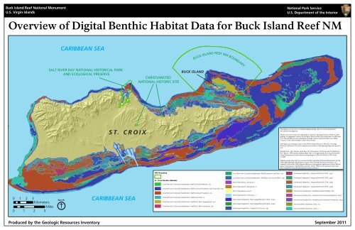
Overview of Digital Benthic Habitat Data for <strong>Buck</strong> <strong>Island</strong> <strong>Reef</strong> NM<br />
CARIBBEAN SEA<br />
BUCK ISLAND REEF NM BOUNDARY<br />
SALT RIVER BAY NATIONAL HISTORICAL PARK<br />
AND ECOLOGICAL PRESERVE<br />
CHRISTIANSTED<br />
NATIONAL HISTORIC SITE<br />
BUCK ISLAND<br />
ST. CROIX<br />
This figure is an overview of compiled digital geologic data. It is not a substitute for<br />
site-specific investigations.<br />
Minor inaccuracies may exist regarding the location of geologic features relative to other<br />
geologic or geographic features on the figure. Based on the source map scale (1:6,000) and<br />
U.S. <strong>National</strong> Map Accuracy Standards, geologic features represented here are within<br />
3 meters /10 feet (horizontally) of their true location.<br />
This figure was prepared as part of the NPS <strong>Geologic</strong> <strong>Resources</strong> Division’s <strong>Geologic</strong><br />
<strong>Resources</strong> <strong>Inventory</strong>. The source map used in creation of the digital geologic data product<br />
was:<br />
Kendall, M.S., M.E. Monaco, K.R. Buja, J.D. Christensen, C.R. Kruer, and M, Finkbeiner,<br />
R.A. Warner. 1999. Benthic Habitat Map of the U.S. Virgin <strong>Island</strong>s-St. Croix; Prepared by<br />
Visual Interpretation from Remote Sensing Imagery Collect by NOAA in 1999 (scale<br />
1:6,000).<br />
Digital geologic data and cross sections for <strong>Buck</strong> <strong>Island</strong> <strong>Reef</strong> <strong>National</strong> <strong>Monument</strong>, and all<br />
other digital geologic data prepared as part of the <strong>Geologic</strong> <strong>Resources</strong> <strong>Inventory</strong>, are<br />
available online at the NPS Integrated Resource Management Applications Portal (IRMA):<br />
https://irma.nps.gov/ App/Reference/Search. (Enter “GRI” as the search text and select<br />
<strong>Buck</strong> <strong>Island</strong> <strong>Reef</strong> <strong>National</strong> <strong>Monument</strong> from the unit list.)<br />
NPS Boundary<br />
Coral <strong>Reef</strong> and Colonized Hardbottom, <strong>Reef</strong>/Scattered Coral-Rock, rscr<br />
Submerged Vegetation, Seagrass/Patchy/10-30%, sgp1<br />
0 1 2 3<br />
Kilometers<br />
Miles<br />
0 1 2 3<br />
North<br />
CARIBBEAN SEA<br />
St. Croix Benthic Habitats<br />
Coral <strong>Reef</strong> and Colonized Hardbottom, <strong>Reef</strong>/Colonized Bedrock, rcb<br />
Coral <strong>Reef</strong> and Colonized Hardbottom, <strong>Reef</strong>/Colonized Pavement with Channels, rcpc<br />
Coral <strong>Reef</strong> and Colonized Hardbottom, <strong>Reef</strong>/Colonized Pavement, rcp<br />
Coral <strong>Reef</strong> and Colonized Hardbottom, <strong>Reef</strong>/Linear <strong>Reef</strong>, rlr<br />
Coral <strong>Reef</strong> and Colonized Hardbottom, <strong>Reef</strong>/Patch <strong>Reef</strong> (Aggregated), rpra<br />
Coral <strong>Reef</strong> and Colonized Hardbottom, <strong>Reef</strong>/Patch <strong>Reef</strong> (Individual), rpri<br />
Coral <strong>Reef</strong> and Colonized Hardbottom, <strong>Reef</strong>/Spur and Groove <strong>Reef</strong>, rsgr<br />
Other Delineations, Artificial, a<br />
Other Delineations, Mangrove, m<br />
Other Delineations, Land, l<br />
Other Delineations, Unknown, u<br />
Submerged Vegetation, Macroalgae/Patchy/10-50%, map1<br />
Submerged Vegetation, Macroalgae/Patchy/50-90%, map2<br />
Submerged Vegetation, Seagrass/Continuous, sgc<br />
Submerged Vegetation, Seagrass/Patchy/30-50%, sgp2<br />
Submerged Vegetation, Seagrass/Patchy/50-70%, sgp3<br />
Submerged Vegetation, Seagrass/Patchy/70-90%, sgp4<br />
Uncolonized Hardbottom, Hardbottom/<strong>Reef</strong> Rubble, hbrr<br />
Uncolonized Hardbottom, Hardbottom/Uncolonized Bedrock, hbub<br />
Uncolonized Hardbottom, Hardbottom/Uncolonized Pavement, hbup<br />
Unconsolidated Sediments, Mud, mu<br />
Unconsolidated Sediments, Sand, s<br />
Produced by the <strong>Geologic</strong> <strong>Resources</strong> <strong>Inventory</strong> September 2011