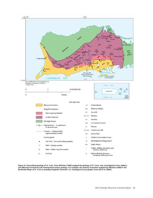
(Pliocene) years ago (Gill et al. 1989, 2002; McLaughlin et al. 1995). Pliocene and Pleistocene Epochs: Development of <strong>Reef</strong>s around St. Croix Shoaling continued into the Pliocene Epoch (5.3 million to 2.6 million years ago) and resulted in the development of a reef and lagoon system around St. Croix, represented by the Blessing Formation (fig. 22). Gill et al. (1989, 2002) introduced this rock formation as part of St. Croix’s stratigraphy. Because its naming postdates Whetten (1966), the Blessing Formation does not appear on the digital geologic map for <strong>Buck</strong> <strong>Island</strong> <strong>Reef</strong> <strong>National</strong> <strong>Monument</strong>. The extensive reef and lagoon system of the Blessing Formation that formed along the western and southern shorelines of St. Croix indicates that by the Pliocene Epoch, the present-day shoreline configuration of St. Croix was established (Gill et al. 1989). The arcuate distribution of reef and lagoon suggests that the area was an embayment at the time of establishment (Gill et al. 1989). Tectonic and global sea level changes repeatedly exposed the reefs, notably during lower sea level at 10.5 million and 5.5 million years ago (McLaughlin et al. 1995). Normal faulting of the Blessing Formation documents continued tectonic activity on St. Croix into the Pliocene Epoch and later (Gill et al. 2002). Pleistocene and Holocene Epochs: <strong>Reef</strong> Formation around <strong>Buck</strong> <strong>Island</strong> The earliest known reefs in the vicinity of <strong>Buck</strong> <strong>Island</strong> were most likely formed about 125,000 years ago (Hubbard 1991). Uranium-thorium ages from the Pleistocene strata along the western end of <strong>Buck</strong> <strong>Island</strong> and beneath the eastern reefs show reef formation at 125,000 and 102,000 years ago (Dennis Hubbard, professor, Oberlin College, written communication, January 21, 2011). After these early reefs formed, however, sea level dropped to perhaps 100 m (330 ft) below present-day levels due to Pleistocene glaciation. Ice-age conditions resulted in global cooling and the incorporation of large volumes of ocean water into continental-scale glaciers and polar ice caps. Lower sea levels exposed the entire St. Croix shelf to subaerial erosion and dissolution of carbonate by rainwater (Hubbard 1991). At 9,500 years ago, the carbonate platform around <strong>Buck</strong> <strong>Island</strong> was still flooded. The platform that underlies the Holocene reef system at the national monument is the result of both reef accretion and later physiochemical degradation during the Pleistocene (Hubbard 1991). <strong>Reef</strong> development lagged behind sea-level lowering for 1,800 years. At about 7,700 years ago, and approximately 15 m (50 ft) below present-day sea level, reef development initiated near <strong>Buck</strong> <strong>Island</strong> at <strong>Buck</strong> <strong>Island</strong> Bar. According to Hubbard et al. (2005), past topographic highs played an important role in determining the location and timing of reef development. Most reefs formed atop “benches” left after the previous sea-level low. Throughout the development of the Holocene reef, A. palmata dominated the shelf edge, while massive corals prevailed closer to the island (fig. 23). However, analysis of core data shows the decline and disappearance of A. palmata during two periods: 7,200–5,200 years ago and 3,030–2,005 years ago. During these intervals, massive corals dominated. The reason for these gaps in A. palmata is not explained by local changes in the physical environment and may have a regional or global cause (Hubbard et al. 2005). <strong>Reef</strong> accretion along <strong>Buck</strong> <strong>Island</strong> Bar continued until about 1,200 years ago, and the reefs around <strong>Buck</strong> <strong>Island</strong> largely assumed their present character by 1,000 years ago. The makeup of modern reefs mimics the composition patterns shown in the cores of past reefs with 22% coral, 19% void space, and 59% sediment (sand and gravel) (Hubbard et al. 2005). The coral fraction is dominated by A. palmata. With respect to structure, over the past 7,700 years, the south-reef crest appears to have remained slightly shallower than its northern counterpart, a condition that persists today. Observations after Hurricane Hugo in 1989 suggest that this difference in elevation is related to the piling up of debris on the broader, south-reef crest by high waves from storms passing south of St. Croix (Hubbard et al. 2005). Also, the south reef is more variable in species composition than the north reef, a condition that is exhibited by the modern reef community. 28 NPS <strong>Geologic</strong> <strong>Resources</strong> Division
Figure 22. Generalized geology of St. Croix. Since Whetten (1966) mapped the geology of St. Croix, new investigations have added a unit (Blessing Formation) and reinterpreted surface geology. For example, the Jealousy Formation mapped by Whetten (1966) in the Northside Range of St. Croix is probably Kingshill Limestone. U.S. <strong>Geologic</strong>al Survey graphic from Gill et al. (2002). BUIS <strong>Geologic</strong> <strong>Resources</strong> <strong>Inventory</strong> Report 29
- Page 1 and 2: National Park Service U.S. Departme
- Page 3 and 4: Buck Island Reef National Monument
- Page 5 and 6: Contents List of Figures ..........
- Page 7 and 8: Executive Summary This report accom
- Page 9 and 10: Introduction The following section
- Page 11 and 12: Figure 2. Location map for Buck Isl
- Page 13: Figure 5. Haystacks. Patch reefs co
- Page 16 and 17: generation of tropical storms and h
- Page 18 and 19: Island lagoon, which grow there, wo
- Page 20 and 21: The hurricane season runs from late
- Page 22 and 23: Figure 6. Major oceanographic curre
- Page 24 and 25: Figure 10. Beach sand at Turtle Bay
- Page 26 and 27: Table 1. Storm history at Buck Isla
- Page 28 and 29: limestone, record the existence of
- Page 30 and 31: communications, September 20, 2011)
- Page 32 and 33: Figure 15. Uncolonized and colonize
- Page 34 and 35: Figure 20. Scattered coral or rock
- Page 38 and 39: Figure 23. Reef development around
- Page 41 and 42: Geologic Map Data This section summ
- Page 43 and 44: Buck Island Reef National Monument
- Page 45 and 46: Map Unit Properties Table: Buck Isl
- Page 47 and 48: Gray-shaded rows indicate units not
- Page 49: Gray-shaded rows indicate units not
- Page 52 and 53: epidote. A yellow-green, pistachio-
- Page 54 and 55: tuff. Generally fine-grained, igneo
- Page 56 and 57: Gill, I. P., D. K. Hubbard, P. P. M
- Page 58 and 59: National Park Service. 1984. Buck I
- Page 61 and 62: Additional References This section
- Page 63 and 64: The Department of the Interior prot