Buck Island Reef National Monument Geologic Resources Inventory
Buck Island Reef National Monument Geologic Resources Inventory
Buck Island Reef National Monument Geologic Resources Inventory

You also want an ePaper? Increase the reach of your titles
YUMPU automatically turns print PDFs into web optimized ePapers that Google loves.
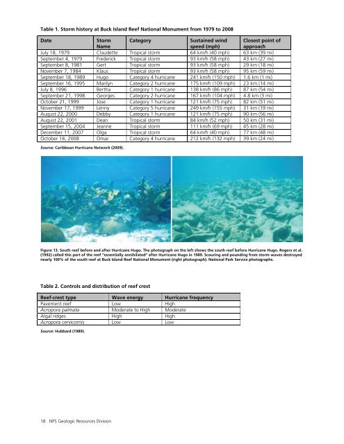
Table 1. Storm history at <strong>Buck</strong> <strong>Island</strong> <strong>Reef</strong> <strong>National</strong> <strong>Monument</strong> from 1979 to 2008<br />
Date<br />
Storm<br />
Name<br />
Category<br />
Sustained wind<br />
speed (mph)<br />
Closest point of<br />
approach<br />
July 18, 1979 Claudette Tropical storm 64 km/h (40 mph) 63 km (39 mi)<br />
September 4, 1979 Frederick Tropical storm 93 km/h (58 mph) 43 km (27 mi)<br />
September 8, 1981 Gert Tropical storm 93 km/h (58 mph) 29 km (18 mi)<br />
November 7, 1984 Klaus Tropical storm 93 km/h (58 mph) 95 km (59 mi)<br />
September 18, 1989 Hugo Category 4 hurricane 241 km/h (150 mph) 1.6 km (1 mi)<br />
September 16, 1995 Marilyn Category 2 hurricane 175 km/h (109 mph) 23 km (14 mi)<br />
July 8, 1996 Bertha Category 1 hurricane 138 km/h (86 mph) 87 km (54 mi)<br />
September 21, 1998 Georges Category 2 hurricane 167 km/h (104 mph) 4.8 km (3 mi)<br />
October 21, 1999 Jose Category 1 hurricane 121 km/h (75 mph) 82 km (51 mi)<br />
November 17, 1999 Lenny Category 5 hurricane 249 km/h (155 mph) 31 km (19 mi)<br />
August 22, 2000 Debby Category 1 hurricane 121 km/h (75 mph) 90 km (56 mi)<br />
August 22, 2001 Dean Tropical storm 84 km/h (52 mph) 50 km (31 mi)<br />
September 15, 2004 Jeanne Tropical storm 111 km/h (69 mph) 45 km (28 mi)<br />
December 11, 2007 Olga Tropical storm 64 km/h (40 mph) 77 km (48 mi)<br />
October 16, 2008 Omar Category 4 hurricane 212 km/h (132 mph) 39 km (24 mi)<br />
Source: Caribbean Hurricane Network (2009).<br />
Figure 13. South reef before and after Hurricane Hugo. The photograph on the left shows the south reef before Hurricane Hugo. Rogers et al.<br />
(1992) called this part of the reef “essentially annihilated” after Hurricane Hugo in 1989. Scouring and pounding from storm waves destroyed<br />
nearly 100% of the south reef at <strong>Buck</strong> <strong>Island</strong> <strong>Reef</strong> <strong>National</strong> <strong>Monument</strong> (right photograph). <strong>National</strong> Park Service photographs.<br />
Table 2. Controls and distribution of reef crest<br />
<strong>Reef</strong>-crest type Wave energy Hurricane frequency<br />
Pavement reef Low High<br />
Acropora palmata Moderate to High Moderate<br />
Algal ridges High High<br />
Acropora cervicornis Low Low<br />
Source: Hubbard (1989).<br />
18 NPS <strong>Geologic</strong> <strong>Resources</strong> Division