

Soil Survey of Sweet Grass County Area, Montana - Soil Data Mart
Soil Survey of Sweet Grass County Area, Montana - Soil Data Mart
Soil Survey of Sweet Grass County Area, Montana - Soil Data Mart

Create successful ePaper yourself
Turn your PDF publications into a flip-book with our unique Google optimized e-Paper software.
How to Use This <strong>Soil</strong> <strong>Survey</strong><br />
Detailed <strong>Soil</strong> Maps<br />
The detailed soil maps can be useful in planning the use and management <strong>of</strong> small areas.<br />
To find information about your area <strong>of</strong> interest, you can locate the Section, Township, and Range by zooming in<br />
on the Index to Map Sheets, or you can go to the Web <strong>Soil</strong> <strong>Survey</strong> at (http://websoilsurvey.nrcs.usda.gov/app/).<br />
Note the map unit symbols that are in that area. The Contents lists the map units by symbol and name and<br />
shows the page where each map unit is described.<br />
See the Contents for sections <strong>of</strong> this publication that may address your specific needs.
ii<br />
This soil survey is a publication <strong>of</strong> the National Cooperative <strong>Soil</strong> <strong>Survey</strong>, a joint effort<br />
<strong>of</strong> the United States Department <strong>of</strong> Agriculture and other Federal agencies, State<br />
agencies including the Agricultural Experiment Stations, and local agencies. The<br />
Natural Resources Conservation Service (formerly the <strong>Soil</strong> Conservation Service) has<br />
leadership for the Federal part <strong>of</strong> the National Cooperative <strong>Soil</strong> <strong>Survey</strong>.<br />
Major fieldwork for this soil survey was completed in 1997. <strong>Soil</strong> names and<br />
descriptions were approved in 1997. Unless otherwise indicated, statements in this<br />
publication refer to conditions in the survey area in 1997. This survey was made<br />
cooperatively by the Natural Resources Conservation Service and the <strong>Montana</strong><br />
Agricultural Experiment Station. It is part <strong>of</strong> the technical assistance furnished to the<br />
<strong>Sweet</strong> <strong>Grass</strong> <strong>County</strong> Conservation District.<br />
The most current <strong>of</strong>ficial data are available through the NRCS <strong>Soil</strong> <strong>Data</strong> <strong>Mart</strong> website<br />
at http://soildatamart.nrcs.usda.gov. <strong>Soil</strong> maps in this survey may be copied without<br />
permission. Enlargement <strong>of</strong> these maps, however, could cause misunderstanding <strong>of</strong> the<br />
detail <strong>of</strong> mapping. If enlarged, maps do not show the small areas <strong>of</strong> contrasting soils<br />
that could have been shown at a larger scale.<br />
The United States Department <strong>of</strong> Agriculture (USDA) prohibits discrimination in all <strong>of</strong><br />
its programs on the basis <strong>of</strong> race, color, national origin, gender, religion, age, disability,<br />
political beliefs, sexual orientation, and marital or family status. (Not all prohibited bases<br />
apply to all programs.) Persons with disabilities who require alternative means for<br />
communication <strong>of</strong> program information (Braille, large print, audiotape, etc.) should<br />
contact the USDA’s TARGET Center at 202-720-2600 (voice or TDD).<br />
To file a complaint <strong>of</strong> discrimination, write USDA, Director, Office <strong>of</strong> Civil Rights,<br />
Room 326W, Whitten Building, 14th and Independence Avenue SW, Washington, DC<br />
20250-9410, or call 202-720-5964 (voice or TDD). USDA is an equal opportunity<br />
provider and employer.<br />
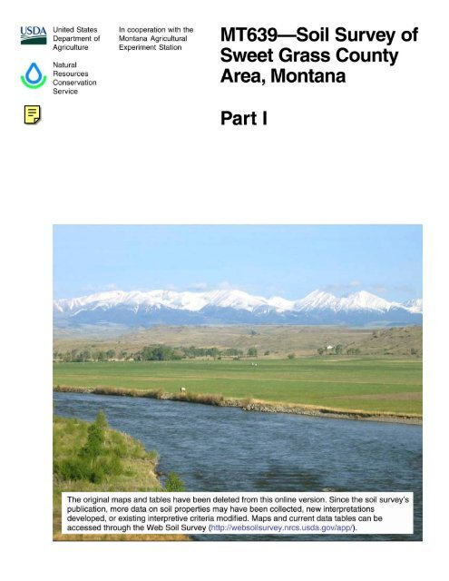
Cover: Two dominant features <strong>of</strong> the <strong>Sweet</strong> <strong>Grass</strong> <strong>County</strong> landscape are the Yellowstone River and<br />
Crazy Mountains. The river valley soils in this view are mainly Fairway and Korchea loams. <strong>Soil</strong>s that<br />
are commonly found in the rangeland are Cabbart loam, Yawdim clay loam, and Reedpoint very<br />
channery loams. The high terraces in the background are mostly Roy and Tamaneen cobbly loams.<br />
Representative soils in the upper foothills are Adel loam on the rangeland and Stemple very cobbly<br />
loam in the forested areas.<br />
Additional information about the Nation’s natural resources is available online<br />
from the Natural Resources Conservation Service at http://www.nrcs.usda.gov.
iii<br />
Contents<br />
Part I<br />
How To Use This <strong>Soil</strong> <strong>Survey</strong> .................................. i<br />
Alphabetical Index to Map Units ........................ xiv<br />
Summary <strong>of</strong> Tables ..............................................xxii<br />
Foreword ............................................................. xxv<br />
General Nature <strong>of</strong> the <strong>Survey</strong> <strong>Area</strong> .......................... 1<br />
History and Development .................................... 1<br />
Industry, Transportation, and Recreation ............. 2<br />
Natural Resources ............................................... 3<br />
Physiography, Drainage, and Geology ................ 3<br />
Mining .................................................................. 9<br />
Oil, Gas, and Coal ............................................. 10<br />
Geothermal Resources ...................................... 10<br />
Ground-Water Resources .................................. 10<br />
Seismicity........................................................... 11<br />
Climate............................................................... 11<br />
How This <strong>Survey</strong> Was Made .................................. 12<br />
Formation and Classification <strong>of</strong> the <strong>Soil</strong>s .......... 17<br />
Formation <strong>of</strong> the <strong>Soil</strong>s ............................................ 17<br />
Climate............................................................... 17<br />
Living Organisms ............................................... 17<br />
Topography ........................................................ 18<br />
Parent Material .................................................. 18<br />
Time ................................................................... 19<br />
Classification <strong>of</strong> the <strong>Soil</strong>s ....................................... 19<br />
<strong>Soil</strong> Series and Their Morphology....................... 20<br />
Absarokee Series .............................................. 20<br />
Absher Family .................................................... 21<br />
Absher Series .................................................... 23<br />
Adel Series ........................................................ 24<br />
Albicalis Taxadjunct ........................................... 25<br />
Amherst Series .................................................. 26<br />
Amor Series ....................................................... 27<br />
Arrowpeak Series .............................................. 28<br />
Ashbon Series ................................................... 29<br />
Attewan Series ................................................... 30<br />
Bacbuster Series ............................................... 31<br />
Bearmouth Taxadjunct ....................................... 32<br />
Beaverell Series ................................................. 33<br />
Beaverton Series ............................................... 34<br />
Beehive Series ................................................... 35<br />
Beenom Taxadjunct ........................................... 36<br />
Bigsag Family .................................................... 37<br />
Birney Series ..................................................... 38<br />
Blacksheep Series ............................................. 39<br />
Blossberg Taxadjunct ......................................... 39<br />
Bonebasin Series .............................................. 41<br />
Bowery Series.................................................... 42<br />
Boxwell Series ................................................... 43<br />
Breeton Series ................................................... 44<br />
Bridger Series .................................................... 44<br />
Cabba Series ..................................................... 46<br />
Cabbart Series ................................................... 46<br />
Cambeth Series ................................................. 47<br />
Castner Series ................................................... 48<br />
Cheadle Series .................................................. 49<br />
Chinook Series .................................................. 50<br />
Clunton Series ................................................... 51<br />
Cowood Series .................................................. 52<br />
Creed Series ...................................................... 53<br />
Danaher Series .................................................. 54<br />
Danvers Series .................................................. 56<br />
Delpoint Series .................................................. 57<br />
Dimmick Series .................................................. 58<br />
Doby Series ....................................................... 59<br />
Doney Series ..................................................... 59<br />
Duckcreek Series............................................... 60<br />
Elve Series ......................................................... 61<br />
Ethridge Series .................................................. 62<br />
Evanston Series ................................................. 63<br />
Fairfield Series ................................................... 64<br />
Fairway Series ................................................... 66<br />
Farnuf Series ..................................................... 67<br />
Fifer Series ........................................................ 68<br />
Foolhen Series ................................................... 69<br />
Frenchcreek Series ............................................ 70<br />
Gerdrum Series ................................................. 71<br />
Gilispie Series .................................................... 72<br />
Greybear Series................................................. 73
iv<br />
Havre Series ...................................................... 74<br />
Hinterland Series ............................................... 75<br />
Klayent Series .................................................... 76<br />
Knep Family ....................................................... 78<br />
Knep Series ....................................................... 78<br />
Kobase Series ................................................... 79<br />
Korchea Series .................................................. 80<br />
Kremlin Series ................................................... 81<br />
Laceycreek Series ............................................. 82<br />
Lallie Family ....................................................... 83<br />
Lap Series.......................................................... 84<br />
Larry Series ....................................................... 85<br />
Ledger Family .................................................... 87<br />
Libeg Series ....................................................... 88<br />
Linwell Series .................................................... 89<br />
Lonna Series ..................................................... 90<br />
Lymanson Series ............................................... 91<br />
Macar Series...................................................... 92<br />
Marcott Taxadjunct ............................................. 93<br />
Marmarth Series ................................................ 94<br />
<strong>Mart</strong>insdale Series ............................................. 95<br />
McIlwaine Series................................................ 96<br />
Meadowcreek Series ......................................... 97<br />
Meagher Series ................................................. 98<br />
Megonot Series ............................................... 100<br />
Melville Series ................................................. 101<br />
Merino Series .................................................. 102<br />
Millerlake Series .............................................. 103<br />
Monaberg Taxadjunct ...................................... 103<br />
Mowbray Series ............................................... 105<br />
Mowbray Taxadjunct ........................................ 106<br />
Nesda Series ................................................... 107<br />
Newtman Taxadjunct ........................................ 108<br />
Novary Series .................................................. 109<br />
Overfelt Series ................................................. 110<br />
Perma Series ................................................... 111<br />
Pianohill Series ................................................ 112<br />
Pintlar Series ................................................... 113<br />
Radersburg Series ........................................... 114<br />
Redchief Series ............................................... 115<br />
Redfern Series ................................................. 116<br />
Reedpoint Series ............................................. 117<br />
Reedwest Series.............................................. 118<br />
Rentsac Series ................................................ 118<br />
Richey Series................................................... 119<br />
Rocko Series ................................................... 120<br />
Roy Series ....................................................... 121<br />
Roy Taxadjunct ................................................ 122<br />
Sagedale Series .............................................. 124<br />
Sawicki Series ................................................. 125<br />
Shambo Series ................................................ 126<br />
Shawmut Series ............................................... 127<br />
Sieben Series .................................................. 128<br />
Sinnigam Series .............................................. 129<br />
Sixbeacon Series ............................................. 130<br />
Soapcreek Series ............................................ 131<br />
Stemple Series ................................................ 133<br />
Swampcreek Series ......................................... 134<br />
<strong>Sweet</strong>grass Series ........................................... 135<br />
<strong>Sweet</strong>weed Series ........................................... 137<br />
Tamaneen Series ............................................. 138<br />
Tanna Series .................................................... 139<br />
Thibadeau Series ............................................ 140<br />
Tiban Series..................................................... 141<br />
Tibson Series ................................................... 142<br />
Ticell Series ..................................................... 142<br />
Timberlin Series ............................................... 143<br />
Tongue River Series ........................................ 144<br />
Turner Series ................................................... 145<br />
Twilight Series .................................................. 147<br />
Vebar Series .................................................... 147<br />
Vershal Series.................................................. 148<br />
Verson Series .................................................. 149<br />
Vision Series .................................................... 150<br />
Warwood Series .............................................. 151<br />
Wayden Series ................................................. 153<br />
Weedzunit Series ............................................. 153<br />
Whitlash Series ................................................ 154<br />
Whitore Series ................................................. 155<br />
Winifred Series ................................................ 156
v<br />
Winkler Series.................................................. 157<br />
Winspect Series ............................................... 158<br />
Work Series ..................................................... 159<br />
Worock Series.................................................. 160<br />
Yamacall Series ............................................... 162<br />
Yawdim Series ................................................. 163<br />
Detailed <strong>Soil</strong> Map Units ..................................... 173<br />
100B—Nesda-Meadowcreek-Clunton loams,<br />
0 to 4 percent slopes ................................. 174<br />
102B—Ledger family, clay loam, 1 to 4<br />
percent slopes ........................................... 174<br />
103A—Havre loam, 0 to 2 percent slopes ....... 175<br />
104A—Meadowcreek loam, 0 to 2 percent<br />
slopes ........................................................ 175<br />
106B—Thibadeau loam, channeled, saline,<br />
0 to 4 percent slopes ................................. 175<br />
107A—Nesda-McIlwaine loams, 0 to 2<br />
percent slopes ........................................... 176<br />
109A—Meadowcreek-Nesda loams,<br />
0 to 2 percent slopes ................................. 176<br />
110D—Cabbart loam, 2 to 15 percent<br />
slopes ........................................................ 177<br />
110E—Cabbart loam, 15 to 35 percent<br />
slopes ........................................................ 177<br />
112C—Cabbart-Delpoint, calcareous, loams,<br />
2 to 8 percent slopes ................................. 177<br />
112D—Cabbart-Delpoint, calcareous, loams,<br />
8 to 15 percent slopes ............................... 178<br />
112E—Cabbart-Delpoint, calcareous loams,<br />
15 to 35 percent slopes ............................. 178<br />
115D—Yawdim-Rentsac-Cabbart complex,<br />
2 to 15 percent slopes ............................... 179<br />
116F—Cabbart-Rock outcrop complex,<br />
15 to 60 percent slopes ............................. 179<br />
117C—Cabbart-Tanna complex, 2 to 8<br />
percent slopes ........................................... 180<br />
118C—Hinterland clay loam, 0 to 8 percent<br />
slopes ........................................................ 180<br />
127C—Marmarth loam, 2 to 8 percent<br />
slopes ........................................................ 181<br />
129C—Tanna-Cabbart complex, 2 to 8<br />
percent slopes ........................................... 181<br />
129D—Tanna-Cabbart complex, 8 to 15<br />
percent slopes ........................................... 182<br />
130C—Tanna-Hinterland clay loams, 2 to 8<br />
percent slopes ........................................... 182<br />
130D—Tanna-Hinterland clay loams, 8 to 15<br />
percent slopes ........................................... 183<br />
131D—Reedpoint very channery loam,<br />
2 to 15 percent slopes ............................... 183<br />
131F—Reedpoint very channery loam,<br />
15 to 60 percent slopes ............................. 183<br />
134B—Yamacall loam, 1 to 4 percent<br />
slopes ........................................................ 184<br />
134C—Yamacall loam, 4 to 8 percent<br />
slopes ........................................................ 184<br />
134D—Yamacall loam, 8 to 15 percent<br />
slopes ........................................................ 184<br />
135A—Fairway loam, 0 to 2 percent<br />
slopes ........................................................ 185<br />
138D—Cabbart-Megonot-Kobase clay loams,<br />
2 to 15 percent slopes ............................... 185<br />
139C—Cabbart-Delpoint loams, 2 to 8<br />
percent slopes ........................................... 186<br />
139D—Cabbart-Delpoint loams, 8 to 15<br />
percent slopes ........................................... 186<br />
139E—Cabbart-Delpoint loams, 15 to 35<br />
percent slopes ........................................... 187<br />
140F—Yawdim-Rentsac complex, 15 to 60<br />
percent slopes ........................................... 187<br />
141C—Marmarth-Cabbart loams, 2 to 8<br />
percent slopes ........................................... 188<br />
141D—Marmarth-Cabbart loams, 8 to 15<br />
percent slopes ........................................... 188<br />
142C—Tanna clay loam, 2 to 8 percent<br />
slopes ........................................................ 189<br />
144B—Evanston loam, 0 to 4 percent<br />
slopes ........................................................ 189<br />
144C—Evanston loam, 4 to 8 percent<br />
slopes ........................................................ 189
vi<br />
144D—Evanston loam, 8 to 15 percent<br />
slopes ........................................................ 190<br />
145C—Boxwell, calcareous-Cabbart loams,<br />
2 to 8 percent slopes ................................. 190<br />
146B—Ethridge clay loam, 1 to 4 percent<br />
slopes ........................................................ 190<br />
146C—Ethridge clay loam, 4 to 8 percent<br />
slopes ........................................................ 191<br />
147B—Kremlin loam, 0 to 4 percent slopes .... 191<br />
147C—Kremlin loam, 4 to 8 percent slopes .... 191<br />
147D—Kremlin loam, 8 to 15 percent<br />
slopes ........................................................ 192<br />
148E—Cabbart-Cambeth complex, 4 to 35<br />
percent slopes ........................................... 192<br />
150C—Kobase clay loam, 2 to 8 percent<br />
slopes ........................................................ 193<br />
150D—Kobase clay loam, 8 to 15 percent<br />
slopes ........................................................ 193<br />
151C—Cabbart-Boxwell loams, 2 to 8<br />
percent slopes ........................................... 193<br />
151D—Cabbart-Boxwell loams, 8 to 15<br />
percent slopes ........................................... 194<br />
153C—Ethridge-Reedpoint complex, 2 to 8<br />
percent slopes ........................................... 194<br />
153D—Ethridge-Reedpoint complex, 8 to 15<br />
percent slopes ........................................... 195<br />
154E—Evanston-Reedpoint complex, 8 to 35<br />
percent slopes ........................................... 195<br />
155E—Cabbart-Delpoint loams, moist,<br />
15 to 35 percent slopes ............................. 196<br />
156C—Twilight-Blacksheep fine sandy loams,<br />
2 to 8 percent slopes ................................. 196<br />
157F—Cabbart, moist-Delpoint-Rock outcrop<br />
complex, 15 to 60 percent slopes.............. 197<br />
159A—Marcott cobbly clay loam, 0 to 2<br />
percent slopes ........................................... 197<br />
161B—<strong>Mart</strong>insdale gravelly loam, 0 to 4<br />
percent slopes ........................................... 198<br />
161C—<strong>Mart</strong>insdale gravelly loam, 4 to 8<br />
percent slopes ........................................... 198<br />
163C—Absher clay, 0 to 8 percent slopes ....... 198<br />
166B—Richey silty clay, 0 to 4 percent<br />
slopes ........................................................ 199<br />
166C—Richey silty clay, 4 to 8 percent<br />
slopes ........................................................ 199<br />
167F—Yawdim-Birney-Rock outcrop complex,<br />
15 to 60 percent slopes ............................. 199<br />
168D—Chinook fine sandy loam, 8 to 15<br />
percent slopes ........................................... 200<br />
169C—Ethridge-Tanna clay loams, 2 to 8<br />
percent slopes ........................................... 200<br />
170C—Gerdrum-Creed complex, 0 to 8<br />
percent slopes ........................................... 201<br />
172C—Tanna-Boxwell, calcareous, complex,<br />
2 to 8 percent slopes ................................. 201<br />
172D—Tanna-Boxwell, calcareous, complex,<br />
8 to 15 percent slopes ............................... 202<br />
174C—<strong>Sweet</strong>grass clay loam, 2 to 8 percent<br />
slopes ........................................................ 202<br />
176C—Reedwest-Cabba loams, 2 to 8<br />
percent slopes ........................................... 202<br />
178F—Castner-Roy complex, 15 to 60<br />
percent slopes ........................................... 203<br />
179F—Cabba-Rock outcrop complex,<br />
15 to 60 percent slopes ............................. 203<br />
181C—Cabba-Winifred clay loams, 2 to 8<br />
percent slopes ........................................... 204<br />
181D—Cabba-Winifred clay loams, 8 to 15<br />
percent slopes ........................................... 204<br />
182C—Roy gravelly clay loam, 2 to 8 percent<br />
slopes ........................................................ 205<br />
182D—Roy gravelly clay loam, 8 to 15<br />
percent slopes ........................................... 205<br />
183A—Tamaneen gravelly loam, 0 to 2<br />
percent slopes ........................................... 206<br />
183B—Tamaneen clay loam, 0 to 4 percent<br />
slopes ........................................................ 206<br />
183C—Tamaneen gravelly clay loam, 2 to 8<br />
percent slopes ........................................... 206
vii<br />
184D—Absarokee-Shambo loams, 8 to 15<br />
percent slopes ........................................... 206<br />
185C—Amor-Castner complex, 2 to 8<br />
percent slopes ........................................... 207<br />
185D—Amor-Castner complex, 8 to 15<br />
percent slopes ........................................... 207<br />
186D—Castner channery loam, 2 to 15<br />
percent slopes ........................................... 208<br />
186E—Castner channery loam, 15 to 35<br />
percent slopes ........................................... 208<br />
188C—Linwell clay loam, 2 to 8 percent<br />
slopes ........................................................ 209<br />
189C—Shambo gravelly clay loam, 2 to 8<br />
percent slopes ........................................... 209<br />
190C—Danvers gravelly clay loam, 2 to 8<br />
percent slopes ........................................... 209<br />
191C—Castner-Farnuf complex, 2 to 8<br />
percent slopes ........................................... 209<br />
192D—Castner-Shambo complex, 8 to 15<br />
percent slopes ........................................... 210<br />
193C—Farnuf-Winifred complex, 2 to 8<br />
percent slopes ........................................... 210<br />
194C—Linwell-Amor complex, 2 to 8 percent<br />
slopes ........................................................ 211<br />
196B—Yamacall-Bigsag family complex,<br />
0 to 4 percent slopes ................................. 211<br />
197C—Work-Castner complex, 2 to 8<br />
percent slopes ........................................... 212<br />
197D—Work-Castner complex, 8 to 15<br />
percent slopes ........................................... 212<br />
201F—Yawdim-Rock outcrop complex,<br />
15 to 60 percent slopes ............................. 213<br />
202C—Castner-Absarokee complex, 2 to 8<br />
percent slopes ........................................... 213<br />
202D—Castner-Absarokee complex, 8 to 15<br />
percent slopes ........................................... 214<br />
202E—Castner-Absarokee complex, 15 to 35<br />
percent slopes ........................................... 214<br />
204A—Dimmick silty clay, 0 to 2 percent<br />
slopes ........................................................ 215<br />
206D—Hinterland-Rentsac-Cabbart complex,<br />
2 to 15 percent slopes ............................... 215<br />
208F—Cabba-Castner complex, 15 to 60<br />
percent slopes ........................................... 216<br />
209C—Fairfield gravelly loam, 2 to 8 percent<br />
slopes ........................................................ 216<br />
209D—Fairfield gravelly loam, 8 to 15<br />
percent slopes ........................................... 216<br />
210D—Cabba loam, 2 to 15 percent slopes .... 217<br />
210E—Cabba loam, 15 to 35 percent<br />
slopes ........................................................ 217<br />
213A—Korchea-Fairway-Albicalis loams,<br />
channeled, 0 to 4 percent slopes .............. 217<br />
215B—Macar loam, calcareous surface,<br />
0 to 4 percent slopes ................................. 218<br />
215C—Macar loam, calcareous surface,<br />
4 to 8 percent slopes ................................. 218<br />
215D—Macar loam, 8 to 15 percent slopes .... 219<br />
216A—Clunton clay loam, 0 to 2 percent<br />
slopes ........................................................ 219<br />
217A—Korchea loam, 0 to 2 percent<br />
slopes ........................................................ 219<br />
218C—Breeton sandy loam, 2 to 8 percent<br />
slopes ........................................................ 220<br />
218D—Breeton sandy loam, 8 to 15 percent<br />
slopes ........................................................ 220<br />
219A—Klayent clay loam, 0 to 2 percent<br />
slopes ........................................................ 220<br />
220C—Amor-Work complex, 2 to 8 percent<br />
slopes ........................................................ 221<br />
220D—Amor-Work complex, 8 to 15 percent<br />
slopes ........................................................ 221<br />
221C—Amor-Farnuf loams, 2 to 8 percent<br />
slopes ........................................................ 222<br />
224B—Shambo loam, 0 to 4 percent slopes ... 222<br />
224C—Shambo loam, 4 to 8 percent slopes ... 222<br />
224D—Shambo loam, 8 to 15 percent<br />
slopes ........................................................ 223<br />
225C—Amor-Cabba loams, 2 to 8 percent<br />
slopes ........................................................ 223
viii<br />
225D—Amor-Cabba loams, 8 to 15 percent<br />
slopes ........................................................ 224<br />
227F—Cabba, moist-Rock outcrop complex,<br />
15 to 60 percent slopes ............................. 224<br />
229C—Absarokee-Cabba loams, 2 to 8<br />
percent slopes ........................................... 224<br />
229D—Absarokee-Cabba loams, 8 to 15<br />
percent slopes ........................................... 225<br />
230B—Farnuf loam, 0 to 4 percent slopes ...... 225<br />
230C—Farnuf loam, 4 to 8 percent slopes ...... 226<br />
230D—Farnuf loam, 8 to 15 percent<br />
slopes ........................................................ 226<br />
231C—Doney-Cabba loams, 2 to 8 percent<br />
slopes ........................................................ 226<br />
231D—Doney-Cabba loams, 8 to 15 percent<br />
slopes ........................................................ 227<br />
232B—Work loam, 0 to 4 percent slopes ........ 227<br />
232C—Work loam, 4 to 8 percent slopes ........ 228<br />
236B—Verson loam, 0 to 4 percent slopes ..... 228<br />
236C—Verson loam, 4 to 8 percent slopes ..... 228<br />
237B—Thibadeau loam, saline, 0 to 4<br />
percent slopes ........................................... 229<br />
238C—Sagedale-Cabba complex, 2 to 8<br />
percent slopes ........................................... 229<br />
238F—Sagedale-Cabba complex, 8 to 35<br />
percent slopes ........................................... 229<br />
239C—Sixbeacon gravelly loam, 2 to 8<br />
percent slopes ........................................... 230<br />
241D—Yawdim clay loam, 2 to 15 percent<br />
slopes ........................................................ 230<br />
245C—Lonna silt loam, 2 to 8 percent<br />
slopes ........................................................ 231<br />
249B—Soapcreek clay loam, 0 to 2 percent<br />
slopes ........................................................ 231<br />
250A—Lallie family, silty clay, 0 to 2 percent<br />
slopes ........................................................ 231<br />
251B—Radersburg gravelly loam, 0 to 4<br />
percent slopes ........................................... 232<br />
252B—Roy-Swampcreek complex, 0 to 4<br />
percent slopes ........................................... 232<br />
253C—Reedwest-Castner complex, 2 to 8<br />
percent slopes ........................................... 232<br />
253D—Reedwest-Castner complex, 8 to 15<br />
percent slopes ........................................... 233<br />
253E—Reedwest-Castner complex, 15 to 35<br />
percent slopes ........................................... 233<br />
254C—Winifred clay loam, 2 to 8 percent<br />
slopes ........................................................ 234<br />
255B—Thibadeau, saline-Absher family<br />
complex, 0 to 8 percent slopes.................. 234<br />
256F—Sixbeacon-Reedpoint complex,<br />
15 to 60 percent slopes ............................. 235<br />
257B—Absher-Bigsag families, clays, 0 to 4<br />
percent slopes ........................................... 235<br />
259D—Wayden clay, 2 to 15 percent slopes ... 236<br />
260C—Wayden-Doney complex, 2 to 8<br />
percent slopes ........................................... 236<br />
261C—Absarokee-Wayden complex, 2 to 8<br />
percent slopes ........................................... 236<br />
262D—Wayden-Castner-Cabba complex,<br />
2 to 15 percent slopes ............................... 237<br />
265C—Sagedale clay loam, 2 to 8 percent<br />
slopes ........................................................ 237<br />
265D—Sagedale clay loam, 8 to 15 percent<br />
slopes ........................................................ 238<br />
266B—<strong>Sweet</strong>grass clay, 0 to 4 percent<br />
slopes ........................................................ 238<br />
267B—Beaverton gravelly sandy clay loam,<br />
0 to 4 percent slopes ................................. 238<br />
268B—Overfelt-Roy complex, 0 to 4 percent<br />
slopes ........................................................ 239<br />
269C—Danvers loam, 2 to 8 percent slopes ... 239<br />
270C—Bacbuster-Castner complex, 2 to 8<br />
percent slopes ........................................... 239<br />
270D—Bacbuster-Castner complex, 8 to 15<br />
percent slopes ........................................... 240<br />
271B—<strong>Sweet</strong>grass gravelly loam, 0 to 4<br />
percent slopes ........................................... 240<br />
274B—Work clay loam, 0 to 4 percent<br />
slopes ........................................................ 241
ix<br />
274C—Work clay loam, 4 to 8 percent<br />
slopes ........................................................ 241<br />
274D—Work clay loam, 8 to 15 percent<br />
slopes ........................................................ 241<br />
274E—Work clay loam, 15 to 35 percent<br />
slopes ........................................................ 242<br />
275B—Overfelt clay loam, 0 to 4 percent<br />
slopes ........................................................ 242<br />
276A—Larry clay loam, 0 to 2 percent<br />
slopes ........................................................ 242<br />
277B—Marcott-Larry complex, 0 to 4 percent<br />
slopes ........................................................ 243<br />
278B—Perma gravelly loam, 0 to 4 percent<br />
slopes ........................................................ 243<br />
278C—Perma gravelly loam, 4 to 8 percent<br />
slopes ........................................................ 243<br />
279C—Shambo clay loam, calcareous, 4 to 8<br />
percent slopes ........................................... 244<br />
281F—Shawmut-Castner complex, 15 to 60<br />
percent slopes ........................................... 244<br />
282B—Bowery clay loam, 0 to 4 percent<br />
slopes ........................................................ 245<br />
283F—Castner-Wayden complex, moist,<br />
15 to 60 percent slopes ............................. 245<br />
284C—Shawmut gravelly loam, 2 to 8<br />
percent slopes ........................................... 245<br />
284D—Shawmut gravelly loam, 8 to 15<br />
percent slopes ........................................... 246<br />
286F—Wayden-Rock outcrop complex,<br />
15 to 60 percent slopes ............................. 246<br />
288B—Turner sandy clay loam, 0 to 4<br />
percent slopes ........................................... 246<br />
289A—Swampcreek gravelly sandy clay loam,<br />
0 to 2 percent slopes ................................. 247<br />
290C—Breeton loam, 2 to 8 percent<br />
slopes ........................................................ 247<br />
291B—Beaverton very cobbly loam, 0 to 4<br />
percent slopes ........................................... 247<br />
294B—Roy gravelly loam, 0 to 4 percent<br />
slopes ........................................................ 248<br />
295B—Roy-Turner complex, 0 to 4 percent<br />
slopes ........................................................ 248<br />
296B—Blossberg cobbly loam, 0 to 4 percent<br />
slopes ........................................................ 249<br />
303D—Winspect cobbly loam, 4 to 15 percent<br />
slopes ........................................................ 249<br />
303E—Winspect very cobbly loam, 15 to 35<br />
percent slopes ........................................... 249<br />
304C—Shawmut-Shambo complex, 2 to 8<br />
percent slopes ........................................... 250<br />
304D—Shawmut-Shambo complex, 8 to 15<br />
percent slopes ........................................... 250<br />
307E—Cabba-Doney loams, 8 to 35 percent<br />
slopes ........................................................ 251<br />
308C—Meagher gravelly loam, 2 to 8 percent<br />
slopes ........................................................ 251<br />
309E—Ticell-Amor loams, 8 to 35 percent<br />
slopes ........................................................ 251<br />
310E—Winspect-Ticell complex, 15 to 35<br />
percent slopes ........................................... 252<br />
311C—Roy, extremely stony-Turner complex,<br />
2 to 8 percent slopes ................................. 252<br />
312D—Vershal very channery loam, 2 to 15<br />
percent slopes ........................................... 253<br />
312F—Vershal very channery loam, 15 to 60<br />
percent slopes ........................................... 253<br />
313C—Roy-Tamaneen complex, 2 to 8<br />
percent slopes ........................................... 254<br />
330C—Absarokee-Amherst complex, 2 to 8<br />
percent slopes ........................................... 254<br />
330D—Absarokee-Amherst complex, 8 to 15<br />
percent slopes ........................................... 254<br />
331F—Wayden-Castner complex, 15 to 60<br />
percent slopes ........................................... 255<br />
332D—Ticell loam, 2 to 15 percent slopes ...... 255<br />
332E—Ticell loam, 15 to 35 percent slopes .... 256<br />
333F—Shawmut-Castner-Rock outcrop<br />
complex, 15 to 60 percent slopes.............. 256<br />
335D—Cabba-Castner-Amherst complex,<br />
2 to 15 percent slopes ............................... 257
x<br />
336E—Sinnigam-Wayden complex, moist,<br />
15 to 45 percent slopes ............................. 257<br />
337C—Work gravelly clay loam, 2 to 8<br />
percent slopes ........................................... 258<br />
337D—Work gravelly clay loam, 8 to 15<br />
percent slopes ........................................... 258<br />
342E—Ashbon-Winkler-Weedzunit complex,<br />
15 to 35 percent slopes ............................. 258<br />
343F—Ashbon-Winkler-Rock outcrop<br />
complex, 35 to 60 percent slopes.............. 259<br />
344F—Vision-<strong>Sweet</strong>weed-Whitlash complex,<br />
25 to 60 percent slopes ............................. 260<br />
345D—Weedzunit-Ashbon complex, 4 to 15<br />
percent slopes ........................................... 260<br />
345E—Weedzunit-Ashbon complex, 15 to 45<br />
percent slopes ........................................... 261<br />
346E—Farnuf-Reedwest-Shawmut complex,<br />
15 to 35 percent slopes ............................. 261<br />
347D—Cheadle-Lymanson-Gilispie complex,<br />
2 to 15 percent slopes ............................... 262<br />
347E—Cheadle-Lymanson-Gilispie complex,<br />
15 to 35 percent slopes ............................. 262<br />
348E—Lymanson-Cheadle-Adel complex,<br />
8 to 35 percent slopes ............................... 263<br />
349D—Cheadle channery loam, 2 to 15<br />
percent slopes ........................................... 264<br />
350F—Castner-Mowbray-Rock outcrop<br />
complex, 25 to 60 percent slopes.............. 264<br />
351D—Whitlash-Pianohill complex, 4 to 15<br />
percent slopes ........................................... 265<br />
351E—Whitlash-Pianohill complex, 15 to 35<br />
percent slopes ........................................... 265<br />
352E—Perma-Rock outcrop complex,<br />
15 to 45 percent slopes ............................. 266<br />
353F—Ashbon-Rock outcrop-Winkler<br />
complex, 35 to 60 percent slopes.............. 266<br />
354F—Vision-Whitlash-Rock outcrop<br />
complex, 35 to 60 percent slopes.............. 267<br />
355F—Doney-Cabba, moist loams, 35 to 60<br />
percent slopes ........................................... 267<br />
356D—Redchief gravelly loam, 4 to 15<br />
percent slopes ........................................... 268<br />
357D—Cabba-Vershal complex, 4 to 15<br />
percent slopes ........................................... 268<br />
357E—Cabba-Vershal complex, 15 to 45<br />
percent slopes ........................................... 269<br />
358E—Tongue River-Danaher loams,<br />
15 to 35 percent slopes ............................. 269<br />
359F—Fifer-Cheadle-Monaberg complex,<br />
25 to 60 percent slopes ............................. 270<br />
360D—Knep family-Warwood loams, 4 to 15<br />
percent slopes ........................................... 270<br />
361E—Cowood very channery loam, 4 to 25<br />
percent slopes ........................................... 271<br />
362F—Wayden-Castner-Rock outcrop<br />
complex, 25 to 60 percent slopes.............. 271<br />
363E—Kobase-Rentsac-Megonot complex,<br />
4 to 25 percent slopes ............................... 272<br />
364E—Absarokee-Bowery loams, 15 to 45<br />
percent slopes ........................................... 272<br />
365C—Megonot-Cabbart complex, 2 to 8<br />
percent slopes ........................................... 273<br />
366C—Tanna, calcareous,-Rentsac complex,<br />
2 to 8 percent slopes ................................. 273<br />
366D—Tanna, calcareous,-Rentsac complex,<br />
8 to 15 percent slopes ............................... 274<br />
367D—Rentsac-Reedpoint complex, 2 to 15<br />
percent slopes ........................................... 274<br />
367E—Rentsac-Reedpoint complex, 15 to 35<br />
percent slopes ........................................... 275<br />
368E—Rentsac-Tanna-Rock outcrop complex,<br />
8 to 35 percent slopes ............................... 275<br />
369D—Rentsac-Tanna complex, 2 to 15<br />
percent slopes ........................................... 276<br />
369E—Rentsac-Tanna complex, 15 to 35<br />
percent slopes ........................................... 276<br />
370D—Greybear-Rentsac complex, 2 to 15<br />
percent slopes ........................................... 277<br />
371D—Whitlash cobbly sandy loam, 2 to 15<br />
percent slopes ........................................... 277
xi<br />
371E—Whitlash cobbly sandy loam, 15 to 35<br />
percent slopes ........................................... 278<br />
372D—Castner-Amherst complex, 2 to 15<br />
percent slopes ........................................... 278<br />
372E—Castner-Amherst complex, 15 to 35<br />
percent slopes ........................................... 278<br />
373D—Ticell-Castner complex, 2 to 15<br />
percent slopes ........................................... 279<br />
374F—Cabbart, moist-Delpoint-Rock outcrop<br />
complex, 15 to 45 percent slopes.............. 279<br />
375D—Cabbart-Rentsac, moist, complex,<br />
2 to 15 percent slopes ............................... 280<br />
376E—Chinook-Twilight fine sandy loams,<br />
8 to 25 percent slopes ............................... 280<br />
377F—Tongue River-Cabba, moist-Adel<br />
loams, 15 to 60 percent slopes ................. 281<br />
378D—Melville cobbly loam, 2 to 15 percent<br />
slopes, stony ............................................. 282<br />
379F—Tongue River-Arrowpeak, moist<br />
complex, 15 to 60 percent slopes.............. 282<br />
381E—Duckcreek-Arrowpeak complex,<br />
8 to 45 percent slopes ............................... 282<br />
382E—Fifer-Knep complex, 15 to 45 percent<br />
slopes ........................................................ 283<br />
383D—Fifer-Rock outcrop complex, 4 to 15<br />
percent slopes ........................................... 283<br />
384E—Fifer-Cheadle complex, 15 to 45<br />
percent slopes ........................................... 284<br />
385E—Millerlake-Arrowpeak-Adel complex,<br />
8 to 35 percent slopes ............................... 284<br />
386D—Millerlake loam, 4 to 15 percent<br />
slopes ........................................................ 285<br />
387E—Tongue River-Novary-Cowood<br />
complex, 4 to 45 percent slopes................ 285<br />
388D—Adel loam, 2 to 15 percent slopes ....... 286<br />
391F—Tongue River-Timberlin complex,<br />
35 to 60 percent slopes ............................. 286<br />
392E—Doney-Vershal complex, 8 to 35<br />
percent slopes ........................................... 287<br />
393E—Vershal-Reedwest complex, 8 to 35<br />
percent slopes ........................................... 287<br />
394D—Whitlash-Beenom complex, 4 to 15<br />
percent slopes ........................................... 288<br />
395E—Whitlash-Beenom-Bacbuster complex,<br />
8 to 25 percent slopes ............................... 289<br />
396C—Soapcreek-Lallie family complex,<br />
0 to 8 percent slopes ................................. 289<br />
397E—Castner-Laceycreek-Bowery complex,<br />
8 to 25 percent slopes ............................... 290<br />
397F—Castner-Laceycreek-Bowery complex,<br />
25 to 60 percent slopes ............................. 290<br />
398F—Cabba very cobbly loam, 15 to 60<br />
percent slopes ........................................... 291<br />
399F—Reedwest-Cabba-Castner complex,<br />
15 to 60 percent slopes ............................. 291<br />
400D—Bowery-Nesda-Bonebasin complex,<br />
2 to 15 percent slopes ............................... 292<br />
401B—Roy cobbly loam, 0 to 4 percent<br />
slopes ........................................................ 293<br />
402F—Reedwest-Rock outcrop complex,<br />
15 to 60 percent slopes, very stony........... 293<br />
403F—Cabba-Castner-Rock outcrop complex,<br />
moist, 25 to 60 percent slopes .................. 293<br />
404F—Lymanson-Doby-Rock outcrop<br />
complex, 15 to 60 percent slopes.............. 294<br />
405F—Tongue River-Doby-Rock outcrop<br />
complex, 15 to 60 percent slopes.............. 295<br />
406E—Doney-Macar loams, 4 to 25 percent<br />
slopes ........................................................ 295<br />
407F—Danaher-Timberlin complex, 25 to 60<br />
percent slopes ........................................... 296<br />
408E—Warwood-Timberlin-Cowood complex,<br />
8 to 35 percent slopes ............................... 296<br />
408F—Warwood-Timberlin-Cowood complex,<br />
35 to 60 percent slopes ............................. 297<br />
409F—Merino-Elve-Rock outcrop complex,<br />
25 to 80 percent slopes ............................. 297<br />
410E—Adel-Timberlin complex, 8 to 35<br />
percent slopes ........................................... 298<br />
411E—Pianohill-Whitlash-Adel complex,<br />
15 to 45 percent slopes ............................. 299
xii<br />
412E—Lap-Winspect-Rock outcrop complex,<br />
8 to 35 percent slopes ............................... 299<br />
412F—Lap-Winspect complex, 35 to 70<br />
percent slopes ........................................... 300<br />
413E—Cabba-Bowery complex, 2 to 60<br />
percent slopes ........................................... 300<br />
414D—Libeg, extremely bouldery-Adel<br />
complex, 4 to 15 percent slopes................ 301<br />
414F—Libeg-Libeg, extremely bouldery-Adel<br />
complex, 15 to 60 percent slopes.............. 301<br />
415F—Rocko-Adel complex, 15 to 45 percent<br />
slopes ........................................................ 302<br />
416C—Bearmouth, moist-Beehive complex,<br />
2 to 8 percent slopes, extremely stony ...... 302<br />
417B—Melville cobbly loam, 0 to 4 percent<br />
slopes ........................................................ 303<br />
418D—Melville cobbly loam, 4 to 15 percent<br />
slopes ........................................................ 303<br />
419E—Winspect-Work-Bowery, 8 to 35<br />
percent slopes, extremely bouldery .......... 303<br />
420E—Tibson, extremely bouldery-Bridger,<br />
extremely bouldery-Adel complex, 8 to 35<br />
percent slopes ........................................... 304<br />
421E—Sawicki, extremely bouldery-Bowery<br />
complex, 4 to 25 percent slopes................ 305<br />
422C—Work, stony-Bowery complex, 2 to 8<br />
percent slopes ........................................... 305<br />
422E—Work, very stony-Bowery complex,<br />
8 to 35 percent slopes ............................... 306<br />
424C—Bridger, very stony-Adel complex,<br />
2 to 8 percent slopes ................................. 306<br />
424E—Bridger, very stony-Adel complex,<br />
8 to 35 percent slopes ............................... 307<br />
425E—Pintlar-Bridger loams, 4 to 35 percent<br />
slopes ........................................................ 307<br />
426F—Stemple-Worock complex, 35 to 70<br />
percent slopes, very stony ......................... 308<br />
428F—Tibson-Whitore-Rock outcrop complex,<br />
35 to 70 percent slopes ............................. 308<br />
429E—Work-Roy, bouldery-Bigsag family<br />
complex, 2 to 35 percent slopes................ 309<br />
430E—Mowbray-Bridger-Novary complex,<br />
0 to 35 percent slopes ............................... 309<br />
431C—Bearmouth-Tiban-Beehive complex,<br />
0 to 8 percent slopes ................................. 310<br />
432E—Wayden-Amherst-Winifred complex,<br />
8 to 45 percent slopes ............................... 310<br />
433D—Monaberg loam, 4 to 15 percent<br />
slopes ........................................................ 311<br />
434F—Redchief-Arrowpeak, moist complex,<br />
15 to 60 percent slopes ............................. 311<br />
435C—Bridger clay loam, 2 to 8 percent<br />
slopes ........................................................ 312<br />
436D—Bowery loam, 2 to 15 percent<br />
slopes ........................................................ 312<br />
437E—Cabba-Castner-Work complex,<br />
4 to 35 percent slopes, bouldery ............... 313<br />
438F—Wayden-Castner complex, 15 to 60<br />
percent slopes, bouldery ........................... 313<br />
439B—Fairway-Korchea loams, channeled,<br />
0 to 4 percent slopes ................................. 314<br />
440C—Marmarth-Rentsac complex, 2 to 8<br />
percent slopes ........................................... 314<br />
440D—Marmarth-Rentsac complex, 8 to 15<br />
percent slopes ........................................... 315<br />
441D—Yawdim-Delpoint complex, 2 to 15<br />
percent slopes ........................................... 315<br />
442C—Tanna-Yawdim complex, 2 to 8<br />
percent slopes ........................................... 316<br />
443B—Sieben-Attewan gravelly loams, 0 to 4<br />
percent slopes ........................................... 316<br />
444C—Boxwell-Ethridge complex, 2 to 8<br />
percent slopes ........................................... 317<br />
444D—Boxwell-Ethridge complex, 8 to 15<br />
percent slopes ........................................... 317<br />
445C—Evanston-Tanna complex, 2 to 8<br />
percent slopes ........................................... 318<br />
446B—Beaverell very cobbly loam, 0 to 4<br />
percent slopes ........................................... 318<br />
447B—Frenchcreek very gravelly loam, 2 to 4<br />
percent slopes ........................................... 318
xiii<br />
448B—Attewan loam, 0 to 4 percent slopes .... 319<br />
449E—Redchief very stony loam, 15 to 35<br />
percent slopes ........................................... 319<br />
450D—Sieben gravelly loam, 2 to 15 percent<br />
slopes ........................................................ 319<br />
451F—Rentsac-Radersburg complex,<br />
15 to 60 percent slopes ............................. 320<br />
452D—Redchief-Melville complex, 4 to 15<br />
percent slopes ........................................... 320<br />
453D—Libeg very cobbly sandy loam, 2 to 15<br />
percent slopes ........................................... 321<br />
453E—Libeg very cobbly sandy loam,<br />
15 to 35 percent slopes ............................. 321<br />
454F—Redfern-Warwood complex, 25 to 70<br />
percent slopes ........................................... 321<br />
455F—Redfern-Fifer complex, 25 to 60<br />
percent slopes ........................................... 322<br />
456F—Stemple-Cheadle, moist, complex,<br />
25 to 70 percent slopes ............................. 322<br />
457D—Arrowpeak-Gilispie-Fifer complex,<br />
2 to 15 percent slopes ............................... 323<br />
458C—Vebar-Castner complex, 2 to 8<br />
percent slopes ........................................... 323<br />
459A—Newtman muck, 0 to 2 percent<br />
slopes ........................................................ 324<br />
460B—Foolhen-Beehive-Bearmouth complex,<br />
0 to 4 percent slopes ................................. 324<br />
461B—Soapcreek-Absher family complex,<br />
0 to 4 percent slopes ................................. 325<br />
DA—Denied access ......................................... 325<br />
M-W—Water, miscellaneous ........................... 326<br />
W—Water ........................................................ 326<br />
References .......................................................... 327<br />
Glossary .............................................................. 329<br />
Part II<br />
How To Use This <strong>Soil</strong> <strong>Survey</strong> .................................. i<br />
Detailed <strong>Soil</strong> Map Unit Legend ............................. iv<br />
Summary <strong>of</strong> Tables ............................................... xii<br />
Agronomy ............................................................. 11<br />
Crops and Pasture ............................................. 11<br />
Cropland Management ...................................... 11<br />
Land Capability Classification............................ 11<br />
Prime Farmland and Other Important<br />
Farmland ..................................................... 12<br />
Rangeland ........................................................... 101<br />
Rangeland Condition ....................................... 102<br />
Rangeland Management ................................. 102<br />
Forestland Understory Management ............... 103<br />
Forestland ........................................................... 371<br />
Forest Resource Statistics ............................... 371<br />
Fire Protection ............................................. 371<br />
Cover Types ................................................. 371<br />
Parent Material ............................................ 371<br />
Forested <strong>Area</strong>s ............................................ 371<br />
Forestland Management and Productivity ....... 373<br />
<strong>Soil</strong> Interpretations ...................................... 373<br />
<strong>Soil</strong> Rating and Limitations .......................... 373<br />
Forestland Productivity ................................ 374<br />
Yields ........................................................... 374<br />
Forest Understory ........................................ 374<br />
Recreation........................................................... 389<br />
Wildlife Habitat ................................................... 391<br />
Elements <strong>of</strong> Wildlife Habitat ............................. 391<br />
Kinds <strong>of</strong> Wildlife Habitat ................................... 392<br />
Wildlife <strong>of</strong> the <strong>Sweet</strong> <strong>Grass</strong> <strong>County</strong> <strong>Area</strong> ......... 392<br />
Engineering ........................................................ 393<br />
Building Site Development ............................... 393<br />
Sanitary Facilities ............................................. 394<br />
Construction Materials ..................................... 394<br />
<strong>Soil</strong> Properties .................................................... 497<br />
Engineering Index Properties .......................... 497<br />
Physical Properties .......................................... 498<br />
Chemical Properties ........................................ 499<br />
Water Features ................................................ 500<br />
<strong>Soil</strong> Features .................................................... 501<br />
References .......................................................... 813<br />
Glossary .............................................................. 815<br />
Issued 2004
xiv<br />
Alphabetical Index to Map Units<br />
330C—Absarokee-Amherst complex, 2 to 8<br />
percent slopes ................................................. 254<br />
330D—Absarokee-Amherst complex, 8 to 15<br />
percent slopes ................................................. 254<br />
364E—Absarokee-Bowery loams, 15 to 45<br />
percent slopes ................................................. 272<br />
229C—Absarokee-Cabba loams, 2 to 8 percent<br />
slopes .............................................................. 224<br />
229D—Absarokee-Cabba loams, 8 to 15<br />
percent slopes ................................................. 225<br />
184D—Absarokee-Shambo loams, 8 to 15<br />
percent slopes ................................................. 206<br />
261C—Absarokee-Wayden complex, 2 to 8<br />
percent slopes ................................................. 236<br />
163C—Absher clay, 0 to 8 percent slopes ........... 198<br />
257B—Absher-Bigsag families, clays, 0 to 4<br />
percent slopes ................................................. 235<br />
388D—Adel loam, 2 to 15 percent slopes ........... 286<br />
410E—Adel-Timberlin complex, 8 to 35 percent<br />
slopes .............................................................. 298<br />
225C—Amor-Cabba loams, 2 to 8 percent<br />
slopes .............................................................. 223<br />
225D—Amor-Cabba loams, 8 to 15 percent<br />
slopes .............................................................. 224<br />
185C—Amor-Castner complex, 2 to 8 percent<br />
slopes .............................................................. 207<br />
185D—Amor-Castner complex, 8 to 15 percent<br />
slopes .............................................................. 207<br />
221C—Amor-Farnuf loams, 2 to 8 percent<br />
slopes .............................................................. 222<br />
220C—Amor-Work complex, 2 to 8 percent<br />
slopes .............................................................. 221<br />
220D—Amor-Work complex, 8 to 15 percent<br />
slopes .............................................................. 221<br />
457D—Arrowpeak-Gilispie-Fifer complex, 2 to 15<br />
percent slopes ................................................. 323<br />
353F—Ashbon-Rock outcrop-Winkler complex,<br />
35 to 60 percent slopes ................................... 266<br />
343F—Ashbon-Winkler-Rock outcrop complex,<br />
35 to 60 percent slopes ................................... 259<br />
342E—Ashbon-Winkler-Weedzunit complex,<br />
15 to 35 percent slopes ................................... 258<br />
448B—Attewan loam, 0 to 4 percent slopes ........ 319<br />
270C—Bacbuster-Castner complex, 2 to 8<br />
percent slopes ................................................. 239<br />
270D—Bacbuster-Castner complex, 8 to 15<br />
percent slopes ................................................. 240<br />
416C—Bearmouth, moist-Beehive complex,<br />
2 to 8 percent slopes, extremely stony ............ 302<br />
431C—Bearmouth-Tiban-Beehive complex,<br />
0 to 8 percent slopes ....................................... 310<br />
446B—Beaverell very cobbly loam, 0 to 4<br />
percent slopes ................................................. 318<br />
267B—Beaverton gravelly sandy clay loam,<br />
0 to 4 percent slopes ....................................... 238<br />
291B—Beaverton very cobbly loam, 0 to 4<br />
percent slopes ................................................. 247<br />
296B—Blossberg cobbly loam, 0 to 4 percent<br />
slopes .............................................................. 249<br />
282B—Bowery clay loam, 0 to 4 percent<br />
slopes .............................................................. 245<br />
436D—Bowery loam, 2 to 15 percent slopes....... 312<br />
400D—Bowery-Nesda-Bonebasin complex,<br />
2 to 15 percent slopes ..................................... 292<br />
145C—Boxwell, calcareous-Cabbart loams,<br />
2 to 8 percent slopes ....................................... 190<br />
444C—Boxwell-Ethridge complex, 2 to 8<br />
percent slopes ................................................. 317<br />
444D—Boxwell-Ethridge complex, 8 to 15<br />
percent slopes ................................................. 317<br />
290C—Breeton loam, 2 to 8 percent slopes ........ 247<br />
218C—Breeton sandy loam, 2 to 8 percent<br />
slopes .............................................................. 220<br />
218D—Breeton sandy loam, 8 to 15 percent<br />
slopes .............................................................. 220<br />
435C—Bridger clay loam, 2 to 8 percent<br />
slopes .............................................................. 312<br />
424C—Bridger, very stony-Adel complex, 2 to 8<br />
percent slopes ................................................. 306
xv<br />
424E—Bridger, very stony-Adel complex,<br />
8 to 35 percent slopes ..................................... 307<br />
210E—Cabba loam, 15 to 35 percent slopes ...... 217<br />
210D—Cabba loam, 2 to 15 percent slopes ........ 217<br />
398F—Cabba very cobbly loam, 15 to 60<br />
percent slopes ................................................. 291<br />
227F—Cabba, moist-Rock outcrop complex,<br />
15 to 60 percent slopes ................................... 224<br />
413E—Cabba-Bowery complex, 2 to 60 percent<br />
slopes .............................................................. 300<br />
208F—Cabba-Castner complex, 15 to 60<br />
percent slopes ................................................. 216<br />
335D—Cabba-Castner-Amherst complex,<br />
2 to 15 percent slopes ..................................... 257<br />
403F—Cabba-Castner-Rock outcrop complex,<br />
moist, 25 to 60 percent slopes ......................... 293<br />
437E—Cabba-Castner-Work complex, 4 to 35<br />
percent slopes, bouldery ................................. 313<br />
307E—Cabba-Doney loams, 8 to 35 percent<br />
slopes .............................................................. 251<br />
179F—Cabba-Rock outcrop complex, 15 to 60<br />
percent slopes ................................................. 203<br />
110E—Cabbart loam, 15 to 35 percent slopes .... 177<br />
110D—Cabbart loam, 2 to 15 percent slopes ...... 177<br />
374F—Cabbart, moist-Delpoint-Rock outcrop<br />
complex, 15 to 45 percent slopes .................... 279<br />
157F—Cabbart, moist-Delpoint-Rock outcrop<br />
complex, 15 to 60 percent slopes .................... 197<br />
151C—Cabbart-Boxwell loams, 2 to 8 percent<br />
slopes .............................................................. 193<br />
151D—Cabbart-Boxwell loams, 8 to 15 percent<br />
slopes .............................................................. 194<br />
148E—Cabbart-Cambeth complex, 4 to 35<br />
percent slopes ................................................. 192<br />
139E—Cabbart-Delpoint loams, 15 to 35<br />
percent slopes ................................................. 187<br />
139C—Cabbart-Delpoint loams, 2 to 8 percent<br />
slopes .............................................................. 186<br />
139D—Cabbart-Delpoint loams, 8 to 15 percent<br />
slopes .............................................................. 186<br />
155E—Cabbart-Delpoint loams, moist, 15 to 35<br />
percent slopes ................................................. 196<br />
112E—Cabbart-Delpoint, calcareous loams,<br />
15 to 35 percent slopes ................................... 178<br />
112C—Cabbart-Delpoint, calcareous, loams,<br />
2 to 8 percent slopes ....................................... 177<br />
112D—Cabbart-Delpoint, calcareous, loams,<br />
8 to 15 percent slopes ..................................... 178<br />
138D—Cabbart-Megonot-Kobase clay loams,<br />
2 to 15 percent slopes ..................................... 185<br />
375D—Cabbart-Rentsac, moist, complex,<br />
2 to 15 percent slopes ..................................... 280<br />
116F—Cabbart-Rock outcrop complex, 15 to 60<br />
percent slopes ................................................. 179<br />
117C—Cabbart-Tanna complex, 2 to 8 percent<br />
slopes .............................................................. 180<br />
357E—Cabba-Vershal complex, 15 to 45<br />
percent slopes ................................................. 269<br />
357D—Cabba-Vershal complex, 4 to 15 percent<br />
slopes .............................................................. 268<br />
181C—Cabba-Winifred clay loams, 2 to 8<br />
percent slopes ................................................. 204<br />
181D—Cabba-Winifred clay loams, 8 to 15<br />
percent slopes ................................................. 204<br />
186E—Castner channery loam, 15 to 35<br />
percent slopes ................................................. 208<br />
186D—Castner channery loam, 2 to 15 percent<br />
slopes .............................................................. 208<br />
202E—Castner-Absarokee complex, 15 to 35<br />
percent slopes ................................................. 214<br />
202C—Castner-Absarokee complex, 2 to 8<br />
percent slopes ................................................. 213<br />
202D—Castner-Absarokee complex, 8 to 15<br />
percent slopes ................................................. 214<br />
372E—Castner-Amherst complex, 15 to 35<br />
percent slopes ................................................. 278<br />
372D—Castner-Amherst complex, 2 to 15<br />
percent slopes ................................................. 278<br />
191C—Castner-Farnuf complex, 2 to 8 percent<br />
slopes .............................................................. 209
xvi<br />
397F—Castner-Laceycreek-Bowery complex,<br />
25 to 60 percent slopes ................................... 290<br />
397E—Castner-Laceycreek-Bowery complex,<br />
8 to 25 percent slopes ..................................... 290<br />
350F—Castner-Mowbray-Rock outcrop<br />
complex, 25 to 60 percent slopes .................... 264<br />
178F—Castner-Roy complex, 15 to 60 percent<br />
slopes .............................................................. 203<br />
192D—Castner-Shambo complex, 8 to 15<br />
percent slopes ................................................. 210<br />
283F—Castner-Wayden complex, moist,<br />
15 to 60 percent slopes ................................... 245<br />
349D—Cheadle channery loam, 2 to 15<br />
percent slopes ................................................. 264<br />
347E—Cheadle-Lymanson-Gilispie complex,<br />
15 to 35 percent slopes ................................... 262<br />
347D—Cheadle-Lymanson-Gilispie complex,<br />
2 to 15 percent slopes ..................................... 262<br />
168D—Chinook fine sandy loam, 8 to 15 percent<br />
slopes .............................................................. 200<br />
376E—Chinook-Twilight fine sandy loams,<br />
8 to 25 percent slopes ..................................... 280<br />
216A—Clunton clay loam, 0 to 2 percent<br />
slopes .............................................................. 219<br />
361E—Cowood very channery loam, 4 to 25<br />
percent slopes ................................................. 271<br />
407F—Danaher-Timberlin complex, 25 to 60<br />
percent slopes ................................................. 296<br />
190C—Danvers gravelly clay loam, 2 to 8<br />
percent slopes ................................................. 209<br />
269C—Danvers loam, 2 to 8 percent slopes ....... 239<br />
DA—Denied access ............................................. 325<br />
204A—Dimmick silty clay, 0 to 2 percent<br />
slopes .............................................................. 215<br />
231C—Doney-Cabba loams, 2 to 8 percent<br />
slopes .............................................................. 226<br />
231D—Doney-Cabba loams, 8 to 15 percent<br />
slopes .............................................................. 227<br />
355F—Doney-Cabba, moist loams, 35 to 60<br />
percent slopes ................................................. 267<br />
406E—Doney-Macar loams, 4 to 25 percent<br />
slopes .............................................................. 295<br />
392E—Doney-Vershal complex, 8 to 35 percent<br />
slopes .............................................................. 287<br />
381E—Duckcreek-Arrowpeak complex, 8 to 45<br />
percent slopes ................................................. 282<br />
146B—Ethridge clay loam, 1 to 4 percent<br />
slopes .............................................................. 190<br />
146C—Ethridge clay loam, 4 to 8 percent<br />
slopes .............................................................. 191<br />
153C—Ethridge-Reedpoint complex, 2 to 8<br />
percent slopes ................................................. 194<br />
153D—Ethridge-Reedpoint complex, 8 to 15<br />
percent slopes ................................................. 195<br />
169C—Ethridge-Tanna clay loams, 2 to 8<br />
percent slopes ................................................. 200<br />
144B—Evanston loam, 0 to 4 percent slopes ...... 189<br />
144C—Evanston loam, 4 to 8 percent slopes ...... 189<br />
144D—Evanston loam, 8 to 15 percent<br />
slopes .............................................................. 190<br />
154E—Evanston-Reedpoint complex, 8 to 35<br />
percent slopes ................................................. 195<br />
445C—Evanston-Tanna complex, 2 to 8 percent<br />
slopes .............................................................. 318<br />
209C—Fairfield gravelly loam, 2 to 8 percent<br />
slopes .............................................................. 216<br />
209D—Fairfield gravelly loam, 8 to 15 percent<br />
slopes .............................................................. 216<br />
135A—Fairway loam, 0 to 2 percent slopes ........ 185<br />
439B—Fairway-Korchea loams, channeled,<br />
0 to 4 percent slopes ....................................... 314<br />
230B—Farnuf loam, 0 to 4 percent slopes........... 225<br />
230C—Farnuf loam, 4 to 8 percent slopes .......... 226<br />
230D—Farnuf loam, 8 to 15 percent slopes ........ 226<br />
346E—Farnuf-Reedwest-Shawmut complex,<br />
15 to 35 percent slopes ................................... 261<br />
193C—Farnuf-Winifred complex, 2 to 8 percent<br />
slopes .............................................................. 210<br />
384E—Fifer-Cheadle complex, 15 to 45 percent<br />
slopes .............................................................. 284
xvii<br />
359F—Fifer-Cheadle-Monaberg complex,<br />
25 to 60 percent slopes ................................... 270<br />
382E—Fifer-Knep complex, 15 to 45 percent<br />
slopes .............................................................. 283<br />
383D—Fifer-Rock outcrop complex, 4 to 15<br />
percent slopes ................................................. 283<br />
460B—Foolhen-Beehive-Bearmouth complex,<br />
0 to 4 percent slopes ....................................... 324<br />
447B—Frenchcreek very gravelly loam, 2 to 4<br />
percent slopes ................................................. 318<br />
170C—Gerdrum-Creed complex, 0 to 8 percent<br />
slopes .............................................................. 201<br />
370D—Greybear-Rentsac complex, 2 to 15<br />
percent slopes ................................................. 277<br />
103A—Havre loam, 0 to 2 percent slopes ........... 175<br />
118C—Hinterland clay loam, 0 to 8 percent<br />
slopes .............................................................. 180<br />
206D—Hinterland-Rentsac-Cabbart complex,<br />
2 to 15 percent slopes ..................................... 215<br />
219A—Klayent clay loam, 0 to 2 percent<br />
slopes .............................................................. 220<br />
360D—Knep family-Warwood loams, 4 to 15<br />
percent slopes ................................................. 270<br />
150C—Kobase clay loam, 2 to 8 percent<br />
slopes .............................................................. 193<br />
150D—Kobase clay loam, 8 to 15 percent<br />
slopes .............................................................. 193<br />
363E—Kobase-Rentsac-Megonot complex,<br />
4 to 25 percent slopes ..................................... 272<br />
217A—Korchea loam, 0 to 2 percent slopes ....... 219<br />
213A—Korchea-Fairway-Albicalis loams,<br />
channeled, 0 to 4 percent slopes ..................... 217<br />
147B—Kremlin loam, 0 to 4 percent slopes......... 191<br />
147C—Kremlin loam, 4 to 8 percent slopes ........ 191<br />
147D—Kremlin loam, 8 to 15 percent slopes ...... 192<br />
250A—Lallie family, silty clay, 0 to 2 percent<br />
slopes .............................................................. 231<br />
412F—Lap-Winspect complex, 35 to 70 percent<br />
slopes .............................................................. 300<br />
412E—Lap-Winspect-Rock outcrop complex,<br />
8 to 35 percent slopes ..................................... 299<br />
276A—Larry clay loam, 0 to 2 percent slopes ..... 242<br />
102B—Ledger family, clay loam, 1 to 4 percent<br />
slopes .............................................................. 174<br />
453E—Libeg very cobbly sandy loam, 15 to 35<br />
percent slopes ................................................. 321<br />
453D—Libeg very cobbly sandy loam, 2 to 15<br />
percent slopes ................................................. 321<br />
414D—Libeg, extremely bouldery-Adel complex,<br />
4 to 15 percent slopes ..................................... 301<br />
414F—Libeg-Libeg, extremely bouldery-Adel<br />
complex, 15 to 60 percent slopes .................... 301<br />
188C—Linwell clay loam, 2 to 8 percent<br />
slopes .............................................................. 209<br />
194C—Linwell-Amor complex, 2 to 8 percent<br />
slopes .............................................................. 211<br />
245C—Lonna silt loam, 2 to 8 percent slopes ..... 231<br />
348E—Lymanson-Cheadle-Adel complex,<br />
8 to 35 percent slopes ..................................... 263<br />
404F—Lymanson-Doby-Rock outcrop complex,<br />
15 to 60 percent slopes ................................... 294<br />
215D—Macar loam, 8 to 15 percent slopes......... 219<br />
215B—Macar loam, calcareous surface, 0 to 4<br />
percent slopes ................................................. 218<br />
215C—Macar loam, calcareous surface, 4 to 8<br />
percent slopes ................................................. 218<br />
159A—Marcott cobbly clay loam, 0 to 2 percent<br />
slopes .............................................................. 197<br />
277B—Marcott-Larry complex, 0 to 4 percent<br />
slopes .............................................................. 243<br />
127C—Marmarth loam, 2 to 8 percent slopes ..... 181<br />
141C—Marmarth-Cabbart loams, 2 to 8 percent<br />
slopes .............................................................. 188<br />
141D—Marmarth-Cabbart loams, 8 to 15<br />
percent slopes ................................................. 188<br />
440C—Marmarth-Rentsac complex, 2 to 8<br />
percent slopes ................................................. 314<br />
440D—Marmarth-Rentsac complex, 8 to 15<br />
percent slopes ................................................. 315<br />
161B—<strong>Mart</strong>insdale gravelly loam, 0 to 4 percent<br />
slopes .............................................................. 198
xviii<br />
161C—<strong>Mart</strong>insdale gravelly loam, 4 to 8 percent<br />
slopes .............................................................. 198<br />
104A—Meadowcreek loam, 0 to 2 percent<br />
slopes .............................................................. 175<br />
109A—Meadowcreek-Nesda loams, 0 to 2<br />
percent slopes ................................................. 176<br />
308C—Meagher gravelly loam, 2 to 8 percent<br />
slopes .............................................................. 251<br />
365C—Megonot-Cabbart complex, 2 to 8<br />
percent slopes ................................................. 273<br />
417B—Melville cobbly loam, 0 to 4 percent<br />
slopes .............................................................. 303<br />
378D—Melville cobbly loam, 2 to 15 percent<br />
slopes, stony .................................................... 282<br />
418D—Melville cobbly loam, 4 to 15 percent<br />
slopes .............................................................. 303<br />
409F—Merino-Elve-Rock outcrop complex,<br />
25 to 80 percent slopes ................................... 297<br />
386D—Millerlake loam, 4 to 15 percent slopes ... 285<br />
385E—Millerlake-Arrowpeak-Adel complex,<br />
8 to 35 percent slopes ..................................... 284<br />
433D—Monaberg loam, 4 to 15 percent<br />
slopes .............................................................. 311<br />
430E—Mowbray-Bridger-Novary complex,<br />
0 to 35 percent slopes ..................................... 309<br />
107A—Nesda-McIlwaine loams, 0 to 2 percent<br />
slopes .............................................................. 176<br />
100B—Nesda-Meadowcreek-Clunton loams,<br />
0 to 4 percent slopes ....................................... 174<br />
459A—Newtman muck, 0 to 2 percent slopes ..... 324<br />
275B—Overfelt clay loam, 0 to 4 percent<br />
slopes .............................................................. 242<br />
268B—Overfelt-Roy complex, 0 to 4 percent<br />
slopes .............................................................. 239<br />
278B—Perma gravelly loam, 0 to 4 percent<br />
slopes .............................................................. 243<br />
278C—Perma gravelly loam, 4 to 8 percent<br />
slopes .............................................................. 243<br />
352E—Perma-Rock outcrop complex, 15 to 45<br />
percent slopes ................................................. 266<br />
411E—Pianohill-Whitlash-Adel complex,<br />
15 to 45 percent slopes ................................... 299<br />
425E—Pintlar-Bridger loams, 4 to 35 percent<br />
slopes .............................................................. 307<br />
251B—Radersburg gravelly loam, 0 to 4 percent<br />
slopes .............................................................. 232<br />
356D—Redchief gravelly loam, 4 to 15 percent<br />
slopes .............................................................. 268<br />
449E—Redchief very stony loam, 15 to 35<br />
percent slopes ................................................. 319<br />
434F—Redchief-Arrowpeak, moist complex,<br />
15 to 60 percent slopes ................................... 311<br />
452D—Redchief-Melville complex, 4 to 15<br />
percent slopes ................................................. 320<br />
455F—Redfern-Fifer complex, 25 to 60 percent<br />
slopes .............................................................. 322<br />
454F—Redfern-Warwood complex, 25 to 70<br />
percent slopes ................................................. 321<br />
131F—Reedpoint very channery loam, 15 to 60<br />
percent slopes ................................................. 183<br />
131D—Reedpoint very channery loam, 2 to 15<br />
percent slopes ................................................. 183<br />
176C—Reedwest-Cabba loams, 2 to 8 percent<br />
slopes .............................................................. 202<br />
399F—Reedwest-Cabba-Castner complex,<br />
15 to 60 percent slopes ................................... 291<br />
253E—Reedwest-Castner complex, 15 to 35<br />
percent slopes ................................................. 233<br />
253C—Reedwest-Castner complex, 2 to 8<br />
percent slopes ................................................. 232<br />
253D—Reedwest-Castner complex, 8 to 15<br />
percent slopes ................................................. 233<br />
402F—Reedwest-Rock outcrop complex,<br />
15 to 60 percent slopes, very stony ................. 293<br />
451F—Rentsac-Radersburg complex, 15 to 60<br />
percent slopes ................................................. 320<br />
367E—Rentsac-Reedpoint complex, 15 to 35<br />
percent slopes ................................................. 275<br />
367D—Rentsac-Reedpoint complex, 2 to 15<br />
percent slopes ................................................. 274
xix<br />
369E—Rentsac-Tanna complex, 15 to 35<br />
percent slopes ................................................. 276<br />
369D—Rentsac-Tanna complex, 2 to 15 percent<br />
slopes .............................................................. 276<br />
368E—Rentsac-Tanna-Rock outcrop complex,<br />
8 to 35 percent slopes ..................................... 275<br />
166B—Richey silty clay, 0 to 4 percent slopes .... 199<br />
166C—Richey silty clay, 4 to 8 percent slopes .... 199<br />
415F—Rocko-Adel complex, 15 to 45 percent<br />
slopes .............................................................. 302<br />
401B—Roy cobbly loam, 0 to 4 percent slopes ... 293<br />
182C—Roy gravelly clay loam, 2 to 8 percent<br />
slopes .............................................................. 205<br />
182D—Roy gravelly clay loam, 8 to 15 percent<br />
slopes .............................................................. 205<br />
294B—Roy gravelly loam, 0 to 4 percent<br />
slopes .............................................................. 248<br />
311C—Roy, extremely stony-Turner complex,<br />
2 to 8 percent slopes ....................................... 252<br />
252B—Roy-Swampcreek complex, 0 to 4<br />
percent slopes ................................................. 232<br />
313C—Roy-Tamaneen complex, 2 to 8 percent<br />
slopes .............................................................. 254<br />
295B—Roy-Turner complex, 0 to 4 percent<br />
slopes .............................................................. 248<br />
265C—Sagedale clay loam, 2 to 8 percent<br />
slopes .............................................................. 237<br />
265D—Sagedale clay loam, 8 to 15 percent<br />
slopes .............................................................. 238<br />
238C—Sagedale-Cabba complex, 2 to 8<br />
percent slopes ................................................. 229<br />
238F—Sagedale-Cabba complex, 8 to 35<br />
percent slopes ................................................. 229<br />
421E—Sawicki, extremely bouldery-Bowery<br />
complex, 4 to 25 percent slopes ...................... 305<br />
279C—Shambo clay loam, calcareous, 4 to 8<br />
percent slopes ................................................. 244<br />
189C—Shambo gravelly clay loam, 2 to 8<br />
percent slopes ................................................. 209<br />
224B—Shambo loam, 0 to 4 percent slopes ....... 222<br />
224C—Shambo loam, 4 to 8 percent slopes ....... 222<br />
224D—Shambo loam, 8 to 15 percent slopes ..... 223<br />
284C—Shawmut gravelly loam, 2 to 8 percent<br />
slopes .............................................................. 245<br />
284D—Shawmut gravelly loam, 8 to 15 percent<br />
slopes .............................................................. 246<br />
281F—Shawmut-Castner complex, 15 to 60<br />
percent slopes ................................................. 244<br />
333F—Shawmut-Castner-Rock outcrop complex,<br />
15 to 60 percent slopes ................................... 256<br />
304C—Shawmut-Shambo complex, 2 to 8<br />
percent slopes ................................................. 250<br />
304D—Shawmut-Shambo complex, 8 to 15<br />
percent slopes ................................................. 250<br />
450D—Sieben gravelly loam, 2 to 15 percent<br />
slopes .............................................................. 319<br />
443B—Sieben-Attewan gravelly loams, 0 to 4<br />
percent slopes ................................................. 316<br />
336E—Sinnigam-Wayden complex, moist,<br />
15 to 45 percent slopes ................................... 257<br />
239C—Sixbeacon gravelly loam, 2 to 8 percent<br />
slopes .............................................................. 230<br />
256F—Sixbeacon-Reedpoint complex, 15 to 60<br />
percent slopes ................................................. 235<br />
249B—Soapcreek clay loam, 0 to 2 percent<br />
slopes .............................................................. 231<br />
461B—Soapcreek-Absher family complex,<br />
0 to 4 percent slopes ....................................... 325<br />
396C—Soapcreek-Lallie family complex, 0 to 8<br />
percent slopes ................................................. 289<br />
456F—Stemple-Cheadle, moist, complex,<br />
25 to 70 percent slopes ................................... 322<br />
426F—Stemple-Worock complex, 35 to 70<br />
percent slopes, very stony ............................... 308<br />
289A—Swampcreek gravelly sandy clay loam,<br />
0 to 2 percent slopes ....................................... 247<br />
174C—<strong>Sweet</strong>grass clay loam, 2 to 8 percent<br />
slopes .............................................................. 202<br />
266B—<strong>Sweet</strong>grass clay, 0 to 4 percent<br />
slopes .............................................................. 238
xx<br />
271B—<strong>Sweet</strong>grass gravelly loam, 0 to 4 percent<br />
slopes .............................................................. 240<br />
183B—Tamaneen clay loam, 0 to 4 percent<br />
slopes .............................................................. 206<br />
183C—Tamaneen gravelly clay loam, 2 to 8<br />
percent slopes ................................................. 206<br />
183A—Tamaneen gravelly loam, 0 to 2 percent<br />
slopes .............................................................. 206<br />
142C—Tanna clay loam, 2 to 8 percent slopes ... 189<br />
366C—Tanna, calcareous,-Rentsac complex,<br />
2 to 8 percent slopes ....................................... 273<br />
366D—Tanna, calcareous,-Rentsac complex,<br />
8 to 15 percent slopes ..................................... 274<br />
172C—Tanna-Boxwell, calcareous, complex,<br />
2 to 8 percent slopes ....................................... 201<br />
172D—Tanna-Boxwell, calcareous, complex,<br />
8 to 15 percent slopes ..................................... 202<br />
129C—Tanna-Cabbart complex, 2 to 8 percent<br />
slopes .............................................................. 181<br />
129D—Tanna-Cabbart complex, 8 to 15 percent<br />
slopes .............................................................. 182<br />
130C—Tanna-Hinterland clay loams, 2 to 8<br />
percent slopes ................................................. 182<br />
130D—Tanna-Hinterland clay loams, 8 to 15<br />
percent slopes ................................................. 183<br />
442C—Tanna-Yawdim complex, 2 to 8 percent<br />
slopes .............................................................. 316<br />
106B—Thibadeau loam, channeled, saline,<br />
0 to 4 percent slopes ....................................... 175<br />
237B—Thibadeau loam, saline, 0 to 4 percent<br />
slopes .............................................................. 229<br />
255B—Thibadeau, saline-Absher family<br />
complex, 0 to 8 percent slopes ........................ 234<br />
420E—Tibson, extremely bouldery-Bridger,<br />
extremely bouldery-Adel complex, 8 to 35<br />
percent slopes ................................................. 304<br />
428F—Tibson-Whitore-Rock outcrop complex,<br />
35 to 70 percent slopes ................................... 308<br />
332E—Ticell loam, 15 to 35 percent slopes ........ 256<br />
332D—Ticell loam, 2 to 15 percent slopes .......... 255<br />
309E—Ticell-Amor loams, 8 to 35 percent<br />
slopes .............................................................. 251<br />
373D—Ticell-Castner complex, 2 to 15 percent<br />
slopes .............................................................. 279<br />
379F—Tongue River-Arrowpeak, moist complex,<br />
15 to 60 percent slopes ................................... 282<br />
377F—Tongue River-Cabba, moist-Adel loams,<br />
15 to 60 percent slopes ................................... 281<br />
358E—Tongue River-Danaher loams, 15 to 35<br />
percent slopes ................................................. 269<br />
405F—Tongue River-Doby-Rock outcrop<br />
complex, 15 to 60 percent slopes .................... 295<br />
387E—Tongue River-Novary-Cowood complex,<br />
4 to 45 percent slopes ..................................... 285<br />
391F—Tongue River-Timberlin complex,<br />
35 to 60 percent slopes ................................... 286<br />
288B—Turner sandy clay loam, 0 to 4 percent<br />
slopes .............................................................. 246<br />
156C—Twilight-Blacksheep fine sandy loams,<br />
2 to 8 percent slopes ....................................... 196<br />
458C—Vebar-Castner complex, 2 to 8 percent<br />
slopes .............................................................. 323<br />
312F—Vershal very channery loam, 15 to 60<br />
percent slopes ................................................. 253<br />
312D—Vershal very channery loam, 2 to 15<br />
percent slopes ................................................. 253<br />
393E—Vershal-Reedwest complex, 8 to 35<br />
percent slopes ................................................. 287<br />
236B—Verson loam, 0 to 4 percent slopes .......... 228<br />
236C—Verson loam, 4 to 8 percent slopes ......... 228<br />
344F—Vision-<strong>Sweet</strong>weed-Whitlash complex,<br />
25 to 60 percent slopes ................................... 260<br />
354F—Vision-Whitlash-Rock outcrop complex,<br />
35 to 60 percent slopes ................................... 267<br />
408F—Warwood-Timberlin-Cowood complex,<br />
35 to 60 percent slopes ................................... 297<br />
408E—Warwood-Timberlin-Cowood complex,<br />
8 to 35 percent slopes ..................................... 296<br />
W—Water ............................................................. 326
xxi<br />
M-W—Water, miscellaneous ................................ 326<br />
259D—Wayden clay, 2 to 15 percent slopes ....... 236<br />
432E—Wayden-Amherst-Winifred complex,<br />
8 to 45 percent slopes ..................................... 310<br />
331F—Wayden-Castner complex, 15 to 60<br />
percent slopes ................................................. 255<br />
438F—Wayden-Castner complex, 15 to 60<br />
percent slopes, bouldery ................................. 313<br />
262D—Wayden-Castner-Cabba complex,<br />
2 to 15 percent slopes ..................................... 237<br />
362F—Wayden-Castner-Rock outcrop complex,<br />
25 to 60 percent slopes ................................... 271<br />
260C—Wayden-Doney complex, 2 to 8 percent<br />
slopes .............................................................. 236<br />
286F—Wayden-Rock outcrop complex, 15 to 60<br />
percent slopes ................................................. 246<br />
345E—Weedzunit-Ashbon complex, 15 to 45<br />
percent slopes ................................................. 261<br />
345D—Weedzunit-Ashbon complex, 4 to 15<br />
percent slopes ................................................. 260<br />
371E—Whitlash cobbly sandy loam, 15 to 35<br />
percent slopes ................................................. 278<br />
371D—Whitlash cobbly sandy loam, 2 to 15<br />
percent slopes ................................................. 277<br />
394D—Whitlash-Beenom complex, 4 to 15<br />
percent slopes ................................................. 288<br />
395E—Whitlash-Beenom-Bacbuster complex,<br />
8 to 25 percent slopes ..................................... 289<br />
351E—Whitlash-Pianohill complex, 15 to 35<br />
percent slopes ................................................. 265<br />
351D—Whitlash-Pianohill complex, 4 to 15<br />
percent slopes ................................................. 265<br />
254C—Winifred clay loam, 2 to 8 percent<br />
slopes .............................................................. 234<br />
303D—Winspect cobbly loam, 4 to 15 percent<br />
slopes .............................................................. 249<br />
303E—Winspect very cobbly loam, 15 to 35<br />
percent slopes ................................................. 249<br />
310E—Winspect-Ticell complex, 15 to 35<br />
percent slopes ................................................. 252<br />
419E—Winspect-Work-Bowery, 8 to 35 percent<br />
slopes, extremely bouldery .............................. 303<br />
274B—Work clay loam, 0 to 4 percent slopes ..... 241<br />
274E—Work clay loam, 15 to 35 percent<br />
slopes .............................................................. 242<br />
274C—Work clay loam, 4 to 8 percent slopes ..... 241<br />
274D—Work clay loam, 8 to 15 percent slopes ... 241<br />
337C—Work gravelly clay loam, 2 to 8 percent<br />
slopes .............................................................. 258<br />
337D—Work gravelly clay loam, 8 to 15 percent<br />
slopes .............................................................. 258<br />
232B—Work loam, 0 to 4 percent slopes ............ 227<br />
232C—Work loam, 4 to 8 percent slopes ............ 228<br />
422C—Work, stony-Bowery complex, 2 to 8<br />
percent slopes ................................................. 305<br />
422E—Work, very stony-Bowery complex,<br />
8 to 35 percent slopes ..................................... 306<br />
197C—Work-Castner complex, 2 to 8 percent<br />
slopes .............................................................. 212<br />
197D—Work-Castner complex, 8 to 15 percent<br />
slopes .............................................................. 212<br />
429E—Work-Roy, bouldery-Bigsag family<br />
complex, 2 to 35 percent slopes ...................... 309<br />
134B—Yamacall loam, 1 to 4 percent slopes ...... 184<br />
134C—Yamacall loam, 4 to 8 percent slopes ...... 184<br />
134D—Yamacall loam, 8 to 15 percent slopes .... 184<br />
196B—Yamacall-Bigsag family complex, 0 to 4<br />
percent slopes ................................................. 211<br />
241D—Yawdim clay loam, 2 to 15 percent<br />
slopes .............................................................. 230<br />
167F—Yawdim-Birney-Rock outcrop complex,<br />
15 to 60 percent slopes ................................... 199<br />
441D—Yawdim-Delpoint complex, 2 to 15<br />
percent slopes ................................................. 315<br />
140F—Yawdim-Rentsac complex, 15 to 60<br />
percent slopes ................................................. 187<br />
115D—Yawdim-Rentsac-Cabbart complex,<br />
2 to 15 percent slopes ..................................... 179<br />
201F—Yawdim-Rock outcrop complex, 15 to 60<br />
percent slopes ................................................. 213
xxii<br />
Summary <strong>of</strong> Tables<br />
Temperature and precipitation .............................................................................................. 14<br />
Freeze dates in spring and fall .............................................................................................. 15<br />
Growing season .................................................................................................................... 16<br />
For tables with the most current data, please visit the<br />
<strong>Soil</strong> <strong>Data</strong> <strong>Mart</strong> at http://soildatamart.nrcs.usda.gov/.
xxv<br />
Foreword<br />
This soil survey contains information that affects land use planning in this survey<br />
area. It contains predictions <strong>of</strong> soil behavior for selected land uses. The survey also<br />
highlights limitations and hazards inherent in the soil.<br />
This soil survey is designed for many different users. Farmers, ranchers, foresters,<br />
and agronomists can use it to evaluate the potential <strong>of</strong> the soil and the management<br />
needed for maximum food and fiber production. Planners, community <strong>of</strong>ficials,<br />
engineers, developers, builders, and home buyers can use the survey to plan land<br />
use, select sites for construction, and identify special practices needed to ensure<br />
proper performance. Conservationists, teachers, students, and specialists in<br />
recreation, wildlife management, waste disposal, and pollution control can use the<br />
survey to help them understand, protect, and enhance the environment.<br />
Various land use regulations <strong>of</strong> Federal, State, and local governments may impose<br />
special restrictions on land use or land treatment. The information in this report is<br />
intended to identify soil properties that are used in making various land use or land<br />
treatment decisions. Statements made in this report are intended to help the land<br />
users identify and reduce the effects <strong>of</strong> soil limitations on various land uses. The<br />
landowner or user is responsible for identifying and complying with existing laws and<br />
regulations.<br />
Great differences in soil properties can occur within short distances. Some soils<br />
are seasonally wet or subject to flooding. Some are shallow to bedrock. Some are too<br />
unstable to be used as a foundation for buildings or roads. Clayey or wet soils are<br />
poorly suited to use as septic tank absorption fields. A high water table makes a soil<br />
poorly suited to basements or underground installations.<br />
These and many other soil properties that affect land use are described in this soil<br />
survey. The location <strong>of</strong> each soil is shown on the detailed soil maps. Each soil in the<br />
survey area is described. Information on specific uses is given for each soil. Help in<br />
using this publication and additional information are available at local <strong>of</strong>fices <strong>of</strong> the<br />
Natural Resources Conservation Service or the Cooperative Extension Service.<br />
Dave White<br />
State Conservationist<br />
Natural Resources Conservation Service
1<br />
<strong>Soil</strong> <strong>Survey</strong> <strong>of</strong><br />
<strong>Sweet</strong> <strong>Grass</strong> <strong>County</strong> <strong>Area</strong>, <strong>Montana</strong><br />
By Daniel R. Shurtliff, Project Leader, Natural Resources Conservation Service<br />
Fieldwork by Charles C. French, T. Roxann Lincoln, Robert D. Logar, Daniel R. Shurtliff, and<br />
Eve Wills, Natural Resources Conservation Service<br />
United States Department <strong>of</strong> Agriculture, Natural Resources Conservation Service,<br />
in cooperation with<br />
the <strong>Montana</strong> Agricultural Experiment Station<br />
SWEET GRASS COUNTY AREA is located in southcentral<br />
<strong>Montana</strong> (fig. 1). The county has an area <strong>of</strong><br />
about 1,224,166 acres, or 1,912 square miles, <strong>of</strong><br />
which about 904,100 acres, or 1,412 square miles, is<br />
included in the soil survey. The soil survey area is<br />
bounded by the Gallatin National Forest on the south<br />
and northwest, Park <strong>County</strong> on the west, Wheatland<br />
<strong>County</strong> on the north, Golden Valley <strong>County</strong> on the<br />
northeast, and Stillwater <strong>County</strong> on the east. Big<br />
Timber, the centrally located county seat and<br />
principal town, lies at the confluence <strong>of</strong> the<br />
Yellowstone and Boulder Rivers. In 2000, <strong>Sweet</strong><br />
<strong>Grass</strong> <strong>County</strong>’s population was 3,609.<br />
The <strong>Sweet</strong> <strong>Grass</strong> <strong>County</strong> <strong>Area</strong> lies where the<br />
Missouri Plateau <strong>of</strong> the Great Plains physiographic<br />
province is met by the Middle Rocky Mountains and<br />
Northern Rocky Mountains physiographic provinces<br />
(Smith, 1983). The surface features <strong>of</strong> the county are<br />
largely the result <strong>of</strong> cretaceous marine sedimentation<br />
and cretaceous and tertiary igneous intrusion and<br />
volcaniclastic sedimentation and cretaceous and<br />
tertiary folding and faulting. Erosion has altered these<br />
features and has helped produce major stream<br />
valleys, including the Yellowstone River valley. Most <strong>of</strong><br />
the survey area is drained by the Yellowstone River.<br />
The extreme northern portion <strong>of</strong> the county is drained<br />
by the Musselshell River.<br />
This soil survey supersedes the <strong>Soil</strong>s <strong>of</strong> <strong>Sweet</strong><br />
<strong>Grass</strong> <strong>County</strong>, <strong>Soil</strong> Reconnaissance <strong>of</strong> <strong>Montana</strong>,<br />
Preliminary Report (<strong>Montana</strong> State College, 1956). It<br />
provides additional information and has larger maps,<br />
which show the soils in greater detail.<br />
Figure 1.—Location <strong>of</strong> <strong>Sweet</strong> <strong>Grass</strong> <strong>County</strong> <strong>Area</strong>, <strong>Montana</strong><br />
General Nature <strong>of</strong> the <strong>Survey</strong> <strong>Area</strong><br />
This section describes some <strong>of</strong> the environmental<br />
and cultural features that affect the use and<br />
management <strong>of</strong> soils in the survey area. These<br />
features are history and development; industry,<br />
transportation, and recreation; natural resources;<br />
physiography, drainage, and geology; mining; oil, gas,<br />
and coal; geothermal resources; ground-water<br />
resources; seismicity; and climate.<br />
History and Development<br />
The area that now includes <strong>Sweet</strong> <strong>Grass</strong> <strong>County</strong><br />
was inhabited by the Crow and Blackfeet Nations<br />
prior to settlement by immigrants.
2 <strong>Soil</strong> <strong>Survey</strong><br />
The Lewis and Clark Expedition brought the firstknown<br />
visitors <strong>of</strong> European descent into the area. In<br />
1806 on his return from the Pacific Coast, Captain<br />
William Clark camped along the Yellowstone River<br />
near its confluence with the Boulder River and Big<br />
Timber Creek, near the present-day town <strong>of</strong> Big<br />
Timber. Clark named Big Timber Creek for the large<br />
cottonwood trees growing at its mouth. From 1806 to<br />
1850, the only explorers to venture into the area were<br />
hunters, trappers, and Indian traders.<br />
In 1867, the first treaty fort was built in the <strong>Sweet</strong><br />
<strong>Grass</strong> <strong>County</strong> area at the mouth <strong>of</strong> Otter Creek. In<br />
1869, the area was included in the first Crow Indian<br />
Reservation.<br />
In the late 1860s, the first trail herds from Texas<br />
began coming into the area. The decade from 1870<br />
to 1880 was the boom <strong>of</strong> the cattle industry, the<br />
range wars, and the “Wars for the West.” The early<br />
cattle companies were large and grazed their cattle<br />
on the open range. Prior to the turn <strong>of</strong> the century,<br />
the public domain was controlled by stockmen and<br />
early miners until homesteader settlement and the<br />
establishment <strong>of</strong> the Forest Reserve System<br />
effectively closed the open range.<br />
The early 1880s brought the railroad into <strong>Sweet</strong><br />
<strong>Grass</strong> <strong>County</strong> and the population <strong>of</strong> the area grew<br />
and prospered. The town <strong>of</strong> Big Timber was<br />
established and for a short time became the largest<br />
wool-shipping center in the United States.<br />
Mining played an important role in the early<br />
development <strong>of</strong> the county. In the 1890s, the<br />
Independence Mining Company was established<br />
in the Upper Boulder River valley. Eventually the<br />
camp supported between 400 and 500 miners.<br />
Mining continues to play an important role in the<br />
regional economy due to the presence <strong>of</strong> a major<br />
platinum-palladium deposit in the southern part <strong>of</strong><br />
the county.<br />
The Homestead Act brought scores <strong>of</strong> settlers,<br />
many from Minnesota, into the area between 1890<br />
and 1910. The Melville community was established<br />
at this time. The majority <strong>of</strong> settlers were <strong>of</strong><br />
Norwegian descent. The settlers plowed up the<br />
prairie and planted it to wheat and other small grains.<br />
Around 1911, the state’s first dude ranch was<br />
established in the eastern foothills <strong>of</strong> the Crazy<br />
Mountains. Dude ranching has remained an<br />
important industry in the county.<br />
From the 1920s until the present, the county has<br />
progressed with developments in technology. Today,<br />
agriculture is the principal industry. Most <strong>of</strong> the land<br />
is used for livestock grazing.<br />
Industry, Transportation, and Recreation<br />
Since <strong>Sweet</strong> <strong>Grass</strong> <strong>County</strong> was established,<br />
ranching has been a major part <strong>of</strong> the economy. In<br />
1993, there were 41,600 cattle, 19,100 sheep, and<br />
4,600 hogs on farms and ranches. Cultivated<br />
agricultural land totaled 61,000 acres. Approximately<br />
37,500 acres <strong>of</strong> this land was irrigated. Irrigated<br />
cropland is located near major river and stream<br />
valleys. Water for irrigation comes principally from<br />
canals, with water diverted from rivers and streams.<br />
Upper and Lower Glasston Lakes also are sources <strong>of</strong><br />
water for irrigation. Alfalfa hay is the principal irrigated<br />
crop, while wheat and barley are the principal dryland<br />
crops. Dryland cropland is mainly located in the<br />
northeastern part <strong>of</strong> the county.<br />
Some light industry is located in Big Timber. The<br />
town has an industrial park where small assembly<br />
plants and specialty firearm factories are located.<br />
A major platinum-palladium mine is located south<br />
<strong>of</strong> Big Timber on the East Boulder River.<br />
About 25 percent <strong>of</strong> the county is forested. Timber<br />
is a minor industry in the county because much <strong>of</strong> the<br />
forested land does not support commercial-grade<br />
timber. There are two small sawmills that produce a<br />
small amount <strong>of</strong> dimensional lumber, rough lumber,<br />
posts, and poles.<br />
Interstate 90 runs east and west across the county<br />
along the Yellowstone River. U.S. Highway 191<br />
extends north from Big Timber to Melville and through<br />
to the Wheatland <strong>County</strong> line. <strong>County</strong> Road 298<br />
begins at Big Timber and extends south through<br />
McLeod to the Park <strong>County</strong> line. An extensive<br />
network <strong>of</strong> secondary roads provides corridors<br />
through the area. <strong>Montana</strong> Rail Link has a rail line<br />
that parallels the Yellowstone River. A public airport is<br />
maintained at Big Timber. The nearest commercial<br />
airline facilities are at Billings in Yellowstone <strong>County</strong><br />
and at Belgrade in Gallatin <strong>County</strong>, between 75 and<br />
85 miles distant.<br />
The area’s wilderness and natural scenic beauty,<br />
coupled with opportunities for outdoor recreation,<br />
have increased the importance <strong>of</strong> tourism in some<br />
parts <strong>of</strong> the county. The survey area borders the<br />
Absaroka-Beartooth Mountains in the southern part<br />
<strong>of</strong> the county and the Crazy Mountains in the<br />
northwestern part. Outdoor recreational opportunities<br />
are abundant. Dude ranches, campgrounds, hiking<br />
and packing trails, and snowmobile trails are<br />
available. Fishing and hunting are also attractions to<br />
the area with outfitting and guiding services providing<br />
seasonal employment for many residents.
<strong>Sweet</strong> <strong>Grass</strong> <strong>County</strong> <strong>Area</strong>, <strong>Montana</strong>—Part I 3<br />
Natural Resources<br />
The most important natural resource in this survey<br />
area is the soil. <strong>Sweet</strong> <strong>Grass</strong> <strong>County</strong> consists <strong>of</strong><br />
about 67 percent rangeland, 7 percent cropland, and<br />
26 percent forestland.<br />
Natural sources <strong>of</strong> water include springs, ponds,<br />
creeks, and rivers. <strong>Sweet</strong> <strong>Grass</strong> <strong>County</strong> has two<br />
rivers, the Yellowstone and the Boulder, and<br />
numerous creeks flowing through it. The rivers and<br />
creeks are used heavily for irrigation water. Many<br />
springs have been developed for livestock use.<br />
Within the county, there are two reservoirs—Upper<br />
Glasston and Lower Glasston Lakes. They are used<br />
for recreation and irrigation-water management.<br />
There are no known coal-, oil-, or gasfields that are<br />
being developed within <strong>Sweet</strong> <strong>Grass</strong> <strong>County</strong>. There<br />
are some coal and geothermal areas in the southern<br />
part <strong>of</strong> the county that may have the potential to be<br />
developed.<br />
Gold, silver, chromium, platinum, palladium,<br />
copper, nickel, and zinc were all actively mined in the<br />
past. These deposits are located in the Crazy and<br />
Beartooth Mountains. Gold, silver, and chromium are<br />
still actively mined on a small scale. The western end<br />
<strong>of</strong> the Stillwater Complex and the contained platinum,<br />
palladium, copper, and nickel resources are found in<br />
the southeastern part <strong>of</strong> the county. This deposit is<br />
being developed at this time.<br />
Sand and gravel deposits are plentiful. There are<br />
several small sand and gravel operations throughout<br />
the county.<br />
Physiography, Drainage, and Geology<br />
Marie V. Marshall, <strong>Montana</strong> State Geologist, Natural Resources<br />
Conservation Service, prepared this section.<br />
Physiography<br />
<strong>Sweet</strong> <strong>Grass</strong> <strong>County</strong> lies in a complicated<br />
structural setting at the intersection <strong>of</strong> three major<br />
physiographic provinces. They are the Northern<br />
Rocky Mountain Province, which includes the Crazy<br />
Mountains; the Middle Rocky Mountain Province,<br />
which includes the Beartooth Mountains; and the<br />
Unglaciated Missouri Plateau <strong>of</strong> the Great Plains<br />
Province, which extends to the east from the<br />
mountains.<br />
The Yellowstone River flows from west to east,<br />
bisecting the county. The county contains parts <strong>of</strong> two<br />
mountain ranges. The easternmost end <strong>of</strong> the Crazy<br />
Mountains extends from Park and Meagher Counties<br />
into the northwestern corner <strong>of</strong> <strong>Sweet</strong> <strong>Grass</strong> <strong>County</strong>.<br />
South <strong>of</strong> the Yellowstone River, the Beartooth<br />
Mountains occupy most <strong>of</strong> the southern part <strong>of</strong> the<br />
county.<br />
The Beartooth Mountains extend 75 miles<br />
(120 km) from Livingston, on the northwest, to<br />
Red Lodge, on the southeast. Geologically, the<br />
Beartooth Mountains are subdivided into three<br />
separate blocks based on their structure and<br />
lithology. The soil survey area extends only into the<br />
tip <strong>of</strong> the northernmost North Snowy Block, which<br />
is composed <strong>of</strong> Paleozoic-aged sedimentary rocks<br />
with Precambrian granitic rocks further to the south.<br />
The South Snowy Block, which occupies the<br />
southwestern portion <strong>of</strong> the Beartooth Mountains, is<br />
composed <strong>of</strong> Precambrian granitic rocks overlain by<br />
Tertiary volcanic rocks. The Beartooth Block occupies<br />
the larger, southeastern portion <strong>of</strong> the Beartooth<br />
Mountains and is composed <strong>of</strong> Precambrian granitic<br />
rocks. This latter block is also referred to as the<br />
Beartooth Plateau. The Absaroka Range is an<br />
adjacent feature, which extends from Gardiner into<br />
northwestern Wyoming, consisting <strong>of</strong> the Yellowstone<br />
Plateau volcanics.<br />
Not all <strong>of</strong> <strong>Sweet</strong> <strong>Grass</strong> <strong>County</strong> was included in the<br />
soil survey area. The areas excluded are the portions<br />
<strong>of</strong> the Crazy and Beartooth Mountains owned by the<br />
U.S. Forest Service. South <strong>of</strong> the Yellowstone River,<br />
the soil survey area extends up the Boulder River to<br />
the McLeod Basin, ending at Green and Baker<br />
Mountains.<br />
The soil survey area can be divided into three<br />
distinct physiographic units with similar topography.<br />
South <strong>of</strong> the Yellowstone River, the topography is<br />
mountainous and rugged, with significant relief. The<br />
area north <strong>of</strong> the Yellowstone River, excluding the<br />
Crazy Mountains, is composed <strong>of</strong> gentler, hilly<br />
topography. The Cayuse Hills in the northeastern<br />
corner <strong>of</strong> the county are a distinctive series <strong>of</strong> ridges<br />
which dip gently to the southeast along the dip <strong>of</strong> the<br />
beds.<br />
Within the county, elevations range from 3,755 feet<br />
(1,145 m) above sea level where the Yellowstone<br />
River flows out <strong>of</strong> the county, to a high <strong>of</strong><br />
approximately 11,230 feet (3,423 m) at the summit<br />
<strong>of</strong> Crazy Peak. High peaks in the Crazy Mountains<br />
have elevations between 9,000 and 11,000 feet<br />
(2,740 and 3,355 m). Typical elevations <strong>of</strong> the<br />
high peaks in the Absaroka Range are between
4 <strong>Soil</strong> <strong>Survey</strong><br />
10,000 and 11,500 feet (3,048 and 3,505 m). The<br />
East Boulder and Lake Plateaus have average<br />
elevations above 9,000 feet (2,743 m).<br />
Within the soil survey area the highest point is the<br />
summit <strong>of</strong> Green Mountain, which has an elevation <strong>of</strong><br />
7,337 feet (2,236 m). Big Timber has an elevation <strong>of</strong><br />
approximately 4,480 feet (1,365 m).<br />
Drainage<br />
Most <strong>of</strong> the county is drained by the Yellowstone<br />
River and its tributaries. The relatively small area<br />
northeast <strong>of</strong> the Cayuse Hills drains to the<br />
Musselshell River. The Crazy Mountains are drained<br />
by a number <strong>of</strong> small, radiating streams which flow<br />
into the Yellowstone River between Springdale and<br />
Big Timber. Approximately half <strong>of</strong> these tributaries are<br />
intermittent.<br />
Major tributaries <strong>of</strong> the Yellowstone River include,<br />
from west to east, Big Timber Creek, which joins the<br />
Yellowstone River from the north at Big Timber; the<br />
Boulder River, which joins the Yellowstone River from<br />
the south at Big Timber; <strong>Sweet</strong> <strong>Grass</strong> Creek which<br />
joins the Yellowstone River near Greycliff; and Bridger<br />
Creek which joins the Yellowstone River near the<br />
eastern border <strong>of</strong> the county. The Yellowstone Valley<br />
is flat and wide throughout most <strong>of</strong> the county,<br />
ranging from 1 to 2 miles (1.6 to 3.2 km) in width.<br />
Downstream <strong>of</strong> its confluence with Bridger Creek, the<br />
Yellowstone River narrows to between 1 /2 and 1 mile<br />
in width. There are no dams in the county on the<br />
Yellowstone River or any <strong>of</strong> its major tributaries.<br />
Geologic History and Regional Geology<br />
The geologic history <strong>of</strong> <strong>Sweet</strong> <strong>Grass</strong> <strong>County</strong><br />
began as the earth’s crust cooled in the Archean Eon<br />
<strong>of</strong> the Precambrian Age. Geologists believe that the<br />
earth was formed approximately 4.5 billion years ago.<br />
In the vast amount <strong>of</strong> geologic time that has passed<br />
since then, most <strong>of</strong> these ancient rocks have been<br />
buried and recrystallized, obscuring their original<br />
textures and composition. The Precambrian rocks in<br />
southern <strong>Sweet</strong> <strong>Grass</strong> <strong>County</strong> were deposited under<br />
water in a large basin and subsequently folded and<br />
metamorphosed under high pressures and<br />
temperatures. Metal-rich dikes were emplaced along<br />
fractures during a period <strong>of</strong> volcanic activity that<br />
occurred about 2.7 billion years ago.<br />
A long, quiet period followed, and the Precambrian<br />
Age drew to a close approximately 570 million years<br />
ago. The subsequent Paleozoic Era is marked by the<br />
first appearance <strong>of</strong> fossils <strong>of</strong> multicellular animals<br />
with hard parts. By middle Cambrian time, the<br />
Archean-aged rocks had been uplifted and eroded<br />
into a featureless land surface, or peneplain, near<br />
sea level.<br />
For much <strong>of</strong> Paleozoic time, most <strong>of</strong> <strong>Montana</strong> was<br />
slightly below sea level and covered by warm,<br />
shallow seas. Thick sequences <strong>of</strong> sediments were<br />
deposited on coastal plains and the shallow sea floor<br />
during alternating periods <strong>of</strong> rising and falling sea<br />
levels. In this area, the accumulation <strong>of</strong> sedimentary<br />
rocks is estimated to be nearly 4,000-feet (1,220-m)<br />
thick.<br />
Sandstone was deposited in beach and nearshore<br />
environments; shale was deposited in lower<br />
energy, deep-water environments; and limestone was<br />
normally formed in warm, shallow water. The rock<br />
types grade both laterally and vertically into each<br />
other, and their thicknesses are not consistent across<br />
large areas. Organic matter, which was buried in the<br />
marine sediments, was eventually converted to oil<br />
and gas.<br />
Sea level fluctuations across <strong>Montana</strong> continued<br />
throughout the Mesozoic Era. This was the time <strong>of</strong> the<br />
dinosaur. The shoreline moved back and forth across<br />
the nearly flat region. As it shifted, it created a<br />
complex interfingering pattern <strong>of</strong> sand and mud that<br />
was deposited along rivers, lakes, deltas, and coastal<br />
plains. Mesozoic sediments also contain coal, oil, and<br />
gas.<br />
In the Late Cretaceous Period, a collision<br />
between major tectonic plates to the west created<br />
compressional forces that formed the Rocky<br />
Mountains. This regional northeast-southwest<br />
compression resulted in large-scale folding and<br />
faulting and is known as the Laramide Orogeny.<br />
Mountain-building activity at this time created the<br />
prominent structural features that exist today,<br />
including the downwarping <strong>of</strong> the Crazy Mountains<br />
Basin. As the mountains rose, rivers extended to the<br />
east and deposited enormous volumes <strong>of</strong> sediment<br />
on a gently sloping plain. Sandstone was deposited<br />
in river channels and dunes, and mud was deposited<br />
across the landscape during flood events.<br />
The Laramide Orogeny continued throughout late-<br />
Cretaceous time into the early Tertiary, accompanied<br />
by intermittent, explosive volcanism. Deep-seated<br />
melting created masses <strong>of</strong> magma that rose into the<br />
upper crust. As it rose, it deformed the surrounding<br />
sedimentary formations, lubricated planes <strong>of</strong> thrust<br />
faulting, and, in many areas, mineralized the<br />
surrounding rock. Some <strong>of</strong> the magma rose to the<br />
surface, forming extrusive as well as intrusive<br />
igneous rocks. Cretaceous-aged volcanic rocks<br />
occur in the southern part <strong>of</strong> the soil survey area.<br />
Age dating <strong>of</strong> the Independence Stock shows that
<strong>Sweet</strong> <strong>Grass</strong> <strong>County</strong> <strong>Area</strong>, <strong>Montana</strong>—Part I 5<br />
volcanic activity was initiated 92 million years ago,<br />
with its main intrusive phase occurring 84 million<br />
years ago.<br />
The Laramide Orogeny produced the most<br />
extensive volcanism that has occurred in western<br />
<strong>Montana</strong>, and it spread thick layers <strong>of</strong> volcanic ash<br />
over this area. Bentonite, which is derived from<br />
weathered volcanic ash, occurs in many <strong>of</strong> the<br />
Cretaceous-aged sediments, particularly the marine<br />
shales. It is found in layers from a few inches to a few<br />
feet thick.<br />
The Cretaceous Period ended approximately<br />
65 million years ago with a decline in the intense<br />
mountain-building activity and the extinction <strong>of</strong> the<br />
dinosaurs. While the fossils changed significantly, the<br />
deposition <strong>of</strong> massive amounts <strong>of</strong> sediment from the<br />
uplifting Rocky Mountains continued into the<br />
Cenozoic Era.<br />
At the beginning <strong>of</strong> the Tertiary Period, there was<br />
still a shallow sea to the east and the climate was<br />
warm and wet. Swamps, containing abundant<br />
subtropical vegetation, developed along the rivers<br />
and the coastal plain. As the sluggish rivers shifted<br />
and meandered, this vegetation was buried by the<br />
accumulating sediment and eventually converted to<br />
coal.<br />
Fifty million years ago, after a relatively quiet<br />
period in the early Tertiary, a major uplift occurred,<br />
caused by compressional forces from the west. Large<br />
fault systems and broad folds developed, and the<br />
Beartooth Block was uplifted. Geologists have<br />
estimated that the northeastern side <strong>of</strong> the Beartooth<br />
Block has been uplifted from 15,000 to 20,000 feet<br />
(4,570 to 6,100 m) (Simons and others, 1979).<br />
At the same time, an enormous quantity <strong>of</strong><br />
andesitic lava and other volcanic deposits were<br />
extruded in the South Snowy Block <strong>of</strong> the Beartooth<br />
Mountains. This volcanic sequence is known as the<br />
Absaroka Volcanic Field. It covers approximately<br />
9,000 square miles (23,310 km 2 ) and extends from<br />
the Gallatin Range <strong>of</strong> southwestern <strong>Montana</strong> into<br />
northwestern Wyoming. This volcanic belt lies along a<br />
Precambrian-age, northwest-trending zone <strong>of</strong> crustal<br />
weakness named the Cooke City Fault Zone, which<br />
determines its northeastern boundary. This regional<br />
zone <strong>of</strong> weakness apparently controlled the location<br />
<strong>of</strong> both volcanic and intrusive centers and the<br />
distribution <strong>of</strong> mineralized areas. Radioactive dates<br />
on these rocks range from 49 to 55 million years ago,<br />
or early to mid-Eocene.<br />
The intrusive rocks that form the core <strong>of</strong> the<br />
Crazy Mountains were also emplaced at this time.<br />
The Crazy Mountains are composed <strong>of</strong> several<br />
large igneous bodies with numerous sills, smaller<br />
intrusions, and dike swarms associated with them.<br />
Their composition is generally alkaline, and there<br />
are no extrusive rocks. The surrounding sedimentary<br />
rocks were upturned and baked during these<br />
intrusive events.<br />
The climate turned mild and dry 40 million years<br />
ago, and large quantities <strong>of</strong> sediment were deposited<br />
across the Great Plains. Approximately 25 million<br />
years ago, the weather turned hot and wet and<br />
remained that way for 10 million years. Rolling<br />
landscapes developed as rivers began eroding<br />
valleys into a lush, tropical landscape. Then,<br />
15 million years ago, the climate changed again,<br />
becoming extremely dry and probably colder. There<br />
was little plant cover, and flash floods spread<br />
blankets <strong>of</strong> gravel across the landscape, forming<br />
the high plains. Gravel choked the streams and no<br />
permanent channels could be established.<br />
At the beginning <strong>of</strong> the Quaternary Period, the<br />
climate became wetter again. Plant cover was<br />
reestablished, minimizing erosion. Rivers and<br />
streams, including the Yellowstone River, became<br />
entrenched, beginning to form the channels we see<br />
today. Since then cold, wet intervals <strong>of</strong> ice advances<br />
have alternated with drier interglacial periods.<br />
Geologists estimate that there may have been up to<br />
20 separate ice advances affecting <strong>Montana</strong> in the<br />
last 3 million years (Alt, 1984). During these ice<br />
advances, alpine glaciers covered the high peaks,<br />
eroding jagged ridgetops and U-shaped valleys and<br />
depositing linear moraines and glacial outwash in<br />
many valleys.<br />
Today, <strong>Sweet</strong> <strong>Grass</strong> <strong>County</strong> is moderately quiet.<br />
Mountain building is active to the west, although in<br />
<strong>Sweet</strong> <strong>Grass</strong> <strong>County</strong> it is less intense. Minor faulting<br />
is still possible. There are active glaciers in the high<br />
peaks <strong>of</strong> both the Crazy and Beartooth Mountains.<br />
Presently, the streams are in a cycle <strong>of</strong> downcutting,<br />
depositing alluvium along stream channels and<br />
across flood plains during periods <strong>of</strong> flooding.<br />
Geologic Structure<br />
The principal geologic structures in <strong>Sweet</strong> <strong>Grass</strong><br />
<strong>County</strong> are the Beartooth Uplift and the Crazy<br />
Mountains Basin. Immediately northeast <strong>of</strong> the<br />
Beartooth Mountains, Paleozoic sedimentary rocks<br />
are upturned and faulted in complex patterns. North<br />
<strong>of</strong> this faulted zone, the sedimentary rocks dip into<br />
the Crazy Mountains Basin, becoming progressively<br />
younger at the surface toward the center <strong>of</strong> the basin.<br />
Minor folding, which appears at the surface <strong>of</strong> the<br />
Crazy Mountains Basin, covers more extensive
6 <strong>Soil</strong> <strong>Survey</strong><br />
subsurface folding in older rocks. The rocks in the<br />
southeastern corner <strong>of</strong> the soil survey area dip<br />
southeast into the Reed Point syncline.<br />
Several major faults transect the Beartooth<br />
Mountains in the southern portion <strong>of</strong> the county,<br />
including the Mill Creek-Stillwater Fault Zone, the<br />
Nye-Bowler Lineament, and the western tip <strong>of</strong> the<br />
Beartooth Fault. The Cooke City Fault Zone is a major<br />
structural zone that cuts through the interior <strong>of</strong> the<br />
Beartooth Uplift. This fault zone extends northwest<br />
from the Sunlight Basin in Wyoming through southern<br />
<strong>Sweet</strong> <strong>Grass</strong> <strong>County</strong> to the Mill Creek area south <strong>of</strong><br />
Livingston.<br />
Geologic Units<br />
The sequence <strong>of</strong> sedimentary rocks exposed in<br />
the <strong>Sweet</strong> <strong>Grass</strong> <strong>County</strong> soil survey area is<br />
summarized below, in order <strong>of</strong> decreasing age.<br />
Formations are defined as a succession <strong>of</strong> strata<br />
distinctive enough to constitute a basic unit for soil<br />
survey, identified by similar rock type and<br />
stratigraphic section. Formations can be combined<br />
into groups or subdivided into members. Systems are<br />
the rocks deposited during a particular geologic<br />
period.<br />
The Geologic Map <strong>of</strong> <strong>Montana</strong> (Ross, 1955), was<br />
used for the compilation <strong>of</strong> this report where newer<br />
geological data was unavailable. Descriptions and<br />
nomenclature <strong>of</strong> some <strong>of</strong> the rock units on this map<br />
have changed considerably since its publication;<br />
however, there has been little additional mapping<br />
published, particularly in the northern part <strong>of</strong> the<br />
county. Geologic mapping is ongoing in this area, so<br />
the designated outcrop areas may be changed;<br />
however, rock types associated with individual<br />
formations should remain consistent.<br />
Representative soil series are listed for each<br />
formation, where possible. In some cases, outcrop<br />
areas for a particular formation are small and difficult<br />
to differentiate in the field. In these cases, no soil<br />
series are correlated with the formation.<br />
Paleozoic “Ancient Life” System<br />
570 to 245 million years ago (mya)<br />
The oldest rocks in the soil survey area are<br />
Paleozoic rocks, which are exposed in the far<br />
southwestern corner <strong>of</strong> the soil survey area, on the<br />
northern flank <strong>of</strong> the Beartooth Mountains. Paleozoic<br />
rocks are carbonate rocks belonging to the Madison<br />
Group, consisting primarily <strong>of</strong> limestone, and can be<br />
seen forming the high cliffs near Natural Bridge. The<br />
Madison Group has been subdivided into two<br />
formations, the Lodgepole Limestone and the<br />
overlying Mission Canyon Formation, and has a total<br />
thickness <strong>of</strong> 1,100 feet (335 m). Typical soils<br />
weathered from limestone include the Lap and<br />
Whitore series.<br />
The remaining Paleozoic section in <strong>Sweet</strong> <strong>Grass</strong><br />
<strong>County</strong> consists <strong>of</strong> approximately 1,000 feet (305 m)<br />
<strong>of</strong> s<strong>of</strong>t sedimentary rocks that are individually thin<br />
and indistinct in outcrop. The older formations were<br />
deposited on the irregular topography caused by<br />
limestone dissolution in the Mission Canyon<br />
Formation when it was exposed at the surface. This<br />
dissolution caused erratic distribution and varying<br />
thicknesses <strong>of</strong> the sedimentary units.<br />
Mesozoic “Middle Life” System<br />
245 to 66 mya<br />
Triassic Period (245 to 208 mya)<br />
Rocks deposited during the Triassic Period were<br />
removed by erosion during the Jurassic Period; there<br />
are no Triassic rocks preserved in this area.<br />
Jurassic Period (208 to 144 mya)<br />
Jurassic-aged sedimentary rocks are thin and<br />
poorly exposed and crop out only in a thin band near<br />
the southern margin <strong>of</strong> the soil survey area.<br />
Consequently, they are not associated with any<br />
particular soil series. Sediments in the uppermost<br />
Morrison Formation represent the change from<br />
marine to nonmarine deposition in southern<br />
<strong>Montana</strong>.<br />
Cretaceous Period (144 to 66 mya)<br />
The oldest Cretaceous rocks belong to the<br />
Kootenai Formation. It is nonmarine and has been<br />
subdivided into two members. The lower member, the<br />
Pryor Conglomerate, is a massive, crossbedded unit<br />
between 25- and 40-feet (8- and 12-m) thick and is<br />
commonly ridge-forming. It consists primarily <strong>of</strong> chertgravel<br />
conglomerate and sandstone. The upper<br />
member <strong>of</strong> the Kootenai Formation is a poorly<br />
exposed sequence <strong>of</strong> red, purple, green, and gray<br />
mudstone and shale with interbeds <strong>of</strong> sandstone,<br />
siltstone, and limestone. This upper member is<br />
between 220- and 260-feet (67- and 79-m) thick.<br />
Typical soils weathered from this formation include<br />
the Bridger and Danaher series.<br />
The overlying Thermopolis Shale is a marine<br />
formation, consisting <strong>of</strong> a thin lower sandstone<br />
member, a middle shale member, and a thin upper<br />
sandstone member. This formation is approximately<br />
500-feet (152-m) thick and consists primarily <strong>of</strong> the<br />
dark-gray shales <strong>of</strong> the middle member. The shales
<strong>Sweet</strong> <strong>Grass</strong> <strong>County</strong> <strong>Area</strong>, <strong>Montana</strong>—Part I 7<br />
weather to light gray and are distinguished from the<br />
overlying Mowry Shale by color. Mowry shales are<br />
brownish gray and weather to yellowish gray.<br />
The Mowry Shale is between 430- and 500-feet<br />
(131- and 152-m) thick and is composed <strong>of</strong> dark-gray<br />
to dark-brown marine shale with minor interbeds <strong>of</strong><br />
sandstone, siltstone, and bentonite. This shale was<br />
deposited in deep, quiet water and contains abundant<br />
fish scales. The Mowry and Thermopolis Shales are<br />
both easily erodible. They occur together in<br />
depressions between ridges formed by the more<br />
resistant sandstones in the underlying Kootenai and<br />
the overlying Frontier Formations. Landslides are<br />
prevalent in these shales and can be seen along the<br />
valley sides south <strong>of</strong> McLeod. There is a large slide<br />
affecting the Boulder River Road at the short<br />
graveled section at mile marker 22. Typical soils<br />
formed on these shale formations include the Linwell<br />
and Wayden series.<br />
The overlying Frontier Formation consists <strong>of</strong> a<br />
sequence <strong>of</strong> thin-bedded, crossbedded greenish- and<br />
yellowish-gray calcareous sandstone with interbeds<br />
<strong>of</strong> siltstone, gravel conglomerate, and coal. It has a<br />
uniform thickness <strong>of</strong> 415 feet (126 m) in the<br />
Livingston-McLeod area; however, the upper part is<br />
not generally well exposed. The basal member is a<br />
100-foot (30-m) thick sandstone unit which is<br />
exposed on the west side <strong>of</strong> the Boulder River valley<br />
near McLeod, called the Boulder River Sandstone.<br />
Typical soils weathered from this formation include<br />
the Castner and Reedwest series.<br />
The overlying Cody Shale is a nonresistant<br />
sequence composed primarily <strong>of</strong> shale that forms<br />
grassy slopes and valleys. It consists <strong>of</strong> dark<br />
brownish-gray marine shale with thin interbeds <strong>of</strong><br />
bentonite and sandstone, and it has a middle<br />
sandstone member named the Eldridge Creek<br />
Member that ranges in thickness from 90 to 120 feet<br />
(27 to 37 m). The formation has a total thickness<br />
ranging from 1,285 to 1,375 feet (392 to 419 m).<br />
Typical soils weathered from this formation include<br />
the Absarokee and Amherst series.<br />
The Telegraph Creek Formation is a shallow-water<br />
marine siltstone that is transitional between the<br />
underlying Cody Shale and the overlying Virgelle<br />
Sandstone Member <strong>of</strong> the Eagle Formation. It is<br />
approximately 300-feet (91-m) thick and contains<br />
interbeds <strong>of</strong> sandstone, mudstone, and shale. The<br />
sandstone interbeds increase up section, eventually<br />
grading into the Virgelle Sandstone.<br />
The Eagle Formation consists <strong>of</strong> well-bedded to<br />
massive, crossbedded sandstone with interbeds <strong>of</strong><br />
coal, carbonaceous mudstones, and tuff. Its basal<br />
member, the Virgelle Sandstone, is a persistent, lightgray<br />
sandstone that is hard and massive. The Eagle<br />
Formation has an average thickness <strong>of</strong> 600 feet<br />
(183 m) and was deposited in brackish water at the<br />
edge <strong>of</strong> a regressing sea in lagoons, deltas, swamps,<br />
and beaches. It is exposed in a large area south <strong>of</strong><br />
McLeod and, in this area, contains mineable coal<br />
deposits. Typical soils weathered from this formation<br />
include the Cheadle and Lymanson series.<br />
For the sedimentary rocks above the Eagle<br />
Formation, the state geologic map shows both<br />
continental and marine deposits <strong>of</strong> the same age in<br />
<strong>Sweet</strong> <strong>Grass</strong> <strong>County</strong>. The continental deposits lie to<br />
the west and have been assigned to the Livingston<br />
Group. Marine deposits that lie to the east have been<br />
assigned to the <strong>Montana</strong> Group. The Livingston<br />
Group consists <strong>of</strong> the Cokedale, Miner Creek,<br />
Billman Creek, and Hoppers Formations; these<br />
sedimentary rocks are composed primarily <strong>of</strong><br />
volcanic fragments. Mapping <strong>of</strong> individual formations<br />
within the Livingston Group has not been extended<br />
into <strong>Sweet</strong> <strong>Grass</strong> <strong>County</strong> from the west, so they will<br />
not be differentiated here. The <strong>Montana</strong> Group is<br />
composed <strong>of</strong> the Claggett Shale, Judith River<br />
Formation, Bearpaw Shale, and Lennep Sandstone.<br />
The Livingston Group contains a thick unit <strong>of</strong><br />
volcanic rocks formed from a series <strong>of</strong> volcanic<br />
mudflows, or lahars, with volcanic breccias. It consists<br />
<strong>of</strong> angular fragments <strong>of</strong> dark-gray andesite<br />
suspended in mud and volcanic ash. This<br />
assemblage <strong>of</strong> volcanic rubble is known as “Weed’s<br />
Agglomerate” or the “Livingston Igneous Series,” and<br />
it occurs in a large block to the south and southeast<br />
<strong>of</strong> Big Timber, extending just to the north <strong>of</strong>, and<br />
beyond, Nye. It is well exposed in the high cliffs<br />
approximately 8 miles (13 km) south <strong>of</strong> Big Timber on<br />
the Boulder River Road. Its stratigraphic position<br />
within the Livingston Group is still uncertain and it<br />
has not been assigned to a particular formation.<br />
Typical soils weathered from this formation include<br />
the Pianohill and Weedzunit series.<br />
The marine sedimentary section assigned to the<br />
<strong>Montana</strong> Group consists <strong>of</strong> from 1,850 to 2,150 feet<br />
(564 to 655 m) <strong>of</strong> interbedded sandstone, siltstone,<br />
and shale. They are exposed in a thin band northwest<br />
and southeast <strong>of</strong> McLeod and are covered by<br />
Cretaceous volcanics to the northeast. They are also<br />
exposed in the South Fork <strong>of</strong> Big Coulee Creek, in<br />
the northeastern corner <strong>of</strong> the county.<br />
The Claggett Shale consists <strong>of</strong> s<strong>of</strong>t, light-gray<br />
marine shales with thin, light-gray or white sandstone
8 <strong>Soil</strong> <strong>Survey</strong><br />
interbeds. It is over 400-feet (122-m) thick. Typical<br />
soils weathered from this formation include the<br />
Wayden and Work series.<br />
The Judith River Formation consists <strong>of</strong> lightcolored,<br />
interbedded sandstone and sandy shales<br />
that are locally carbonaceous. It has a basal<br />
sandstone, the Parkman Sandstone, that is a s<strong>of</strong>t,<br />
massive, buff sandstone with hard, dark concretions;<br />
the sandstone is up to 300-feet (91-m) thick. The full<br />
thickness <strong>of</strong> the formation is approximately 600 feet<br />
(183 m).<br />
The Bearpaw Shale is composed <strong>of</strong> from 600 to<br />
700 feet (185 to 215 m) <strong>of</strong> gray to black, bentonitic<br />
shales containing calcareous concretions. It forms the<br />
broad valley in the upper portion <strong>of</strong> the South Fork <strong>of</strong><br />
Big Coulee Creek. Typical soils weathered from this<br />
formation include the Kobase and Tanna series.<br />
The Lennep Sandstone, which in this area may be<br />
equivalent to the lower Hell Creek Formation, is the<br />
youngest unit to be designated in the <strong>Montana</strong> Group.<br />
It is a marine deposit that consists <strong>of</strong> dark-colored,<br />
tuffaceous sandstone with thin interbeds <strong>of</strong> dark<br />
shale. It is ridge-forming and varies in thickness from<br />
250 to 460 feet (76 to 140 m), overlying the s<strong>of</strong>ter,<br />
erosive shales <strong>of</strong> the Bearpaw Formation. Typical<br />
soils weathered from this formation include the<br />
Hinterland and Reedpoint series.<br />
The Hell Creek Formation overlies the Lennep<br />
Sandstone and is the youngest sedimentary<br />
formation <strong>of</strong> the Cretaceous Period. It outcrops in the<br />
eastern half <strong>of</strong> the county in a broad, northwesttrending<br />
band straddling the Yellowstone River for<br />
several miles on either side. It is from 500- to 750-feet<br />
(152- to 230-m) thick and is composed primarily <strong>of</strong><br />
s<strong>of</strong>t, fine- to medium-grained, gray to brown lenticular<br />
beds <strong>of</strong> sandstone, interbedded with green to gray<br />
claystone and sandy shale. Sandstone beds are <strong>of</strong>ten<br />
over 25-feet (8-m) thick. Thin, discontinuous coal<br />
seams, carbonaceous shales, and bentonite are also<br />
common within the formation. Unsurfaced roads in<br />
the Hell Creek Formation tend to be quite slick when<br />
wet. Typical soils formed on the sandstone bedrock<br />
include the Delpoint and Rentsac series. Typical soils<br />
formed on the shale bedrock include the Megonot<br />
and Yawdim series.<br />
Cenozoic “Recent Life” System<br />
66 mya to present<br />
Tertiary Period (66 to 1.6 mya)<br />
The Fort Union Formation contains the oldest<br />
rocks from the Tertiary Period. This formation is<br />
nonmarine and consists <strong>of</strong> approximately 6,600 feet<br />
(2,012 m) <strong>of</strong> sandstone and conglomerate<br />
interbedded with siltstone and mudstone. These<br />
sediments were deposited on an extensive flood<br />
plain, and the individual beds tend to be lenticular,<br />
with limited areal extent. Many are poorly cemented.<br />
The Fort Union Formation covers approximately<br />
the northeastern quarter <strong>of</strong> the soil survey area; it<br />
extends from Big Timber north and east to near the<br />
eastern border <strong>of</strong> the county. Further geologic<br />
mapping will probably extend this formation to the<br />
west toward the Crazy Mountains. In other areas <strong>of</strong><br />
<strong>Montana</strong>, the Fort Union Formation has been<br />
subdivided on the basis <strong>of</strong> color, rock type, and the<br />
occurrence <strong>of</strong> coal; however, further geologic<br />
mapping is required to delineate these subdivisions<br />
in <strong>Sweet</strong> <strong>Grass</strong> <strong>County</strong>.<br />
The Tertiary-aged igneous complex that forms<br />
the core <strong>of</strong> the Crazy Mountains contains a varied<br />
assemblage <strong>of</strong> intrusive rocks. The southern end <strong>of</strong><br />
the Crazy Mountains is formed by the Big Timber<br />
Stock, which consists primarily <strong>of</strong> diorite, a mediumcolored,<br />
coarse-grained rock that is low in silica. In<br />
<strong>Sweet</strong> <strong>Grass</strong> <strong>County</strong> south <strong>of</strong> the high peaks, there<br />
are a number <strong>of</strong> smaller intrusions and large, vertical<br />
dike swarms associated with the main stock that have<br />
intruded and metamorphosed the surrounding<br />
sediments. Their composition is higher in sodium and<br />
potassium than the main intrusion. The intruded<br />
sediments have been baked and hardened to a<br />
hornfels, which is as hard and resistant to erosion as<br />
the surrounding igneous rocks. Typical soils formed<br />
from these hard, volcanic rocks are the Perma and<br />
Whitlash series.<br />
The Absaroka Volcanic Field covers the South<br />
Snowy Block <strong>of</strong> the Beartooth Range and is exposed<br />
in the southern part <strong>of</strong> <strong>Sweet</strong> <strong>Grass</strong> <strong>County</strong>. The<br />
Absaroka Volcanic Field is composed <strong>of</strong> large<br />
volumes <strong>of</strong> andesitic lava flows, volcanic breccias,<br />
and tuffs, with small, localized intrusive necks, dikes,<br />
and sills. The andesite flows consist <strong>of</strong> platy, darkgray,<br />
porphyritic rocks. Porphyritic rocks contain large<br />
crystals in a fine-grained groundmass. The breccias<br />
contain coarse, angular volcanic blocks in a rusty<br />
weathering matrix. Typical soils weathered from these<br />
volcanic rocks include the Arrowpeak and Timberlin<br />
series.<br />
Quaternary Period (1.6 mya to present)<br />
There are a variety <strong>of</strong> surficial Quaternary deposits<br />
located within the soil survey area. They consist<br />
primarily <strong>of</strong> alluvium, terrace deposits, and glacial<br />
moraines and outwash. They are generally<br />
unconsolidated and relatively thin. Only the major<br />
drainages contain significant amounts <strong>of</strong> Quaternaryaged<br />
alluvium.
<strong>Sweet</strong> <strong>Grass</strong> <strong>County</strong> <strong>Area</strong>, <strong>Montana</strong>—Part I 9<br />
There are unconsolidated terrace deposits on<br />
some valley sides and upland areas <strong>of</strong> the<br />
Yellowstone River valley. They are remnants <strong>of</strong> former<br />
flood plains <strong>of</strong> both the Yellowstone and Boulder<br />
Rivers and consist primarily <strong>of</strong> partially cemented,<br />
rounded gravel and cobbles. Two separate terrace<br />
levels <strong>of</strong> the Yellowstone River can be seen in the<br />
Big Timber area. The Yellowstone River terraces<br />
include the low terrace underlying the towns <strong>of</strong><br />
Springdale and Big Timber and the terrace at Airport<br />
Flats, 500 feet (152 m) above the Yellowstone River.<br />
McKenzie Flats is considered to be a terrace deposit<br />
<strong>of</strong> the Boulder River.<br />
Age dating <strong>of</strong> these surfaces was performed using<br />
weathering rinds on cobbles within the gravel<br />
deposits and on accumulations <strong>of</strong> caliche. This data<br />
shows the Big Timber surface to have formed<br />
approximately 140,000 years ago and the higher<br />
terrace at Airport Flats to have formed 1.5 million<br />
years ago (Rayne, 1995). Two intermediate terrace<br />
levels <strong>of</strong> the Yellowstone River have been mapped<br />
between Springdale and Livingston; however, they<br />
are missing in <strong>Sweet</strong> <strong>Grass</strong> <strong>County</strong>. <strong>Soil</strong>s formed in<br />
older terrace deposits are the <strong>Sweet</strong>grass and<br />
Tamaneen series. <strong>Soil</strong>s formed in younger terrace<br />
deposits include the Roy and Turner series.<br />
There are glacial deposits in both the Crazy and<br />
Beartooth Mountains. They are primarily moraine,<br />
which is a hummocky, unsorted deposit that covers<br />
valley bottoms and extends up adjacent slopes. There<br />
is a good example <strong>of</strong> a moraine in the vicinity <strong>of</strong> the<br />
old school near Elk Creek on the East Boulder River<br />
and in the Crazy Mountains northwest <strong>of</strong> Melville<br />
between <strong>Sweet</strong> <strong>Grass</strong> Creek and American Fork.<br />
<strong>Soil</strong>s formed in glacial moraines include the Shawmut<br />
and Stemple series.<br />
Alluvial deposits formed in the last 10,000 years<br />
can be found along the Yellowstone River and its<br />
tributaries, although the most extensive are in the<br />
flood plains <strong>of</strong> the Yellowstone River and lower<br />
portions <strong>of</strong> the Boulder River. These deposits are<br />
unconsolidated and consist <strong>of</strong> sand and gravel with<br />
local lenses <strong>of</strong> silt and clay. Typical soils weathered<br />
from these deposits include the Meadowcreek and<br />
Nesda series.<br />
Mining<br />
Mining activity in <strong>Sweet</strong> <strong>Grass</strong> <strong>County</strong> has<br />
primarily occurred in the mountains outside <strong>of</strong> the soil<br />
survey area; however, mining has had a significant<br />
impact on the development <strong>of</strong> the county. Mining<br />
activity has consisted primarily <strong>of</strong> exploration<br />
associated with the Stillwater Complex deposits in<br />
Stillwater <strong>County</strong> and gold and silver mining in the<br />
Beartooth Mountains and on the eastern side <strong>of</strong> the<br />
Crazy Mountains.<br />
The Stillwater Complex crops out in Park, <strong>Sweet</strong><br />
<strong>Grass</strong>, and Stillwater Counties in an area 28-miles<br />
(45-km) long by 5-miles (8-km) wide along the<br />
northern edge <strong>of</strong> the Beartooth Mountains. This area<br />
contains a diverse assortment <strong>of</strong> mineral deposits<br />
associated with an unusual, layered ultramafic<br />
intrusion (rocks high in iron and magnesium thought<br />
to be weathered from the mantle) that was emplaced<br />
2.7 billion years ago during the Archean Eon.<br />
Historically, mining districts in this area produced<br />
gold, silver, arsenic, tungsten, copper, lead, zinc, and<br />
chromium; most <strong>of</strong> which was transported out <strong>of</strong> the<br />
area. The Stillwater Complex deposit contains all <strong>of</strong><br />
the identified platinum-group element (PGE)<br />
resources in the United States; 75 percent <strong>of</strong> the<br />
identified chromium resources <strong>of</strong> the United States;<br />
and significant gold, silver, copper, lead, and zinc<br />
resources. PGEs include platinum and palladium,<br />
with lesser amounts <strong>of</strong> rhodium, ruthenium, osmium,<br />
and iridium. They are used as catalysts in petroleum<br />
refining and the chemical industry and in catalytic<br />
converters for automobiles. Because these metals<br />
are inert, they are also used in medical and dental<br />
applications.<br />
The Independence Mining District, in southwestern<br />
<strong>Sweet</strong> <strong>Grass</strong> <strong>County</strong>, is one in a series <strong>of</strong> mining<br />
districts located in the Absaroka Volcanic Field along<br />
the northwest-trending Cooke City Fault Zone. This<br />
fault zone may have been a major eruptive center<br />
during the Eocene Epoch. Within this zone,<br />
mineralization and alteration were caused by<br />
hydrothermal solutions upwelling along existing<br />
fracture systems during Late Cretaceous and Eocene<br />
time.<br />
In 1864, gold was discovered in the Independence<br />
Mining District, near the head <strong>of</strong> the Boulder River<br />
between Monument Peak and Baboon Mountain. The<br />
district included three mines that operated between<br />
1900 and 1940 and produced minor amounts <strong>of</strong> gold,<br />
silver, and copper. The last mine was closed in 1942.<br />
Small amounts <strong>of</strong> gold, silver, and copper were<br />
intermittently mined from the Natural Bridge District<br />
on the Boulder River between 1901 and 1937. Mining<br />
claims were first located here in 1882 when the area<br />
was excluded from the Crow Indian Reservation.<br />
Gold occurs in quartz-filled fissures in Precambrian<br />
metamorphic rocks. Exploration for Stillwater<br />
Complex mineralization is ongoing in this area as<br />
well.<br />
The Deer Creek Mining District lies approximately<br />
16 miles (26 km) south <strong>of</strong> Big Timber, on Upper Deer
10 <strong>Soil</strong> <strong>Survey</strong><br />
Creek, approximately 3 miles (5 km) south <strong>of</strong> the soil<br />
survey area boundary. Prospecting for gold, silver,<br />
and copper has occurred in this district since the<br />
1900s; however, the majority <strong>of</strong> the mining was in the<br />
1920s. Exploration for copper is ongoing in this area.<br />
In the 1940s, optical-quality calcite was mined<br />
from the upper Deer Creek drainage, 3 miles (5 km)<br />
north <strong>of</strong> Iron Mountain, for use in bomb sights<br />
manufactured by Norden for bomber aircraft. It was<br />
also mined locally for chicken grits. Most <strong>of</strong> the<br />
material was mined from veins cutting sedimentary<br />
rocks <strong>of</strong> the Livingston Group, but these veins also<br />
occur in the Livingston agglomerate unit. The calcite<br />
was deposited into open fractures by rising, lowtemperature<br />
hydrothermal solutions associated with<br />
volcanic activity. The veins occupy faults and can be<br />
up to 20-feet (6-m) thick and traceable for several<br />
thousand feet.<br />
The Big Timber District is several miles west <strong>of</strong><br />
Half Moon Campground and encompasses the<br />
headwaters <strong>of</strong> Big Timber Creek in the Crazy<br />
Mountains. It is a relatively small district and contains<br />
gold, silver, lead, and copper. Exploration has<br />
continued in this district sporadically from the 1920s<br />
to the present.<br />
Oil, Gas, and Coal<br />
There are no producing oil- or gasfields in <strong>Sweet</strong><br />
<strong>Grass</strong> <strong>County</strong> at this time. There has been some<br />
exploration over the years in the Crazy Mountains<br />
Basin, and a total <strong>of</strong> 79 exploration holes were drilled<br />
in the county between 1923 and 1992 (<strong>Montana</strong><br />
Board <strong>of</strong> Oil and Gas Conservation, 1995). Fortyeight<br />
<strong>of</strong> these holes were dry; the rest had<br />
noncommercial shows <strong>of</strong> oil and gas. The deepest<br />
hole was drilled near Porcupine Butte in Section 6,<br />
T. 5 N., R. 13 E., to a total depth <strong>of</strong> 11,800 feet<br />
(3,597 m).<br />
The Crazy Mountains Basin is composed <strong>of</strong> a very<br />
thick accumulation <strong>of</strong> sedimentary rocks, estimated to<br />
be nearly 30,000-feet (9,145-m) thick in the center <strong>of</strong><br />
the basin. These sediments contain a significant<br />
amount <strong>of</strong> relatively porous sandstone. The basin is<br />
considered to have moderate potential for oil and gas<br />
development as there are mature petroleum source<br />
strata present at depth; there is permeable rock<br />
above the source strata that would allow petroleum<br />
migration; and structures are present that are<br />
normally associated with petroleum traps.<br />
Unfortunately, the basin is structurally complex,<br />
and gentle folding <strong>of</strong> the Tertiary rocks at the surface<br />
obscures more complicated folding in the underlying,<br />
older rocks. There are members <strong>of</strong> the oil and gas<br />
industry who remain optimistic about this area;<br />
however there is little ongoing exploration at this time.<br />
There is a significant amount <strong>of</strong> federal land south<br />
and northwest <strong>of</strong> Big Timber that has been leased to<br />
private industry for energy exploration.<br />
Small amounts <strong>of</strong> coal were mined from the Eagle<br />
Formation, west <strong>of</strong> the Boulder River Road at Coal<br />
Mine Rim, 3 miles (5 km) south <strong>of</strong> McLeod. There is<br />
little published information about this mining; however<br />
it is assumed that this mining took place in the late<br />
1800s and early 1900s, at the same time as the<br />
active coal mining in Cokedale, 25 miles (40 km) to<br />
the west.<br />
Geothermal Resources<br />
The McLeod Basin in the southern end <strong>of</strong> the soil<br />
survey area is approximately 45 miles (72 km)<br />
northeast <strong>of</strong> Gardiner, <strong>Montana</strong>, and the entrance<br />
to Yellowstone National Park. The park contains<br />
the largest geothermal system in North America,<br />
the Yellowstone caldera. There are no Known<br />
Geothermal Resource <strong>Area</strong>s (KGRAs) designated<br />
by the United States Department <strong>of</strong> the Interior in<br />
<strong>Sweet</strong> <strong>Grass</strong> <strong>County</strong>, although there are several<br />
thermal springs and wells.<br />
These springs and wells include Hunter’s Hot<br />
Springs, Anderson’s Spring near McLeod, and the<br />
McLeod well. Hunter’s Hot Springs is an old resort<br />
area that was closed in the late 1960s. It is currently<br />
used to heat greenhouses. It has a reported flow<br />
<strong>of</strong> 1,135 gpm (4,290 L/min) and a temperature <strong>of</strong><br />
138 degrees F (59 degrees C). Anderson’s Spring<br />
at McLeod is currently undeveloped. It has a reported<br />
flow <strong>of</strong> 75 gpm (280 L/min) and a temperature <strong>of</strong><br />
77 degrees F (25 degrees C). The geothermal well<br />
at McLeod has a total depth <strong>of</strong> 2,250 feet (686 m). It<br />
is reported to flow at 1,135 gpm (4,290 L/min), with<br />
a temperature <strong>of</strong> 104 degrees F (40 degrees C).<br />
Ground-Water Resources<br />
The most productive water wells in <strong>Sweet</strong> <strong>Grass</strong><br />
<strong>County</strong> are developed from alluvial gravels along the<br />
Yellowstone and Boulder River flood plains. North <strong>of</strong><br />
the Yellowstone River, quantities <strong>of</strong> water suitable for<br />
stock and domestic use can be developed from<br />
sandstone beds within the Fort Union Formation, the<br />
Livingston Group, and the Hell Creek and Lennep<br />
Formations. In the relatively flat-lying beds in the<br />
Crazy Mountains Basin, well depth is partially<br />
dependent on the topography and, particularly, on the
<strong>Sweet</strong> <strong>Grass</strong> <strong>County</strong> <strong>Area</strong>, <strong>Montana</strong>—Part I 11<br />
proximity <strong>of</strong> the well to the nearest stream. In general,<br />
drilling on ridgetops or divides results in the deepest<br />
wells with the greatest pump lifts in the area.<br />
South <strong>of</strong> the Yellowstone River, water can be<br />
developed from formations composed primarily <strong>of</strong><br />
sandstone. Shale formations are saline and<br />
impermeable and are not reliable aquifers. In a<br />
limited area at the south end <strong>of</strong> the soil survey area,<br />
the Madison Limestone is capable <strong>of</strong> significant<br />
yields.<br />
Well use, current to May, 1995, for <strong>Sweet</strong> <strong>Grass</strong><br />
<strong>County</strong> is summarized below. This information is<br />
contained within the database maintained by the<br />
<strong>Montana</strong> Groundwater Information Center at the<br />
Bureau <strong>of</strong> Mines and Geology in Butte. A total <strong>of</strong><br />
965 well records are recorded. Many wells have<br />
multiple uses, most commonly domestic and stock<br />
water, so the sum <strong>of</strong> the uses appears to be greater<br />
than the total number <strong>of</strong> wells.<br />
WATER USE .......................... NUMBER OF WELLS<br />
Domestic ............................................................. 594<br />
Stock water ......................................................... 462<br />
Irrigation ................................................................ 81<br />
Unused .................................................................. 22<br />
Public water supply ................................................. 6<br />
Industrial ................................................................. 3<br />
Monitoring ............................................................... 3<br />
Commercial ............................................................. 2<br />
No wells had reported yields <strong>of</strong> greater than<br />
1,000 gpm (3,780 L/min); 8 wells had reported yields<br />
<strong>of</strong> greater than 100 gpm (378 L/min); and 273 wells<br />
reported yields greater than 20 gpm (76 L/min).<br />
Ten wells had total depths greater than 1,000 feet<br />
(305 m); 42 had total depths greater than 250 feet<br />
(76 m); and 216 had total depths greater than<br />
100 feet (30 m). A total <strong>of</strong> 402 wells had yields<br />
between 1 and 10 gpm (4 to 38 L/min).<br />
Seismicity<br />
<strong>Sweet</strong> <strong>Grass</strong> <strong>County</strong> lies a few miles east <strong>of</strong> the<br />
Intermountain Seismic Belt, which contains most <strong>of</strong><br />
the known active faults in <strong>Montana</strong>, Idaho, Wyoming,<br />
and Utah. Most seismicity maps published by the<br />
United States Geological <strong>Survey</strong> or other sources list<br />
<strong>Sweet</strong> <strong>Grass</strong> <strong>County</strong> in the moderate to minor<br />
earthquake risk categories. Seismic potential <strong>of</strong> the<br />
area decreases to the northeast, away from the<br />
Hebgen Lake-Yellowstone National Park area.<br />
The Earthquake Studies Office <strong>of</strong> the <strong>Montana</strong><br />
Bureau <strong>of</strong> Mines and Geology maintains a network<br />
<strong>of</strong> seismographs throughout <strong>Montana</strong>. Information<br />
provided by the Earthquake Studies Office shows<br />
a total <strong>of</strong> 11 earthquakes recorded in <strong>Sweet</strong> <strong>Grass</strong><br />
<strong>County</strong> since the network began in 1982. Their<br />
Richter magnitudes range between 1.5 and 3.0.<br />
Earthquakes with magnitudes <strong>of</strong> 2.0 or less are<br />
known as microearthquakes. They are not commonly<br />
felt and are recorded only on local seismographs. It<br />
is unusual for earthquakes with magnitudes under<br />
4.5 to cause any significant damage. While this<br />
historical record is very short, there is evidence to<br />
indicate a moderate to low risk <strong>of</strong> seismicity in <strong>Sweet</strong><br />
<strong>Grass</strong> <strong>County</strong>.<br />
Climate<br />
Natural Resources Conservation Service, National Water and<br />
Climate Center, Portland, Oregon, prepared this section.<br />
Climate tables were created from climate stations<br />
Big Timber, located in the southern portion <strong>of</strong> this soil<br />
survey area, and Melville 4W, located in the northern<br />
portion.<br />
Thunderstorm days, relative humidity, percent<br />
sunshine, and wind information were estimated from<br />
First Order station Billings.<br />
The “Temperature and Precipitation” table gives<br />
data on temperature and precipitation in the survey<br />
area, as recorded at Big Timber and Melville in the<br />
period 1971 to 2000. The “Freeze Dates in Spring<br />
and Fall” table shows probable dates <strong>of</strong> the last<br />
freeze in spring and the first freeze in fall. The<br />
“Growing Season” table provides data on length <strong>of</strong><br />
the growing season.<br />
In the <strong>Sweet</strong> <strong>Grass</strong> <strong>County</strong> soil survey area,<br />
summers are generally warm with frequent hot days<br />
on the plains. In the foothill and mountain areas,<br />
summer temperatures are cooler. Throughout the soil<br />
survey area, most precipitation falls as rain during the<br />
warmest part <strong>of</strong> the year. Rain is normally heaviest in<br />
late spring and early summer. In some years,<br />
summer hailstorms cause local damage to crops.<br />
In summer, the average temperatures are 66.7 and<br />
59.3 degrees F, respectively, at Big Timber and<br />
Melville. The average daily maximum temperatures<br />
in summer are 83.2 and 73.2 degrees F, respectively.<br />
The highest temperatures on record were<br />
110 degrees F at Big Timber on July 21, 1931,<br />
and 93 degrees F at Melville on July 28, 1999.<br />
During winter on the plains, brief periods <strong>of</strong> very<br />
cold weather occur when arctic air moves in from the<br />
north or northeast. Cold periods alternate with milder<br />
periods that occur <strong>of</strong>ten when strong westerly winds<br />
are warmed as they move downslope. In the foothill<br />
and mountain areas, winters are colder, with less<br />
periods <strong>of</strong> milder weather. On the plains, winter<br />
snowfalls are frequent, but snow cover generally
12 <strong>Soil</strong> <strong>Survey</strong><br />
disappears during mild periods. In the foothill and<br />
mountain areas, snow cover is more persistent, and a<br />
deep snowpack accumulates at the higher elevations.<br />
Snow melt generally provides adequate water for<br />
agricultural purposes. In some years, winter blizzards<br />
with heavy snows, strong winds, and drifting snow<br />
strike the area.<br />
In winter, the average temperatures are 28.4 and<br />
24.0 degrees F, respectively, at Big Timber and<br />
Melville. The average daily minimum temperatures<br />
are 17.9 and 12.3 degrees F, respectively. The lowest<br />
temperatures on record were –47 degrees F at Big<br />
Timber on February 15, 1936, and –45 degrees F at<br />
Melville on February 3, 1989.<br />
Growing-degree days, as shown in the<br />
“Temperature and Precipitation” table, are equivalent<br />
to heat units. During the month, growing-degree days<br />
accumulate by the amount that the average<br />
temperature each day exceeds a base temperature<br />
(40 degrees F). The normal monthly accumulation<br />
can be used to schedule single or successive<br />
plantings <strong>of</strong> a crop between the last freeze in spring<br />
and the first freeze in fall.<br />
The average annual total precipitation over the<br />
survey area is generally between 15 and 18 inches.<br />
Over the higher elevation areas near the mountains<br />
in the northwest and the extreme south <strong>of</strong> the survey<br />
area, annual precipitation goes above 20 inches.<br />
At Big Timber, the average annual precipitation is<br />
16.29 inches, and, at Melville, it is 17.60 inches.<br />
Of these amounts, about 10 inches, or around<br />
60 percent <strong>of</strong> the average annual, generally falls in<br />
May through September. The growing season for<br />
most crops falls within this period. The heaviest<br />
1-day rainfalls during the periods <strong>of</strong> record were<br />
4.00 inches at Big Timber on May 19, 1938, and<br />
2.93 inches at Melville on August 1, 1976.<br />
Thunderstorms occur on about 28 days each year,<br />
and most occur between late May and mid-August.<br />
The average seasonal snowfall is somewhat<br />
dependent on elevation. At Big Timber, the average<br />
annual snowfall is 30.7 inches, while at Melville,<br />
nearly 1,300 feet higher, it is 44.7 inches. The<br />
greatest snow depths at any one time during the<br />
periods <strong>of</strong> record were 24 inches at Big Timber<br />
on December 26, 1996, and 22 inches at Melville<br />
on January 26, 1975. On average, about 20 days<br />
per year have at least 1 inch <strong>of</strong> snow on the ground<br />
at Big Timber and about 30 to 40 days are common<br />
at higher elevations. The heaviest 1-day snowfalls<br />
on record were 24.0 inches recorded on January 26,<br />
1975, at Big Timber and 18.0 inches at Melville on<br />
April 4, 1997.<br />
The average relative humidity in midafternoon is<br />
about 30 percent in the summer and about<br />
55 percent in the winter. Humidity is higher at night,<br />
and the average at dawn is between 65 and<br />
70 percent in all months. The sun shines about<br />
72 percent <strong>of</strong> the time in summer and about<br />
48 percent in winter. The prevailing wind is from the<br />
west or southwest. The average wind speed is<br />
highest, about 13 miles per hour, in December and<br />
January.<br />
How This <strong>Survey</strong> Was Made<br />
This survey was made to provide information<br />
about the soils and miscellaneous areas in the<br />
survey area. The information includes a description <strong>of</strong><br />
the soils and miscellaneous areas and their location<br />
and a discussion <strong>of</strong> their suitability, limitations, and<br />
management for specified uses. <strong>Soil</strong> scientists<br />
observed the steepness, length, and shape <strong>of</strong> the<br />
slopes; the general pattern <strong>of</strong> drainage; the kinds <strong>of</strong><br />
crops and native plants; and the kinds <strong>of</strong> bedrock.<br />
They dug many holes to study the soil pr<strong>of</strong>ile, which<br />
is the sequence <strong>of</strong> natural layers, or horizons, in a<br />
soil. The pr<strong>of</strong>ile extends from the surface down into<br />
the unconsolidated material in which the soil formed.<br />
The unconsolidated material is devoid <strong>of</strong> roots and<br />
other living organisms and has not been changed by<br />
other biological activity.<br />
The soils and miscellaneous areas in the survey<br />
area are in an orderly pattern that is related to the<br />
geology, landforms, relief, climate, and natural<br />
vegetation <strong>of</strong> the area. Each kind <strong>of</strong> soil and<br />
miscellaneous area is associated with a particular<br />
kind <strong>of</strong> landform or with a segment <strong>of</strong> the landform.<br />
By observing the soils and miscellaneous areas in<br />
the survey area and relating their position to specific<br />
segments <strong>of</strong> the landform, a soil scientist develops a<br />
concept or model <strong>of</strong> how they were formed. Thus,<br />
during mapping, this model enables the soil scientist<br />
to predict with a considerable degree <strong>of</strong> accuracy the<br />
kind <strong>of</strong> soil or miscellaneous area at a specific<br />
location on the landscape.<br />
Commonly, individual soils on the landscape<br />
merge into one another as their characteristics<br />
gradually change. To construct an accurate soil map,<br />
however, soil scientists must determine the<br />
boundaries between the soils. They can observe only<br />
a limited number <strong>of</strong> soil pr<strong>of</strong>iles. Nevertheless, these<br />
observations, supplemented by an understanding <strong>of</strong><br />
the soil-vegetation-landscape relationship, are<br />
sufficient to verify predictions <strong>of</strong> the kinds <strong>of</strong> soil in an<br />
area and to determine the boundaries.
<strong>Sweet</strong> <strong>Grass</strong> <strong>County</strong> <strong>Area</strong>, <strong>Montana</strong>—Part I 13<br />
<strong>Soil</strong> scientists recorded the characteristics <strong>of</strong> the<br />
soil pr<strong>of</strong>iles that they studied. They noted soil color,<br />
texture, size and shape <strong>of</strong> soil aggregates, kind and<br />
amount <strong>of</strong> rock fragments, distribution <strong>of</strong> plant roots,<br />
reaction, and other features that enable them to<br />
identify soils. After describing the soils in the survey<br />
area and determining their properties, the soil<br />
scientists assigned the soils to taxonomic classes<br />
(units). Taxonomic classes are concepts. Each<br />
taxonomic class has a set <strong>of</strong> soil characteristics with<br />
precisely defined limits. The classes are used as a<br />
basis for comparison to classify soils systematically.<br />
<strong>Soil</strong> taxonomy, the system <strong>of</strong> taxonomic classification<br />
used in the United States, is based mainly on the<br />
kind and character <strong>of</strong> soil properties and the<br />
arrangement <strong>of</strong> horizons within the pr<strong>of</strong>ile. After the<br />
soil scientists classified and named the soils in the<br />
survey area, they compared the individual soils with<br />
similar soils in the same taxonomic class in other<br />
areas so that they could confirm data and assemble<br />
additional data based on experience and research.<br />
While a soil survey is in progress, samples <strong>of</strong><br />
some <strong>of</strong> the soils in the area generally are collected<br />
for laboratory analyses and for engineering tests. <strong>Soil</strong><br />
scientists interpret the data from these analyses and<br />
tests as well as the field-observed characteristics and<br />
the soil properties to determine the expected<br />
behavior <strong>of</strong> the soils under different uses.<br />
Interpretations for all <strong>of</strong> the soils are field tested<br />
through observation <strong>of</strong> the soils in different uses and<br />
under different levels <strong>of</strong> management. Some<br />
interpretations are modified to fit local conditions, and<br />
some new interpretations are developed to meet local<br />
needs. <strong>Data</strong> are assembled from other sources, such<br />
as research information, production records, and field<br />
experience <strong>of</strong> specialists. For example, data on crop<br />
yields under defined levels <strong>of</strong> management are<br />
assembled from farm records and from field or plot<br />
experiments on the same kinds <strong>of</strong> soil.<br />
Predictions about soil behavior are based not only<br />
on soil properties but also on such variables as<br />
climate and biological activity. <strong>Soil</strong> conditions are<br />
predictable over long periods <strong>of</strong> time, but they are not<br />
predictable from year to year. For example, soil<br />
scientists can predict with a fairly high degree <strong>of</strong><br />
accuracy that a given soil will have a high water table<br />
within certain depths in most years, but they cannot<br />
predict that a high water table will always be at a<br />
specific level in the soil on a specific date.<br />
After soil scientists located and identified the<br />
significant natural bodies <strong>of</strong> soil in the survey area,<br />
they drew the boundaries <strong>of</strong> these bodies on aerial<br />
photographs and identified each as a specific map<br />
unit. Aerial photographs show trees, buildings, fields,<br />
roads, and rivers, all <strong>of</strong> which help in locating<br />
boundaries accurately.
14 <strong>Soil</strong> <strong>Survey</strong><br />
Temperature and Precipitation<br />
(Recorded in the period 1971 through 2000 at Big Timber and Melville)<br />
________________________________________________________________________________________________________________________<br />
| |<br />
| Temperature (Degrees F) | Precipitation (Inches)<br />
________________________________________________________________________________________________________________________<br />
| |<br />
| | | | | | | | |<br />
| | | | 2 Years in 10 | Average | | 2 years in 10 | Average |<br />
|Average|Average| | Will Have— | Number | | Will Have— | Number | Average<br />
Month | Daily | Daily | Average | | | <strong>of</strong> | Average | | | <strong>of</strong> Days | Total<br />
|Maximum|Minimum| | Maximum | Minimum | Growing-| | Less | More | With | Snowfall<br />
| | | |Temperature|Temperature| degree | | Than | Than | 0.10 or |<br />
| | | | More Than | Less Than | Days* | | | | More |<br />
________________________________________________________________________________________________________________________<br />
| | | | | | | | | | |<br />
| | | | | | | | | | |<br />
BIG TIMBER: | | | | | | | | | | |<br />
| | | | | | | | | | |<br />
January-----| 36.8 | 16.0 | 26.4 | 60 | -23 | 22 | 0.69 | 0.27 | 1.10 | 2 | 5.5<br />
February----| 42.1 | 19.4 | 30.8 | 64 | -19 | 37 | 0.50 | 0.11 | 0.88 | 1 | 4.3<br />
March-------| 49.6 | 24.6 | 37.1 | 72 | -11 | 84 | 0.93 | 0.46 | 1.32 | 3 | 4.6<br />
April-------| 59.0 | 31.6 | 45.3 | 82 | 11 | 200 | 1.83 | 0.64 | 2.99 | 5 | 2.1<br />
May---------| 68.2 | 39.5 | 53.9 | 89 | 25 | 431 | 2.87 | 1.63 | 3.88 | 6 | 0.2<br />
June--------| 78.0 | 47.4 | 62.7 | 97 | 33 | 668 | 2.60 | 1.14 | 3.81 | 5 | 0.0<br />
July--------| 86.2 | 52.2 | 69.2 | 101 | 40 | 891 | 1.54 | 0.55 | 2.39 | 3 | 0.0<br />
August------| 85.5 | 50.9 | 68.2 | 99 | 37 | 855 | 1.25 | 0.38 | 2.14 | 3 | 0.1<br />
September---| 74.0 | 41.4 | 57.7 | 94 | 24 | 531 | 1.28 | 0.53 | 1.98 | 3 | 0.5<br />
October-----| 61.3 | 33.5 | 47.4 | 83 | 8 | 269 | 1.37 | 0.53 | 2.19 | 3 | 1.7<br />
November----| 45.2 | 24.6 | 34.9 | 69 | -8 | 69 | 0.73 | 0.31 | 1.09 | 2 | 4.6<br />
December----| 38.0 | 18.2 | 28.1 | 60 | -23 | 22 | 0.71 | 0.20 | 1.17 | 2 | 7.2<br />
| | | | | | | | | | |<br />
Yearly: | | | | | | | | | | |<br />
Average---| 60.3 | 33.3 | 46.8 | ——— | ——— | ——— | ——— | ——— | ——— | ——— | ———<br />
Extreme---| 104.0 | -38.0 | ——— | 101 | -28 | ——— | ——— | ——— | ——— | ——— | ———<br />
Total-----| ——— | ——— | ——— | ——— | ——— | 4,080 | 16.29 |12.72 | 19.16 | 38 | 30.7<br />
| | | | | | | | | | |<br />
| | | | | | | | | | |<br />
MELVILLE: | | | | | | | | | | |<br />
| | | | | | | | | | |<br />
January-----| 34.0 | 10.9 | 22.5 | 58 | -26 | 7 | 0.62 | 0.21 | 0.96 | 2 | 4.0<br />
February----| 37.6 | 13.9 | 25.8 | 60 | -26 | 9 | 0.50 | 0.17 | 0.80 | 2 | 5.5<br />
March-------| 42.7 | 19.2 | 31.0 | 65 | -16 | 24 | 1.18 | 0.61 | 1.69 | 3 | 11.5<br />
April-------| 51.1 | 26.4 | 38.7 | 74 | 2 | 89 | 1.91 | 0.87 | 2.90 | 5 | 9.9<br />
May---------| 60.0 | 34.8 | 47.4 | 80 | 19 | 248 | 2.84 | 1.47 | 4.14 | 6 | 0.7<br />
June--------| 68.4 | 42.3 | 55.4 | 85 | 29 | 461 | 2.95 | 1.36 | 4.27 | 7 | 0.0<br />
July--------| 75.6 | 47.2 | 61.4 | 90 | 34 | 664 | 2.14 | 0.82 | 3.27 | 5 | 0.0<br />
August------| 75.5 | 46.4 | 61.0 | 88 | 32 | 650 | 1.64 | 0.69 | 2.49 | 4 | 0.0<br />
September---| 65.8 | 38.2 | 52.0 | 86 | 18 | 375 | 1.39 | 0.48 | 2.31 | 3 | 1.9<br />
October-----| 55.6 | 29.6 | 42.6 | 77 | 1 | 168 | 1.13 | 0.48 | 1.72 | 3 | 1.2<br />
November----| 41.1 | 18.6 | 29.8 | 67 | -14 | 32 | 0.75 | 0.30 | 1.11 | 2 | 4.5<br />
December----| 35.4 | 12.1 | 23.8 | 58 | -28 | 8 | 0.56 | 0.20 | 0.89 | 2 | 5.5<br />
| | | | | | | | | | |<br />
Yearly: | | | | | | | | | | |<br />
Average---| 53.6 | 28.3 | 40.9 | ——— | ——— | ——— | ——— | ——— | ——— | ——— | ———<br />
Extreme---| 93.0 | -45.0 | ——— | 90 | -34 | ——— | ——— | ——— | ——— | ——— | ———<br />
Total-----| ——— | ——— | ——— | ——— | ——— | 2,736 | 17.60 |14.12 | 20.96 | 44 | 44.7<br />
________________________________________________________________________________________________________________________<br />
| | | | | | | | | | |<br />
* A growing-degree day is a unit <strong>of</strong> heat available for plant growth. It can be calculated by adding the maximum and<br />
minimum daily temperatures, dividing the sum by 2, and subtracting the temperature below which growth is minimal for the<br />
principal crops in the area (40 degrees F).
<strong>Sweet</strong> <strong>Grass</strong> <strong>County</strong> <strong>Area</strong>, <strong>Montana</strong>—Part I 15<br />
Freeze Dates in Spring and Fall<br />
(Recorded in the period 1971 through 2000 at Big Timber and Melville)<br />
_________________________________________________________________________<br />
|<br />
| Temperature<br />
|____________________________________________<br />
Probability | | |<br />
| 24 Degrees F | 28 Degrees F | 32 Degrees F<br />
| or Lower | or Lower | or Lower<br />
_________________________________________________________________________<br />
| | |<br />
| | |<br />
BIG TIMBER: | | |<br />
| | |<br />
Last freezing temperature | | |<br />
in spring: January-July | | |<br />
| | |<br />
1 year in 10 later than-----| May 3 | May 18 | May 30<br />
| | |<br />
2 years in 10 later than----| April 28 | May 13 | May 26<br />
| | |<br />
5 years in 10 later than----| April 19 | May 3 | May 17<br />
| | |<br />
First freezing temperature | | |<br />
in fall: August-December | | |<br />
| | |<br />
1 year in 10 earlier than---| September 23 | September 17 | September 4<br />
| | |<br />
2 years in 10 earlier than--| September 28 | September 21 | September 9<br />
| | |<br />
5 years in 10 earlier than--| October 9 | September 29 | September 18<br />
| | |<br />
| | |<br />
MELVILLE: | | |<br />
| | |<br />
Last freezing temperature | | |<br />
in spring: January-July | | |<br />
| | |<br />
1 year in 10 later than-----| May 20 | June 3 | June 29<br />
| | |<br />
2 years in 10 later than----| May 14 | May 30 | June 22<br />
| | |<br />
5 years in 10 later than----| May 5 | May 21 | June 10<br />
| | |<br />
First freezing temperature | | |<br />
in fall: August-December | | |<br />
| | |<br />
1 year in 10 earlier than---| September 15 | September 5 | August 24<br />
| | |<br />
2 years in 10 earlier than--| September 19 | September 9 | August 29<br />
| | |<br />
5 years in 10 earlier than--| September 28 | September 18 | September 8<br />
| | |<br />
______________________________________________________________________________
16<br />
Growing Season<br />
(Recorded in the period 1971 through 2000 at Big Timber and Melville)<br />
________________________________________________________________________<br />
|<br />
| Daily Minimum Temperature<br />
|____________________________________________<br />
Probability | | |<br />
| Higher Than | Higher Than | Higher Than<br />
| 24 Degrees F | 28 Degrees F | 32 Degrees F<br />
________________________________________________________________________<br />
| | |<br />
| Days | Days | Days<br />
| | |<br />
BIG TIMBER: | | |<br />
| | |<br />
9 years in 10-------------| 148 | 127 | 103<br />
| | |<br />
8 years in 10-------------| 156 | 134 | 110<br />
| | |<br />
5 years in 10-------------| 171 | 148 | 123<br />
| | |<br />
2 years in 10-------------| 187 | 161 | 136<br />
| | |<br />
1 year in 10--------------| 195 | 168 | 143<br />
| | |<br />
| | |<br />
MELVILLE: | | |<br />
| | |<br />
9 years in 10-------------| 126 | 101 | 64<br />
| | |<br />
8 years in 10-------------| 133 | 107 | 73<br />
| | |<br />
5 years in 10-------------| 145 | 118 | 88<br />
| | |<br />
2 years in 10-------------| 157 | 130 | 104<br />
| | |<br />
1 year in 10--------------| 163 | 136 | 113<br />
| | |<br />
________________________________________________________________________
17<br />
Formation and Classification <strong>of</strong> the <strong>Soil</strong>s<br />
This section relates the soils in the survey area to<br />
the major factors <strong>of</strong> soil formation and describes the<br />
system <strong>of</strong> soil classification. The tables,<br />
“Classification <strong>of</strong> the <strong>Soil</strong>s” and “Acreage and<br />
Proportionate Extent <strong>of</strong> the <strong>Soil</strong>s,” at the end <strong>of</strong> this<br />
section show the classification and extent <strong>of</strong> the soils<br />
in this survey area.<br />
Formation <strong>of</strong> the <strong>Soil</strong>s<br />
<strong>Soil</strong> is a natural, three-dimensional body on the<br />
earth’s surface. <strong>Soil</strong> has properties that result from<br />
the integrated effect <strong>of</strong> climate and living matter<br />
acting on earthy parent material, as conditioned by<br />
relief over a period <strong>of</strong> time.<br />
Although there are many different soils, each soil<br />
is the result <strong>of</strong> the interaction <strong>of</strong> the same five factors.<br />
These factors are the effect <strong>of</strong> climate on the parent<br />
material, the kinds <strong>of</strong> plants and organisms living in<br />
the soil, the relief <strong>of</strong> the land, the physical and<br />
chemical composition <strong>of</strong> the parent material, and the<br />
length <strong>of</strong> time it took for the soil to form.<br />
Within short distances, the combination <strong>of</strong> these<br />
factors varies, and, consequently, the soils that form<br />
differ in fertility, productivity, and physical and<br />
chemical characteristics. In the following paragraphs,<br />
the factors <strong>of</strong> soil formation are discussed as<br />
they relate to the soils in the <strong>Sweet</strong> <strong>Grass</strong> <strong>County</strong><br />
<strong>Area</strong>.<br />
Climate<br />
Temperature and precipitation mainly determine<br />
climate, an active force in the formation <strong>of</strong> soils. The<br />
<strong>Sweet</strong> <strong>Grass</strong> <strong>County</strong> <strong>Area</strong> has a subhumid to<br />
semiarid continental climate strongly influenced by<br />
close proximity to high-elevation mountains. The<br />
climate is characterized by wide seasonal variations<br />
in temperature and wide local variations in<br />
temperature and precipitation. The mean annual<br />
temperature ranges from 35 to 45 degrees F, and the<br />
average annual rainfall ranges from 14 to 25 inches<br />
in the survey area. The average growing season<br />
ranges from 50 to 125 days.<br />
Climate indirectly affects soil formation through its<br />
effect on the kind and amount <strong>of</strong> living organisms on<br />
and in the soil. Vegetation and organisms decay to<br />
produce organic matter in the soil. <strong>Soil</strong>s that have<br />
cool temperatures and high precipitation generally<br />
contain more organic matter and are dark colored.<br />
<strong>Soil</strong>s that have warm temperatures and low<br />
precipitation generally contain less organic matter<br />
and are light colored.<br />
<strong>Soil</strong>s form in rocks that have been broken into<br />
suitable materials by erosion and alternate freezing<br />
and thawing. Chemical reactions, such as solution<br />
and hydration, further break down this weathered<br />
material.<br />
Living Organisms<br />
Living organisms are active in the formation <strong>of</strong><br />
soils. Plants, animals, insects, and microorganisms<br />
affect gains or losses in organic matter, plant<br />
nutrients in the soil, and changes in porosity and<br />
structure.<br />
The kinds and amounts <strong>of</strong> living organisms are<br />
determined by soil-forming factors, such as climate<br />
and topography. On the plains <strong>of</strong> <strong>Sweet</strong> <strong>Grass</strong><br />
<strong>County</strong>, grasses and forbs are the dominant<br />
vegetation. At higher elevations and on portions <strong>of</strong><br />
the Yellowstone River breaks, coniferous trees with<br />
woody plants, forbs, and grass undergrowth are<br />
dominant.<br />
Roots, rodents, and insects penetrate the soil and<br />
alter its structure. The deep, fibrous root system <strong>of</strong><br />
grasses improves the porosity and structure <strong>of</strong> the<br />
soil. Because <strong>of</strong> this porosity, the activity <strong>of</strong> microbes,<br />
earthworms, and burrowing animals increases.<br />
Animals, in turn, increase porosity by burrowing<br />
through the soil and leaving open channels for the<br />
movement <strong>of</strong> water and air. Deep roots transport<br />
minerals and plant nutrients to the surface, thus<br />
improving fertility. Under coniferous trees, needles<br />
that drop to the soil surface increase the acidity <strong>of</strong> the<br />
soil.<br />
Some organisms in the soil take in nitrogen from<br />
the air and incorporate it into plant tissues. After
18 <strong>Soil</strong> <strong>Survey</strong><br />
these organisms die, the nitrogen is released in<br />
various forms and becomes available to plants.<br />
<strong>Soil</strong>s under forest plants tend to be cooler than<br />
soils under grassland plants. Wet soils have less<br />
oxygen available to microbes than drier soils. The<br />
activity <strong>of</strong> microorganisms and animals is less<br />
extensive in cooler, wetter soils. As a result, organic<br />
matter is broken down more slowly and more organic<br />
litter remains on the surface <strong>of</strong> the soil.<br />
Topography<br />
Topography, or relief, is determined by glaciation<br />
and mountain formation and by the age and<br />
resistance <strong>of</strong> geologic formations to erosion by wind<br />
and water. Topography influences soil development<br />
through its effect on drainage and run<strong>of</strong>f. The degree<br />
<strong>of</strong> slope, shape <strong>of</strong> the land surface, and permeability<br />
<strong>of</strong> the soil determine the rate <strong>of</strong> run<strong>of</strong>f, internal<br />
drainage, and moisture content <strong>of</strong> the soil.<br />
Relief features in <strong>Sweet</strong> <strong>Grass</strong> <strong>County</strong> have been<br />
determined by glaciation, geological uplift, volcanic<br />
action, and removal and deposition <strong>of</strong> materials by<br />
wind and water. The slopes in <strong>Sweet</strong> <strong>Grass</strong> <strong>County</strong><br />
range from 1 percent on bottomlands and terraces to<br />
over 60 percent on mountainsides and breaks along<br />
drainageways.<br />
The number and distinctness <strong>of</strong> soil horizons<br />
generally decrease as slope increases. <strong>Soil</strong>s on<br />
steep slopes with rapid run<strong>of</strong>f have many<br />
characteristics similar to those <strong>of</strong> soils formed in arid<br />
climates. <strong>Soil</strong>s on east- and north-facing slopes have<br />
cooler temperatures than those on west- and southfacing<br />
slopes. East- and north-facing slopes receive<br />
less sunlight. As a result, the soils on these slopes<br />
retain water longer and are cooler than soils on westand<br />
south-facing slopes. The surface soil is darker<br />
and the depth to lime is generally deeper on northfacing<br />
slopes than on south-facing slopes. In some<br />
parts <strong>of</strong> the survey area, these differences are<br />
pronounced. <strong>Soil</strong>s formed only on east- and northfacing<br />
slopes include Vision soils. These soils differ<br />
from the Winkler soils that formed in similar material<br />
on south-facing slopes.<br />
The soil horizons on gently sloping surfaces are<br />
generally more distinct than soils formed in similar<br />
parent material on steep and very steep surfaces.<br />
Gently sloping soils absorb more moisture, and water<br />
is retained in the soil to a greater depth. <strong>Soil</strong>s on<br />
steeper slopes generally have a thinner, lighter<br />
colored surface layer and a shallower depth to lime<br />
than soils formed on lesser slopes. Erosion caused<br />
by the run<strong>of</strong>f on steeper soils also restricts the<br />
formation <strong>of</strong> distinct soil horizons.<br />
Parent Material<br />
Parent material is the unconsolidated mass in<br />
which a soil forms. It strongly affects the chemical<br />
and mineralogical composition <strong>of</strong> the soil. The soils in<br />
the <strong>Sweet</strong> <strong>Grass</strong> <strong>County</strong> <strong>Area</strong> formed in many<br />
different kinds <strong>of</strong> parent materials. The major<br />
materials are recent alluvium, glacial alluvium, mixed<br />
alluvium and colluvium, s<strong>of</strong>t bedrock, hard bedrock,<br />
and volcanic mudflows.<br />
Recent alluvium is water-deposited material on the<br />
bottomlands and low terraces along the major<br />
streams and rivers. These soils contain varying<br />
amounts <strong>of</strong> sand, silt, and clay. Many <strong>of</strong> them contain<br />
rounded gravel, cobbles, and stones. <strong>Soil</strong>s formed on<br />
these positions lack significant soil development; they<br />
tend to be stratified. Many soils are still subject to<br />
flooding. Havre and Ledger soils formed in alluvium<br />
on bottomlands. Kobase and Korchea soils formed on<br />
low stream terraces.<br />
Glacial alluvium is material deposited by glacial<br />
melt water. This material is on terraces and outwash<br />
plains throughout the county. The deposits range<br />
from Pleistocene to Miocene Ages. These soils<br />
contain varying amounts <strong>of</strong> sand, silt, and clay with<br />
large amounts <strong>of</strong> gravel and cobbles. The soils<br />
formed in these materials generally have good<br />
horizon development. Roy and Shawmut soils are<br />
examples <strong>of</strong> soils formed in these materials.<br />
Mixed alluvium and colluvium have been deposited<br />
by the combined forces <strong>of</strong> gravity and water. They<br />
consist <strong>of</strong> materials that have been moved downslope<br />
from higher areas and redeposited on footslopes,<br />
alluvial fans, and along drainageways. They contain<br />
varying amounts <strong>of</strong> silt and clay with lesser amounts<br />
<strong>of</strong> sand. <strong>Soil</strong>s formed in these materials show varying<br />
degrees <strong>of</strong> development, depending upon the other<br />
soil-forming factors. Shambo and Yamacall soils are<br />
examples <strong>of</strong> soils from these materials with slight<br />
horizon development. Farnuf and Work soils show<br />
good horizon development.<br />
Material weathered from s<strong>of</strong>t bedrock formations is<br />
a major parent material in the uplands in this survey<br />
area. Most <strong>of</strong> these materials are calcareous. The<br />
soils formed in place, or they formed in material that<br />
was locally reworked and transported by water and<br />
wind. These deposits range in thickness from a few<br />
inches to several feet over the underlying bedrock.<br />
Most soils formed in this material have weakly
<strong>Sweet</strong> <strong>Grass</strong> <strong>County</strong> <strong>Area</strong>, <strong>Montana</strong>—Part I 19<br />
expressed horizons. Cabba, Delpoint, Doney, and<br />
Yawdim soils formed in this material. Some soils,<br />
such as Marmarth and Tanna, show good pr<strong>of</strong>ile<br />
development.<br />
Material weathered from hard sandstone is<br />
another parent material for many upland soils. These<br />
deposits range from a few inches to a little over a foot<br />
in thickness. They formed in place and include large<br />
amounts <strong>of</strong> angular sandstone channers. <strong>Soil</strong>s<br />
formed in this material typically have weakly<br />
expressed horizons. Castner and Reedpoint soils<br />
formed in this material.<br />
Volcanic mudflows are extensive in the uplands<br />
south <strong>of</strong> the Yellowstone River. The material is <strong>of</strong><br />
Cretaceous Age. These materials weathered in place<br />
or they formed in material locally reworked and<br />
redeposited by gravity, wind, and water. The deposits<br />
range in thickness from a few inches to several feet.<br />
The material is not calcareous and consists <strong>of</strong><br />
varying amounts <strong>of</strong> silt and sand with lesser amounts<br />
<strong>of</strong> clay. Examples <strong>of</strong> soils formed in this material<br />
include the Ashbon, <strong>Sweet</strong>weed, and Weedzunit<br />
soils.<br />
Time<br />
Change taking place in soils over a long period is<br />
called soil genesis. As a result <strong>of</strong> these changes,<br />
distinct horizons, or layers, develop in the soils. The<br />
length <strong>of</strong> time that parent materials have been in<br />
place and exposed to climate and living organisms is<br />
generally reflected in the degree to which the soil<br />
pr<strong>of</strong>ile has developed. The kind and arrangement <strong>of</strong><br />
these horizons are called soil morphology. These<br />
layers are described in terms <strong>of</strong> chemistry, color,<br />
consistence, permeability, structure, texture, and<br />
thickness.<br />
<strong>Soil</strong>s are classified according to their approximate<br />
age, from young to mature. Age, or maturity, <strong>of</strong> a soil<br />
is generally indicated by the thickness and<br />
distinctness <strong>of</strong> subsurface horizons, content <strong>of</strong><br />
organic matter and clay, depth to which soluble<br />
material is leached, and form and distribution <strong>of</strong><br />
calcium carbonate and gypsum in the soil.<br />
Young soils show very little pr<strong>of</strong>ile development.<br />
Havre soils are considered a young soil. They are on<br />
flood plains and are inundated by water at some<br />
times. The parent material has been in place for a<br />
short time. This soil has little accumulation <strong>of</strong> organic<br />
matter, and there has been no clay movement within<br />
the soil. The soil pr<strong>of</strong>ile has thin strata <strong>of</strong> water lain<br />
material that has not been altered, and the soil is limy<br />
up to the surface.<br />
The Shambo soil formed in parent material that is<br />
similar to the parent material <strong>of</strong> the Havre soil but is<br />
older. The soil material has been in place longer and<br />
time has had longer to on this soil. The surface layer<br />
is darker and thicker than the Havre soil, and lime<br />
has been leached out <strong>of</strong> the surface soil. This soil has<br />
very little subsoil development.<br />
The Farnuf soil is an example <strong>of</strong> a mature soil. It<br />
has extensive alteration <strong>of</strong> the subsoil. Fine clay<br />
particles have moved out <strong>of</strong> the surface soil and have<br />
been deposited in the subsoil. Lime and soluble<br />
minerals have been leached out <strong>of</strong> the subsoil and<br />
are redeposited in a layer <strong>of</strong> increased lime content<br />
below the subsoil. The passage <strong>of</strong> time has affected a<br />
great deal <strong>of</strong> change in the original water lain parent<br />
material.<br />
Many <strong>of</strong> the sloping and steep, shallow, and very<br />
shallow soils appear to have been in the process <strong>of</strong><br />
formation for about as long as some <strong>of</strong> the more<br />
developed, less sloping soils. However, erosion has<br />
removed the soil as fast as it formed. In this case, the<br />
effect <strong>of</strong> time has been <strong>of</strong>fset by the effect <strong>of</strong> relief.<br />
Classification <strong>of</strong> the <strong>Soil</strong>s<br />
The system <strong>of</strong> soil classification used by the<br />
National Cooperative <strong>Soil</strong> <strong>Survey</strong> has six categories<br />
(<strong>Soil</strong> <strong>Survey</strong> Staff, 1998 and 1999). Beginning with<br />
the broadest, these categories are the order,<br />
suborder, great group, subgroup, family, and series.<br />
Classification is based on soil properties observed in<br />
the field or inferred from those observations or from<br />
laboratory measurements. The table, “Classification<br />
<strong>of</strong> the <strong>Soil</strong>s,” shows the classification <strong>of</strong> the soils in<br />
the survey area. The categories are defined in the<br />
following paragraphs.<br />
ORDER. Twelve soil orders are recognized. The<br />
differences among orders reflect the dominant soilforming<br />
processes and the degree <strong>of</strong> soil formation.<br />
Each order is identified by a word ending in sol. An<br />
example is Mollisol, from mollis, meaning s<strong>of</strong>t.<br />
SUBORDER. Each order is divided into suborders<br />
primarily on the basis <strong>of</strong> properties that influence soil<br />
genesis and are important to plant growth or<br />
properties that reflect the most important variables<br />
within the orders. The last syllable in the name <strong>of</strong> a<br />
suborder indicates the order. An example is Ustoll<br />
(Ust, meaning burnt, plus oll, from Mollisol).<br />
GREAT GROUP. Each suborder is divided into<br />
great groups on the basis <strong>of</strong> close similarities in kind,<br />
arrangement, and degree <strong>of</strong> development <strong>of</strong><br />
pedogenic horizons; soil moisture and temperature<br />
regimes; type <strong>of</strong> saturation; and base status. Each
20 <strong>Soil</strong> <strong>Survey</strong><br />
great group is identified by the name <strong>of</strong> a suborder<br />
and by a prefix that indicates a property <strong>of</strong> the soil.<br />
An example is Argiustoll (Argi, meaning having an<br />
argillic horizon or clay accumulation, plus ustoll, the<br />
suborder <strong>of</strong> the Mollisols that has a dry climate).<br />
SUBGROUP. Each great group has a typic<br />
subgroup. Other subgroups are intergrades or<br />
extragrades. The typic subgroup is the central<br />
concept <strong>of</strong> the great group; it is not necessarily the<br />
most extensive. Intergrades are transitions to other<br />
orders, suborders, or great groups. Extragrades have<br />
some properties that are not representative <strong>of</strong> the<br />
great group but do not indicate transitions to any<br />
other taxonomic class. Each subgroup is identified by<br />
one or more adjectives preceding the name <strong>of</strong> the<br />
great group. The adjective Typic identifies the<br />
subgroup that typifies the great group. An example is<br />
Typic Argiustolls.<br />
FAMILY. Families are established within a<br />
subgroup on the basis <strong>of</strong> physical and chemical<br />
properties and other characteristics that affect<br />
management. Generally, the properties are those <strong>of</strong><br />
horizons below plow depth where there is much<br />
biological activity. Among the properties and<br />
characteristics considered are particle-size class,<br />
mineralogy class, cation-exchange activity class, soil<br />
temperature regime, soil depth, and reaction class. A<br />
family name consists <strong>of</strong> the name <strong>of</strong> a subgroup<br />
preceded by terms that indicate soil properties. An<br />
example is fine-loamy, mixed, superactive, frigid Typic<br />
Argiustolls.<br />
SERIES. The series consists <strong>of</strong> soils within a family<br />
that have horizons similar in arrangement in the<br />
pr<strong>of</strong>ile, color, consistence, mineral and chemical<br />
composition, reaction, structure, and texture. An<br />
example is the Farnuf series. The soils in the Farnuf<br />
series are fine-loamy, mixed, superactive, frigid Typic<br />
Argiustolls.<br />
<strong>Soil</strong> Series and Their Morphology<br />
In this section, each soil series recognized in the<br />
survey area is described. Characteristics <strong>of</strong> the soil<br />
and the material in which it formed are identified for<br />
each series. A pedon, a small three-dimensional area<br />
<strong>of</strong> soil, that is typical <strong>of</strong> the series in the survey area,<br />
is described. The detailed description <strong>of</strong> each soil<br />
horizon follows standards in the “<strong>Soil</strong> <strong>Survey</strong> Manual”<br />
(<strong>Soil</strong> <strong>Survey</strong> Division Staff, 1993). Many <strong>of</strong> the<br />
technical terms used in the descriptions are defined<br />
in “<strong>Soil</strong> Taxonomy” (<strong>Soil</strong> <strong>Survey</strong> Staff, 1999) and in<br />
“Keys to <strong>Soil</strong> Taxonomy” (<strong>Soil</strong> <strong>Survey</strong> Staff, 1998).<br />
Unless otherwise indicated, colors in the descriptions<br />
are for dry soil. Following the pedon description is the<br />
range <strong>of</strong> important characteristics <strong>of</strong> the soils in the<br />
series.<br />
Absarokee Series<br />
Depth class: Moderately deep (20 to 40 inches)<br />
Drainage class: Well drained<br />
Permeability: Moderately slow (0.2 to 0.6 inch/hour)<br />
Landform: Escarpment, hill, structural bench, terrace,<br />
and swale on plain<br />
Parent material: Silty and clayey residuum weathered<br />
from sandstone and shale<br />
Slope range: 0 to 45 percent<br />
Elevation range: 3,900 to 6,000 feet<br />
Mean annual precipitation: 15 to 20 inches<br />
Mean annual air temperature: 39 to 45 degrees F<br />
Frost-free period: 70 to 125 days<br />
Taxonomic Class: Fine, smectitic, frigid Typic<br />
Argiustolls<br />
Typical Pedon<br />
Absarokee loam, in an area <strong>of</strong> Absarokee-Amherst<br />
complex, 2 to 8 percent slopes, in an area <strong>of</strong><br />
rangeland, 1,200 feet south and 1,700 feet east <strong>of</strong> the<br />
northwest corner <strong>of</strong> sec. 27, T. 2 S., R. 17 E.; USGS<br />
Reed Point topographic quadrangle (lat. 45 o 38'06" N.;<br />
long. 109 o 37'01" W.)<br />
A1—0 to 4 inches; grayish brown (10YR 5/2) loam,<br />
very dark brown (10YR 2/2) moist; weak medium<br />
platy structure parting to moderate fine granular;<br />
s<strong>of</strong>t, very friable, slightly sticky, slightly plastic;<br />
common very fine and fine roots; common very<br />
fine pores; neutral (pH 6.8); clear smooth<br />
boundary.<br />
A2—4 to 8 inches; brown (10YR 5/3) silty clay loam,<br />
dark brown (10YR 3/3) moist; weak fine and<br />
moderate very fine subangular blocky structure;<br />
slightly hard, friable, moderately sticky,<br />
moderately plastic; common very fine and fine<br />
roots; few fine and common very fine pores;<br />
neutral (pH 6.6); clear smooth boundary.<br />
Bt1—8 to 14 inches; brown (10YR 5/3) clay loam,<br />
brown (10YR 4/3) moist; moderate fine<br />
subangular blocky structure; slightly hard, friable,<br />
very sticky, very plastic; common very fine roots;<br />
common fine pores; common distinct brown<br />
(7.5YR 4/4) moist; clay films on faces <strong>of</strong> peds;<br />
neutral (pH 6.6); gradual wavy boundary.<br />
Bt2—14 to 23 inches; yellowish brown (10YR 5/4)<br />
clay loam, dark yellowish brown (10YR 4/4)<br />
moist; weak medium and moderate fine<br />
subangular blocky structure; moderately hard,
<strong>Sweet</strong> <strong>Grass</strong> <strong>County</strong> <strong>Area</strong>, <strong>Montana</strong>—Part I 21<br />
friable, very sticky, very plastic; common very fine<br />
roots; common fine pores; common distinct<br />
strong brown (7.5YR 4/6) moist; clay films on<br />
faces <strong>of</strong> peds; neutral (pH 6.8); clear wavy<br />
boundary.<br />
Bk—23 to 26 inches; pale brown (10YR 6/3) loam,<br />
yellowish brown (10YR 5/4) moist; weak medium<br />
prismatic structure parting to weak medium<br />
subangular blocky; slightly hard, friable,<br />
moderately sticky, moderately plastic; common<br />
very fine roots; few fine pores; few fine s<strong>of</strong>t<br />
masses <strong>of</strong> lime; strongly effervescent; moderately<br />
alkaline (pH 8.0); clear wavy boundary.<br />
Cr—26 to 60 inches; interbedded semiconsolidated<br />
shale and hard sandstone; slightly effervescent.<br />
Range in Characteristics<br />
<strong>Soil</strong> temperature: 41 to 47 degrees F<br />
Moisture control section: Between 4 and 12 inches<br />
Thickness <strong>of</strong> the mollic epipedon: 7 to 12 inches<br />
Depth to the Bk horizon: 12 to 30 inches<br />
Depth to the Cr horizon: 20 to 40 inches<br />
A horizons<br />
Hue: 7.5YR, 10YR, or 2.5Y<br />
Value: 4 or 5 dry; 2 or 3 moist<br />
Chroma: 2 or 3<br />
Texture (less than 2 mm): Loam, clay loam, or<br />
silty clay loam<br />
Clay content: 20 to 35 percent<br />
Content <strong>of</strong> rock fragments: 0 to 35 percent—0 to<br />
10 percent stones and cobbles; 0 to 25 percent<br />
gravel or channers<br />
Reaction: pH 6.1 to 7.3<br />
Bt1 horizon<br />
Hue: 7.5YR, 10YR, or 2.5Y<br />
Value: 5 or 6 dry; 4 or 5 moist<br />
Chroma: 2 to 4<br />
Texture (less than 2 mm): Clay loam, clay, or silty<br />
clay<br />
Clay content: 35 to 50 percent<br />
Content <strong>of</strong> rock fragments: 0 to 10 percent—0 to<br />
5 percent stones and cobbles; 0 to 5 percent<br />
gravel or channers<br />
Reaction: pH 6.6 to 8.4<br />
Bt2 horizon<br />
Hue: 7.5YR, 10YR, or 2.5Y<br />
Value: 5 or 6 dry; 4 or 5 moist<br />
Chroma: 3 or 4<br />
Texture (less than 2 mm): Clay loam, clay, or silty<br />
clay<br />
Clay content: 35 to 50 percent<br />
Content <strong>of</strong> rock fragments: 0 to 10 percent—0 to<br />
5 percent stones and cobbles; 0 to 5 percent<br />
gravel or channers<br />
Reaction: pH 6.6 to 8.4<br />
Bk horizon<br />
Hue: 7.5YR, 10YR, or 2.5Y<br />
Value: 6 to 8 dry; 5 to 7 moist<br />
Chroma: 2 to 4<br />
Texture (less than 2 mm): Loam or clay loam<br />
Clay content: 25 to 40 percent<br />
Content <strong>of</strong> rock fragments: 0 to 35 percent—0 to<br />
5 percent stones and cobbles; 0 to 30 percent<br />
gravel or channers<br />
Calcium carbonate equivalent: 15 to 25 percent<br />
Reaction: pH 7.4 to 9.0<br />
Absher Family<br />
Depth class: Very deep (greater than 60 inches)<br />
Drainage class: Somewhat poorly drained<br />
Permeability: Very slow (less than 0.06 inch/hour)<br />
Landform: Flood plain and stream terrace<br />
Parent material: Silty and clayey alluvium<br />
Slope range: 0 to 8 percent<br />
Elevation range: 3,750 to 5,200 feet<br />
Mean annual precipitation: 10 to 14 inches<br />
Mean annual air temperature: 40 to 45 degrees F<br />
Frost-free period: 95 to 125 days<br />
Taxonomic Class: Fine, smectitic, frigid Leptic<br />
Torrertic Natrustalfs<br />
Typical Pedon<br />
Absher clay (when mixed), in an area <strong>of</strong> Soapcreek-<br />
Absher family complex, 0 to 4 percent slopes, in an<br />
area <strong>of</strong> rangeland, 2,000 feet south and 1,200 feet<br />
east <strong>of</strong> the northwest corner <strong>of</strong> sec. 18, T. 4 N.,<br />
R. 15 E.; USGS Melville topographic quadrangle<br />
(lat. 46 o 05'54" N.; long. 109 o 54'35" W.)<br />
E—0 to .5 inch; light brownish gray (10YR 6/2) silty<br />
clay loam, dark grayish brown (10YR 4/2) moist;<br />
weak thin platy structure parting to weak fine and<br />
medium granular; moderately hard, friable,<br />
moderately sticky, moderately plastic; common<br />
very fine roots; common very fine pores; slightly<br />
effervescent; moderately alkaline (pH 8.4); abrupt<br />
broken boundary.<br />
Btn—.5 to 4 inches; grayish brown (10YR 5/2) clay,<br />
very dark grayish brown (10YR 4/2) moist; strong<br />
coarse columnar structure parting to moderate<br />
medium and coarse angular blocky; very hard,
22 <strong>Soil</strong> <strong>Survey</strong><br />
firm, very sticky, very plastic; common very fine<br />
roots; common very fine pores; continuous<br />
distinct dark grayish brown (2.5Y 4/2) moist; clay<br />
films on faces <strong>of</strong> peds and lining pores; common<br />
discontinuous black (10YR 2/1), moist, organic<br />
coats on faces <strong>of</strong> peds and in pores; slightly<br />
effervescent; very strongly alkaline (pH 9.6);<br />
abrupt smooth boundary.<br />
Btn2—4 to 9 inches; grayish brown (10YR 5/2) clay,<br />
dark gray (10YR 4/1) moist; strong fine and<br />
medium angular blocky structure; very hard, firm,<br />
very sticky, very plastic; common very fine and<br />
fine roots; common very fine pores; few distinct<br />
patchy dark yellowish brown (10YR 3/4) moist;<br />
clay films on faces <strong>of</strong> peds and lining pores;<br />
strongly effervescent; very strongly alkaline<br />
(pH 9.6); clear smooth boundary.<br />
Btkgnyz—9 to 19 inches; light olive gray (5Y 6/2) clay<br />
loam, olive gray (5Y 5/2) moist; moderate<br />
medium and coarse angular blocky structure;<br />
very hard, firm, moderately sticky, moderately<br />
plastic; few very fine and fine roots; common very<br />
fine pores; few distinct patchy dark yellowish<br />
brown (10YR 3/4), moist; clay films on faces <strong>of</strong><br />
peds and lining pores; many fine masses <strong>of</strong> lime;<br />
common fine crystals <strong>of</strong> gypsum and other salts;<br />
3 percent gravel; strongly effervescent; strongly<br />
alkaline (pH 8.6); clear smooth boundary.<br />
Bkgyz1—19 to 33 inches; olive gray (5Y 5/2) clay<br />
loam, olive gray (5Y 4/2) moist; common medium<br />
and coarse prominent light olive brown (2.5Y 5/6)<br />
moist, redox concentrations; weak coarse<br />
prismatic structure; very hard, firm, moderately<br />
sticky, moderately plastic; few very fine and fine<br />
roots; many fine and medium masses <strong>of</strong> lime;<br />
common fine crystals <strong>of</strong> gypsum and other salts;<br />
7 percent gravel; strongly effervescent;<br />
moderately alkaline (pH 8.0); clear smooth<br />
boundary.<br />
Bkgyz2—33 to 44 inches; light gray (5Y 7/2) gravelly<br />
sandy clay loam, olive gray (5Y 5/2) moist;<br />
common medium prominent light olive brown<br />
(2.5Y 5/6) moist, redox concentrations; massive;<br />
moderately hard, friable, moderately sticky,<br />
moderately plastic; many fine and medium<br />
masses <strong>of</strong> lime; few fine crystals <strong>of</strong> gypsum and<br />
other salts; 25 percent gravel; violently<br />
effervescent; moderately alkaline (pH 8.0);<br />
gradual smooth boundary.<br />
BCkg—44 to 60 inches; light gray (5Y 7/1) gravelly<br />
sandy loam, olive gray (5Y 5/2) moist; massive;<br />
moderately hard, friable, slightly sticky, slightly<br />
plastic; disseminated lime; 30 percent gravel;<br />
violently effervescent; moderately alkaline<br />
(pH 8.0).<br />
Range in Characteristics<br />
<strong>Soil</strong> temperature: 42 to 47 degrees F<br />
Moisture control section: Between 4 and 12 inches<br />
Depth to the seasonal high water table: 18 to<br />
36 inches<br />
Depth to the Btkgnyz horizon: 6 to 20 inches<br />
E horizon<br />
Hue: 10YR or 2.5Y<br />
Value: 6 or 7 dry; 3 to 5 moist<br />
Chroma: 1 to 3<br />
Texture (less than 2 mm): Silty clay loam, loam,<br />
silt loam, or fine sandy loam<br />
Clay content: 15 to 35 percent<br />
Content <strong>of</strong> rock fragments: 0 to 35 percent—0 to<br />
5 percent cobbles; 0 to 30 percent gravel<br />
Electrical conductivity: 4 to 8 mmhos/cm<br />
Sodium adsorption ratio: 1 to 5<br />
Reaction: pH 6.6 to 8.4<br />
Btn horizons<br />
Hue: 2.5Y or 10YR<br />
Value: 4 to 6 dry; 4 or 5 moist<br />
Chroma: 1 to 3<br />
Texture (less than 2 mm): Clay, silty clay, or clay<br />
loam<br />
Clay content: 35 to 60 percent<br />
Structure: Moderate or strong columnar or<br />
prismatic<br />
Consistence: Very hard or extremely hard when<br />
dry<br />
Content <strong>of</strong> rock fragments: 0 to 15 percent gravel<br />
Electrical conductivity: 8 to 16 mmhos/cm<br />
Sodium adsorption ratio: 18 to 50<br />
Reaction: pH 6.6 to 9.6<br />
Btkgnyz horizon<br />
Hue: 10YR, 2.5Y, or 5Y<br />
Value: 4 to 6 dry; 4 or 5 moist<br />
Chroma: 2 or 3<br />
Texture (less than 2 mm): Clay loam, clay, or silty<br />
clay<br />
Clay content: 35 to 50 percent<br />
Content <strong>of</strong> rock fragments: 0 to 20 percent gravel<br />
Calcium carbonate equivalent: 5 to 15 percent<br />
Electrical conductivity: 8 to 32 mmhos/cm<br />
Sodium adsorption ratio: 18 to 50<br />
Gypsum content: 1 to 5 percent<br />
Reaction: pH 7.9 to 9.6
<strong>Sweet</strong> <strong>Grass</strong> <strong>County</strong> <strong>Area</strong>, <strong>Montana</strong>—Part I 23<br />
Bkgyz horizons<br />
Hue: 10YR, 5Y, or 2.5Y<br />
Value: 5 to 7 dry; 4 to 6 moist<br />
Chroma: 2 to 4<br />
Texture (less than 2 mm): Clay loam, sandy clay<br />
loam, clay, or silty clay<br />
Clay content: 27 to 50 percent<br />
Content <strong>of</strong> rock fragments: 0 to 20 percent gravel<br />
Calcium carbonate equivalent: 5 to 15 percent<br />
Electrical conductivity: 8 to 32 mmhos/cm<br />
Sodium adsorption ratio: 18 to 50<br />
Gypsum content: 1 to 5 percent<br />
Reaction: pH 7.9 to 9.6<br />
BCkg horizon<br />
Hue: 2.5Y or 5Y<br />
Value: 5 to 7 dry; 4 to 6 moist<br />
Chroma: 1 or 2<br />
Texture (less than 2 mm): Sandy clay loam, clay<br />
loam, or sandy loam<br />
Clay content: 18 to 35 percent<br />
Content <strong>of</strong> rock fragments: 5 to 35 percent gravel<br />
Calcium carbonate equivalent: 5 to 15 percent<br />
Electrical conductivity: 8 to 32 mmhos/cm<br />
Reaction: pH 7.9 to 9.6<br />
Absher Series<br />
Depth class: Very deep (greater than 60 inches)<br />
Drainage class: Well drained<br />
Permeability: Very slow (less than 0.06 inch/hour)<br />
Landform: Plain and stream terrace<br />
Parent material: Silty and clayey alluvium<br />
Slope range: 0 to 8 percent<br />
Elevation range: 3,750 to 5,200 feet<br />
Mean annual precipitation: 10 to 14 inches<br />
Mean annual air temperature: 40 to 45 degrees F<br />
Frost-free period: 95 to 125 days<br />
Taxonomic Class: Fine, smectitic, frigid Leptic<br />
Torrertic Natrustalfs<br />
Typical Pedon<br />
Absher silty clay (when mixed), 2,580 feet north and<br />
2,520 feet east <strong>of</strong> the southwest corner <strong>of</strong> sec. 17,<br />
T. 19 N., R. 1 E.; Cascade <strong>County</strong>, <strong>Montana</strong>.<br />
E—0 to 1 inch; light brownish gray (2.5Y 6/2) loam,<br />
very dark grayish brown (2.5Y 3/2) moist;<br />
moderate very thin platy structure parting to<br />
moderate very fine and fine granular; s<strong>of</strong>t, very<br />
friable, slightly sticky, slightly plastic; many very<br />
fine and fine roots; many very fine and fine pores;<br />
many unstained sand grains; neutral (pH 6.6);<br />
abrupt wavy boundary.<br />
Btn1—1 to 5 inches; grayish brown (2.5Y 5/2) silty<br />
clay, dark grayish brown (2.5Y 4/2) moist; strong<br />
medium columnar structure; extremely hard, firm,<br />
moderately sticky, moderately plastic; many very<br />
fine and fine roots; few medium and many very<br />
fine and fine pores; few faint uncoated sand<br />
grains on vertical faces <strong>of</strong> peds; continuous<br />
distinct clay films on faces <strong>of</strong> peds; slightly<br />
alkaline (pH 7.7); clear wavy boundary.<br />
Btn2—5 to 11 inches; grayish brown (2.5Y 5/2) silty<br />
clay, dark grayish brown (2.5Y 4/2) moist; strong<br />
medium prismatic structure parting to strong fine<br />
and medium angular blocky; extremely hard,<br />
firm, moderately sticky, moderately plastic; many<br />
very fine and fine roots; many very fine and fine<br />
pores; continuous distinct clay films on faces <strong>of</strong><br />
peds; slightly effervescent; moderately alkaline<br />
(pH 8.3); clear wavy boundary.<br />
Btknyz—11 to 16 inches; grayish brown (2.5Y 5/2)<br />
silty clay, dark grayish brown (2.5Y 4/2) moist;<br />
strong fine and medium subangular blocky<br />
structure; extremely hard, friable, moderately<br />
sticky, moderately plastic; many very fine and fine<br />
roots; many very fine and fine pores; continuous<br />
distinct clay films on faces <strong>of</strong> peds; few very fine<br />
masses <strong>of</strong> lime; common fine and medium<br />
crystals <strong>of</strong> gypsum and other salts; strongly<br />
effervescent; strongly alkaline (pH 8.8); clear<br />
wavy boundary.<br />
Bknyz—16 to 32 inches; grayish brown (2.5Y 5/2)<br />
silty clay, dark grayish brown (2.5Y 4/2) moist;<br />
massive; extremely hard, firm, moderately sticky,<br />
moderately plastic; many very fine and fine roots<br />
and pores; many medium and coarse crystals <strong>of</strong><br />
gypsum and other salts; common fine threads <strong>of</strong><br />
lime; disseminated lime; strongly effervescent;<br />
strongly alkaline (pH 8.8); clear wavy boundary.<br />
Bkyz1—32 to 42 inches; grayish brown (2.5Y 5/2)<br />
silty clay, dark grayish brown (2.5Y 4/2) moist;<br />
massive; extremely hard, firm, moderately sticky,<br />
moderately plastic; common very fine and fine<br />
roots; few medium and many very fine and fine<br />
pores; common fine crystals <strong>of</strong> gypsum and other<br />
salts; few fine threads <strong>of</strong> lime; disseminated lime;<br />
slightly effervescent; strongly alkaline (pH 8.5);<br />
diffuse wavy boundary.<br />
Bkyz2—42 to 60 inches; very pale brown (10YR 7/3)<br />
clay, grayish brown (2.5Y 5/2) and brown (10YR<br />
5/3) moist; silt loam varves that are massive and<br />
average 1 centimeter in thickness; extremely<br />
hard, firm, moderately sticky, moderately plastic;
24 <strong>Soil</strong> <strong>Survey</strong><br />
few very fine and fine roots; few very fine and fine<br />
crystals <strong>of</strong> gypsum and other salts; few fine<br />
threads <strong>of</strong> lime; disseminated lime; slightly<br />
effervescent; strongly alkaline (pH 8.5).<br />
Range in Characteristics<br />
<strong>Soil</strong> temperature: 42 to 47 degrees F (60 to<br />
68 degrees F in summer)<br />
Moisture control section: Between 4 and 12 inches<br />
Depth to the Btknyz horizon: 6 to 20 inches<br />
E horizon<br />
Hue: 2.5Y, 10YR, or 7.5YR<br />
Value: 6 or 7 dry; 3 to 5 moist<br />
Chroma: 1 to 3<br />
Texture (less than 2 mm): Loam, silt loam, or fine<br />
sandy loam (Where mixed with the Bt horizon,<br />
textures are mainly silty clay loam, clay loam,<br />
silty clay, clay, silt loam, or sandy clay loam.)<br />
Clay content: 15 to 55 percent<br />
Content <strong>of</strong> rock fragments: 0 to 35 percent—0 to<br />
5 percent cobbles; 0 to 30 percent gravel<br />
Electrical conductivity: 4 to 8 mmhos/cm<br />
Reaction: pH 6.6 to 8.4<br />
Btn horizons<br />
Hue: 2.5Y, 7.5YR, or 10YR<br />
Value: 4 to 6 dry; 4 or 5 moist<br />
Chroma: 1 to 3<br />
Texture (less than 2 mm): Silty clay, clay, or clay<br />
loam<br />
Clay content: 35 to 60 percent<br />
Structure: Moderate or strong columnar or<br />
prismatic<br />
Consistence: Very hard or extremely hard when<br />
dry<br />
Content <strong>of</strong> rock fragments: 0 to 15 percent gravel<br />
Electrical conductivity: 8 to 16 mmhos/cm<br />
Sodium adsorption ratio: 18 to 50<br />
Reaction: pH 6.6 to 9.6<br />
Btknyz horizon<br />
Hue: 2.5Y, 10YR, or 7.5YR<br />
Value: 4 to 6 dry; 4 or 5 moist<br />
Chroma: 2 or 3<br />
Texture (less than 2 mm): Clay loam, clay, or silty<br />
clay<br />
Clay content: 35 to 50 percent<br />
Content <strong>of</strong> rock fragments: 0 to 20 percent gravel<br />
Calcium carbonate equivalent: 5 to 15 percent<br />
Electrical conductivity: 8 to 32 mmhos/cm<br />
Sodium adsorption ratio: 18 to 50<br />
Gypsum content: 1 to 5 percent<br />
Reaction: pH 7.9 to 9.6<br />
Bknyz and Bkyz horizons<br />
Hue: 2.5Y, 10YR, or 7.5YR<br />
Value: 5 to 7 dry; 4 to 6 moist<br />
Chroma: 2 to 4<br />
Texture (less than 2 mm): Clay loam, sandy clay<br />
loam, silty clay, clay, or silty clay loam<br />
Clay content: 27 to 45 percent<br />
Content <strong>of</strong> rock fragments: 0 to 20 percent gravel<br />
Calcium carbonate equivalent: 5 to 15 percent<br />
Electrical conductivity: 8 to 32 mmhos/cm<br />
Sodium adsorption ratio: 18 to 50<br />
Gypsum content: 1 to 5 percent<br />
Reaction: pH 7.9 to 9.6<br />
Adel Series<br />
Depth class: Very deep (greater than 60 inches)<br />
Drainage class: Well drained<br />
Permeability: Moderate (0.6 to 2.0 inches/hour)<br />
Landform: Swale on fan, drainageway on mountain,<br />
fan on mountain, and swale on mountain<br />
Parent material: Loamy alluvium or colluvium<br />
Slope range: 2 to 45 percent<br />
Elevation range: 5,500 to 7,500 feet<br />
Mean annual precipitation: 20 to 25 inches<br />
Mean annual air temperature: 35 to 44 degrees F<br />
Frost-free period: 50 to 70 days<br />
Taxonomic Class: Fine-loamy, mixed, superactive<br />
Pachic Haplocryolls<br />
Typical Pedon<br />
Adel loam, in an area <strong>of</strong> Adel-Timberlin complex, 8 to<br />
35 percent slopes, in an area <strong>of</strong> deciduous forest,<br />
400 feet south and 2,100 feet west <strong>of</strong> the northeast<br />
corner <strong>of</strong> sec. 13, T. 3 S., R. 13 E.; USGS Squaw<br />
Peak topographic quadrangle (lat. 45 o 34'53" N.; long.<br />
110 o 03'41" W.)<br />
A1—0 to 12 inches; very dark gray (10YR 3/1) loam,<br />
black (10YR 2/1) moist; strong fine granular<br />
structure; slightly hard, friable, slightly sticky,<br />
slightly plastic; few medium and coarse and many<br />
very fine and fine roots; many very fine and fine<br />
pores; 5 percent gravel; neutral (pH 6.6); clear<br />
smooth boundary.<br />
A2—12 to 23 inches; very dark grayish brown (10YR<br />
3/2) loam, very dark brown (10YR 2/2) moist;<br />
moderate fine granular structure; s<strong>of</strong>t, friable,<br />
slightly sticky, slightly plastic; few coarse and<br />
common fine and medium roots; many very fine<br />
and fine pores; 5 percent gravel; slightly acid<br />
(pH 6.4); clear smooth boundary.
<strong>Sweet</strong> <strong>Grass</strong> <strong>County</strong> <strong>Area</strong>, <strong>Montana</strong>—Part I 25<br />
A3—23 to 37 inches; dark gray (10YR 4/1) loam, very<br />
dark gray (10YR 3/1) moist; weak fine granular<br />
structure; s<strong>of</strong>t, very friable, slightly sticky, slightly<br />
plastic; few very fine and medium and common<br />
fine roots; many very fine and fine pores;<br />
10 percent gravel; slightly acid (pH 6.4); clear<br />
smooth boundary.<br />
Bw1—37 to 48 inches; grayish brown (10YR 5/2)<br />
loam, very dark grayish brown (10YR 3/2) moist;<br />
weak medium and coarse subangular blocky<br />
structure; slightly hard, friable, slightly sticky,<br />
slightly plastic; few very fine to coarse roots;<br />
common medium and many very fine and fine<br />
pores; 5 percent gravel; slightly acid (pH 6.4);<br />
clear smooth boundary.<br />
Bw2—48 to 60 inches; grayish brown (10YR 5/2)<br />
loam, dark grayish brown (10YR 4/2) moist; weak<br />
coarse subangular blocky structure; slightly hard,<br />
friable, slightly sticky, slightly plastic; few fine to<br />
coarse roots; common very fine to medium pores;<br />
10 percent gravel; slightly acid (pH 6.4).<br />
Range in Characteristics<br />
<strong>Soil</strong> temperature: 36 to 46 degrees F<br />
Moisture control section: Between 4 and 12 inches<br />
Thickness <strong>of</strong> the mollic epipedon: 16 to 60 inches<br />
A1 horizon<br />
Hue: 10YR or 2.5Y<br />
Value: 2 to 4 dry; 2 or 3 moist<br />
Chroma: 1 or 2<br />
Texture (less than 2 mm): Loam<br />
Clay content: 15 to 27 percent<br />
Content <strong>of</strong> rock fragments: 0 to 35 percent—0 to<br />
5 percent stones and cobbles; 0 to 30 percent<br />
gravel<br />
Reaction: pH 6.1 to 7.3<br />
A2 horizon<br />
Hue: 10YR or 2.5Y<br />
Value: 3 to 5 dry; 2 or 3 moist<br />
Chroma: 1 to 3<br />
Texture (less than 2 mm): Loam or clay loam<br />
Clay content: 18 to 30 percent<br />
Content <strong>of</strong> rock fragments: 0 to 35 percent—0 to<br />
5 percent stones and cobbles; 0 to 30 percent<br />
gravel<br />
Reaction: pH 6.1 to 7.8<br />
A3 horizon<br />
Hue: 10YR or 2.5Y<br />
Value: 3 to 5 dry; 2 or 3 moist<br />
Chroma: 1 to 3<br />
Texture (less than 2 mm): Loam or clay loam<br />
Clay content: 18 to 30 percent<br />
Content <strong>of</strong> rock fragments: 0 to 35 percent—0 to<br />
5 percent stones and cobbles; 0 to 30 percent<br />
gravel<br />
Reaction: pH 6.1 to 7.8<br />
Bw horizons<br />
Hue: 2.5Y or 10YR<br />
Value: 4 or 5 dry; 2 to 4 moist<br />
Chroma: 1 to 3<br />
Texture (less than 2 mm): Loam, clay loam, or<br />
silty clay loam<br />
Clay content: 18 to 30 percent<br />
Content <strong>of</strong> rock fragments: 0 to 35 percent—0 to<br />
10 percent stones and cobbles; 0 to 25 percent<br />
gravel<br />
Calcium carbonate equivalent: 0 to 5 percent<br />
Reaction: pH 6.1 to 7.8<br />
Albicalis Taxadjunct<br />
Depth class: Very deep (greater than 60 inches)<br />
Drainage class: Poorly drained<br />
Permeability: Moderate (0.6 to 2.0 inches/hour)<br />
Landform: Flood plain and drainageway on<br />
escarpment<br />
Parent material: Fine-loamy alluvium<br />
Slope range: 0 to 4 percent<br />
Elevation range: 3,750 to 6,000 feet<br />
Mean annual precipitation: 10 to 19 inches<br />
Mean annual air temperature: 39 to 44 degrees F<br />
Frost-free period: 85 to 125 days<br />
Taxonomic Class: Fine-loamy, mixed, superactive,<br />
calcareous, frigid Aeric Fluvaquents<br />
Albicalis soils as mapped in this survey area are<br />
taxadjunct to the series. They are outside the series<br />
range with higher reaction and calcium carbonate<br />
equivalent in the 10- to 20-inch calcareous and<br />
reaction class control section. Use and management<br />
are not significantly affected. Albicalis series<br />
classifies Fine-loamy, mixed, superactive, nonacid,<br />
frigid Aeric Fluvaquents.<br />
Typical Pedon<br />
Albicalis loam, in an area <strong>of</strong> Korchea-Fairway-<br />
Albicalis loams, channeled, 0 to 4 percent slopes, in<br />
an area <strong>of</strong> rangeland, 500 feet south and 300 feet<br />
west <strong>of</strong> the northeast corner <strong>of</strong> sec. 14, T. 4 N.,<br />
R. 15 E.; USGS Upper Glasston Lake topographic<br />
quadrangle (lat. 46 o 06'10" N.; long. 109 o 48'48" W.)<br />
A—0 to 4 inches; dark grayish brown (10YR 4/2)<br />
loam, very dark grayish brown (10YR 3/2) moist;
26 <strong>Soil</strong> <strong>Survey</strong><br />
moderate fine granular structure; s<strong>of</strong>t, very<br />
friable, slightly sticky, nonplastic; common fine to<br />
coarse and many very fine roots; many very fine<br />
and fine pores; strongly effervescent; moderately<br />
alkaline (pH 8.4); abrupt smooth boundary.<br />
Cg1—4 to 14 inches; grayish brown (2.5Y 5/2)<br />
stratified loam and very fine sandy loam, dark<br />
grayish brown (2.5Y 4/2) moist; common fine<br />
distinct strong brown (7.5YR 4/6) moist, redox<br />
concentrations; massive; s<strong>of</strong>t, very friable, slightly<br />
sticky, nonplastic; common fine to coarse roots;<br />
many very fine and fine pores; strongly<br />
effervescent; moderately alkaline (pH 8.4); clear<br />
smooth boundary.<br />
Cg2—14 to 42 inches; light brownish gray (2.5Y 6/2)<br />
stratified loam, dark grayish brown (2.5Y 4/2)<br />
moist; common fine and medium distinct brown<br />
(7.5YR 4/4) moist, redox concentrations; massive;<br />
s<strong>of</strong>t, very friable, slightly sticky, nonplastic; few<br />
medium and common very fine and fine roots;<br />
common very fine and fine pores; strongly<br />
effervescent; moderately alkaline (pH 8.4); diffuse<br />
smooth boundary.<br />
Cg3—42 to 52 inches; light brownish gray (2.5Y 6/2)<br />
stratified loam and fine sandy loam, dark grayish<br />
brown (2.5Y 4/2) moist; few fine faint strong<br />
brown (7.5YR 4/6) moist, redox concentrations;<br />
massive; s<strong>of</strong>t, very friable, nonsticky, nonplastic;<br />
few very fine and fine roots; slightly effervescent;<br />
moderately alkaline (pH 8.4); clear smooth<br />
boundary.<br />
Cg4—52 to 60 inches; gray (5Y 6/1) stratified loam,<br />
dark gray (5Y 4/1) moist; common fine and<br />
medium distinct strong brown (7.5YR 4/6) moist,<br />
redox concentrations; massive; s<strong>of</strong>t, very friable,<br />
slightly sticky, slightly plastic; slightly effervescent;<br />
moderately alkaline (pH 8.4).<br />
Range in Characteristics<br />
<strong>Soil</strong> temperature: 41 to 47 degrees F<br />
Moisture control section: Between 4 and 12 inches<br />
Depth to the seasonal high water table: 12 to<br />
24 inches<br />
A horizon<br />
Hue: 10YR or 2.5Y<br />
Value: 4 to 6 dry; 3 to 5 moist<br />
Chroma: 1 or 2<br />
Texture (less than 2 mm): Loam<br />
Clay content: 18 to 27 percent<br />
Content <strong>of</strong> rock fragments: 0 to 15 percent gravel<br />
Calcium carbonate equivalent: 0 to 15 percent<br />
Reaction: pH 6.6 to 8.4<br />
Cg1 horizon<br />
Hue: 10YR or 2.5Y<br />
Value: 5 or 6 dry; 4 or 5 moist<br />
Chroma: 2 or 3<br />
Redox concentrations: Common or many; chroma<br />
<strong>of</strong> 4 or 6<br />
Texture (less than 2 mm): Loam or clay loam with<br />
strata <strong>of</strong> silt loam, very fine sandy loam, loamy<br />
sand, or loam<br />
Clay content: 18 to 35 percent, mixed<br />
Content <strong>of</strong> rock fragments: 0 to 15 percent gravel<br />
Calcium carbonate equivalent: 0 to 10 percent<br />
Reaction: pH 7.4 to 8.4<br />
Cg2 and Cg3 horizons<br />
Hue: 10YR or 2.5Y<br />
Value: 5 to 7 dry; 4 or 5 moist<br />
Chroma: 2 or 3<br />
Redox concentrations: Common or many; chroma<br />
<strong>of</strong> 4 or 6<br />
Texture (less than 2 mm): Loam, silt loam, or clay<br />
loam with strata <strong>of</strong> silt loam, fine sandy loam,<br />
loam, or clay<br />
Clay content: 18 to 35 percent, mixed<br />
Content <strong>of</strong> rock fragments: 0 to 15 percent gravel<br />
Calcium carbonate equivalent: 0 to 10 percent<br />
Reaction: pH 7.4 to 8.4<br />
Cg4 horizon<br />
Hue: 10YR, 2.5Y, or 5Y<br />
Value: 5 or 6 dry; 3 to 5 moist<br />
Chroma: 1 or 2<br />
Redox concentrations: None to many; chroma <strong>of</strong><br />
4, 6, or 8<br />
Redox depletions: None to common; chroma <strong>of</strong><br />
0 or 1<br />
Texture (less than 2 mm): Loam or silty clay loam<br />
with strata <strong>of</strong> silt loam, clay loam, and fine<br />
sandy loam<br />
Clay content: 18 to 35 percent, mixed<br />
Content <strong>of</strong> rock fragments: 0 to 15 percent gravel<br />
Calcium carbonate equivalent: 0 to 10 percent<br />
Reaction: pH 7.4 to 8.4<br />
Amherst Series<br />
Depth class: Shallow (10 to 20 inches)<br />
Drainage class: Well drained<br />
Permeability: Moderately slow (0.2 to 0.6 inch/hour)<br />
Landform: Escarpment, hill, structural bench, and<br />
knoll on plain<br />
Parent material: Clayey residuum weathered from<br />
sandstone or andesite
<strong>Sweet</strong> <strong>Grass</strong> <strong>County</strong> <strong>Area</strong>, <strong>Montana</strong>—Part I 27<br />
Slope range: 2 to 45 percent<br />
Elevation range: 4,200 to 6,000 feet<br />
Mean annual precipitation: 15 to 19 inches<br />
Mean annual air temperature: 40 to 45 degrees F<br />
Frost-free period: 70 to 115 days<br />
Taxonomic Class: Clayey, smectitic, frigid Lithic<br />
Argiustolls<br />
Typical Pedon<br />
Amherst gravelly clay loam, in an area <strong>of</strong> Castner-<br />
Amherst complex, 2 to 15 percent slopes, in an<br />
area <strong>of</strong> rangeland, 1,400 feet south and 1,700 feet<br />
west <strong>of</strong> the northeast corner <strong>of</strong> sec. 26, T. 1 N.,<br />
R. 12 E.; USGS Kelly Hills topographic quadrangle<br />
(lat. 45 o 48'37" N.; long. 110 o 11'41" W.)<br />
A—0 to 4 inches; brown (10YR 4/3) gravelly clay<br />
loam; very dark grayish brown (10YR 3/2) moist;<br />
weak fine granular structure; slightly hard, very<br />
friable, moderately sticky, moderately plastic;<br />
common very fine to medium roots; many very<br />
fine and fine pores; 20 percent gravel; neutral<br />
(pH 7.2); clear smooth boundary.<br />
Bt1—4 to 12 inches; brown (10YR 4/3) clay loam;<br />
dark brown (10YR 3/3) moist; moderate medium<br />
subangular blocky structure; moderately hard,<br />
friable, very sticky, very plastic; few fine and<br />
medium and common very fine roots; few fine<br />
and common very fine pores; common faint dark<br />
yellowish brown (10YR 3/4) moist; clay films on<br />
faces <strong>of</strong> peds; 5 percent gravel; neutral (pH 7.2);<br />
clear smooth boundary.<br />
Bt2—12 to 18 inches; brown (10YR 5/3) gravelly clay<br />
loam; brown (10YR 4/3) moist; moderate medium<br />
subangular blocky structure; moderately hard,<br />
friable, very sticky, very plastic; few very fine<br />
roots; common very fine pores; common faint<br />
dark yellowish brown (10YR 3/4) moist; clay films<br />
on faces <strong>of</strong> peds; 15 percent gravel; neutral<br />
(pH 7.2); abrupt smooth boundary.<br />
R—18 inches; hard fractured noncalcareous<br />
sandstone.<br />
Range in Characteristics<br />
<strong>Soil</strong> temperature: 42 to 47 degrees F<br />
Moisture control section: Between 4 and 12 inches<br />
Thickness <strong>of</strong> the mollic epipedon: 7 to 12 inches<br />
Depth to bedrock: 10 to 20 inches<br />
A horizon<br />
Hue: 7.5YR, 10YR, or 2.5Y<br />
Value: 4 or 5 dry; 2 or 3 moist<br />
Chroma: 2 or 3<br />
Texture (less than 2 mm): Clay loam<br />
Clay content: 27 to 35 percent<br />
Content <strong>of</strong> rock fragments: 0 to 35 percent—0 to<br />
5 percent stones and cobbles; 0 to 30 percent<br />
gravel or channers<br />
Reaction: pH 6.6 to 7.8<br />
Bt1 horizon<br />
Hue: 7.5YR, 10YR, or 2.5Y<br />
Value: 4 or 5 dry; 3 moist<br />
Chroma: 2 or 3<br />
Texture (less than 2 mm): Clay loam or loam<br />
Clay content: 35 to 50 percent<br />
Content <strong>of</strong> rock fragments: 0 to 35 percent—0 to<br />
5 percent cobbles; 0 to 30 percent gravel or<br />
channers<br />
Reaction: pH 6.6 to 7.8<br />
Bt2 horizon<br />
Hue: 7.5YR, 10YR, or 2.5Y<br />
Value: 4 or 5 dry; 3 or 4 moist<br />
Chroma: 2 to 4<br />
Texture (less than 2 mm): Clay loam or clay<br />
Clay content: 35 to 50 percent<br />
Content <strong>of</strong> rock fragments: 15 to 35 percent—0 to<br />
5 percent cobbles; 15 to 30 percent gravel or<br />
channers<br />
Reaction: pH 6.6 to 7.8<br />
Amor Series<br />
Depth class: Moderately deep (20 to 40 inches)<br />
Drainage class: Well drained<br />
Permeability: Moderate (0.6 to 2.0 inches/hour)<br />
Landform: Escarpment, hill, and swale on plain<br />
Parent material: Loamy residuum weathered from<br />
sandstone and siltstone<br />
Slope range: 2 to 35 percent<br />
Elevation range: 4,200 to 6,200 feet<br />
Mean annual precipitation: 15 to 20 inches<br />
Mean annual air temperature: 40 to 45 degrees F<br />
Frost-free period: 70 to 115 days<br />
Taxonomic Class: Fine-loamy, mixed, superactive,<br />
frigid Typic Haplustolls<br />
Typical Pedon<br />
Amor loam, in an area <strong>of</strong> Amor-Cabba loams, 2 to<br />
8 percent slopes, in an area <strong>of</strong> rangeland, 2,000 feet<br />
north and 2,400 feet east <strong>of</strong> the southwest corner <strong>of</strong><br />
sec. 22, T. 4 N., R. 13 E.; USGS Battleship Butte<br />
quadrangle (lat. 46 o 04'51" N.; long. 110 o 05'35" W.)<br />
A1—0 to 4 inches; dark grayish brown (10YR 4/2)<br />
loam, very dark grayish brown (10YR 3/2) moist;<br />
weak fine and medium granular structure; s<strong>of</strong>t,
28 <strong>Soil</strong> <strong>Survey</strong><br />
very friable, slightly sticky, slightly plastic; many<br />
very fine and fine roots; many very fine and fine<br />
pores; neutral (pH 7.0); clear smooth boundary.<br />
A2—4 to 7 inches; grayish brown (10YR 5/2) loam,<br />
dark brown (10YR 3/3) moist; weak fine<br />
subangular blocky structure parting to weak very<br />
fine granular; s<strong>of</strong>t, very friable, slightly sticky,<br />
slightly plastic; few medium and common very<br />
fine and fine roots; many very fine and fine pores;<br />
neutral (pH 7.2); clear smooth boundary.<br />
Bw—7 to 12 inches; brown (10YR 5/3) loam, dark<br />
brown (10YR 3/3) moist; moderate fine and<br />
medium subangular blocky structure; slightly<br />
hard, friable, slightly sticky, slightly plastic; few<br />
very fine and fine roots; common very fine<br />
pores; very slightly effervescent; slightly alkaline<br />
(pH 7.4); abrupt smooth boundary.<br />
Bk1—12 to 22 inches; light brownish gray (10YR 6/2)<br />
loam, dark grayish brown (10YR 4/2) moist; weak<br />
fine and medium subangular blocky structure;<br />
moderately hard, friable, slightly sticky, slightly<br />
plastic; few very fine roots; common very fine<br />
pores; common fine s<strong>of</strong>t masses <strong>of</strong> lime; strongly<br />
effervescent; slightly alkaline (pH 7.8); clear<br />
smooth boundary.<br />
Bk2—22 to 30 inches; light brownish gray (2.5Y 6/2)<br />
loam, grayish brown (2.5Y 5/2) moist; weak fine<br />
and medium subangular blocky structure;<br />
moderately hard, friable, slightly sticky, slightly<br />
plastic; few very fine roots; common very fine<br />
pores; common fine and medium s<strong>of</strong>t masses <strong>of</strong><br />
lime; 5 percent channers; violently effervescent;<br />
moderately alkaline (pH 8.2); clear smooth<br />
boundary.<br />
BCk—30 to 34 inches; light gray (2.5Y 7/2) loam,<br />
grayish brown (2.5Y 5/2) moist; weak fine and<br />
medium subangular blocky structure; moderately<br />
hard, friable, slightly sticky, slightly plastic; few<br />
very fine roots; common very fine pores; common<br />
fine and medium s<strong>of</strong>t masses <strong>of</strong> lime; 5 percent<br />
s<strong>of</strong>t siltstone chips; 10 percent channers; violently<br />
effervescent; moderately alkaline (pH 8.2); abrupt<br />
smooth boundary.<br />
Cr—34 to 60 inches; s<strong>of</strong>t interbedded sandstone and<br />
siltstone bedrock; few very fine roots in cracks;<br />
strongly effervescent.<br />
Range in Characteristics<br />
<strong>Soil</strong> temperature: 42 to 47 degrees F<br />
Moisture control section: Between 4 and 12 inches<br />
Thickness <strong>of</strong> the mollic epipedon: 7 to 15 inches<br />
Depth to the Bk horizon: 10 to 20 inches<br />
Depth to the Cr horizon: 20 to 40 inches<br />
A horizons<br />
Hue: 10YR<br />
Value: 3 to 5 dry; 2 or 3 moist<br />
Chroma: 2 or 3<br />
Texture (less than 2 mm): Loam<br />
Clay content: 15 to 27 percent<br />
Content <strong>of</strong> rock fragments: 0 to 15 percent gravel<br />
or channers<br />
Reaction: pH 6.6 to 7.3<br />
Bw horizon<br />
Hue: 10YR or 2.5Y<br />
Value: 4 to 7 dry; 3 to 6 moist<br />
Chroma: 2 to 4<br />
Texture (less than 2 mm): Loam, clay loam, sandy<br />
clay loam, or fine sandy loam<br />
Clay content: 18 to 35 percent<br />
Content <strong>of</strong> rock fragments: 0 to 15 percent gravel<br />
or channers<br />
Reaction: pH 6.6 to 8.4<br />
Bk horizons<br />
Hue: 10YR or 2.5Y<br />
Value: 5 to 8 dry; 4 to 6 moist<br />
Chroma: 2 to 4<br />
Texture (less than 2 mm): Loam, clay loam, fine<br />
sandy loam, or silt loam<br />
Clay content: 18 to 35 percent<br />
Content <strong>of</strong> rock fragments: 0 to 15 percent gravel<br />
or channers<br />
Calcium carbonate equivalent: 5 to 10 percent<br />
Reaction: pH 7.4 to 8.4<br />
BCk horizon<br />
Hue: 10YR or 2.5Y<br />
Value: 5 to 8 dry; 4 to 6 moist<br />
Chroma: 2 to 4<br />
Texture (less than 2 mm): Loam, clay loam, fine<br />
sandy loam, or silt loam<br />
Clay content: 18 to 35 percent<br />
Content <strong>of</strong> rock fragments: 5 to 35 percent gravel<br />
or channers<br />
Calcium carbonate equivalent: 5 to 10 percent<br />
Reaction: pH 7.4 to 8.4<br />
Arrowpeak Series<br />
Depth class: Shallow (10 to 20 inches)<br />
Drainage class: Well drained<br />
Permeability: Moderately rapid (2 to 6 inches/hour)<br />
Landform: Mountain<br />
Parent material: Residuum weathered from<br />
sandstone or gabbro<br />
Slope range: 2 to 60 percent
<strong>Sweet</strong> <strong>Grass</strong> <strong>County</strong> <strong>Area</strong>, <strong>Montana</strong>—Part I 29<br />
Elevation range: 5,500 to 7,500 feet<br />
Mean annual precipitation: 20 to 25 inches<br />
Mean annual air temperature: 38 to 42 degrees F<br />
Frost-free period: 50 to 70 days<br />
Taxonomic Class: Loamy-skeletal, mixed,<br />
superactive Lithic Haplocryolls<br />
Typical Pedon<br />
Arrowpeak very cobbly loam, in an area <strong>of</strong> Millerlake-<br />
Arrowpeak-Adel complex, 8 to 35 percent slopes, in<br />
an area <strong>of</strong> rangeland, 800 feet south and 900 feet<br />
west <strong>of</strong> the northeast corner <strong>of</strong> sec. 21, T. 2 N.,<br />
R. 12 E.; USGS Raspberry Butte topographic<br />
quadrangle (lat. 45 o 54'46" N.; long. 110 o 14'01" W.)<br />
A—0 to 6 inches; brown (10YR 4/3) very cobbly loam,<br />
very dark grayish brown (10YR 3/2) moist; weak<br />
medium subangular blocky structure parting to<br />
strong fine granular; s<strong>of</strong>t, very friable, slightly<br />
sticky, slightly plastic; few medium, common fine,<br />
and many very fine roots; common fine and many<br />
very fine pores; 15 percent gravel; 25 percent<br />
cobbles; neutral (pH 6.6); clear smooth boundary.<br />
Bw—6 to 14 inches; brown (10YR 4/3) extremely<br />
cobbly loam, dark brown (10YR 3/3) moist; weak<br />
medium subangular blocky structure; s<strong>of</strong>t, very<br />
friable, slightly sticky, slightly plastic; common fine<br />
and many very fine roots; common fine and<br />
medium and many very fine pores; 25 percent<br />
gravel; 35 percent cobbles; neutral (pH 6.6);<br />
abrupt wavy boundary.<br />
R—14 inches; hard fractured igneous bedrock.<br />
Range in Characteristics<br />
<strong>Soil</strong> temperature: 40 to 44 degrees F<br />
Moisture control section: Between 8 inches and<br />
bedrock<br />
Thickness <strong>of</strong> the mollic epipedon: 7 to 20 inches<br />
Depth to bedrock: 10 to 20 inches<br />
A horizon<br />
Hue: 10YR<br />
Value: 3 or 4 dry; 2 or 3 moist<br />
Chroma: 2 or 3<br />
Texture (less than 2 mm): Loam<br />
Clay content: 18 to 27 percent<br />
Content <strong>of</strong> rock fragments: 35 to 60 percent—0 to<br />
5 percent stones; 15 to 30 percent cobbles;<br />
20 to 25 percent gravel or channers<br />
Reaction: pH 6.1 to 7.3<br />
Bw horizon<br />
Hue: 10YR<br />
Value: 4 or 5 dry; 3 or 4 moist<br />
Chroma: 2 or 3<br />
Texture (less than 2 mm): Loam or sandy loam<br />
Clay content: 10 to 25 percent<br />
Content <strong>of</strong> rock fragments: 50 to 80 percent—0 to<br />
5 percent stones; 35 to 45 percent cobbles;<br />
15 to 30 percent gravel or channers<br />
Reaction: pH 6.1 to 7.3<br />
Ashbon Series<br />
Depth class: Shallow (10 to 20 inches)<br />
Drainage class: Well drained<br />
Permeability: Moderately rapid (2 to 6 inches/hour)<br />
Landform: Hill<br />
Parent material: Residuum weathered from tuff<br />
breccia<br />
Slope range: 8 to 60 percent<br />
Elevation range: 3,900 to 6,200 feet<br />
Mean annual precipitation: 15 to 20 inches<br />
Mean annual air temperature: 40 to 45 degrees F<br />
Frost-free period: 70 to 115 days<br />
Taxonomic Class: Loamy-skeletal, mixed,<br />
superactive, nonacid, frigid Lithic Ustorthents<br />
Typical Pedon<br />
Ashbon very gravelly sandy loam, in an area <strong>of</strong><br />
Ashbon-Winkler-Rock outcrop complex, 35 to<br />
60 percent slopes, in an area <strong>of</strong> coniferous forest,<br />
450 feet south and 250 feet west <strong>of</strong> the northeast<br />
corner <strong>of</strong> sec. 9, T. 2 S., R. 15 E.; USGS Packsaddle<br />
Butte topographic quadrangle (lat. 45 o 40'50" N.;<br />
long. 109 o 52'16" W.)<br />
Oi—0 to 1 inch; slightly decomposed needles, twigs,<br />
and leaves.<br />
A—1 to 6 inches; pale brown (10YR 6/3) very gravelly<br />
sandy loam, dark brown (10YR 4/3) moist; weak<br />
fine granular structure; s<strong>of</strong>t, very friable, slightly<br />
sticky, slightly plastic; common very fine and<br />
fine roots; common very fine and fine pores;<br />
35 percent gravel; 3 percent cobbles; slightly<br />
acid (pH 6.4); clear smooth boundary.<br />
C—6 to 16 inches; light brownish gray (10YR 6/2)<br />
very gravelly sandy loam, dark grayish brown<br />
(10YR 4/2) moist; massive; s<strong>of</strong>t, very friable,<br />
slightly sticky, slightly plastic; common fine and<br />
medium roots; common fine pores; 50 percent<br />
gravel; 5 percent cobbles; moderately acid<br />
(pH 6.0); abrupt smooth boundary.<br />
R—16 inches; volcanic mudflow breccia bedrock.
30 <strong>Soil</strong> <strong>Survey</strong><br />
Range in Characteristics<br />
<strong>Soil</strong> temperature: 42 to 47 degrees F<br />
Moisture control section: Between 8 inches and the<br />
lithic contact<br />
Depth to bedrock: 10 to 20 inches<br />
A horizon<br />
Hue: 10YR or 2.5Y<br />
Value: 5 to 7 dry; 3 to 5 moist<br />
Chroma: 2 or 3<br />
Texture (less than 2 mm): Sandy loam<br />
Clay content: 5 to 15 percent<br />
Content <strong>of</strong> rock fragments: 15 to 60 percent—0 to<br />
5 percent cobbles; 15 to 55 percent gravel<br />
Reaction: pH 6.1 to 7.3<br />
C horizon<br />
Hue: 10YR or 2.5Y<br />
Value: 5 to 7 dry; 4 or 5 moist;<br />
Chroma: 2 or 3<br />
Texture (less than 2 mm): Sandy loam or loam<br />
Clay content: 5 to 25 percent<br />
Content <strong>of</strong> rock fragments: 50 to 80 percent—0 to<br />
15 percent cobbles; 50 to 65 percent gravel<br />
Reaction: pH 5.6 to 7.3<br />
Attewan Series<br />
Depth class: Very deep (greater than 60 inches)<br />
Drainage class: Well drained<br />
Permeability: In the upper 0 to 21 inches = moderate<br />
(0.6 to 2.0 inches/hour); below this depth = rapid<br />
(6 to 20 inches/hour)<br />
Landform: Stream terrace and terrace<br />
Parent material: Loamy over sandy and gravelly<br />
alluvium<br />
Slope range: 0 to 4 percent<br />
Elevation range: 3,750 to 5,200 feet<br />
Mean annual precipitation: 10 to 14 inches<br />
Mean annual air temperature: 38 to 45 degrees F<br />
Frost-free period: 95 to 125 days<br />
Taxonomic Class: Fine-loamy over sandy or sandyskeletal,<br />
mixed, superactive, frigid Aridic<br />
Argiustolls<br />
Typical Pedon<br />
Attewan loam, in an area <strong>of</strong> Attewan loam, 0 to<br />
4 percent slopes, in an area <strong>of</strong> rangeland, 2,150 feet<br />
north and 1,450 feet east <strong>of</strong> the southwest corner <strong>of</strong><br />
sec. 36, T. 1 N., R. 15 E.; USGS Greycliff topographic<br />
quadrangle (lat. 45 o 47'29" N.; long. 109 o 48'31" W.)<br />
A—0 to 4 inches; dark grayish brown (10YR 4/2)<br />
loam, very dark brown (10YR 2/2) moist; weak<br />
fine subangular blocky structure parting to<br />
moderate fine granular; s<strong>of</strong>t, very friable, slightly<br />
sticky, nonplastic; few fine and common very fine<br />
roots; common very fine and fine pores; slightly<br />
alkaline (pH 7.6); abrupt smooth boundary.<br />
Bt—4 to 12 inches; dark grayish brown (10YR 4/2)<br />
clay loam, very dark grayish brown (10YR 3/2)<br />
moist; weak fine and moderate very fine<br />
subangular blocky structure; very hard, friable,<br />
moderately sticky, moderately plastic; common<br />
very fine roots; common fine pores; common<br />
distinct discontinuous very dark brown (10YR<br />
2/2), moist; clay films on faces <strong>of</strong> peds; slightly<br />
alkaline (pH 7.8); clear smooth boundary.<br />
Bk—12 to 21 inches; light brownish gray (2.5Y 6/2)<br />
loam, dark grayish brown (2.5Y 4/2) moist;<br />
moderate very fine prismatic structure parting to<br />
weak fine and medium subangular blocky;<br />
moderately hard, friable, slightly sticky, slightly<br />
plastic; few very fine roots; common fine pores;<br />
disseminated lime; few fine and medium s<strong>of</strong>t<br />
masses <strong>of</strong> lime; 5 percent gravel; strongly<br />
effervescent; moderately alkaline (pH 8.0);<br />
gradual smooth boundary.<br />
2BCk—21 to 60 inches; grayish brown (2.5Y 5/2)<br />
very gravelly loamy sand, dark grayish brown<br />
(2.5Y 4/2) moist; single grain; loose, nonsticky,<br />
nonplastic; few very fine roots; many medium<br />
and coarse pores; common discontinuous<br />
carbonate coats on rock fragments; 40 percent<br />
gravel; 10 percent cobbles; strongly effervescent;<br />
moderately alkaline (pH 8.0).<br />
Range in Characteristics<br />
<strong>Soil</strong> temperature: 42 to 47 degrees F<br />
Moisture control section: Between 4 and 12 inches<br />
Thickness <strong>of</strong> the mollic epipedon: 7 to 12 inches<br />
Depth to the Bk horizon: 10 to 21 inches<br />
Depth to the 2BCk horizon: 20 to 40 inches<br />
Note: Some pedons have a Bk2 horizon.<br />
A horizon<br />
Hue: 10YR or 2.5Y<br />
Value: 4 or 5 dry; 2 or 3 moist<br />
Chroma: 2 or 3<br />
Texture (less than 2 mm): Loam<br />
Clay content: 10 to 20 percent<br />
Content <strong>of</strong> rock fragments: 0 to 50 percent—0 to<br />
20 percent stones and cobbles; 0 to 30 percent<br />
gravel<br />
Reaction: pH 6.1 to 7.8<br />
Bt horizon<br />
Hue: 10YR or 2.5Y<br />
Value: 4 to 6 dry; 3 or 4 moist
<strong>Sweet</strong> <strong>Grass</strong> <strong>County</strong> <strong>Area</strong>, <strong>Montana</strong>—Part I 31<br />
Chroma: 2 or 3<br />
Texture (less than 2 mm): Clay loam, sandy clay<br />
loam, or loam<br />
Clay content: 20 to 35 percent<br />
Content <strong>of</strong> rock fragments: 0 to 25 percent—0 to<br />
5 percent stones and cobbles; 0 to 20 percent<br />
gravel<br />
Reaction: pH 6.6 to 7.8<br />
Bk horizon<br />
Hue: 10YR or 2.5Y<br />
Value: 5 to 8 dry; 4 to 6 moist<br />
Chroma: 2 to 4<br />
Texture (less than 2 mm): Loam, clay loam, sandy<br />
clay loam, or sandy loam<br />
Clay content: 15 to 30 percent<br />
Content <strong>of</strong> rock fragments: 0 to 30 percent—0 to<br />
5 percent stones and cobbles; 0 to 25 percent<br />
gravel<br />
Calcium carbonate equivalent: 5 to 15 percent<br />
Reaction: pH 7.4 to 8.4<br />
2BCk horizon<br />
Hue: 10YR or 2.5Y<br />
Value: 4 to 7 dry; 4 or 5 moist<br />
Chroma: 2 to 4<br />
Texture (less than 2 mm): Loamy sand, sand,<br />
loamy coarse sand, or coarse sand<br />
Clay content: 0 to 10 percent<br />
Content <strong>of</strong> rock fragments: 35 to 75 percent—0 to<br />
15 percent stones and cobbles; 35 to 60<br />
percent gravel<br />
Calcium carbonate equivalent: 5 to 15 percent<br />
Reaction: pH 7.4 to 8.4<br />
Bacbuster Series<br />
Depth class: Moderately deep (20 to 40 inches)<br />
Drainage class: Well drained<br />
Permeability: Slow (0.06 to 0.20 inch/hour)<br />
Landform: Escarpment, hill, terrace, and swale on<br />
plain<br />
Parent material: Clayey residuum weathered from<br />
sandstone and shale<br />
Slope range: 2 to 35 percent<br />
Elevation range: 4,200 to 6,200 feet<br />
Mean annual precipitation: 15 to 20 inches<br />
Mean annual air temperature: 38 to 45 degrees F<br />
Frost-free period: 70 to 115 days<br />
Taxonomic Class: Fine, mixed, superactive, frigid<br />
Typic Argiustolls<br />
Typical Pedon<br />
Bacbuster clay loam, in an area <strong>of</strong> Bacbuster-<br />
Castner complex, 2 to 8 percent slopes, in an area<br />
<strong>of</strong> rangeland, 400 feet north and 500 feet east <strong>of</strong><br />
the southwest corner <strong>of</strong> sec. 28, T. 3 N., R. 13 E.;<br />
USGS Grosfield Ranch topographic quadrangle<br />
(lat. 45 o 58'30" N.; long. 110 o 07'19" W.)<br />
A—0 to 5 inches; grayish brown (10YR 5/2) clay<br />
loam, very dark grayish brown (10YR 3/2) moist;<br />
moderate fine and medium granular structure;<br />
slightly hard, friable, moderately sticky,<br />
moderately plastic; many very fine and fine roots;<br />
many very fine and fine pores; neutral (pH 7.2);<br />
abrupt smooth boundary.<br />
Bt1—5 to 9 inches; brown (10YR 5/3) clay, dark<br />
brown (10YR 3/3) moist; strong fine and medium<br />
subangular blocky structure; moderately hard,<br />
firm, very sticky, very plastic; common very fine<br />
and fine roots; common very fine and fine pores;<br />
continuous distinct dark brown (7.5YR 3/4) moist;<br />
clay films on faces <strong>of</strong> peds and lining pores;<br />
slightly alkaline (pH 7.6); clear smooth boundary.<br />
Bt2—9 to 14 inches; yellowish brown (10YR 5/4) clay,<br />
brown (10YR 4/3) moist; strong coarse angular<br />
blocky structure parting to strong fine and<br />
medium subangular blocky; very hard, firm, very<br />
sticky, very plastic; common very fine and fine<br />
roots; common very fine and fine pores;<br />
continuous distinct brown (7.5YR 4/4) moist; clay<br />
films on faces <strong>of</strong> peds and lining pores; 5 percent<br />
gravel; slightly alkaline (pH 7.8); abrupt smooth<br />
boundary.<br />
Bk—14 to 27 inches; light brownish gray (10YR 6/2)<br />
gravelly clay loam, grayish brown (10YR 5/2)<br />
moist; moderate coarse prismatic structure;<br />
slightly hard, friable, moderately sticky,<br />
moderately plastic; common very fine and fine<br />
roots; common very fine and fine pores; common<br />
fine s<strong>of</strong>t masses <strong>of</strong> lime; 20 percent s<strong>of</strong>t shale<br />
chips; 15 percent gravel; strongly effervescent;<br />
moderately alkaline (pH 8.4); clear smooth<br />
boundary.<br />
Cr—27 to 60 inches; semiconsolidated calcareous<br />
shale; few carbonate coats on shale fragments.<br />
Range in Characteristics<br />
<strong>Soil</strong> temperature: 41 to 45 degrees F<br />
Moisture control section: Between 4 and 12 inches<br />
Thickness <strong>of</strong> the mollic epipedon: 7 to 15 inches<br />
Depth to the Bk horizon: 11 to 24 inches
32 <strong>Soil</strong> <strong>Survey</strong><br />
Depth to the Cr horizon: 20 to 40 inches<br />
Note: Some pedons have a Btk horizon.<br />
A horizon<br />
Hue: 10YR<br />
Value: 4 or 5 dry; 2 or 3 moist<br />
Chroma: 2 or 3<br />
Texture (less than 2 mm): Clay loam<br />
Clay content: 27 to 35 percent<br />
Content <strong>of</strong> rock fragments: 0 to 25 percent—0 to<br />
15 percent cobbles; 0 to 10 percent gravel<br />
Reaction: pH 6.6 to 7.8<br />
Bt1 horizon<br />
Hue: 10YR<br />
Value: 4 or 5 dry; 3 or 4 moist<br />
Chroma: 2 or 3<br />
Texture (less than 2 mm): Clay, clay loam, or silty<br />
clay loam<br />
Clay content: 35 to 50 percent<br />
Content <strong>of</strong> rock fragments: 0 to 15 percent—0 to<br />
5 percent cobbles; 0 to 10 percent gravel; 0 to<br />
15 percent s<strong>of</strong>t shale chips<br />
Reaction: pH 6.6 to 7.8<br />
Bt2 horizon<br />
Hue: 10YR or 7.5YR<br />
Value: 4 to 6 dry; 3 to 5 moist<br />
Chroma: 2 to 4<br />
Texture (less than 2 mm): Clay, clay loam, or silty<br />
clay loam<br />
Clay content: 35 to 50 percent<br />
Content <strong>of</strong> rock fragments: 0 to 15 percent—0 to<br />
5 percent cobbles; 0 to 10 percent gravel; 0 to<br />
25 percent s<strong>of</strong>t shale chips<br />
Reaction: pH 6.6 to 7.8<br />
Bk horizon<br />
Hue: 2.5Y or 10YR<br />
Value: 5 to 7 dry; 4 or 5 moist<br />
Chroma: 2 to 4<br />
Texture (less than 2 mm): Clay loam or silty clay<br />
loam<br />
Clay content: 30 to 40 percent<br />
Content <strong>of</strong> rock fragments: 0 to 25 percent—0 to<br />
5 percent cobbles; 0 to 20 percent gravel; 0 to<br />
60 percent s<strong>of</strong>t shale chips<br />
Calcium carbonate equivalent: 2 to 15 percent<br />
Reaction: pH 7.4 to 8.4<br />
Bearmouth Taxadjunct<br />
Depth class: Very deep (greater than 60 inches)<br />
Drainage class: Well drained<br />
Permeability: In the upper 0 to 25 inches = moderate<br />
(0.6 to 2.0 inches/hour); below this depth = rapid<br />
(6 to 20 inches/hour)<br />
Landform: Stream terrace<br />
Parent material: Sandy and gravelly alluvium<br />
Slope range: 0 to 8 percent<br />
Elevation range: 5,500 to 7,500 feet<br />
Mean annual precipitation: 20 to 25 inches<br />
Mean annual air temperature: 36 to 45 degrees F<br />
Frost-free period: 50 to 70 days<br />
Taxonomic Class: Sandy-skeletal, mixed, Pachic<br />
Haplocryolls<br />
Bearmouth soils as mapped in this survey area are<br />
taxadjunct to the series. They are outside the series<br />
range with a mollic epipedon that is 16-inches or<br />
more thick and has a texture finer than loamy fine<br />
sand. Use and management are not significantly<br />
affected. Bearmouth series classifies Sandy-skeletal,<br />
mixed Ustic Haplocryolls.<br />
Typical Pedon<br />
Bearmouth gravelly sandy loam, in an area <strong>of</strong><br />
Bearmouth-Tiban-Beehive complex, 0 to 8 percent<br />
slopes, in an area <strong>of</strong> deciduous forest, 800 feet south<br />
and 2,300 feet east <strong>of</strong> the northwest corner <strong>of</strong> sec.<br />
25, T. 3 S., R. 13 E.; USGS Squaw Peak topographic<br />
quadrangle (lat. 45 o 33'06" N.; long. 110 o 03'52" W.)<br />
A—0 to 5 inches; very dark gray (10YR 3/1) gravelly<br />
sandy loam, black (10YR 2/1) moist; weak very<br />
fine and fine granular structure; s<strong>of</strong>t, very friable,<br />
nonsticky, nonplastic; common medium and many<br />
very fine and fine roots; many very fine and fine<br />
pores; 15 percent gravel; 5 percent cobbles;<br />
neutral (pH 7.2); clear wavy boundary.<br />
Bw—5 to 25 inches; dark grayish brown (10YR 4/2)<br />
very gravelly sandy loam, very dark brown (10YR<br />
2/2) moist; weak fine and medium subangular<br />
blocky structure; s<strong>of</strong>t, very friable, nonsticky,<br />
nonplastic; common fine and medium and many<br />
very fine roots; many very fine and fine pores;<br />
25 percent gravel; 10 percent cobbles; slightly<br />
alkaline (pH 7.4); clear wavy boundary.<br />
2C—25 to 60 inches; grayish brown (10YR 5/2)<br />
extremely gravelly loamy sand, dark grayish<br />
brown (10YR 4/2) dry; single grain; loose,<br />
nonsticky, nonplastic; few very fine and fine roots;<br />
45 percent gravel; 20 percent cobbles; slightly<br />
effervescent; slightly alkaline (pH 7.8).
<strong>Sweet</strong> <strong>Grass</strong> <strong>County</strong> <strong>Area</strong>, <strong>Montana</strong>—Part I 33<br />
Range in Characteristics<br />
<strong>Soil</strong> temperature: 38 to 47 degrees F<br />
Moisture control section: Between 8 and 24 inches<br />
Thickness <strong>of</strong> the mollic epipedon: 16 to 30 inches<br />
Depth to the 2C horizon: 16 to 25 inches<br />
A horizon<br />
Hue: 7.5YR or 10YR<br />
Value: 3 to 5 dry; 2 or 3 moist<br />
Chroma: 1 to 3<br />
Texture (less than 2 mm): Sandy loam or loam<br />
Clay content: 10 to 25 percent<br />
Content <strong>of</strong> rock fragments: 10 to 80 percent—0 to<br />
5 percent stones; 5 to 35 percent cobbles; 5 to<br />
40 percent gravel<br />
Reaction: pH 6.6 to 7.3<br />
Bw horizon<br />
Hue: 7.5YR or 10YR<br />
Value: 3 to 5 dry; 2 or 3 moist<br />
Chroma: 2 or 3<br />
Texture (less than 2 mm): Sandy loam<br />
Clay content: 10 to 18 percent<br />
Content <strong>of</strong> rock fragments: 35 to 60 percent—0 to<br />
5 percent stones; 15 to 25 percent cobbles;<br />
20 to 30 percent gravel<br />
Reaction: pH 6.6 to 7.8<br />
2C horizon<br />
Hue: 10YR or 2.5Y<br />
Value: 3 to 5 dry; 3 to 5 moist<br />
Chroma: 2 to 4<br />
Texture (less than 2 mm): Loamy sand or sand<br />
Clay content: 0 to 10 percent<br />
Content <strong>of</strong> rock fragments: 60 to 90 percent—0 to<br />
10 percent stones; 20 to 35 percent cobbles;<br />
40 to 45 percent gravel<br />
Reaction: pH 6.6 to 7.8<br />
Beaverell Series<br />
Depth class: Very deep (greater than 60 inches)<br />
Drainage class: Well drained<br />
Permeability: In the upper 0 to 12 inches = moderate<br />
(0.6 to 2.0 inches/hour); below this depth = rapid<br />
(6 to 20 inches/hour)<br />
Landform: Stream terrace and terrace<br />
Parent material: Gravelly alluvium<br />
Slope range: 0 to 4 percent<br />
Elevation range: 3,750 to 5,200 feet<br />
Mean annual precipitation: 10 to 14 inches<br />
Mean annual air temperature: 38 to 45 degrees F<br />
Frost-free period: 95 to 125 days<br />
Taxonomic Class: Loamy-skeletal over sandy or<br />
sandy skeletal, mixed, superactive, frigid Aridic<br />
Argiustolls<br />
Typical Pedon<br />
Beaverell very gravelly loam, in an area <strong>of</strong> Attewan-<br />
Beaverell very gravelly loam, 0 to 4 percent slopes,<br />
50 feet north and 1,000 feet east <strong>of</strong> the southwest<br />
corner <strong>of</strong> sec. 27, T. 2 S., R. 23 E.; Stillwater <strong>County</strong>,<br />
<strong>Montana</strong>.<br />
A—0 to 6 inches; grayish brown (10YR 5/2) very<br />
gravelly loam; very dark grayish brown (10YR<br />
3/2) moist; massive, s<strong>of</strong>t, very friable, nonsticky,<br />
nonplastic; common very fine and fine roots;<br />
5 percent cobbles; 55 percent gravel; neutral<br />
(pH 7.2); gradual wavy boundary.<br />
Bt—6 to 12 inches; brown (10YR 4/3) extremely<br />
gravelly loam, very dark grayish brown (10YR<br />
3/2) moist; weak medium subangular blocky<br />
structure; slightly hard, friable, moderately sticky,<br />
moderately plastic; common faint clay films on<br />
faces <strong>of</strong> peds and rock fragments; 5 percent<br />
cobbles; 55 percent gravel; neutral (pH 7.2);<br />
gradual wavy boundary.<br />
2Bk—12 to 60 inches; brown (10YR 5/3) very gravelly<br />
sand, dark brown (10YR 4/3) moist; single grain;<br />
loose, s<strong>of</strong>t, very friable; 10 percent cobbles; 60<br />
percent gravel; common faint carbonate coats on<br />
undersides <strong>of</strong> gravel; disseminated lime; strongly<br />
effervescent; moderately alkaline<br />
(pH 7.9).<br />
Range in Characteristics<br />
<strong>Soil</strong> temperature: 40 to 47 degrees F<br />
Moisture control section: Between 4 and 12 inches<br />
Thickness <strong>of</strong> the mollic epipedon: 7 to 14 inches; may<br />
include all or part <strong>of</strong> the argillic horizon<br />
Depth to the 2Bk horizon: 10 to 20 inches<br />
Note: Some pedons have a 2C horizon.<br />
A horizon<br />
Value: 2 or 3 moist<br />
Chroma: 2 or 3<br />
Texture (less than 2 mm): Loam or sandy clay<br />
loam<br />
Clay content: 10 to 30 percent<br />
Content <strong>of</strong> rock fragments: 5 to 70 percent—0 to<br />
40 percent stones and cobbles; 5 to 40 percent<br />
gravel<br />
Reaction: pH 6.6 to 7.8<br />
Bt horizon<br />
Hue: 10YR or 7.5YR<br />
Value: 3 to 5 dry; 2 to 4 moist
34 <strong>Soil</strong> <strong>Survey</strong><br />
Chroma: 2 to 4<br />
Texture (less than 2 mm): Clay loam, sandy clay<br />
loam, or loam<br />
Clay content: 25 to 35 percent<br />
Content <strong>of</strong> rock fragments: 35 to 60 percent—0 to<br />
15 percent cobbles; 35 to 55 percent gravel<br />
Reaction: pH 6.6 to 7.8<br />
2Bk horizon<br />
Hue: 10YR or 2.5Y<br />
Value: 4 to 8 dry; 4 to 6 moist<br />
Chroma: 2 to 4<br />
Texture (less than 2 mm): Loamy sand, sand, or<br />
sandy loam<br />
Clay content: 0 to 10 percent<br />
Content <strong>of</strong> rock fragments: 35 to 75 percent—5 to<br />
40 percent stones and cobbles; 30 to<br />
60 percent gravel<br />
Calcium carbonate equivalent: 5 to 15 percent<br />
Reaction: pH 7.4 to 8.4<br />
Beaverton Series<br />
Depth class: Very deep (greater than 60 inches)<br />
Drainage class: Well drained<br />
Permeability: In the upper 0 to 20 inches = moderate<br />
(0.6 to 2.0 inches/hour); below this depth = rapid<br />
(6 to 20 inches/hour)<br />
Landform: Fan, stream terrace, and terrace<br />
Parent material: Gravelly glaci<strong>of</strong>luvial deposits<br />
Slope range: 0 to 4 percent<br />
Elevation range: 4,200 to 6,000 feet<br />
Mean annual precipitation: 15 to 19 inches<br />
Mean annual air temperature: 39 to 45 degrees F<br />
Frost-free period: 85 to 115 days<br />
Taxonomic Class: Loamy-skeletal over sandy or<br />
sandy-skeletal, mixed, superactive, frigid Typic<br />
Argiustolls<br />
Typical Pedon<br />
Beaverton gravelly sandy clay loam, in an area <strong>of</strong><br />
Beaverton gravelly sandy clay loam, 0 to 4 percent<br />
slopes, in an area <strong>of</strong> rangeland, 1,900 feet south and<br />
1,400 feet west <strong>of</strong> the northeast corner <strong>of</strong> sec. 34,<br />
T. 5 N., R. 13 E.; USGS Porcupine Butte topographic<br />
quadrangle (lat. 46 o 08'32" N.; long. 110 o 04'34" W.)<br />
A—0 to 5 inches; dark grayish brown (10YR 4/2)<br />
gravelly sandy clay loam, very dark grayish brown<br />
(10YR 3/2) moist; weak fine subangular blocky<br />
structure parting to weak fine and medium<br />
granular; s<strong>of</strong>t, very friable, slightly sticky, slightly<br />
plastic; common very fine and fine roots; many<br />
very fine and fine pores; 25 percent gravel;<br />
5 percent cobbles; slightly alkaline (pH 7.6);<br />
gradual smooth boundary.<br />
Bt1—5 to 11 inches; brown (10YR 4/3) very gravelly<br />
clay loam, dark brown (10YR 3/3) moist; weak<br />
fine prismatic structure parting to moderate fine<br />
subangular blocky; slightly hard, friable, slightly<br />
sticky, slightly plastic; common very fine and fine<br />
roots; many very fine to medium pores; distinct<br />
discontinuous brown (7.5YR 4/4) moist; clay films<br />
on faces <strong>of</strong> peds and rock fragments; 30 percent<br />
gravel; 10 percent cobbles; neutral (7.2); gradual<br />
wavy boundary.<br />
Bt2—11 to 19 inches; brown (7.5YR 5/3) very gravelly<br />
loam, brown (7.5YR 4/3) moist; weak fine<br />
subangular blocky structure; slightly hard, very<br />
friable, slightly sticky, slightly plastic; few fine and<br />
medium roots; faint patchy strong brown (7.5YR<br />
4/6) moist; clay films on faces <strong>of</strong> peds and rock<br />
fragments; 40 percent gravel; 10 percent cobbles;<br />
neutral (7.2); clear smooth boundary.<br />
2Bk1—19 to 34 inches; yellowish brown (10YR 5/4)<br />
very gravelly loamy coarse sand, brown (10YR<br />
4/3) moist; single grain; loose, nonsticky,<br />
nonplastic; few fine and medium roots; few<br />
carbonate coats on undersides <strong>of</strong> rock fragments;<br />
45 percent gravel; 10 percent cobbles; 2 percent<br />
stones; slightly effervescent; slightly alkaline<br />
(pH 7.6); clear smooth boundary.<br />
2Bk2—34 to 60 inches; yellowish brown (10YR 5/4)<br />
extremely gravelly loamy coarse sand, dark<br />
yellowish brown (10YR 4/4) moist; single<br />
grain; loose, nonsticky, nonplastic; common<br />
carbonate coats on undersides <strong>of</strong> rock fragments;<br />
50 percent gravel; 15 percent cobbles; 5 percent<br />
stones; strongly effervescent; moderately alkaline<br />
(pH 8.2).<br />
Range in Characteristics<br />
<strong>Soil</strong> temperature: 41 to 47 degrees F<br />
Moisture control section: Between 4 and 12 inches<br />
Thickness <strong>of</strong> the mollic epipedon: 7 to 14 inches<br />
Depth to the 2Bk horizon: 11 to 20 inches<br />
A horizon<br />
Hue: 7.5YR, 10YR, or 2.5Y<br />
Value: 4 or 5 dry; 2 or 3 moist<br />
Chroma: 2 or 3<br />
Texture (less than 2 mm): Sandy clay loam or<br />
loam<br />
Clay content: 10 to 30 percent<br />
Content <strong>of</strong> rock fragments: 5 to 60 percent—0 to<br />
25 percent cobbles; 5 to 40 percent gravel<br />
Reaction: pH 6.6 to 7.8
<strong>Sweet</strong> <strong>Grass</strong> <strong>County</strong> <strong>Area</strong>, <strong>Montana</strong>—Part I 35<br />
Bt horizons<br />
Hue: 7.5YR, 10YR, or 2.5Y<br />
Value: 4 or 5 dry; 3 or 4 moist<br />
Chroma: 2 or 3<br />
Texture (less than 2 mm): Clay loam, sandy clay<br />
loam, or loam<br />
Clay content: 25 to 35 percent<br />
Content <strong>of</strong> rock fragments: 35 to 60 percent—0 to<br />
5 percent stones; 5 to 10 percent cobbles;<br />
30 to 45 percent gravel<br />
Reaction: pH 6.6 to 7.8<br />
2Bk1 horizon<br />
Hue: 7.5YR, 10YR, or 2.5Y<br />
Value: 5 to 7 dry; 4 to 6 moist;<br />
Chroma: 2 to 4<br />
Texture (less than 2 mm): Loamy sand, loamy<br />
coarse sand, or sand<br />
Clay content: 0 to 10 percent<br />
Content <strong>of</strong> rock fragments: 35 to 80 percent—0 to<br />
5 percent stones; 5 to 20 percent cobbles;<br />
30 to 55 percent gravel<br />
Calcium carbonate equivalent: 5 to 15 percent<br />
Reaction: pH 7.4 to 8.4<br />
2Bk2 horizon<br />
Hue: 7.5YR, 10YR, or 2.5Y<br />
Value: 5 or 6 dry; 4 to 6 moist;<br />
Chroma: 2 to 4<br />
Texture (less than 2 mm): Loamy sand, loamy<br />
coarse sand, or sand<br />
Clay content: 0 to 10 percent<br />
Content <strong>of</strong> rock fragments: 35 to 80 percent—0 to<br />
5 percent stones; 5 to 20 percent cobbles;<br />
30 to 55 percent gravel<br />
Calcium carbonate equivalent: 3 to 12 percent<br />
Reaction: pH 7.4 to 8.4<br />
Beehive Series<br />
Depth class: Very deep (greater than 60 inches)<br />
Drainage class: Somewhat poorly drained<br />
Permeability: Rapid (6 to 20 inches/hour)<br />
Landform: Flood plain<br />
Parent material: Sandy and gravelly alluvium<br />
Slope range: 0 to 8 percent<br />
Elevation range: 5,500 to 7,500 feet<br />
Mean annual precipitation: 20 to 25 inches<br />
Mean annual air temperature: 36 to 39 degrees F<br />
Frost-free period: 50 to 70 days<br />
Taxonomic Class: Sandy-skeletal, mixed Oxyaquic<br />
Cry<strong>of</strong>luvents<br />
Typical Pedon<br />
Beehive gravelly sandy loam, in an area <strong>of</strong><br />
Bearmouth-Tiban-Beehive complex, 0 to 8 percent<br />
slopes, in an area <strong>of</strong> deciduous forest, 1,350 feet<br />
south and 2,000 feet west <strong>of</strong> the northeast corner<br />
<strong>of</strong> sec. 25, T. 3 S., R. 13 E.; USGS Squaw Peak<br />
topographic quadrangle (lat. 45 o 33'01" N.; long.<br />
110 o 03'38" W.)<br />
Oi—0 to 2 inches; slightly decomposed leaves and<br />
twigs.<br />
A—2 to 10 inches; dark grayish brown (10YR 4/2)<br />
gravelly sandy loam, very dark grayish brown<br />
(10YR 3/2) moist; weak very fine and fine<br />
granular structure; s<strong>of</strong>t, very friable, nonsticky,<br />
nonplastic; common very fine and fine roots;<br />
many very fine and fine pores; 20 percent gravel;<br />
10 percent cobbles; neutral (pH 7.2); clear<br />
smooth boundary.<br />
C1—10 to 26 inches; grayish brown (10YR 5/2) very<br />
gravelly loamy sand, dark grayish brown (10YR<br />
4/2) moist; single grain; loose, nonsticky,<br />
nonplastic; few very fine and fine roots;<br />
35 percent gravel; 15 percent cobbles; slightly<br />
effervescent; slightly alkaline (pH 7.6); clear wavy<br />
boundary.<br />
C2—26 to 62 inches; light brownish gray (10YR 6/2)<br />
extremely cobbly sand, grayish brown (10YR 5/2)<br />
moist; single grain; loose, nonsticky, nonplastic;<br />
few very fine roots; 35 percent gravel; 25 percent<br />
cobbles; 5 percent stones; slightly effervescent;<br />
slightly alkaline (pH 7.8).<br />
Range in Characteristics<br />
<strong>Soil</strong> temperature: 36 to 40 degrees F<br />
Moisture control section: Between 12 and 35 inches<br />
Depth to the seasonal high water table: 24 to<br />
42 inches<br />
A horizon<br />
Hue: 10YR or 2.5Y<br />
Value: 4 or 5 dry; 3 or 4 moist<br />
Chroma: 2 or 3<br />
Texture (less than 2 mm): Sandy loam<br />
Clay content: 10 to 20 percent<br />
Content <strong>of</strong> rock fragments: 15 to 35 percent—5 to<br />
10 percent cobbles; 10 to 25 percent gravel<br />
Reaction: pH 6.1 to 7.8<br />
C1 horizon<br />
Hue: 10YR or variegated<br />
Value: 4 or 5 dry; 3 or 4 moist<br />
Chroma: 2 to 4
36 <strong>Soil</strong> <strong>Survey</strong><br />
Texture (less than 2 mm): Loamy coarse sand,<br />
loamy sand, or sandy loam<br />
Clay content: 5 to 20 percent<br />
Content <strong>of</strong> rock fragments: 40 to 70 percent—<br />
10 to 20 percent cobbles; 30 to 50 percent<br />
gravel<br />
Reaction: pH 6.1 to 7.8<br />
C2 horizon<br />
Hue: 10YR or variegated<br />
Value: 4 to 6 dry; 3 to 5 moist<br />
Chroma: 2 to 4<br />
Texture (less than 2 mm): Loamy coarse sand,<br />
loamy sand, sand, or coarse sand<br />
Clay content: 0 to 10 percent<br />
Content <strong>of</strong> rock fragments: 50 to 80 percent—0 to<br />
5 percent stones; 25 to 35 percent cobbles;<br />
20 to 40 percent gravel<br />
Reaction: pH 6.6 to 7.8<br />
Beenom Taxadjunct<br />
Depth class: Shallow (10 to 20 inches)<br />
Drainage class: Well drained<br />
Permeability: Moderate (0.6 to 2.0 inches/hour)<br />
Landform: Escarpment, hill, structural bench, and<br />
knoll on plain<br />
Parent material: Residuum weathered from<br />
sandstone or andesite<br />
Slope range: 2 to 15 percent<br />
Elevation range: 4,200 to 6,200 feet<br />
Mean annual precipitation: 15 to 20 inches<br />
Mean annual air temperature: 38 to 45 degrees F<br />
Frost-free period: 70 to 115 days<br />
Taxonomic Class: Loamy, mixed, superactive, frigid<br />
Lithic Argiustolls<br />
Beenom soils as mapped in this survey area are<br />
taxadjunct to the series. They are outside the<br />
series range with annual precipitation ranging up to<br />
20 inches. They are not dry in all parts <strong>of</strong> the 4- to<br />
12-inch moisture control section for four-tenths or<br />
more <strong>of</strong> the cumulative days per year when the soil<br />
temperature at a depth <strong>of</strong> 20 inches below the soil<br />
surface is higher than 5 degrees C in normal years.<br />
As mapped in map units 371D, 371E, 372D, 372E,<br />
394D, 395E, and 411E, the Beenom soils are outside<br />
the series concept with andesite parent material. Use<br />
and management are not significantly affected.<br />
Beenom series classifies Loamy, mixed, superactive,<br />
frigid Aridic Lithic Argiustolls.<br />
Typical Pedon<br />
Beenom gravelly loam, in an area <strong>of</strong> Whitlash-<br />
Beenom complex, 4 to 15 percent slopes, in an area<br />
<strong>of</strong> rangeland, 1,300 feet south and 2,200 feet west <strong>of</strong><br />
the northeast corner <strong>of</strong> sec. 13, T. 1 N., R. 12 E.;<br />
USGS Kelly Hills topographic quadrangle (lat.<br />
45 o 50'21" N.; long. 110 o 10'33" W.)<br />
A—0 to 6 inches; dark grayish brown (10YR 4/2)<br />
gravelly loam, very dark grayish brown (10YR<br />
3/2) moist; moderate medium granular structure;<br />
s<strong>of</strong>t, friable, slightly sticky, slightly plastic; many<br />
very fine to coarse roots; many very fine and fine<br />
pores; 20 percent gravel; neutral (pH 6.6); clear<br />
smooth boundary.<br />
Bt1—6 to 13 inches; brown (10YR 4/3) clay loam,<br />
dark brown (10YR 3/3), moist; moderate fine and<br />
medium subangular blocky structure; slightly<br />
hard, friable, slightly sticky, slightly plastic;<br />
common very fine and fine roots; common very<br />
fine and fine pores; distinct patchy dark yellowish<br />
brown (10YR 4/4) moist; clay films on faces <strong>of</strong><br />
peds; 10 percent gravel; neutral (pH 6.8); clear<br />
smooth boundary.<br />
Bt2—13 to 17 inches; yellowish brown (10YR 5/4)<br />
gravelly clay loam, dark grayish brown (10YR 4/2)<br />
moist; moderate medium subangular blocky<br />
structure; hard, friable, slightly sticky, slightly<br />
plastic; few very fine and fine roots; common<br />
fine pores; distinct discontinuous dark yellowish<br />
brown (10YR 4/4) moist; clay films on faces<br />
<strong>of</strong> peds and lining pores; 15 percent gravel;<br />
10 percent cobbles; neutral (pH 7.2); abrupt<br />
smooth boundary.<br />
R—17 inches; hard sandstone.<br />
Range in Characteristics<br />
<strong>Soil</strong> temperature: 41 to 47 degrees F<br />
Moisture control section: Between 4 and 12 inches<br />
Thickness <strong>of</strong> the mollic epipedon: 7 to 15 inches<br />
Depth to bedrock: 10 to 20 inches<br />
A horizon<br />
Hue: 7.5YR, 10YR, or 2.5Y<br />
Value: 3 to 5 dry; 2 or 3 moist<br />
Chroma: 2 or 3<br />
Texture (less than 2 mm): Loam<br />
Clay content: 10 to 27 percent<br />
Content <strong>of</strong> rock fragments: 0 to 35 percent—0 to<br />
10 percent cobbles; 0 to 25 percent gravel<br />
Reaction: pH 6.6 to 7.8
<strong>Sweet</strong> <strong>Grass</strong> <strong>County</strong> <strong>Area</strong>, <strong>Montana</strong>—Part I 37<br />
Bt1 horizon<br />
Hue: 7.5YR, 10YR, or 2.5Y<br />
Value: 3 to 5 dry; 2 to 4 moist<br />
Chroma: 2 or 3<br />
Texture (less than 2 mm): Clay loam, loam, or<br />
sandy clay loam<br />
Clay content: 18 to 35 percent<br />
Content <strong>of</strong> rock fragments: 0 to 15 percent gravel<br />
Reaction: pH 7.4 to 8.4<br />
Bt2 horizon<br />
Hue: 7.5YR, 10YR, or 2.5Y<br />
Value: 4 or 5 dry; 3 or 4 moist<br />
Chroma: 2 to 4<br />
Texture (less than 2 mm): Clay loam, loam, or<br />
sandy clay loam<br />
Clay content: 18 to 35 percent<br />
Content <strong>of</strong> rock fragments: 0 to 35 percent—0 to<br />
10 percent cobbles; 0 to 25 percent gravel<br />
Reaction: pH 7.4 to 8.4<br />
Bigsag Family<br />
Depth class: Very deep (greater than 60 inches)<br />
Drainage class: Very poorly drained<br />
Permeability: Very slow (less than 0.06 inch/hour)<br />
Landform: Flood plain, depression on flood plain,<br />
pothole on landslide, swale on landslide, and<br />
depression on plain<br />
Parent material: Clayey alluvium or colluvium<br />
weathered from sandstone and shale<br />
Slope range: 0 to 4 percent<br />
Elevation range: 3,750 to 6,200 feet<br />
Mean annual precipitation: 10 to 20 inches<br />
Mean annual air temperature: 39 to 46 degrees F<br />
Frost-free period: 70 to 125 days<br />
Taxonomic Class: Fine, smectitic, calcareous, frigid<br />
Typic Halaquepts<br />
Typical Pedon<br />
Bigsag clay, in an area <strong>of</strong> Work-Roy, bouldery-Bigsag<br />
family complex, 2 to 35 percent slopes, in an area<br />
<strong>of</strong> rangeland, 1,000 feet north and 2,100 feet east<br />
<strong>of</strong> the southwest corner <strong>of</strong> sec. 14, T. 3 S., R. 12 E.;<br />
USGS McLeod Basin topographic quadrangle (lat.<br />
45 o 34'12" N.; long. 110 o 12'31" W.)<br />
A—0 to 4 inches; grayish brown (2.5Y 5/2) clay, very<br />
dark grayish brown (2.5Y 3/2) moist; moderate<br />
medium granular structure; very hard, friable,<br />
very sticky, very plastic; many very fine and fine<br />
roots; many very fine and fine pores; slightly<br />
effervescent; slightly alkaline (pH 7.6); abrupt<br />
smooth boundary.<br />
Bzg1—4 to 21 inches; gray (5Y 5/1) clay, dark gray<br />
(5Y 4/1) moist; common fine distinct strong brown<br />
(7.5YR 4/6) moist, redox concentrations; strong<br />
fine and medium angular blocky structure; very<br />
hard, firm, very sticky, very plastic; many fine and<br />
medium roots; common very fine and fine pores;<br />
common fine s<strong>of</strong>t masses <strong>of</strong> salt; slightly<br />
effervescent; slightly alkaline (pH 7.8); clear<br />
smooth boundary.<br />
Bzg2—21 to 31 inches; gray (5Y 6/1) clay, gray (5Y<br />
5/1), moist; many fine and coarse prominent<br />
strong brown (7.5YR 4/6) moist, redox<br />
concentrations; strong fine and medium angular<br />
blocky structure; very hard, firm, very sticky, very<br />
plastic; common fine and medium roots; common<br />
very fine and fine pores; common fine and<br />
medium s<strong>of</strong>t masses <strong>of</strong> salt; slightly effervescent;<br />
moderately alkaline (pH 8.2); clear smooth<br />
boundary.<br />
Bkzg1—31 to 48 inches; gray (5Y 6/1) clay, gray (5Y<br />
5/1) moist; many medium and coarse prominent<br />
strong brown (7.5YR 4/6) moist, redox<br />
concentrations; strong medium and coarse<br />
angular blocky structure; very hard, firm, very<br />
sticky, very plastic; common fine and medium<br />
roots; few very fine pores; few s<strong>of</strong>t masses <strong>of</strong><br />
lime; many medium and coarse s<strong>of</strong>t masses <strong>of</strong><br />
salt; 10 percent gravel; strongly effervescent;<br />
strongly alkaline (pH 8.6); gradual smooth<br />
boundary.<br />
Bkzg2—48 to 60 inches; gray (5Y 6/1) gravelly clay,<br />
gray (5Y 5/1) moist; many medium and coarse<br />
prominent strong brown (7.5YR 4/6) moist, redox<br />
concentrations; moderate medium and coarse<br />
angular blocky structure; very hard, firm, very<br />
sticky, very plastic; few s<strong>of</strong>t masses <strong>of</strong> lime;<br />
many medium and coarse s<strong>of</strong>t masses <strong>of</strong> salt;<br />
20 percent gravel; strongly effervescent; strongly<br />
alkaline (pH 8.6).<br />
Range in Characteristics<br />
<strong>Soil</strong> temperature: 42 to 47 degrees F<br />
Moisture control section: Between 4 to 12 inches<br />
Depth to the seasonal high water table: Ponded to<br />
12 inches<br />
A horizon<br />
Hue: 10YR or 2.5Y<br />
Value: 5 or 6 dry; 3 or 4 moist<br />
Chroma: 1 or 2<br />
Texture (less than 2 mm): Clay
38 <strong>Soil</strong> <strong>Survey</strong><br />
Clay content: 40 to 50 percent<br />
Content <strong>of</strong> rock fragments: 0 to 15 percent gravel<br />
Electrical conductivity: 8 to 16 mmhos/cm<br />
Sodium adsorption ratio: 4 to 13<br />
Reaction: pH 6.6 to 7.8<br />
Bzg horizons<br />
Hue: 2.5Y or 5Y<br />
Value: 5 or 6 dry; 4 or 5 moist<br />
Chroma: 1 or 2<br />
Redox concentrations: Few to many; chroma <strong>of</strong> 6<br />
Texture (less than 2 mm): Clay or clay loam<br />
Clay content: 35 to 60 percent<br />
Content <strong>of</strong> rock fragments: 0 to 15 percent gravel<br />
Electrical conductivity: 8 to 30 mmhos/cm<br />
Sodium adsorption ratio: 4 to 13<br />
Reaction: pH 7.4 to 8.4<br />
Bkzg horizons<br />
Hue: 2.5Y or 5Y<br />
Value: 5 or 6 dry; 4 or 5 moist<br />
Chroma: 1 or 2<br />
Redox concentrations: Few to many; chroma <strong>of</strong> 6<br />
Texture (less than 2 mm): Clay or clay loam<br />
Clay content: 35 to 60 percent<br />
Content <strong>of</strong> rock fragments: 0 to 25 percent gravel<br />
Electrical conductivity: 4 to 16 mmhos/cm<br />
Sodium adsorption ratio: 4 to 13<br />
Calcium carbonate equivalent: 5 to 15 percent<br />
Reaction: pH 7.9 to 9.0<br />
Birney Series<br />
Depth class: Very deep (greater than 60 inches)<br />
Drainage class: Well drained<br />
Permeability: Moderate (0.6 to 2.0 inches/hour)<br />
Landform: Escarpment<br />
Parent material: Gravelly colluvium<br />
Slope range: 15 to 60 percent<br />
Elevation range: 3,750 to 5,200 feet<br />
Mean annual precipitation: 10 to 14 inches<br />
Mean annual air temperature: 43 to 46 degrees F<br />
Frost-free period: 95 to 125 days<br />
Taxonomic Class: Loamy-skeletal, mixed,<br />
superactive, frigid Aridic Haplustepts<br />
Typical Pedon<br />
Birney channery loam, in area <strong>of</strong> Birney-Yawdim-<br />
Rock outcrop association, steep, 300 feet south and<br />
500 feet west <strong>of</strong> the northeast corner <strong>of</strong> the southeast<br />
quarter <strong>of</strong> sec. 25, T. 2 S., R. 21 E.; Stillwater <strong>County</strong>,<br />
<strong>Montana</strong>.<br />
A—0 to 4 inches; brown (10YR 5/3) channery loam,<br />
dark brown (10YR 4/3) moist; weak medium<br />
granular structure; s<strong>of</strong>t, very friable, slightly<br />
sticky, slightly plastic; many very fine and fine<br />
roots; 20 percent hard shale and sandstone<br />
channers; slightly effervescent; moderately<br />
alkaline (pH 7.9), clear smooth boundary.<br />
Bw—4 to 14 inches; yellowish brown (10YR 5/4) very<br />
channery loam, dark brown (10YR 4/3) moist;<br />
weak medium prismatic structure parting to<br />
moderate fine subangular blocky; s<strong>of</strong>t, very<br />
friable, slightly sticky, slightly plastic; many<br />
very fine roots; common very fine tubular pores;<br />
40 percent hard shale and sandstone channers;<br />
slightly effervescent; moderately alkaline<br />
(pH 8.4); clear smooth boundary.<br />
Bk1—14 to 24 inches; pale brown (10YR 6/3) very<br />
channery sandy loam, yellowish brown (10YR<br />
5/4) moist; massive; s<strong>of</strong>t, very friable, slightly<br />
sticky, nonplastic; common very fine and fine<br />
roots matted around rock fragments; common or<br />
many carbonate coats on undersides <strong>of</strong> rock<br />
fragments; 50 percent hard shale and sandstone<br />
channers; violently effervescent; moderately<br />
alkaline (pH 8.4); gradual wavy boundary.<br />
Bk2—24 to 60 inches; pale brown (10YR 6/3) very<br />
channery sandy loam, brown (10YR 5/3) moist;<br />
massive; s<strong>of</strong>t, very friable, slightly sticky,<br />
nonplastic; few fine roots; common or many<br />
carbonate coats on undersides <strong>of</strong> rock fragments;<br />
60 percent hard shale and sandstone channers;<br />
moderately effervescent; moderately alkaline<br />
(pH 8.4).<br />
Range in Characteristics<br />
<strong>Soil</strong> temperature: 42 to 47 degrees F<br />
Moisture control section: Between 8 and 24 inches<br />
Depth to the Bk horizon: 10 to 15 inches<br />
Note: Some pedons have a C horizon.<br />
A horizon<br />
Hue: 10YR<br />
Value: 4 to 6 dry; 3 or 4 moist<br />
Chroma: 2 to 4<br />
Texture (less than 2 mm): Loam<br />
Clay content: 10 to 25 percent<br />
Content <strong>of</strong> rock fragments: 0 to 35 percent<br />
channers<br />
Calcium carbonate equivalent: 1 to 10 percent<br />
Reaction: pH 7.4 to 8.4<br />
Bw horizon<br />
Hue: 10YR<br />
Value: 4 to 6 dry; 4 or 5 moist
<strong>Sweet</strong> <strong>Grass</strong> <strong>County</strong> <strong>Area</strong>, <strong>Montana</strong>—Part I 39<br />
Chroma: 2 to 4 or 6<br />
Texture (less than 2 mm): Loam or sandy loam<br />
Clay content: 10 to 25 percent<br />
Content <strong>of</strong> rock fragments: 0 to 40 percent gravel<br />
or channers<br />
Calcium carbonate equivalent: 5 to 10 percent<br />
Reaction: pH 7.4 to 8.4<br />
Bk horizons<br />
Hue: 10YR<br />
Value: 5 or 6 dry; 4 or 5 moist<br />
Chroma: 2 to 4 or 6<br />
Texture (less than 2 mm): Loam, sandy loam, or<br />
fine sandy loam<br />
Clay content: 10 to 25 percent<br />
Content <strong>of</strong> rock fragments: 35 to 80 percent—0 to<br />
20 percent flagstones; 35 to 60 percent gravel<br />
or channers<br />
Calcium carbonate equivalent: 5 to 15 percent<br />
Reaction: pH 7.9 to 8.4<br />
Blacksheep Series<br />
Depth class: Shallow (10 to 20 inches)<br />
Drainage class: Well drained<br />
Permeability: Moderately rapid (2 to 6 inches/hour)<br />
Landform: Escarpment, hill, and knoll on plain<br />
Parent material: Sandy residuum weathered from<br />
calcareous sandstone<br />
Slope range: 2 to 25 percent<br />
Elevation range: 3,750 to 5,200 feet<br />
Mean annual precipitation: 10 to 14 inches<br />
Mean annual air temperature: 43 to 46 degrees F<br />
Frost-free period: 95 to 125 days<br />
Taxonomic Class: Loamy, mixed, superactive,<br />
calcareous, frigid, shallow Aridic Ustorthents<br />
Typical Pedon<br />
Blacksheep fine sandy loam, in an area <strong>of</strong><br />
Busby-Blacksheep-Twilight fine sandy loams, 8 to<br />
25 percent slopes, 500 feet north and 1,200 feet east<br />
<strong>of</strong> the southwest corner <strong>of</strong> sec. 32, T. 2 N., R. 46 E.;<br />
Custer <strong>County</strong>, <strong>Montana</strong>.<br />
A—0 to 6 inches; brown (10YR 5/3) fine sandy loam,<br />
dark brown (10YR 4/3) moist; weak medium<br />
granular structure; s<strong>of</strong>t, very friable, nonsticky,<br />
nonplastic; common very fine and fine roots;<br />
common very fine tubular pores; slightly alkaline<br />
(pH 7.4); clear smooth boundary.<br />
Bk—6 to 16 inches; light gray (2.5Y 7/2) very fine<br />
sandy loam, grayish brown (2.5Y 5/2) moist;<br />
weak medium prismatic structure parting to weak<br />
fine subangular blocky; s<strong>of</strong>t, very friable,<br />
nonsticky, nonplastic; common very fine and fine<br />
roots; few fine and common very fine tubular<br />
pores; few medium masses <strong>of</strong> lime; violently<br />
effervescent; moderately alkaline (pH 8.4); clear<br />
smooth boundary.<br />
Cr—16 to 60 inches; light gray (10YR 7/2)<br />
semiconsolidated sandstone; strongly<br />
effervescent; moderately alkaline (pH 8.2).<br />
Range in Characteristics<br />
<strong>Soil</strong> temperature: 43 to 47 degrees F<br />
Moisture control section: Between 8 inches and the<br />
paralithic contact<br />
Depth to the Cr horizon: 10 to 20 inches<br />
A horizon<br />
Hue: 2.5Y or 10YR<br />
Value: 5 to 7 dry; 4 or 5 moist<br />
Chroma: 2 or 3<br />
Texture (less than 2 mm): Fine sandy loam<br />
Clay content: 5 to 15 percent<br />
Content <strong>of</strong> rock fragments: 0 to 35 percent—0 to<br />
15 percent cobbles; 0 to 20 percent gravel<br />
Reaction: pH 7.4 to 8.4<br />
Bk horizon<br />
Hue: 2.5Y, 7.5YR, or 10YR<br />
Value: 5 to 7 dry; 5 or 6 moist<br />
Chroma: 2 to 4<br />
Texture (less than 2 mm): Fine sandy loam, very<br />
fine sandy loam, or sandy loam<br />
Clay content: 5 to 15 percent<br />
Content <strong>of</strong> rock fragments: 0 to 35 percent—0 to<br />
15 percent cobbles; 0 to 20 percent gravel<br />
Calcium carbonate equivalent: 5 to 10 percent<br />
Reaction: pH 7.9 to 8.4<br />
Blossberg Taxadjunct<br />
Depth class: Very deep (greater than 60 inches)<br />
Drainage class: Poorly drained<br />
Permeability: In the upper 0 to 26 inches = moderate<br />
(0.6 to 2.0 inches/hour); below this depth = rapid<br />
(6 to 20 inches/hour)<br />
Landform: Stream terrace<br />
Parent material: Loamy over sandy and gravelly<br />
alluvium<br />
Slope range: 0 to 4 percent<br />
Elevation range: 3,750 to 4,300 feet<br />
Mean annual precipitation: 10 to 14 inches<br />
Mean annual air temperature: 37 to 45 degrees F<br />
Frost-free period: 115 to 125 days
40 <strong>Soil</strong> <strong>Survey</strong><br />
Taxonomic Class: Fine-loamy over sandy or sandyskeletal,<br />
mixed, superactive, frigid Typic<br />
Argiaquolls<br />
The Blossberg soils as mapped in map unit 296B<br />
are a taxadjunct to the series. They are outside<br />
the series range with an argillic horizon; irrigationinduced<br />
episaturation; the pr<strong>of</strong>ile is not gleyed below<br />
the Btg horizon in the Bt, BC, and 2C horizons; and<br />
these soils have greater than 15 percent rock<br />
fragments in the A horizon and on the surface.<br />
Blossberg series classifies as Fine-loamy over sandy<br />
or sandy-skeletal, mixed, superactive, frigid Typic<br />
Endoaquolls.<br />
Typical Pedon<br />
Blossberg cobbly loam, in an area <strong>of</strong> Blossberg<br />
cobbly loam, 0 to 4 percent slopes, in an area <strong>of</strong><br />
rangeland, 400 feet north and 2,200 feet east <strong>of</strong> the<br />
southwest corner <strong>of</strong> sec. 26, T. 1 N., R. 14 E.; USGS<br />
Big Timber topographic quadrangle (lat. 45 o 48'03" N.;<br />
long. 109 o 57'01" W.)<br />
Oi—0 to 2 inches; partially decomposed organic<br />
matter.<br />
A—2 to 8 inches; dark gray (10YR 4/1) cobbly loam,<br />
very dark brown (10YR 2/2) moist; weak fine and<br />
medium granular structure; slightly hard, friable,<br />
slightly sticky, slightly plastic; many very fine to<br />
medium roots; common fine and medium pores;<br />
common medium prominent reddish yellow<br />
(7.5YR 6/8) iron concentrations; 18 percent<br />
cobbles; 3 percent gravel; slightly alkaline<br />
(pH 7.5); abrupt smooth boundary.<br />
Btg—8 to 13 inches; brown (7.5YR 5/2) sandy clay<br />
loam, brown (7.5YR 4/2) moist; weak medium<br />
subangular blocky structure; slightly hard, firm,<br />
moderately sticky, moderately plastic; common<br />
medium and many very fine and fine roots; many<br />
fine and medium pores; few prominent dark<br />
brown (7.5YR 3/2) and brown (7.5YR 4/2) clay<br />
films on faces <strong>of</strong> peds and in pores; many<br />
medium prominent strong brown (7.5YR 5/8) iron<br />
concentrations; 5 percent cobbles; 5 percent<br />
gravel; slightly alkaline (pH 7.4); clear smooth<br />
boundary.<br />
Bt—13 to 19 inches; brown (7.5YR 5/4) sandy clay<br />
loam, brown (7.5YR 4/4) moist; weak medium<br />
subangular blocky structure; hard, firm,<br />
moderately sticky, moderately plastic; common<br />
medium and many very fine and fine roots; many<br />
fine and medium pores; few prominent brown<br />
(7.5YR 4/2) clay films on faces <strong>of</strong> peds and in<br />
pores; many medium prominent strong brown<br />
(7.5YR 5/8) iron concentrations; 3 percent<br />
cobbles; 4 percent gravel; slightly alkaline<br />
(pH 7.7); clear smooth boundary.<br />
BC—19 to 26 inches; brown (10YR 5/3) gravelly<br />
sandy loam, dark yellowish brown (10YR 4/4)<br />
moist; weak fine subangular blocky structure;<br />
slightly hard, firm, slightly sticky, slightly plastic;<br />
common medium and many very fine and fine<br />
roots; many fine and medium pores; common<br />
medium distinct strong brown (7.5YR 5/8) iron<br />
concentrations; 20 percent gravel; 5 percent<br />
cobbles; moderately alkaline (pH 8.1); abrupt<br />
smooth boundary.<br />
2C1—26 to 49 inches; pale brown (10YR 6/3)<br />
extremely cobbly coarse sand, yellowish brown<br />
(10YR 5/4) moist; single grain; loose, nonsticky,<br />
nonplastic; common fine and medium roots;<br />
strongly effervescent; 40 percent gravel;<br />
25 percent cobbles; 5 percent stones; moderately<br />
alkaline (pH 8.2); gradual smooth boundary.<br />
2C2—49 to 60 inches; pale brown (10YR 6/3)<br />
extremely gravelly coarse sand, yellowish brown<br />
(10YR 5/4) moist; single grain; loose, nonsticky,<br />
nonplastic; common fine and medium roots;<br />
strongly effervescent; 55 percent gravel;<br />
15 percent cobbles; moderately alkaline (pH 8.2).<br />
Range in Characteristics:<br />
<strong>Soil</strong> temperature: 39 to 47 degrees F<br />
Moisture control section: Between 4 and 12 inches<br />
Thickness <strong>of</strong> the mollic epipedon: 11 to 14 inches<br />
Depth to the Bt horizon: 6 inches<br />
Depth to the 2C horizon: 22 to 24 inches<br />
Depth to seasonal high water table: 0 to 12 inches<br />
from June to August<br />
A horizon<br />
Hue: 10YR<br />
Value: 4 dry; 2 or 3 moist<br />
Chroma: 1 dry; 2 or 3 moist<br />
Texture (less than 2 mm): Loam or clay loam<br />
Clay content: 20 to 30 percent<br />
Content <strong>of</strong> rock fragments: 18 to 30 percent—<br />
15 to 20 percent cobbles; 3 to 10 percent<br />
gravel<br />
Reaction: pH 7.4 to 7.8<br />
Btg horizon<br />
Hue: 10YR or 7.5YR<br />
Value: 5 dry; 4 moist<br />
Chroma: 2<br />
Texture (less than 2 mm): Sandy clay loam or clay<br />
loam<br />
Clay content: 30 to 35 percent
<strong>Sweet</strong> <strong>Grass</strong> <strong>County</strong> <strong>Area</strong>, <strong>Montana</strong>—Part I 41<br />
Content <strong>of</strong> rock fragments: 5 to 15 percent—0 to<br />
5 percent cobbles; 5 to 10 percent gravel<br />
Reaction: pH 7.4 to 7.8<br />
Bt horizon<br />
Hue: 10YR or 7.5YR<br />
Value: 5 dry; 4 moist<br />
Chroma: 4<br />
Texture (less than 2 mm): Sandy clay loam, clay<br />
loam, or sandy clay<br />
Clay content: 30 to 37 percent<br />
Content <strong>of</strong> rock fragments: 5 to 15 percent—0 to<br />
5 percent cobbles; 5 to 10 percent gravel<br />
Reaction: pH 7.4 to 7.8<br />
BC horizon<br />
Hue: 10YR<br />
Value: 5 dry; 4 or 5 moist<br />
Chroma: 3 dry; 2 to 4 moist<br />
Texture (less than 2 mm): Sandy loam or loam<br />
Clay content: 13 to 20 percent<br />
Content <strong>of</strong> rock fragments: 10 to 25 percent—0 to<br />
5 percent cobbles; 10 to 20 percent gravel<br />
Reaction: pH 7.4 to 8.2<br />
2C horizons<br />
Hue: 10YR<br />
Value: 6 dry; 5 or 6 moist<br />
Chroma: 3 dry; 2 to 4 moist<br />
Texture (less than 2 mm): Coarse sand<br />
Clay content: 2 to 5 percent<br />
Content <strong>of</strong> rock fragments: 45 to 80 percent—5 to<br />
25 percent stones and cobbles; 40 to<br />
55 percent gravel<br />
Reaction: pH 7.9 to 8.4<br />
Bonebasin Series<br />
Depth class: Very deep (greater than 60 inches)<br />
Drainage class: Very poorly drained<br />
Permeability: In the upper 0 to 21 inches =<br />
moderately slow (0.2 to 0.6 inch/hour); below this<br />
depth = rapid (6 to 20 inches/hour)<br />
Landform: Flood plain<br />
Parent material: Gravelly alluvium<br />
Slope range: 2 to 4 percent<br />
Elevation range: 5,300 to 6,200 feet<br />
Mean annual precipitation: 17 to 20 inches<br />
Mean annual air temperature: 39 to 42 degrees F<br />
Frost-free period: 70 to 90 days<br />
Taxonomic Class: Fine-loamy over sandy or sandyskeletal,<br />
mixed, superactive, frigid Fluvaquentic<br />
Endoaquolls<br />
Typical Pedon<br />
Bonebasin loam, in an area <strong>of</strong> Bowery-Nesda-<br />
Bonebasin complex, 2 to 15 percent slopes, in an<br />
area <strong>of</strong> rangeland, 2,300 feet south and 400 feet<br />
east <strong>of</strong> the northwest corner <strong>of</strong> sec. 26, T. 2 S.,<br />
R. 13 E.; USGS McLeod topographic quadrangle<br />
(lat. 45 o 38'03" N.; long. 110 o 05'37" W.)<br />
Oi—0 to 1 inch; partially decomposed organic matter.<br />
A—1 to 4 inches; dark gray (10YR 4/1) loam, black<br />
(10YR 2/1) moist; few fine and medium faint dark<br />
yellowish brown (10YR 5/6) moist, redox<br />
concentrations; moderate very fine and fine<br />
granular structure; s<strong>of</strong>t, friable, nonsticky,<br />
nonplastic; many very fine to medium roots;<br />
common very fine and fine pores; 5 percent<br />
gravel; slightly alkaline (pH 7.6); clear wavy<br />
boundary.<br />
Ag—4 to 15 inches; grayish brown (10YR 5/2) loam,<br />
very dark grayish brown (10YR 3/2) moist;<br />
common fine and medium distinct yellowish<br />
brown (10YR 5/6) moist, redox concentrations;<br />
weak medium subangular blocky structure<br />
parting to moderate fine granular; s<strong>of</strong>t, friable,<br />
nonsticky, nonplastic; common very fine and fine<br />
roots; common very fine and fine pores; 5 percent<br />
gravel; neutral (pH 7.0); abrupt smooth boundary.<br />
Cg—15 to 23 inches; gray (2.5Y 6/1) gravelly sandy<br />
loam, very dark gray (2.5Y 4/1) moist; common<br />
fine and medium distinct light olive brown (2.5Y<br />
5/6) moist, redox concentrations; few faint very<br />
dark gray (5Y 3/1) moist, redox depletions; weak<br />
medium subangular blocky structure; s<strong>of</strong>t, very<br />
friable, nonsticky, nonplastic; few very fine and<br />
fine roots; common very fine and fine pores; thin<br />
strata <strong>of</strong> loam; 25 percent gravel; neutral (pH 7.0);<br />
clear wavy boundary.<br />
2C—23 to 61 inches; gray (2.5Y 5/1) extremely<br />
gravelly loamy sand, dark gray (2.5Y 4/1) moist;<br />
few fine and medium distinct light olive brown<br />
(2.5Y 5/6) moist, redox concentrations; single<br />
grain; loose, nonsticky, nonplastic; 10 percent<br />
cobbles; 50 percent gravel; neutral (pH 7.0).<br />
Range in Characteristics<br />
<strong>Soil</strong> temperature: 40 to 46 degrees F<br />
Moisture control section: Between 4 and 12 inches<br />
Thickness <strong>of</strong> the mollic epipedon: 10 to 24 inches<br />
Depth to the seasonal high water table: 0 to<br />
12 inches<br />
Depth to the 2C horizon: 20 to 40 inches<br />
A horizons<br />
Hue: 10YR, 2.5Y, or 5Y<br />
Value: 4 or 5 dry; 2 or 3 moist
42 <strong>Soil</strong> <strong>Survey</strong><br />
Chroma: 1 or 2<br />
Redox concentrations: Few to many<br />
Redox depletions: None to common<br />
Texture (less than 2 mm): Loam<br />
Clay content: 18 to 27 percent<br />
Content <strong>of</strong> rock fragments: 0 to 5 percent gravel<br />
Calcium carbonate equivalent: 0 to 15 percent<br />
Reaction: pH 6.6 to 7.8<br />
Cg horizon<br />
Hue: 10YR, 2.5Y, or 5Y<br />
Value: 4 to 6 dry; 3 to 5 moist<br />
Chroma: 1 or 2<br />
Redox concentrations: Few to common<br />
Redox depletions: None to common<br />
Texture (less than 2 mm): Sandy loam, loam, silt<br />
loam, or silty clay loam with strata <strong>of</strong> finer and<br />
coarser textured material<br />
Clay content: 18 to 35 percent<br />
Content <strong>of</strong> rock fragments: 5 to 25 percent gravel<br />
Calcium carbonate equivalent: 0 to 15 percent<br />
Reaction: pH 6.6 to 8.4<br />
2C horizon<br />
Hue: 10YR, 2.5Y, or 5Y<br />
Value: 4 to 6 dry; 3 to 5 moist<br />
Chroma: 1 or 2<br />
Redox concentrations: None to common<br />
Redox depletions: None to common<br />
Texture (less than 2 mm): Loamy sand, loamy<br />
coarse sand, or sand<br />
Clay content: 0 to 10 percent<br />
Content <strong>of</strong> rock fragments: 35 to 70 percent—<br />
10 to 20 percent cobbles; 25 to 50 percent<br />
gravel<br />
Reaction: pH 6.6 to 7.8<br />
Bowery Series<br />
Depth class: Very deep (greater than 60 inches)<br />
Drainage class: Well drained<br />
Permeability: Moderate (0.6 to 2.0 inches/hour)<br />
Landform: Escarpment, fan, landslide, stream terrace,<br />
fan on escarpment, swale on fan, swale on hill,<br />
swale on moraine, and fan on mountain<br />
Parent material: Loamy alluvium or colluvium<br />
Slope range: 0 to 45 percent<br />
Elevation range: 4,200 to 6,200 feet<br />
Mean annual precipitation: 15 to 20 inches<br />
Mean annual air temperature: 39 to 45 degrees<br />
Frost-free period: 70 to 115 days<br />
Taxonomic Class: Fine-loamy, mixed, superactive,<br />
frigid Pachic Haplustolls<br />
Typical Pedon<br />
Bowery loam, in an area <strong>of</strong> Bowery loam, 2 to<br />
8 percent slopes, in an area <strong>of</strong> rangeland, 1,250 feet<br />
south and 800 feet east <strong>of</strong> the northwest corner <strong>of</strong><br />
sec. 24, T. 4 N., R. 6 E.; Gallatin <strong>County</strong>, <strong>Montana</strong>.<br />
A1—0 to 9 inches; dark grayish brown (10YR 4/2)<br />
loam, very dark brown (10YR 2/2) moist; weak<br />
medium subangular blocky structure parting to<br />
moderate very fine and fine subangular blocky;<br />
slightly hard, friable, slightly sticky, slightly plastic;<br />
many very fine and fine roots; common very fine<br />
and fine pores; 5 percent gravel; slightly acid;<br />
clear smooth boundary.<br />
A2—9 to 22 inches; dark gray (10YR 4/1) loam; very<br />
dark brown (10YR 2/2) moist; moderate very fine<br />
subangular blocky structure parting to weak very<br />
fine and moderate fine granular; slightly hard,<br />
friable, slightly sticky, slightly plastic; common<br />
very fine and fine roots; common very fine and<br />
fine pores; 5 percent gravel; neutral; gradual<br />
smooth boundary.<br />
Bw1—22 to 36 inches; dark grayish brown (10YR 4/2)<br />
clay loam, very dark brown (10YR 2/2) moist;<br />
weak very fine and fine subangular blocky<br />
structure parting to weak fine granular; slightly<br />
hard, friable, slightly sticky, slightly plastic; few<br />
very fine and fine roots; common very fine and<br />
fine pores; 10 percent gravel; neutral; gradual<br />
smooth boundary.<br />
Bw2—36 to 60 inches; grayish brown (10YR 5/2) clay<br />
loam, very dark grayish brown (10YR 3/2) moist;<br />
weak medium prismatic structure parting to weak<br />
fine and medium subangular blocky; slightly hard,<br />
firm, moderately sticky, moderately plastic; few<br />
fine roots; few very fine pores; 10 percent gravel;<br />
neutral.<br />
Range in Characteristics<br />
<strong>Soil</strong> temperature: 41 to 45 degrees F<br />
Moisture control section: Between 4 and 12 inches<br />
Thickness <strong>of</strong> the mollic epipedon: 16 to 60 inches<br />
A horizons<br />
Hue: 10YR or 2.5Y<br />
Value: 3 or 4 dry; 2 or 3 moist<br />
Chroma: 1 to 3<br />
Texture (less than 2 mm): Loam or clay loam<br />
Clay content: 18 to 35 percent<br />
Content <strong>of</strong> rock fragments: 0 to 15 percent gravel<br />
Reaction: pH 6.1 to 7.3<br />
Bw1 horizon<br />
Hue: 10YR or 2.5Y<br />
Value: 4 or 5 dry; 2 to 4 moist
<strong>Sweet</strong> <strong>Grass</strong> <strong>County</strong> <strong>Area</strong>, <strong>Montana</strong>—Part I 43<br />
Chroma: 2 to 4<br />
Texture (less than 2 mm): Loam or clay loam<br />
Clay content: 18 to 35 percent<br />
Content <strong>of</strong> rock fragments: 10 to 25 percent—0 to<br />
5 percent cobbles; 10 to 20 percent gravel<br />
Reaction: pH 6.1 to 7.3<br />
Bw2 horizon<br />
Hue: 10YR or 2.5Y<br />
Value: 4 or 5 dry; 3 or 4 moist<br />
Chroma: 2 to 4<br />
Texture (less than 2 mm): Loam or fine sandy<br />
loam<br />
Clay content: 10 to 27 percent<br />
Content <strong>of</strong> rock fragments: 10 to 25 percent—0 to<br />
5 percent cobbles; 10 to 20 percent gravel<br />
Reaction: pH 6.1 to 7.3<br />
Boxwell Series<br />
Depth class: Moderately deep (20 to 40 inches)<br />
Drainage class: Well drained<br />
Permeability: Moderate (0.6 to 2.0 inches/hour)<br />
Landform: Swale on plain<br />
Parent material: Loamy residuum weathered from<br />
sandstone and siltstone<br />
Slope range: 2 to 15 percent<br />
Elevation range: 3,750 to 5,200 feet<br />
Mean annual precipitation: 10 to 14 inches<br />
Mean annual air temperature: 39 to 45 degrees F<br />
Frost-free period: 95 to 125 days<br />
Taxonomic Class: Fine-loamy, mixed, superactive,<br />
frigid Aridic Haplustolls<br />
Typical Pedon<br />
Boxwell loam, in an area <strong>of</strong> Cabbart-Boxwell loams,<br />
2 to 8 percent slopes, in an area <strong>of</strong> cropland, 950 feet<br />
south and 200 feet west <strong>of</strong> the northeast corner <strong>of</strong><br />
sec. 9, T. 3 N., R. 17 E.; USGS Gibson topographic<br />
quadrangle (lat. 46 o 01'47" N.; long. 109 o 36'41" W.)<br />
Ap—0 to 7 inches; grayish brown (10YR 5/2) loam,<br />
very dark grayish brown (10YR 3/2) moist; weak<br />
medium granular structure; slightly hard, very<br />
friable, slightly sticky, slightly plastic; many very<br />
fine and fine roots; many very fine pores; slightly<br />
alkaline (pH 7.8); abrupt smooth boundary.<br />
Bw—7 to 13 inches; light brownish gray (10YR 6/2)<br />
loam, dark grayish brown (10YR 4/2) moist; weak<br />
medium and coarse subangular blocky structure;<br />
slightly hard, friable, slightly sticky, slightly plastic;<br />
few medium and coarse and many very fine and<br />
fine roots; many very fine pores; strongly<br />
effervescent; slightly alkaline (pH 7.8); clear<br />
smooth boundary.<br />
Bk1—13 to 17 inches; light brownish gray (10YR 6/2)<br />
loam, grayish brown (10YR 5/2) moist; weak<br />
medium prismatic structure; s<strong>of</strong>t, very friable,<br />
slightly sticky, slightly plastic; few fine and<br />
medium roots; many fine pores; common fine and<br />
medium s<strong>of</strong>t masses <strong>of</strong> lime; violently<br />
effervescent; moderately alkaline (pH 8.4);<br />
gradual smooth boundary.<br />
Bk2—17 to 28 inches; light gray (10YR 7/2) silt loam,<br />
light brownish gray (10YR 6/2) moist; weak<br />
coarse prismatic structure; s<strong>of</strong>t, friable, slightly<br />
sticky, slightly plastic; many very fine pores;<br />
common fine and medium s<strong>of</strong>t masses <strong>of</strong> lime;<br />
10 percent gravel; violently effervescent;<br />
moderately alkaline (pH 8.4); gradual smooth<br />
boundary.<br />
Cr—28 to 60 inches; light gray (2.5Y 7/2) weakly<br />
consolidated interbedded siltstone and<br />
sandstone; strongly effervescent.<br />
Range in Characteristics<br />
<strong>Soil</strong> temperature: 41 to 47 degrees F<br />
Moisture control section: Between 4 and 12 inches<br />
Thickness <strong>of</strong> the mollic epipedon: 5 to 12 inches; the<br />
upper 7 inches, when mixed, meet the color<br />
requirements <strong>of</strong> a mollic epipedon.<br />
Depth to the Bk horizon: 8 to 16 inches<br />
Depth to the Cr horizon: 20 to 40 inches<br />
A horizon<br />
Hue: 10YR or 2.5Y<br />
Value: 5 dry; 2 or 3 moist<br />
Chroma: 2 or 3<br />
Texture (less than 2 mm): Loam<br />
Clay content: 15 to 27 percent<br />
Content <strong>of</strong> rock fragments: 0 to 15 percent gravel<br />
or channers<br />
Reaction: pH 6.1 to 7.8<br />
Bw horizon<br />
Hue: 10YR or 2.5Y<br />
Value: 5 to 7 dry; 3 to 5 moist;<br />
Chroma: 2 to 4<br />
Texture (less than 2 mm): Loam, clay loam, silt<br />
loam, or silty clay loam<br />
Clay content: 18 to 35 percent<br />
Content <strong>of</strong> rock fragments: 0 to 15 percent gravel<br />
or channers<br />
Reaction: pH 6.6 to 7.8<br />
Bk horizons<br />
Hue: 10YR, 2.5Y, or 5Y<br />
Value: 6 to 8 dry; 4 to 7 moist
44 <strong>Soil</strong> <strong>Survey</strong><br />
Chroma: 2 or 3<br />
Texture (less than 2 mm): Loam, clay loam, silt<br />
loam, or silty clay loam<br />
Clay content: 15 to 30 percent<br />
Content <strong>of</strong> rock fragments: 0 to 15 percent gravel<br />
or channers<br />
Calcium carbonate equivalent: 15 to 30 percent<br />
Reaction: pH 7.4 to 8.4<br />
Breeton Series<br />
Depth class: Very deep (greater than 60 inches)<br />
Drainage class: Well drained<br />
Permeability: Moderately rapid (2 to 6 inches/hour)<br />
Landform: Fan, hill, and stream terrace<br />
Parent material: Coarse-loamy alluvium<br />
Slope range: 2 to 15 percent<br />
Elevation range: 4,200 to 6,200 feet<br />
Mean annual precipitation: 15 to 20 inches<br />
Mean annual air temperature: 43 to 46 degrees F<br />
Frost-free period: 70 to 115 days<br />
Taxonomic Class: Coarse-loamy, mixed,<br />
superactive, frigid Pachic Haplustolls<br />
Typical Pedon<br />
Breeton sandy loam, in an area <strong>of</strong> Breeton sandy<br />
loam, 8 to 15 percent slopes, in an area <strong>of</strong> pasture,<br />
1,400 feet south and 550 feet west <strong>of</strong> the northeast<br />
corner <strong>of</strong> sec. 8, T. 2 S., R. 15 E.; USGS Ross Canyon<br />
topographic quadrangle (lat. 45 o 40'40" N.; long.<br />
109 o 53'37" W.)<br />
Ap—0 to 5 inches; dark grayish brown (10YR 4/2)<br />
sandy loam, very dark grayish brown (10YR 3/2)<br />
moist; weak fine granular structure; s<strong>of</strong>t, very<br />
friable, nonsticky, nonplastic; many very fine and<br />
fine roots; many very fine and fine pores; slightly<br />
acid (pH 6.4) clear smooth boundary.<br />
A2—5 to 13 inches; dark grayish brown (10YR 4/2)<br />
sandy loam, very dark grayish brown (10YR 3/2)<br />
moist; weak fine and medium subangular blocky<br />
structure; s<strong>of</strong>t, very friable, nonsticky, nonplastic;<br />
common very fine and fine roots; many very fine<br />
and fine pores; neutral (pH 6.6); clear smooth<br />
boundary.<br />
A3—13 to 19 inches; dark grayish brown (10YR 4/2)<br />
sandy loam, very dark grayish brown (10YR 3/2)<br />
moist; weak medium and coarse subangular<br />
blocky structure; s<strong>of</strong>t, very friable, nonsticky,<br />
nonplastic; common very fine and fine roots;<br />
many very fine and fine pores; 5 percent gravel;<br />
neutral (pH 6.8); clear smooth boundary.<br />
Bw—19 to 30 inches; grayish brown (10YR 5/2)<br />
sandy loam, very dark grayish brown (10YR 3/2)<br />
moist; weak coarse prismatic structure; s<strong>of</strong>t, very<br />
friable, nonsticky, nonplastic; common very fine<br />
and fine roots; many very fine and fine pores;<br />
10 percent gravel; neutral (pH 7.0); gradual<br />
smooth boundary.<br />
BC—30 to 60 inches; brown (10YR 5/3) sandy loam,<br />
brown (10YR 4/3) moist; massive; s<strong>of</strong>t, very<br />
friable, nonsticky, nonplastic; few very fine and<br />
fine roots; many very fine and fine pores;<br />
10 percent gravel; neutral (pH 7.0).<br />
Range in Characteristics<br />
<strong>Soil</strong> temperature: 38 to 45 degrees F<br />
Moisture control section: Between 8 and 24 inches<br />
Thickness <strong>of</strong> the mollic epipedon: 16 to 40 inches<br />
A horizons<br />
Hue: 10YR or 2.5Y<br />
Value: 3 or 4 dry; 2 or 3 moist<br />
Chroma: 1 or 2<br />
Texture (less than 2 mm): Sandy loam or loam<br />
Clay content: 8 to 25 percent<br />
Content <strong>of</strong> rock fragments: 0 to 15 percent gravel<br />
Reaction: pH 6.1 to 7.3<br />
Bw horizon<br />
Hue: 10YR or 2.5Y<br />
Value: 4 to 6 dry; 3 to 5 moist<br />
Chroma: 2 or 3<br />
Texture (less than 2 mm): Sandy loam, coarse<br />
sandy loam, or loam<br />
Clay content: 8 to 18 percent<br />
Content <strong>of</strong> rock fragments: 5 to 30 percent gravel<br />
Reaction: pH 6.1 to 7.8<br />
BC horizon<br />
Hue: 10YR or 2.5Y<br />
Value: 5 or 6 dry; 4 or 5 moist<br />
Chroma: 2 or 3<br />
Texture (less than 2 mm): Sandy loam, coarse<br />
sandy loam, or loamy fine sand<br />
Clay content: 5 to 15 percent<br />
Content <strong>of</strong> rock fragments: 10 to 30 percent<br />
gravel<br />
Reaction: pH 6.1 to 7.8<br />
Bridger Series<br />
Depth class: Very deep (greater than 60 inches)<br />
Drainage class: Well drained<br />
Permeability: Moderately slow (0.2 to 0.6 inch/hour)
<strong>Sweet</strong> <strong>Grass</strong> <strong>County</strong> <strong>Area</strong>, <strong>Montana</strong>—Part I 45<br />
Landform: Fan, landslide, moraine, mountain, terrace,<br />
and fan on mountain<br />
Parent material: Silty and clayey alluvium or till<br />
Slope range: 2 to 45 percent<br />
Elevation range: 5,500 to 7,500 feet<br />
Mean annual precipitation: 20 to 25 inches<br />
Mean annual air temperature: 36 to 38 degrees F<br />
Frost-free period: 50 to 70 days<br />
Taxonomic Class: Fine, mixed, superactive Ustic<br />
Argicryolls<br />
Typical Pedon<br />
Bridger cobbly clay loam, in an area <strong>of</strong> Tibson,<br />
extremely bouldery-Bridger, extremely bouldery-<br />
Adel complex, 8 to 35 percent slopes, in an area<br />
<strong>of</strong> rangeland, 2,200 feet north and 800 feet east<br />
<strong>of</strong> the southwest corner <strong>of</strong> sec. 2, T. 3 S., R. 12 E.;<br />
USGS McLeod Basin topographic quadrangle<br />
(lat. 45 o 36'08" N.; long. 110 o 12'50" W.)<br />
A—0 to 8 inches; dark gray (10YR 4/1) cobbly clay<br />
loam, very dark gray (10YR 3/1) moist; moderate<br />
very fine and fine granular structure; s<strong>of</strong>t, very<br />
friable, slightly sticky, slightly plastic; common<br />
very fine to medium roots; many very fine and<br />
fine pores; 10 percent gravel; 10 percent cobbles;<br />
slightly acid (pH 6.4); clear smooth boundary.<br />
Bt1—8 to 12 inches; light brownish gray (10YR 6/2)<br />
clay loam, dark grayish brown (10YR 4/2) moist;<br />
strong very fine and fine subangular blocky<br />
structure; moderately hard, firm, moderately<br />
sticky, moderately plastic; common very fine to<br />
medium roots; common very fine and fine pores;<br />
common distinct discontinuous dark grayish<br />
brown (10YR 4/2) moist; clay films on faces <strong>of</strong><br />
peds; 5 percent gravel; 5 percent cobbles; slightly<br />
acid (pH 6.2); clear smooth boundary.<br />
Bt2—12 to 19 inches; dark grayish brown (2.5Y 5/2)<br />
clay, very dark grayish brown (2.5Y 4/2) moist;<br />
strong medium prismatic structure parting to<br />
strong medium subangular blocky; very hard,<br />
very firm, very sticky, very plastic; common very<br />
fine to medium roots; few very fine and fine pores;<br />
many prominent continuous dark yellowish brown<br />
(2.5Y 4/2) moist; clay films on faces <strong>of</strong> peds;<br />
5 percent gravel; 5 percent cobbles; neutral<br />
(pH 6.8); clear smooth boundary.<br />
Bt3—19 to 27 inches; light olive brown (2.5Y 5/3)<br />
clay, dark grayish brown (2.5Y 4/2) moist; strong<br />
medium prismatic structure; extremely hard,<br />
extremely firm, very sticky, very plastic; few very<br />
fine and fine roots; few very fine pores; common<br />
prominent continuous dark yellowish brown (2.5Y<br />
4/2) moist; clay films on faces <strong>of</strong> peds; 5 percent<br />
gravel; 5 percent cobbles; neutral (pH 7.2); clear<br />
smooth boundary.<br />
Btk—27 to 34 inches; grayish brown (2.5Y 5/2) clay<br />
loam, dark grayish brown (2.5Y 4/2) moist; strong<br />
fine and medium subangular blocky structure;<br />
very hard, firm, moderately sticky, moderately<br />
plastic; few very fine and fine roots; few very fine<br />
pores; few distinct patchy dark yellowish brown<br />
(2.5Y 4/2) moist; clay films on faces <strong>of</strong> peds;<br />
many fine and medium irregular masses <strong>of</strong> lime;<br />
10 percent gravel; 2 percent subangular cobbles;<br />
strongly effervescent; slightly alkaline (pH 7.8);<br />
clear smooth boundary.<br />
Bk—34 to 60 inches; light brownish gray (2.5Y 6/2)<br />
gravelly clay loam, grayish brown (2.5Y 5/2)<br />
moist; strong fine and medium angular blocky<br />
structure; very hard, firm, moderately sticky,<br />
moderately plastic; few very fine pores; many<br />
fine irregular masses <strong>of</strong> lime; 10 percent gravel;<br />
5 percent cobbles; violently effervescent; slightly<br />
alkaline (pH 7.8).<br />
Range in Characteristics<br />
<strong>Soil</strong> temperature: 36 to 47 degrees F<br />
Moisture control section: Between 4 and 12 inches<br />
Thickness <strong>of</strong> the mollic epipedon: 7 to 16 inches<br />
Depth to the Bk horizon: 17 to 40 inches<br />
Note: Some pedons do not have a Btk horizon.<br />
A horizon<br />
Hue: 7.5YR, 10YR, or 2.5Y<br />
Value: 3 to 5 dry; 2 or 3 moist<br />
Chroma: 1 or 2<br />
Texture (less than 2 mm): Clay loam or loam<br />
Clay content: 18 to 35 percent<br />
Content <strong>of</strong> rock fragments: 5 to 35 percent—0 to<br />
10 percent stones and cobbles; 5 to 25 percent<br />
gravel<br />
Reaction: pH 6.1 to 7.3<br />
Bt horizons<br />
Hue: 7.5YR, 10YR, or 2.5Y<br />
Value: 5 or 6 dry; 3 to 5 moist<br />
Chroma: 2 to 4<br />
Texture (less than 2 mm): Clay, clay loam, or silty<br />
clay<br />
Clay content: 35 to 50 percent<br />
Content <strong>of</strong> rock fragments: 5 to 35 percent—0 to<br />
10 percent stones and cobbles; 5 to 25 percent<br />
gravel<br />
Reaction: pH 6.6 to 7.8<br />
Btk horizon<br />
Hue: 7.5YR, 10YR, or 2.5Y<br />
Value: 5 or 6 dry; 4 or 5 moist<br />
Chroma: 2 to 4
46 <strong>Soil</strong> <strong>Survey</strong><br />
Texture (less than 2 mm): Clay loam or clay<br />
Clay content: 27 to 40 percent<br />
Content <strong>of</strong> rock fragments: 5 to 35 percent—0 to<br />
10 percent stones and cobbles; 5 to 25 percent<br />
gravel<br />
Calcium carbonate equivalent: 3 to 12 percent<br />
Reaction: pH 7.4 to 7.8<br />
Bk horizon<br />
Hue: 7.5YR, 10YR, or 2.5Y<br />
Value: 6 to 8 dry; 5 to 7 moist<br />
Chroma: 2 to 4<br />
Texture (less than 2 mm): Clay loam, sandy clay<br />
loam, or loam<br />
Clay content: 18 to 35 percent<br />
Content <strong>of</strong> rock fragments: 5 to 35 percent—0 to<br />
20 percent stones and cobbles; 5 to 30 percent<br />
gravel<br />
Calcium carbonate equivalent: 5 to 15 percent<br />
Reaction: pH 7.4 to 9.0<br />
Cabba Series<br />
Depth class: Shallow (10 to 20 inches)<br />
Drainage class: Well drained<br />
Permeability: Moderate (0.6 to 2.0 inches/hour)<br />
Landform: Escarpment, hill, and knoll on plain<br />
Parent material: Loamy residuum weathered from<br />
sandstone and siltstone<br />
Slope range: 2 to 60 percent<br />
Elevation range: 3,900 to 6,200 feet<br />
Mean annual precipitation: 15 to 20 inches<br />
Mean annual air temperature: 39 to 45 degrees F<br />
Frost-free period: 70 to 115 days<br />
Taxonomic Class: Loamy, mixed, superactive,<br />
calcareous, frigid, shallow Typic Ustorthents<br />
Typical Pedon<br />
Cabba loam, in an area <strong>of</strong> Cabba-Doney loams, 8 to<br />
35 percent slopes, in an area <strong>of</strong> rangeland, 1,300 feet<br />
south and 1,600 feet east <strong>of</strong> the northwest corner <strong>of</strong><br />
sec. 21, T. 3 N., R. 13 E.; USGS Grosfield Ranch<br />
topographic quadrangle (lat. 45 o 59'47" N.; long.<br />
110 o 07'06" W.)<br />
A—0 to 4 inches; grayish brown (2.5Y 5/2) loam, dark<br />
grayish brown (2.5Y 4/2) moist; weak medium<br />
platy structure parting to weak fine granular; s<strong>of</strong>t,<br />
very friable, slightly sticky, slightly plastic;<br />
common very fine and fine roots; many very fine<br />
and fine pores; slightly effervescent; slightly<br />
alkaline (pH 7.8); clear smooth boundary.<br />
Bk1—4 to 9 inches; light brownish gray (2.5Y 6/2)<br />
loam, dark grayish brown (2.5Y 4/2) moist; weak<br />
medium subangular blocky structure; s<strong>of</strong>t, very<br />
friable, slightly sticky, slightly plastic; common<br />
very fine and fine roots; many very fine and fine<br />
pores; few fine s<strong>of</strong>t masses <strong>of</strong> lime; 5 percent<br />
channers; strongly effervescent; moderately<br />
alkaline (pH 8.0); clear smooth boundary.<br />
Bk2—9 to 15 inches; light olive gray (5Y 6/2) gravelly<br />
loam, olive gray (5Y 5/2) moist; weak coarse<br />
prismatic structure; s<strong>of</strong>t; very friable, slightly<br />
sticky, slightly plastic; common very fine and fine<br />
roots; common very fine and fine pores; common<br />
fine s<strong>of</strong>t masses <strong>of</strong> lime; 20 percent gravel;<br />
strongly effervescent; moderately alkaline<br />
(pH 8.0); clear smooth boundary.<br />
Cr—15 to 60 inches; s<strong>of</strong>t sedimentary sandstone and<br />
siltstone beds that crush to a loam; strongly<br />
effervescent.<br />
Range in Characteristics<br />
<strong>Soil</strong> temperature: 41 to 47 degrees F<br />
Moisture control section: Between 4 and 12 inches<br />
Depth to the Cr horizon: 10 to 20 inches<br />
A horizon<br />
Hue: 10YR or 2.5Y<br />
Value: 3 to 6 dry; 3 or 4 moist<br />
Chroma: 1 to 3<br />
Texture (less than 2 mm): Loam or clay loam<br />
Clay content: 10 to 35 percent<br />
Content <strong>of</strong> rock fragments: 0 to 60 percent—0 to<br />
30 percent stones and cobbles; 0 to 30 percent<br />
gravel or channers<br />
Calcium carbonate equivalent: 0 to 10 percent<br />
Reaction: pH 6.6 to 9.0<br />
Bk horizons<br />
Hue: 10YR, 2.5Y, or 5Y<br />
Value: 5 to 8 dry; 4 to 6 moist<br />
Chroma: 1 to 4<br />
Texture (less than 2 mm): Loam or clay loam<br />
Clay content: 20 to 35 percent<br />
Content <strong>of</strong> rock fragments: 0 to 35 percent—0 to<br />
5 percent cobbles; 0 to 30 percent gravel or<br />
channers<br />
Calcium carbonate equivalent: 2 to 15 percent<br />
Reaction: pH 7.4 to 9.0<br />
Cabbart Series<br />
Depth class: Shallow (10 to 20 inches)<br />
Drainage class: Well drained<br />
Permeability: Moderate (0.6 to 2.0 inches/hour)<br />
Landform: Escarpment, hill, strath terrace, and knoll<br />
on plain
<strong>Sweet</strong> <strong>Grass</strong> <strong>County</strong> <strong>Area</strong>, <strong>Montana</strong>—Part I 47<br />
Parent material: Loamy residuum weathered from<br />
sandstone and siltstone<br />
Slope range: 2 to 60 percent<br />
Elevation range: 3,750 to 5,200 feet<br />
Mean annual precipitation: 10 to 14 inches<br />
Mean annual air temperature: 43 to 46 degrees F<br />
Frost-free period: 95 to 125 days<br />
Taxonomic Class: Loamy, mixed, superactive,<br />
calcareous, frigid, shallow Aridic Ustorthents<br />
Typical Pedon<br />
Cabbart loam, in an area <strong>of</strong> grassland, 1,200 feet<br />
north and 2,450 feet east <strong>of</strong> the southwest corner <strong>of</strong><br />
sec. 7, T. 20 N., R. 3 W.; Cascade <strong>County</strong>, <strong>Montana</strong>.<br />
A—0 to 3 inches; light brownish gray (2.5Y 6/2) loam,<br />
dark grayish brown (2.5Y 4/2) moist; weak fine<br />
granular structure; slightly hard, very friable,<br />
slightly sticky, slightly plastic; many fine roots and<br />
pores; strongly effervescent; moderately alkaline<br />
(pH 8.4); clear wavy boundary.<br />
Bk1—3 to 7 inches; light brownish gray (2.5Y 6/2)<br />
loam, grayish brown (2.5Y 5/2) moist; weak<br />
medium prismatic structure; hard, very friable,<br />
slightly sticky, slightly plastic; many fine roots and<br />
pores; few fine masses <strong>of</strong> lime; strongly<br />
effervescent; moderately alkaline (pH 8.4); clear<br />
wavy boundary.<br />
Bk2—7 to 16 inches; pale yellow (2.5Y 7/4) loam,<br />
light yellowish brown (2.5Y 6/4) moist; weak<br />
coarse prismatic structure; hard, very friable,<br />
slightly sticky, slightly plastic; many fine roots and<br />
pores; common fine masses <strong>of</strong> lime; strongly<br />
effervescent; moderately alkaline (8.4); clear<br />
wavy boundary.<br />
BC—16 to 18 inches; pale yellow (2.5Y 7/4) loam,<br />
light yellowish brown (2.5Y 6/4) moist; weak<br />
coarse prismatic structure; very hard, friable,<br />
slightly sticky, slightly plastic; many fine roots and<br />
pores; disseminated lime; strongly effervescent;<br />
moderately alkaline (pH 8.4); clear wavy<br />
boundary.<br />
Cr—18 to 60 inches; pale yellow (5Y 7/4)<br />
semiconsolidated loamy sedimentary beds that<br />
crush to loam; few widely spaced vertical cracks<br />
in upper 4 to 6 inches with roots; root mat at<br />
contact <strong>of</strong> beds.<br />
Range in Characteristics<br />
<strong>Soil</strong> temperature: 42 to 47 degrees F<br />
Moisture control section: Between 4 and 12 inches<br />
Depth to the Cr horizon: 10 to 20 inches<br />
Note: Some pedons do not have a BC horizon.<br />
A horizon<br />
Hue: 10YR, 2.5Y, or 5Y<br />
Value: 5 to 7 dry; 3 to 5 moist<br />
Chroma: 2 or 3<br />
Texture (less than 2 mm): Loam<br />
Clay content: 18 to 27 percent<br />
Content <strong>of</strong> rock fragments: 0 to 60 percent—0 to<br />
20 percent cobbles; 0 to 40 percent gravel<br />
Calcium carbonate equivalent: 5 to 10 percent<br />
Reaction: pH 7.4 to 9.0<br />
Bk horizons<br />
Hue: 10YR, 2.5Y, or 5Y<br />
Value: 5 to 8 dry; 4 to 6 moist<br />
Chroma: 2 to 4<br />
Texture (less than 2 mm): Loam, clay loam, silt<br />
loam, or silty clay loam<br />
Clay content: 18 to 35 percent<br />
Content <strong>of</strong> rock fragments: 0 to 45 percent—0 to<br />
15 percent hard gravel; 0 to 45 percent s<strong>of</strong>t<br />
gravel<br />
Calcium carbonate equivalent: 10 to 25 percent<br />
Reaction: pH 7.4 to 9.0<br />
BC horizon<br />
Hue: 10YR, 2.5Y, or 5Y<br />
Value: 5 to 8 dry; 4 to 6 moist<br />
Chroma: 2 to 4<br />
Texture (less than 2 mm): Loam, clay loam, silt<br />
loam, or silty clay loam<br />
Clay content: 18 to 35 percent<br />
Content <strong>of</strong> rock fragments: 0 to 45 percent—0 to<br />
15 percent hard gravel; 0 to 45 percent s<strong>of</strong>t<br />
gravel<br />
Calcium carbonate equivalent: 5 to 25 percent<br />
Reaction: pH 7.4 to 9.0<br />
Cambeth Series<br />
Depth class: Moderately deep (20 to 40 inches)<br />
Drainage class: Well drained<br />
Permeability: Moderate (0.6 to 2.0 inches/hour)<br />
Landform: Hill<br />
Parent material: Silty residuum weathered from<br />
sandstone and siltstone<br />
Slope range: 4 to 15 percent<br />
Elevation range: 3,750 to 5,200 feet<br />
Mean annual precipitation: 10 to 14 inches<br />
Mean annual air temperature: 40 to 45 degrees F<br />
Frost-free period: 95 to 125 days<br />
Taxonomic Class: Fine-silty, mixed, superactive,<br />
frigid Aridic Calciustepts
48 <strong>Soil</strong> <strong>Survey</strong><br />
Typical Pedon<br />
Cambeth silt loam, in an area <strong>of</strong> Cabbart-Cambeth<br />
complex, 4 to 35 percent slopes, in an area <strong>of</strong><br />
rangeland, 1,700 feet south and 2,400 feet east <strong>of</strong> the<br />
northwest corner <strong>of</strong> sec. 8, T. 2 N., R. 18 E.; USGS<br />
Stephens Hill NE topographic quadrangle (lat.<br />
45 o 56'20" N.; long. 109 o 31'03" W.)<br />
A—0 to 4 inches; grayish brown (10YR 5/2) silt loam,<br />
dark grayish brown (10YR 4/2) moist; weak fine<br />
granular structure; s<strong>of</strong>t, very friable, slightly sticky,<br />
slightly plastic; common very fine and fine roots;<br />
many fine pores; slightly alkaline (pH 7.4); clear<br />
smooth boundary.<br />
Bw—4 to 13 inches; light brownish gray (2.5Y 6/2) silt<br />
loam, grayish brown (2.5Y 5/2) moist; weak fine<br />
subangular blocky structure; s<strong>of</strong>t, very friable,<br />
slightly sticky, slightly plastic; common fine and<br />
medium roots; common fine pores; slightly<br />
effervescent; slightly alkaline (pH 7.8); clear<br />
smooth boundary.<br />
Bk—13 to 24 inches; light brownish gray (2.5Y 6/2)<br />
silt loam, grayish brown (2.5Y 5/2) moist; weak<br />
coarse prismatic structure; s<strong>of</strong>t, very friable,<br />
slightly sticky, slightly plastic; few medium roots;<br />
common fine pores; few s<strong>of</strong>t masses <strong>of</strong> lime;<br />
strongly effervescent; moderately alkaline<br />
(pH 8.4); clear smooth boundary.<br />
Cr—24 to 60 inches; weakly consolidated siltstone<br />
that crushes to silt loam; strongly effervescent.<br />
Range in Characteristics<br />
<strong>Soil</strong> temperature: 42 to 47 degrees F<br />
Moisture control section: Between 4 and 12 inches<br />
Depth to the Bk horizon: 10 to 15 inches<br />
Depth to the Cr horizon: 20 to 40 inches<br />
A horizon<br />
Hue: 10YR or 2.5Y<br />
Value: 4 to 6 dry; 3 or 4 moist<br />
Chroma: 2 to 4<br />
Texture (less than 2 mm): Silt loam<br />
Clay content: 18 to 27 percent<br />
Calcium carbonate equivalent: 0 to 10 percent<br />
Reaction: pH 6.6 to 7.8<br />
Bw horizon<br />
Hue: 10YR or 2.5Y<br />
Value: 5 to 7 dry; 4 or 5 moist<br />
Chroma: 2 to 4<br />
Texture (less than 2 mm): Silt loam, silty clay<br />
loam, or loam<br />
Clay content: 18 to 35 percent<br />
Calcium carbonate equivalent: 0 to 10 percent<br />
Reaction: pH 7.4 to 8.4<br />
Bk horizon<br />
Hue: 10YR, 2.5Y, or 5Y<br />
Value: 5 to 7 dry; 4 to 6 moist;<br />
Chroma: 2 to 4<br />
Texture (less than 2 mm): Silt loam, silty clay<br />
loam, or loam<br />
Clay content: 18 to 35 percent<br />
Calcium carbonate equivalent: 10 to 20 percent<br />
Reaction: pH 7.9 to 9.0<br />
Castner Series<br />
Depth class: Shallow (10 to 20 inches)<br />
Drainage class: Well drained<br />
Permeability: Moderate (0.6 to 2.0 inches/hour)<br />
Landform: Escarpment, hill, terrace, and knoll on<br />
plain<br />
Parent material: Residuum weathered from<br />
sandstone<br />
Slope range: 0 to 60 percent<br />
Elevation range: 3,900 to 6,200 feet<br />
Mean annual precipitation: 15 to 20 inches<br />
Mean annual air temperature: 39 to 45 degrees F<br />
Frost-free period: 70 to 115 days<br />
Taxonomic Class: Loamy-skeletal, mixed,<br />
superactive, frigid Lithic Haplustolls<br />
Typical Pedon<br />
Castner channery loam, in an area <strong>of</strong> Castner-<br />
Absarokee complex, 2 to 8 percent slopes, in an area<br />
<strong>of</strong> rangeland, 1,200 feet north and 400 feet east <strong>of</strong><br />
the southwest corner <strong>of</strong> sec. 13, T. 1 S., R. 15 E.;<br />
USGS Packsaddle Butte topographic quadrangle<br />
(lat. 45 o 44'38" N.; long. 109 o 49'33" W.)<br />
A1—0 to 5 inches; dark grayish brown (10YR 4/2)<br />
channery loam, dark brown (10YR 3/3) moist;<br />
moderate fine granular structure; s<strong>of</strong>t, very<br />
friable, slightly sticky, slightly plastic; many<br />
very fine and fine roots; many very fine pores;<br />
5 percent flagstones; 15 percent channers;<br />
neutral (pH 7.2); abrupt smooth boundary.<br />
A2—5 to 10 inches; brown (10YR 4/3) very channery<br />
loam, dark brown (10YR 3/3) moist; weak<br />
medium subangular blocky structure parting to<br />
moderate fine granular; slightly hard, friable,<br />
slightly sticky, slightly plastic; few fine and many<br />
very fine roots; many very fine and fine pores;<br />
5 percent cobbles; 50 percent channers; slightly<br />
effervescent on undersides <strong>of</strong> channers; neutral<br />
(pH 7.2); clear smooth boundary.<br />
Bk—10 to 18 inches; light brownish gray (10YR 6/2)<br />
extremely channery loam, grayish brown (10YR
<strong>Sweet</strong> <strong>Grass</strong> <strong>County</strong> <strong>Area</strong>, <strong>Montana</strong>—Part I 49<br />
5/2) moist; moderate medium subangular blocky<br />
structure; slightly hard, friable, slightly sticky,<br />
slightly plastic; few very fine roots; few very fine<br />
pores; few fine threads <strong>of</strong> lime; few carbonate<br />
coats on undersides <strong>of</strong> channers; 10 percent<br />
flagstones; 55 percent channers; strongly<br />
effervescent; slightly alkaline (pH 7.8); abrupt<br />
smooth boundary.<br />
R—18 inches; hard fractured noncalcareous<br />
sandstone.<br />
Range in Characteristics<br />
<strong>Soil</strong> temperature: 38 to 47 degrees F<br />
Moisture control section: Between 4 and 12 inches<br />
Thickness <strong>of</strong> the mollic epipedon: 7 to 15 inches<br />
Depth to bedrock: 10 to 20 inches<br />
A1 horizon<br />
Hue: 7.5YR, 10YR, or 2.5Y<br />
Value: 3 to 5 dry; 2 or 3 moist<br />
Chroma: 1 to 3<br />
Texture (less than 2 mm): Loam or sandy loam<br />
Clay content: 10 to 18 percent<br />
Content <strong>of</strong> rock fragments: 5 to 45 percent—0 to<br />
25 percent stones, flagstones, or cobbles;<br />
5 to 30 percent gravel or channers<br />
Reaction: pH 6.6 to 7.8<br />
A2 horizon<br />
Hue: 7.5YR, 10YR, or 2.5Y<br />
Value: 3 to 5 dry; 2 or 3 moist<br />
Chroma: 1 to 3<br />
Texture (less than 2 mm): Loam or sandy loam<br />
Clay content: 10 to 18 percent<br />
Content <strong>of</strong> rock fragments: 35 to 70 percent—5 to<br />
20 percent stones, flagstones, or cobbles;<br />
35 to 55 percent gravel or channers<br />
Calcium carbonate equivalent: 0 to 5 percent<br />
Reaction: pH 6.6 to 8.4<br />
Bk horizon<br />
Hue: 7.5YR, 10YR, or 2.5Y<br />
Value: 4 to 6 dry; 3 to 5 moist<br />
Chroma: 2 or 3<br />
Texture (less than 2 mm): Loam or sandy loam<br />
Clay content: 10 to 18 percent<br />
Content <strong>of</strong> rock fragments: 35 to 80 percent—<br />
10 to 25 percent stones, flagstones, or<br />
cobbles; 25 to 60 percent gravel or channers<br />
Calcium carbonate equivalent: 3 to 15 percent<br />
Reaction: pH 6.6 to 8.4<br />
Cheadle Series<br />
Depth class: Shallow (10 to 20 inches)<br />
Drainage class: Well drained<br />
Permeability: Moderate (0.6 to 2.0 inches/hour)<br />
Landform: Mountain<br />
Parent material: Residuum weathered from<br />
sandstone or gabbro<br />
Slope range: 2 to 70 percent<br />
Elevation range: 5,500 to 7,500 feet<br />
Mean annual precipitation: 20 to 25 inches<br />
Mean annual air temperature: 36 to 38 degrees F<br />
Frost-free period: 50 to 70 days<br />
Taxonomic Class: Loamy-skeletal, mixed,<br />
superactive Lithic Haplocryolls<br />
Typical Pedon<br />
Cheadle channery loam, in an area <strong>of</strong> Cheadle<br />
channery loam, 2 to 15 percent slopes, in an area <strong>of</strong><br />
rangeland, 2,200 feet north and 1,800 feet west <strong>of</strong><br />
the southeast corner <strong>of</strong> sec. 36, T. 2 S., R. 12 E.;<br />
USGS McLeod Basin topographic quadrangle (lat.<br />
45 o 36'54" N.; long. 110 o 10'57" W.)<br />
A1—0 to 5 inches; dark grayish brown (10YR 4/2)<br />
channery loam, very dark brown (10YR 2/2)<br />
moist; weak fine granular structure; s<strong>of</strong>t, very<br />
friable, slightly sticky, slightly plastic; many very<br />
fine and fine roots; many very fine and fine pores;<br />
25 percent channers; 5 percent flagstones;<br />
neutral (pH 6.8); abrupt smooth boundary.<br />
A2—5 to 11 inches; grayish brown (10YR 5/2) very<br />
channery fine sandy loam, very dark grayish<br />
brown (10YR 3/2) moist; weak medium granular<br />
structure; s<strong>of</strong>t, very friable, slightly sticky,<br />
nonplastic; many very fine and fine roots; many<br />
very fine and fine pores; slightly effervescent;<br />
10 percent gravel; 20 percent channers;<br />
10 percent flagstones; slightly alkaline (pH 7.4);<br />
clear smooth boundary.<br />
Bk—11 to 14 inches; light brownish gray (10YR 6/2)<br />
extremely flaggy fine sandy loam, dark grayish<br />
brown (10YR 4/2) moist; weak medium<br />
subangular blocky structure; s<strong>of</strong>t, very friable,<br />
slightly sticky, nonplastic; many very fine and fine<br />
roots; many very fine and fine pores;<br />
discontinuous carbonate coats on rock<br />
fragments; strongly effervescent; 20 percent<br />
gravel; 15 percent channers; 30 percent
50 <strong>Soil</strong> <strong>Survey</strong><br />
flagstones; slightly alkaline (pH 7.8); abrupt<br />
smooth boundary.<br />
R—14 inches; hard sandstone.<br />
Range in Characteristics<br />
<strong>Soil</strong> temperature: 37 to 47 degrees F<br />
Moisture control section: Between 4 and 12 inches<br />
Thickness <strong>of</strong> the mollic epipedon: 7 to 16 inches<br />
Depth to the Bk horizon: 7 to 16 inches<br />
Depth to bedrock: 10 to 20 inches<br />
A1 horizon<br />
Hue: 7.5YR, 10YR, or 2.5Y<br />
Value: 3 to 5 dry; 2 or 3 moist<br />
Chroma: 1 or 2<br />
Texture (less than 2 mm): Loam<br />
Clay content: 10 to 27 percent<br />
Content <strong>of</strong> rock fragments: 0 to 60 percent—0 to<br />
50 percent stones, flagstones or cobbles, and<br />
channers; 0 to 10 percent gravel<br />
Reaction: pH 6.6 to 7.8<br />
A2 horizon<br />
Hue: 7.5YR, 10YR, or 2.5Y<br />
Value: 4 or 5 dry; 2 or 3 moist<br />
Chroma: 1 to 3<br />
Texture (less than 2 mm): Fine sandy loam, loam,<br />
or sandy loam<br />
Clay content: 10 to 27 percent<br />
Content <strong>of</strong> rock fragments: 35 to 75 percent—0 to<br />
65 percent stones, flagstones or cobbles, and<br />
channers; 10 to 30 percent gravel<br />
Calcium carbonate equivalent: 0 to 5 percent<br />
Reaction: pH 7.4 to 9.0<br />
Bk horizon<br />
Hue: 7.5YR, 10YR, or 2.5Y<br />
Value: 5 or 6 dry; 4 or 5 moist<br />
Chroma: 2 to 4<br />
Texture (less than 2 mm): Fine sandy loam, loam,<br />
or sandy loam<br />
Clay content: 10 to 27 percent<br />
Content <strong>of</strong> rock fragments: 35 to 75 percent—0 to<br />
65 percent stones, flagstones or cobbles, and<br />
channers; 20 to 30 percent gravel<br />
Calcium carbonate equivalent: 3 to 10 percent<br />
Reaction: pH 7.4 to 9.0<br />
Chinook Series<br />
Depth class: Very deep (greater than 60 inches)<br />
Drainage class: Well drained<br />
Permeability: Moderately rapid (2 to 6 inches/hour)<br />
Landform: Hill and swale on plain<br />
Parent material: Sandy residuum weathered from<br />
sandstone<br />
Slope range: 4 to 25 percent<br />
Elevation range: 3,750 to 5,200 feet<br />
Mean annual precipitation: 10 to 14 inches<br />
Mean annual air temperature: 43 to 46 degrees F<br />
Frost-free period: 95 to 125 days<br />
Taxonomic Class: Coarse-loamy, mixed,<br />
superactive, frigid Aridic Haplustolls<br />
Typical Pedon<br />
Chinook fine sandy loam, in an area <strong>of</strong> Chinook-<br />
Twilight fine sandy loams, 8 to 25 percent slopes, in<br />
an area <strong>of</strong> rangeland, 2,500 feet north and 1,000 feet<br />
east <strong>of</strong> the southwest corner <strong>of</strong> sec. 8, T. 5 N.,<br />
R. 15 E.; USGS Melville NW topographic quadrangle<br />
(lat. 46 o 11'51" N.; long. 109 o 52'44" W.)<br />
A1—0 to 3 inches; grayish brown (10YR 5/2) fine<br />
sandy loam, very dark brown (10YR 2/2) moist;<br />
moderate very fine and fine granular structure;<br />
s<strong>of</strong>t, very friable, nonsticky, nonplastic; common<br />
medium and coarse and many very fine and fine<br />
roots; many very fine and fine pores; neutral<br />
(pH 6.8); clear wavy boundary.<br />
A2—3 to 10 inches; grayish brown (10YR 5/2) sandy<br />
loam, very dark grayish brown (10YR 3/2) moist;<br />
weak medium subangular blocky structure<br />
parting to moderate very fine and fine granular;<br />
s<strong>of</strong>t, very friable, nonsticky, nonplastic; common<br />
fine and medium and many very fine roots; many<br />
very fine and fine pores; neutral (pH 7.2); gradual<br />
wavy boundary.<br />
Bw1—10 to 20 inches; light olive brown (2.5Y 5/3)<br />
sandy loam, olive brown (2.5Y 4/3) moist; weak<br />
fine subangular blocky structure; s<strong>of</strong>t, very friable,<br />
nonsticky, nonplastic; few very fine and fine roots;<br />
many very fine and fine pores; slightly alkaline<br />
(pH 7.4); gradual wavy boundary.<br />
Bw2—20 to 31 inches; light yellowish brown (2.5Y<br />
6/3) sandy loam, light olive brown (2.5Y 5/3)<br />
moist; weak very fine and fine subangular blocky<br />
structure; s<strong>of</strong>t, very friable, nonsticky, nonplastic;<br />
few very fine roots; many very fine and fine pores;<br />
slightly alkaline (pH 7.4); gradual wavy boundary.<br />
Bk1—31 to 45 inches; light brownish gray (2.5Y 6/2)<br />
sandy loam, light olive brown (2.5Y 5/3) moist;<br />
weak very fine subangular blocky structure; s<strong>of</strong>t,<br />
very friable, nonsticky, nonplastic; few very fine<br />
roots; common very fine and fine pores; common<br />
fine irregular s<strong>of</strong>t masses <strong>of</strong> lime; strongly<br />
effervescent; moderately alkaline (pH 8.4);<br />
gradual wavy boundary.
<strong>Sweet</strong> <strong>Grass</strong> <strong>County</strong> <strong>Area</strong>, <strong>Montana</strong>—Part I 51<br />
Bk2—45 to 60 inches; light brownish gray (2.5Y 6/2)<br />
sandy loam, light olive brown (2.5Y 5/3) moist;<br />
weak coarse subangular blocky structure; slightly<br />
hard, friable, nonsticky, nonplastic; few very fine<br />
roots; common very fine and fine pores; common<br />
fine irregular s<strong>of</strong>t masses <strong>of</strong> lime; strongly<br />
effervescent; moderately alkaline (pH 8.4).<br />
Range in Characteristics<br />
<strong>Soil</strong> temperature: 42 to 47 degrees F<br />
Moisture control section: Between 8 and 24 inches<br />
Thickness <strong>of</strong> the mollic epipedon: 7 to 15 inches<br />
Depth to the Bk horizon: 10 to 35 inches<br />
Note: Some pedons have a BC horizon <strong>of</strong> loamy sand<br />
or loamy fine sand.<br />
A1 horizon<br />
Hue: 10YR or 2.5Y<br />
Value: 5 dry; 2 or 3 moist<br />
Chroma: 2 or 3<br />
Texture (less than 2 mm): Fine sandy loam<br />
Clay content: 5 to 18 percent<br />
Content <strong>of</strong> rock fragments: 0 to 35 percent gravel<br />
Reaction: pH 6.6 to 8.4<br />
A2 horizon<br />
Hue: 10YR or 2.5Y<br />
Value: 4 or 5 dry; 2 to 4 moist<br />
Chroma: 2 or 3<br />
Texture (less than 2 mm): Sandy loam or fine<br />
sandy loam<br />
Clay content: 5 to 18 percent<br />
Content <strong>of</strong> rock fragments: 0 to 35 percent gravel<br />
Reaction: pH 6.6 to 8.4<br />
Bw horizons<br />
Hue: 10YR or 2.5Y<br />
Value: 4 to 6 dry; 3 to 5 moist<br />
Chroma: 2 to 4<br />
Texture (less than 2 mm): Sandy loam or fine<br />
sandy loam<br />
Clay content: 5 to 18 percent<br />
Content <strong>of</strong> rock fragments: 0 to 15 percent gravel<br />
Reaction: pH 6.6 to 8.4<br />
Bk1 horizon<br />
Hue: 10YR, 2.5Y, or 5Y<br />
Value: 5 to 7 dry; 4 or 5 moist<br />
Chroma: 2 to 4<br />
Texture (less than 2 mm): Sandy loam or fine<br />
sandy loam<br />
Clay content: 5 to 18 percent<br />
Content <strong>of</strong> rock fragments: 0 to 15 percent gravel<br />
Calcium carbonate equivalent: 3 to 12 percent<br />
Reaction: pH 6.6 to 9.0<br />
Bk2 horizon<br />
Hue: 10YR, 2.5Y, or 5Y<br />
Value: 5 to 7 dry; 4 to 6 moist<br />
Chroma: 2 to 4<br />
Texture (less than 2 mm): Sandy loam or fine<br />
sandy loam<br />
Clay content: 5 to 18 percent<br />
Content <strong>of</strong> rock fragments: 0 to 15 percent gravel<br />
Calcium carbonate equivalent: 5 to 15 percent<br />
Reaction: pH 6.6 to 9.0<br />
Clunton Series<br />
Depth class: Very deep (greater than 60 inches)<br />
Drainage class: Very poorly drained<br />
Landform: Depression on flood plain<br />
Parent material: Fine-loamy over sandy and gravelly<br />
alluvium<br />
Slope range: 0 to 4 percent<br />
Elevation range: 3,750 to 6,000 feet<br />
Mean annual precipitation: 10 to 19 inches<br />
Mean annual air temperature: 43 to 46 degrees F<br />
Frost-free period: 85 to 130 days<br />
Taxonomic Class: Fine-Loamy, mixed, superactive,<br />
frigid Fluvaquentic Endoaquolls<br />
Typical Pedon<br />
Clunton silty clay loam, 1,600 feet north and<br />
1,200 feet west <strong>of</strong> the southeast corner <strong>of</strong> sec. 30,<br />
T. 4 N., R. 2 W.; Jefferson <strong>County</strong>, <strong>Montana</strong>.<br />
Oa—0 to 4 inches; very dark gray (5Y 3/1) muck, very<br />
dark gray (5Y 3/1) dry; neutral (pH 6.8); clear<br />
smooth boundary.<br />
Ag—4 to 18 inches; very dark gray (10YR 3/1) silty<br />
clay loam, dark gray (10YR 4/1) dry; many<br />
distinct black (5Y 2.5/1) redox depletions; few<br />
faint strong brown (7.5YR 5/6) redox<br />
concentrations; moderate medium prismatic<br />
structure; hard, firm, moderately sticky,<br />
moderately plastic; common very fine roots;<br />
common very fine and fine interstitial pores;<br />
neutral (pH 7.0); abrupt smooth boundary.<br />
Cg1—18 to 30 inches; very dark gray (5Y 3/1) silty<br />
clay loam, dark gray (5Y 4/1) dry; common faint<br />
very dark gray (5Y 3/1) redox depletions; many<br />
distinct strong brown (7.5YR 5/6) redox<br />
concentrations; massive; hard, firm, moderately<br />
sticky, moderately plastic; common very fine<br />
roots; few very fine tubular pores; neutral (pH<br />
7.2); clear wavy boundary.
52 <strong>Soil</strong> <strong>Survey</strong><br />
Cg2—30 to 34 inches; very dark gray (5Y 3/1) loam<br />
consisting <strong>of</strong> strata <strong>of</strong> loam and sandy loam, dark<br />
gray (5Y 4/1) dry; common distinct strong brown<br />
(7.5YR 5/6) redox concentrations; common faint<br />
very dark gray (5Y 3/1) redox depletions;<br />
massive; hard, friable, slightly sticky, slightly<br />
plastic; few very fine roots; neutral (pH 7.2);<br />
gradual wavy boundary.<br />
Cg3—34 to 42 inches; dark gray (5Y 4/1) silty clay<br />
loam consisting <strong>of</strong> strata <strong>of</strong> silty clay loam and<br />
sandy loam, gray (5Y 5/1) dry; common distinct<br />
strong brown (7.5YR 5/6) redox concentrations;<br />
common faint very dark gray (5Y 3/1) redox<br />
depletions; massive; slightly hard, friable, slightly<br />
sticky, slightly plastic; neutral (pH 7.0); gradual<br />
wavy boundary.<br />
2Cg4—42 to 64 inches; dark gray (10YR 4/1) gravelly<br />
sandy loam, grayish brown (2.5Y 5/2) dry; many<br />
distinct strong brown (7.5YR 5/6) redox<br />
concentrations; few faint very dark gray (5Y 3/1)<br />
redox depletions; massive; slightly hard, friable,<br />
slightly sticky, nonplastic; 15 percent gravel;<br />
neutral (pH 7.0).<br />
Range in Characteristics<br />
<strong>Soil</strong> temperature: 40 to 46 degrees F<br />
Moisture control section: Between 4 and 12 inches<br />
Thickness <strong>of</strong> the mollic epipedon: 10 to 24 inches<br />
Depth to the seasonal high water table: 0 to<br />
12 inches for extended periods during spring<br />
and summer<br />
Clay content (weighted average in particle-size<br />
control section): 18 to 27 percent<br />
Ag horizon<br />
Hue: 10YR, 2.5Y, or 5Y<br />
Value: 4 or 5 dry; 3 or 4 moist<br />
Chroma: 1 or 2<br />
Redox concentrations: Few to common; 7.5YR<br />
5/6 or 5YR 5/6<br />
Redox depletions: Common or many 10YR 4/1,<br />
10YR 3/1, 5Y 3/1, 5Y 2.5/1 or 5Y 4/1<br />
Texture (less than 2 mm): Clay loam or loam<br />
Clay content: 20 to 30 percent<br />
Reaction: pH 6.1 to 7.3<br />
Cg1 horizon<br />
Hue: 10YR, 2.5Y, or 5Y<br />
Value: 3 to 5 moist<br />
Chroma: 1 or 2<br />
Redox concentrations: Few to common; 7.5YR<br />
5/6 or 5YR 5/6<br />
Redox depletions: Common or many; 10YR 4/1,<br />
10YR 3/1, 5Y 3/1, or 5Y 4/1<br />
Texture (less than 2 mm): Loam, clay loam, or<br />
silty clay loam<br />
Clay content: 18 to 35 percent<br />
Content <strong>of</strong> rock fragments: 0 to 10 percent gravel<br />
Electrical conductivity: 0 to 2 mmhos/cm<br />
Reaction: pH 6.6 to 7.8<br />
Cg2 and Cg3 horizons<br />
Hue: 2.5Y or 5Y<br />
Value: 4 to 6 dry; 3 to 5 moist<br />
Redox concentrations: Few to common; 7.5YR<br />
5/6 or 5YR 5/6<br />
Redox depletions: Common or many; 10YR 4/1,<br />
10YR 3/1, 5Y 3/1, or 5Y 4/1<br />
Texture (less than 2 mm): Silt loam, loam, clay<br />
loam, or silty clay loam with thin strata <strong>of</strong> finer<br />
and coarser materials<br />
Clay content: 18 to 35 percent<br />
Content <strong>of</strong> rock fragments: 0 to 10 percent gravel<br />
Electrical conductivity: 0 to 2 mmhos/cm<br />
Reaction: pH 6.6 to 7.8<br />
2Cg4 horizon<br />
Hue: 10YR, 2.5Y, 5Y, or N<br />
Value: 4 or 5 dry; 3 or 4 moist<br />
Chroma: 0 to 2<br />
Redox concentrations: Common or many; 7.5YR<br />
5/6 or 5YR 5/6<br />
Redox depletions: Few to many; 10YR 4/1, 10YR<br />
3/1, 5Y 3/1, or 5Y 4/1<br />
Texture (less than 2 mm): Sandy loam or loam<br />
with strata <strong>of</strong> loamy sand, silt loam, or very fine<br />
sandy loam<br />
Clay content: 5 to 25 percent<br />
Content <strong>of</strong> rock fragments: 0 to 25 percent gravel<br />
Electrical conductivity: 0 to 2 mmhos/cm<br />
Reaction: pH 6.6 to 7.8<br />
Cowood Series<br />
Depth class: Shallow (10 to 20 inches)<br />
Drainage class: Well drained<br />
Permeability: Moderate (0.6 to 2.0 inches/hour)<br />
Landform: Mountain<br />
Parent material: Residuum weathered from<br />
sandstone over gabbro or residuum weathered<br />
from gabbro<br />
Slope range: 4 to 60 percent<br />
Elevation range: 5,500 to 7,500 feet<br />
Mean annual precipitation: 20 to 25 inches<br />
Mean annual air temperature: 36 to 38 degrees F<br />
Frost-free period: 50 to 70 days<br />
Taxonomic Class: Loamy-skeletal, mixed,<br />
superactive Lithic Eutrocryepts
<strong>Sweet</strong> <strong>Grass</strong> <strong>County</strong> <strong>Area</strong>, <strong>Montana</strong>—Part I 53<br />
Typical Pedon<br />
Cowood very channery loam, in an area <strong>of</strong> Cowood<br />
very channery loam, 4 to 25 percent slopes, in an<br />
area <strong>of</strong> coniferous forest, 1,700 feet north and<br />
200 feet west <strong>of</strong> the southeast corner <strong>of</strong> sec. 1,<br />
T. 3 S., R. 13 E.; USGS Squaw Peak topographic<br />
quadrangle (lat. 45 o 36'05" N.; long. 110 o 03'15" W.)<br />
Oi—0 to 3 inches; slightly decayed needles, twigs,<br />
and leaves; moderately acid (pH 6.0); abrupt<br />
smooth boundary.<br />
E—3 to 8 inches; grayish brown (10YR 5/2) very<br />
channery loam, dark grayish brown (10YR 4/2)<br />
moist; weak medium platy structure parting to<br />
weak fine granular; s<strong>of</strong>t, very friable, slightly<br />
sticky, nonplastic; many very fine and fine roots;<br />
many very fine and fine pores; 30 percent<br />
channers; 10 percent cobbles; moderately acid<br />
(pH 6.0); clear smooth boundary.<br />
Bw—8 to 19 inches; brown (10YR 5/3) extremely<br />
channery loam, dark brown (10YR 4/3) moist;<br />
weak medium subangular blocky structure<br />
parting to weak fine granular; s<strong>of</strong>t, very friable,<br />
slightly sticky, nonplastic; many fine and medium<br />
roots; many very fine and fine pores; 45 percent<br />
channers; 20 percent cobbles; moderately acid<br />
(pH 6.0); abrupt smooth boundary.<br />
R—19 inches; fine-grained gabbro.<br />
Range in Characteristics<br />
<strong>Soil</strong> temperature: 35 to 40 degrees F<br />
Moisture control section: Between 4 and 12 inches<br />
Depth to bedrock: 10 to 20 inches<br />
Note: Some pedons have an A horizon in place <strong>of</strong> the<br />
E horizon.<br />
E horizon<br />
Hue: 10YR or 2.5Y<br />
Value: 5 or 6 dry; 2 to 5 moist<br />
Chroma: 2 or 3<br />
Texture (less than 2 mm): Loam<br />
Clay content: 10 to 20 percent<br />
Content <strong>of</strong> rock fragments: 35 to 70 percent—<br />
10 to 50 percent stones and cobbles; 15 to<br />
50 percent gravel or channers<br />
Reaction: pH 5.1 to 6.0<br />
Bw horizon<br />
Hue: 10YR or 2.5Y<br />
Value: 5 or 6 dry; 4 or 5 moist<br />
Chroma: 3, 4, or 6<br />
Texture (less than 2 mm): Loam<br />
Clay content: 10 to 20 percent<br />
Content <strong>of</strong> rock fragments: 60 to 80 percent<br />
stones, cobbles, gravel, or channers<br />
Reaction: pH 5.1 to 6.5<br />
Creed Series<br />
Depth class: Very deep (greater than 60 inches)<br />
Drainage class: Well drained<br />
Permeability: Slow (0.06 to 0.20 inch/hour)<br />
Landform: Plain, stream terrace, depression on fan,<br />
and depression on terrace<br />
Parent material: Clayey alluvium<br />
Slope range: 0 to 8 percent<br />
Elevation range: 3,750 to 5,200 feet<br />
Mean annual precipitation: 10 to 14 inches<br />
Mean annual air temperature: 43 to 46 degrees F<br />
Frost-free period: 95 to 125 days<br />
Taxonomic Class: Fine, smectitic, frigid Aridic<br />
Natrustalfs<br />
Typical Pedon<br />
Creed loam, in an area <strong>of</strong> Gerdrum-Creed complex,<br />
0 to 8 percent slopes, in an area <strong>of</strong> rangeland,<br />
2,200 feet north and 2,350 feet east <strong>of</strong> the southwest<br />
corner <strong>of</strong> sec. 12, T. 3 N., R. 18 E.; USGS Locomotive<br />
Butte topographic quadrangle (lat. 46 o 01'28" N.; long.<br />
109 o 26'01" W.)<br />
A—0 to 2 inches; grayish brown (10YR 5/2) loam,<br />
dark grayish brown (10YR 4/2) moist; weak fine<br />
granular structure; s<strong>of</strong>t, very friable, slightly sticky,<br />
slightly plastic; many very fine and fine roots;<br />
many very fine and fine pores; neutral (pH 7.0);<br />
clear smooth boundary.<br />
E—2 to 5 inches; light brownish gray (10YR 6/2)<br />
loam, dark grayish brown (10YR 4/2) moist; weak<br />
thin and medium platy structure; s<strong>of</strong>t, very friable,<br />
slightly sticky, slightly plastic; many very fine and<br />
fine roots; many very fine and fine pores; neutral<br />
(pH 7.0); abrupt smooth boundary.<br />
Btn1—5 to 9 inches; brown (10YR 5/3) clay loam,<br />
dark brown (10YR 4/3) moist; moderate medium<br />
and coarse angular blocky structure; very hard,<br />
firm, moderately sticky, moderately plastic; many<br />
very fine and fine roots; many very fine and fine<br />
pores; many faint discontinuous olive brown (2.5Y<br />
4/3) moist; clay films on faces <strong>of</strong> peds and lining<br />
pores; slightly alkaline (pH 7.4); clear smooth<br />
boundary.<br />
Btn2—9 to 14 inches; pale brown (10YR 6/3) silty<br />
clay, brown (10YR 4/3) moist; moderate medium
54 <strong>Soil</strong> <strong>Survey</strong><br />
prismatic structure parting to moderate medium<br />
and coarse angular blocky; very hard, firm, very<br />
sticky, very plastic; common very fine and fine<br />
roots; common very fine and fine pores; many<br />
distinct discontinuous dark olive brown (2.5Y<br />
3/3), moist; clay films on faces <strong>of</strong> peds and lining<br />
pores; slightly alkaline (pH 7.4); abrupt smooth<br />
boundary.<br />
Btnk—14 to 22 inches; light brownish gray (2.5Y 6/2)<br />
clay loam, grayish brown (2.5Y 5/2) moist;<br />
moderate coarse prismatic structure parting to<br />
weak coarse angular blocky; very hard, friable,<br />
moderately sticky, moderately plastic; common<br />
very fine and fine roots; common very fine and<br />
fine pores; few distinct patchy olive brown (2.5Y<br />
4/3) moist; clay films on faces <strong>of</strong> peds; few fine<br />
s<strong>of</strong>t masses <strong>of</strong> lime; strongly effervescent;<br />
moderately alkaline (pH 8.0); gradual smooth<br />
boundary.<br />
Bky—22 to 32 inches; light brownish gray (2.5Y 6/2)<br />
clay loam, grayish brown (2.5Y 5/2) moist; weak<br />
coarse prismatic structure; very hard, friable,<br />
moderately sticky, moderately plastic; few fine<br />
and medium roots; few very fine and fine pores;<br />
few fine and medium masses <strong>of</strong> gypsum;<br />
common fine and medium s<strong>of</strong>t masses <strong>of</strong> lime;<br />
strongly effervescent moderately alkaline<br />
(pH 8.4); gradual smooth boundary.<br />
Byz—32 to 60 inches; light gray (2.5Y 7/2) clay loam,<br />
light brownish gray (2.5Y 6/2) moist; weak coarse<br />
prismatic structure; very hard, friable, moderately<br />
sticky, moderately plastic; many medium and<br />
coarse masses <strong>of</strong> gypsum; common medium<br />
and coarse masses <strong>of</strong> salt; few fine s<strong>of</strong>t masses<br />
<strong>of</strong> lime; strongly effervescent; strongly alkaline<br />
(pH 8.6).<br />
Range in Characteristics<br />
<strong>Soil</strong> temperature: 42 to 47 degrees F<br />
Moisture control section: Between 4 and 12 inches<br />
Depth to the Btnk horizon: 10 to 20 inches<br />
Depth to the Bky horizon: 22 to 30 inches<br />
A horizon<br />
Hue: 10YR, 2.5Y, or 5Y<br />
Value: 5 or 6 dry; 3 to 5 moist<br />
Chroma: 2 or 3<br />
Texture (less than 2 mm): Loam<br />
Clay content: 20 to 27 percent<br />
Content <strong>of</strong> rock fragments: 0 to 15 percent gravel<br />
Reaction: pH 6.1 to 8.4<br />
E horizon<br />
Hue: 10YR, 2.5Y, or 5Y<br />
Value: 5 to 7 dry; 4 to 6 moist<br />
Chroma: 2 or 3<br />
Texture (less than 2 mm): Loam<br />
Clay content: 20 to 27 percent<br />
Content <strong>of</strong> rock fragments: 0 to 15 percent gravel<br />
Reaction: pH 6.1 to 8.4<br />
Btn horizons<br />
Hue: 10YR, 2.5Y, or 5Y<br />
Value: 4 to 6 dry; 3 to 5 moist<br />
Chroma: 2 or 3<br />
Texture (less than 2 mm): Clay loam, clay, silty<br />
clay, or silty clay loam<br />
Clay content: 35 to 55 percent<br />
Content <strong>of</strong> rock fragments: 0 to 15 percent gravel<br />
Electrical conductivity: 2 to 4 mmhos/cm<br />
Sodium adsorption ratio: 8 to 13<br />
Reaction: pH 6.6 to 9.0<br />
Btnk and Bky horizons<br />
Hue: 10YR, 2.5Y, or 5Y<br />
Value: 5 to 7 dry; 4 to 6 moist<br />
Chroma: 2 to 4<br />
Texture (less than 2 mm): Clay loam, silty clay,<br />
silty clay loam, loam, or clay<br />
Clay content: 25 to 45 percent<br />
Content <strong>of</strong> rock fragments: 0 to 15 percent gravel<br />
Calcium carbonate equivalent: 5 to 15 percent<br />
Electrical conductivity: 4 to 8 mmhos/cm<br />
Sodium adsorption ratio: 13 to 20<br />
Gypsum content: 0 to 2 percent<br />
Reaction: pH 7.9 to 9.0<br />
Byz horizon<br />
Hue: 10YR, 2.5Y, or 5Y<br />
Value: 5 to 7 dry; 4 to 6 moist<br />
Chroma: 2 to 4<br />
Texture (less than 2 mm): Clay loam, silty clay<br />
loam, sandy clay loam, or loam<br />
Clay content: 25 to 35 percent<br />
Content <strong>of</strong> rock fragments: 0 to 15 percent gravel<br />
Calcium carbonate equivalent: 5 to 10 percent<br />
Electrical conductivity: 4 to 16 mmhos/cm<br />
Sodium adsorption ratio: 13 to 25<br />
Gypsum content: 1 to 5 percent<br />
Reaction: pH 7.9 to 9.0<br />
Danaher Series<br />
Depth class: Very deep (greater than 60 inches)<br />
Drainage class: Well drained<br />
Permeability: Slow (0.06 to 0.20 inches/hour)<br />
Landform: Mountain<br />
Parent material: Silty and clayey alluvium or colluvium<br />
Slope range: 15 to 60 percent<br />
Elevation range: 5,500 to 7,500 feet
<strong>Sweet</strong> <strong>Grass</strong> <strong>County</strong> <strong>Area</strong>, <strong>Montana</strong>—Part I 55<br />
Mean annual precipitation: 20 to 25 inches<br />
Mean annual air temperature: 36 to 38 degrees F<br />
Frost-free period: 50 to 70 days<br />
Taxonomic Class: Fine, mixed, superactive Ustic<br />
Glossocryalfs<br />
Typical Pedon<br />
Danaher loam, in an area <strong>of</strong> Danaher-Timberlin<br />
complex, 25 to 60 percent slopes, in an area <strong>of</strong><br />
coniferous forest, 2,640 feet south and 2,000 feet<br />
east <strong>of</strong> the northwest corner <strong>of</strong> sec. 26, T. 3 S.,<br />
R. 13 E.; USGS Squaw Peak topographic quadrangle<br />
(lat. 45 o 32'47" N.; long. 110 o 05'12" W.)<br />
O—1 to 0 inch; partially decomposed twigs and<br />
needles; abrupt wavy boundary.<br />
A—0 to 2 inches; brown (7.5YR 5/2) loam; dark<br />
brown (7.5YR 3/2) moist; weak thin platy<br />
structure parting to weak fine granular; s<strong>of</strong>t, very<br />
friable, slightly sticky, slightly plastic; few medium<br />
and coarse and common very fine and fine roots;<br />
many very fine and fine pores; 10 percent gravel;<br />
slightly acid (pH 6.2); clear wavy boundary.<br />
E—2 to 9 inches; pinkish gray (7.5YR 7/2) loam,<br />
brown (7.5YR 4/2) moist; weak fine and medium<br />
granular structure; slightly hard, friable, slightly<br />
sticky, slightly plastic; few medium and coarse<br />
and common very fine and fine roots; many very<br />
fine and fine pores; 10 percent gravel; moderately<br />
acid (pH 6.0); clear wavy boundary.<br />
E/Bt—9 to 17 inches; E part (60 percent) pink (7.5YR<br />
7/3) loam, brown (7.5YR 5/3) moist tongues;<br />
Bt part (40 percent) reddish brown (5YR 5/3) clay<br />
loam, reddish brown (5YR 4/3) moist; moderate<br />
fine and medium subangular blocky structure;<br />
moderately hard, firm, moderately sticky,<br />
moderately plastic; few fine to coarse roots; few<br />
medium and many very fine and fine pores; 10<br />
percent gravel; moderately acid (pH 6.0); clear<br />
wavy boundary.<br />
Bt1—17 to 28 inches; reddish brown (5YR 5/4)<br />
gravelly clay loam, reddish brown (5YR 4/3)<br />
moist; strong fine and medium subangular blocky<br />
structure; very hard, very firm, very sticky, very<br />
plastic; few fine to coarse roots; few medium and<br />
many very fine and fine pores; common<br />
discontinuous faint dark reddish brown (5YR 3/4)<br />
moist; clay films on faces <strong>of</strong> peds; 15 percent<br />
gravel; 5 percent cobbles; moderately acid (pH<br />
6.0); clear wavy boundary.<br />
Bt2—28 to 41 inches; reddish brown (2.5YR 5/4)<br />
gravelly clay loam; reddish brown (2.5YR 4/3)<br />
moist; moderate fine and medium subangular<br />
blocky structure; very hard, very firm, very sticky,<br />
very plastic; few coarse roots; common very fine<br />
and fine pores; common faint dark reddish brown<br />
(5YR 3/4) moist; clay films on faces <strong>of</strong> peds;<br />
15 percent gravel; 10 percent cobbles;<br />
moderately acid (pH 5.8); clear wavy boundary.<br />
Bt3—41 to 60 inches; light reddish brown (5YR 6/4)<br />
gravelly clay loam; reddish brown (5YR 4/4)<br />
moist; weak medium prismatic structure parting<br />
to weak medium subangular blocky; slightly hard,<br />
firm, very sticky, very plastic; few coarse roots;<br />
few very fine and fine pores; few patchy faint dark<br />
reddish brown (5YR 3/4) moist; clay films on<br />
faces <strong>of</strong> peds and rock fragments; 25 percent<br />
gravel; 5 percent cobbles; moderately acid<br />
(pH 5.8).<br />
Range in Characteristics<br />
<strong>Soil</strong> temperature: 36 to 42 degrees F<br />
Moisture control section: Between 4 and 12 inches<br />
Depth to the Bt horizon: 5 to 20 inches<br />
Notes: Thickness <strong>of</strong> the A horizon does not exceed<br />
2 inches. Some pedons have a BC horizon.<br />
A horizon<br />
Hue: 2.5YR, 5YR, 7.5YR, 10YR, or 2.5Y<br />
Value: 4 to 6 dry; 3 or 4 moist<br />
Chroma: 2 or 3<br />
Texture (less than 2 mm): Loam<br />
Clay content: 18 to 27 percent<br />
Content <strong>of</strong> rock fragments: 0 to 35 percent—0 to<br />
15 percent stones and cobbles; 0 to 20 percent<br />
gravel<br />
Reaction: pH 5.6 to 7.3<br />
E horizon<br />
Hue: 2.5YR, 5YR, 7.5YR, 10YR, or 2.5Y<br />
Value: 6 or 7 dry; 3 to 5 moist<br />
Chroma: 2 or 3<br />
Texture (less than 2 mm): Loam<br />
Clay content: 18 to 27 percent<br />
Content <strong>of</strong> rock fragments: 0 to 35 percent—0 to<br />
15 percent stones and cobbles; 0 to 20 percent<br />
gravel<br />
Reaction: pH 5.6 to 7.3<br />
E/Bt horizon<br />
Hue: 2.5YR, 5YR, 7.5YR, 10YR, or 2.5Y<br />
Value: E part—6 or 7, Bt part—4 to 6 dry;<br />
E part—4 or 5, Bt part—3 to 5 moist<br />
Chroma: 2 or 3<br />
Texture (less than 2 mm): Loam, silt loam, clay<br />
loam, or silty clay loam<br />
Clay content: 20 to 30 percent<br />
Content <strong>of</strong> rock fragments: 0 to 15 percent—0 to<br />
3 percent cobbles; 0 to 15 percent gravel<br />
Reaction: pH 5.6 to 7.3
56 <strong>Soil</strong> <strong>Survey</strong><br />
Bt horizons<br />
Hue: 2.5YR, 5YR, 7.5YR, 10YR, or 2.5Y<br />
Value: 5 to 7 dry; 4 or 5 moist<br />
Chroma: 3, 4, or 6<br />
Texture (less than 2 mm): Clay loam or clay<br />
Clay content: 35 to 50 percent<br />
Content <strong>of</strong> rock fragments: 0 to 35 percent—0 to<br />
15 percent stones and cobbles; 0 to 25 percent<br />
gravel<br />
Reaction: pH 5.6 to 7.3<br />
Danvers Series<br />
Depth class: Very deep (greater than 60 inches)<br />
Drainage class: Well drained<br />
Permeability: Slow (0.06 to 0.20 inch/hour)<br />
Landform: Fan and terrace<br />
Parent material: Loamy alluvium<br />
Slope range: 0 to 8 percent<br />
Elevation range: 4,200 to 6,200 feet<br />
Mean annual precipitation: 15 to 20 inches<br />
Mean annual air temperature: 39 to 45 degrees F<br />
Frost-free period: 70 to 115 days<br />
Taxonomic Class: Fine, smectitic, frigid Vertic<br />
Argiustolls<br />
Typical Pedon<br />
Danvers gravelly clay loam, in an area <strong>of</strong> Danvers<br />
gravelly clay loam, 2 to 8 percent slopes, in an area<br />
<strong>of</strong> hayland, 2,100 feet south and 450 feet west <strong>of</strong> the<br />
northeast corner <strong>of</strong> sec. 26, T. 4 N., R. 14 E.; USGS<br />
Melville topographic quadrangle (lat. 46 o 04'09" N.;<br />
long. 109 o 56'13" W.)<br />
Ap—0 to 7 inches; dark grayish brown (10YR 4/2)<br />
gravelly clay loam, very dark grayish brown<br />
(10YR 3/2) moist; strong fine granular structure;<br />
moderately hard, friable, slightly sticky, slightly<br />
plastic; few fine and many very fine roots;<br />
common very fine pores; 15 percent gravel;<br />
5 percent cobbles; neutral (pH 7.2); abrupt<br />
smooth boundary.<br />
Bt—7 to 16 inches; brown (10YR 5/3) clay, brown<br />
(10YR 4/3) moist; moderate medium prismatic<br />
structure parting to strong fine subangular blocky;<br />
very hard, friable, moderately sticky, moderately<br />
plastic; few fine and common very fine roots; few<br />
fine and common very fine pores; many<br />
discontinuous distinct dark brown (7.5YR 3/4)<br />
moist; clay films on faces <strong>of</strong> peds and lining<br />
pores; 10 percent gravel; slightly alkaline<br />
(pH 7.6); clear smooth boundary.<br />
Btk—16 to 22 inches; light brownish gray (10YR 6/2)<br />
clay loam, dark grayish brown (2.5Y 4/2) moist;<br />
moderate medium prismatic structure; moderately<br />
hard, friable, moderately sticky, moderately<br />
plastic; common very fine roots; few fine pores;<br />
few patchy distinct dark brown (10YR 3/3) moist;<br />
clay films on faces <strong>of</strong> peds; many fine s<strong>of</strong>t<br />
masses <strong>of</strong> lime; 10 percent gravel; strongly<br />
effervescent; moderately alkaline (pH 8.4); clear<br />
smooth boundary.<br />
Bk1—22 to 31 inches; light brownish gray (10YR 6/2)<br />
clay loam, grayish brown (10YR 5/2) moist; weak<br />
coarse prismatic structure; moderately hard,<br />
friable, moderately sticky, moderately plastic; few<br />
very fine roots; few fine pores; many fine and<br />
medium s<strong>of</strong>t masses <strong>of</strong> lime; 10 percent gravel;<br />
violently effervescent; strongly alkaline (pH 8.6);<br />
gradual smooth boundary.<br />
2Bk2—31 to 60 inches; light gray (10YR 7/2) gravelly<br />
clay loam, grayish brown (2.5Y 5/2) moist; weak<br />
coarse subangular blocky structure; moderately<br />
hard, friable, slightly sticky, slightly plastic; few<br />
very fine pores; carbonate coats on undersides<br />
<strong>of</strong> rock fragments; many fine and medium s<strong>of</strong>t<br />
masses <strong>of</strong> lime; 20 percent gravel; violently<br />
effervescent; strongly alkaline (pH 8.6).<br />
Range in Characteristics<br />
<strong>Soil</strong> temperature: 41 to 47 degrees F<br />
Moisture control section: Between 4 and 12 inches<br />
Thickness <strong>of</strong> the mollic epipedon: 7 to 12 inches<br />
Depth to the calcic horizon: 14 to 25 inches<br />
A horizon<br />
Hue: 7.5YR or 10YR<br />
Value: 4 or 5 dry; 2 or 3 moist<br />
Chroma: 2 or 3<br />
Texture (less than 2 mm): Clay loam or loam<br />
Clay content: 18 to 35 percent<br />
Content <strong>of</strong> rock fragments: 0 to 35 percent—0 to<br />
15 percent stones and cobbles; 0 to 20 percent<br />
gravel<br />
Reaction: pH 6.1 to 7.8<br />
Bt horizon<br />
Hue: 7.5YR, 10YR, or 2.5Y<br />
Value: 4 to 6 dry; 3 to 5 moist<br />
Chroma: 2 to 4<br />
Texture (less than 2 mm): Clay loam, clay, silty<br />
clay, or silty clay loam<br />
Clay content: 35 to 50 percent<br />
Content <strong>of</strong> rock fragments: 0 to 15 percent—0 to<br />
5 percent stones and cobbles; 0 to 10 percent<br />
gravel<br />
Reaction: pH 6.6 to 8.4
<strong>Sweet</strong> <strong>Grass</strong> <strong>County</strong> <strong>Area</strong>, <strong>Montana</strong>—Part I 57<br />
Btk horizon<br />
Hue: 7.5YR, 10YR, or 2.5Y<br />
Value: 5 to 7 dry; 4 to 6 moist<br />
Chroma: 2 or 3<br />
Texture (less than 2 mm): Clay loam, clay, silty<br />
clay, or silty clay loam<br />
Clay content: 35 to 45 percent<br />
Content <strong>of</strong> rock fragments: 0 to 15 percent—0 to<br />
5 percent stones and cobbles; 0 to 10 percent<br />
gravel<br />
Calcium carbonate equivalent: 10 to 20 percent<br />
Reaction: pH 7.4 to 8.4<br />
Bk1 horizon<br />
Hue: 7.5YR, 10YR, or 2.5Y<br />
Value: 6 to 8 dry; 5 or 6 moist<br />
Chroma: 1 to 3<br />
Texture (less than 2 mm): Clay loam, silty clay<br />
loam, silty clay, or clay<br />
Clay content: 27 to 45 percent<br />
Content <strong>of</strong> rock fragments: 0 to 15 percent—0 to<br />
5 percent cobbles; 0 to 10 percent gravel<br />
Calcium carbonate equivalent: 20 to 40 percent<br />
Reaction: pH 7.4 to 8.4<br />
2Bk2 horizon<br />
Hue: 7.5YR, 10YR, or 2.5Y<br />
Value: 6 or 7 dry; 5 or 6 moist<br />
Chroma: 2 or 3<br />
Texture (less than 2 mm): Clay loam, loam, or<br />
sandy loam<br />
Clay content: 10 to 35 percent<br />
Content <strong>of</strong> rock fragments: 15 to 60 percent—0 to<br />
10 percent stones and cobbles; 15 to<br />
50 percent gravel<br />
Calcium carbonate equivalent: 15 to 35 percent<br />
Reaction: pH 7.4 to 8.4<br />
Delpoint Series<br />
Depth class: Moderately deep (20 to 40 inches)<br />
Drainage class: Well drained<br />
Permeability: Moderate (0.6 to 2.0 inches/hour)<br />
Landform: Escarpment, hill, strath terrace, stream<br />
terrace, knoll on plain, and swale on plain<br />
Parent material: Loamy residuum weathered from<br />
sandstone and siltstone<br />
Slope range: 2 to 60 percent<br />
Elevation range: 3,750 to 5,200 feet<br />
Mean annual precipitation: 10 to 14 inches<br />
Mean annual air temperature: 43 to 46 degrees F<br />
Frost-free period: 95 to 125 days<br />
Taxonomic Class: Fine-loamy, mixed, superactive,<br />
frigid Aridic Haplustepts<br />
Typical Pedon<br />
Delpoint loam, in an area <strong>of</strong> Cabbart-Delpoint,<br />
calcareous, loams, 2 to 8 percent slopes, in an<br />
area <strong>of</strong> hayland, 400 feet south and 600 feet east<br />
<strong>of</strong> the northwest corner <strong>of</strong> sec. 36, T. 3 N., R. 17 E.;<br />
USGS Stephens Hill NE topographic quadrangle<br />
(lat. 45 o 58'21" N.; long. 109 o 34'00" W.)<br />
Ap—0 to 5 inches; grayish brown (2.5Y 5/2) loam,<br />
dark grayish brown (2.5Y 4/2) moist; moderate<br />
coarse granular structure; s<strong>of</strong>t, very friable,<br />
slightly sticky, slightly plastic; common very fine<br />
and fine roots; many fine pores; 2 percent gravel;<br />
strongly effervescent; moderately alkaline<br />
(pH 8.0); clear smooth boundary.<br />
Bw—5 to 11 inches; grayish brown (2.5Y 5/2) loam,<br />
dark grayish brown (2.5Y 4/2) moist; moderate<br />
fine subangular blocky structure; s<strong>of</strong>t, very friable,<br />
slightly sticky, slightly plastic; common fine and<br />
medium roots; common fine pores; strongly<br />
effervescent; moderately alkaline (pH 8.0); abrupt<br />
smooth boundary.<br />
Bk—11 to 28 inches; light gray (2.5Y 7/2) loam, light<br />
brownish gray (2.5Y 6/2) moist; weak fine<br />
subangular blocky structure; s<strong>of</strong>t, very friable,<br />
slightly sticky, slightly plastic; few medium roots;<br />
common fine pores; few s<strong>of</strong>t masses <strong>of</strong> lime;<br />
violently effervescent; moderately alkaline<br />
(pH 8.4); clear smooth boundary.<br />
Cr—28 to 60 inches; weakly consolidated loamy<br />
sedimentary beds that crush to loam; violently<br />
effervescent.<br />
Range in Characteristics<br />
<strong>Soil</strong> temperature: 42 to 47 degrees F<br />
Moisture control section: Between 4 and 12 inches<br />
Depth to the Bk horizon: 10 to 20 inches<br />
Depth to the Cr horizon: 20 to 40 inches<br />
Note: When mixed to 7 inches, the A horizon does<br />
not meet the requirements <strong>of</strong> a mollic epipedon.<br />
A horizon<br />
Hue: 10YR or 2.5Y<br />
Value: 5 or 6 dry; 3 to 5 moist<br />
Chroma: 2 to 4<br />
Texture (less than 2 mm): Loam<br />
Clay content: 18 to 27 percent<br />
Content <strong>of</strong> rock fragments: 0 to 5 percent gravel<br />
Calcium carbonate equivalent: 0 to 10 percent<br />
Reaction: pH 6.6 to 8.4<br />
Bw horizon<br />
Hue: 10YR, 2.5Y, or 5Y<br />
Value: 5 to 7 dry; 4 or 5 moist<br />
Chroma: 2 to 4
58 <strong>Soil</strong> <strong>Survey</strong><br />
Texture (less than 2 mm): Loam, clay loam, or<br />
silty clay loam<br />
Clay content: 18 to 35 percent<br />
Content <strong>of</strong> rock fragments: 0 to 15 percent gravel<br />
Reaction: pH 6.6 to 8.4<br />
Bk horizon<br />
Hue: 10YR, 2.5Y, or 5Y<br />
Value: 5 to 7 dry; 4 to 6 moist<br />
Chroma: 2 to 4<br />
Texture (less than 2 mm): Loam, clay loam, or<br />
sandy loam<br />
Clay content: 18 to 35 percent<br />
Content <strong>of</strong> rock fragments: 0 to 15 percent gravel<br />
Calcium carbonate equivalent: 5 to 15 percent<br />
Reaction: pH 7.9 to 9.0<br />
Dimmick Series<br />
Depth class: Very deep (greater than 60 inches)<br />
Drainage class: Very poorly drained<br />
Permeability: Very slow (less than 0.06 inch/hour)<br />
Landform: Depression on plain and swale on plain<br />
Parent material: Clayey alluvium<br />
Slope range: 0 to 2 percent<br />
Elevation range: 3,750 to 5,600 feet<br />
Mean annual precipitation: 10 to 19 inches<br />
Mean annual air temperature: 43 to 46 degrees F<br />
Frost-free period: 95 to 125 days<br />
Taxonomic Class: Fine, smectitic, frigid Vertic<br />
Epiaquolls<br />
Typical Pedon<br />
Dimmick silty clay, in an area <strong>of</strong> Dimmick silty clay,<br />
0 to 2 percent slopes, in an area <strong>of</strong> rangeland,<br />
1,100 feet north and 1,200 feet west <strong>of</strong> the southeast<br />
corner <strong>of</strong> sec. 27, T. 4 N., R. 16 E.; USGS Gibson<br />
SW topographic quadrangle (lat. 46 o 03'45" N.; long.<br />
109 o 42'46" W.)<br />
A—0 to 2 inches; dark gray (5Y 4/1) silty clay, very<br />
dark grayish brown (2.5Y 3/2) moist; moderate<br />
medium granular structure; moderately hard, firm,<br />
very sticky, very plastic; many very fine and fine<br />
roots; many very fine and fine pores; moderately<br />
alkaline (pH 8.4); clear smooth boundary.<br />
Ag1—2 to 7 inches; dark gray (5Y 4/1) clay, dark olive<br />
gray (5Y 3/2) moist; common fine distinct olive<br />
brown (2.5Y 4/4) and dark yellowish brown (10YR<br />
4/6) moist, redox concentrations; strong fine and<br />
medium subangular blocky structure; very hard,<br />
very firm, very sticky, very plastic; common very<br />
fine and fine roots; few very fine and fine pores;<br />
moderately alkaline (pH 8.4); clear smooth<br />
boundary.<br />
Ag2—7 to 14 inches; gray (5Y 5/1) clay, dark olive<br />
gray (5Y 3/2) moist; few fine distinct olive brown<br />
(2.5Y 4/4) and dark yellowish brown (10YR 4/6)<br />
moist, redox concentrations; strong fine and<br />
medium subangular blocky structure; extremely<br />
hard, very firm, very sticky, very plastic; few very<br />
fine and fine roots; few very fine pores; slightly<br />
effervescent; moderately alkaline (pH 8.4); clear<br />
smooth boundary.<br />
Bkg1—14 to 34 inches; gray (5Y 5/1) clay, dark gray<br />
(5Y 4/1) moist; moderate medium subangular<br />
blocky structure; very hard, firm, very sticky, very<br />
plastic; few very fine and fine roots; few very fine<br />
pores; common fine and medium s<strong>of</strong>t masses <strong>of</strong><br />
lime; strongly effervescent; moderately alkaline<br />
(pH 8.6); gradual smooth boundary.<br />
Bkg2—34 to 60 inches; grayish brown (2.5Y 5/2) clay,<br />
dark gray (5Y 4/1) moist; common fine distinct<br />
olive brown (2.5Y 4/4) and dark yellowish brown<br />
(10YR 4/6) moist, redox concentrations;<br />
moderate coarse prismatic structure; very hard,<br />
firm, very sticky, very plastic; few fine s<strong>of</strong>t masses<br />
<strong>of</strong> lime; strongly effervescent; strongly alkaline<br />
(pH 8.8).<br />
Range in Characteristics<br />
<strong>Soil</strong> temperature: 41 to 47 degrees F<br />
Moisture control section: Between 4 and 12 inches<br />
Thickness <strong>of</strong> the mollic epipedon: 14 to 20 inches<br />
Depth to the seasonal high water table: +12 to<br />
6 inches; perched<br />
Depth to the Bkg horizon: 10 to 24 inches<br />
A horizons<br />
Hue: 10YR, 2.5Y, or 5Y<br />
Value: 4 or 5 dry; 2 or 3 moist<br />
Chroma: 1 or 2<br />
Redox concentrations: Few to many; chroma <strong>of</strong><br />
4 or 6<br />
Redox depletions: None to common; chroma <strong>of</strong><br />
0 or 1<br />
Texture (less than 2 mm): Silty clay<br />
Clay content: 40 to 50 percent<br />
Content <strong>of</strong> rock fragments: 0 to 15 percent gravel<br />
Reaction: pH 6.1 to 7.8<br />
Bkg horizons<br />
Hue: 2.5Y, 5Y, or N<br />
Value: 5 to 7 dry; 4 to 6 moist<br />
Chroma: 0 to 2<br />
Redox concentrations: None to common; chroma<br />
<strong>of</strong> 4 or 6<br />
Texture (less than 2 mm): Clay or silty clay
<strong>Sweet</strong> <strong>Grass</strong> <strong>County</strong> <strong>Area</strong>, <strong>Montana</strong>—Part I 59<br />
Clay content: 40 to 60 percent<br />
Content <strong>of</strong> rock fragments: 0 to 5 percent gravel<br />
Calcium carbonate equivalent: 3 to 15 percent<br />
Reaction: pH 6.6 to 8.4<br />
Doby Series<br />
Depth class: Shallow (10 to 20 inches)<br />
Drainage class: Well drained<br />
Permeability: Slow (0.06 to 0.20 inch/hour)<br />
Landform: Mountain<br />
Parent material: Clayey residuum weathered from<br />
shale and siltstone<br />
Slope range: 15 to 60 percent<br />
Elevation range: 5,500 to 7,500 feet<br />
Mean annual precipitation: 20 to 25 inches<br />
Mean annual air temperature: 36 to 38 degrees F<br />
Frost-free period: 50 to 70 days<br />
Taxonomic Class: Clayey, smectitic, shallow Ustic<br />
Haplocryolls<br />
Typical Pedon<br />
Doby clay loam, in an area <strong>of</strong> Bangtail-Doby-<br />
Redlodge complex, 4 to 45 percent slopes, in an<br />
area <strong>of</strong> rangeland, 300 feet north and 1,300 feet<br />
east <strong>of</strong> the southwest corner <strong>of</strong> sec. 2, T. 4 N., R. 7 E.;<br />
Gallatin <strong>County</strong>, <strong>Montana</strong>.<br />
A—0 to 5 inches; gray (10YR 5/1) clay loam, very<br />
dark gray (10YR 3/1) moist; moderate fine and<br />
medium granular structure; s<strong>of</strong>t, friable,<br />
moderately sticky, moderately plastic; many very<br />
fine and fine roots; many very fine and fine<br />
vesicular pores; 5 percent channers; neutral;<br />
abrupt smooth boundary.<br />
Bw1—5 to 10 inches; grayish brown (2.5Y 5/2) clay,<br />
dark gray (10YR 4/1) moist; moderate medium<br />
subangular blocky structure; hard, firm, very<br />
sticky, very plastic; many very fine and fine roots;<br />
few very fine tubular pores; 5 percent channers;<br />
neutral; clear smooth boundary.<br />
Bw2—10 to 15 inches; grayish brown (2.5Y 5/2) clay,<br />
dark grayish brown (10YR 4/1) moist; moderate<br />
medium prismatic structure parting to moderate<br />
medium subangular blocky; hard, firm, very<br />
sticky, very plastic; few fine and medium roots;<br />
few very fine vesicular pores; 10 percent<br />
channers; neutral; clear smooth boundary.<br />
C—15 to 19 inches; light brownish gray (2.5Y 6/2)<br />
channery clay, dark gray (10YR 4/1) moist;<br />
weak coarse prismatic structure; hard, firm,<br />
very sticky, very plastic; few fine and medium<br />
roots; 20 percent s<strong>of</strong>t shale fragments; neutral;<br />
clear smooth boundary.<br />
Cr—19 to 60 inches; gray (10YR 5/1) dark gray<br />
semiconsolidated shale (10YR 4/1) moist; few<br />
very fine and fine roots between shale fragments;<br />
strongly effervescent; moderately alkaline;<br />
common irregular carbonate coats on undersides<br />
<strong>of</strong> shale fragments.<br />
Range in Characteristics<br />
<strong>Soil</strong> temperature: 36 to 45 degrees F<br />
Moisture control section: Between 4 and 12 inches<br />
Depth to the Cr horizon: 10 to 20 inches<br />
A horizon<br />
Hue: 10YR or 2.5Y<br />
Value: 4 or 5 dry; 2 or 3 moist<br />
Chroma: 1 or 2<br />
Texture (less than 2 mm): Clay loam<br />
Clay content: 30 to 40 percent<br />
Content <strong>of</strong> rock fragments: 0 to 25 percent—0 to<br />
10 percent stones and cobbles; 0 to 15 percent<br />
gravel or channers<br />
Reaction: pH 6.6 to 7.8<br />
Bw horizons<br />
Hue: 10YR or 2.5Y<br />
Value: 4 to 6 dry; 3 or 4 moist<br />
Chroma: 1 to 4<br />
Texture (less than 2 mm): Clay or silty clay<br />
Clay content: 40 to 55 percent<br />
Content <strong>of</strong> rock fragments: 0 to 25 percent gravel<br />
or channers; 0 to 50 percent s<strong>of</strong>t shale chips<br />
Reaction: pH 6.6 to 7.8<br />
Doney Series<br />
Depth class: Moderately deep (20 to 40 inches)<br />
Drainage class: Well drained<br />
Permeability: Moderate (0.6 to 2.0 inches/hour)<br />
Landform: Escarpment, hill, and swale on plain<br />
Parent material: Loamy residuum weathered from<br />
sandstone and siltstone<br />
Slope range: 2 to 60 percent<br />
Elevation range: 3,900 to 6,200 feet<br />
Mean annual precipitation: 15 to 20 inches<br />
Mean annual air temperature: 39 to 45 degrees F<br />
Frost-free period: 70 to 115 days<br />
Taxonomic Class: Fine-loamy, mixed, superactive,<br />
frigid Typic Haplustepts<br />
Typical Pedon<br />
Doney loam, in an area <strong>of</strong> Doney-Cabba loams, 2 to<br />
8 percent slopes, in an area <strong>of</strong> rangeland, 1,300 feet<br />
north and 200 feet east <strong>of</strong> the southwest corner <strong>of</strong>
60 <strong>Soil</strong> <strong>Survey</strong><br />
sec. 24, T. 4 N., R. 14 E.; USGS Melville topographic<br />
quadrangle (lat. 46 o 04'41" N.; long. 109 o 56'08" W.)<br />
A—0 to 5 inches; grayish brown (2.5Y 5/2) loam, dark<br />
grayish brown (2.5Y 4/2) moist; weak fine<br />
granular structure; s<strong>of</strong>t, very friable, slightly sticky,<br />
slightly plastic; many very fine and fine roots;<br />
many very fine and fine pores; slightly<br />
effervescent; slightly alkaline (pH 7.6); clear<br />
smooth boundary.<br />
Bw—5 to 11 inches; light brownish gray (2.5Y 6/2)<br />
loam, grayish brown (2.5Y 5/2) moist; weak<br />
medium prismatic structure parting to moderate<br />
medium subangular blocky; s<strong>of</strong>t, very friable,<br />
slightly sticky, slightly plastic; many very fine<br />
and fine roots; common very fine and fine pores;<br />
5 percent gravel; strongly effervescent;<br />
moderately alkaline (pH 8.0); abrupt smooth<br />
boundary.<br />
Bk1—11 to 18 inches; light brownish gray (2.5Y 6/2)<br />
loam, grayish brown (2.5Y 5/2) moist; moderate<br />
coarse subangular blocky structure; s<strong>of</strong>t, very<br />
friable, slightly sticky, nonplastic; few fine and<br />
common very fine roots; common fine pores;<br />
common fine threads and s<strong>of</strong>t masses <strong>of</strong> lime;<br />
10 percent gravel; strongly effervescent;<br />
moderately alkaline (pH 8.4); clear smooth<br />
boundary.<br />
Bk2—18 to 33 inches; light gray (10YR 7/2) loam,<br />
light brownish gray (2.5Y 6/2) moist; weak coarse<br />
subangular blocky structure; s<strong>of</strong>t, very friable,<br />
slightly sticky, nonplastic; few very fine roots; few<br />
fine pores; 10 percent gravel; common medium<br />
s<strong>of</strong>t masses <strong>of</strong> lime; violently effervescent;<br />
strongly alkaline (pH 8.6); gradual smooth<br />
boundary.<br />
Cr—33 to 60 inches; weakly consolidated loamy<br />
sedimentary beds that crush to loam; violently<br />
effervescent.<br />
Range in Characteristics<br />
<strong>Soil</strong> temperature: 41 to 47 degrees F<br />
Moisture control section: Between 4 and 12 inches<br />
Depth to the Bk horizon: 11 to 20 inches<br />
Depth to the Cr horizon: 20 to 40 inches<br />
A horizon<br />
Hue: 10YR or 2.5Y<br />
Value: 5 or 6 dry; 4 or 5 moist<br />
Chroma: 2 or 3<br />
Texture (less than 2 mm): Loam<br />
Clay content: 10 to 27 percent<br />
Content <strong>of</strong> rock fragments: 0 to 35 percent—0 to<br />
10 percent cobbles; 0 to 25 percent gravel<br />
Reaction: pH 6.6 to 8.4<br />
Bw horizon<br />
Hue: 10YR or 2.5Y<br />
Value: 5 to 7 dry; 4 to 6 moist<br />
Chroma: 2 to 4<br />
Texture (less than 2 mm): Loam or clay loam<br />
Clay content: 18 to 30 percent<br />
Content <strong>of</strong> rock fragments: 0 to 35 percent—0 to<br />
10 percent cobbles; 0 to 25 percent gravel<br />
Calcium carbonate equivalent: 5 to 15 percent<br />
Reaction: pH 7.9 to 9.0<br />
Bk horizons<br />
Hue: 2.5Y or 10YR<br />
Value: 6 to 8 dry; 5 to 7 moist<br />
Chroma: 2 to 4<br />
Texture (less than 2 mm): Loam, clay loam, or<br />
silty clay loam<br />
Clay content: 18 to 30 percent<br />
Content <strong>of</strong> rock fragments: 0 to 30 percent—0 to<br />
10 percent cobbles; 0 to 20 percent gravel<br />
Calcium carbonate equivalent: 5 to 15 percent<br />
Reaction: pH 7.9 to 9.0<br />
Duckcreek Series<br />
Depth class: Moderately deep (20 to 40 inches)<br />
Drainage class: Well drained<br />
Permeability: Slow (0.06 to 0.20 inch/hour)<br />
Landform: Mountain<br />
Parent material: Clayey residuum weathered from<br />
sandstone and shale<br />
Slope range: 8 to 45 percent<br />
Elevation range: 6,000 to 7,500 feet<br />
Mean annual precipitation: 20 to 25 inches<br />
Mean annual air temperature: 36 to 38 degrees F<br />
Frost-free period: 50 to 70 days<br />
Taxonomic Class: Fine, mixed, superactive Ustic<br />
Argicryolls<br />
Typical Pedon<br />
Duckcreek loam, in an area <strong>of</strong> Duckcreek-Arrowpeak<br />
complex, 8 to 45 percent slopes, in an area <strong>of</strong><br />
rangeland, 2,400 feet south and 200 feet east <strong>of</strong><br />
the northwest corner <strong>of</strong> sec. 19, T. 2 N., R. 12 E.;<br />
USGS Fairview Peak topographic quadrangle<br />
(lat. 45 o 54'31" N.; long. 110 o 17'28" W.)<br />
A—0 to 6 inches; brown (10YR 4/3) loam, dark brown<br />
(10YR 3/3) moist; weak fine granular structure;<br />
s<strong>of</strong>t, very friable, slightly sticky, slightly plastic;<br />
few fine and medium and many very fine roots;<br />
many very fine and fine pores; 5 percent gravel;<br />
5 percent stones; neutral (pH 7.2); clear smooth<br />
boundary.
<strong>Sweet</strong> <strong>Grass</strong> <strong>County</strong> <strong>Area</strong>, <strong>Montana</strong>—Part I 61<br />
Bt1—6 to 15 inches; dark yellowish brown (10YR 4/4)<br />
clay loam, dark brown (10YR 3/3) moist; weak<br />
medium subangular blocky structure parting to<br />
strong fine granular; moderately hard, friable,<br />
moderately sticky, moderately plastic; few fine<br />
and medium and common very fine roots;<br />
common very fine pores; common faint<br />
discontinuous dark yellowish brown (10YR 3/4)<br />
moist; clay films on faces <strong>of</strong> peds; 10 percent<br />
gravel; neutral (pH 7.2); clear smooth boundary.<br />
Bt2—15 to 29 inches; light yellowish brown (10YR<br />
6/4) gravelly clay loam, brown (10YR 5/3) moist;<br />
weak medium subangular blocky structure<br />
parting to moderate fine granular; moderately<br />
hard, friable, moderately sticky, moderately<br />
plastic; few very fine and fine roots; common very<br />
fine pores; common faint discontinuous dark<br />
yellowish brown (10YR 4/4) moist; clay films on<br />
faces <strong>of</strong> peds; 20 percent gravel; slightly alkaline<br />
(pH 7.4); clear smooth boundary.<br />
Bk—29 to 36 inches; light gray (2.5Y 7/2) sandy clay<br />
loam, grayish brown (2.5Y 5/2) moist; weak<br />
coarse prismatic structure; s<strong>of</strong>t, very friable,<br />
slightly sticky, slightly plastic; few very fine and<br />
fine roots; common very fine pores; common fine<br />
s<strong>of</strong>t masses <strong>of</strong> lime; 30 percent s<strong>of</strong>t shale<br />
fragments; strongly effervescent; moderately<br />
alkaline (pH 8.2); clear wavy boundary.<br />
Cr—36 to 60 inches; moderately hard black shale that<br />
can be hand augered; strongly effervescent.<br />
Range in Characteristics<br />
<strong>Soil</strong> temperature: 36 to 40 degrees F<br />
Moisture control section: Between 4 and 12 inches<br />
Thickness <strong>of</strong> the mollic epipedon: 8 to 15 inches<br />
Depth to the Bk horizon: 15 to 35 inches<br />
Depth to the Cr horizon: 20 to 40 inches<br />
A horizon<br />
Hue: 10YR or 2.5Y<br />
Value: 3 to 5 dry; 2 or 3 moist<br />
Chroma: 1 to 3<br />
Texture (less than 2 mm): Loam<br />
Clay content: 10 to 27 percent<br />
Content <strong>of</strong> rock fragments: 0 to 25 percent—0 to<br />
5 percent stones and flagstones; 0 to 5 percent<br />
cobbles; 0 to 15 percent gravel or channers;<br />
0 to 20 percent s<strong>of</strong>t shale chips<br />
Reaction: pH 5.6 to 7.3<br />
Bt1 horizon<br />
Hue: 10YR or 2.5Y<br />
Value: 4 to 6 dry; 3 to 5 moist<br />
Chroma: 2 to 4<br />
Texture (less than 2 mm): Clay loam or clay<br />
Clay content: 35 to 50 percent<br />
Content <strong>of</strong> rock fragments: 0 to 25 percent—0 to<br />
5 percent cobbles; 0 to 15 percent gravel or<br />
channers; 0 to 20 percent s<strong>of</strong>t shale chips<br />
Reaction: pH 6.1 to 7.3<br />
Bt2 horizon<br />
Hue: 10YR or 2.5Y<br />
Value: 5 or 6 dry; 4 or 5 moist<br />
Chroma: 2 to 4<br />
Texture (less than 2 mm): Clay loam or clay<br />
Clay content: 35 to 50 percent<br />
Content <strong>of</strong> rock fragments: 0 to 35 percent—0 to<br />
5 percent cobbles; 0 to 30 percent gravel or<br />
channers; 0 to 20 percent s<strong>of</strong>t shale chips<br />
Reaction: pH 6.1 to 7.8<br />
Bk horizon<br />
Hue: 10YR to 2.5Y<br />
Value: 5 to 7 dry; 4 to 6 moist<br />
Chroma: 2 to 4<br />
Texture (less than 2 mm): Loam, sandy clay loam,<br />
clay loam, or clay<br />
Clay content: 27 to 45 percent<br />
Content <strong>of</strong> rock fragments: 0 to 35 percent—0 to<br />
5 percent cobbles; 0 to 30 percent gravel or<br />
channers; 10 to 35 percent s<strong>of</strong>t shale chips<br />
Calcium carbonate equivalent: 5 to 15 percent<br />
Reaction: pH 7.4 to 8.4<br />
Elve Series<br />
Depth class: Very deep (greater than 60 inches)<br />
Drainage class: Somewhat excessively drained<br />
Permeability: Moderately rapid (2 to 6 inches/hour)<br />
Landform: Mountain<br />
Parent material: Loamy alluvium weathered from<br />
volcanic breccia<br />
Slope range: 25 to 80 percent<br />
Elevation range: 5,500 to 7,500 feet<br />
Mean annual precipitation: 20 to 25 inches<br />
Mean annual air temperature: 36 to 38 degrees F<br />
Frost-free period: 50 to 70 days<br />
Taxonomic Class: Loamy-skeletal, mixed,<br />
superactive Ustic Eutrocryepts<br />
Typical Pedon<br />
Elve very gravelly loam, in an area <strong>of</strong> Merino-Elve-<br />
Rock outcrop complex, 25 to 80 percent slopes,<br />
in an area <strong>of</strong> coniferous forest, 700 feet north and<br />
1,100 feet west <strong>of</strong> the southeast corner <strong>of</strong> sec. 13,<br />
T. 3 S., R. 13 E.; USGS Squaw Peak topographic<br />
quadrangle (lat. 45 o 34'13" N.; long. 110 o 03'26" W.)
62 <strong>Soil</strong> <strong>Survey</strong><br />
Oi—0 to 1 inch; slightly decayed needles, twigs, and<br />
leaves; moderately acid (pH 6.0); abrupt smooth<br />
boundary.<br />
E—0 to 6 inches; grayish brown (2.5Y 6/2) very<br />
gravelly loam, dark grayish brown (2.5Y 4/2)<br />
moist; weak fine granular structure; s<strong>of</strong>t, very<br />
friable, nonsticky, nonplastic; few coarse and<br />
common very fine to medium roots; many very<br />
fine and fine pores; 40 percent gravel; neutral<br />
(pH 6.8); abrupt wavy boundary.<br />
Bw1—6 to 17 inches; light brownish gray (2.5Y 6/2)<br />
extremely gravelly sandy loam, dark grayish<br />
brown (2.5Y 4/2) moist; weak fine subangular<br />
blocky structure; s<strong>of</strong>t, very friable, nonsticky,<br />
nonplastic; few fine to coarse and common very<br />
fine roots; many very fine and fine pores; 60<br />
percent gravel; neutral (pH 6.8); clear wavy<br />
boundary.<br />
Bw2—17 to 30 inches; light brownish gray (2.5Y 6/2)<br />
extremely gravelly sandy loam, dark grayish<br />
brown (2.5Y 4/2) moist; weak fine subangular<br />
blocky structure; s<strong>of</strong>t, very friable, nonsticky,<br />
nonplastic; few very fine to coarse roots; many<br />
very fine pores; 60 percent gravel; neutral<br />
(pH 6.8); clear wavy boundary.<br />
BC—30 to 60 inches; light brownish gray (2.5Y 6/2)<br />
extremely gravelly sandy loam, dark grayish<br />
brown (2.5Y 4/2) moist; massive; s<strong>of</strong>t, very<br />
friable, nonsticky, nonplastic; 10 percent cobbles;<br />
60 percent gravel; neutral (pH 6.6).<br />
Range in Characteristics<br />
<strong>Soil</strong> temperature: 42 to 45 degrees F<br />
Moisture control section: Between 4 and 12 inches<br />
Note: Some pedons have an A horizon.<br />
E horizon<br />
Hue: 10YR or 2.5Y<br />
Value: 5 or 6 dry; 3 or 4 moist<br />
Chroma: 2 or 3<br />
Texture (less than 2 mm): Loam<br />
Clay content: 10 to 20 percent<br />
Content <strong>of</strong> rock fragments: 15 to 60 percent—0 to<br />
5 percent cobbles; 15 to 55 percent gravel<br />
Reaction: pH 5.1 to 7.3<br />
Bw horizons<br />
Hue: 10YR or 2.5Y<br />
Value: 6 dry; 4 or 5 moist<br />
Chroma: 2 to 4<br />
Texture (less than 2 mm): Sandy loam or loam<br />
Clay content: 10 to 20 percent<br />
Content <strong>of</strong> rock fragments: 60 to 80 percent—0 to<br />
20 percent cobbles; 25 to 60 percent gravel<br />
Reaction: pH 5.1 to 7.3<br />
BC horizon<br />
Hue: 7.5YR, 10YR, or 2.5Y<br />
Value: 5 to 7 dry; 4 or 5 moist<br />
Chroma: 2 or 3<br />
Texture (less than 2 mm): Sandy loam or fine<br />
sandy loam<br />
Clay content: 10 to 20 percent<br />
Content <strong>of</strong> rock fragments: 60 to 85 percent—<br />
10 to 25 percent cobbles; 50 to 60 percent<br />
gravel<br />
Reaction: pH 5.1 to 6.6<br />
Ethridge Series<br />
Depth class: Very deep (greater than 60 inches)<br />
Drainage class: Well drained<br />
Permeability: Slow (0.06 to 0.20 inch/hour)<br />
Landform: Fan, hill, stream terrace, terrace,<br />
drainageway on escarpment, swale on<br />
escarpment, drainageway on fan, swale on fan,<br />
drainageway on plain, and swale on plain<br />
Parent material: Clayey alluvium<br />
Slope range: 1 to 35 percent<br />
Elevation range: 3,750 to 5,200 feet<br />
Mean annual precipitation: 10 to 14 inches<br />
Mean annual air temperature: 43 to 46 degrees F<br />
Frost-free period: 95 to 125 days<br />
Taxonomic Class: Fine, smectitic, frigid Torrertic<br />
Argiustolls<br />
Typical Pedon<br />
Ethridge clay loam, in an area <strong>of</strong> Ethridge clay<br />
loam, 4 to 8 percent slopes, in an area <strong>of</strong> rangeland,<br />
1,200 feet south and 1,700 feet west <strong>of</strong> the northeast<br />
corner <strong>of</strong> sec. 27, T. 4 N., R. 16 E.; USGS Gibson SW<br />
topographic quadrangle (lat. 46 o 04'16" N.; long.<br />
109 o 42'54" W.)<br />
A—0 to 4 inches; brown (10YR 4/3) clay loam, dark<br />
brown (10YR 3/3) moist; weak fine granular<br />
structure; s<strong>of</strong>t, very friable, moderately sticky,<br />
moderately plastic; common very fine and fine<br />
roots; many very fine and fine pores; neutral<br />
(pH 6.6); clear smooth boundary.<br />
Bt1—4 to 8 inches; brown (10YR 5/3) clay loam, dark<br />
brown (10YR 3/3) moist; weak medium<br />
subangular blocky structure parting to moderate<br />
medium granular; slightly hard, friable,<br />
moderately sticky, moderately plastic; common<br />
very fine and fine roots; many very fine and fine<br />
pores; common distinct discontinuous brown<br />
(7.5YR 4/3) moist; clay films on faces <strong>of</strong> peds and
<strong>Sweet</strong> <strong>Grass</strong> <strong>County</strong> <strong>Area</strong>, <strong>Montana</strong>—Part I 63<br />
lining pores; neutral (pH 6.8); clear smooth<br />
boundary.<br />
Bt2—8 to 16 inches; brown (10YR 5/3) clay, brown<br />
(10YR 4/3) moist; strong medium and coarse<br />
subangular blocky structure; very hard, firm, very<br />
sticky, very plastic; common very fine and fine<br />
roots; common very fine pores; many prominent<br />
continuous strong brown (7.5YR 4/6) moist; clay<br />
films on faces <strong>of</strong> peds and lining pores; neutral<br />
(pH 7.0); gradual smooth boundary.<br />
Bt3—16 to 23 inches; grayish brown (10YR 5/2) clay,<br />
dark grayish brown (10YR 4/2) moist; moderate<br />
coarse prismatic structure; very hard, firm, very<br />
sticky, very plastic; few very fine and fine roots;<br />
common very fine pores; common faint patchy<br />
brown (10YR 5/3) moist; clay films on faces<br />
<strong>of</strong> peds; slightly effervescent; slightly alkaline<br />
(pH 7.4); abrupt smooth boundary.<br />
Bk—23 to 42 inches; light brownish gray (10YR 6/2)<br />
clay, grayish brown (10YR 5/2) moist; moderate<br />
coarse prismatic structure; very hard, firm,<br />
moderately sticky, moderately plastic; few very<br />
fine roots; few very fine pores; common medium<br />
s<strong>of</strong>t masses <strong>of</strong> lime; strongly effervescent;<br />
moderately alkaline (pH 8.2); clear smooth<br />
boundary.<br />
Bky—42 to 60 inches; light brownish gray (10YR 6/2)<br />
clay loam; grayish brown (10YR 5/2) moist; weak<br />
coarse prismatic structure; very hard, firm,<br />
moderately sticky, moderately plastic; few very<br />
fine roots; few very fine pores; common fine s<strong>of</strong>t<br />
masses and threads <strong>of</strong> lime; few very fine and<br />
fine plates <strong>of</strong> gypsum; strongly effervescent;<br />
moderately alkaline (pH 8.2).<br />
Range in Characteristics<br />
<strong>Soil</strong> temperature: 42 to 47 degrees F<br />
Moisture control section: Between 4 and 12 inches<br />
Thickness <strong>of</strong> the mollic epipedon: 7 to 14 inches<br />
Depth to the Bk horizon: 10 to 24 inches<br />
Note: Some pedons have a Btk horizon and a<br />
BC horizon, which consists <strong>of</strong> stratified materials.<br />
A horizon<br />
Hue: 10YR or 2.5Y<br />
Value: 4 or 5 dry; 2 or 3 moist<br />
Chroma: 2 or 3<br />
Texture (less than 2 mm): Clay loam or loam<br />
Clay content: 20 to 35 percent<br />
Content <strong>of</strong> rock fragments: 0 to 5 percent gravel<br />
Reaction: pH 6.1 to 8.4<br />
Bt horizons<br />
Hue: 10YR or 2.5Y<br />
Value: 4 or 5 dry; 3 or 4 moist<br />
Chroma: 2 to 4<br />
Texture (less than 2 mm): Clay, clay loam, or silty<br />
clay<br />
Clay content: 35 to 45 percent<br />
Content <strong>of</strong> rock fragments: 0 to 5 percent gravel<br />
Reaction: pH 6.6 to 8.4<br />
Bk horizon<br />
Hue: 10YR or 2.5Y<br />
Value: 5 to 7 dry; 4 to 6 moist<br />
Chroma: 2 to 4<br />
Texture (less than 2 mm): Clay, clay loam, or silty<br />
clay<br />
Clay content: 30 to 45 percent<br />
Content <strong>of</strong> rock fragments: 0 to 5 percent gravel<br />
Calcium carbonate equivalent: 5 to 15 percent<br />
Sodium adsorption ratio: 1 to 5<br />
Reaction: pH 7.4 to 9.0<br />
Bky horizon<br />
Hue: 10YR or 2.5Y<br />
Value: 5 to 7 dry; 4 to 6 moist<br />
Chroma: 2 to 4<br />
Texture (less than 2 mm): Clay loam, loam, silt<br />
loam, or silty clay loam<br />
Clay content: 25 to 40 percent<br />
Content <strong>of</strong> rock fragments: 0 to 5 percent gravel<br />
Calcium carbonate equivalent: 5 to 15 percent<br />
Electrical conductivity: 2 to 4 mmhos/cm<br />
Sodium adsorption ratio: 1 to 5<br />
Gypsum content: 1 to 3 percent<br />
Reaction: pH 7.4 to 9.0<br />
Evanston Series<br />
Depth class: Very deep (greater than 60 inches)<br />
Drainage class: Well drained<br />
Permeability: Moderate (0.6 to 2.0 inches/hour)<br />
Landform: Fan, hill, stream terrace, terrace, and<br />
swale on plain<br />
Parent material: Loamy alluvium<br />
Slope range: 0 to 35 percent<br />
Elevation range: 3,750 to 5,200 feet<br />
Mean annual precipitation: 10 to 14 inches<br />
Mean annual air temperature: 43 to 46 degrees F<br />
Frost-free period: 95 to 125 days<br />
Taxonomic Class: Fine-loamy, mixed, superactive,<br />
frigid Aridic Argiustolls<br />
Typical Pedon<br />
Evanston loam, in an area <strong>of</strong> Evanston-Reedpoint<br />
complex, 8 to 35 percent slopes, in an area <strong>of</strong><br />
rangeland, 1,350 feet south and 300 feet east <strong>of</strong> the<br />
northwest corner <strong>of</strong> sec. 22, T. 1 S., R. 17 E.; USGS
64 <strong>Soil</strong> <strong>Survey</strong><br />
Reed Point topographic quadrangle (lat. 45 o 44'11" N.;<br />
long. 109 o 37'24" W.)<br />
A—0 to 4 inches; grayish brown (10YR 5/2) loam,<br />
dark brown (10YR 3/3) moist; moderate fine<br />
subangular blocky structure parting to moderate<br />
medium granular; s<strong>of</strong>t, very friable, slightly sticky,<br />
slightly plastic; many very fine and fine roots;<br />
many very fine and fine pores; neutral (pH 7.3);<br />
abrupt smooth boundary.<br />
Bt1—4 to 10 inches; grayish brown (10YR 5/2) loam,<br />
dark brown (10YR 3/3) moist; moderate medium<br />
subangular blocky structure; slightly hard, very<br />
friable, slightly sticky, slightly plastic; many<br />
distinct discontinuous brown (7.5YR 4/4) moist;<br />
clay films on faces <strong>of</strong> peds and lining pores;<br />
slightly alkaline (pH 7.6); clear smooth boundary.<br />
Bt2—10 to 16 inches; brown (10YR 5/3) loam, dark<br />
grayish brown (10YR 4/2) moist; moderate fine<br />
and medium subangular blocky structure; slightly<br />
hard, very friable, slightly sticky, slightly plastic;<br />
common fine roots; common very fine and fine<br />
pores; few distinct discontinuous brown (7.5YR<br />
4/4) moist; clay films on faces <strong>of</strong> peds and lining<br />
pores; slightly alkaline (pH 7.6); clear smooth<br />
boundary.<br />
Bk1—16 to 31 inches; light brownish gray (10YR 6/2)<br />
loam, grayish brown (10YR 5/2) moist; weak<br />
coarse prismatic structure; s<strong>of</strong>t, very friable,<br />
slightly sticky, slightly plastic; few fine roots;<br />
common very fine and fine pores; common fine<br />
s<strong>of</strong>t masses <strong>of</strong> lime; strongly effervescent;<br />
moderately alkaline (pH 8.4); clear smooth<br />
boundary.<br />
Bk2—31 to 60 inches; light brownish gray (2.5Y 6/2)<br />
very fine sandy loam, grayish brown (2.5Y 5/2)<br />
moist; weak coarse prismatic structure; s<strong>of</strong>t, very<br />
friable, nonsticky, nonplastic; common fine s<strong>of</strong>t<br />
masses <strong>of</strong> lime; strongly effervescent; moderately<br />
alkaline (pH 8.4).<br />
Range in Characteristics<br />
<strong>Soil</strong> temperature: 44 to 46 degrees F<br />
Moisture control section: Between 4 and 12 inches<br />
Thickness <strong>of</strong> the mollic epipedon: 7 to 15 inches<br />
Depth to the Bk horizon: 10 to 20 inches<br />
Note: Some pedons have a Btk horizon.<br />
A horizon<br />
Hue: 7.5YR, 10YR, or 2.5Y<br />
Value: 5 dry; 2 or 3 moist<br />
Chroma: 2 or 3<br />
Texture (less than 2 mm): Loam<br />
Clay content: 20 to 27 percent<br />
Content <strong>of</strong> rock fragments: 0 to 15 percent gravel<br />
Reaction: pH 6.6 to 7.8<br />
Bt horizons<br />
Hue: 7.5YR, 10YR, or 2.5Y<br />
Value: 4 to 6 dry; 3 to 5 moist<br />
Chroma: 2 to 4<br />
Texture (less than 2 mm): Loam, clay loam, or<br />
sandy clay loam<br />
Clay content: 20 to 35 percent<br />
Content <strong>of</strong> rock fragments: 0 to 15 percent gravel<br />
Reaction: pH 6.6 to 7.8<br />
Bk horizons<br />
Hue: 7.5YR, 10YR, or 2.5Y<br />
Value: 5 to 7 dry; 4 to 6 moist<br />
Chroma: 2 to 4<br />
Texture (less than 2 mm): Loam, very fine sandy<br />
loam, clay loam, or sandy loam<br />
Clay content: 15 to 30 percent<br />
Content <strong>of</strong> rock fragments: 0 to 15 percent gravel<br />
Calcium carbonate equivalent: 5 to 15 percent<br />
Reaction: pH 7.4 to 9.0<br />
Fairfield Series<br />
Depth class: Very deep (greater than 60 inches)<br />
Drainage class: Well drained<br />
Permeability: Moderately slow (0.2 to 0.6 inch/hour)<br />
Landform: Fan, moraine, and terrace<br />
Parent material: Loamy alluvium<br />
Slope range: 2 to 35 percent<br />
Elevation range: 4,200 to 6,200 feet<br />
Mean annual precipitation: 15 to 20 inches<br />
Mean annual air temperature: 39 to 45 degrees F<br />
Frost-free period: 85 to 115 days<br />
Taxonomic Class: Fine-loamy, mixed, superactive,<br />
frigid Typic Argiustolls<br />
Typical Pedon<br />
Fairfield gravelly loam, in an area <strong>of</strong> Fairfield gravelly<br />
loam, 2 to 8 percent slopes, in an area <strong>of</strong> rangeland,<br />
2,400 feet south and 1,300 feet west <strong>of</strong> the northeast<br />
corner <strong>of</strong> sec. 19, T. 1 S., R. 13 E.; USGS Springdale<br />
topographic quadrangle (lat. 45 o 44'06" N.; long.<br />
110 o 09'46" W.)<br />
A—0 to 4 inches; dark grayish brown (10YR 4/2)<br />
gravelly loam, very dark grayish brown (10YR<br />
3/2) moist; weak fine granular structure; s<strong>of</strong>t, very<br />
friable, slightly sticky, slightly plastic; many very<br />
fine and fine roots; many very fine and fine pores;<br />
20 percent gravel; neutral (pH 6.8); clear smooth<br />
boundary.
<strong>Sweet</strong> <strong>Grass</strong> <strong>County</strong> <strong>Area</strong>, <strong>Montana</strong>—Part I 65<br />
Bt—4 to 7 inches; brown (10YR 4/3) clay loam, dark<br />
brown (10YR 3/3) moist; moderate medium and<br />
coarse subangular blocky structure; slightly hard,<br />
friable, moderately sticky, moderately plastic;<br />
many very fine and fine roots; many very fine and<br />
fine pores; common faint discontinuous dark<br />
yellowish brown (10YR 3/4) moist; clay films on<br />
faces <strong>of</strong> peds and lining pores; 5 percent gravel;<br />
neutral (pH 7.0); abrupt smooth boundary.<br />
Btk—7 to 9 inches; brown (10YR 5/3) loam, dark<br />
brown (10YR 4/3) moist; moderate medium and<br />
coarse subangular blocky structure; slightly hard,<br />
friable, moderately sticky, moderately plastic;<br />
many very fine and fine roots; many very fine and<br />
fine pores; common faint discontinuous dark<br />
yellowish brown (10YR 3/4) moist; clay films on<br />
faces <strong>of</strong> peds and lining pores; few fine threads <strong>of</strong><br />
lime; 5 percent gravel; slightly effervescent;<br />
slightly alkaline (pH 7.4); abrupt smooth<br />
boundary.<br />
Bk1—9 to 22 inches; light gray (10YR 7/2) loam,<br />
grayish brown (10YR 5/2) moist; weak medium<br />
and coarse prismatic structure; s<strong>of</strong>t, very friable,<br />
slightly sticky, slightly plastic; many very fine and<br />
fine roots; many very fine and fine pores;<br />
common fine and medium masses <strong>of</strong> lime;<br />
5 percent gravel; violently effervescent;<br />
moderately alkaline (pH 8.2); clear smooth<br />
boundary.<br />
Bk2—22 to 36 inches; light gray (10YR 7/2) loam,<br />
pale brown (10YR 6/3) moist; weak coarse<br />
prismatic structure; s<strong>of</strong>t, very friable, slightly<br />
sticky, nonplastic; common very fine and fine<br />
roots; many very fine and fine pores; common<br />
carbonate coats on rock fragments; common fine<br />
s<strong>of</strong>t masses <strong>of</strong> lime; 10 percent gravel; violently<br />
effervescent; moderately alkaline (pH 8.4);<br />
gradual smooth boundary.<br />
Bk3—36 to 60 inches; light gray (10YR 7/2) gravelly<br />
very fine sandy loam, light brownish gray (10YR<br />
6/2) moist; weak coarse prismatic structure; s<strong>of</strong>t,<br />
very friable, nonsticky, nonplastic; few fine roots;<br />
many very fine and fine pores; common<br />
carbonate coats on rock fragments; 20 percent<br />
gravel; 5 percent cobbles; strongly effervescent;<br />
moderately alkaline (pH 8.4).<br />
Range in Characteristics<br />
<strong>Soil</strong> temperature: 42 to 47 degrees F<br />
Moisture control section: Between 4 and 12 inches<br />
Thickness <strong>of</strong> the mollic epipedon: 7 to 10 inches<br />
Depth to the calcic horizon: 7 to 10 inches<br />
Note: Some pedons do not have a Btk horizon.<br />
A horizon<br />
Hue: 7.5YR or 10YR<br />
Value: 3 or 4 dry; 2 or 3 moist<br />
Chroma: 2 or 3<br />
Texture (less than 2 mm): Loam<br />
Clay content: 18 to 27 percent<br />
Content <strong>of</strong> rock fragments: 0 to 35 percent—0 to<br />
15 percent stones and cobbles; 0 to 20 percent<br />
gravel<br />
Reaction: pH 6.6 to 7.8<br />
Bt horizon<br />
Hue: 7.5YR, 10YR, or 2.5Y<br />
Value: 4 or 5 dry; 3 or 4 moist<br />
Chroma: 2 or 3<br />
Texture (less than 2 mm): Loam or clay loam<br />
Clay content: 25 to 35 percent<br />
Content <strong>of</strong> rock fragments: 0 to 35 percent—0 to<br />
10 percent cobbles; 0 to 25 percent gravel<br />
Reaction: pH 6.6 to 8.4<br />
Btk horizon:<br />
Hue: 7.5YR, 10YR, or 2.5Y<br />
Value: 4 or 5 dry; 3 or 4 moist<br />
Chroma: 2 or 3<br />
Texture (less than 2 mm): Loam or clay loam<br />
Clay content: 25 to 35 percent<br />
Content <strong>of</strong> rock fragments: 0 to 35 percent—0 to<br />
10 percent cobbles; 0 to 25 percent gravel<br />
Calcium carbonate equivalent: 5 to 15 percent<br />
Reaction: pH 6.6 to 8.4<br />
Bk1 horizon<br />
Hue: 7.5YR, 10YR, or 2.5Y<br />
Value: 6 to 8 dry; 5 to 7 moist<br />
Chroma: 2 or 3<br />
Texture (less than 2 mm): Loam, clay loam, or<br />
silty clay loam<br />
Clay content: 25 to 35 percent<br />
Content <strong>of</strong> rock fragments: 0 to 35 percent—0 to<br />
10 percent cobbles; 0 to 25 percent gravel<br />
Calcium carbonate equivalent: 15 to 35 percent<br />
Reaction: pH 7.9 to 8.4<br />
Bk2 horizon<br />
Hue: 7.5YR, 10YR, or 2.5Y<br />
Value: 6 to 8 dry; 5 to 7 moist<br />
Chroma: 2 to 4<br />
Texture (less than 2 mm): Loam, clay loam, or<br />
silty clay loam<br />
Clay content: 25 to 35 percent<br />
Content <strong>of</strong> rock fragments: 0 to 35 percent—0 to<br />
15 percent cobbles; 0 to 20 percent gravel<br />
Calcium carbonate equivalent: 10 to 30 percent<br />
Reaction: pH 7.9 to 9.0
66 <strong>Soil</strong> <strong>Survey</strong><br />
Bk3 horizon<br />
Hue: 7.5YR, 10YR, or 2.5Y<br />
Value: 6 to 8 dry; 5 to 7 moist<br />
Chroma: 2 to 4<br />
Texture (less than 2 mm): Very fine sandy loam,<br />
loam, clay loam, or silty clay loam<br />
Clay content: 18 to 35 percent<br />
Content <strong>of</strong> rock fragments: 0 to 35 percent—0 to<br />
15 percent cobbles; 0 to 20 percent gravel<br />
Calcium carbonate equivalent: 10 to 30 percent<br />
Reaction: pH 7.9 to 9.0<br />
Fairway Series<br />
Depth class: Very deep (greater than 60 inches)<br />
Drainage class: Somewhat poorly drained<br />
Permeability: Moderate (0.6 to 2.0 inches/hour)<br />
Landform: Flood plain, flood-plain step, and stream<br />
terrace<br />
Parent material: Loamy alluvium<br />
Slope range: 0 to 4 percent<br />
Elevation range: 3,750 to 6,200 feet<br />
Mean annual precipitation: 10 to 20 inches<br />
Mean annual air temperature: 39 to 46 degrees F<br />
Frost-free period: 70 to 130 days<br />
Taxonomic Class: Fine-loamy, mixed, superactive,<br />
frigid Fluvaquentic Haplustolls<br />
Typical Pedon<br />
Fairway loam, in an area <strong>of</strong> Fairway loam, 0 to<br />
2 percent slopes, in an area <strong>of</strong> hayland, 1,800 feet<br />
south and 2,150 feet east <strong>of</strong> the northwest corner<br />
<strong>of</strong> sec. 34, T. 1 N., R. 12 E.; USGS Kelly Hills<br />
topographic quadrangle (lat. 45 o 47'41" N.; long.<br />
110 o 13'12" W.)<br />
Ap—0 to 5 inches; grayish brown (2.5Y 5/2) loam,<br />
very dark grayish brown (2.5Y 3/2) moist; weak<br />
medium granular structure; slightly hard, friable,<br />
slightly sticky, slightly plastic; few medium and<br />
common very fine and fine roots; common very<br />
fine and fine pores; slightly effervescent; slightly<br />
alkaline (pH 7.6); clear smooth boundary.<br />
A2—5 to 10 inches; grayish brown (2.5Y 5/2) loam,<br />
very dark grayish brown (2.5Y 3/2) moist;<br />
moderate medium subangular blocky structure;<br />
slightly hard, friable, slightly sticky, slightly plastic;<br />
few fine, medium, and coarse and common very<br />
fine roots; common very fine and fine pores;<br />
slightly effervescent; moderately alkaline (pH<br />
8.0); gradual smooth boundary.<br />
Bk1—10 to 18 inches; light brownish gray (2.5Y 6/2)<br />
clay loam, dark grayish brown (2.5Y 4/2) moist;<br />
moderate medium prismatic structure parting to<br />
moderate medium angular blocky; moderately<br />
hard, friable, moderately sticky, moderately<br />
plastic; few medium and coarse and common<br />
very fine and fine roots; common fine s<strong>of</strong>t masses<br />
<strong>of</strong> lime; strongly effervescent; moderately alkaline<br />
(pH 8.4); clear wavy boundary.<br />
Bk2—18 to 25 inches; light brownish gray (2.5Y 6/2)<br />
clay loam, dark grayish brown (2.5Y 4/2) moist;<br />
few fine faint olive brown (2.5Y 4/4) moist, redox<br />
concentrations; weak coarse subangular blocky<br />
structure; moderately hard, friable, moderately<br />
sticky, moderately plastic; few fine and common<br />
very fine roots; common very fine and fine pores;<br />
common fine s<strong>of</strong>t masses <strong>of</strong> lime; strongly<br />
effervescent; moderately alkaline (pH 8.4); clear<br />
wavy boundary.<br />
Bg—25 to 44 inches; light brownish gray (2.5Y 6/2)<br />
loam, dark grayish brown (2.5Y 4/2) moist;<br />
common medium prominent strong brown (7.5YR<br />
4/6) moist, redox concentrations; massive; slightly<br />
hard, very friable, slightly sticky, slightly plastic;<br />
few very fine and fine roots; few thin strata <strong>of</strong><br />
coarser textured material; strongly effervescent;<br />
moderately alkaline (pH 8.0); clear smooth<br />
boundary.<br />
2Cg—44 to 60 inches; gray (10YR 6/1) sandy loam,<br />
dark gray (10YR 4/1) moist; common medium<br />
prominent strong brown (7.5YR 4/6) moist, redox<br />
concentrations; few fine faint dark greenish gray<br />
(5BG 4/1) moist, redox depletions; massive; s<strong>of</strong>t,<br />
very friable, slightly sticky, nonplastic; thin strata<br />
<strong>of</strong> gravelly loamy sand and very fine sandy<br />
loam; few very fine and fine roots; 5 percent<br />
gravel; slightly effervescent; moderately alkaline<br />
(pH 8.0).<br />
Range in Characteristics<br />
<strong>Soil</strong> temperature: 42 to 47 degrees F<br />
Moisture control section: Between 4 and 12 inches<br />
Thickness <strong>of</strong> the mollic epipedon: 10 to 15 inches<br />
Depth to the seasonal high water table: 24 to<br />
42 inches<br />
Depth to the 2Cg horizon: Greater than 40 inches<br />
A or Ap horizon<br />
Hue: 10YR or 2.5Y<br />
Value: 4 or 5 dry; 2 or 3 moist<br />
Chroma: 1 or 2<br />
Texture (less than 2 mm): Loam<br />
Clay content: 15 to 35 percent<br />
Content <strong>of</strong> rock fragments: 0 to 15 percent gravel<br />
Calcium carbonate equivalent: 2 to 5 percent<br />
Reaction: pH 6.6 to 7.8
<strong>Sweet</strong> <strong>Grass</strong> <strong>County</strong> <strong>Area</strong>, <strong>Montana</strong>—Part I 67<br />
A2 horizon<br />
Hue: 10YR or 2.5Y<br />
Value: 4 or 5 dry; 2 or 3 moist<br />
Chroma: 1 to 3<br />
Texture (less than 2 mm): Loam, clay loam, or<br />
silty clay loam<br />
Clay content: 18 to 35 percent<br />
Content <strong>of</strong> rock fragments: 0 to 15 percent gravel<br />
Calcium carbonate equivalent: 2 to 15 percent<br />
Reaction: pH 6.6 to 8.4<br />
Bk horizons<br />
Hue: 10YR or 2.5Y<br />
Value: 5 or 6 dry; 3 or 4 moist<br />
Chroma: 2 or 3<br />
Redox concentrations: None to few; chroma <strong>of</strong> 3<br />
or 4<br />
Texture (less than 2 mm): Loam, silt loam, or clay<br />
loam<br />
Clay content: 18 to 35 percent<br />
Content <strong>of</strong> rock fragments: 0 to 15 percent gravel<br />
Calcium carbonate equivalent: 5 to 15 percent<br />
Reaction: pH 6.6 to 8.4<br />
Bg horizon<br />
Hue: 10YR, 2.5Y, or 5Y<br />
Value: 5 or 6 dry; 3 or 4 moist<br />
Chroma: 1 or 2<br />
Redox concentrations: Few to many; chroma <strong>of</strong> 6<br />
Redox depletions: None to common; chroma <strong>of</strong> 0<br />
or 1<br />
Texture (less than 2 mm): Loam, silt loam, or clay<br />
loam with thin strata <strong>of</strong> sandy loam, loamy<br />
sand, or clay loam<br />
Clay content: 18 to 30 percent<br />
Content <strong>of</strong> rock fragments: 0 to 15 percent gravel<br />
Calcium carbonate equivalent: 2 to 15 percent<br />
Reaction: pH 6.6 to 8.4<br />
2Cg horizon<br />
Hue: 10YR, 2.5Y, or 5Y<br />
Value: 5 to 7 dry; 3 or 4 moist<br />
Chroma: 1 or 2<br />
Redox concentrations: Few to many; chroma <strong>of</strong> 6<br />
Redox depletions: None to common; chroma <strong>of</strong> 0<br />
or 1<br />
Texture (less than 2 mm): Stratified sandy loam,<br />
loamy sand, very fine sandy loam, or sand<br />
Clay content: 0 to 10 percent<br />
Content <strong>of</strong> rock fragments: 0 to 60 percent—0 to<br />
5 percent cobbles; 0 to 55 percent gravel<br />
Calcium carbonate equivalent: 0 to 15 percent<br />
Reaction: pH 6.6 to 8.4<br />
Farnuf Series<br />
Depth class: Very deep (greater than 60 inches)<br />
Drainage class: Well drained<br />
Permeability: Moderate (0.6 to 2.0 inches/hour)<br />
Landform: Fan, hill, moraine, stream terrace, terrace,<br />
fan on escarpment, swale on escarpment, fan on<br />
plain, and swale on plain<br />
Parent material: Loamy alluvium or loamy<br />
glaci<strong>of</strong>luvial deposits<br />
Slope range: 0 to 35 percent<br />
Elevation range: 3,900 to 6,200 feet<br />
Mean annual precipitation: 15 to 20 inches<br />
Mean annual air temperature: 39 to 45 degrees F<br />
Frost-free period: 70 to 115 days<br />
Taxonomic Class: Fine-loamy, mixed, superactive,<br />
frigid Typic Argiustolls<br />
Typical Pedon<br />
Farnuf loam, in an area <strong>of</strong> Farnuf loam, 8 to<br />
15 percent slopes, in an area <strong>of</strong> hayland, 100 feet<br />
south and 300 feet east <strong>of</strong> the northwest corner <strong>of</strong><br />
sec. 10, T. 3 N., R. 13 E.; USGS Battleship Butte<br />
topographic quadrangle (lat. 46 o 01'52" N.; long.<br />
110 o 06'04" W.)<br />
Ap—0 to 5 inches; grayish brown (10YR 5/2) loam,<br />
very dark grayish brown (10YR 3/2) moist;<br />
moderate medium granular structure; s<strong>of</strong>t, very<br />
friable, slightly sticky, slightly plastic; few medium<br />
and coarse and common very fine and fine roots;<br />
many very fine and fine pores; 5 percent gravel;<br />
neutral (pH 7.0); clear smooth boundary.<br />
Bt1—5 to 9 inches; brown (10YR 5/3) loam, very dark<br />
grayish brown (10YR 3/2) moist; weak medium<br />
prismatic structure parting to moderate coarse<br />
subangular blocky; slightly hard, friable, slightly<br />
sticky, slightly plastic; few medium and common<br />
very fine and fine roots; many very fine and fine<br />
pores; few faint patchy brown (10YR 4/3) moist;<br />
clay films on faces <strong>of</strong> peds and lining pores; 10<br />
percent gravel; neutral (pH 7.0); gradual smooth<br />
boundary.<br />
Bt2—9 to 15 inches; grayish brown (10YR 5/2) clay<br />
loam, dark grayish brown (10YR 4/2) moist;<br />
moderate coarse subangular blocky structure;<br />
slightly hard, friable, moderately sticky,<br />
moderately plastic; few medium and common<br />
very fine and fine roots; many very fine and fine<br />
pores; common faint discontinuous brown (10YR<br />
4/3) moist; clay films on faces <strong>of</strong> peds and
68 <strong>Soil</strong> <strong>Survey</strong><br />
lining pores; 10 percent gravel; slightly alkaline<br />
(pH 7.4); clear smooth boundary.<br />
Bk1—15 to 23 inches; light brownish gray (2.5Y 6/2)<br />
clay loam, dark grayish brown (2.5Y 4/2) moist;<br />
moderate coarse subangular blocky structure;<br />
moderately hard, friable, moderately sticky,<br />
moderately plastic; few fine, medium, and coarse<br />
roots; few fine s<strong>of</strong>t masses and common threads<br />
<strong>of</strong> lime; 10 percent gravel; strongly effervescent;<br />
moderately alkaline (pH 8.2); clear wavy<br />
boundary.<br />
Bk2—23 to 45 inches; light brownish gray (2.5Y 6/2)<br />
clay loam, grayish brown (2.5Y 5/2) moist; weak<br />
coarse subangular blocky structure; slightly hard,<br />
friable, moderately sticky, moderately plastic; few<br />
fine and medium roots; common fine s<strong>of</strong>t masses<br />
and threads <strong>of</strong> lime; 5 percent gravel; violently<br />
effervescent; moderately alkaline (pH 8.4);<br />
gradual smooth boundary.<br />
Bk3—45 to 60 inches; light brownish gray (2.5Y 6/2)<br />
clay loam, grayish brown (2.5Y 5/2) moist; weak<br />
coarse subangular blocky structure; slightly hard,<br />
friable, moderately sticky, moderately plastic; few<br />
fine and medium s<strong>of</strong>t masses <strong>of</strong> lime; 5 percent<br />
gravel; violently effervescent; moderately alkaline<br />
(pH 8.4).<br />
Range in Characteristics<br />
<strong>Soil</strong> temperature: 38 to 47 degrees F<br />
Moisture control section: Between 4 and 12 inches<br />
Thickness <strong>of</strong> the mollic epipedon: 7 to 15 inches<br />
Depth to the Bk horizon: 10 to 25 inches<br />
Note: Some pedons have BC and C horizons <strong>of</strong><br />
stratified materials.<br />
A horizon<br />
Hue: 10YR or 2.5Y<br />
Value: 3 to 5 dry; 2 or 3 moist<br />
Chroma: 2 or 3<br />
Texture (less than 2 mm): Loam<br />
Clay content: 15 to 27 percent<br />
Content <strong>of</strong> rock fragments: 0 to 35 percent—0 to<br />
20 percent stones and cobbles; 0 to 15 percent<br />
gravel<br />
Reaction: pH 6.1 to 7.8<br />
Bt horizons<br />
Hue: 7.5YR, 10YR, or 2.5Y<br />
Value: 3 to 6 dry; 2 to 4 moist<br />
Chroma: 2 to 4<br />
Texture (less than 2 mm): Loam, clay loam, or<br />
silty clay loam<br />
Clay content: 25 to 35 percent<br />
Content <strong>of</strong> rock fragments: 0 to 35 percent gravel<br />
Reaction: pH 6.1 to 7.8<br />
Bk horizons<br />
Hue: 7.5YR, 10YR, or 2.5Y<br />
Value: 5 to 7 dry; 4 to 6 moist<br />
Chroma: 2 to 4<br />
Texture (less than 2 mm): Loam, clay loam, or silt<br />
loam<br />
Clay content: 20 to 35 percent<br />
Content <strong>of</strong> rock fragments: 0 to 35 percent gravel<br />
Calcium carbonate equivalent: 5 to 15 percent<br />
Reaction: pH 7.4 to 8.4<br />
Fifer Series<br />
Depth class: Shallow (10 to 20 inches)<br />
Drainage class: Well drained<br />
Permeability: Moderate (0.6 to 2.0 inches/hour)<br />
Landform: Mountain<br />
Parent material: Loamy residuum weathered from<br />
sandstone and shale or from sandstone and<br />
siltstone<br />
Slope range: 2 to 60 percent<br />
Elevation range: 5,500 to 7,500 feet<br />
Mean annual precipitation: 20 to 25 inches<br />
Mean annual air temperature: 36 to 38 degrees F<br />
Frost-free period: 50 to 70 days<br />
Taxonomic Class: Loamy, mixed, superactive,<br />
shallow Ustic Haplocryolls<br />
Typical Pedon<br />
Fifer loam, in an area <strong>of</strong> Fifer-Cheadle-Monaberg<br />
complex, 25 to 60 percent slopes, in an area <strong>of</strong><br />
rangeland, 2,500 feet south and 1,900 feet west <strong>of</strong><br />
the northeast corner <strong>of</strong> sec. 14, T. 2 N., R. 12 E.;<br />
USGS Raspberry Butte topographic quadrangle<br />
(lat. 45 o 55'19" N.; long. 110 o 11'50" W.)<br />
A1—0 to 3 inches; dark grayish brown (10YR 4/2)<br />
loam, very dark grayish brown (10YR 3/2) moist;<br />
moderate fine granular structure; s<strong>of</strong>t, friable,<br />
nonsticky, nonplastic; many fine and medium<br />
roots; many very fine and fine pores; neutral<br />
(pH 7.2); clear smooth boundary.<br />
A2—3 to 8 inches; grayish brown (10YR 5/2) loam;<br />
very dark grayish brown (10YR 3/2) moist; weak<br />
fine and medium subangular blocky structure;<br />
slightly hard, friable, slightly sticky, slightly plastic;<br />
common fine and medium roots; many very fine<br />
and fine pores; slightly effervescent; neutral<br />
(pH 7.2); clear wavy boundary.<br />
Bk—8 to 16 inches; light brownish gray (2.5Y 6/2)<br />
gravelly loam; dark grayish brown (2.5Y 4/2)<br />
moist; weak fine subangular blocky structure;<br />
slightly hard, friable; slightly sticky and slightly
<strong>Sweet</strong> <strong>Grass</strong> <strong>County</strong> <strong>Area</strong>, <strong>Montana</strong>—Part I 69<br />
plastic; common very fine and fine roots; common<br />
very fine and fine pores; few patchy carbonate<br />
coats on undersides <strong>of</strong> rock fragments; few fine<br />
s<strong>of</strong>t masses <strong>of</strong> lime; 15 percent gravel; strongly<br />
effervescent; slightly alkaline (pH 7.8); clear<br />
smooth boundary.<br />
Cr—16 to 60 inches; calcareous s<strong>of</strong>t sandstone;<br />
strongly effervescent; slightly alkaline (pH 7.8).<br />
Range in Characteristics<br />
<strong>Soil</strong> temperature: 39 to 46 degrees F<br />
Moisture control section: Between 4 and 12 inches<br />
Thickness <strong>of</strong> the mollic epipedon: 7 to 12 inches<br />
Depth to the Cr horizon: 10 to 20 inches<br />
A horizons<br />
Hue: 10YR or 2.5Y<br />
Value: 3 to 5 dry; 2 or 3 moist<br />
Chroma: 1 or 2<br />
Texture (less than 2 mm): Loam<br />
Clay content: 18 to 27 percent<br />
Content <strong>of</strong> rock fragments: 0 to 35 percent—0 to<br />
5 percent cobbles; 0 to 30 percent gravel<br />
Reaction: pH 6.6 to 7.8<br />
Bk horizon<br />
Hue: 10YR, 2.5Y, or 5Y<br />
Value: 5 to 7 dry; 4 to 6 moist<br />
Chroma: 1 to 3<br />
Texture (less than 2 mm): Loam, clay loam, or<br />
silty clay loam<br />
Clay content: 18 to 35 percent<br />
Content <strong>of</strong> rock fragments: 0 to 35 percent—0 to<br />
5 percent cobbles; 0 to 30 percent gravel<br />
Calcium carbonate equivalent: 5 to 15 percent<br />
Reaction: pH 7.4 to 8.4<br />
Foolhen Series<br />
Depth class: Very deep (greater than 60 inches)<br />
Drainage class: Very poorly drained<br />
Permeability: Moderate (0.6 to 2.0 inches/hour)<br />
Landform: Depression on flood plain<br />
Parent material: Alluvium<br />
Slope range: 0 to 2 percent<br />
Elevation range: 6,000 to 7,500 feet<br />
Mean annual precipitation: 20 to 25 inches<br />
Mean annual air temperature: 36 to 38 degrees F<br />
Frost-free period: 50 to 70 days<br />
Taxonomic Class: Fine-loamy, mixed, superactive<br />
Typic Cryaquolls<br />
Typical Pedon<br />
Foolhen mucky loam in an area <strong>of</strong> Foolhen, stony-<br />
Tibkey, bouldery complex, 0 to 8 percent slopes, in an<br />
area <strong>of</strong> wet meadow, 2,225 feet south and 1,100 feet<br />
west <strong>of</strong> the northeast corner <strong>of</strong> sec. 6, T. 3 N., R. 3 W.;<br />
Jefferson <strong>County</strong>, <strong>Montana</strong>.<br />
Oe—0 to 1 inch; mat <strong>of</strong> partially decomposed organic<br />
matter and roots.<br />
A1—1 to 5 inches; black (5Y 2.5/2) mucky loam,<br />
black (10YR 2/1) moist; weak fine granular<br />
structure; s<strong>of</strong>t, very friable, slightly sticky,<br />
nonplastic; common medium and many very<br />
fine and fine roots; 4 percent rounded cobbles;<br />
10 percent rounded gravel; neutral (pH 6.8); clear<br />
wavy boundary.<br />
A2—5 to 14 inches; black (5Y 2.5/2) mucky silt loam,<br />
black (10YR 2/1) moist; few distinct reddish<br />
brown (5YR 5/4) redox concentrations; moderate<br />
medium prismatic structure parting to moderate<br />
fine subangular blocky; hard, very friable, slightly<br />
sticky, nonplastic; many very fine and fine roots;<br />
many very fine pores; 5 percent rounded cobbles;<br />
20 percent rounded gravel; neutral (pH 6.8);<br />
gradual wavy boundary.<br />
Bw—14 to 22 inches; pale brown (10YR 6/3) gravelly<br />
sandy clay loam, dark brown (10YR 3/3) moist;<br />
many distinct yellowish red (5YR 5/6) redox<br />
concentrations; common faint very dark gray<br />
(5Y 3/1) redox depletions; moderate medium<br />
subangular blocky structure; hard, friable,<br />
moderately sticky, slightly plastic; many very fine<br />
and fine roots; few very fine pores; 5 percent<br />
rounded cobbles; 20 percent rounded gravel;<br />
neutral (pH 7.0); gradual wavy boundary.<br />
Cg1—22 to 33 inches; brown (10YR 5/3) gravelly<br />
sandy clay loam, brown (10YR 4/3) moist; many<br />
distinct yellowish red (5YR 5/6) redox<br />
concentrations; common faint very dark gray<br />
(5Y 3/1) redox depletions; weak medium<br />
subangular blocky structure; hard, friable,<br />
moderately sticky, slightly plastic; many very<br />
fine and fine roots; few very fine pores; 5 percent<br />
rounded cobbles; 20 percent rounded gravel;<br />
neutral (pH 7.2); gradual wavy boundary.<br />
Cg2—33 to 45 inches; yellowish brown (10YR 5/4)<br />
cobbly sandy clay loam, brown (10YR 4/3) moist;<br />
many distinct yellowish red (5YR 5/6) redox<br />
concentrations; few faint very dark gray (5Y 3/1)<br />
redox depletions; weak coarse subangular blocky<br />
structure; slightly hard, friable, moderately sticky,
70 <strong>Soil</strong> <strong>Survey</strong><br />
slightly plastic; many very fine and fine roots;<br />
few very fine pores; 15 percent rounded cobbles;<br />
15 percent rounded gravel; neutral (pH 7.2);<br />
gradual irregular boundary.<br />
Cg3—45 to 60 inches; yellowish brown (10YR 5/4)<br />
very gravelly sandy clay loam, dark yellowish<br />
brown (10YR 4/4) moist; many distinct yellowish<br />
red (5YR 5/6) redox concentrations; few faint very<br />
dark gray (5Y 3/1) redox depletions; massive;<br />
slightly hard, friable, moderately sticky, slightly<br />
plastic; common very fine and fine roots; few<br />
very fine pores; 10 percent rounded cobbles;<br />
35 percent rounded gravel; neutral (pH 7.2).<br />
Range in Characteristics<br />
<strong>Soil</strong> temperature: 36 to 42 degrees F<br />
Moisture control section: Between 4 and 12 inches<br />
Thickness <strong>of</strong> the mollic epipedon: 10 to 19 inches<br />
Depth to the seasonal high water table: Ponded to<br />
12 inches<br />
Surface stones: 0.0 to 0.1 percent<br />
A horizons<br />
Hue: 10YR, 2.5Y, or 5Y<br />
Value: 2, 2.5, or 3 dry<br />
Chroma: 1 or 2<br />
Texture (less than 2 mm): Loam, mucky loam,<br />
mucky silt loam, or sandy loam<br />
Clay content: 10 to 20 percent<br />
Content <strong>of</strong> rock fragments: 5 to 25 percent—0 to<br />
5 percent cobbles; 5 to 20 percent gravel<br />
Reaction: pH 6.1 to 7.3<br />
Bw horizon<br />
Hue: 10YR, 2.5Y, or 5Y<br />
Texture (less than 2 mm): Sandy clay loam, loam,<br />
or sandy loam<br />
Clay content: 18 to 30 percent<br />
Content <strong>of</strong> rock fragments: 10 to 35 percent—0 to<br />
10 percent cobbles; 10 to 25 percent gravel<br />
Reaction: pH 6.1 to 7.3<br />
Cg horizons<br />
Hue: 10YR, 2.5Y, or 5Y<br />
Value: 4 or 5 moist; 5 to dry<br />
Texture (less than 2 mm): Loam, sandy clay loam,<br />
or sandy loam<br />
Clay content: 18 to 27 percent<br />
Content <strong>of</strong> rock fragments: 0 to 50 percent—0 to<br />
15 percent cobbles; 0 to 35 percent gravel<br />
Reaction: pH 5.6 to 7.3<br />
Frenchcreek Series<br />
Depth class: Very deep (greater than 60 inches)<br />
Drainage class: Well drained<br />
Permeability: Moderately rapid (2 to 6 inches/hour)<br />
Landform: Stream terrace<br />
Parent material: Gravelly alluvium<br />
Slope range: 2 to 4 percent<br />
Elevation range: 3,750 to 5,200 feet<br />
Mean annual precipitation: 10 to 14 inches<br />
Mean annual air temperature: 43 to 46 degrees F<br />
Frost-free period: 95 to 125 days<br />
Taxonomic Class: Loamy-skeletal, mixed,<br />
superactive, frigid Aridic Haplustolls<br />
Typical Pedon<br />
Frenchcreek very gravelly loam, 2,000 feet north<br />
and 800 feet east <strong>of</strong> the southwest corner <strong>of</strong> sec. 29,<br />
T. 13 N., R. 3 W.; Lewis and Clark <strong>County</strong>, <strong>Montana</strong>.<br />
A—0 to 5 inches; grayish brown (10YR 5/2) very<br />
gravelly loam, very dark grayish brown (10YR<br />
3/3) moist; moderate very thin platy structure<br />
parting to moderate very fine granular; slightly<br />
hard, very friable, slightly sticky, slightly plastic;<br />
many very fine roots; 55 percent angular gravel;<br />
slightly acid (pH 6.1); clear smooth boundary.<br />
Bw1—5 to 12 inches; brown (10YR 5/3) very gravelly<br />
loam, dark brown (10YR 4/3) moist; weak fine<br />
and medium subangular blocky structure; hard,<br />
friable, slightly sticky, slightly plastic; common<br />
very fine roots; many very fine tubular and<br />
interstitial pores; 60 percent angular gravel;<br />
slightly acid (pH 6.2); gradual smooth boundary.<br />
Bw2—12 to 26 inches; pale brown (10YR 6/3)<br />
extremely gravelly sandy loam, dark brown<br />
(10YR 4/3) moist; weak very fine granular<br />
structure; s<strong>of</strong>t, very friable, slightly sticky,<br />
nonplastic; common very fine roots; 70 percent<br />
angular gravel; slightly acid (pH 6.4); gradual<br />
smooth boundary.<br />
C1—26 to 36 inches; pale brown (10YR 6/3)<br />
extremely gravelly loamy sand, dark brown (10YR<br />
4/3) moist; single grain; loose, slightly sticky;<br />
nonplastic; few very fine roots; 70 percent angular<br />
gravel; neutral (pH 6.6); gradual smooth<br />
boundary.<br />
C2—36 to 60 inches; very pale brown (10YR 7/4)<br />
extremely gravelly loam, yellowish brown (10YR<br />
5/4) moist; massive; slightly hard, friable,<br />
moderately sticky and slightly plastic; 70 percent<br />
angular gravel; neutral (pH 6.8).<br />
Range in Characteristics<br />
<strong>Soil</strong> temperature: 42 to 47 degrees F<br />
Moisture control section: Between 8 and 24 inches<br />
Thickness <strong>of</strong> the mollic epipedon: 7 to 15 inches; may<br />
or may not include part <strong>of</strong> the Bw horizon
<strong>Sweet</strong> <strong>Grass</strong> <strong>County</strong> <strong>Area</strong>, <strong>Montana</strong>—Part I 71<br />
A horizon<br />
Hue: 5YR, 7.5R, or 10YR<br />
Value: 4 or 5 dry, 3 moist<br />
Chroma: 2 or 3<br />
Texture (less than 2 mm): Loam<br />
Clay content: 15 to 25 percent<br />
Content <strong>of</strong> rock fragments: 15 to 70 percent—0 to<br />
15 percent stones and cobbles; 15 to<br />
55 percent angular gravel<br />
Reaction: pH 6.1 to 7.8<br />
Bw1 horizon<br />
Hue: 5YR, 7.5YR, or 10YR<br />
Value: 4 to 6 dry; 3 or 4 moist<br />
Chroma: 3 or 4<br />
Texture (less than 2 mm): Loam or sandy loam<br />
Clay content: 15 to 25 percent<br />
Content <strong>of</strong> rock fragments: 30 to 80 percent—0 to<br />
15 percent stones and cobbles; 30 to<br />
65 percent angular gravel<br />
Reaction: pH 6.1 to 7.8<br />
Bw2 horizon<br />
Hue: 5YR, 7.5YR, or 10YR<br />
Value: 5 to 7 dry; 4 or 5 moist<br />
Chroma: 2 to 4<br />
Texture (less than 2 mm): Sandy loam or loam<br />
Clay content: 10 to 20 percent<br />
Content <strong>of</strong> rock fragments: 35 to 75 percent—0 to<br />
5 percent cobbles; 35 to 70 percent angular<br />
gravel<br />
Reaction: pH 6.1 to 7.8<br />
C1 horizon<br />
Hue: 5YR, 7.5Y, or 10YR<br />
Value: 5 to 7 dry; 4 or 5 moist<br />
Chroma: 2 to 4<br />
Texture (less than 2 mm): Loamy sand or sandy<br />
loam<br />
Clay content: 5 to 15 percent<br />
Content <strong>of</strong> rock fragments: 50 to 80 percent—0 to<br />
5 percent cobbles; 50 to 75 percent angular<br />
gravel<br />
Reaction: pH 6.1 to 7.8<br />
C2 horizon<br />
Hue: 5YR, 7.5YR, or 10YR<br />
Value: 6 or 7 dry, 4 or 5 moist<br />
Chroma: 2 to 4<br />
Texture (less than 2 mm): Loam or sandy loam<br />
Clay content: 10 to 20 percent<br />
Content <strong>of</strong> rock fragments: 60 to 80 percent—0 to<br />
5 percent angular cobbles; 60 to 75 percent<br />
angular gravel<br />
Reaction: pH 6.6 to 7.8<br />
Gerdrum Series<br />
Depth class: Very deep (greater than 60 inches)<br />
Drainage class: Well drained<br />
Permeability: Very slow (less than 0.06 inch/hour)<br />
Landform: Plain, stream terrace, and depression on<br />
terrace<br />
Parent material: Clayey alluvium<br />
Slope range: 0 to 8 percent<br />
Elevation range: 3,750 to 5,600 feet<br />
Mean annual precipitation: 10 to 19 inches<br />
Mean annual air temperature: 39 to 45 degrees F<br />
Frost-free period: 95 to 125 days<br />
Taxonomic Class: Fine, smectitic, frigid Torrertic<br />
Natrustalfs<br />
Typical Pedon<br />
Gerdrum clay loam, in an area <strong>of</strong> Gerdrum-Creed<br />
complex, 0 to 8 percent slopes, in an area <strong>of</strong><br />
rangeland, 2,200 feet north and 2,600 feet east <strong>of</strong><br />
the southwest corner <strong>of</strong> sec. 12, T. 3 N., R. 18 E.;<br />
USGS Locomotive Butte SW topographic quadrangle<br />
(lat. 46 o 01'27" N.; long. 109 o 26'02" W.)<br />
E—0 to 3 inches; light brownish gray (10YR 6/2) clay<br />
loam, grayish brown (10YR 5/2) moist; weak thin<br />
and medium platy structure; s<strong>of</strong>t, very friable,<br />
slightly sticky, slightly plastic; many very fine and<br />
fine roots; many very fine and fine pores; neutral<br />
(pH 7.2); abrupt smooth boundary.<br />
Btn1—3 to 8 inches; grayish brown (2.5Y 5/2) silty<br />
clay, dark grayish brown (2.5Y 4/2) moist;<br />
moderate medium columnar structure parting to<br />
strong medium subangular and angular blocky;<br />
very hard, firm, very sticky, very plastic; many<br />
very fine and fine roots compressed between ped<br />
faces; few very fine and fine pores; common<br />
distinct discontinuous dark yellowish brown<br />
(10YR 4/4) moist; clay films on faces <strong>of</strong> peds;<br />
slightly alkaline (pH 7.6); clear smooth boundary.<br />
Btn2—8 to 13 inches; grayish brown (2.5Y 5/2) silty<br />
clay, dark grayish brown (2.5Y 4/2) moist; strong<br />
medium and coarse subangular and angular<br />
blocky structure; very hard, firm, very sticky, very<br />
plastic; common very fine and fine roots<br />
compressed between ped faces; few very fine<br />
and fine pores; many distinct continuous dark<br />
yellowish brown (10YR 4/4) moist; clay films on<br />
faces <strong>of</strong> peds; slightly alkaline (pH 7.8); abrupt<br />
smooth boundary.<br />
Btnk—13 to 18 inches; light brownish gray (2.5Y 6/2)<br />
silty clay, grayish brown (2.5Y 5/2) moist;
72 <strong>Soil</strong> <strong>Survey</strong><br />
moderate coarse prismatic structure parting to<br />
moderate medium subangular and angular<br />
blocky; very hard, firm, very sticky, very plastic;<br />
few fine roots compressed between ped faces;<br />
few very fine and fine pores; few faint dark<br />
yellowish brown (10YR 4/4) moist; clay films on<br />
faces <strong>of</strong> peds; few fine and medium s<strong>of</strong>t masses<br />
<strong>of</strong> lime; strongly effervescent; moderately alkaline<br />
(pH 8.4); gradual smooth boundary.<br />
Bknyz1—18 to 28 inches; light brownish gray (2.5Y<br />
6/2) silty clay, grayish brown (2.5Y 5/2) moist;<br />
weak coarse prismatic structure; very hard, firm,<br />
very sticky, very plastic; few fine roots; few very<br />
fine and fine pores; common fine and medium<br />
s<strong>of</strong>t masses <strong>of</strong> gypsum and other salts; common<br />
fine and medium s<strong>of</strong>t masses <strong>of</strong> lime; strongly<br />
effervescent; strongly alkaline (pH 8.6); gradual<br />
smooth boundary.<br />
Bknyz2—28 to 41 inches; light brownish gray (2.5Y<br />
6/2) silty clay, grayish brown (2.5Y 5/2) moist;<br />
weak medium and coarse prismatic structure;<br />
very hard, firm, very sticky, very plastic; few very<br />
fine and fine pores; many medium and coarse<br />
s<strong>of</strong>t masses and nests <strong>of</strong> gypsum and other salts;<br />
common fine and medium s<strong>of</strong>t masses and<br />
threads <strong>of</strong> lime; strongly effervescent; strongly<br />
alkaline (pH 8.8); gradual smooth boundary.<br />
Bknyz3—41 to 60 inches; grayish brown (2.5Y 5/2)<br />
silty clay, dark grayish brown (2.5Y 4/2) moist;<br />
weak coarse prismatic structure; very hard, firm,<br />
very sticky, very plastic; common medium s<strong>of</strong>t<br />
masses and nests <strong>of</strong> gypsum and other salts; few<br />
fine and medium s<strong>of</strong>t masses <strong>of</strong> lime; strongly<br />
effervescent; strongly alkaline (pH 8.8).<br />
Range in Characteristics<br />
<strong>Soil</strong> temperature: 42 to 47 degrees F<br />
Moisture control section: Between 4 and 12 inches<br />
Depth to the secondary carbonates horizon: 10 to<br />
24 inches<br />
Depth to gypsum: 10 to 28 inches<br />
Note: Some pedons have an A horizon.<br />
E horizon<br />
Hue: 10YR or 2.5Y<br />
Value: 6 or 7 dry; 4 to 6 moist<br />
Chroma: 2 or 3<br />
Texture (less than 2 mm): Clay loam<br />
Clay content: 27 to 40 percent<br />
Content <strong>of</strong> rock fragments: 0 to 15 percent gravel<br />
Reaction: pH 6.6 to 7.8<br />
Btn horizons<br />
Hue: 10YR or 2.5Y<br />
Value: 5 to 7 dry; 4 or 5 moist<br />
Chroma: 2 to 4<br />
Texture (less than 2 mm): Clay, silty clay, or silty<br />
clay loam<br />
Clay content: 35 to 55 percent<br />
Content <strong>of</strong> rock fragments: 0 to 10 percent gravel<br />
Structure: Fine to coarse columnar and medium<br />
or coarse blocky<br />
Hardness: Extremely or very hard when dry<br />
Electrical conductivity: 1 to 8 mmhos/cm<br />
Sodium adsorption ratio: 10 to 20<br />
Reaction: pH 7.4 to 9.0<br />
Btnk horizon<br />
Hue: 10YR, 2.5Y, or 5Y<br />
Value: 5 to 7 dry; 4 to 6 moist<br />
Chroma: 2 or 3<br />
Texture (less than 2 mm): Clay, silty clay, clay<br />
loam, or silty clay loam<br />
Clay content: 35 to 55 percent<br />
Content <strong>of</strong> rock fragments: 0 to 10 percent gravel<br />
Calcium carbonate equivalent: 5 to 15 percent<br />
Electrical conductivity: 1 to 8 mmhos/cm<br />
Sodium adsorption ratio: 10 to 20<br />
Reaction: pH 7.4 to 9.0<br />
Bknyz horizons<br />
Hue: 10YR, 2.5Y, or 5Y<br />
Value: 5 to 7 dry; 4 to 6 moist<br />
Chroma: 2 to 4<br />
Texture (less than 2 mm): Clay, silty clay, clay<br />
loam, or sandy clay loam<br />
Clay content: 30 to 50 percent<br />
Content <strong>of</strong> rock fragments: 0 to 10 percent gravel<br />
Calcium carbonate equivalent: 5 to 15 percent<br />
Electrical conductivity: 8 to 16 mmhos/cm<br />
Sodium adsorption ratio: 13 to 30<br />
Gypsum content: 1 to 5 percent<br />
Reaction: pH 7.9 to 9.0<br />
Gilispie Series<br />
Depth class: Shallow (10 to 20 inches)<br />
Drainage class: Well drained<br />
Permeability: Moderate (0.6 to 2.0 inches/hour)<br />
Landform: Mountain<br />
Parent material: Clayey residuum weathered from<br />
sandstone<br />
Slope range: 2 to 35 percent<br />
Elevation range: 6,000 to 7,500 feet<br />
Mean annual precipitation: 20 to 25 inches<br />
Mean annual air temperature: 36 to 38 degrees F<br />
Frost-free period: 50 to 70 days<br />
Taxonomic Class: Loamy, mixed, superactive Lithic<br />
Argicryolls
<strong>Sweet</strong> <strong>Grass</strong> <strong>County</strong> <strong>Area</strong>, <strong>Montana</strong>—Part I 73<br />
Typical Pedon<br />
Gilispie gravelly loam, in an area <strong>of</strong> Cheadle-<br />
Lymanson-Gilispie complex, 15 to 35 percent slopes,<br />
in an area <strong>of</strong> rangeland, 3,500 feet north and<br />
1,800 feet east <strong>of</strong> the southwest corner <strong>of</strong> sec. 36,<br />
T. 2 N., R. 12 E.; USGS McLeod Basin topographic<br />
quadrangle (lat. 45 o 37'15" N.; long. 110 o 11'23" W.)<br />
A—0 to 7 inches; very dark grayish brown (10YR 3/2)<br />
gravelly loam, black (10YR 2/1) moist; weak fine<br />
granular structure; s<strong>of</strong>t, very friable, slightly sticky,<br />
slightly plastic; many very fine and fine roots;<br />
many very fine and fine pores; 22 percent<br />
channers; slightly acid (pH 6.4); abrupt smooth<br />
boundary.<br />
Bt1—7 to 13 inches; brown (10YR 5/3) clay loam,<br />
dark brown (10YR 4/3) moist; moderate medium<br />
subangular blocky structure; slightly hard, friable,<br />
moderately sticky, moderately plastic; many very<br />
fine and fine roots; many very fine and fine pores;<br />
many distinct continuous dark yellowish brown<br />
(10YR 4/6) moist; clay films on faces <strong>of</strong> peds and<br />
lining pores; 5 percent gravel; 5 percent cobbles;<br />
neutral (pH 6.6); clear smooth boundary.<br />
Bt2—13 to 16 inches; light brownish gray (10YR 6/2)<br />
cobbly clay, grayish brown (10YR 5/2) moist;<br />
moderate medium subangular blocky structure;<br />
moderately hard, firm, very sticky, very plastic;<br />
common very fine and fine roots; common very<br />
fine and fine pores; common distinct patchy dark<br />
yellowish brown (10YR 4/6) moist; clay films on<br />
faces <strong>of</strong> peds and rock fragments; 10 percent<br />
gravel; 15 percent cobbles; neutral (pH 6.8);<br />
abrupt smooth boundary.<br />
R—16 inches; hard sandstone bedrock;<br />
noneffervescent.<br />
Range in Characteristics<br />
<strong>Soil</strong> temperature: 44 to 46 degrees F<br />
Moisture control section: Between 4 and 12 inches<br />
Thickness <strong>of</strong> the mollic epipedon: 5 to 15 inches<br />
Depth to bedrock: 10 to 20 inches<br />
Note: The weighted average <strong>of</strong> the clay content <strong>of</strong> the<br />
Bt horizon does not exceed 35 percent.<br />
A horizon<br />
Hue: 7.5YR, 10YR, or 2.5Y<br />
Value: 3 to 5 dry; 2 or 3 moist<br />
Chroma: 1 or 2<br />
Texture (less than 2 mm): Loam<br />
Clay content: 20 to 25 percent<br />
Content <strong>of</strong> rock fragments: 0 to 35 percent—0 to<br />
10 percent cobbles; 0 to 25 percent gravel or<br />
channers<br />
Reaction: pH 6.1 to 7.3<br />
Bt1 horizon<br />
Hue: 7.5YR, 10YR, or 2.5Y<br />
Value: 3 to 6 dry; 2 to 5 moist<br />
Chroma: 2 to 4<br />
Texture (less than 2 mm): Loam or clay loam<br />
Clay content: 25 to 35 percent<br />
Content <strong>of</strong> rock fragments: 0 to 35 percent—0 to<br />
10 percent cobbles; 0 to 25 percent gravel<br />
Reaction: pH 6.1 to 7.3<br />
Bt2 horizon<br />
Hue: 10YR, 2.5Y, or 5Y<br />
Value: 5 to 7 dry; 3 to 5 moist<br />
Chroma: 2 to 4<br />
Texture (less than 2 mm): Clay, clay loam, or loam<br />
Clay content: 20 to 45 percent<br />
Content <strong>of</strong> rock fragments: 15 to 35 percent—5 to<br />
15 percent stones and cobbles; 10 to 20<br />
percent gravel<br />
Reaction: pH 6.6 to 7.3<br />
Greybear Series<br />
Depth class: Deep (40 to 60 inches)<br />
Drainage class: Well drained<br />
Permeability: Moderately slow (0.2 to 0.6 inch/hour)<br />
Landform: Swale on plain<br />
Parent material: Clayey alluvium over clayey<br />
residuum weathered from shale<br />
Slope range: 2 to 15 percent<br />
Elevation range: 3,750 to 5,200 feet<br />
Mean annual precipitation: 10 to 14 inches<br />
Mean annual air temperature: 43 to 46 degrees F<br />
Frost-free period: 95 to 125 days<br />
Taxonomic Class: Fine, smectitic, frigid Aridic<br />
Haplustolls<br />
Typical Pedon<br />
Greybear clay loam, in an area <strong>of</strong> Greybear-Rentsac<br />
complex, 2 to 15 percent slopes, in an area <strong>of</strong><br />
rangeland, 1,900 feet south and 850 feet west <strong>of</strong> the<br />
northeast corner <strong>of</strong> sec. 27, T. 1 N., R. 13 E.; USGS<br />
Carney topographic quadrangle (lat. 45 o 48'31" N.;<br />
long. 110 o 05'15" W.)<br />
A—0 to 2 inches; brown (7.5YR 5/2) clay loam, dark<br />
brown (7.5YR 3/2) moist; weak medium granular<br />
structure; slightly hard, friable, moderately sticky,<br />
moderately plastic; many very fine to medium<br />
roots; many very fine and fine pores; slightly<br />
effervescent; neutral; (pH 7.2); abrupt smooth<br />
boundary.<br />
Bw—2 to 8 inches; brown (7.5YR 4/2) clay loam, dark<br />
brown (7.5YR 3/2) moist; weak fine and medium
74 <strong>Soil</strong> <strong>Survey</strong><br />
subangular blocky structure; moderately hard,<br />
firm, moderately sticky, moderately plastic;<br />
common very fine and fine roots; many very fine<br />
and fine pores; strongly effervescent; slightly<br />
alkaline (pH 7.8); clear wavy boundary.<br />
Bk1—8 to 22 inches; reddish gray (5YR 5/2) clay<br />
loam, dark reddish gray (5YR 4/2) moist; strong<br />
medium and coarse prismatic structure; very<br />
hard, firm, very sticky, very plastic; common very<br />
fine and fine roots; common very fine and fine<br />
pores; common fine and medium masses and<br />
threads <strong>of</strong> lime; violently effervescent; moderately<br />
alkaline (pH 8.4); clear smooth boundary.<br />
Bk2—22 to 35 inches; dark reddish gray (5YR 4/2)<br />
clay loam, dark reddish brown (5YR 3/2) moist;<br />
moderate medium angular blocky structure; very<br />
hard, friable, very sticky, very plastic; few very<br />
fine and fine roots; common very fine and fine<br />
pores; common fine s<strong>of</strong>t masses and threads <strong>of</strong><br />
lime; violently effervescent; strongly alkaline<br />
(pH 8.6); clear smooth boundary.<br />
Bk3—35 to 56 inches; dark reddish gray (5YR 4/2)<br />
gravelly clay loam, dark reddish brown (5YR 3/2)<br />
moist; weak medium angular blocky structure;<br />
very hard, very firm, very sticky, very plastic; few<br />
very fine roots; few very fine and fine pores; few<br />
fine s<strong>of</strong>t masses <strong>of</strong> lime; 15 percent gravel;<br />
strongly effervescent; moderately alkaline<br />
(pH 8.4); clear smooth boundary.<br />
Cr—56 to 60 inches; dark gray (5YR 4/1) stratified<br />
shale and siltstone bedrock, very dark gray (5YR<br />
3/1) moist; slightly effervescent.<br />
Range in Characteristics<br />
<strong>Soil</strong> temperature: 41 to 46 degrees F<br />
Moisture control section: Between 4 and 12 inches<br />
Thickness <strong>of</strong> the mollic epipedon: 7 to 12 inches<br />
Depth to the Bk horizon: 8 to 20 inches<br />
Depth to the Cr horizon: 40 to 60 inches<br />
A horizon<br />
Hue: 5YR, 7.5YR, or 10YR<br />
Value: 5 dry; 3 moist<br />
Chroma: 2 or 3<br />
Texture (less than 2 mm): Clay loam<br />
Clay content: 30 to 40 percent<br />
Content <strong>of</strong> rock fragments: 0 to 5 percent gravel<br />
Reaction: pH 6.6 to 7.8<br />
Bw horizon<br />
Hue: 2.5YR, 5YR, or 7.5YR<br />
Value: 4 to 6 dry; 3 to 5 moist<br />
Chroma: 2 or 3<br />
Texture (less than 2 mm): Clay loam, silty clay<br />
loam, or silty clay<br />
Clay content: 35 to 45 percent<br />
Content <strong>of</strong> rock fragments: 0 to 5 percent gravel<br />
Reaction: pH 7.4 to 9.0<br />
Bk1 and Bk2 horizons<br />
Hue: 2.5YR, 5YR, or 7.5YR<br />
Value: 4 to 6 dry; 3 to 5 moist; values <strong>of</strong> 5 dry and<br />
3 moist with low chroma are lithochromatic.<br />
Chroma: 2 or 3;<br />
Texture (less than 2 mm): Clay loam, silty clay<br />
loam, or silty clay<br />
Clay content: 35 to 45 percent<br />
Content <strong>of</strong> rock fragments: 0 to 5 percent gravel<br />
Calcium carbonate equivalent: 5 to 15 percent<br />
Reaction: pH 7.9 to 9.0<br />
Bk3 horizon<br />
Hue: 2.5YR, 5YR, or 7.5YR<br />
Value: 4 to 6 dry; 3 to 5 moist; values <strong>of</strong> 5 dry and<br />
3 moist with low chroma are lithochromatic.<br />
Chroma: 2 or 3<br />
Texture (less than 2 mm): Clay loam, silty clay<br />
loam, or silty clay<br />
Clay content: 35 to 45 percent<br />
Content <strong>of</strong> rock fragments: 5 to 25 percent gravel<br />
Calcium carbonate equivalent: 5 to 15 percent<br />
Reaction: pH 7.9 to 9.0<br />
Havre Series<br />
Depth class: Very deep (greater than 60 inches)<br />
Drainage class: Well drained<br />
Permeability: Moderate (0.6 to 2.0 inches/hour)<br />
Landform: Flood plain<br />
Parent material: Loamy alluvium<br />
Slope range: 0 to 4 percent<br />
Elevation range: 3,750 to 5,200 feet<br />
Mean annual precipitation: 10 to 14 inches<br />
Mean annual air temperature: 43 to 46 degrees F<br />
Frost-free period: 95 to 130 days<br />
Taxonomic Class: Fine-loamy, mixed, superactive,<br />
calcareous, frigid Aridic Ustifluvents<br />
Typical Pedon<br />
Havre loam, in an area <strong>of</strong> Havre loam, 0 to 2 percent<br />
slopes, 1,400 feet north and 3,000 feet east <strong>of</strong> the<br />
southwest corner <strong>of</strong> sec. 11, T. 2 S., R. 19 E.;<br />
Stillwater <strong>County</strong>, <strong>Montana</strong>.<br />
Ap—0 to 6 inches; light brownish gray (2.5Y 6/2)<br />
loam, grayish brown (2.5Y 5/2) moist; weak thin<br />
platy structure parting to weak fine granular; s<strong>of</strong>t,<br />
friable, nonsticky, nonplastic; few very fine and<br />
fine roots and pores; strongly effervescent;
<strong>Sweet</strong> <strong>Grass</strong> <strong>County</strong> <strong>Area</strong>, <strong>Montana</strong>—Part I 75<br />
moderately alkaline (pH 7.9); clear wavy<br />
boundary.<br />
C1—6 to 9 inches; light brownish gray (10YR 6/2)<br />
loam, grayish brown (10YR 5/2) moist; weak fine<br />
angular blocky structure parting to weak fine<br />
granular; s<strong>of</strong>t, friable, nonsticky, nonplastic; few<br />
very fine roots and pores; strongly effervescent;<br />
moderately alkaline (pH 7.9); clear wavy<br />
boundary.<br />
C2—9 to 48 inches; light brownish gray (10YR 6/2)<br />
loam, grayish brown (10YR 5/2) moist; massive;<br />
s<strong>of</strong>t, friable, nonsticky, nonplastic; few very fine<br />
roots and pores; strongly effervescent; strongly<br />
alkaline (pH 8.4); clear smooth boundary.<br />
C3—48 to 60 inches; light gray (10YR 7/1) stratified<br />
silt loam, fine sandy loam, and clay, gray (10YR<br />
5/1) moist; massive; s<strong>of</strong>t, friable, moderately<br />
sticky, moderately plastic; 5 percent lime-coated<br />
gravel; strongly effervescent; moderately alkaline<br />
(pH 8.4).<br />
Range in Characteristics<br />
<strong>Soil</strong> temperature: 40 to 47 degrees F<br />
Moisture control section: Between 4 and 12 inches<br />
Note: Some pedons have between 15 and 60 percent<br />
coarse fragments below a depth <strong>of</strong> 40 inches.<br />
Ap horizon<br />
Hue: 10YR or 2.5Y<br />
Value: 5 or 6 dry; 4 or 5 moist<br />
Chroma: 2 or 3<br />
Texture (less than 2 mm): Loam<br />
Clay content: 15 to 27 percent<br />
Calcium carbonate equivalent: 1 to 10 percent<br />
Effervescence: None to strongly<br />
Electrical conductivity: 0 to 4 mmhos/cm<br />
Sodium adsorption ratio: 0 to 4<br />
Reaction: pH 6.1 to 8.4<br />
C1 horizon<br />
Hue: 10YR, 2.5Y, or 5Y<br />
Value: 5 or 6 dry; 4 or 5 moist<br />
Chroma: 2 or 3<br />
Texture (less than 2 mm): Silt loam, clay loam, or<br />
sandy clay loam, which consist <strong>of</strong> strata <strong>of</strong> silt<br />
loam, fine sandy loam, very fine sandy loam,<br />
silty clay loam, and clay loam<br />
Clay content: 18 to 35 percent<br />
Calcium carbonate equivalent: 1 to 10 percent<br />
Effervescence: Slight or strongly<br />
Electrical conductivity: 0 to 16 mmhos/cm<br />
Reaction: pH 7.4 to 9.0<br />
C2 and C3 horizon<br />
Hue: 10YR, 2.5Y, or 5Y<br />
Value: 5 to 7 dry; 4 or 5 moist<br />
Chroma: 2 or 3<br />
Texture (less than 2 mm): Silt loam, clay loam, or<br />
sandy clay loam, which consist <strong>of</strong> strata <strong>of</strong> silt<br />
loam, fine sandy loam, very fine sandy loam,<br />
silty clay loam, and clay loam<br />
Clay content: 18 to 35 percent<br />
Calcium carbonate equivalent: 1 to 10 percent<br />
Effervescence: Slight or strongly<br />
Electrical conductivity: 0 to 16 mmhos/cm<br />
Reaction: pH 7.4 to 9.0<br />
Hinterland Series<br />
Depth class: Shallow (10 to 20 inches)<br />
Drainage class: Well drained<br />
Permeability: Moderately slow (0.2 to 0.6 inch/hour)<br />
Landform: Hill, knoll on plain, structural bench on<br />
plain, and swale on plain<br />
Parent material: Residuum weathered from<br />
sandstone<br />
Slope range: 0 to 35 percent<br />
Elevation range: 3,750 to 5,200 feet<br />
Mean annual precipitation: 10 to 14 inches<br />
Mean annual air temperature: 43 to 46 degrees F<br />
Frost-free period: 95 to 125 days<br />
Taxonomic Class: Clayey, smectitic, frigid Aridic<br />
Lithic Argiustolls<br />
Typical Pedon<br />
Hinterland clay loam, in an area <strong>of</strong> Hinterland clay<br />
loam, 0 to 8 percent slopes, in an area <strong>of</strong> cropland,<br />
1,500 feet south and 1,000 feet west <strong>of</strong> the northeast<br />
corner <strong>of</strong> sec. 1, T. 2 N., R. 17 E.; USGS Stephens Hill<br />
NE topographic quadrangle (lat. 45 o 57'18" N.; long.<br />
109 o 33'08" W.)<br />
Ap—0 to 7 inches; grayish brown (10YR 5/2) clay<br />
loam, dark brown (10YR 3/3) moist; weak fine<br />
granular structure; s<strong>of</strong>t, very friable, slightly sticky,<br />
slightly plastic; common very fine and fine roots;<br />
many very fine pores; slightly alkaline (pH 7.6);<br />
abrupt smooth boundary.<br />
Bt1—7 to 10 inches; brown (10YR 5/3) clay loam,<br />
dark brown (10YR 3/3) moist; moderate medium<br />
angular blocky structure; moderately hard, friable,<br />
moderately sticky, moderately plastic; few fine<br />
and medium and common very fine roots;<br />
common very fine and fine pores; common faint<br />
discontinuous dark yellowish brown (10YR 3/4)<br />
moist; clay films on faces <strong>of</strong> peds; slightly alkaline<br />
(pH 7.4); clear smooth boundary.<br />
Bt2—10 to 13 inches; yellowish brown (10YR 5/4)<br />
channery clay loam, brown (10YR 4/3) moist;
76 <strong>Soil</strong> <strong>Survey</strong><br />
moderate medium and coarse angular blocky<br />
structure parting to moderate fine subangular<br />
blocky; moderately hard, friable, very sticky, very<br />
plastic; common very fine roots; common very<br />
fine pores; common distinct discontinuous dark<br />
yellowish brown (10YR 3/4) moist; clay films on<br />
faces <strong>of</strong> peds and rock fragments; 25 percent<br />
channers; slightly alkaline (pH 7.4); abrupt<br />
smooth boundary.<br />
R—13 inches; hard fractured sandstone.<br />
Range in Characteristics<br />
<strong>Soil</strong> temperature: 42 to 47 degrees F<br />
Moisture control section: Between 4 and 12 inches<br />
Thickness <strong>of</strong> the mollic epipedon: 7 to 12 inches<br />
Depth to bedrock: 10 to 20 inches<br />
A horizon<br />
Hue: 7.5YR, 10YR, or 2.5Y<br />
Value: 5 dry; 2 or 3 moist<br />
Chroma: 2 or 3<br />
Texture (less than 2 mm): Clay loam<br />
Clay content: 27 to 35 percent<br />
Content <strong>of</strong> rock fragments: 0 to 15 percent—0 to<br />
5 percent cobbles; 0 to 10 percent gravel or<br />
channers<br />
Reaction: pH 6.6 to 7.8<br />
Bt1 horizon<br />
Hue: 7.5YR, 10YR, or 2.5Y<br />
Value: 4 or 5 dry; 2 or 3 moist<br />
Chroma: 2 or 3<br />
Texture (less than 2 mm): Clay loam or silty clay<br />
loam<br />
Clay content: 27 to 40 percent<br />
Content <strong>of</strong> rock fragments: 0 to 15 percent—0 to<br />
5 percent cobbles; 0 to 10 percent gravel or<br />
channers<br />
Reaction: pH 6.6 to 7.8<br />
Bt2 horizon<br />
Hue: 7.5YR, 10YR, or 2.5Y<br />
Value: 4 or 5 dry; 3 or 4 moist<br />
Chroma: 2 to 4<br />
Texture (less than 2 mm): Clay loam or clay<br />
Clay content: 35 to 50 percent<br />
Content <strong>of</strong> rock fragments: 15 to 35 percent—0 to<br />
5 percent cobbles; 15 to 30 percent gravel or<br />
channers<br />
Reaction: pH 6.6 to 7.8<br />
Klayent Series<br />
Depth class: Very deep (greater than 60 inches)<br />
Drainage class: Poorly drained<br />
Permeability: Slow (0.06 to 0.20 inch/hour)<br />
Landform: Flood plain<br />
Parent material: Clayey alluvium<br />
Slope range: 0 to 2 percent<br />
Elevation range: 3,750 to 6,000 feet<br />
Mean annual precipitation: 10 to 19 inches<br />
Mean annual air temperature: 43 to 46 degrees F<br />
Frost-free period: 85 to 125 days<br />
Taxonomic Class: Fine, mixed, superactive,<br />
calcareous, frigid Fluvaquentic Endoaquolls<br />
Typical Pedon<br />
Klayent clay loam, 1,900 feet south and 2,200 feet<br />
west <strong>of</strong> the northeast corner <strong>of</strong> sec. 10, T. 18 N.,<br />
R. 22 E.; Fergus <strong>County</strong>, <strong>Montana</strong>.<br />
Ap—0 to 5 inches; very dark grayish brown (10YR<br />
3/2) clay loam, dark grayish brown (10YR 4/2)<br />
dry; weak thin and medium platy structure; hard,<br />
friable, moderately sticky, moderately plastic; few<br />
coarse and many fine, very fine, and medium<br />
roots; slightly effervescent; moderately alkaline<br />
(pH 8.0); abrupt wavy boundary.<br />
Bw—5 to 14 inches; very dark gray (10YR 3/1) clay,<br />
dark gray (10YR 4/1) dry; moderate coarse<br />
prismatic structure parting to moderate fine and<br />
medium subangular blocky; hard, friable,<br />
moderately sticky, moderately plastic; few coarse,<br />
common medium, and many very fine and fine<br />
roots; common medium and many very fine and<br />
fine pores; 1 percent gravel; few fine masses <strong>of</strong><br />
gypsum and other salts; slightly effervescent;<br />
moderately alkaline (pH 8.4); clear irregular<br />
boundary.<br />
Bkyz—14 to 23 inches; very dark gray (10YR 3/1)<br />
clay, light brownish gray (2.5Y 6/2) dry; organic<br />
coatings on faces <strong>of</strong> peds are light brownish gray<br />
(2.5Y 6/2) and grayish brown (2.5Y 5/2) dry; few<br />
fine distinct very pale brown (10YR 7/4) redox<br />
concentrations; weak coarse prismatic structure<br />
parting to weak fine and medium subangular<br />
blocky; very hard, friable, moderately sticky,<br />
moderately plastic; few medium and many very<br />
fine and fine roots; common medium and many<br />
very fine and fine pores; many fine, medium, and<br />
coarse distinct masses <strong>of</strong> lime; many fine,<br />
medium, and coarse distinct masses <strong>of</strong> gypsum<br />
and other salts; strongly effervescent; strongly<br />
alkaline (pH 8.8); clear wavy boundary.<br />
Byzg—23 to 30 inches; gray (5Y 5/1) clay, light gray<br />
(5Y 6/1) dry; common fine distinct very pale<br />
brown (10YR 7/4) redox concentrations; weak<br />
coarse prismatic structure parting to weak<br />
medium subangular blocky; very hard, firm, very
<strong>Sweet</strong> <strong>Grass</strong> <strong>County</strong> <strong>Area</strong>, <strong>Montana</strong>—Part I 77<br />
sticky, moderately plastic; few medium and<br />
common very fine and fine roots; common<br />
medium and many very fine and fine pores; many<br />
medium and coarse distinct masses <strong>of</strong> gypsum<br />
and other salts; disseminated lime; slightly<br />
effervescent; strongly alkaline (pH 8.8); clear<br />
wavy boundary.<br />
Cyzg1—30 to 43 inches; gray (5Y 5/1) clay loam,<br />
stratified with thin lenses <strong>of</strong> light clay, light gray<br />
(5Y 6/1) dry; many fine and medium distinct<br />
brownish yellow (10YR 6/8) redox concentrations;<br />
massive; extremely hard, firm, moderately sticky,<br />
moderately plastic; few very fine and fine roots;<br />
common very fine and fine pores; many fine,<br />
medium, and coarse distinct masses <strong>of</strong> gypsum<br />
and other salts; disseminated lime; strongly<br />
effervescent; strongly alkaline (pH 8.6); gradual<br />
wavy boundary.<br />
Cyzg2—43 to 67 inches; greenish gray (5GY 6/1)<br />
sandy clay loam stratified with thin lenses <strong>of</strong> loam<br />
and sandy clay, greenish gray (5GY 6/1) dry;<br />
many medium and coarse distinct brownish<br />
yellow (10YR 6/8) and olive brown (2.5Y 4/4)<br />
redox concentrations; massive; extremely hard,<br />
firm, moderately sticky, moderately plastic; few<br />
very fine roots; few very fine and fine pores;<br />
common fine and medium and few coarse<br />
masses <strong>of</strong> gypsum and other salts; disseminated<br />
lime; strongly effervescent; strongly alkaline<br />
(pH 8.6).<br />
Range in Characteristics<br />
<strong>Soil</strong> temperature: 44 to 47 degrees F<br />
Moisture control section: Between 4 and 12 inches<br />
Thickness <strong>of</strong> the mollic epipedon: 10 to 16 inches<br />
Depth to lime: 10 to 16 inches<br />
Depth to the Bk horizon: 12 to 20 inches<br />
Depth to the seasonal high water table: 12 to<br />
24 inches<br />
Notes: Few threads <strong>of</strong> lime and masses <strong>of</strong> salts may<br />
not be present in the Bw horizon. Some pedons<br />
have a Bkyzg or a Ckyzg horizon.<br />
A horizon<br />
Hue: 10YR or 2.5Y<br />
Value: 4 or 5 dry; 2 or 3 moist<br />
Chroma: 1 or 2<br />
Texture (less than 2 mm): Clay loam<br />
Clay content: 27 to 40 percent<br />
Calcium carbonate equivalent: 1 to 5 percent<br />
Reaction: pH 6.6 to 8.4<br />
Bw horizon<br />
Hue: 10YR, 2.5Y, or 5Y<br />
Value: 4 to 6 dry; 3 or 4 moist<br />
Chroma: 1 or 2<br />
Texture (less than 2 mm): Clay loam, clay, or silty<br />
clay loam<br />
Clay content: 35 to 50 percent<br />
Calcium carbonate equivalent: 5 to 15 percent<br />
Content <strong>of</strong> rock fragments: 0 to 5 percent gravel<br />
Reaction: pH 7.9 to 9.0<br />
Bkyz horizon<br />
Hue: 10YR, 2.5Y, or 5Y matrix; 10YR or 2.5Y<br />
redox concentrations<br />
Value: 4 to 6 matrix, 6 to 8 redox concentrations<br />
dry; 3 or 4 matrix, 6 or 7 redox concentrations<br />
moist<br />
Chroma: 1 or 2 matrix; 2, 4, 6, or 8 redox<br />
concentrations<br />
Texture (less than 2 mm): Silty clay loam, clay<br />
loam, or clay<br />
Clay content: 35 to 50 percent<br />
Content <strong>of</strong> rock fragments: 0 to 5 percent gravel<br />
Calcium carbonate equivalent: 5 to 15 percent<br />
Gypsum content: 0 to 1 percent<br />
Electrical conductivity: 2 to 8 mmhos/cm<br />
Reaction: pH 7.9 to 9.0<br />
Byzg horizon<br />
Hue: 2.5Y, 5Y, or 5GY matrix; 10YR or 2.5Y redox<br />
concentrations<br />
Value: 6 or 7 matrix, 5 or 7 redox concentrations<br />
dry; 4 to 6 matrix, 4 or 7 redox concentrations<br />
moist<br />
Chroma: 1 or 2 matrix, 4, 6, or 8 redox<br />
concentrations<br />
Redox concentrations: Common or many; faint to<br />
prominent<br />
Texture (less than 2 mm): Clay loam, silty clay<br />
loam, clay, or sandy clay loam<br />
Clay content: 30 to 45 percent<br />
Content <strong>of</strong> rock fragments: 0 to 15 percent gravel<br />
Calcium carbonate equivalent: 5 to 10 percent<br />
Gypsum content: 1 to 3 percent<br />
Electrical conductivity: 2 to 8 mmhos/cm<br />
Reaction: pH 7.9 to 9.0<br />
Cyzg horizons<br />
Hue: 2.5Y, 5Y, or 5GY matrix; 10YR or 2.5Y redox<br />
concentrations<br />
Value: 6 or 7 matrix, 5 or 6 redox concentrations<br />
dry; 4 to 6 matrix, 4 or 5 redox concentrations<br />
moist<br />
Chroma: 1 or 2 matrix; 4, 6, or 8 redox<br />
concentrations<br />
Redox concentrations: Common or many; faint to<br />
prominent<br />
Texture (less than 2 mm): Sandy clay loam with<br />
strata <strong>of</strong> sandy clay
78 <strong>Soil</strong> <strong>Survey</strong><br />
Clay content: 30 to 45 percent<br />
Content <strong>of</strong> rock fragments: 0 to 15 percent gravel<br />
Calcium carbonate equivalent: 5 to 10 percent<br />
Gypsum content: 1 to 3 percent<br />
Electrical conductivity: 2 to 4 mmhos/cm<br />
Reaction: pH 7.9 to 9.0<br />
Knep Family<br />
Depth class: Very deep (greater than 60 inches)<br />
Drainage class: Well drained<br />
Permeability: Moderate (0.6 to 2.0 inches/hour)<br />
Landform: Mountain<br />
Parent material: Loamy alluvium or colluvium<br />
Slope range: 8 to 15 percent<br />
Elevation range: 5,500 to 7,500 feet<br />
Mean annual precipitation: 20 to 25 inches<br />
Mean annual air temperature: 35 to 40 degrees F<br />
Frost-free period: 50 to 70 days<br />
Taxonomic Class: Fine-loamy, mixed, superactive<br />
Ustic Eutrocryepts<br />
Typical Pedon<br />
Knep loam, in an area <strong>of</strong> Knep family-Warwood<br />
loams, 4 to 15 percent slopes, in an area <strong>of</strong><br />
coniferous forest, 1,400 feet south and 1,800 feet<br />
west <strong>of</strong> the northeast corner <strong>of</strong> sec. 15, T. 2 N.,<br />
R. 12 E.; USGS Raspberry Butte topographic<br />
quadrangle (lat. 45 o 55'31" N.; long. 110 o 13'02" W.)<br />
Oi—0 to 2 inches; partially decomposed forest litter.<br />
A—2 to 6 inches; light brownish gray (2.5Y 6/2) loam,<br />
dark grayish brown (2.5Y 4/2) moist; weak thin<br />
and medium platy structure parting to moderate<br />
fine granular; slightly hard, friable, slightly sticky,<br />
slightly plastic; common very fine to medium<br />
roots; many very fine to medium pores; slightly<br />
alkaline (pH 7.4); abrupt smooth boundary.<br />
Bw—6 to 14 inches; light gray (2.5Y 7/2) loam, olive<br />
brown (2.5Y 4/4) moist; moderate fine and<br />
medium prismatic structure; moderately hard,<br />
firm, slightly sticky, slightly plastic; common very<br />
fine to medium roots; slightly effervescent;<br />
moderately alkaline (pH 8.2); clear wavy<br />
boundary.<br />
Bk—14 to 62 inches; light gray (2.5Y 7/2) loam,<br />
grayish brown (2.5Y 5/2) moist; weak medium<br />
and coarse prismatic structure; moderately hard,<br />
firm, slightly sticky, slightly plastic; few very fine<br />
and fine roots; common very fine and fine pores;<br />
few fine threads and masses <strong>of</strong> lime; strongly<br />
effervescent; moderately alkaline (pH 8.4).<br />
Range in Characteristics<br />
<strong>Soil</strong> temperature: 38 to 42 degrees F<br />
Depth to the Bk horizon: 8 to 15 inches<br />
A horizon<br />
Hue: 10YR or 2.5Y<br />
Value: 5 to 7 dry; 3 or 4 moist<br />
Chroma: 2 to 4<br />
Texture (less than 2 mm): Loam<br />
Clay content: 18 to 27 percent<br />
Content <strong>of</strong> rock fragments: 0 to 15 percent gravel<br />
Reaction: pH 7.4 to 8.4<br />
Bw horizon<br />
Hue: 10YR or 2.5Y<br />
Value: 5 to 7 dry; 4 or 5 moist<br />
Chroma: 2 to 4<br />
Texture (less than 2 mm): Loam or sandy clay<br />
loam<br />
Clay content: 18 to 30 percent<br />
Content <strong>of</strong> rock fragments: 0 to 15 percent gravel<br />
Reaction: pH 7.4 to 8.4<br />
Bk horizon<br />
Hue: 10YR, 2.5Y, or 5Y<br />
Value: 5 to 7 dry; 4 to 6 moist<br />
Chroma: 2 to 4<br />
Texture (less than 2 mm): Loam or sandy clay<br />
loam<br />
Clay content: 18 to 30 percent<br />
Content <strong>of</strong> rock fragments: 0 to 15 percent gravel<br />
Calcium carbonate equivalent: 5 to 15 percent<br />
Reaction: pH 7.9 to 9.0<br />
Knep Series<br />
Depth class: Moderately deep (20 to 40 inches)<br />
Drainage class: Well drained<br />
Permeability: Moderate (0.6 to 2.0 inches/hour)<br />
Landform: Hill and mountain<br />
Parent material: Loamy residuum weathered from<br />
sandstone and siltstone<br />
Slope range: 15 to 45 percent<br />
Elevation range: 6,000 to 7,500 feet<br />
Mean annual precipitation: 20 to 25 inches<br />
Mean annual air temperature: 36 to 38 degrees F<br />
Frost-free period: 50 to 70 days<br />
Taxonomic Class: Fine-loamy, mixed, superactive<br />
Ustic Eutrocryepts<br />
Typical Pedon<br />
Knep channery loam, in an area <strong>of</strong> Fifer-Knep<br />
complex, 15 to 45 percent slopes, in an area <strong>of</strong><br />
rangeland, 2,200 feet north and 300 feet east <strong>of</strong> the
<strong>Sweet</strong> <strong>Grass</strong> <strong>County</strong> <strong>Area</strong>, <strong>Montana</strong>—Part I 79<br />
southwest corner <strong>of</strong> sec. 15, T. 2 N., R. 12 E.; USGS<br />
Raspberry Butte topographic quadrangle (lat.<br />
45 o 55'16" N.; long. 110 o 13'45" W.)<br />
A—0 to 7 inches; light brownish gray (2.5Y 6/2)<br />
channery loam, dark grayish brown (2.5Y 4/2)<br />
moist; moderate very fine and fine granular<br />
structure; s<strong>of</strong>t, friable, nonsticky, nonplastic;<br />
common very fine to medium roots; many fine<br />
pores; strongly effervescent; 30 percent<br />
channers; slightly alkaline (pH 7.6); clear smooth<br />
boundary.<br />
Bw—7 to 17 inches; light brownish gray (2.5Y 6/2)<br />
loam, dark grayish brown (2.5Y 4/2) moist;<br />
moderate fine and medium subangular blocky<br />
structure; slightly hard, friable, slightly sticky,<br />
slightly plastic; few medium and common very<br />
fine and fine roots; common very fine and fine<br />
pores; strongly effervescent; 10 percent<br />
channers; slightly alkaline (pH 7.8); abrupt<br />
smooth boundary.<br />
Bk—17 to 25 inches; light brownish gray (2.5Y 6/2)<br />
channery loam, dark grayish brown (2.5Y 4/2)<br />
moist; moderate medium subangular blocky<br />
structure; slightly hard, friable, slightly sticky,<br />
slightly plastic; few very fine and fine roots;<br />
common very fine and fine pores; few s<strong>of</strong>t<br />
masses <strong>of</strong> lime; strongly effervescent; 20 percent<br />
channers; moderately alkaline (pH 8.0); clear<br />
smooth boundary.<br />
Cr—25 to 60 inches; calcareous interbedded shale<br />
and siltstone.<br />
Range in Characteristics<br />
<strong>Soil</strong> temperature: 37 to 40 degrees F<br />
Moisture control section: Between 4 and 12 inches<br />
Depth to bedrock: 20 to 40 inches<br />
Depth to the Bk horizon: 7 to 20 inches<br />
A horizon<br />
Hue: 10YR or 2.5Y<br />
Value: 4 to 6 dry; 3 to 5 moist<br />
Chroma: 2 or 3<br />
Texture (less than 2 mm): Loam<br />
Clay content: 20 to 27 percent<br />
Content <strong>of</strong> rock fragments: 5 to 35 percent gravel<br />
or channers<br />
Reaction: pH 7.4 to 8.4<br />
Bw horizon<br />
Hue: 10YR or 2.5Y<br />
Value: 5 or 6 dry; 4 or 5 moist<br />
Chroma: 2 or 3<br />
Texture (less than 2 mm): Loam, clay loam, silt<br />
loam, or silty clay loam<br />
Clay content: 24 to 32 percent<br />
Content <strong>of</strong> rock fragments: 5 to 25 percent gravel<br />
or channers<br />
Reaction: pH 7.4 to 8.4<br />
Bk horizon<br />
Hue: 10YR or 2.5Y<br />
Value: 6 or 7 dry; 4 or 5 moist<br />
Chroma: 2 or 3<br />
Texture (less than 2 mm): Loam, clay loam, silty<br />
clay loam, or very fine sandy loam<br />
Clay content: 14 to 35 percent<br />
Content <strong>of</strong> rock fragments: 5 to 25 percent gravel<br />
or channers<br />
Reaction: pH 7.4 to 8.4<br />
Kobase Series<br />
Depth class: Very deep (greater than 60 inches)<br />
Drainage class: Well drained<br />
Permeability: Slow (0.06 to 0.20 inch/hour)<br />
Landform: Hill, stream terrace, and swale on plain<br />
Parent material: Clayey alluvium weathered from<br />
shale and siltstone<br />
Slope range: 2 to 15 percent<br />
Elevation range: 3,750 to 5,200 feet<br />
Mean annual precipitation: 10 to 14 inches<br />
Mean annual air temperature: 43 to 46 degrees F<br />
Frost-free period: 95 to 125 days<br />
Taxonomic Class: Fine, smectitic, frigid Torrertic<br />
Haplustepts<br />
Typical Pedon<br />
Kobase clay loam, in an area <strong>of</strong> Kobase clay loam,<br />
2 to 8 percent slopes, in an area <strong>of</strong> rangeland,<br />
200 feet north and 400 feet east <strong>of</strong> the southwest<br />
corner <strong>of</strong> sec. 8, T. 3 N., R. 18 E.; USGS Gibson<br />
topographic quadrangle (lat. 46 o 01'09" N.; long.<br />
109 o 31'19" W.)<br />
A—0 to 7 inches; grayish brown (2.5Y 5/2) clay loam,<br />
dark grayish brown (2.5Y 4/2) moist; weak fine<br />
granular structure; s<strong>of</strong>t, friable, moderately sticky,<br />
moderately plastic; many very fine and fine roots;<br />
many very fine and fine pores; strongly<br />
effervescent; slightly alkaline (pH 7.8); clear<br />
smooth boundary.<br />
Bw—7 to 12 inches; grayish brown (2.5Y 5/2) clay<br />
loam, dark grayish brown (2.5Y 4/2) moist; weak<br />
medium subangular blocky structure; slightly<br />
hard, friable, moderately sticky, moderately<br />
plastic; few fine and common very fine roots;<br />
common very fine and fine pores; strongly<br />
effervescent; moderately alkaline (pH 8.4); clear<br />
smooth boundary.
80 <strong>Soil</strong> <strong>Survey</strong><br />
Bk1—12 to 19 inches; light brownish gray (2.5Y 6/2)<br />
clay loam, grayish brown (2.5Y 5/2) moist;<br />
moderate medium subangular blocky structure;<br />
moderately hard, friable, moderately sticky,<br />
moderately plastic; few fine roots; common very<br />
fine and fine pores; many fine threads and s<strong>of</strong>t<br />
masses <strong>of</strong> lime; violently effervescent; moderately<br />
alkaline (pH 8.4); clear smooth boundary.<br />
Bk2—19 to 35 inches; light brownish gray (2.5Y 6/2)<br />
clay loam, grayish brown (2.5Y 5/2) moist; weak<br />
coarse prismatic structure; moderately hard,<br />
friable, moderately sticky, moderately plastic; few<br />
fine roots; few very fine and fine pores; common<br />
fine threads and s<strong>of</strong>t masses <strong>of</strong> lime; violently<br />
effervescent; strongly alkaline (pH 8.6); clear<br />
smooth boundary.<br />
Bky—35 to 60 inches; light brownish gray (2.5Y 6/2)<br />
clay loam, grayish brown (2.5Y 5/2) moist; weak<br />
coarse prismatic structure; moderately hard, firm,<br />
moderately sticky, moderately plastic; few fine<br />
threads and s<strong>of</strong>t masses <strong>of</strong> lime; few fine platelike<br />
gypsum crystals; violently effervescent; strongly<br />
alkaline (pH 8.6).<br />
Range in Characteristics<br />
<strong>Soil</strong> temperature: 42 to 47 degrees F<br />
Moisture control section: Between 4 and 12 inches<br />
Depth to the Bk horizon: 12 to 17 inches<br />
A horizon<br />
Hue: 10YR or 2.5Y<br />
Value: 5 or 6 dry; 4 or 5 moist<br />
Chroma: 2 or 3<br />
Texture (less than 2 mm): Clay loam<br />
Clay content: 27 to 40 percent<br />
Calcium carbonate equivalent: 0 to 5 percent<br />
Content <strong>of</strong> rock fragments: 0 to 5 percent gravel<br />
Sodium adsorption ratio: 1 to 4<br />
Reaction: pH 6.6 to 8.4<br />
Bw horizon<br />
Hue: 10YR or 2.5Y<br />
Value: 5 or 6 dry; 4 or 5 moist<br />
Chroma: 2 to 4<br />
Texture (less than 2 mm): Clay loam, silty clay<br />
loam, silty clay, or clay<br />
Clay content: 35 to 45 percent<br />
Content <strong>of</strong> rock fragments: 0 to 5 percent gravel<br />
Calcium carbonate equivalent: 0 to 10 percent<br />
Sodium adsorption ratio: 1 to 4<br />
Reaction: pH 7.4 to 8.4<br />
Bk1 horizon<br />
Hue: 10YR, 2.5Y, or 5Y<br />
Value: 5 to 7 dry; 4 to 6 moist<br />
Chroma: 2 to 4<br />
Texture (less than 2 mm): Clay loam, silty clay<br />
loam, silty clay, or clay<br />
Clay content: 35 to 45 percent<br />
Content <strong>of</strong> rock fragments: 0 to 5 percent gravel<br />
Calcium carbonate equivalent: 5 to 15 percent<br />
Sodium adsorption ratio: 5 to 10<br />
Reaction: pH 7.4 to 9.0<br />
Bk2 horizon<br />
Hue: 10YR, 2.5Y, or 5Y<br />
Value: 5 to 7 dry; 4 to 6 moist<br />
Chroma: 2 to 4<br />
Texture (less than 2 mm): Clay loam, silty clay<br />
loam, silty clay, or clay<br />
Clay content: 35 to 45 percent<br />
Content <strong>of</strong> rock fragments: 0 to 5 percent gravel<br />
Calcium carbonate equivalent: 5 to 15 percent<br />
Sodium adsorption ratio: 5 to 10<br />
Reaction: pH 7.9 to 9.0<br />
Bky horizon<br />
Hue: 10YR, 2.5Y, or 5Y<br />
Value: 5 to 7 dry; 4 to 6 moist<br />
Chroma: 2 to 4<br />
Texture (less than 2 mm): Clay loam, silty clay<br />
loam, silty clay, or clay<br />
Clay content: 35 to 45 percent<br />
Content <strong>of</strong> rock fragments: 0 to 5 percent gravel<br />
Calcium carbonate equivalent: 5 to 15 percent<br />
Electrical conductivity: 0 to 4 mmhos/cm<br />
Sodium adsorption ratio: 8 to 13<br />
Gypsum content: 1 to 5 percent<br />
Reaction: pH 7.9 to 9.0<br />
Korchea Series<br />
Depth class: Very deep (greater than 60 inches)<br />
Drainage class: Well drained<br />
Permeability: Moderate (0.6 to 2.0 inches/hour)<br />
Landform: Flood plain, flood-plain step, stream<br />
terrace, and drainageway on plain<br />
Parent material: Loamy alluvium<br />
Slope range: 0 to 4 percent<br />
Elevation range: 3,750 to 6,200 feet<br />
Mean annual precipitation: 10 to 20 inches<br />
Mean annual air temperature: 39 to 46 degrees F<br />
Frost-free period: 70 to 130 days<br />
Taxonomic Class: Fine-loamy, mixed, superactive,<br />
calcareous, frigid Mollic Ustifluvents<br />
Typical Pedon<br />
Korchea loam, in an area <strong>of</strong> Korchea loam, 0 to<br />
2 percent slopes, in an area <strong>of</strong> cropland, 1,400 feet<br />
north and 1,800 feet west <strong>of</strong> the southeast corner <strong>of</strong>
<strong>Sweet</strong> <strong>Grass</strong> <strong>County</strong> <strong>Area</strong>, <strong>Montana</strong>—Part I 81<br />
sec. 29, T. 3 N., R. 15 E.; USGS Otter Creek School<br />
topographic quadrangle (lat. 45 o 58'38" N.; long.<br />
109 o 52'57" W.)<br />
Ap—0 to 5 inches; grayish brown (10YR 5/2) loam,<br />
very dark grayish brown (10YR 3/2) moist;<br />
moderate medium platy structure parting to<br />
moderate fine granular; s<strong>of</strong>t, very friable, slightly<br />
sticky, slightly plastic; common very fine roots;<br />
common very fine pores; slightly effervescent;<br />
slightly alkaline (pH 7.6); abrupt smooth<br />
boundary.<br />
C1—5 to 12 inches; light brownish gray (2.5Y 6/2)<br />
stratified loam, dark grayish brown (2.5Y 4/2)<br />
moist; moderate medium angular blocky<br />
structure; moderately hard, firm, slightly sticky,<br />
slightly plastic; common very fine roots; common<br />
very fine pores; strongly effervescent; moderately<br />
alkaline (pH 8.4); abrupt wavy boundary.<br />
C2—12 to 22 inches; light brownish gray (2.5Y 6/2)<br />
stratified loam, dark grayish brown (2.5Y 4/2)<br />
moist; moderate fine subangular blocky structure;<br />
moderately hard, friable, slightly sticky, slightly<br />
plastic; common very fine roots; common very<br />
fine pores; strongly effervescent; slightly alkaline<br />
(pH 7.8); abrupt smooth boundary.<br />
C3—22 to 34 inches; light brownish gray (2.5Y 6/2)<br />
stratified very fine sandy loam and loam, grayish<br />
brown (2.5Y 5/2) moist; massive; slightly hard,<br />
friable, slightly sticky, slightly plastic; common<br />
very fine roots; many very fine pores; strongly<br />
effervescent; moderately alkaline (pH 8.2); abrupt<br />
smooth boundary.<br />
C4—34 to 60 inches; grayish brown (2.5Y 5/2)<br />
stratified loam and very fine sandy loam, dark<br />
grayish brown (2.5Y 4/2) moist; massive; slightly<br />
hard, very friable, slightly sticky, slightly plastic;<br />
few very fine and fine roots; few very fine and fine<br />
pores; strongly effervescent; moderately alkaline<br />
(pH 8.2).<br />
Range in Characteristics<br />
<strong>Soil</strong> temperature: 42 to 47 degrees F<br />
Moisture control section: Between 4 and 12 inches<br />
Thickness <strong>of</strong> the mollic epipedon: 5 to 15 inches<br />
Notes: The C horizons are stratified with finer and<br />
coarser materials.<br />
A horizon<br />
Hue: 10YR or 2.5Y<br />
Value: 4 or 5 dry; 2 or 3 moist<br />
Chroma: 2 or 3<br />
Texture (less than 2 mm): Loam<br />
Clay content: 18 to 27 percent<br />
Content <strong>of</strong> rock fragments: 0 to 5 percent gravel<br />
Calcium carbonate equivalent: 1 to 5 percent<br />
Reaction: pH 6.6 to 8.4<br />
C horizons<br />
Hue: 10YR, 2.5Y, or 5Y<br />
Value: 4 to 7 dry; 3 to 6 moist<br />
Chroma: 2 to 4<br />
Texture (less than 2 mm): Stratified loam, fine<br />
sandy loam, silt loam, silty clay loam, sandy<br />
loam, or very fine sandy loam<br />
Clay content: 18 to 35 percent<br />
Content <strong>of</strong> rock fragments: 0 to 5 percent gravel<br />
Calcium carbonate equivalent: 5 to 10 percent<br />
Electrical conductivity: 0 to 4 mmhos/cm<br />
Reaction: pH 7.4 to 9.0<br />
Kremlin Series<br />
Depth class: Very deep (greater than 60 inches)<br />
Drainage class: Well drained<br />
Permeability: Moderate (0.6 to 2.0 inches/hour)<br />
Landform: Fan, stream terrace, terrace, swale on fan,<br />
and swale on plain<br />
Parent material: Loamy alluvium<br />
Slope range: 0 to 15 percent<br />
Elevation range: 3,750 to 5,200 feet<br />
Mean annual precipitation: 10 to 14 inches<br />
Mean annual air temperature: 43 to 46 degrees F<br />
Frost-free period: 95 to 125 days<br />
Taxonomic Class: Fine-loamy, mixed, superactive,<br />
frigid Aridic Haplustolls<br />
Typical Pedon<br />
Kremlin loam, 1,000 feet south and 1,700 feet east<br />
<strong>of</strong> the northwest corner <strong>of</strong> sec. 23, T. 30 N., R. 10 E.;<br />
Hill <strong>County</strong>, <strong>Montana</strong>.<br />
Ap—0 to 6 inches; grayish brown (10YR 5/2) loam,<br />
very dark grayish brown (10YR 3/2) moist;<br />
moderate fine granular structure; s<strong>of</strong>t, very<br />
friable, moderately sticky, moderately plastic;<br />
many very fine and fine roots; neutral (pH 6.8);<br />
abrupt smooth boundary.<br />
A2—6 to 11 inches; dark grayish brown (2.5Y 4/2)<br />
loam, very dark grayish brown (2.5Y 3/2) moist;<br />
moderate medium prismatic structure parting to<br />
moderate fine and medium subangular blocky;<br />
slightly hard, very friable, moderately sticky,<br />
moderately plastic; many very fine roots; many<br />
very fine pores; neutral (pH 6.8); clear smooth<br />
boundary.
82 <strong>Soil</strong> <strong>Survey</strong><br />
Bw—11 to 19 inches; grayish brown (2.5Y 5/2) loam,<br />
dark grayish brown (2.5Y 4/2) moist; weak<br />
medium subangular blocky structure; slightly<br />
hard, friable, moderately sticky, moderately<br />
plastic; many very fine roots; many very fine<br />
pores; neutral (pH 7.0); clear smooth boundary.<br />
Bk1—19 to 31 inches; light brownish gray (2.5Y 6/2)<br />
loam, dark grayish brown (2.5Y 4/4) moist; weak<br />
fine subangular blocky structure; hard, friable,<br />
moderately sticky, moderately plastic; many very<br />
fine roots; many very fine pores; few fine masses<br />
<strong>of</strong> lime; strongly effervescent; moderately alkaline<br />
(pH 8.4); clear smooth boundary.<br />
Bk2—31 to 60 inches; light yellowish brown (2.5Y<br />
6/4) loam, grayish brown (2.5Y 5/2) moist; weak<br />
fine subangular blocky structure; hard, friable,<br />
moderately sticky, moderately plastic; common<br />
very fine roots; common very fine pores; common<br />
fine masses <strong>of</strong> lime; violently effervescent;<br />
moderately alkaline (pH 8.2).<br />
Range in Characteristics<br />
<strong>Soil</strong> temperature: 41 to 47 degrees F<br />
Moisture control section: Between 4 and 12 inches<br />
Thickness <strong>of</strong> the mollic epipedon: 7 to 12 inches<br />
Depth to the Bk horizon: 10 to 24 inches<br />
Ap horizon<br />
Hue: 10YR or 2.5Y<br />
Value: 2 or 3 moist<br />
Chroma: 2 or 3<br />
Texture (less than 2 mm): Loam or clay loam<br />
Clay content: 18 to 32 percent<br />
Content <strong>of</strong> rock fragments: 0 to 5 percent gravel<br />
Calcium carbonate equivalent: 0 to 10 percent<br />
Reaction: pH 6.1 to 8.4<br />
A2 horizon<br />
Hue: 10YR or 2.5Y<br />
Value: 4 or 5 dry; 3 or 4 moist<br />
Chroma: 2 or 3<br />
Texture (less than 2 mm): Loam, silt loam, clay<br />
loam, or sandy clay loam<br />
Clay content: 18 to 32 percent<br />
Content <strong>of</strong> rock fragments: 0 to 5 percent gravel<br />
Calcium carbonate equivalent: 0 to 10 percent<br />
Reaction: pH 6.6 to 8.4<br />
Bw horizon<br />
Hue: 10YR or 2.5Y<br />
Value: 4 to 6 dry; 3 to 5 moist<br />
Chroma: 2 to 4<br />
Texture (less than 2 mm): Loam, silt loam, clay<br />
loam, or sandy clay loam<br />
Clay content: 18 to 32 percent<br />
Content <strong>of</strong> rock fragments: 0 to 5 percent gravel<br />
Calcium carbonate equivalent: 5 to 15 percent<br />
Reaction: pH 7.0 to 8.4<br />
Bk1 horizon<br />
Hue: 10YR or 2.5Y<br />
Value: 5 to 7 dry; 4 to 6 moist<br />
Chroma: 2 to 4<br />
Texture (less than 2 mm): Loam, silt loam, clay<br />
loam, or sandy clay loam<br />
Clay content: 18 to 32 percent<br />
Content <strong>of</strong> rock fragments: 0 to 5 percent gravel<br />
Calcium carbonate equivalent: 5 to 15 percent<br />
Reaction: pH 7.4 to 8.4<br />
Bk2 horizon<br />
Hue: 10YR, 2.5Y, or 5Y<br />
Value: 6 to 8 dry; 4 to 6 moist<br />
Chroma: 2 to 4<br />
Texture (less than 2 mm): Stratified loam, silt<br />
loam, clay loam, or sandy clay loam<br />
Clay content: 18 to 30 percent<br />
Content <strong>of</strong> rock fragments: 0 to 5 percent gravel<br />
Calcium carbonate equivalent: 3 to 12 percent<br />
Reaction: pH 7.4 to 8.4<br />
Laceycreek Series<br />
Depth class: Very deep (greater than 60 inches)<br />
Drainage class: Well drained<br />
Permeability: Moderate (0.6 to 2.0 inches/hour)<br />
Landform: Drainageway on escarpment, swale on<br />
escarpment, drainageway on hill, swale on hill,<br />
drainageway on stream terrace, and swale on<br />
stream terrace<br />
Parent material: Loamy alluvium<br />
Slope range: 2 to 45 percent<br />
Elevation range: 4,200 to 6,200 feet<br />
Mean annual precipitation: 15 to 20 inches<br />
Mean annual air temperature: 39 to 45 degrees F<br />
Frost-free period: 70 to 115 days<br />
Taxonomic Class: Fine-loamy, mixed, superactive,<br />
frigid Pachic Argiustolls<br />
Typical Pedon<br />
Laceycreek loam, in an area <strong>of</strong> Castner-Laceycreek-<br />
Bowery complex, 25 to 60 percent slopes, in an area<br />
<strong>of</strong> rangeland, 1,200 feet south and 1,000 feet east<br />
<strong>of</strong> the northwest corner <strong>of</strong> sec. 24, T. 2 S., R. 13 E.;<br />
USGS McLeod topographic quadrangle (lat.<br />
45 o 39'04" N.; long. 110 o 04'11" W.)<br />
A1—0 to 4 inches; very dark gray (10YR 3/1) sandy<br />
loam, black (10YR 2/1) moist; moderate fine and<br />
medium granular structure; s<strong>of</strong>t, very friable,
<strong>Sweet</strong> <strong>Grass</strong> <strong>County</strong> <strong>Area</strong>, <strong>Montana</strong>—Part I 83<br />
slightly sticky, slightly plastic; common medium<br />
and many very fine and fine roots; common very<br />
fine and fine pores; neutral (pH 7.0); clear wavy<br />
boundary.<br />
A2—4 to 12 inches; dark gray (10YR 4/1) loam, very<br />
dark gray (10YR 3/1) moist; weak medium<br />
subangular blocky structure parting to moderate<br />
fine granular; slightly hard, friable, slightly sticky,<br />
slightly plastic; common very fine and fine<br />
roots; common very fine and fine pores; neutral<br />
(pH 7.0); clear wavy boundary.<br />
A3—12 to 23 inches; dark grayish brown (10YR 4/2)<br />
loam, dark brown (10YR 3/3) dry; moderate<br />
medium subangular blocky structure; slightly<br />
hard, friable, slightly sticky, slightly plastic; few<br />
very fine and fine roots; common very fine and<br />
fine pores; neutral (pH 7.0); gradual wavy<br />
boundary.<br />
Bt1—23 to 32 inches; brown (10YR 5/3) clay loam,<br />
dark yellowish brown (10YR 4/4) moist; moderate<br />
medium and coarse subangular blocky structure;<br />
hard, very firm, moderately sticky, moderately<br />
plastic; few very fine roots; few very fine and fine<br />
pores; few distinct discontinuous dark grayish<br />
brown (10YR 4/3) moist; clay films on faces <strong>of</strong><br />
peds and lining pores; neutral (pH 7.2); clear<br />
wavy boundary.<br />
Bt2—32 to 58 inches; yellowish brown (10YR 5/4)<br />
gravelly clay loam, dark yellowish brown (10YR<br />
3/4) moist; moderate medium and coarse<br />
subangular blocky structure; hard, very firm,<br />
moderately sticky, moderately plastic; few very<br />
fine roots; few very fine and fine pores; common<br />
distinct discontinuous dark brown (10YR 3/3)<br />
moist; clay films on faces <strong>of</strong> peds and lining<br />
pores; 20 percent gravel; slightly alkaline<br />
(pH 7.4); clear smooth boundary.<br />
2BC—58 to 60 inches; yellowish brown (10YR 5/4)<br />
very channery sandy loam, dark yellowish brown<br />
(10YR 3/4) moist; weak medium subangular<br />
blocky structure; s<strong>of</strong>t, very friable, nonsticky,<br />
nonplastic; 35 percent channers; 10 percent<br />
flagstones; slightly alkaline (pH 7.4).<br />
Range in Characteristics<br />
<strong>Soil</strong> temperature: 40 to 43 degrees F<br />
Moisture control section: Between 4 and 12 inches<br />
Thickness <strong>of</strong> the mollic epipedon: 16 to 60 inches<br />
Depth to the BC horizon: 40 inches or more<br />
Note: Some pedons do not have a 2BC horizon.<br />
A1 horizon<br />
Hue: 10YR, 2.5Y, or N<br />
Value: 3 or 4 dry; 2 or 3 moist<br />
Chroma: 0 or 1<br />
Texture (less than 2 mm): Loam or sandy loam<br />
Clay content: 10 to 24 percent<br />
Content <strong>of</strong> rock fragments: 0 to 15 percent—0 to<br />
5 percent cobbles; 0 to 10 percent gravel<br />
Reaction: pH 6.1 to 7.3<br />
A2 and A3 horizon<br />
Hue: 10YR, 2.5Y, or N<br />
Value: 3 or 4 dry; 2 or 3 moist<br />
Chroma: 1 to 3<br />
Texture (less than 2 mm): Loam or very fine<br />
sandy loam<br />
Clay content: 15 to 24 percent<br />
Content <strong>of</strong> rock fragments: 0 to 15 percent—0 to<br />
5 percent cobbles; 0 to 10 percent gravel<br />
Reaction: pH 6.1 to 7.3<br />
Bt1 horizon<br />
Hue: 10YR or 2.5Y<br />
Value: 3 to 5 dry; 3 or 4 moist<br />
Chroma: 2 to 4<br />
Texture (less than 2 mm): Loam or clay loam<br />
Clay content: 24 to 35 percent<br />
Content <strong>of</strong> rock fragments: 0 to 10 percent—0 to<br />
5 percent cobbles; 0 to 5 percent gravel<br />
Reaction: pH 6.1 to 7.3<br />
Bt2 horizon<br />
Hue: 10YR or 2.5Y<br />
Value: 4 or 5 dry; 3 or 4 moist<br />
Chroma: 2 to 4<br />
Texture (less than 2 mm): Loam, clay loam, or<br />
sandy clay loam<br />
Clay content: 20 to 35 percent<br />
Content <strong>of</strong> rock fragments: 0 to 25 percent—0 to<br />
5 percent cobbles; 0 to 20 percent gravel<br />
Reaction: pH 6.6 to 7.3<br />
2BC horizon<br />
Hue: 10YR or 2.5Y<br />
Value: 4 to 6 dry; 3 to 5 moist<br />
Chroma: 2 to 4<br />
Texture (less than 2 mm): Sandy loam or loam<br />
Clay content: 5 to 20 percent<br />
Content <strong>of</strong> rock fragments: 15 to 60 percent—0 to<br />
10 percent flagstones or cobbles; 15 to<br />
50 percent gravel or channers<br />
Calcium carbonate equivalent: 0 to 2 percent<br />
Reaction: pH 6.6 to 7.3<br />
Lallie Family<br />
Depth class: Very deep (greater than 60 inches)<br />
Drainage class: Poorly drained<br />
Permeability: Slow (0.06 to 0.20 inch/hour)<br />
Landform: Flood plain and depression on flood plain
84 <strong>Soil</strong> <strong>Survey</strong><br />
Parent material: Clayey alluvium<br />
Slope range: 0 to 2 percent<br />
Elevation range: 3,750 to 6,200 feet<br />
Mean annual precipitation: 10 to 20 inches<br />
Mean annual air temperature: 39 to 46 degrees F<br />
Frost-free period: 70 to 125 days<br />
Taxonomic Class: Fine, smectitic, calcareous, frigid<br />
Vertic Fluvaquents<br />
Typical Pedon<br />
Lallie silty clay loam, in an area <strong>of</strong> grassland, 150 feet<br />
south and 600 feet west <strong>of</strong> the northeast corner sec.<br />
35, T. 21 N., R. 1 W.; Cascade <strong>County</strong>, <strong>Montana</strong>.<br />
A—0 to 2 inches; grayish brown (10YR 5/2) silty clay,<br />
very dark grayish brown (10YR 3/2) moist;<br />
moderate medium granular structure; extremely<br />
hard, friable, moderately sticky, moderately<br />
plastic; many very fine and fine roots; slightly<br />
effervescent; strongly alkaline (pH 8.5); gradual<br />
wavy boundary.<br />
Cg1—2 to 12 inches; gray (N 6/) silty clay, gray, (N 5/)<br />
moist; common fine to medium prominent dark<br />
yellowish brown (10YR 4/4) moist, mottles; strong<br />
very fine subangular blocky structure; extremely<br />
hard, firm, moderately sticky, very plastic;<br />
common very fine and fine roots; many very fine<br />
and fine pores; many very fine masses <strong>of</strong><br />
gypsum; strongly effervescent; moderately<br />
alkaline (pH 8.2); gradual wavy boundary.<br />
Cg2—12 to 45 inches; light gray (N 7/) silty clay, gray<br />
(N 5/) and greenish gray (5GY 6/1) moist; many<br />
fine to coarse prominent olive brown (2.5Y 4/4)<br />
moist, mottles; massive; extremely hard, firm,<br />
moderately sticky, very plastic; common very<br />
fine and fine roots; many very fine and fine<br />
pores; strongly effervescent; moderately alkaline<br />
(pH 8.2); gradual smooth boundary.<br />
Cg3—45 to 50 inches; gray (N 6/) clay loam, gray<br />
(N 5/) moist; few fine and medium distinct dark<br />
gray (N 1/) moist, mottles; massive; extremely<br />
hard, friable, moderately sticky, moderately<br />
plastic; few very fine and fine roots; common<br />
very fine and fine pores; strongly effervescent;<br />
moderately alkaline (pH 8.2); gradual wavy<br />
boundary.<br />
2Cg4—50 to 60 inches; light gray (5Y 6/1) very<br />
gravelly sand, dark gray (5Y 4/1) moist; single<br />
grain; loose, nonsticky, nonplastic; strongly<br />
effervescent; 40 percent gravel; 5 percent<br />
cobbles; moderately alkaline (pH 8.2).<br />
Range in Characteristics<br />
<strong>Soil</strong> temperature: 36 to 47 degrees F<br />
Moisture control section: Between 4 and 12 inches<br />
Depth to the seasonal high water table: 0 to<br />
12 inches<br />
A horizon<br />
Hue: 10YR, 2.5Y, or 5Y<br />
Value: 2 to 4 moist; 3 to 6 dry<br />
Chroma: 1 or 2<br />
Texture (less than 2 mm): Silty clay<br />
Clay content: 40 to 60 percent<br />
Calcium carbonate equivalent: 5 to 10 percent<br />
Gypsum content: 0 to 1 percent<br />
Electrical conductivity: 0 to 8 mmhos/cm<br />
Reaction: pH 6.6 to 9.0<br />
Cg horizons<br />
Hue: 2.5Y, 5Y, or N<br />
Value: 3 to 6 moist; 4 to 8 dry<br />
Chroma: 0 to 2<br />
Texture (less than 2 mm): Silty clay loam or silty<br />
clay with strata <strong>of</strong> silt loam<br />
Clay content: 35 to 60 percent<br />
Calcium carbonate equivalent: 5 to 10 percent<br />
Gypsum content: 0 to 5 percent<br />
Electrical conductivity: 0 to 8 mmhos/cm<br />
Reaction: pH 7.4 to 9.0<br />
2Cg horizon<br />
Hue: 2.5Y or 5Y<br />
Value: 4 to 6 moist; 5 to 8 dry<br />
Chroma: 1 or 2<br />
Texture (less than 2 mm): Sand, coarse sand, or<br />
loamy sand<br />
Clay content: 0 to 10 percent<br />
Content <strong>of</strong> rock fragments: 35 to 55 percent—0 to<br />
10 percent cobbles; 35 to 45 percent gravel<br />
Calcium carbonate equivalent: 5 to 10 percent<br />
Reaction: pH 7.4 to 9.0<br />
Lap Series<br />
Depth class: Shallow (10 to 20 inches)<br />
Drainage class: Well drained<br />
Permeability: Moderate (0.6 to 2.0 inches/hour)<br />
Landform: Hill and mountain<br />
Parent material: Residuum weathered from limestone<br />
Slope range: 8 to 70 percent<br />
Elevation range: 5,300 to 6,200 feet<br />
Mean annual precipitation: 17 to 20 inches<br />
Mean annual air temperature: 39 to 42 degrees F<br />
Frost-free period: 70 to 90 days
<strong>Sweet</strong> <strong>Grass</strong> <strong>County</strong> <strong>Area</strong>, <strong>Montana</strong>—Part I 85<br />
Taxonomic Class: Loamy-skeletal, carbonatic, frigid<br />
Lithic Calciustolls<br />
Typical Pedon<br />
Lap channery loam, in an area <strong>of</strong> Lap-Winspect-Rock<br />
outcrop complex, 8 to 35 percent slopes, in an area<br />
<strong>of</strong> rangeland, 300 feet north and 600 feet west <strong>of</strong><br />
the southeast corner <strong>of</strong> sec. 23, T. 3 S., R. 12 E.;<br />
USGS McLeod Basin topographic quadrangle (lat.<br />
45 o 33'12" N.; long. 110 o 11'58" W.)<br />
A1—0 to 4 inches; dark grayish brown (10YR 4/2)<br />
channery loam, very dark brown (10YR 2/2)<br />
moist; weak fine granular structure; s<strong>of</strong>t, very<br />
friable, slightly sticky, nonplastic; many very fine<br />
and fine roots; many very fine and fine pores;<br />
20 percent angular channers; strongly<br />
effervescent; moderately alkaline (pH 8.4); clear<br />
smooth boundary.<br />
A2—4 to 8 inches; brown (10YR 4/3) very channery<br />
loam, very dark grayish brown (10YR 3/2) moist;<br />
weak medium subangular blocky structure; s<strong>of</strong>t,<br />
very friable, slightly sticky, nonplastic; many very<br />
fine and fine roots; many very fine and fine pores;<br />
35 percent channers; 5 percent cobbles; strongly<br />
effervescent; moderately alkaline (pH 8.4); abrupt<br />
smooth boundary.<br />
Bk—8 to 14 inches; light brownish gray (10YR 6/2)<br />
very channery loam, grayish brown (10YR 5/2)<br />
moist; weak fine and medium granular structure;<br />
slightly hard, friable, slightly sticky, slightly plastic;<br />
common very fine and fine roots; many very fine<br />
and fine pores; 40 percent channers; 15 percent<br />
cobbles; lime casts on undersides <strong>of</strong> channers<br />
and cobbles; violently effervescent; strongly<br />
alkaline (pH 8.6); abrupt smooth boundary.<br />
R—14 inches; hard limestone bedrock with some<br />
cracks.<br />
Range in Characteristics<br />
<strong>Soil</strong> temperature: 38 to 47 degrees F<br />
Moisture control section: Between 4 and 12 inches<br />
Thickness <strong>of</strong> the mollic epipedon: 7 to 12 inches<br />
Depth to bedrock: 10 to 20 inches<br />
A horizons<br />
Hue: 10YR or 2.5Y<br />
Value: 3 to 5 dry; 2 or 3 moist<br />
Chroma: 1 to 3<br />
Texture (less than 2 mm): Loam<br />
Clay content: 15 to 25 percent<br />
Content <strong>of</strong> rock fragments: 10 to 60 percent—0 to<br />
20 percent stones, flagstones, or cobbles;<br />
10 to 40 percent gravel or channers<br />
Calcium carbonate equivalent: 0 to 15 percent in<br />
the less than 2-mm particle size class and<br />
more than 40 percent in the less than 20-mm<br />
particle size class<br />
Reaction: pH 6.6 to 7.8<br />
Bk horizon<br />
Hue: 7.5YR, 10YR, or 2.5Y<br />
Value: 5 to 8 dry; 4 to 6 moist<br />
Chroma: 2 or 3<br />
Texture (less than 2 mm): Loam or clay loam<br />
Clay content: 20 to 30 percent<br />
Content <strong>of</strong> rock fragments: 35 to 70 percent—0 to<br />
30 percent stones, flagstones, or cobbles;<br />
35 to 55 percent gravel or channers<br />
Calcium carbonate equivalent: 40 to 60 percent in<br />
the less than 2-mm particle size class and<br />
more than 40 percent in the less than 20-mm<br />
particle size class.<br />
Reaction: pH 7.9 to 8.4<br />
Larry Series<br />
Depth class: Very deep (greater than 60 inches)<br />
Drainage class: Poorly drained<br />
Permeability: Moderately slow (0.2 to 0.6 inch/hour)<br />
Landform: Flood plain and flood-plain step<br />
Parent material: Loamy alluvium<br />
Slope range: 0 to 4 percent<br />
Elevation range: 3,750 to 6,200 feet<br />
Mean annual precipitation: 10 to 20 inches<br />
Mean annual air temperature: 39 to 46 degrees F<br />
Frost-free period: 70 to 130 days<br />
Taxonomic Class: Fine-loamy, mixed, superactive,<br />
frigid Typic Endoaquolls<br />
Typical Pedon<br />
Larry clay loam, in an area <strong>of</strong> Larry clay loam, 0 to<br />
2 percent slopes, in an area <strong>of</strong> tame pasture, 700 feet<br />
north and 1,800 feet east <strong>of</strong> the southwest corner <strong>of</strong><br />
sec. 29, T. 2 N., R. 14 E.; USGS Grosfield Ranch<br />
topographic quadrangle (lat. 45 o 53'19" N.; long.<br />
110 o 00'50" W.)<br />
A—0 to 7 inches; gray (5Y 5/1) clay loam, very dark<br />
gray (5Y 3/1) moist; moderate very fine granular<br />
structure; extremely hard, friable, moderately<br />
sticky, moderately plastic; few medium and<br />
coarse and many very fine and fine roots;<br />
common very fine and fine pores; slightly alkaline<br />
(pH 7.4); clear wavy boundary.<br />
Bg—7 to 15 inches; gray (5Y 6/1) clay loam, gray<br />
(5Y 5/1) moist; few fine prominent yellowish
86 <strong>Soil</strong> <strong>Survey</strong><br />
brown (10YR 5/4) moist, redox concentrations;<br />
weak fine granular structure; extremely hard,<br />
friable, moderately sticky, moderately plastic;<br />
few fine and medium and common very fine<br />
roots; common very fine and fine pores; strongly<br />
effervescent; moderately alkaline (pH 8.4);<br />
gradual wavy boundary.<br />
Cg1—15 to 31 inches; light gray (5Y 7/1) clay loam,<br />
gray (5Y 6/1) moist; few fine prominent yellowish<br />
brown (10YR 5/4) moist, redox concentrations;<br />
massive; extremely hard, friable, moderately<br />
sticky, moderately plastic; few very fine to<br />
medium roots; common very fine and fine pores;<br />
disseminated lime; strongly effervescent;<br />
moderately alkaline (pH 8.4); clear wavy<br />
boundary.<br />
Cg2—31 to 36 inches; light olive gray (5Y 6/2)<br />
gravelly loam, olive gray (5Y 5/2) moist; few fine<br />
prominent yellowish brown (10YR 5/4) moist,<br />
redox concentrations; massive; extremely hard,<br />
friable, moderately sticky, moderately plastic; few<br />
very fine roots; common very fine and fine pores;<br />
15 percent gravel; strongly effervescent;<br />
moderately alkaline (pH 8.4); clear wavy<br />
boundary.<br />
Cg3—36 to 44 inches; light olive gray (5Y 6/2)<br />
gravelly sandy loam, olive gray (5Y 5/2) moist;<br />
massive; extremely hard, friable, moderately<br />
sticky, moderately plastic; few very fine roots;<br />
common very fine and fine pores; 20 percent<br />
gravel; strongly effervescent; moderately alkaline<br />
(pH 8.4); clear wavy boundary.<br />
Cg4—44 to 60 inches; light olive gray (5Y 6/2) clay<br />
loam, olive gray (5Y 4/2) moist; few medium<br />
prominent gray (N 6/) moist, redox depletions;<br />
massive; extremely hard, extremely firm, very<br />
sticky, very plastic; few very fine pores; strongly<br />
effervescent; moderately alkaline (pH 8.2).<br />
Range in Characteristics<br />
<strong>Soil</strong> temperature: 42 to 46 degrees F<br />
Moisture control section: Between 4 and 12 inches<br />
Thickness <strong>of</strong> the mollic epipedon: 7 to 18 inches<br />
Depth to the seasonal high water table: +6 to<br />
24 inches<br />
Note: Some pedons do not have a Cg4 horizon.<br />
A horizon<br />
Hue: 5Y or N<br />
Value: 3 to 5 dry; 2 or 3 moist<br />
Chroma: 0 or 1<br />
Texture (less than 2 mm): Clay loam or loam<br />
Clay content: 18 to 35 percent<br />
Content <strong>of</strong> rock fragments: 0 to 15 percent gravel<br />
Reaction: pH 6.1 to 7.8<br />
Bg horizon<br />
Hue: 5Y or N<br />
Value: 4 to 6 dry; 3 to 6 moist<br />
Chroma: 0 to 2<br />
Redox concentrations: None to common; chroma<br />
<strong>of</strong> 4 or 6<br />
Texture (less than 2 mm): Clay loam, silt loam, or<br />
loam<br />
Clay content: 20 to 35 percent<br />
Content <strong>of</strong> rock fragments: 0 to 15 percent gravel<br />
Calcium carbonate equivalent: 1 to 15 percent<br />
Reaction: pH 6.6 to 8.4<br />
Cg1 horizon<br />
Hue: 10YR, 2.5Y, 5Y, or N<br />
Value: 5 to dry; 5 or 6 moist<br />
Chroma: 0 to 2<br />
Redox concentrations: Few to many; chroma <strong>of</strong> 4<br />
or 6<br />
Redox depletions: None to common; chroma <strong>of</strong> 0<br />
or 1<br />
Texture (less than 2 mm): Clay loam, silt loam, or<br />
loam with strata <strong>of</strong> sandy loam<br />
Clay content: 20 to 35 percent<br />
Content <strong>of</strong> rock fragments: 0 to 15 percent gravel<br />
Calcium carbonate equivalent: 1 to 15 percent<br />
Reaction: pH 6.6 to 8.4<br />
Cg2 and Cg3 horizons<br />
Hue: 5Y, 2.5Y, or N<br />
Value: 5 to 7 dry; 4 to 6 moist<br />
Chroma: 0 to 2<br />
Redox concentrations: None to many; chroma <strong>of</strong><br />
4 or 6<br />
Redox depletions: None to common; chroma <strong>of</strong> 0<br />
or 1<br />
Texture (less than 2 mm): Clay loam, silt loam, or<br />
loam with strata <strong>of</strong> sandy loam<br />
Clay content: 20 to 35 percent<br />
Content <strong>of</strong> rock fragments: 0 to 35 percent—0 to<br />
10 percent cobbles; 0 to 25 percent gravel<br />
Calcium carbonate equivalent: 1 to 15 percent<br />
Reaction: pH 6.6 to 8.4<br />
Cg4 horizon<br />
Hue: 5Y, 2.5Y, or N<br />
Value: 5 to 7 dry; 4 to 6 moist<br />
Chroma: 0 to 2<br />
Redox concentrations: None to many; chroma <strong>of</strong><br />
4 or 6<br />
Redox depletions: None to common; chroma <strong>of</strong> 0<br />
or 1<br />
Texture (less than 2 mm): Clay loam or clay<br />
Clay content: 28 to 40 percent<br />
Content <strong>of</strong> rock fragments: 0 to 35 percent—0 to<br />
10 percent cobbles; 0 to 25 percent gravel
<strong>Sweet</strong> <strong>Grass</strong> <strong>County</strong> <strong>Area</strong>, <strong>Montana</strong>—Part I 87<br />
Calcium carbonate equivalent: 1 to 15 percent<br />
Reaction: pH 7.4 to 8.4<br />
Ledger Family<br />
Depth class: Very deep (greater than 60 inches)<br />
Drainage class: Somewhat poorly drained<br />
Permeability: Slow (0.06 to 0.20 inch/hour)<br />
Landform: Flood plain<br />
Parent material: Clayey alluvium<br />
Slope range: 0 to 4 percent<br />
Elevation range: 3,750 to 5,200 feet<br />
Mean annual precipitation: 10 to 14 inches<br />
Mean annual air temperature: 43 to 46 degrees F<br />
Frost-free period: 95 to 125 days<br />
Taxonomic Class: Fine, mixed, superactive,<br />
calcareous, frigid Oxyaquic Ustifluvents<br />
Typical Pedon<br />
Ledger clay loam, in an area <strong>of</strong> Ledger family<br />
clay loam, 1 to 4 percent slopes, in an area <strong>of</strong><br />
rangeland, 1,500 feet north and 1,300 feet west <strong>of</strong><br />
the southeast corner <strong>of</strong> sec. 18, T. 4 N., R. 16 E.;<br />
USGS Upper Glasston Lake topographic quadrangle<br />
(lat. 46 o 05'35" N.; long. 109 o 46'34" W.)<br />
Az—0 to 6 inches; grayish brown (10YR 5/2) clay<br />
loam, dark grayish brown (10YR 4/2) moist;<br />
moderate medium granular structure; moderately<br />
hard, friable, moderately sticky, moderately<br />
plastic; many very fine and fine roots; many very<br />
fine and fine pores; few very fine masses <strong>of</strong> salt;<br />
moderately alkaline (pH 8.2); abrupt smooth<br />
boundary.<br />
ACz—6 to 11 inches; grayish brown (10YR 5/2) clay<br />
loam, dark grayish brown (10YR 4/2) moist;<br />
strong fine and medium angular blocky structure;<br />
moderately hard, firm, moderately sticky,<br />
moderately plastic; many very fine and fine roots;<br />
many very fine and fine pores; few very fine<br />
masses <strong>of</strong> salt; strongly effervescent; moderately<br />
alkaline (pH 8.2); clear smooth boundary.<br />
Cz1—11 to 15 inches; grayish brown (10YR 5/2) silty<br />
clay, dark grayish brown (10YR 4/2) moist; strong<br />
fine and medium angular blocky structure; very<br />
hard, very firm, very sticky, very plastic; many<br />
very fine and fine roots; common very fine and<br />
fine pores; common very fine masses <strong>of</strong> salt;<br />
strongly effervescent; strongly alkaline (pH 8.6);<br />
clear smooth boundary.<br />
Cz2—15 to 22 inches; light brownish gray (2.5Y 6/2)<br />
clay loam, grayish brown (2.5Y 5/2) moist;<br />
massive; moderately hard, firm, very sticky, very<br />
plastic; common very fine and fine roots; common<br />
very fine and fine pores; common very fine<br />
masses <strong>of</strong> salt; strongly effervescent; strongly<br />
alkaline (pH 8.8); clear smooth boundary.<br />
Cgz1—22 to 41 inches; light brownish gray (2.5Y 6/2)<br />
clay, grayish brown (2.5Y 5/2) moist; common fine<br />
faint yellowish brown (10YR 5/4) moist, redox<br />
concentrations; massive; very hard, firm, very<br />
sticky, very plastic; few very fine and fine roots;<br />
few very fine and fine pores; few very fine masses<br />
<strong>of</strong> salt; strongly effervescent; strongly alkaline<br />
(pH 8.8); gradual smooth boundary.<br />
Cgz2—41 to 60 inches; light brownish gray (2.5Y 6/2)<br />
silty clay loam, grayish brown (2.5Y 5/2) moist;<br />
common fine distinct brown (7.5YR 5/4) moist,<br />
redox concentrations; massive; moderately hard,<br />
firm, very sticky, very plastic; few very fine<br />
masses <strong>of</strong> salt; strongly effervescent; very<br />
strongly alkaline (pH 9.6).<br />
Range in Characteristics<br />
<strong>Soil</strong> temperature: 42 to 47 degrees F<br />
Moisture control section: Between 4 and 12 inches<br />
Depth to the seasonal high water table: 24 to<br />
42 inches<br />
Az horizon<br />
Hue: 10YR or 2.5Y<br />
Value: 4 to 6 dry; 4 or 5 moist<br />
Chroma: 2 or 3<br />
Texture (less than 2 mm): Clay loam<br />
Clay content: 30 to 40 percent<br />
Content <strong>of</strong> rock fragments: 0 to 5 percent gravel<br />
Calcium carbonate equivalent: 1 to 7 percent<br />
Electrical conductivity: 2 to 8 mmhos/cm<br />
Sodium adsorption ratio: 0 to 8<br />
Reaction: pH 7.4 to 8.4<br />
Cz horizons<br />
Hue: 10YR, 2.5Y, or 5Y<br />
Value: 4 to 7 dry; 4 or 5 moist<br />
Chroma: 2 or 3<br />
Texture (less than 2 mm): Clay loam, silty clay<br />
loam, silty clay, or clay consisting <strong>of</strong> stratified<br />
layers<br />
Clay content: 35 to 55 percent<br />
Content <strong>of</strong> rock fragments: 0 to 5 percent gravel<br />
Calcium carbonate equivalent: 5 to 10 percent<br />
Electrical conductivity: 2 to 16 mmhos/cm<br />
Sodium adsorption ratio: 1 to 30<br />
Reaction: pH 7.4 to 9.0<br />
Cgz horizons<br />
Hue: 10YR, 2.5Y, or 5Y<br />
Value: 4 to 7 dry; 4 or 5 moist
88 <strong>Soil</strong> <strong>Survey</strong><br />
Chroma: 2 or 3<br />
Texture (less than 2 mm): Loam, silty clay loam,<br />
silt loam, or fine sandy loam<br />
Clay content: 15 to 35 percent<br />
Content <strong>of</strong> rock fragments: 0 to 5 percent gravel<br />
Calcium carbonate equivalent: 5 to 10 percent<br />
Electrical conductivity: 4 to 16 mmhos/cm<br />
Sodium adsorption ratio: 5 to 30<br />
Reaction: pH 7.9 to 9.6<br />
Libeg Series<br />
Depth class: Very deep (greater than 60 inches)<br />
Drainage class: Well drained<br />
Permeability: Moderate (0.6 to 2.0 inches/hour)<br />
Landform: Fan, landslide, mountain, outwash plain,<br />
stream terrace, and terrace<br />
Parent material: Gravelly alluvium or gravelly till<br />
Slope range: 12 to 60 percent<br />
Elevation range: 5,500 to 7,500 feet<br />
Mean annual precipitation: 20 to 25 inches<br />
Mean annual air temperature: 36 to 38 degrees F<br />
Frost-free period: 50 to 70 days<br />
Taxonomic Class: Loamy-skeletal, mixed,<br />
superactive Ustic Argicryolls<br />
Typical Pedon<br />
Libeg very cobbly sandy loam, in an area <strong>of</strong> Libeg<br />
very cobbly sandy loam, 2 to 15 percent slopes, in an<br />
area <strong>of</strong> rangeland, 1,800 feet north and 1,600 feet<br />
west <strong>of</strong> the southeast corner <strong>of</strong> sec. 1, T. 4 N.,<br />
R. 12 E.; USGS Amelong Creek topographic<br />
quadrangle (lat. 46 o 07'27" N.; long. 110 o 10'24" W.)<br />
A—0 to 6 inches; very dark grayish brown (10YR 3/2)<br />
very cobbly sandy loam, black (10YR 2/1) moist;<br />
moderate fine granular structure; s<strong>of</strong>t, friable,<br />
nonsticky, nonplastic; common medium and many<br />
very fine and fine roots; many very fine and fine<br />
pores; 20 percent gravel; 20 percent cobbles;<br />
5 percent stones; neutral (pH 7.2); clear wavy<br />
boundary.<br />
Bt1—6 to 15 inches; dark yellowish brown (10YR 4/4)<br />
very gravelly loam, dark brown (10YR 3/3) moist;<br />
weak fine and medium subangular blocky<br />
structure; s<strong>of</strong>t, friable, moderately sticky,<br />
moderately plastic; common fine and medium<br />
and many very fine roots; common very fine and<br />
fine pores; few distinct discontinuous dark brown<br />
(7.5YR 3/4) moist; clay films on faces <strong>of</strong> peds;<br />
30 percent gravel; 15 percent cobbles; neutral<br />
(pH 7.0); gradual wavy boundary.<br />
Bt2—15 to 25 inches; brown (10YR 5/3) very gravelly<br />
loam, brown (10YR 4/3) moist; weak medium and<br />
coarse subangular blocky structure; s<strong>of</strong>t, friable,<br />
moderately sticky, moderately plastic; common<br />
very fine and fine roots; common very fine and<br />
fine pores; few faint patchy brown (7.5YR 4/4)<br />
moist; clay films on faces <strong>of</strong> peds; 40 percent<br />
gravel; 15 percent cobbles; neutral (pH 7.0);<br />
gradual wavy boundary.<br />
Bt3—25 to 35 inches; pale brown (10YR 6/3) very<br />
gravelly loam, brown (10YR 5/3) moist; weak<br />
medium and coarse subangular blocky structure;<br />
s<strong>of</strong>t, friable, moderately sticky, moderately plastic;<br />
few very fine roots; common very fine and fine<br />
pores; few faint patchy brown (7.5YR 5/4) moist;<br />
clay films on faces <strong>of</strong> peds; 40 percent gravel;<br />
15 percent cobbles; neutral (pH 7.0); gradual<br />
wavy boundary.<br />
BC—35 to 60 inches; light brownish gray (10YR 6/2)<br />
very gravelly sandy loam, brown (10YR 5/3)<br />
moist; weak coarse subangular blocky structure;<br />
s<strong>of</strong>t, friable, moderately sticky, moderately plastic;<br />
common very fine and fine pores; 40 percent<br />
gravel; 15 percent cobbles; neutral (pH 6.8).<br />
Range in Characteristics<br />
<strong>Soil</strong> temperature: 36 to 44 degrees F<br />
Moisture control section: Between 4 and 12 inches<br />
Thickness <strong>of</strong> the mollic epipedon: 7 to 15 inches<br />
A horizon<br />
Hue: 7.5YR or 10YR<br />
Value: 3 to 5 dry; 2 or 3 moist<br />
Chroma: 1 or 2<br />
Texture (less than 2 mm): Sandy loam or loam<br />
Clay content: 5 to 35 percent<br />
Content <strong>of</strong> rock fragments: 15 to 60 percent—5 to<br />
50 percent stones and cobbles; 10 to<br />
50 percent gravel<br />
Reaction: pH 6.6 to 7.3<br />
Bt1 and Bt2 horizons<br />
Hue: 5YR, 7.5YR, or 10YR<br />
Value: 4 to 6 dry; 3 to 5 moist<br />
Chroma: 2 to 4, or 6<br />
Texture (less than 2 mm): Loam, clay loam, or<br />
sandy loam<br />
Clay content: 15 to 35 percent<br />
Content <strong>of</strong> rock fragments: 35 to 80 percent—<br />
10 to 50 percent stones and cobbles; 25 to<br />
45 percent gravel<br />
Reaction: pH 6.6 to 7.3<br />
Bt3 horizon<br />
Hue: 5YR, 7.5YR, or 10YR<br />
Value: 5 or 6 dry; 4 or 5 moist
<strong>Sweet</strong> <strong>Grass</strong> <strong>County</strong> <strong>Area</strong>, <strong>Montana</strong>—Part I 89<br />
Chroma: 3, 4, or 6<br />
Texture (less than 2 mm): Loam or sandy clay<br />
loam<br />
Clay content: 15 to 27 percent<br />
Content <strong>of</strong> rock fragments: 35 to 85 percent—5 to<br />
35 percent stones and cobbles; 30 to<br />
50 percent gravel<br />
Reaction: pH 6.1 to 7.3<br />
BC horizon<br />
Hue: 5YR, 7.5YR, or 10YR<br />
Value: 5 or 6 dry; 4 or 5 moist<br />
Chroma: 2 to 4, or 6<br />
Texture (less than 2 mm): Sandy loam or loam<br />
Clay content: 10 to 25 percent<br />
Content <strong>of</strong> rock fragments: 40 to 85 percent—<br />
10 to 50 percent stones and cobbles; 30 to<br />
50 percent gravel<br />
Reaction: pH 6.6 to 7.8<br />
Linwell Series<br />
Depth class: Very deep (greater than 60 inches)<br />
Drainage class: Well drained<br />
Permeability: Slow (0.06 to 0.20 inch/hour)<br />
Landform: Fan, stream terrace, terrace, and swale on<br />
plain<br />
Parent material: Clayey alluvium<br />
Slope range: 0 to 35 percent<br />
Elevation range: 4,200 to 6,200 feet<br />
Mean annual precipitation: 15 to 20 inches<br />
Mean annual air temperature: 39 to 45 degrees F<br />
Frost-free period: 70 to 115 days<br />
Taxonomic Class: Fine, smectitic, frigid Entic<br />
Haplustolls<br />
Typical Pedon<br />
Linwell silty clay loam, in a cultivated field, 60 feet<br />
south and 590 feet west <strong>of</strong> the northeast corner <strong>of</strong><br />
sec. 15, T. 18 N., R. 15 E.; Fergus <strong>County</strong>, <strong>Montana</strong>.<br />
Ap—0 to 6 inches; dark grayish brown (2.5Y 4/2) silty<br />
clay loam, very dark grayish brown (10YR 3/2)<br />
moist; the surface 1 inch has moderate fine<br />
granular structure, and the lower 5 inches has<br />
moderate very fine and fine subangular blocky<br />
structure; hard, friable, moderately sticky,<br />
moderately plastic; few medium and many very<br />
fine and fine roots; many very fine and fine pores;<br />
slightly effervescent; slightly alkaline (pH 7.7);<br />
clear wavy boundary.<br />
Bw—6 to 11 inches; grayish brown (2.5Y 5/2) silty<br />
clay loam, dark grayish brown (10YR 4/2) moist;<br />
moderate medium prismatic structure parting to<br />
moderate fine and medium subangular blocky;<br />
hard, friable, moderately sticky, moderately<br />
plastic; few medium and coarse and many very<br />
fine and fine roots; few medium and many very<br />
fine and fine pores; few worm casts; slightly<br />
effervescent; slightly alkaline (pH 7.6); clear wavy<br />
boundary.<br />
Bk1—11 to 15 inches; grayish brown (2.5Y 5/2) silty<br />
clay loam, dark grayish brown (2.5Y 4/2) moist;<br />
moderate medium prismatic structure parting to<br />
moderate fine subangular blocky; hard, friable,<br />
moderately sticky, moderately plastic; few<br />
medium and coarse and many very fine and fine<br />
roots; few medium and many very fine and fine<br />
pores; few worm casts; common very fine and<br />
fine masses <strong>of</strong> lime; strongly effervescent; slightly<br />
alkaline (pH 7.8); clear wavy boundary.<br />
Bk2—15 to 28 inches; light brownish gray (2.5Y 6/2)<br />
silty clay loam, dark grayish brown (2.5Y 4/2)<br />
moist; moderate medium prismatic structure<br />
parting to moderate fine and medium subangular<br />
blocky; hard, friable, moderately sticky,<br />
moderately plastic; few medium and coarse and<br />
common very fine and fine roots; few medium<br />
and coarse and many very fine and fine pores;<br />
few worm casts; few medium masses <strong>of</strong> lime;<br />
strongly effervescent; moderately alkaline<br />
(pH 7.9); gradual wavy boundary.<br />
Bk3—28 to 39 inches; light brownish gray (2.5Y 6/2)<br />
silty clay loam, dark grayish brown (2.5Y 4/2)<br />
moist; weak medium prismatic structure; very<br />
hard, friable, moderately sticky, moderately<br />
plastic; few medium and coarse and many very<br />
fine and fine roots; few medium and coarse and<br />
many very fine and fine pores; few worm casts;<br />
common medium masses <strong>of</strong> lime; strongly<br />
effervescent; moderately alkaline (pH 7.9); diffuse<br />
wavy boundary.<br />
C—39 to 67 inches; light brownish gray (2.5Y 6/2)<br />
silty clay loam, dark grayish brown (2.5Y 4/2)<br />
moist; few distinct yellowish brown (10YR 5/6)<br />
redox concentrations; massive; very hard, friable,<br />
moderately sticky, moderately plastic; few very<br />
fine and fine roots; few medium and many very<br />
fine and fine pores; few fine masses and seams<br />
<strong>of</strong> lime; strongly effervescent; moderately alkaline<br />
(pH 7.9).<br />
Range in Characteristics<br />
<strong>Soil</strong> temperature: 42 to 47 degrees F<br />
Moisture control section: Between 4 and 12 inches<br />
Thickness <strong>of</strong> the mollic epipedon: 7 to 15 inches<br />
Depth to the Bk horizon: 12 to 24 inches<br />
Note: Some pedons do not have a C horizon.
90 <strong>Soil</strong> <strong>Survey</strong><br />
A horizon<br />
Hue: 10YR or 2.5Y<br />
Value: 4 or 5 dry; 2 or 3 moist<br />
Chroma: 1 or 2<br />
Texture (less than 2 mm): Clay loam, silty clay<br />
loam, or loam<br />
Clay content: 30 to 40 percent<br />
Content <strong>of</strong> rock fragments: 0 to 15 percent—0 to<br />
5 percent stones and cobbles; 0 to 15 percent<br />
gravel<br />
Reaction: pH 6.6 to 7.8<br />
Bw horizon<br />
Hue: 10YR or 2.5Y<br />
Value: 5 or 6 dry; 4 or 5 moist<br />
Chroma: 2 or 3<br />
Texture (less than 2 mm): Clay loam, silty clay<br />
loam, or silty clay<br />
Clay content: 35 to 45 percent<br />
Content <strong>of</strong> rock fragments: 0 to 15 percent gravel<br />
Calcium carbonate equivalent: 1 to 10 percent<br />
Reaction: pH 7.4 to 8.4<br />
Bk and C horizons<br />
Hue: 10YR or 2.5Y<br />
Value: 5 or 6 dry; 4 or 5 moist<br />
Chroma: 2 or 3<br />
Texture (less than 2 mm): Clay loam, silty clay<br />
loam, silty clay, or clay<br />
Clay content: 35 to 45 percent<br />
Content <strong>of</strong> rock fragments: 0 to 15 percent gravel<br />
Calcium carbonate equivalent: 5 to 15 percent<br />
Reaction: pH 7.9 to 8.4<br />
Lonna Series<br />
Depth class: Very deep (greater than 60 inches)<br />
Drainage class: Well drained<br />
Permeability: Moderate (0.6 to 2.0 inches/hour)<br />
Landform: Fan and stream terrace<br />
Parent material: Silty alluvium<br />
Slope range: 2 to 8 percent<br />
Elevation range: 3,750 to 5,200 feet<br />
Mean annual precipitation: 10 to 14 inches<br />
Mean annual air temperature: 43 to 46 degrees F<br />
Frost-free period: 95 to 125 days<br />
Taxonomic Class: Fine-silty, mixed, superactive,<br />
frigid Aridic Haplustepts<br />
Typical Pedon<br />
Lonna silt loam, in an area <strong>of</strong> Lonna silt loam, 2 to<br />
8 percent slopes, 1,800 feet south and 100 feet west<br />
<strong>of</strong> the northeast corner <strong>of</strong> sec. 6, T. 3 N., R. 20 E.;<br />
Stillwater <strong>County</strong>, <strong>Montana</strong>.<br />
A—0 to 2 inches; grayish brown (2.5Y 5/2) silt loam,<br />
dark grayish brown (2.5Y 4/2) moist; moderate<br />
fine subangular blocky structure; s<strong>of</strong>t, friable,<br />
nonsticky, nonplastic; many very fine and fine<br />
roots; neutral (pH 7.2); clear smooth boundary.<br />
Bw—2 to 11 inches; grayish brown (2.5Y 5/2) silt<br />
loam, dark grayish brown (2.5Y 4/2) moist; strong<br />
medium angular blocky structure; slightly hard,<br />
friable, nonsticky, nonplastic; many very fine and<br />
fine roots and pores; neutral (pH 7.4); clear<br />
smooth boundary.<br />
Bk—11 to 28 inches; light brownish gray (2.5Y 6/2)<br />
silt loam, grayish brown (2.5Y 4/2) moist;<br />
massive; slightly hard, friable, nonsticky,<br />
nonplastic; common very fine roots; many fine<br />
pores; common distinct masses <strong>of</strong> lime; strongly<br />
effervescent; moderately alkaline (pH 8.4);<br />
gradual smooth boundary.<br />
By—28 to 60 inches; light brownish gray (2.5Y 6/2)<br />
silt loam, dark grayish brown (2.5Y 4/2) moist;<br />
massive; slightly hard, friable, moderately sticky<br />
and nonplastic; thin lenses <strong>of</strong> very fine sandy<br />
loam; few very fine roots; common threads and<br />
nodules <strong>of</strong> gypsum; strongly effervescent;<br />
moderately alkaline (pH 8.4).<br />
Range in Characteristics<br />
<strong>Soil</strong> temperature: 42 to 47 degrees F<br />
Moisture control section: Between 4 and 12 inches<br />
Depth to the Bk horizon: 10 to 12 inches<br />
A horizon<br />
Hue: 10YR or 2.5Y<br />
Value: 5 or 6 dry; 3 to 5 moist<br />
Chroma: 2 to 4<br />
Texture (less than 2 mm): Silt loam<br />
Clay content: 18 to 27 percent<br />
Calcium carbonate equivalent: 5 to 10 percent<br />
Reaction: pH 7.4 to 8.4<br />
Bw horizon<br />
Hue: 10YR or 2.5Y<br />
Value: 5 or 6 dry; 4 or 5 moist<br />
Chroma: 2 to 4<br />
Texture (less than 2 mm): Silt loam or silty clay<br />
loam<br />
Clay content: 18 to 35 percent<br />
Calcium carbonate equivalent: 0 to 10 percent<br />
Reaction: pH 7.4 to 8.4<br />
Bk horizon<br />
Hue: 10YR or 2.5Y<br />
Value: 5 to 7 dry; 4 to 6 moist<br />
Chroma: 2 to 4<br />
Texture (less than 2 mm): Silt loam or silty clay<br />
loam
<strong>Sweet</strong> <strong>Grass</strong> <strong>County</strong> <strong>Area</strong>, <strong>Montana</strong>—Part I 91<br />
Clay content: 18 to 35 percent<br />
Calcium carbonate equivalent: 5 to 12 percent<br />
Electrical conductivity: 2 to 8 mmhos/cm<br />
Sodium adsorption ratio: 1 to 13<br />
Reaction: pH 7.9 to 9.0<br />
By horizon<br />
Hue: 10YR or 2.5Y<br />
Value: 5 to 7 dry; 4 to 6 moist<br />
Chroma: 2 to 4<br />
Texture (less than 2 mm): Stratified silt loam and<br />
very fine sandy loam<br />
Clay content: 18 to 27 percent<br />
Calcium carbonate equivalent: 5 to 15 percent<br />
Electrical conductivity: 2 to 8 mmhos/cm<br />
Sodium adsorption ratio: 1 to 13<br />
Reaction: pH 7.9 to 9.0<br />
Lymanson Series<br />
Depth class: Moderately deep (20 to 40 inches)<br />
Drainage class: Well drained<br />
Permeability: Moderate (0.6 to 2.0 inches/hour)<br />
Landform: Mountain<br />
Parent material: Loamy residuum weathered from<br />
sandstone and siltstone<br />
Slope range: 2 to 50 percent<br />
Elevation range: 5,500 to 7,500 feet<br />
Mean annual precipitation: 20 to 25 inches<br />
Mean annual air temperature: 36 to 38 degrees F<br />
Frost-free period: 50 to 70 days<br />
Taxonomic Class: Fine-loamy, mixed, superactive<br />
Ustic Argicryolls<br />
Typical Pedon<br />
Lymanson loam, in an area <strong>of</strong> Cheadle-Lymanson-<br />
Gilispie complex, 2 to 15 percent slopes, in an area<br />
<strong>of</strong> rangeland, 2,200 feet south and 1,100 feet west<br />
<strong>of</strong> the northeast corner <strong>of</strong> sec. 36, T. 2 S., R. 12 E.;<br />
USGS McLeod Basin topographic quadrangle (lat.<br />
45 o 37'12" N.; long. 110 o 10'51" W.)<br />
A1—0 to 4 inches; very dark grayish brown (10YR<br />
3/2) loam, black (10YR 2/1) moist; weak very fine<br />
and fine granular structure; s<strong>of</strong>t, very friable,<br />
nonsticky, slightly plastic; many very fine and fine<br />
roots; many very fine and fine pores; slightly acid<br />
(pH 6.2); clear smooth boundary.<br />
A2—4 to 8 inches; very dark grayish brown (10YR<br />
3/2), loam, very dark brown (10YR 2/2) moist;<br />
weak medium subangular blocky structure<br />
parting to weak fine granular; s<strong>of</strong>t, very friable,<br />
slightly sticky, slightly plastic; many very fine and<br />
fine roots; many very fine and fine pores; slightly<br />
acid (pH 6.2); clear smooth boundary.<br />
Bt1—8 to 15 inches; brown (10YR 5/3) clay loam,<br />
brown (10YR 4/3) moist; moderate medium<br />
subangular blocky structure; slightly hard, friable,<br />
moderately sticky, moderately plastic; many very<br />
fine and fine roots; many very fine and fine pores;<br />
common distinct discontinuous dark yellowish<br />
brown (10YR 4/4) moist; clay films on faces <strong>of</strong><br />
peds and lining pores; neutral (pH 6.8); clear<br />
smooth boundary.<br />
Bt2—15 to 21 inches; pale brown (10YR 6/3) clay<br />
loam; brown (10YR 5/3) moist; moderate medium<br />
and coarse subangular blocky structure; slightly<br />
hard, friable, moderately sticky, moderately<br />
plastic; many fine roots; many fine pores;<br />
common faint discontinuous yellowish brown<br />
(10YR 5/4) moist; clay films on faces <strong>of</strong> peds and<br />
lining pores; neutral (pH 7.0); abrupt smooth<br />
boundary.<br />
Bk—21 to 31 inches; light gray (2.5Y 7/2) gravelly<br />
loam, light brownish gray (2.5Y 6/2) moist; weak<br />
coarse prismatic structure; s<strong>of</strong>t, very friable,<br />
slightly sticky, slightly plastic; common fine roots;<br />
many very fine and fine pores; fine and medium<br />
s<strong>of</strong>t masses <strong>of</strong> lime; 17 percent gravel; strongly<br />
effervescent; moderately alkaline (pH 8.0); clear<br />
smooth boundary.<br />
Cr—31 to 60 inches; thinly bedded calcareous<br />
sandstone and siltstone.<br />
Range in Characteristics<br />
<strong>Soil</strong> temperature: 39 to 44 degrees F<br />
Moisture control section: Between 4 and 12 inches<br />
Thickness <strong>of</strong> the mollic epipedon: 7 to 15 inches<br />
Depth to the Bk horizon: 10 to 23 inches<br />
Depth to the Cr horizon: 20 to 40 inches<br />
Note: Some pedons have a Btk horizon.<br />
A horizons<br />
Hue: 7.5YR, 10YR, or 2.5Y<br />
Value: 3 to 5 dry; 2 or 3 moist<br />
Chroma: 1 to 3<br />
Texture (less than 2 mm): Loam<br />
Clay content: 20 to 27 percent<br />
Content <strong>of</strong> rock fragments: 0 to 35 percent—0 to<br />
20 percent stones and cobbles; 0 to 15 percent<br />
gravel<br />
Reaction: pH 6.6 to 8.4<br />
Bt horizons<br />
Hue: 7.5YR, 10YR, or 2.5Y<br />
Value: 4 to 6 dry; 3 to 5 moist<br />
Chroma: 2 to 4
92 <strong>Soil</strong> <strong>Survey</strong><br />
Texture (less than 2 mm): Loam, clay loam, or<br />
sandy clay loam<br />
Clay content: 20 to 35 percent<br />
Content <strong>of</strong> rock fragments: 0 to 35 percent gravel<br />
or channers<br />
Reaction: pH 7.4 to 8.4<br />
Bk horizon<br />
Hue: 7.5YR, 10YR, or 2.5Y<br />
Value: 5 to 7 dry; 4 to 6 moist<br />
Chroma: 2 to 4<br />
Texture (less than 2 mm): Loam, sandy loam, fine<br />
sandy loam, or sandy clay loam<br />
Clay content: 15 to 27 percent<br />
Content <strong>of</strong> rock fragments: 0 to 35 percent gravel<br />
or channers<br />
Calcium carbonate equivalent: 5 to 15 percent<br />
Reaction: pH 7.9 to 9.0<br />
Macar Series<br />
Depth class: Very deep (greater than 60 inches)<br />
Drainage class: Well drained<br />
Permeability: Moderate (0.6 to 2.0 inches/hour)<br />
Landform: Fan, hill, stream terrace, fan on<br />
escarpment, swale on escarpment, fan on plain,<br />
and swale on plain<br />
Parent material: Loamy alluvium<br />
Slope range: 0 to 25 percent<br />
Elevation range: 3,900 to 6,200 feet<br />
Mean annual precipitation: 15 to 20 inches<br />
Mean annual air temperature: 39 to 45 degrees F<br />
Frost-free period: 70 to 115 days<br />
Taxonomic Class: Fine-loamy, mixed, superactive,<br />
frigid Typic Haplustepts<br />
Typical Pedon<br />
Macar loam, in an area <strong>of</strong> Macar loam, calcareous<br />
surface, 4 to 8 percent slopes, in an area <strong>of</strong><br />
rangeland, 1,000 feet south and 2,000 feet east <strong>of</strong><br />
the northwest corner <strong>of</strong> sec. 36, T. 5 N., R. 14 E.;<br />
USGS Melville NW topographic quadrangle (lat.<br />
46 o 08'41" N.; long. 109 o 55'02" W.)<br />
A—0 to 4 inches; grayish brown (10YR 5/2) loam,<br />
dark grayish brown (10YR 4/2) moist; weak fine<br />
granular structure; s<strong>of</strong>t, very friable, slightly sticky,<br />
slightly plastic; many very fine and fine roots;<br />
many very fine and fine pores; slightly<br />
effervescent; slightly alkaline (pH 7.4); clear<br />
smooth boundary.<br />
Bw—4 to 12 inches; grayish brown (2.5Y 5/2) loam,<br />
dark grayish brown (2.5Y 4/2) moist; weak<br />
medium subangular blocky structure; s<strong>of</strong>t, very<br />
friable, slightly sticky, slightly plastic; common<br />
very fine and fine roots; common very fine and<br />
fine pores; slightly effervescent; slightly alkaline<br />
(pH 7.8); clear smooth boundary.<br />
Bk1—12 to 33 inches; light brownish gray (2.5Y 6/2)<br />
loam, grayish brown (2.5Y 5/2) moist; weak<br />
coarse prismatic structure parting to weak<br />
medium subangular blocky; slightly hard, very<br />
friable, slightly sticky, slightly plastic; common<br />
very fine and fine roots; common very fine and<br />
fine pores; few fine threads <strong>of</strong> lime; strongly<br />
effervescent; moderately alkaline (pH 8.2);<br />
gradual smooth boundary.<br />
Bk2—33 to 48 inches; light gray (2.5Y 7/2) loam, light<br />
brownish gray (2.5Y 6/2) moist; weak coarse<br />
prismatic structure; slightly hard, very friable,<br />
slightly sticky, slightly plastic; few fine roots; few<br />
fine pores; common fine threads and medium s<strong>of</strong>t<br />
masses <strong>of</strong> lime; strongly effervescent; moderately<br />
alkaline (pH 8.4); gradual smooth boundary.<br />
Bk3—48 to 60 inches; light gray (2.5Y 7/2) loam, light<br />
brownish gray (2.5Y 6/2) moist; weak coarse<br />
prismatic structure; slightly hard, very friable,<br />
slightly sticky, slightly plastic; few fine roots; few<br />
fine pores; common fine threads and medium s<strong>of</strong>t<br />
masses <strong>of</strong> lime; 10 percent gravel; violently<br />
effervescent; strongly alkaline (pH 8.6).<br />
Range in Characteristics<br />
<strong>Soil</strong> temperature: 42 to 47 degrees F<br />
Moisture control section: Between 4 and 12 inches<br />
Depth to the Bk horizon: 11 to 24 inches<br />
Note: Some pedons have a BC horizon.<br />
A horizon<br />
Hue: 10YR, 2.5Y, or 5Y<br />
Value: 4 to 6 dry; 3 to 5 moist<br />
Chroma: 2 to 4<br />
Texture (less than 2 mm): Loam<br />
Clay content: 18 to 27 percent<br />
Content <strong>of</strong> rock fragments: 0 to 30 percent—0 to<br />
5 percent cobbles; 0 to 25 percent gravel<br />
Calcium carbonate equivalent: 0 to 10 percent<br />
Reaction: pH 6.6 to 8.4<br />
Bw horizon<br />
Hue: 10YR, 2.5Y, or 5Y<br />
Value: 5 to 7 dry; 4 or 5 moist<br />
Chroma: 2 to 4 or 6<br />
Texture (less than 2 mm): Loam, clay loam, or<br />
silty clay loam<br />
Clay content: 18 to 35 percent<br />
Content <strong>of</strong> rock fragments: 0 to 5 percent gravel<br />
Calcium carbonate equivalent: 0 to 10 percent<br />
Reaction: pH 6.6 to 8.4
<strong>Sweet</strong> <strong>Grass</strong> <strong>County</strong> <strong>Area</strong>, <strong>Montana</strong>—Part I 93<br />
Bk1 horizon<br />
Hue: 10YR, 2.5Y, or 5Y<br />
Value: 5 to 7 dry; 4 to 6 moist<br />
Chroma: 2 to 4 or 6<br />
Texture (less than 2 mm): Loam, clay loam, or<br />
silty clay loam<br />
Clay content: 18 to 35 percent<br />
Content <strong>of</strong> rock fragments: 0 to 5 percent gravel<br />
Calcium carbonate equivalent: 8 to 15 percent<br />
Reaction: pH 7.4 to 8.4<br />
Bk2 and Bk3 horizons<br />
Hue: 10YR, 2.5Y, or 5Y<br />
Value: 5 to 7 dry; 4 to 6 moist<br />
Chroma: 2 to 4 or 6<br />
Texture (less than 2 mm): Loam, clay loam, or<br />
silty clay loam<br />
Clay content: 15 to 30 percent<br />
Content <strong>of</strong> rock fragments: 0 to 5 percent gravel<br />
Calcium carbonate equivalent: 5 to 12 percent<br />
Reaction: pH 7.4 to 9.0<br />
Marcott Taxadjunct<br />
Depth class: Very deep (greater than 60 inches)<br />
Drainage class: Somewhat poorly drained<br />
Permeability: In the upper 0 to 32 inches = slow<br />
(0.06 to 0.20 inch/hour); below this depth =<br />
moderately rapid (2 to 6 inches/hour)<br />
Landform: Fan, flood plain, and stream terrace<br />
Parent material: Clayey alluvium<br />
Slope range: 0 to 4 percent<br />
Elevation range: 3,750 to 6,000 feet<br />
Mean annual precipitation: 10 to 19 inches<br />
Mean annual air temperature: 43 to 46 degrees F<br />
Frost-free period: 85 to 130 days<br />
Taxonomic Class: Fine-loamy, mixed, superactive,<br />
frigid Oxyaquic Haplustolls<br />
The Marcott soils as mapped in this survey area are<br />
taxadjunct to the series. They are outside the series<br />
range in that they have a mixed mineralogy class and<br />
the linear extensibility is not 6.0 or more between the<br />
mineral soil surface and a depth <strong>of</strong> 40 inches. Use<br />
and management are not significantly affected.<br />
Marcott series classifies as Fine, smectitic, frigid<br />
Aquertic Haplustolls.<br />
Typical Pedon<br />
Marcott gravelly loam, in an area <strong>of</strong> Marcott-Larry<br />
complex, 0 to 4 percent slopes, in an area <strong>of</strong><br />
rangeland, 1,500 feet north and 1,700 feet east <strong>of</strong> the<br />
southwest corner <strong>of</strong> sec. 16, T. 1 N., R. 14 E.; USGS<br />
Big Timber topographic quadrangle (lat. 45 o 49'59" N.;<br />
long. 109 o 59'38" W.)<br />
Az—0 to 5 inches; dark grayish brown (10YR 4/2)<br />
gravelly loam, very dark grayish brown (10YR<br />
3/2) moist; weak medium platy structure; slightly<br />
hard, friable, slightly sticky, slightly plastic; many<br />
very fine and fine roots; many very fine and fine<br />
pores; few fine masses <strong>of</strong> salt; 20 percent gravel;<br />
slightly effervescent; slightly alkaline (pH 7.6);<br />
abrupt smooth boundary.<br />
Bz1—5 to 9 inches; grayish brown (10YR 5/2) loam,<br />
dark grayish brown (10YR 4/2) moist; moderate<br />
medium angular blocky structure; moderately<br />
hard, friable, moderately sticky, slightly plastic;<br />
many very fine and fine roots; many very fine and<br />
fine pores; common fine threads <strong>of</strong> salt; 5 percent<br />
gravel; strongly effervescent; moderately alkaline<br />
(pH 8.4); clear wavy boundary.<br />
Bz2—9 to 22 inches; light brownish gray (10YR 6/2)<br />
loam, grayish brown (10YR 5/2) moist; weak<br />
coarse prismatic structure; slightly hard, very<br />
friable, slightly sticky, slightly plastic; common<br />
very fine roots; many very fine and fine pores;<br />
common fine and medium masses <strong>of</strong> salt; 5<br />
percent gravel; strongly effervescent; strongly<br />
alkaline (pH 8.8); clear wavy boundary.<br />
Bkgz—22 to 32 inches; light brownish gray (10YR<br />
6/2) loam, grayish brown (10YR 5/2) moist;<br />
common fine and medium faint yellowish brown<br />
(10YR 5/4) moist, redox concentrations; weak<br />
coarse prismatic structure; slightly hard, very<br />
friable, slightly sticky, slightly plastic; few very fine<br />
roots; many very fine and fine pores; common<br />
fine and medium threads <strong>of</strong> lime; common fine<br />
masses <strong>of</strong> salt; 5 percent gravel; strongly<br />
effervescent; strongly alkaline (pH 9.0); clear<br />
smooth boundary.<br />
2Cg1—32 to 41 inches; grayish brown (10YR 5/2)<br />
gravelly fine sandy loam, dark grayish brown<br />
(10YR 4/2) moist; common medium and coarse<br />
distinct strong brown (7.5YR 4/6) moist, redox<br />
concentrations; single grain; s<strong>of</strong>t, loose,<br />
nonsticky, nonplastic; 25 percent gravel; slightly<br />
effervescent; strongly alkaline (pH 8.6); abrupt<br />
smooth boundary.<br />
3Cg2—41 to 60 inches; light brownish gray (2.5Y 6/2)<br />
very gravelly loamy coarse sand, dark grayish<br />
brown (2.5Y 4/2) moist; single grain; loose,<br />
nonsticky, nonplastic; thin strata <strong>of</strong> finer textured<br />
material; slightly effervescent; strongly alkaline<br />
(pH 8.6).
94 <strong>Soil</strong> <strong>Survey</strong><br />
Range in Characteristics<br />
<strong>Soil</strong> temperature: 41 to 47 degrees F<br />
Moisture control section: Between 4 and 12 inches<br />
Thickness <strong>of</strong> the mollic epipedon: 7 to 15 inches; the<br />
upper 7 inches, when mixed, meet the<br />
requirements <strong>of</strong> a mollic epipedon.<br />
Depth to the seasonal high water table: 24 to<br />
60 inches<br />
Depth to the Bk horizon: 12 to 24 inches<br />
Depth to the 3C horizon: 36 to 50 inches<br />
Az horizon<br />
Hue: 10YR, 2.5Y, or 5Y<br />
Value: 3 to 5 dry; 2 or 3 moist<br />
Chroma: 1 or 2<br />
Texture (less than 2 mm): Clay loam or loam<br />
Clay content: 15 to 35 percent<br />
Content <strong>of</strong> rock fragments: 0 to 35 percent—0 to<br />
5 percent cobbles; 0 to 30 percent gravel<br />
Electrical conductivity: 4 to 8 mmhos/cm<br />
Sodium adsorption ratio: 0 to 20<br />
Reaction: pH 6.6 to 8.4<br />
Bz horizons<br />
Hue: 10YR, 2.5Y, or 5Y<br />
Value: 4 to 7 dry; 4 to 6 moist<br />
Chroma: 1 to 3<br />
Texture (less than 2 mm): Loam or clay loam<br />
Clay content: 18 to 35 percent<br />
Content <strong>of</strong> rock fragments: 0 to 15 percent gravel<br />
Electrical conductivity: 2 to 8 mmhos/cm<br />
Sodium adsorption ratio: 0 to 25<br />
Calcium carbonate equivalent: 3 to 12 percent<br />
Reaction: pH 7.4 to 8.4<br />
Bkgz horizon<br />
Hue: 10YR, 2.5Y, or 5Y<br />
Value: 4 to 7 dry; 4 to 6 moist<br />
Chroma: 1 to 3<br />
Texture (less than 2 mm): Loam or clay loam<br />
Clay content: 18 to 35 percent<br />
Content <strong>of</strong> rock fragments: 0 to 15 percent gravel<br />
Calcium carbonate equivalent: 3 to 12 percent<br />
Electrical conductivity: 2 to 8 mmhos/cm<br />
Sodium adsorption ratio: 0 to 25<br />
Reaction: pH 7.4 to 8.4<br />
2Cg horizon<br />
Hue: 10YR, 2.5Y, or 5Y<br />
Value: 4 to 7 dry; 4 to 6 moist<br />
Chroma: 1 to 3<br />
Texture (less than 2 mm): Sandy loam, fine sandy<br />
loam, or loam<br />
Clay content: 10 to 27 percent<br />
Content <strong>of</strong> rock fragments: 10 to 35 percent<br />
gravel<br />
Calcium carbonate equivalent: 5 to 15 percent<br />
Electrical conductivity: 4 to 8 mmhos/cm<br />
Sodium adsorption ratio: 0 to 30<br />
Reaction: pH 7.4 to 9.0<br />
3Cg horizon<br />
Hue: 10YR, 2.5Y, or 5Y<br />
Value: 4 to 7 dry; 4 to 6 moist<br />
Chroma: 1 to 3<br />
Texture (less than 2 mm): Loamy sand, loamy<br />
coarse sand, or sand<br />
Clay content: 10 to 15 percent<br />
Content <strong>of</strong> rock fragments: 35 to 60 percent—0 to<br />
10 percent cobbles; 0 to 60 percent gravel<br />
Calcium carbonate equivalent: 5 to 15 percent<br />
Electrical conductivity: 2 to 8 mmhos/cm<br />
Sodium adsorption ratio: 0 to 20<br />
Reaction: pH 7.4 to 9.0<br />
Marmarth Series<br />
Depth class: Moderately deep (20 to 40 inches)<br />
Drainage class: Well drained<br />
Permeability: Moderate (0.6 to 2.0 inches/hour)<br />
Landform: Hill, terrace, and swale on plain<br />
Parent material: Loamy residuum weathered from<br />
sandstone and siltstone<br />
Slope range: 2 to 15 percent<br />
Elevation range: 3,750 to 5,200 feet<br />
Mean annual precipitation: 10 to 14 inches<br />
Mean annual air temperature: 43 to 46 degrees F<br />
Frost-free period: 95 to 125 days<br />
Taxonomic Class: Fine-loamy, mixed, superactive,<br />
frigid Aridic Argiustolls<br />
Typical Pedon<br />
Marmarth loam, in an area <strong>of</strong> Marmarth loam, 2 to<br />
8 percent slopes, in an area <strong>of</strong> rangeland, 1,200 feet<br />
south and 400 feet east <strong>of</strong> the northwest corner <strong>of</strong><br />
sec. 11, T. 3 N., R. 17 E.; USGS Gibson topographic<br />
quadrangle (lat. 46 o 01'42" N.; long. 109 o 35'16" W.)<br />
A—0 to 5 inches; grayish brown (10YR 5/2) loam,<br />
very dark grayish brown (10YR 3/2) moist; weak<br />
fine granular structure; s<strong>of</strong>t, very friable, slightly<br />
sticky, slightly plastic; many very fine and fine<br />
roots; many very fine and fine pores; neutral<br />
(pH 6.7); clear smooth boundary.<br />
Bt1—5 to 9 inches; brown (10YR 4/3) loam, dark<br />
brown (10YR 3/3) moist; weak fine and medium<br />
subangular blocky structure; slightly hard, very<br />
friable, slightly sticky, slightly plastic; many very<br />
fine and fine roots; many very fine pores;<br />
common faint discontinuous dark yellowish brown
<strong>Sweet</strong> <strong>Grass</strong> <strong>County</strong> <strong>Area</strong>, <strong>Montana</strong>—Part I 95<br />
(10YR 3/4) moist; clay films on faces <strong>of</strong> peds and<br />
lining pores; slightly alkaline (pH 7.6); clear<br />
smooth boundary.<br />
Bt2—9 to 15 inches; brown (10YR 5/3) clay loam,<br />
dark brown (10YR 4/3) moist; moderate coarse<br />
subangular blocky structure parting to moderate<br />
fine and medium subangular blocky; slightly hard,<br />
very friable, moderately sticky, moderately plastic;<br />
common very fine and fine roots; common very<br />
fine pores; common distinct discontinuous brown<br />
(7.5YR 4/2) moist; clay films on faces <strong>of</strong> peds and<br />
lining pores; slightly alkaline (pH 7.8); abrupt<br />
smooth boundary.<br />
Bk1—15 to 25 inches; light gray (10YR 7/2) loam,<br />
light brownish gray (10YR 6/2) moist; weak<br />
coarse prismatic structure; s<strong>of</strong>t, very friable,<br />
slightly sticky, slightly plastic; few fine roots;<br />
common very fine and fine pores; few fine<br />
threads and fine and medium s<strong>of</strong>t masses <strong>of</strong><br />
lime; 5 percent gravel; strongly effervescent;<br />
moderately alkaline (pH 8.2); clear smooth<br />
boundary.<br />
Bk2—25 to 34 inches; light gray (2.5Y 7/2) very fine<br />
sandy loam, light brownish gray (2.5Y 6/2) moist;<br />
weak coarse prismatic structure; s<strong>of</strong>t, very friable,<br />
nonsticky, nonplastic; few fine roots; common<br />
very fine and fine pores; few fine threads and s<strong>of</strong>t<br />
masses <strong>of</strong> lime; 10 percent gravel; strongly<br />
effervescent; moderately alkaline (pH 8.2); clear<br />
smooth boundary.<br />
Cr—34 to 60 inches; s<strong>of</strong>t calcareous sandstone.<br />
Range in Characteristics<br />
<strong>Soil</strong> temperature: 42 to 46 degrees F<br />
Moisture control section: Between 4 and 12 inches<br />
Thickness <strong>of</strong> the mollic epipedon: 7 to 15 inches<br />
Depth to the Bk horizon: 11 to 20 inches<br />
Depth to the Cr horizon: 20 to 40 inches<br />
A horizon<br />
Hue: 10YR<br />
Value: 5 dry; 2 or 3 moist<br />
Chroma: 2 or 3<br />
Texture (less than 2 mm): Loam<br />
Clay content: 20 to 27 percent<br />
Content <strong>of</strong> rock fragments: 0 to 5 percent gravel<br />
Reaction: pH 6.1 to 7.3<br />
Bt horizons<br />
Hue: 10YR or 2.5Y<br />
Value: 4 to 6 dry; 3 or 4 moist<br />
Chroma: 2 to 4<br />
Texture (less than 2 mm): Loam, clay loam, or<br />
sandy clay loam<br />
Clay content: 18 to 35 percent<br />
Content <strong>of</strong> rock fragments: 0 to 5 percent gravel<br />
Reaction: pH 6.1 to 7.8<br />
Bk horizons<br />
Hue: 10YR, 2.5Y, or 5Y<br />
Value: 5 to 7 dry; 4 to 6 moist<br />
Chroma: 2 to 4<br />
Texture (less than 2 mm): Loam, very fine sandy<br />
loam, or clay loam<br />
Clay content: 15 to 30 percent<br />
Content <strong>of</strong> rock fragments: 0 to 15 percent gravel<br />
or channers<br />
Calcium carbonate equivalent: 5 to 15 percent<br />
Reaction: pH 7.4 to 8.4<br />
<strong>Mart</strong>insdale Series<br />
Depth class: Very deep (greater than 60 inches)<br />
Drainage class: Well drained<br />
Permeability: Moderately slow (0.2 to 0.6 inch/hour)<br />
Landform: Fan and terrace<br />
Parent material: Loamy alluvium<br />
Slope range: 0 to 15 percent<br />
Elevation range: 4,200 to 6,000 feet<br />
Mean annual precipitation: 15 to 19 inches<br />
Mean annual air temperature: 43 to 45 degrees F<br />
Frost-free period: 85 to 115 days<br />
Taxonomic Class: Fine-loamy, mixed, superactive,<br />
frigid Typic Argiustolls<br />
Typical Pedon<br />
<strong>Mart</strong>insdale gravelly loam, in an area <strong>of</strong> <strong>Mart</strong>insdale<br />
gravelly loam, 0 to 4 percent slopes, in an area <strong>of</strong><br />
rangeland, 800 feet south and 500 feet west <strong>of</strong><br />
the northeast corner <strong>of</strong> sec. 32, T. 5 N., R. 14 E.;<br />
USGS Melville NW topographic quadrangle (lat.<br />
46 o 08'44" N.; long. 109 o 59'24" W.)<br />
A—0 to 4 inches; brown (10YR 4/3) gravelly loam,<br />
very dark brown (10YR 2/2) moist; weak fine<br />
granular structure; slightly hard, very friable,<br />
slightly sticky, slightly plastic; many very fine<br />
and fine roots; many very fine and fine pores;<br />
15 percent gravel; neutral (pH 7.0); clear smooth<br />
boundary.<br />
Bt1—4 to 10 inches; brown (7.5YR 4/4) clay loam,<br />
dark brown (7.5YR 3/3) moist; moderate fine and<br />
medium prismatic structure parting to moderate<br />
very fine and fine subangular blocky; very hard,<br />
friable, moderately sticky, moderately plastic;<br />
many very fine and fine roots; many very fine and<br />
fine pores; many prominent continuous dark<br />
brown (7.5YR 3/4) moist; clay films on faces <strong>of</strong>
96 <strong>Soil</strong> <strong>Survey</strong><br />
peds and lining pores; 10 percent gravel; neutral<br />
(pH 7.0); clear smooth boundary.<br />
Bt2—10 to 16 inches; yellowish brown (10YR 5/4)<br />
loam, brown (10YR 4/3) moist; strong medium<br />
and coarse subangular blocky structure parting to<br />
strong fine and medium subangular blocky; very<br />
hard, friable, slightly sticky, slightly plastic; many<br />
very fine and fine roots; many very fine pores;<br />
common distinct discontinuous (7.5YR 3/4) moist;<br />
clay films on faces <strong>of</strong> peds; 10 percent gravel;<br />
slightly alkaline (pH 7.4); abrupt smooth<br />
boundary.<br />
Bk1—16 to 29 inches; light gray (10YR 7/2) gravelly<br />
sandy loam, brown (10YR 5/3) moist; moderate<br />
medium and coarse subangular blocky structure;<br />
moderately hard, very friable, slightly sticky,<br />
slightly plastic; common very fine and fine roots;<br />
common very fine and fine pores; carbonate<br />
coats on rock fragments; few s<strong>of</strong>t masses <strong>of</strong> lime;<br />
20 percent gravel; violently effervescent;<br />
moderately alkaline (pH 8.4); clear wavy<br />
boundary.<br />
Bk2—29 to 60 inches; light brownish gray (10YR 6/2)<br />
gravelly sandy loam, grayish brown (10YR 5/2)<br />
moist; weak fine and medium subangular blocky<br />
structure; slightly hard, very friable, slightly sticky,<br />
slightly plastic; few very fine and fine roots;<br />
common very fine and fine pores; carbonate<br />
coats on rock fragments; few s<strong>of</strong>t masses <strong>of</strong> lime<br />
and thin threads <strong>of</strong> lime; 20 percent gravel;<br />
violently effervescent; strongly alkaline (pH 8.6).<br />
Range in Characteristics<br />
<strong>Soil</strong> temperature: 38 to 47 degrees F<br />
Moisture control section: Between 4 and 12 inches<br />
Thickness <strong>of</strong> the mollic epipedon: 7 to 16 inches<br />
Depth to the calcic horizon: 11 to 30 inches<br />
Note: Some pedons have a Btk horizon and, below a<br />
depth <strong>of</strong> 40 inches, a BC horizon.<br />
A horizon<br />
Hue: 7.5YR or 10YR<br />
Value: 4 or 5 dry; 2 or 3 moist<br />
Chroma: 2 or 3<br />
Texture (less than 2 mm): Loam<br />
Clay content: 15 to 35 percent<br />
Content <strong>of</strong> rock fragments: 0 to 25 percent—0 to<br />
10 percent cobbles; 0 to 15 percent gravel<br />
Reaction: pH 6.6 to 7.8<br />
Bt1 horizon<br />
Hue: 7.5YR, 10YR, or 2.5Y<br />
Value: 4 or 5 dry; 2 or 3 moist<br />
Chroma: 2 to 4<br />
Texture (less than 2 mm): Clay loam<br />
Clay content: 25 to 35 percent<br />
Content <strong>of</strong> rock fragments: 0 to 15 percent gravel<br />
Reaction: pH 6.6 to 8.4<br />
Bt2 horizon<br />
Hue: 7.5YR, 10YR, or 2.5Y<br />
Value: 4 to 6 dry; 3 or 4 moist<br />
Chroma: 3 or 4<br />
Texture (less than 2 mm): Loam, clay loam, or<br />
sandy clay loam<br />
Clay content: 25 to 35 percent<br />
Content <strong>of</strong> rock fragments: 0 to 15 percent gravel<br />
Reaction: pH 6.6 to 8.4<br />
Bk horizons<br />
Hue: 10YR or 2.5Y<br />
Value: 6 to 8 dry; 4 to 7 moist<br />
Chroma: 2 to 4<br />
Texture (less than 2 mm): Sandy loam, loam, clay<br />
loam, or sandy clay loam<br />
Clay content: 15 to 35 percent<br />
Content <strong>of</strong> rock fragments: 0 to 35 percent—0 to<br />
15 percent cobbles; 0 to 20 percent gravel<br />
Calcium carbonate equivalent: 15 to 35 percent<br />
Electrical conductivity: 0 to 4 mmhos/cm<br />
Gypsum content: 0 to 1 percent<br />
Reaction: pH 7.4 to 9.0<br />
McIlwaine Series<br />
Depth class: Very deep (greater than 60 inches)<br />
Drainage class: Somewhat poorly drained<br />
Permeability: In the upper 0 to 24 inches =<br />
moderately rapid (2 to 6 inches/hour); below this<br />
depth = rapid (6 to 20 inches/hour)<br />
Landform: Flood plain<br />
Parent material: Coarse loamy over sandy and<br />
gravelly alluvium<br />
Slope range: 0 to 2 percent<br />
Elevation range: 3,750 to 6,000 feet<br />
Mean annual precipitation: 10 to 19 inches<br />
Mean annual air temperature: 43 to 46 degrees F<br />
Frost-free period: 85 to 130 days<br />
Taxonomic Class: Coarse-loamy over sandy or<br />
sandy-skeletal, mixed, superactive, frigid Cumulic<br />
Haplustolls<br />
Typical Pedon<br />
McIlwaine loam, in an area <strong>of</strong> Nesda-McIlwaine<br />
loams, 0 to 2 percent slopes, in an area <strong>of</strong> deciduous<br />
forest, 2,300 feet north and 1,300 feet west <strong>of</strong> the<br />
southeast corner <strong>of</strong> sec. 34, T. 1 N., R. 14 E.; USGS<br />
Big Timber topographic quadrangle (lat. 45 o 47'30" N.;<br />
long. 109 o 57'53" W.)
<strong>Sweet</strong> <strong>Grass</strong> <strong>County</strong> <strong>Area</strong>, <strong>Montana</strong>—Part I 97<br />
A—0 to 9 inches; dark grayish brown (10YR 4/2)<br />
loam, very dark brown (10YR 2/2) moist; weak<br />
very fine and fine granular structure; s<strong>of</strong>t, very<br />
friable, slightly sticky, slightly plastic; common<br />
very fine and fine roots; common very fine pores;<br />
5 percent gravel; slightly effervescent; slightly<br />
alkaline (pH 7.6); clear smooth boundary.<br />
A2—9 to 21 inches; dark grayish brown (10YR 4/2)<br />
fine sandy loam, very dark brown (10YR 2/2)<br />
moist; massive; slightly hard, very friable,<br />
nonsticky, nonplastic; common very fine roots;<br />
common very fine pores; thin strata <strong>of</strong> light<br />
brownish gray (10YR 6/2) loam and loamy fine<br />
sand, grayish brown (10YR 5/2) moist; 5 percent<br />
gravel; slightly effervescent; slightly alkaline<br />
(pH 7.8); clear smooth boundary.<br />
A3—21 to 25 inches; dark grayish brown and grayish<br />
brown (10YR 4/2 and 5/2) fine sandy loam, very<br />
dark brown and grayish brown (10YR 2/2 and<br />
4/2) moist; massive; s<strong>of</strong>t, very friable, nonsticky,<br />
nonplastic; few very fine roots; common very fine<br />
pores; thin strata <strong>of</strong> grayish brown (10YR 5/2)<br />
moist, loam and loamy fine sand; 10 percent<br />
gravel; slightly effervescent; slightly alkaline<br />
(pH 7.8); abrupt wavy boundary.<br />
2C—25 to 60 inches; light brownish gray (10YR 7/2)<br />
extremely gravelly coarse sand, grayish brown<br />
(10YR 5/2) moist; single grain; loose, nonsticky,<br />
nonplastic; 45 percent gravel; 20 percent cobbles;<br />
5 percent stones; disseminated lime with<br />
segregated lime around rock fragments; slightly<br />
to strongly effervescent; slightly alkaline (pH 7.4).<br />
Range in Characteristics<br />
<strong>Soil</strong> temperature: 40 to 43 degrees F<br />
Moisture control section: Between 8 and 24 inches<br />
Depth to the seasonal high water table: 24 to<br />
42 inches<br />
Depth to the 2C horizon: 20 to 40 inches<br />
A horizon<br />
Hue: 7.5YR, 10YR, or 2.5Y<br />
Value: 4 or 5 dry; 2 or 3 moist<br />
Chroma: 2 or 3<br />
Texture (less than 2 mm): Loam<br />
Clay content: 7 to 15 percent<br />
Content <strong>of</strong> rock fragments: 0 to 15 percent—0 to<br />
5 percent cobbles; 0 to 10 percent gravel<br />
Reaction: pH 6.6 to 7.8<br />
A2 and A3 horizons<br />
Hue: 7.5YR, 10YR, or 2.5Y<br />
Value: 4 or 5 dry; 2 to 4 moist<br />
Chroma: 2 or 3<br />
Texture (less than 2 mm): Fine sandy loam or<br />
loam with strata <strong>of</strong> finer and coarser material<br />
Clay content: 5 to 18 percent<br />
Content <strong>of</strong> rock fragments: 0 to 15 percent—0 to<br />
5 percent cobbles; 0 to 10 percent gravel<br />
Calcium carbonate equivalent: 5 to 10 percent<br />
Reaction: pH 6.6 to 7.8<br />
2C horizon<br />
Hue: 7.5YR, 10YR, or 2.5Y<br />
Value: 6 to 8 dry; 4 to 6 moist<br />
Chroma: 1 to 3<br />
Texture (less than 2 mm): Coarse sand or loamy<br />
sand<br />
Clay content: 1 to 5 percent<br />
Content <strong>of</strong> rock fragments: 35 to 80 percent—0 to<br />
10 percent stones; 5 to 20 percent cobbles;<br />
30 to 50 percent gravel<br />
Calcium carbonate equivalent: 5 to 10 percent<br />
Reaction: pH 6.6 to 7.8<br />
Meadowcreek Series<br />
Depth class: Very deep (greater than 60 inches)<br />
Drainage class: Somewhat poorly drained<br />
Permeability: In the upper 0 to 31 inches = moderate<br />
(0.6 to 2.0 inches/hour); below this depth = rapid<br />
(6 to 20 inches/hour)<br />
Landform: Flood plain, stream terrace, drainageway<br />
on fan<br />
Parent material: Fine-loamy over sandy and gravelly<br />
alluvium<br />
Slope range: 0 to 2 percent<br />
Elevation range: 3,750 to 6,200 feet<br />
Mean annual precipitation: 10 to 20 inches<br />
Mean annual air temperature: 39 to 46 degrees F<br />
Frost-free period: 70 to 130 days<br />
Taxonomic Class: Fine-loamy over sandy or sandyskeletal,<br />
mixed, superactive, frigid Fluvaquentic<br />
Haplustolls<br />
Typical Pedon<br />
Meadowcreek loam, in an area <strong>of</strong> Meadowcreek-<br />
Nesda loams, 0 to 2 percent slopes, in an area <strong>of</strong><br />
hayland, 2,900 feet north and 1,400 feet west <strong>of</strong> the<br />
southeast corner <strong>of</strong> sec. 8, T. 1 S., R. 13 E.; USGS<br />
Kelly Hills topographic quadrangle (lat. 45 o 45'49" N.;<br />
long. 110 o 08'31" W.)<br />
Ap—0 to 5 inches; grayish brown (10YR 5/2) loam,<br />
very dark grayish brown (10YR 3/2) moist;<br />
moderate very fine and fine granular structure;<br />
s<strong>of</strong>t, very friable, slightly sticky, slightly plastic;<br />
common very fine and fine roots; few very fine<br />
pores; 5 percent gravel; 2 percent cobbles;
98 <strong>Soil</strong> <strong>Survey</strong><br />
slightly alkaline (pH 7.4); abrupt smooth<br />
boundary.<br />
A2—5 to 10 inches; grayish brown (10YR 5/2) loam,<br />
very dark grayish brown (10YR 3/2) moist; weak<br />
very fine and fine subangular blocky structure;<br />
slightly hard, friable, slightly sticky, slightly plastic;<br />
common very fine and fine roots; few very fine<br />
pores; slightly alkaline (pH 7.6); clear smooth<br />
boundary.<br />
A3—10 to 15 inches; grayish brown (2.5Y 5/2) clay<br />
loam, very dark grayish brown (2.5Y 3/2) moist;<br />
weak medium prismatic structure parting to weak<br />
fine subangular blocky; slightly hard, friable,<br />
slightly sticky, slightly plastic; few very fine roots;<br />
few very fine pores; slightly effervescent;<br />
moderately alkaline (pH 8.2); clear smooth<br />
boundary.<br />
Bg1—15 to 26 inches; grayish brown and light<br />
brownish gray (2.5Y 5/2 and 6/2) stratified loam,<br />
dark grayish brown (2.5Y 4/2) moist; few fine<br />
distinct strong brown (7.5YR 4/6) moist, redox<br />
concentrations; weak coarse prismatic structure;<br />
slightly hard, friable, slightly sticky, slightly plastic;<br />
few very fine roots; few very fine pores; slightly<br />
effervescent; slightly alkaline (pH 7.8); clear<br />
smooth boundary.<br />
Bg2—26 to 32 inches; brown (10YR 5/3) fine sandy<br />
loam, dark brown (10YR 4/3) moist; common<br />
medium prominent strong brown (7.5YR 4/6)<br />
moist, redox concentrations, common medium<br />
faint dark gray (2.5Y 4/1) moist, redox depletions;<br />
weak coarse prismatic structure; s<strong>of</strong>t, very friable,<br />
nonsticky, nonplastic; few very fine roots;<br />
common very fine pores; slightly effervescent;<br />
slightly alkaline (pH 7.6); abrupt smooth<br />
boundary.<br />
2C—32 to 60 inches; light gray (10YR 7/2) very<br />
gravelly coarse sand, grayish brown and light<br />
brownish gray (10YR 5/2 and 6/2) moist; single<br />
grain; loose, nonsticky, nonplastic; common<br />
carbonate coats on undersides <strong>of</strong> rock fragments;<br />
40 percent gravel; 5 percent cobbles; 3 percent<br />
stones; slightly to strongly effervescent;<br />
moderately alkaline (pH 8.4).<br />
Range in Characteristics<br />
<strong>Soil</strong> temperature: 42 to 47 degrees F<br />
Moisture control section: Between 4 and 12 inches<br />
Thickness <strong>of</strong> the mollic epipedon: 10 to 15 inches<br />
Depth to the seasonal high water table: 24 to<br />
42 inches<br />
Depth to the 2C horizon: 20 to 40 inches<br />
A horizons<br />
Hue: 10YR or 2.5Y<br />
Value: 4 or 5 dry; 2 or 3 moist<br />
Chroma: 1 or 2<br />
Texture (less than 2 mm): Loam or clay loam<br />
Clay content: 18 to 35 percent<br />
Content <strong>of</strong> rock fragments: 0 to 15 percent—0 to<br />
5 percent cobbles; 0 to 10 percent gravel<br />
Reaction: pH 7.4 to 8.4<br />
Bg horizons<br />
Hue: 10YR, 2.5Y, or 5Y<br />
Value: 5 or 6 dry; 3 or 4 moist<br />
Chroma: 1 to 3<br />
Redox concentrations: Few to many; chroma <strong>of</strong> 6<br />
Redox depletions: None to common; chroma <strong>of</strong> 0<br />
or 1<br />
Texture (less than 2 mm): Loam, sandy loam, fine<br />
sandy loam, or sandy clay loam<br />
Clay content: 18 to 25 percent<br />
Content <strong>of</strong> rock fragments: 0 to 5 percent gravel<br />
Calcium carbonate equivalent: 0 to 10 percent<br />
Reaction: pH 6.6 to 7.8<br />
2C horizon<br />
Hue: 10YR, 2.5Y, or 5Y<br />
Value: 5 to 7 dry; 3 to 6 moist<br />
Chroma: 1 to 3<br />
Texture (less than 2 mm): Loamy sand or sand<br />
Clay content: 0 to 10 percent<br />
Content <strong>of</strong> rock fragments: 35 to 75 percent—0 to<br />
15 percent stones and cobbles; 35 to<br />
70 percent gravel<br />
Calcium carbonate equivalent: 0 to 10 percent<br />
Reaction: pH 6.1 to 7.3<br />
Meagher Series<br />
Depth class: Very deep (greater than 60 inches)<br />
Drainage class: Well drained<br />
Permeability: In the upper 0 to 30 inches = moderate<br />
(0.6 to 2.0 inches/hour); below this depth =<br />
moderately rapid (2 to 6 inches/hour)<br />
Landform: Terrace<br />
Parent material: Loamy alluvium<br />
Slope range: 2 to 8 percent<br />
Elevation range: 4,200 to 6,000 feet<br />
Mean annual precipitation: 15 to 19 inches<br />
Mean annual air temperature: 43 to 45 degrees F<br />
Frost-free period: 85 to 115 days<br />
Taxonomic Class: Fine-loamy, mixed, superactive,<br />
frigid Typic Argiustolls
<strong>Sweet</strong> <strong>Grass</strong> <strong>County</strong> <strong>Area</strong>, <strong>Montana</strong>—Part I 99<br />
Typical Pedon<br />
Meagher gravelly loam, in an area <strong>of</strong> Meagher<br />
gravelly loam, 2 to 8 percent slopes, in an area <strong>of</strong><br />
rangeland, 2,800 feet south and 2,200 feet west <strong>of</strong><br />
the northeast corner <strong>of</strong> sec. 6, T. 2 S., R. 13 E.; USGS<br />
McLeod topographic quadrangle (lat. 45 o 41'22" N.;<br />
long. 110 o 02'29" W.)<br />
A—0 to 7 inches; dark grayish brown (10YR 4/2)<br />
gravelly loam, very dark grayish brown (10YR<br />
3/2) moist; moderate medium subangular blocky<br />
structure parting to weak fine and medium<br />
granular; slightly hard, friable, slightly sticky,<br />
slightly plastic; common fine and many very fine<br />
roots; common fine and many very fine pores;<br />
10 percent gravel; 5 percent cobbles; neutral<br />
(pH 6.6); abrupt smooth boundary.<br />
Bt1—7 to 12 inches; yellowish brown (10YR 5/4) clay<br />
loam, brown (10YR 4/3) moist; moderate coarse<br />
prismatic structure parting to moderate fine and<br />
medium subangular blocky; moderately hard,<br />
firm, moderately sticky, moderately plastic;<br />
common very fine and fine roots; common fine<br />
and many very fine pores; common faint<br />
discontinuous dark yellowish brown (10YR 4/4),<br />
moist; clay films on faces <strong>of</strong> peds and lining<br />
pores; 10 percent gravel; neutral (pH 6.8); clear<br />
smooth boundary.<br />
Bt2—12 to 19 inches; light yellowish brown (10YR<br />
6/4) clay loam, dark yellowish brown (10YR 4/4)<br />
moist; moderate coarse prismatic structure<br />
parting to moderate medium and coarse<br />
subangular blocky; moderately hard, firm,<br />
moderately sticky, moderately plastic; common<br />
very fine and fine roots; common fine and many<br />
very fine pores; common faint discontinuous dark<br />
yellowish brown (10YR 4/4) moist; clay films on<br />
faces <strong>of</strong> peds and lining pores; 10 percent gravel;<br />
2 percent cobbles; neutral (pH 7.2); abrupt<br />
smooth boundary.<br />
Bk1—19 to 30 inches; very pale brown (10YR 8/3)<br />
gravelly loam, pale brown (10YR 6/3) moist; weak<br />
medium and coarse subangular blocky structure;<br />
s<strong>of</strong>t, friable, slightly sticky, slightly plastic; few<br />
very fine roots; common fine and many very fine<br />
pores; 20 percent gravel; common fine and<br />
medium masses <strong>of</strong> lime; violently effervescent;<br />
moderately alkaline (pH 8.2); clear smooth<br />
boundary.<br />
2Bk2—30 to 60 inches; very pale brown (10YR 8/2)<br />
very gravelly sandy loam, light brownish gray<br />
(10YR 6/2) moist; weak medium and coarse<br />
subangular blocky structure; s<strong>of</strong>t, friable, slightly<br />
sticky, slightly plastic; few fine and many very<br />
fine pores; many carbonate coats on rock<br />
fragments; many fine and medium masses <strong>of</strong><br />
lime; 40 percent gravel; 10 percent cobbles;<br />
violently effervescent; moderately alkaline<br />
(pH 8.4).<br />
Range in Characteristics<br />
<strong>Soil</strong> temperature: 40 to 45 degrees F<br />
Moisture control section: Between 4 and 12 inches<br />
Thickness <strong>of</strong> the mollic epipedon: 7 to 12 inches<br />
Depth to the Bk horizon: 11 to 20 inches<br />
Depth to the 2Bk horizon: 20 to 35 inches<br />
A horizon<br />
Hue: 7.5YR or 10YR<br />
Value: 3 to 5 dry; 2 or 3 moist<br />
Chroma: 2 or 3<br />
Texture (less than 2 mm): Loam<br />
Clay content: 18 to 27 percent<br />
Content <strong>of</strong> rock fragments: 0 to 35 percent—0 to<br />
15 percent stones and cobbles; 0 to<br />
20 percent gravel<br />
Reaction: pH 6.6 to 7.8<br />
Bt horizons<br />
Hue: 7.5YR or 10YR<br />
Value: 5 or 6 dry; 3 or 4 moist<br />
Chroma: 3 or 4<br />
Texture (less than 2 mm): Clay loam or loam<br />
Clay content: 20 to 35 percent<br />
Content <strong>of</strong> rock fragments: 0 to 35 percent—0 to<br />
5 percent stones and cobbles; 0 to 30 percent<br />
gravel<br />
Reaction: pH 6.6 to 7.8<br />
Bk1 horizon<br />
Hue: 10YR or 2.5Y<br />
Value: 7 or 8 dry; 6 or 7 moist<br />
Chroma: 2 to 4<br />
Texture (less than 2 mm): Loam or sandy loam<br />
Clay content: 18 to 27 percent<br />
Content <strong>of</strong> rock fragments: 5 to 35 percent—0 to<br />
5 percent cobbles; 5 to 30 percent gravel<br />
Calcium carbonate equivalent: 15 to 40 percent<br />
Gypsum content: 0 to 1 percent<br />
Reaction: pH 7.4 to 8.4<br />
2Bk2 horizon<br />
Hue: 10YR or 2.5Y<br />
Value: 7 or 8 dry; 5 to 7 moist<br />
Chroma: 2 to 4<br />
Texture (less than 2 mm): Sandy loam, loam, or<br />
sandy clay loam<br />
Clay content: 10 to 25 percent<br />
Content <strong>of</strong> rock fragments: 35 to 70 percent—0 to<br />
10 percent cobbles; 35 to 60 percent gravel
100 <strong>Soil</strong> <strong>Survey</strong><br />
Calcium carbonate equivalent: 15 to 40 percent<br />
Gypsum content: 0 to 1 percent<br />
Reaction: pH 7.9 to 8.4<br />
Megonot Series<br />
Depth class: Moderately deep (40 to 60 inches)<br />
Drainage class: Well drained<br />
Permeability: Slow (0.06 to 0.20 inch/hour)<br />
Landform: Escarpment, hill, and swale on plain<br />
Parent material: Clayey residuum weathered from<br />
shale<br />
Slope range: 2 to 25 percent<br />
Elevation range: 3,750 to 5,200 feet<br />
Mean annual precipitation: 10 to 14 inches<br />
Mean annual air temperature: 43 to 46 degrees F<br />
Frost-free period: 95 to 125 days<br />
Taxonomic Class: Fine, smectitic, frigid Torrertic<br />
Haplustepts<br />
Typical Pedon<br />
Megonot clay loam, in an area <strong>of</strong> Cabbart-Megonot-<br />
Kobase clay loams, 2 to 15 percent slopes, in an<br />
area <strong>of</strong> rangeland, 2,600 feet south and 1,550 feet<br />
west <strong>of</strong> the northeast corner <strong>of</strong> sec. 25, T. 4 N.,<br />
R. 14 E.; USGS Melville topographic quadrangle<br />
(lat. 46 o 04'04" N.; long. 109 o 55'16" W.)<br />
A—0 to 3 inches; light brownish gray (2.5Y 6/2) clay<br />
loam, dark grayish brown (2.5Y 4/2) moist; weak<br />
coarse prismatic structure parting to moderate<br />
very fine and fine granular; slightly hard, very<br />
friable, slightly sticky, moderately plastic; common<br />
very fine roots; many very fine pores; slightly<br />
effervescent; moderately alkaline (pH 8.2); abrupt<br />
smooth boundary.<br />
Bw—3 to 11 inches; light brownish gray (2.5Y 6/2)<br />
clay, dark grayish brown (2.5Y 4/2) moist;<br />
moderate coarse prismatic structure parting to<br />
strong very fine and fine subangular blocky;<br />
moderately hard, friable, moderately sticky,<br />
moderately plastic; common very fine and fine<br />
roots; many very fine pores; strongly effervescent;<br />
moderately alkaline (pH 8.4); clear smooth<br />
boundary.<br />
Bk—11 to 20 inches; light brownish gray (2.5Y 6/2)<br />
silty clay, grayish brown (2.5Y 5/2) moist;<br />
moderate fine and medium subangular blocky<br />
structure; very hard, friable, very sticky, very<br />
plastic; common very fine roots; common very<br />
fine pores; common fine and medium s<strong>of</strong>t<br />
masses <strong>of</strong> lime; strongly effervescent; moderately<br />
alkaline (pH 8.4); gradual smooth boundary.<br />
Bky—20 to 31 inches; light brownish gray (2.5Y 6/2)<br />
silty clay, dark grayish brown (2.5Y 4/2) moist;<br />
weak coarse prismatic structure; very hard, firm,<br />
very sticky, very plastic; few very fine roots;<br />
common very fine pores; few very fine platelike<br />
crystals <strong>of</strong> gypsum; few fine masses <strong>of</strong> lime;<br />
5 percent gravel; strongly effervescent;<br />
moderately alkaline (pH 8.4); clear smooth<br />
boundary.<br />
Cr—31 to 60 inches; bedrock; clayey siltstone that<br />
crushes to clay; strongly effervescent.<br />
Range in Characteristics<br />
<strong>Soil</strong> temperature: 41 to 47 degrees F<br />
Moisture control section: Between 4 and 12 inches<br />
Depth to the Bk horizon: 11 to 17 inches<br />
Depth to the Cr horizon: 20 to 40 inches<br />
A horizon<br />
Hue: 10YR or 2.5Y<br />
Value: 5 or 6 dry; 4 or 5 moist<br />
Chroma: 2 or 3<br />
Texture (less than 2 mm): Clay loam<br />
Clay content: 35 to 40 percent<br />
Content <strong>of</strong> rock fragments: 0 to 15 percent gravel<br />
Reaction: pH 6.6 to 7.8<br />
Bw horizon<br />
Hue: 10YR or 2.5Y<br />
Value: 5 or 6 dry; 4 or 5 moist<br />
Chroma: 2 or 3<br />
Texture (less than 2 mm): Clay loam, silty clay<br />
loam, silty clay, or clay<br />
Clay content: 35 to 45 percent<br />
Content <strong>of</strong> rock fragments: 0 to 15 percent gravel<br />
Calcium carbonate equivalent: 1 to 10 percent<br />
Electrical conductivity: 0 to 4 mmhos/cm<br />
Reaction: pH 7.4 to 8.4<br />
Bk horizon<br />
Hue: 10YR, 2.5Y, or 5Y<br />
Value: 5 or 6 dry; 4 or 5 moist<br />
Chroma: 2 or 3<br />
Texture (less than 2 mm): Clay loam, silty clay<br />
loam, silty clay, or clay<br />
Clay content: 35 to 45 percent<br />
Content <strong>of</strong> rock fragments: 0 to 15 percent gravel<br />
Calcium carbonate equivalent: 1 to 15 percent<br />
Electrical conductivity: 0 to 4 mmhos/cm<br />
Reaction: pH 7.4 to 8.4<br />
Bky horizon<br />
Hue: 10YR, 2.5Y, or 5Y<br />
Value: 4 to 6 dry; 4 or 5 moist<br />
Chroma: 2 or 3
<strong>Sweet</strong> <strong>Grass</strong> <strong>County</strong> <strong>Area</strong>, <strong>Montana</strong>—Part I 101<br />
Texture (less than 2 mm): Clay loam, silty clay<br />
loam, silty clay, or clay<br />
Clay content: 35 to 45 percent<br />
Content <strong>of</strong> rock fragments: 5 to 30 percent gravel<br />
Calcium carbonate equivalent: 0 to 5 percent<br />
Electrical conductivity: 0 to 4 mmhos/cm<br />
Gypsum content: 1 to 5 percent<br />
Reaction: pH 6.6 to 8.4<br />
Melville Series<br />
Depth class: Very deep (greater than 60 inches)<br />
Drainage class: Well drained<br />
Permeability: In the upper 0 to 23 inches =<br />
moderately slow (0.2 to 0.6 inch/hour); below this<br />
depth = moderate (0.6 to 2.0 inches/hour)<br />
Landform: Outwash plain and terrace<br />
Parent material: Gravelly alluvium, gravelly<br />
glaci<strong>of</strong>luvial deposits or gravelly till<br />
Slope range: 0 to 15 percent<br />
Elevation range: 5,500 to 7,500 feet<br />
Mean annual precipitation: 20 to 25 inches<br />
Mean annual air temperature: 36 to 38 degrees F<br />
Frost-free period: 50 to 70 days<br />
Taxonomic Class: Fine, mixed, superactive Ustic<br />
Argicryolls<br />
Typical Pedon<br />
Melville cobbly loam, in an area <strong>of</strong> rangeland,<br />
currently Denied Access, 20 feet south and 1,480 feet<br />
east <strong>of</strong> the northwest corner <strong>of</strong> sec. 3, T. 5 N.,<br />
R. 13 E.; USGS Porcupine Butte topographic<br />
quadrangle (lat. 46 o 13'13" N.; long. 110 o 05'09" W.)<br />
A—0 to 2 inches; dark grayish brown (10YR 4/2)<br />
cobbly loam, very dark brown (10YR 2/2) moist;<br />
weak thin platy structure parting to moderate<br />
very fine granular; s<strong>of</strong>t, very friable, slightly<br />
sticky, nonplastic; very few clean quartz grains;<br />
10 percent gravel; 15 percent cobbles; neutral;<br />
clear smooth boundary.<br />
Bt1—2 to 5 inches; dark grayish brown (10YR 4/2)<br />
gravelly clay loam, very dark brown (10YR 2/2)<br />
moist; weak fine and medium subangular blocky<br />
structure parting to moderate fine granular; s<strong>of</strong>t<br />
very friable, slightly sticky, slightly plastic;<br />
continuous faint clay films on faces <strong>of</strong> peds;<br />
few unstained sand grains; 10 percent gravel;<br />
5 percent cobbles; neutral; clear wavy boundary.<br />
Bt2—5 to 8 inches; dark brown (7.5YR 4/3) gravelly<br />
clay, dark brown (7.5YR 3/3) moist; moderate<br />
medium prismatic structure parting to strong very<br />
fine and fine subangular blocky; hard, friable,<br />
moderately sticky, moderately plastic; continuous<br />
distinct clay films on faces <strong>of</strong> peds; few unstained<br />
sand grains; 10 percent gravel; 5 percent cobbles;<br />
neutral; clear smooth boundary.<br />
Bt3—8 to 14 inches; dark brown (7.5YR 4/4) clay<br />
loam, dark brown (7.5YR 3/4) moist; strong fine<br />
and medium prismatic structure parting to strong<br />
very fine and fine subangular blocky; very hard,<br />
friable, very sticky, very plastic; discontinuous<br />
prominent clay films on faces <strong>of</strong> peds; 5 percent<br />
gravel; 5 percent cobbles; neutral; gradual wavy<br />
boundary.<br />
Bt4—14 to 18 inches; brown (10YR 5/3) clay loam,<br />
dark brown (10YR 3/3) moist; strong fine and<br />
medium prismatic structure parting to strong very<br />
fine and fine subangular blocky; very hard,<br />
friable, moderately sticky, very plastic; continuous<br />
prominent clay films on faces <strong>of</strong> peds; 5 percent<br />
gravel; 5 percent cobbles; neutral; gradual wavy<br />
boundary.<br />
Bt5—18 to 23 inches; yellowish brown (10YR 5/4)<br />
gravelly clay loam, dark yellowish brown (10YR<br />
4/4) moist; moderate medium prismatic structure<br />
parting to strong fine subangular blocky; hard<br />
friable, slightly sticky, slightly plastic; continuous<br />
faint clay films on horizontal and distinct on<br />
vertical faces <strong>of</strong> peds; 20 percent gravel;<br />
5 percent cobbles; neutral; abrupt wavy boundary.<br />
Bk1—23 to 30 inches; light gray and white (2.5Y 7/2<br />
and 8/2) very gravelly loam, light olive brown and<br />
pale yellow (2.5Y 5/3 and 7/3) moist; massive;<br />
very hard, friable, slightly sticky, slightly plastic;<br />
many carbonate coats on rock fragments; many<br />
s<strong>of</strong>t masses <strong>of</strong> lime; 30 percent gravel; 5 percent<br />
cobbles; strongly effervescent; moderately<br />
alkaline; clear wavy boundary.<br />
2Bk2—30 to 40 inches; light yellowish brown and<br />
white (2.5Y 6/3 and 8/3) very gravelly coarse<br />
sandy loam, olive brown and pale yellow (2.5Y<br />
4/3 and 7/2) moist; massive; very hard, friable,<br />
slightly sticky, slightly plastic; many threads <strong>of</strong><br />
lime throughout and carbonate coats on rock<br />
fragments; 40 percent gravel; 10 percent cobbles;<br />
strongly effervescent; moderately alkaline;<br />
gradual wavy boundary.<br />
2Bk3—40 to 60 inches; light yellowish brown and<br />
white (2.5Y 6/3 and 8/3) very cobbly coarse<br />
sandy loam, light olive brown and pale yellow<br />
(2.5Y 4/3 and 7/3) moist; massive; hard, friable,<br />
slightly sticky, slightly plastic; many threads <strong>of</strong><br />
lime throughout and carbonate coats on rock<br />
fragments; 30 percent gravel; 20 percent cobbles;<br />
strongly effervescent; moderately alkaline.
102 <strong>Soil</strong> <strong>Survey</strong><br />
Range in Characteristics<br />
<strong>Soil</strong> temperature: 36 to 44 degrees F<br />
Moisture control section: Between 4 and 12 inches<br />
Thickness <strong>of</strong> the mollic epipedon: 7 to 16 inches<br />
Depth to the 2Bk horizon: 17 to 35 inches<br />
A horizon<br />
Hue: 10YR or 2.5Y<br />
Value: 4 or 5 dry; 2 or 3 moist<br />
Chroma: 1 to 3<br />
Texture (less than 2 mm): Loam<br />
Clay content: 15 to 27 percent<br />
Content <strong>of</strong> rock fragments: 0 to 35 percent—0 to<br />
5 percent stones; 0 to 15 percent cobbles; 0 to<br />
15 percent gravel<br />
Reaction: pH 6.1 to 7.8<br />
Bt horizons<br />
Hue: 10YR, 7.5YR, or 2.5Y<br />
Value: 4 to 6 dry; 2 to 4 moist<br />
Chroma: 2 to 4<br />
Texture (less than 2 mm): Clay loam, silty clay<br />
loam, silty clay, or clay<br />
Clay content: 35 to 50 percent<br />
Content <strong>of</strong> rock fragments: 0 to 35 percent—0 to<br />
10 percent cobbles; 0 to 25 percent gravel<br />
Reaction: pH 6.1 to 7.8<br />
Bk and 2Bk horizons<br />
Hue: 10YR or 2.5Y<br />
Value: 6 to 8 dry; 4 to 7 moist<br />
Chroma: 2 to 4<br />
Texture (less than 2 mm): Loam, clay loam, or<br />
sandy loam<br />
Clay content: 15 to 35 percent<br />
Content <strong>of</strong> rock fragments: 35 to 60 percent—0 to<br />
5 percent stones; 5 to 25 percent cobbles;<br />
15 to 40 percent gravel<br />
Calcium carbonate equivalent: 5 to 15 percent<br />
Reaction: pH 7.4 to 8.4<br />
Merino Series<br />
Depth class: Shallow (10 to 20 inches)<br />
Drainage class: Well drained<br />
Permeability: Moderately rapid (2 to 6 inches/hour)<br />
Landform: Mountain<br />
Parent material: Loamy residuum weathered from<br />
volcanic breccia<br />
Slope range: 8 to 50 percent<br />
Elevation range: 5,500 to 7,500 feet<br />
Mean annual precipitation: 20 to 25 inches<br />
Mean annual air temperature: 37 to 38 degrees F<br />
Frost-free period: 50 to 70 days<br />
Taxonomic Class: Loamy-skeletal, mixed,<br />
superactive Lithic Eutrocryepts<br />
Typical Pedon<br />
Merino very gravelly sandy loam, in an area <strong>of</strong><br />
Merino-Elve-Rock outcrop complex, 25 to 80 percent<br />
slopes, in an area <strong>of</strong> rangeland, 2,600 feet south and<br />
1,200 feet east <strong>of</strong> the northwest corner <strong>of</strong> sec. 1,<br />
T. 3 S., R. 13 E.; USGS Squaw Peak topographic<br />
quadrangle (lat. 45 o 36'15" N.; long. 110 o 04'09" W.)<br />
A—0 to 2 inches; grayish brown (10YR 5/2) very<br />
gravelly sandy loam, very dark grayish brown<br />
(10YR 3/2) moist; weak fine granular structure;<br />
s<strong>of</strong>t, very friable, slightly sticky, nonplastic; many<br />
fine and medium roots; many very fine and fine<br />
pores; 40 percent gravel; neutral (pH 6.6); clear<br />
smooth boundary.<br />
AC—2 to 7 inches; grayish brown (10YR 5/2) very<br />
gravelly sandy loam, dark grayish brown (10YR<br />
4/2) moist; weak medium subangular blocky<br />
structure parting to weak fine granular; s<strong>of</strong>t, very<br />
friable, slightly sticky, nonplastic; many fine and<br />
medium roots; many very fine and fine pores;<br />
40 percent gravel; 5 percent cobbles; slightly acid<br />
(pH 6.4); clear smooth boundary.<br />
C—7 to 12 inches; light brownish gray (10YR 6/2)<br />
very gravelly sandy loam, brown (10YR 4/3)<br />
moist; weak fine and medium subangular blocky<br />
structure; s<strong>of</strong>t, very friable, nonsticky, nonplastic;<br />
common fine and medium roots; many very fine<br />
and fine pores; 40 percent gravel; 5 percent<br />
cobbles; 5 percent stones; moderately acid (pH<br />
6.0); abrupt smooth boundary.<br />
R—12 inches; unweathered bedrock; volcanic<br />
mudflow breccia.<br />
Range in Characteristics<br />
<strong>Soil</strong> temperature: 38 to 46 degrees F<br />
Depth to bedrock: 6 to 20 inches<br />
A horizon<br />
Hue: 7.5YR, 10YR, or 2.5Y<br />
Value: 5 or 6 dry; 3 or 4 moist<br />
Chroma: 2 or 3<br />
Texture (less than 2 mm): Sandy loam<br />
Clay content: 12 to 20 percent<br />
Content <strong>of</strong> rock fragments: 35 to 70 percent—0 to<br />
10 percent stones and cobbles; 35 to<br />
60 percent gravel<br />
Reaction: pH 6.1 to 7.3<br />
AC and C horizons<br />
Hue: 7.5YR, 10YR, or 2.5Y<br />
Value: 5 to 7 dry; 4 to 6 moist<br />
Chroma: 2 to 4
<strong>Sweet</strong> <strong>Grass</strong> <strong>County</strong> <strong>Area</strong>, <strong>Montana</strong>—Part I 103<br />
Texture (less than 2 mm): Sandy loam or loam<br />
Clay content: 12 to 20 percent<br />
Content <strong>of</strong> rock fragments: 35 to 80 percent—0 to<br />
10 percent stones and cobbles; 35 to<br />
70 percent gravel<br />
Reaction: pH 5.6 to 6.5<br />
Millerlake Series<br />
Depth class: Very deep (greater than 60 inches)<br />
Drainage class: Well drained<br />
Permeability: Moderate (0.6 to 2.0 inches/hour)<br />
Landform: Fan, mountain, terrace, and fan on<br />
mountain<br />
Parent material: Loamy alluvium or colluvium<br />
Slope range: 4 to 35 percent<br />
Elevation range: 5,500 to 7,500 feet<br />
Mean annual precipitation: 20 to 25 inches<br />
Mean annual air temperature: 36 to 38 degrees F<br />
Frost-free period: 50 to 70 days<br />
Taxonomic Class: Fine-loamy, mixed, superactive<br />
Pachic Argicryolls<br />
Typical Pedon<br />
Millerlake loam, in an area <strong>of</strong> Millerlake-Arrowpeak-<br />
Adel complex, 8 to 35 percent slopes, in an area <strong>of</strong><br />
rangeland, 1,300 feet south and 1,400 feet west <strong>of</strong><br />
the northeast corner <strong>of</strong> sec. 21, T. 2 N., R. 12 E.;<br />
USGS Raspberry Butte topographic quadrangle<br />
(lat. 45 o 54'40" N.; long. 110 o 14'08" W.)<br />
A—0 to 7 inches; brown (10YR 5/3) loam, dark brown<br />
(10YR 3/3) moist; weak fine subangular blocky<br />
structure parting to moderate fine granular; s<strong>of</strong>t,<br />
very friable, slightly sticky, slightly plastic; few<br />
medium, common fine, and many very fine roots;<br />
many very fine and fine pores; 5 percent gravel;<br />
neutral (pH 7.0); clear smooth boundary.<br />
Bt1—7 to 16 inches; brown (10YR 5/3) clay loam,<br />
dark grayish brown (10YR 4/2) moist; moderate<br />
medium subangular blocky structure; slightly<br />
hard, friable, moderately sticky, moderately<br />
plastic; common very fine and fine roots; common<br />
very fine and fine pores; common faint<br />
discontinuous dark brown (10YR 3/3) moist; clay<br />
films on faces <strong>of</strong> peds; 5 percent gravel; neutral<br />
(pH 7.2); clear wavy boundary.<br />
Bt2—16 to 24 inches; light yellowish brown (2.5Y 6/4)<br />
clay loam, grayish brown (2.5Y 5/2) moist;<br />
moderate fine subangular blocky structure;<br />
slightly hard, friable, moderately sticky,<br />
moderately plastic; common very fine and fine<br />
roots; common very fine and fine pores; few<br />
distinct discontinuous dark brown (10YR 3/3)<br />
moist; clay films on faces <strong>of</strong> peds; 5 percent<br />
gravel; neutral (pH 7.2); clear smooth boundary.<br />
Bk—24 to 60 inches; light brownish gray (10YR 6/2)<br />
gravelly clay loam, grayish brown (10YR 5/2)<br />
moist; weak coarse prismatic structure; slightly<br />
hard, friable, moderately sticky, moderately<br />
plastic; few very fine roots; common very fine<br />
and fine pores; common fine threads and s<strong>of</strong>t<br />
masses <strong>of</strong> lime; 10 percent gravel; 5 percent<br />
cobbles; strongly effervescent; moderately<br />
alkaline (pH 8.2).<br />
Range in Characteristics<br />
<strong>Soil</strong> temperature: 36 to 42 degrees F<br />
Moisture control section: Between 4 and 12 inches<br />
Thickness <strong>of</strong> the mollic epipedon: 16 to 20 inches<br />
Depth to the Bk horizon: 20 to 39 inches<br />
A horizon<br />
Hue: 7.5YR or 10YR<br />
Value: 3 to 5 dry; 2 or 3 moist<br />
Chroma: 1 to 3<br />
Texture (less than 2 mm): Loam<br />
Clay content: 20 to 27 percent<br />
Content <strong>of</strong> rock fragments: 0 to 30 percent—0 to<br />
5 percent cobbles; 0 to 25 percent gravel<br />
Reaction: pH 6.1 to 7.3<br />
Bt horizons<br />
Hue: 7.5YR, 10YR, or 2.5Y<br />
Value: 5 or 6 dry; 3 to 5 moist<br />
Chroma: 2 to 4<br />
Texture (less than 2 mm): Clay loam or loam<br />
Clay content: 25 to 35 percent<br />
Content <strong>of</strong> rock fragments: 0 to 35 percent—0 to<br />
10 percent cobbles; 0 to 25 percent gravel<br />
Reaction: pH 6.1 to 8.4<br />
Bk horizon<br />
Hue: 10YR or 2.5Y<br />
Value: 6 or 7 dry; 5 or 6 moist<br />
Chroma: 2 to 4<br />
Texture (less than 2 mm): Clay loam or loam<br />
Clay content: 20 to 30 percent<br />
Content <strong>of</strong> rock fragments: 10 to 35 percent—0 to<br />
15 percent cobbles; 10 to 20 percent gravel<br />
Calcium carbonate equivalent: 5 to 15 percent<br />
Reaction: pH 7.9 to 9.0<br />
Monaberg Taxadjunct<br />
Depth class: Very deep (greater than 60 inches)<br />
Drainage class: Well drained<br />
Permeability: Moderate (0.6 to 2.0 inches/hour)
104 <strong>Soil</strong> <strong>Survey</strong><br />
Landform: Fan and mountain<br />
Parent material: Loamy alluvium or colluvium<br />
Slope range: 2 to 45 percent<br />
Elevation range: 5,500 to 7,500 feet<br />
Mean annual precipitation: 20 to 25 inches<br />
Mean annual air temperature: 36 to 38 degrees F<br />
Frost-free period: 50 to 70 days<br />
Taxonomic Class: Fine-loamy, mixed, superactive<br />
Pachic Argicryolls<br />
The Monaberg soils as mapped in this survey area<br />
are taxadjunct to the series. They are outside the<br />
series range with a mollic epipedon that is 16-inches<br />
or more thick and has a texture finer than loamy fine<br />
sand. Use and management are not significantly<br />
affected. Monaberg series classifies Fine-loamy,<br />
mixed, superactive Ustic Argicryolls.<br />
Typical Pedon<br />
Monaberg loam, in an area <strong>of</strong> Monaberg loam, 4 to<br />
15 percent slopes, in an area <strong>of</strong> tame pasture,<br />
2,200 feet south and 1,300 feet east <strong>of</strong> the northwest<br />
corner <strong>of</strong> sec. 6, T. 2 N., R. 13 E.; USGS Raspberry<br />
Butte topographic quadrangle (lat. 45 o 57'12" N.;<br />
long. 110 o 09'42" W.)<br />
A1—0 to 9 inches; very dark grayish brown (10YR<br />
3/2) loam, very dark gray (10YR 3/1) moist;<br />
moderate very fine and fine granular structure;<br />
s<strong>of</strong>t, very friable, nonsticky, nonplastic; few<br />
coarse, common medium, and many very fine<br />
and fine roots; many very fine and fine pores;<br />
10 percent gravel; neutral (pH 6.6); clear smooth<br />
boundary.<br />
A2—9 to 15 inches; dark grayish brown (10YR 4/2)<br />
gravelly loam, very dark grayish brown (10YR<br />
3/2) moist; moderate very fine and fine granular<br />
structure; s<strong>of</strong>t, very friable, nonsticky, nonplastic;<br />
common very fine and fine roots; many very<br />
fine and fine pores; 15 percent gravel; neutral<br />
(pH 6.8); clear smooth boundary.<br />
Bt1—15 to 25 inches; brown (10YR 5/3) gravelly clay<br />
loam, brown (10YR 4/3) moist; moderate fine<br />
subangular blocky structure parting to moderate<br />
very fine and fine granular; slightly hard, friable,<br />
slightly sticky, moderately plastic; few medium<br />
and common very fine and fine roots; many very<br />
fine and fine pores; distinct continuous dark<br />
yellowish brown (10YR 3/4) moist; clay films on<br />
faces <strong>of</strong> peds and rock fragments; 20 percent<br />
gravel; neutral (pH 7.2); clear smooth boundary.<br />
Bt2—25 to 37 inches; brown (10YR 5/3) gravelly clay<br />
loam, dark grayish brown (10YR 4/2) moist; weak<br />
fine and medium subangular blocky structure;<br />
slightly hard, friable, slightly sticky, slightly plastic;<br />
few very fine and fine roots; common very fine<br />
and fine pores; distinct continuous dark yellowish<br />
brown (10YR 3/4) moist; clay films on faces <strong>of</strong><br />
peds and rock fragments; 20 percent gravel; 10<br />
percent cobbles; neutral (pH 6.8); clear smooth<br />
boundary.<br />
2Bt3—37 to 60 inches; brown (10YR 5/3) cobbly clay<br />
loam, dark grayish brown (10YR 4/2) moist; weak<br />
fine and medium subangular blocky structure;<br />
slightly hard, firm, moderately sticky, moderately<br />
plastic; few fine roots; common very fine and fine<br />
pores; faint discontinuous dark yellowish brown<br />
(10YR 4/4) moist; clay films on rock fragments;<br />
15 percent gravel and 15 percent cobbles; slightly<br />
acid (pH 6.2).<br />
Range in Characteristics<br />
<strong>Soil</strong> temperature: 38 to 42 degrees F<br />
Moisture control section: Between 4 and 12 inches<br />
Thickness <strong>of</strong> the mollic epipedon: 10 to 15 inches<br />
Note: Some pedons have a BC horizon, and some<br />
pedons do not have a 2Bt horizon.<br />
A horizons<br />
Hue: 7.5YR or 10YR<br />
Value: 3 or 4 dry; 2 or 3 moist<br />
Chroma: 1 or 2<br />
Texture (less than 2 mm): Loam<br />
Clay content: 18 to 27 percent<br />
Content <strong>of</strong> rock fragments: 5 to 25 percent—0 to<br />
5 percent cobbles; 5 to 20 percent gravel<br />
Reaction: pH 5.6 to 7.3<br />
Bt horizons<br />
Hue: 7.5YR, 10YR, or 2.5Y<br />
Value: 4 to 6 dry; 3 or 4 moist<br />
Chroma: 2 to 4<br />
Texture (less than 2 mm): Loam, clay loam, or<br />
sandy clay loam<br />
Clay content: 22 to 35 percent<br />
Content <strong>of</strong> rock fragments: 10 to 35 percent—0 to<br />
10 percent cobbles; 10 to 25 percent gravel<br />
Reaction: pH 5.6 to 7.3<br />
2Bt horizon:<br />
Hue: 7.5YR, 10YR, or 2.5Y<br />
Value: 4 to 6 dry; 3 or 4 moist<br />
Chroma: 2 to 4<br />
Texture (less than 2 mm): Loam, clay loam, or<br />
sandy clay loam<br />
Clay content: 27 to 35 percent<br />
Content <strong>of</strong> rock fragments: 15 to 35 percent—0 to<br />
15 percent cobbles; 15 to 20 percent gravel<br />
Reaction: pH 6.6 to 7.8
<strong>Sweet</strong> <strong>Grass</strong> <strong>County</strong> <strong>Area</strong>, <strong>Montana</strong>—Part I 105<br />
Mowbray Series<br />
Depth class: Very deep (greater than 60 inches)<br />
Drainage class: Well drained<br />
Permeability: Moderate (0.6 to 2.0 inches/hour)<br />
Landform: Landslide and fan on escarpment<br />
Parent material: Gravelly colluvium weathered from<br />
calcareous sandstone<br />
Slope range: 15 to 60 percent<br />
Elevation range: 4,200 to 7,900 feet<br />
Mean annual precipitation: 15 to 25 inches<br />
Mean annual air temperature: 36 to 45 degrees F<br />
Frost-free period: 50 to 115 days<br />
Taxonomic Class: Loamy-skeletal, mixed,<br />
superactive, frigid Typic Haplustepts<br />
Typical Pedon<br />
Mowbray channery loam, in an area <strong>of</strong> Castner-<br />
Mowbray-Rock outcrop complex, 25 to 60 percent<br />
slopes, in an area <strong>of</strong> rangeland, 900 feet north and<br />
700 feet east <strong>of</strong> the southwest corner <strong>of</strong> sec. 31,<br />
T. 3 S., R. 13 E.; USGS McLeod Basin topographic<br />
quadrangle (lat. 45 o 36'49" N.; long. 110 o 10'24" W.)<br />
A—0 to 6 inches; grayish brown (10YR 5/2) channery<br />
loam, dark grayish brown (10YR 4/2) moist;<br />
moderate very fine and fine granular structure;<br />
s<strong>of</strong>t, very friable, nonsticky, nonplastic; few<br />
coarse and many very fine and fine roots;<br />
25 percent channers; 5 percent cobbles; strongly<br />
effervescent; slightly alkaline (pH 7.6); clear<br />
smooth boundary.<br />
Bw—6 to 14 inches; grayish brown (2.5Y 5/2) very<br />
channery loam, dark grayish brown (2.5Y 4/2)<br />
moist; moderate very fine and fine subangular<br />
blocky structure parting to moderate very fine and<br />
fine granular; s<strong>of</strong>t, friable, slightly sticky,<br />
slightly plastic; common very fine and fine roots;<br />
30 percent channers; 5 percent cobbles; slightly<br />
effervescent; slightly alkaline (pH 7.6); clear<br />
smooth boundary.<br />
Bk1—14 to 29 inches; grayish brown (2.5Y 5/2) very<br />
channery sandy loam, very dark grayish brown<br />
(2.5Y 4/2) moist; weak fine subangular blocky<br />
structure parting to weak very fine and fine<br />
granular; s<strong>of</strong>t, friable, nonsticky, nonplastic;<br />
common very fine and fine roots; common fine<br />
and medium s<strong>of</strong>t masses <strong>of</strong> lime; 25 percent<br />
channers; 20 percent cobbles; strongly<br />
effervescent; moderately alkaline (pH 7.8); clear<br />
smooth boundary.<br />
Bk2—29 to 37 inches; grayish brown (2.5Y 5/2) very<br />
channery loam, dark grayish brown (2.5Y 4/2)<br />
moist; weak medium subangular blocky structure;<br />
slightly hard, friable, slightly sticky, slightly plastic;<br />
few very fine, fine, and coarse roots; common<br />
fine s<strong>of</strong>t masses <strong>of</strong> lime; 40 percent channers;<br />
15 percent cobbles; strongly effervescent;<br />
moderately alkaline (pH 8.0); clear smooth<br />
boundary.<br />
BCk—37 to 60 inches; light brownish gray (2.5Y 6/2)<br />
extremely channery loam, dark grayish brown<br />
(2.5Y 4/2) moist; massive; moderately hard,<br />
friable, nonsticky, nonplastic; common fine<br />
threads <strong>of</strong> lime; 40 percent channers; 25 percent<br />
cobbles; strongly effervescent; moderately<br />
alkaline (pH 8.0).<br />
Range in Characteristics<br />
<strong>Soil</strong> temperature: 42 to 47 degrees F<br />
Moisture control section: Between 8 and 24 inches<br />
Depth to the Bk horizon: 10 to 20 inches<br />
A horizon<br />
Hue: 10YR or 2.5Y<br />
Value: 4 to 6 dry; 3 to 5 moist<br />
Chroma: 2 or 3<br />
Texture (less than 2 mm): Loam<br />
Clay content: 15 to 25 percent<br />
Content <strong>of</strong> rock fragments: 15 to 60 percent—0 to<br />
10 percent flagstones; 0 to 10 percent cobbles;<br />
15 to 45 percent gravel or channers<br />
Reaction: pH 6.6 to 7.8<br />
Bw horizon<br />
Hue: 10YR, 2.5Y, or 5Y<br />
Value: 5 or 6 dry; 4 or 5 moist<br />
Chroma: 2 or 3<br />
Texture (less than 2 mm): Loam or sandy loam<br />
Clay content: 15 to 27 percent<br />
Content <strong>of</strong> rock fragments: 30 to 60 percent—5 to<br />
25 percent flagstones or cobbles; 25 to<br />
35 percent gravel or channers<br />
Reaction: pH 6.6 to 7.8<br />
Bk horizons<br />
Hue: 10YR, 2.5Y, or 5Y<br />
Value: 5 or 6 dry; 4 or 5 moist<br />
Chroma: 2 or 3<br />
Texture (less than 2 mm): Loam or sandy loam<br />
Clay content: 15 to 27 percent<br />
Content <strong>of</strong> rock fragments: 40 to 80 percent—<br />
10 to 35 percent flagstones or cobbles; 30 to<br />
45 percent gravel or channers<br />
Calcium carbonate equivalent: 5 to 15 percent<br />
Reaction: pH 7.4 to 8.4<br />
BCk horizon<br />
Hue: 10YR, 2.5Y, or 5Y<br />
Value: 5 or 6 dry; 4 or 5 moist
106 <strong>Soil</strong> <strong>Survey</strong><br />
Chroma: 2 or 3<br />
Texture (less than 2 mm): Loam or sandy loam<br />
Clay content: 15 to 27 percent<br />
Content <strong>of</strong> rock fragments: 40 to 80 percent—<br />
10 to 35 percent flagstones or cobbles; 30 to<br />
45 percent gravel or channers<br />
Calcium carbonate equivalent: 5 to 15 percent<br />
Reaction: pH 7.4 to 8.4<br />
Mowbray Taxadjunct<br />
Depth class: Very deep (greater than 60 inches)<br />
Drainage class: Well drained<br />
Permeability: Moderate (0.6 to 2.0 inches/hour)<br />
Landform: Hills and escarpments<br />
Parent material: Gravelly colluvium weathered from<br />
calcareous sandstone<br />
Slope range: 15 to 35 percent<br />
Elevation range: 6,000 to 7,500 feet<br />
Mean annual precipitation: 20 to 25 inches<br />
Mean annual air temperature: 36 to 39 degrees F<br />
Frost-free period: 50 to 70 days<br />
Taxonomic Class: Loamy-skeletal, mixed,<br />
superactive Ustic Eutrocryepts<br />
The Mowbray soils as mapped in map unit 430E are<br />
a taxadjunct to the series. They are outside the series<br />
range with a cryic temperature regime, and the mean<br />
summer soil temperature at a depth <strong>of</strong> 20 inches from<br />
the soil surface is lower than 15 degrees C. Use and<br />
management are not significantly affected. Mowbray<br />
series classifies Loamy-skeletal, mixed, superactive,<br />
frigid Typic Haplustepts.<br />
Typical Pedon<br />
Mowbray channery loam, in an area <strong>of</strong> Castner-<br />
Mowbray-Rock outcrop complex, 25 to 60 percent<br />
slopes, in an area <strong>of</strong> rangeland, 900 feet north and<br />
700 feet east <strong>of</strong> the southwest corner <strong>of</strong> sec. 31,<br />
T. 3 S., R. 13 E.; USGS McLeod Basin topographic<br />
quadrangle (lat. 45 o 36'49" N.; long. 110 o 10'24" W.)<br />
A—0 to 6 inches; grayish brown (10YR 5/2) channery<br />
loam, dark grayish brown (10YR 4/2) moist;<br />
moderate very fine and fine granular structure;<br />
s<strong>of</strong>t, very friable, nonsticky, nonplastic; many very<br />
fine and fine, few coarse roots; 25 percent<br />
channers; 5 percent cobbles; strongly<br />
effervescent; slightly alkaline (pH 7.6); clear<br />
smooth boundary.<br />
Bw—6 to 14 inches; grayish brown (2.5Y 5/2) very<br />
channery loam, dark grayish brown (2.5Y 4/2)<br />
moist; moderate very fine and fine subangular<br />
blocky structure parting to moderate very fine<br />
and fine granular; s<strong>of</strong>t, friable, slightly sticky,<br />
slightly plastic; common very fine and fine roots;<br />
30 percent channers; 5 percent cobbles; slightly<br />
effervescent; slightly alkaline (pH 7.6); clear<br />
smooth boundary.<br />
Bk1—14 to 29 inches; grayish brown (2.5Y 5/2) very<br />
channery sandy loam, very dark grayish brown<br />
(2.5Y 4/2) moist; weak fine subangular blocky<br />
structure parting to weak very fine and fine<br />
granular; s<strong>of</strong>t, friable, nonsticky, nonplastic;<br />
common very fine and fine roots; common fine<br />
and medium s<strong>of</strong>t masses <strong>of</strong> lime; 25 percent<br />
channers; 20 percent cobbles; strongly<br />
effervescent; moderately alkaline (pH 7.8); clear<br />
smooth boundary.<br />
Bk2—29 to 37 inches; grayish brown (2.5Y 5/2) very<br />
channery loam, dark grayish brown (2.5Y 4/2)<br />
moist; weak medium subangular blocky structure;<br />
slightly hard, friable, slightly sticky, slightly plastic;<br />
few very fine, fine, and coarse roots; common<br />
fine s<strong>of</strong>t masses <strong>of</strong> lime; 40 percent channers;<br />
15 percent cobbles; strongly effervescent;<br />
moderately alkaline (pH 8.0); clear smooth<br />
boundary.<br />
BCk—37 to 60 inches; light brownish gray (2.5Y 6/2)<br />
extremely channery loam, dark grayish brown<br />
(2.5Y 4/2) moist; massive; moderately hard,<br />
friable, nonsticky, nonplastic; common fine<br />
threads <strong>of</strong> lime; 40 percent channers; 25 percent<br />
cobbles; strongly effervescent; moderately<br />
alkaline (pH 8.0).<br />
Range in Characteristics<br />
<strong>Soil</strong> temperature: 38 to 41 degrees F<br />
Moisture control section: Between 8 and 24 inches<br />
Depth to the Bk horizon: 10 to 20 inches<br />
A horizon<br />
Hue: 10YR or 2.5Y<br />
Value: 4 to 6 dry; 3 to 5 moist<br />
Chroma: 2 or 3<br />
Texture (less than 2 mm): Loam<br />
Clay content: 15 to 25 percent<br />
Content <strong>of</strong> rock fragments: 15 to 60 percent—0 to<br />
10 percent flagstones; 0 to 10 percent cobbles;<br />
15 to 45 percent gravel or channers<br />
Reaction: pH 6.6 to 7.8<br />
Bw horizon<br />
Hue: 10YR, 2.5Y, or 5Y<br />
Value: 5 or 6 dry; 4 or 5 moist<br />
Chroma: 2 or 3<br />
Texture (less than 2 mm): Loam or sandy loam<br />
Clay content: 15 to 27 percent
<strong>Sweet</strong> <strong>Grass</strong> <strong>County</strong> <strong>Area</strong>, <strong>Montana</strong>—Part I 107<br />
Content <strong>of</strong> rock fragments: 30 to 60 percent—5 to<br />
25 percent flagstones or cobbles; 25 to<br />
35 percent gravel or channers<br />
Reaction: pH 6.6 to 7.8<br />
Bk horizons<br />
Hue: 10YR, 2.5Y, or 5Y<br />
Value: 5 or 6 dry; 4 or 5 moist<br />
Chroma: 2 or 3<br />
Texture (less than 2 mm): Loam or sandy loam<br />
Clay content: 15 to 27 percent<br />
Content <strong>of</strong> rock fragments: 40 to 80 percent—<br />
10 to 35 percent flagstones or cobbles; 30 to<br />
45 percent gravel or channers<br />
Calcium carbonate equivalent: 5 to 15 percent<br />
Reaction: pH 7.4 to 8.4<br />
BCk horizon<br />
Hue: 10YR, 2.5Y, or 5Y<br />
Value: 5 or 6 dry; 4 or 5 moist<br />
Chroma: 2 or 3<br />
Texture (less than 2 mm): Loam or sandy loam<br />
Clay content: 15 to 27 percent<br />
Content <strong>of</strong> rock fragments: 40 to 80 percent—<br />
10 to 35 percent flagstones or cobbles; 30 to<br />
45 percent gravel or channers<br />
Calcium carbonate equivalent: 5 to 15 percent<br />
Reaction: pH 7.4 to 8.4<br />
Nesda Series<br />
Depth class: Very deep (greater than 60 inches)<br />
Drainage class: Well drained<br />
Permeability: In the upper 0 to 12 inches = moderate<br />
(0.6 to 2.0 inches/hour); below this depth = rapid<br />
(6 to 20 inches/hour)<br />
Landform: Flood plain<br />
Parent material: Sandy and gravelly alluvium<br />
Slope range: 0 to 4 percent<br />
Elevation range: 3,750 to 6,200 feet<br />
Mean annual precipitation: 10 to 20 inches<br />
Mean annual air temperature: 39 to 46 degrees F<br />
Frost-free period: 70 to 130 days<br />
Taxonomic Class: Sandy-skeletal, mixed, frigid<br />
Fluventic Haplustolls<br />
Typical Pedon<br />
Nesda loam, in an area <strong>of</strong> Nesda-McIlwaine loams,<br />
0 to 2 percent slopes, in an area <strong>of</strong> deciduous forest,<br />
200 feet north and 300 feet west <strong>of</strong> the southeast<br />
corner <strong>of</strong> sec. 15, T. 2 N., R. 13 E.; USGS Grosfield<br />
Ranch topographic quadrangle (lat. 45 o 54'58" N.;<br />
long. 110 o 05'04" W.)<br />
A1—0 to 2 inches; dark grayish brown (10YR 4/2)<br />
loam, very dark grayish brown (10YR 3/2) moist;<br />
moderate fine granular structure; s<strong>of</strong>t, very<br />
friable, nonsticky, nonplastic; many very fine to<br />
medium roots; many very fine and fine pores;<br />
10 percent gravel; neutral (pH 7.2); abrupt<br />
smooth boundary.<br />
A2—2 to 12 inches; dark grayish brown (10YR 4/2)<br />
gravelly loam, very dark grayish brown (10YR<br />
3/2) moist; weak fine and medium subangular<br />
blocky structure; s<strong>of</strong>t, very friable, nonsticky,<br />
nonplastic; many very fine and fine roots; many<br />
very fine and fine pores; 15 percent gravel;<br />
5 percent cobbles; neutral (pH 7.2); abrupt<br />
smooth boundary.<br />
2C1—12 to 28 inches; grayish brown (10YR 5/2)<br />
very gravelly loamy sand, dark grayish brown<br />
(10YR 4/2) moist; single grain; loose, nonsticky,<br />
nonplastic; few very fine and fine roots;<br />
30 percent gravel; 10 percent cobbles; few<br />
distinct carbonate coats on rock fragments;<br />
slightly effervescent; moderately alkaline<br />
(pH 8.2); clear smooth boundary.<br />
2C2—28 to 60 inches; grayish brown (10YR 5/2)<br />
extremely gravelly sand, dark grayish brown<br />
(10YR 4/2) moist; single grain; loose, nonsticky,<br />
nonplastic; 45 percent gravel; 15 percent cobbles;<br />
common distinct carbonate coats on rock<br />
fragments; strongly effervescent; moderately<br />
alkaline (pH 8.2).<br />
Range in Characteristics<br />
<strong>Soil</strong> temperature: 41 to 47 degrees F<br />
Moisture control section: Between 12 and 35 inches<br />
Thickness <strong>of</strong> the mollic epipedon: 10 to 16 inches<br />
Depth to the 2C horizon: 10 to 20 inches<br />
A horizons<br />
Hue: 10YR, 2.5Y, or 5Y<br />
Value: 3 to 5 dry; 2 or 3 moist<br />
Chroma: 1 to 3<br />
Texture (less than 2 mm): Loam<br />
Clay content: 10 to 20 percent<br />
Content <strong>of</strong> rock fragments: 0 to 60 percent—0 to<br />
15 percent stones and cobbles; 0 to 45 percent<br />
gravel<br />
Calcium carbonate equivalent: 1 to 5 percent<br />
Reaction: pH 6.6 to 7.8<br />
2C horizons<br />
Hue: 10YR, 2.5Y, or 5Y<br />
Value: 4 to 7 dry; 3 to 5 moist<br />
Chroma: 2 to 4<br />
Texture (less than 2 mm): Loamy sand or sand<br />
Clay content: 0 to 10 percent
108 <strong>Soil</strong> <strong>Survey</strong><br />
Content <strong>of</strong> rock fragments: 35 to 80 percent—0 to<br />
15 percent stones and cobbles; 35 to<br />
60 percent gravel<br />
Calcium carbonate equivalent: 1 to 5 percent<br />
Reaction: pH 7.4 to 8.4<br />
Newtman Taxadjunct<br />
Depth class: Very deep (greater than 60 inches)<br />
Drainage class: Very poorly drained<br />
Permeability: Moderately slow (0.2 to 0.6 inch/hour)<br />
Landform: Flood plain, depression on terrace<br />
Parent material: Alluvium<br />
Slope range: 0 to 2 percent<br />
Elevation range: 3,750 to 6,000 feet<br />
Mean annual precipitation: 10 to 19 inches<br />
Mean annual air temperature: 43 to 46 degrees F<br />
Frost-free period: 85 to 125 days<br />
Taxonomic Class: Fine-loamy, mixed, superactive,<br />
nonacid, frigid Histic Endoaquolls<br />
Newtman soils as mapped in this survey area are<br />
taxadjunct to the series. They are outside the series<br />
range with a mollic epipedon directly below the histic<br />
epipedon and lower reaction and calcium carbonate<br />
equivalent in the 10- to 20-inch calcareous and<br />
reaction class control section. Use and management<br />
are not significantly affected. Newtman series<br />
classifies Fine-loamy, mixed, superactive, calcareous,<br />
frigid Histic Humaquepts.<br />
Typical Pedon<br />
Newtman muck, in an area <strong>of</strong> Newtman muck, 0 to<br />
2 percent slopes, in an area <strong>of</strong> rangeland, 1,300 feet<br />
south and 600 feet east <strong>of</strong> the northwest corner <strong>of</strong><br />
sec. 3, T. 4 N., R. 13 E.; USGS Melville NW<br />
topographic quadrangle (lat. 46 o 07'46" N.; long.<br />
109 o 58'29" W.) (Colors are for moist soil unless<br />
otherwise noted.)<br />
Oa1—0 to 4 inches; black (10YR 2/1) muck, very<br />
dark gray (10YR 3/1) dry; about 30 percent fibers<br />
unrubbed, 10 percent rubbed; s<strong>of</strong>t, very friable,<br />
nonsticky, nonplastic; many fine and medium<br />
roots; slightly acid (pH 6.4); clear smooth<br />
boundary.<br />
Oa2—4 to 11 inches; black (10YR 2/1) muck, very<br />
dark gray (10YR 3/1) dry; about 25 percent fibers<br />
unrubbed, 5 percent rubbed; s<strong>of</strong>t, very friable,<br />
nonsticky, nonplastic; many fine and medium<br />
roots; slightly acid (pH 6.4); clear smooth<br />
boundary.<br />
Ag—11 to 22 inches; very dark gray (5Y 3/1) loam,<br />
dark gray (5Y 4/1) dry; common fine and medium<br />
prominent olive (5Y 5/6) moist, redox<br />
concentrations; weak fine granular structure;<br />
moderately hard, very friable, slightly sticky,<br />
slightly plastic; common very fine and fine roots;<br />
common very fine and fine pores; neutral<br />
(pH 6.6); gradual smooth boundary.<br />
Cg1—22 to 36 inches; very dark gray (5Y 3/1) loam,<br />
gray (5Y 5/1) dry; common fine and medium<br />
prominent olive (5Y 5/6) moist, redox<br />
concentrations; massive; moderately hard, very<br />
friable, slightly sticky, slightly plastic; few fine<br />
roots; 5 percent gravel; neutral (pH 6.8); gradual<br />
smooth boundary.<br />
2Cg2—36 to 60 inches; dark gray (5Y 4/1) very<br />
gravelly loam, gray (5Y 6/1) dry; common fine<br />
and medium prominent olive (5Y 5/6) moist,<br />
redox concentrations; massive; moderately hard,<br />
very friable, slightly sticky, slightly plastic;<br />
35 percent gravel; 5 percent cobbles; neutral<br />
(pH 7.2).<br />
Range in Characteristics<br />
<strong>Soil</strong> temperature: 39 to 43 degrees F<br />
Moisture control section: Between 4 and 12 inches<br />
Thickness <strong>of</strong> the histic epipedon: 8 to 16 inches<br />
Depth to the 2C horizon: 24 to 40 inches<br />
Depth to the seasonal high water table: +6 to<br />
12 inches<br />
Oa horizons<br />
Hue: 10YR or N<br />
Value: 2 or 3 moist<br />
Chroma: 0 or 1<br />
Reaction: pH 6.1 to 7.8<br />
A horizon<br />
Hue: 10YR, 5Y, or N<br />
Value: 3 to 5 dry; 2 or 3 moist<br />
Chroma: 0 or 1<br />
Redox concentrations: None to common; chroma<br />
<strong>of</strong> 4 or 6<br />
Texture (less than 2 mm): Loam, silt loam, or clay<br />
loam<br />
Clay content: 20 to 35 percent<br />
Content <strong>of</strong> rock fragments: 0 to 15 percent gravel<br />
Reaction: pH 6.6 to 7.8<br />
Cg horizon<br />
Hue: 5Y or N<br />
Value: 4 to dry; 2 to 6 moist<br />
Chroma: 0 to 2<br />
Redox concentrations: None to common; chroma<br />
<strong>of</strong> 4 or 6
<strong>Sweet</strong> <strong>Grass</strong> <strong>County</strong> <strong>Area</strong>, <strong>Montana</strong>—Part I 109<br />
Texture (less than 2 mm): Clay loam, silt loam, or<br />
loam<br />
Clay content: 25 to 35 percent<br />
Content <strong>of</strong> rock fragments: 0 to 15 percent gravel<br />
Calcium carbonate equivalent: 0 to 10 percent<br />
Reaction: pH 6.6 to 7.8<br />
2Cg horizon<br />
Hue: 5Y, 2.5Y, or N<br />
Value: 4 to 6 dry; 2 to 5 moist<br />
Chroma: 0 to 2<br />
Redox concentrations: None to many; chroma <strong>of</strong><br />
4 or 6<br />
Redox depletions: None to common; chroma <strong>of</strong> 0<br />
or 1<br />
Texture (less than 2 mm): Clay loam, sandy loam,<br />
or loam<br />
Clay content: 18 to 30 percent<br />
Content <strong>of</strong> rock fragments: 25 to 60 percent—5 to<br />
15 percent cobbles; 20 to 45 percent gravel<br />
Calcium carbonate equivalent: 0 to 10 percent<br />
Reaction: pH 6.6 to 7.8<br />
Novary Series<br />
Depth class: Very deep (greater than 60 inches)<br />
Drainage class: Poorly drained<br />
Permeability: Moderate (0.6 to 2.0 inches/hour)<br />
Landform: Flood plain, pothole on landslide, swale on<br />
landslide, and drainageway on mountain<br />
Parent material: Loamy alluvium<br />
Slope range: 0 to 6 percent<br />
Elevation range: 5,500 to 7,500 feet<br />
Mean annual precipitation: 20 to 25 inches<br />
Mean annual air temperature: 36 to 38 degrees F<br />
Frost-free period: 50 to 70 days<br />
Taxonomic Class: Fine-loamy, mixed, superactive,<br />
calcareous Cumulic Cryaquolls<br />
Typical Pedon<br />
Novary loam, in an area <strong>of</strong> Mowbray-Bridger-Novary<br />
complex, 0 to 35 percent slopes, in an area <strong>of</strong><br />
rangeland, 2,000 feet south and 100 feet east <strong>of</strong><br />
the northwest corner <strong>of</strong> sec. 11, T. 3 S., R. 12 E.;<br />
USGS McLeod Basin topographic quadrangle<br />
(lat. 45 o 35'25" N.; long. 110 o 12'58" W.)<br />
A1—0 to 9 inches; very dark gray (10YR 3/1) loam,<br />
black (10YR 2/1) moist; weak medium<br />
subangular blocky structure parting to moderate<br />
fine and medium granular; slightly hard, friable,<br />
slightly sticky, slightly plastic; common medium<br />
and many very fine and fine roots; many very fine<br />
and fine pores; 5 percent gravel; 5 percent<br />
cobbles; strongly effervescent; slightly alkaline<br />
(pH 7.4); clear smooth boundary.<br />
A2—9 to 13 inches; very dark gray (10YR 3/1) loam,<br />
black (10YR 2/1) moist; few fine distinct dark<br />
yellowish brown (10YR 4/6) moist, redox<br />
concentrations; moderate medium subangular<br />
blocky structure; moderately hard, friable, slightly<br />
sticky, slightly plastic; common medium and many<br />
very fine and fine roots; many very fine and fine<br />
pores; 5 percent gravel; 5 percent cobbles;<br />
strongly effervescent; slightly alkaline (pH 7.4);<br />
clear smooth boundary.<br />
A3—13 to 21 inches; very dark gray (10YR 3/1) clay<br />
loam, black (10YR 2/1) moist; many fine distinct<br />
dark yellowish brown (10YR 4/6) moist, redox<br />
concentrations; moderate medium subangular<br />
blocky structure; moderately hard, friable,<br />
moderately sticky, moderately plastic; common<br />
medium and many very fine and fine roots;<br />
common very fine and fine pores; 5 percent<br />
gravel; 5 percent cobbles; strongly effervescent;<br />
slightly alkaline (pH 7.4); clear smooth boundary.<br />
A4—21 to 29 inches; very dark grayish brown (10YR<br />
3/2) gravelly clay loam, very dark brown (10YR<br />
2/2) moist; common fine and medium distinct<br />
dark yellowish brown (10YR 4/6) moist, redox<br />
concentrations; weak medium subangular blocky<br />
structure; moderately hard, friable, moderately<br />
sticky, moderately plastic; common very fine and<br />
fine roots; common very fine and fine pores;<br />
10 percent gravel; 5 percent cobbles; slightly<br />
effervescent; slightly alkaline (pH 7.4); clear<br />
smooth boundary.<br />
Cgk1—29 to 38 inches; grayish brown (10YR 5/2)<br />
gravelly loam, very dark grayish brown (10YR<br />
4/2) moist; few fine and medium faint olive (5Y<br />
5/4) moist, redox concentrations; massive;<br />
moderately hard, friable, slightly sticky, slightly<br />
plastic; common very fine and fine roots; common<br />
very fine and fine pores; few carbonate coats on<br />
rock fragments; 20 percent gravel; 5 percent<br />
cobbles; strongly effervescent; slightly alkaline<br />
(pH 7.4); clear smooth boundary.<br />
Cgk2—38 to 49 inches; grayish brown (2.5Y 5/2)<br />
cobbly clay loam, dark grayish brown (2.5Y 4/2)<br />
moist; common fine distinct olive (5Y 5/6) moist,<br />
redox concentrations; massive; moderately hard,<br />
friable, moderately sticky, moderately plastic; few<br />
very fine and fine roots; common carbonate coats<br />
on rock fragments; 10 percent gravel; 10 percent<br />
cobbles; violently effervescent; slightly alkaline<br />
(pH 7.6); clear smooth boundary.
110 <strong>Soil</strong> <strong>Survey</strong><br />
Cgk3—49 to 60 inches; grayish brown (2.5Y 5/2)<br />
cobbly clay loam, dark grayish brown (2.5Y 4/2)<br />
moist; common fine distinct olive (5Y 5/6) moist,<br />
redox concentrations; massive; moderately hard,<br />
friable, moderately sticky, moderately plastic;<br />
common carbonate coats on rock fragments,<br />
common fine and medium masses <strong>of</strong> lime;<br />
10 percent gravel; 15 percent cobbles; strongly<br />
effervescent; slightly alkaline (pH 7.4).<br />
Range in Characteristics<br />
<strong>Soil</strong> temperature: 38 to 45 degrees F<br />
Moisture control section: Between 4 and 12 inches<br />
Thickness <strong>of</strong> the mollic epipedon: 20 to 40 inches<br />
Depth to the seasonal high water table: 6 to<br />
24 inches<br />
Note: Some pedons have a 2Cg horizon below a<br />
depth <strong>of</strong> 40 inches.<br />
A1 horizon<br />
Hue: 10YR, 2.5Y, 5Y, or N<br />
Value: 3 to 5 dry; 2 or 3 moist<br />
Chroma: 0 to 2<br />
Texture (less than 2 mm): Loam<br />
Clay content: 18 to 27 percent<br />
Content <strong>of</strong> rock fragments: 0 to 35 percent—0 to<br />
10 percent stones and cobbles; 0 to 25 percent<br />
gravel<br />
Calcium carbonate equivalent: 1 to 15 percent<br />
Reaction: pH 6.6 to 8.4<br />
A2, A3, and A4 horizons<br />
Hue: 10YR, 2.5Y, 5Y, or N<br />
Value: 3 to 5 dry; 2 or 3 moist<br />
Chroma: 0 to 2<br />
Redox concentrations: Few to many; chroma <strong>of</strong> 4<br />
or 6<br />
Texture (less than 2 mm): Loam, clay loam, or silt<br />
loam<br />
Clay content: 18 to 35 percent<br />
Content <strong>of</strong> rock fragments: 0 to 35 percent—0 to<br />
10 percent stones and cobbles; 0 to 25 percent<br />
gravel<br />
Calcium carbonate equivalent: 1 to 15 percent<br />
Reaction: pH 6.6 to 8.4<br />
Cgk horizons<br />
Hue: N, 10YR, 2.5Y, or 5Y<br />
Value: 5 or 6 dry; 4 or 5 moist<br />
Chroma: 0 to 2<br />
Redox concentrations: None to many; chroma <strong>of</strong><br />
4 or 6<br />
Texture (less than 2 mm): Clay loam, silt loam, or<br />
loam<br />
Clay content: 18 to 35 percent<br />
Content <strong>of</strong> rock fragments: 5 to 35 percent—0 to<br />
15 percent stones and cobbles; 5 to 20 percent<br />
gravel<br />
Calcium carbonate equivalent: 1 to 15 percent<br />
Reaction: pH 7.4 to 8.4<br />
Overfelt Series<br />
Depth class: Very deep (greater than 60 inches)<br />
Drainage class: Well drained<br />
Permeability: In the upper 0 to 27 inches = very slow<br />
(less than 0.6 inch/hour)<br />
Landform: Fan, stream terrace, and terrace<br />
Parent material: Clayey over gravelly alluvium<br />
Slope range: 0 to 4 percent<br />
Elevation range: 4,200 to 6,000 feet<br />
Mean annual precipitation: 15 to 19 inches<br />
Mean annual air temperature: 43 to 45 degrees F<br />
Frost-free period: 85 to 115 days<br />
Taxonomic Class: Clayey over loamy-skeletal,<br />
smectitic over mixed, superactive, frigid Vertic<br />
Argiustolls<br />
Typical Pedon<br />
Overfelt clay loam, in an area <strong>of</strong> Overfelt-Roy<br />
complex, 0 to 4 percent slopes, in an area <strong>of</strong> pasture,<br />
2,000 feet north and 2,400 feet east <strong>of</strong> the southwest<br />
corner <strong>of</strong> sec. 8, T. 1 S., R. 16 E.; USGS Greycliff<br />
topographic quadrangle (lat. 45 o 45'33" N.; long.<br />
109 o 46'41" W.)<br />
A—0 to 8 inches; brown (7.5YR 4/2) clay loam, dark<br />
brown (7.5YR 3/2) moist; weak fine subangular<br />
blocky structure parting to moderate fine<br />
granular; slightly hard, friable, slightly sticky,<br />
slightly plastic; few medium and common fine<br />
roots; many very fine and fine pores; 2 percent<br />
gravel; 3 percent cobbles; neutral (pH 7.0); abrupt<br />
smooth boundary.<br />
Bt1—8 to 16 inches; brown (7.5YR 5/2) clay, dark<br />
brown (7.5YR 4/2) moist; moderate medium<br />
prismatic structure parting to strong medium<br />
subangular blocky; very hard, firm, very sticky,<br />
very plastic; common fine roots; common very<br />
fine and fine pores; common pressure faces and<br />
cracks 1 /4- to 1 /2-inch wide; many distinct<br />
continuous grayish brown (10YR 5/2) moist; clay<br />
films on faces <strong>of</strong> peds and lining pores; 5 percent<br />
gravel; neutral (pH 7.2); clear smooth boundary.<br />
Bt2—16 to 27 inches; brown (7.5YR 5/2) clay, dark<br />
brown (7.5YR 4/2) moist; moderate medium<br />
prismatic structure parting to strong medium
<strong>Sweet</strong> <strong>Grass</strong> <strong>County</strong> <strong>Area</strong>, <strong>Montana</strong>—Part I 111<br />
subangular blocky; very hard, firm, very sticky,<br />
very plastic; common fine roots; common very<br />
fine and fine pores; common pressure faces and<br />
cracks 1 /4- to 1 /2-inch wide; many distinct<br />
continuous grayish brown (10YR 5/2) moist; clay<br />
films on faces <strong>of</strong> peds and lining pores; 5 percent<br />
gravel; slightly alkaline (pH 7.4); clear smooth<br />
boundary.<br />
2Bk1—27 to 42 inches; brown (10YR 5/3) very<br />
gravelly sandy clay loam, dark brown (10YR 4/3)<br />
moist; weak coarse prismatic structure; slightly<br />
hard, very friable, slightly sticky, slightly plastic;<br />
few very fine and fine roots; common fine and<br />
medium pores; many distinct carbonate coats on<br />
undersides <strong>of</strong> rock fragments; 35 percent gravel;<br />
15 percent cobbles; 5 percent stones; strongly<br />
effervescent; moderately alkaline (pH 8.4);<br />
gradual smooth boundary.<br />
3Bk2—42 to 60 inches; pale brown (10YR 6/3) very<br />
gravelly coarse sand, brown (10YR 5/3) moist;<br />
single grain; loose, nonsticky, nonplastic; few faint<br />
carbonate coats on undersides <strong>of</strong> rock fragments;<br />
35 percent gravel; 15 percent cobbles; 5 percent<br />
stones; strongly effervescent; moderately alkaline<br />
(pH 8.4).<br />
Range in Characteristics<br />
<strong>Soil</strong> temperature: 42 to 47 degrees F<br />
Moisture control section: Between 4 and 12 inches<br />
Thickness <strong>of</strong> the mollic epipedon: 7 to 15 inches<br />
Depth to the 2Bk horizon: 20 to 36 inches<br />
Depth to the 3Bk horizon: 40 to over 60 inches<br />
A horizon<br />
Hue: 7.5YR or 10YR<br />
Value: 4 or 5 dry; 2 or 3 moist<br />
Chroma: 2 or 3<br />
Texture (less than 2 mm): Clay loam<br />
Clay content: 27 to 40 percent<br />
Content <strong>of</strong> rock fragments: 0 to 25 percent—0 to<br />
5 percent cobbles; 0 to 20 percent gravel<br />
Reaction: pH 6.6 to 7.8<br />
Bt horizons<br />
Hue: 7.5YR or 10YR<br />
Value: 5 or 6 dry; 4 or 5 moist<br />
Chroma: 2 to 4<br />
Texture (less than 2 mm): Clay or silty clay<br />
Clay content: 40 to 60 percent<br />
Content <strong>of</strong> rock fragments: 0 to 15 percent—0 to<br />
5 percent cobbles; 0 to 10 percent gravel<br />
Reaction: pH 6.6 to 7.8<br />
2Bk1 horizon<br />
Hue: 7.5YR or 10YR<br />
Value: 5 to 7 dry; 4 to 6 moist<br />
Chroma: 2 to 4<br />
Texture (less than 2 mm): Sandy clay loam, clay<br />
loam, loam, or sandy loam<br />
Clay content: 15 to 35 percent<br />
Content <strong>of</strong> rock fragments: 35 to 70 percent—0 to<br />
5 percent stones; 5 to 20 percent cobbles;<br />
30 to 45 percent gravel<br />
Calcium carbonate equivalent: 5 to 15 percent<br />
Reaction: pH 7.4 to 8.4<br />
3Bk2 horizon<br />
Hue: 7.5YR, 10YR, or 2.5Y<br />
Value: 5 to 7 dry; 4 to 6 moist<br />
Chroma: 2 to 4<br />
Texture (less than 2 mm): Coarse sand, sand,<br />
loamy sand, or loamy coarse sand<br />
Clay content: 1 to 10 percent<br />
Content <strong>of</strong> rock fragments: 35 to 80 percent—0 to<br />
10 percent stones; 5 to 25 percent cobbles;<br />
30 to 45 percent gravel<br />
Calcium carbonate equivalent: 1 to 10 percent<br />
Reaction: pH 7.4 to 8.4<br />
Perma Series<br />
Depth class: Very deep (greater than 60 inches)<br />
Drainage class: Somewhat excessively drained<br />
Permeability: Moderate (0.6 to 2.0 inches/hour)<br />
Landform: Fan, hill, landslide, stream terrace, and fan<br />
on escarpment<br />
Parent material: Gravelly alluvium or colluvium<br />
Slope range: 0 to 60 percent<br />
Elevation range: 3,900 to 6,200 feet<br />
Annual precipitation: 15 to 20 inches<br />
Mean annual air temperature: 43 to 45 degrees F<br />
Frost-free period: 70 to 115 days<br />
Taxonomic Class: Loamy-skeletal, mixed,<br />
superactive, frigid Typic Haplustolls<br />
Typical Pedon<br />
Perma cobbly loam, in an area <strong>of</strong> Perma, stony-<br />
Whitlash, very stony complex, 15 to 35 percent<br />
slopes, in an area <strong>of</strong> rangeland, 1,520 feet north and<br />
2,590 feet east <strong>of</strong> the southwest corner <strong>of</strong> sec. 28,<br />
T. 7 N., R. 4 W.; Jefferson <strong>County</strong>, <strong>Montana</strong>.<br />
A1—0 to 7 inches; dark grayish brown (10YR 4/2)<br />
cobbly loam, very dark grayish brown (10YR 3/2)<br />
moist; moderate fine granular structure; s<strong>of</strong>t, very<br />
friable, slightly sticky, slightly plastic; many very<br />
fine and fine roots; 15 percent angular cobbles;<br />
15 percent angular gravel; neutral (pH 6.6); clear<br />
wavy boundary.
112 <strong>Soil</strong> <strong>Survey</strong><br />
A2—7 to 13 inches; brown (10YR 4/3) very gravelly<br />
loam, dark brown (10YR 3/3) moist; moderate<br />
medium subangular blocky structure; slightly<br />
hard, very friable, slightly sticky, slightly plastic;<br />
many very fine and fine roots; many very fine<br />
pores; 10 percent angular cobbles; 45 percent<br />
rounded gravel; neutral (pH 6.8); clear wavy<br />
boundary.<br />
Bw1—13 to 28 inches; brown (10YR 5/3) very<br />
gravelly loam, brown (10YR 4/3) moist; moderate<br />
fine and medium subangular blocky structure;<br />
slightly hard, very friable, slightly sticky, slightly<br />
plastic; many very fine and fine roots; common<br />
very fine pores; 15 percent angular cobbles;<br />
35 percent angular gravel; neutral (pH 7.0);<br />
gradual wavy boundary.<br />
Bw2—28 to 44 inches; pale brown (10YR 6/3) very<br />
gravelly sandy loam, brown (10YR 4/3) moist;<br />
weak fine subangular blocky structure; slightly<br />
hard, very friable, nonsticky, nonplastic; common<br />
very fine and fine roots; common very fine pores;<br />
15 percent angular cobbles; 40 percent angular<br />
gravel; slightly alkaline (pH 7.4); gradual wavy<br />
boundary.<br />
BC—44 to 60 inches; very pale brown (10YR 7/3)<br />
extremely gravelly sandy loam, grayish brown<br />
(10YR 5/2) moist; massive; slightly hard, very<br />
friable, nonsticky, nonplastic; few very fine roots;<br />
20 percent angular cobbles; 50 percent angular<br />
gravel; common faint carbonate coats on<br />
undersides <strong>of</strong> rock fragments; slightly alkaline<br />
(pH 7.4).<br />
Range in Characteristics<br />
<strong>Soil</strong> temperature: 38 to 42 degrees F<br />
Moisture control section: Between 8 and 24 inches<br />
Thickness <strong>of</strong> the mollic epipedon: 10 to 15 inches<br />
A horizons<br />
Value: 4 or 5 dry; 2 or 3 moist<br />
Chroma: 2 or 3<br />
Clay content: 7 to 27 percent<br />
Content <strong>of</strong> rock fragments: 15 to 60 percent—0 to<br />
30 percent stones and cobbles; 10 to<br />
50 percent gravel<br />
Reaction: pH 6.1 to 7.3<br />
Surface stones or boulders: .01 to 3 percent<br />
Bw horizons<br />
Hue: 10YR or 7.5YR<br />
Value: 4 to 6 dry; 3 to 5 moist<br />
Chroma: 2 to 4<br />
Texture (less than 2 mm): Loam or sandy loam<br />
Clay content: 7 to 20 percent<br />
Content <strong>of</strong> rock fragments: 35 to 85 percent—0 to<br />
50 percent stones and cobbles; 25 to<br />
65 percent gravel<br />
Reaction: pH 6.6 to 7.8<br />
BC horizon<br />
Hue: 10YR or 7.5YR<br />
Value: 4 to 7 dry; 3 to 5 moist<br />
Chroma: 2 to 4<br />
Texture (less than 2 mm): Loam, loamy sand, or<br />
sandy loam<br />
Clay content: 0 to 15 percent<br />
Content <strong>of</strong> rock fragments: 60 to 85 percent—<br />
10 to 25 percent stones and cobbles; 50 to<br />
60 percent gravel<br />
Reaction: pH 6.6 to 7.8<br />
Pianohill Series<br />
Depth class: Moderately deep (20 to 40 inches)<br />
Drainage class: Well drained<br />
Permeability: Moderate (0.6 to 2.0 inches/hour)<br />
Landform: Hill and structural bench<br />
Parent material: Residuum weathered from tuff<br />
breccia<br />
Slope range: 4 to 35 percent<br />
Elevation range: 4,200 to 6,200 feet<br />
Mean annual precipitation: 15 to 20 inches<br />
Mean annual air temperature: 39 to 45 degrees F<br />
Frost-free period: 70 to 115 days<br />
Taxonomic Class: Fine-loamy, mixed, superactive,<br />
frigid Typic Argiustolls<br />
Typical Pedon<br />
Pianohill loam, in an area <strong>of</strong> Whitlash-Pianohill<br />
complex, 4 to 15 percent slopes, in an area <strong>of</strong><br />
rangeland, 800 feet north and 2,100 feet east <strong>of</strong><br />
the southwest corner <strong>of</strong> sec. 23, T. 2 S., R. 15 E.;<br />
USGS Packsaddle Butte topographic quadrangle<br />
(lat. 45 o 38'27" N.; long. 109 o 50'28" W.)<br />
A1—0 to 6 inches; grayish brown (10YR 5/2) loam,<br />
very dark grayish brown (10YR 3/2) moist; weak<br />
fine granular structure; s<strong>of</strong>t, very friable, slightly<br />
sticky, slightly plastic; many very fine and fine<br />
roots; many very fine and fine pores; 5 percent<br />
cobbles; slightly acid (pH 6.4); abrupt smooth<br />
boundary.<br />
A2—6 to 10 inches; brown (10YR 5/3) loam, dark<br />
brown (10YR 3/3) moist; weak medium<br />
subangular blocky structure parting to weak fine<br />
and medium granular; s<strong>of</strong>t, very friable, slightly<br />
sticky, slightly plastic; many very fine and fine
<strong>Sweet</strong> <strong>Grass</strong> <strong>County</strong> <strong>Area</strong>, <strong>Montana</strong>—Part I 113<br />
roots; many very fine and fine pores; slightly acid<br />
(pH 6.2); clear smooth boundary.<br />
Bw—10 to 16 inches; pale brown (10YR 6/3) loam,<br />
brown (10YR 4/3) moist; weak medium<br />
subangular blocky structure; s<strong>of</strong>t, very friable,<br />
slightly sticky, slightly plastic; many very fine and<br />
fine roots; many very fine and fine pores; neutral<br />
(pH 6.6); clear smooth boundary.<br />
Bt1—16 to 21 inches; pale brown (10YR 6/3) clay<br />
loam, brown (10YR 5/3) moist; moderate medium<br />
subangular blocky structure; slightly hard, friable,<br />
moderately sticky, moderately plastic; many very<br />
fine and fine roots; many very fine and fine pores;<br />
common faint discontinuous dark yellowish brown<br />
(10YR 4/4) moist; clay films on faces <strong>of</strong> peds and<br />
lining pores; 5 percent gravel; neutral (pH 6.6);<br />
clear smooth boundary.<br />
Bt2—21 to 29 inches; very pale brown (10YR 7/4)<br />
loam, yellowish brown (10YR 6/4) moist;<br />
moderate medium subangular blocky structure;<br />
s<strong>of</strong>t, friable, moderately sticky, moderately plastic;<br />
common very fine and fine roots; common very<br />
fine and fine pores; few faint discontinuous dark<br />
yellowish brown (10YR 4/4) moist; clay films on<br />
faces <strong>of</strong> peds and lining pores; 12 percent gravel;<br />
neutral (pH 6.8); abrupt smooth boundary.<br />
R—29 inches; volcanic mudflow breccia bedrock.<br />
Range in Characteristics<br />
<strong>Soil</strong> temperature: 42 to 47 degrees F<br />
Moisture control section: Between 4 and 12 inches<br />
Thickness <strong>of</strong> the mollic epipedon: 7 to 15 inches<br />
Depth to bedrock: 20 to 40 inches<br />
Note: Some pedons have a BC horizon, and some<br />
pedons do not have a Bw horizon.<br />
A horizons<br />
Hue: 10YR or 2.5Y<br />
Value: 3 to 5 dry; 2 or 3 moist<br />
Chroma: 2 or 3<br />
Texture (less than 2 mm): Loam<br />
Clay content: 15 to 27 percent<br />
Content <strong>of</strong> rock fragments: 0 to 15 percent—0 to<br />
5 percent cobbles; 0 to 10 percent gravel<br />
Reaction: pH 6.1 to 7.3<br />
Bw horizon:<br />
Hue: 10YR or 2.5Y<br />
Value: 5 or 6 dry; 3 to 5 moist<br />
Chroma: 2 to 4<br />
Texture (less than 2 mm): Loam<br />
Clay content: 15 to 27 percent<br />
Content <strong>of</strong> rock fragments: 0 to 15 percent—0 to<br />
5 percent cobbles; 0 to 10 percent gravel<br />
Reaction: pH 6.1 to 7.3<br />
Bt1 horizon<br />
Hue: 10YR or 2.5Y<br />
Value: 5 or 6 dry; 4 or 5 moist<br />
Chroma: 3 or 4<br />
Texture (less than 2 mm): Loam, clay loam, or<br />
sandy clay loam<br />
Clay content: 20 to 35 percent<br />
Content <strong>of</strong> rock fragments: 0 to 15 percent—0 to<br />
5 percent cobbles; 0 to 10 percent gravel<br />
Reaction: pH 6.1 to 7.3<br />
Bt2 horizon<br />
Hue: 10YR or 2.5Y<br />
Value: 5 to 7 dry; 4 to 6 moist<br />
Chroma: 3 or 4<br />
Texture (less than 2 mm): Loam, clay loam, or<br />
sandy clay loam<br />
Clay content: 20 to 35 percent<br />
Content <strong>of</strong> rock fragments: 0 to 35 percent—0 to<br />
10 percent cobbles; 0 to 25 percent gravel<br />
Reaction: pH 6.1 to 7.3<br />
Pintlar Series<br />
Depth class: Very deep (greater than 60 inches)<br />
Drainage class: Well drained<br />
Permeability: Moderate (0.6 to 2.0 inches/hour)<br />
Landform: Swale on mountain<br />
Parent material: Loamy alluvium<br />
Slope range: 4 to 35 percent<br />
Elevation range: 5,500 to 7,500 feet<br />
Mean annual precipitation: 20 to 25 inches<br />
Mean annual air temperature: 36 to 38 degrees F<br />
Frost-free period: 50 to 70 days<br />
Taxonomic Class: Fine-loamy, mixed, superactive<br />
Ustic Palecryolls<br />
Typical Pedon<br />
Pintlar loam, in an area <strong>of</strong> Pintlar-Bridger complex,<br />
4 to 35 percent slopes, in an area <strong>of</strong> deciduous<br />
forest, 1,900 feet north and 100 feet east <strong>of</strong> the<br />
southwest corner <strong>of</strong> sec. 13, T. 3 S., R. 13 E.;<br />
USGS Squaw peak topographic quadrangle<br />
(lat. 45 o 34'23" N.; long. 110 o 04'24" W.)<br />
A1—0 to 7 inches; very dark gray (10YR 3/1) loam,<br />
black (10YR 2/1) moist; strong very fine and fine<br />
granular structure; s<strong>of</strong>t, very friable, slightly sticky,<br />
slightly plastic; common medium and coarse and<br />
many very fine and fine roots; many very fine and<br />
fine pores; neutral (pH 6.8); clear smooth<br />
boundary.<br />
A2—7 to 15 inches; dark gray (10YR 4/1) loam, very<br />
dark gray (10YR 3/1) moist; weak fine and
114 <strong>Soil</strong> <strong>Survey</strong><br />
medium subangular blocky structure; slightly<br />
hard, friable, slightly sticky, slightly plastic;<br />
common very fine and fine roots; few fine and<br />
medium and many very fine pores; neutral<br />
(pH 6.8); clear wavy boundary.<br />
E—15 to 31 inches; light brownish gray (10YR 6/2)<br />
gravelly loam, dark grayish brown (10YR 4/2)<br />
moist; weak medium and coarse subangular<br />
blocky structure; slightly hard, friable, slightly<br />
sticky, slightly plastic; common very fine and fine<br />
roots; few medium and common very fine and<br />
fine pores; 15 percent gravel; neutral (pH 6.8);<br />
clear wavy boundary.<br />
E/Bt—31 to 36 inches; E part (70 percent) light<br />
brownish gray (10YR 6/2) gravelly loam, dark<br />
grayish brown (10YR 4/2) moist tongues; Bt part<br />
(30 percent) brown (10YR 5/3) gravelly clay loam,<br />
dark yellowish brown (10YR 3/4) moist; weak<br />
medium subangular blocky structure; moderately<br />
hard, friable, slightly sticky, slightly plastic; few<br />
very fine roots; common very fine and fine pores;<br />
15 percent gravel; neutral (pH 6.8); clear wavy<br />
boundary.<br />
Bt—36 to 60 inches; brown (10YR 5/3) gravelly clay<br />
loam, brown (10YR 4/3) moist; moderate medium<br />
subangular blocky structure; moderately hard,<br />
friable, moderately sticky, moderately plastic; few<br />
very fine roots; few very fine pores; few faint<br />
discontinuous dark yellowish brown (10YR 3/4)<br />
moist; clay films on faces <strong>of</strong> peds and lining<br />
pores; 25 percent gravel; neutral (pH 6.8).<br />
Range in Characteristics<br />
<strong>Soil</strong> temperature: 43 to 46 degrees F<br />
Moisture control section: Between 4 and 12 inches<br />
Thickness <strong>of</strong> the mollic epipedon: 10 to 15 inches<br />
Depth to the top <strong>of</strong> the argillic horizon: 24 to<br />
40 inches<br />
A horizons<br />
Hue: 7.5YR or 10YR<br />
Value: 3 or 4 dry; 2 or 3 moist<br />
Chroma: 1 or 2<br />
Texture (less than 2 mm): Loam<br />
Clay content: 15 to 25 percent<br />
Content <strong>of</strong> rock fragments: 0 to 20 percent—0 to<br />
5 percent cobbles; 0 to 15 percent gravel<br />
Reaction: pH 5.6 to 7.3<br />
E horizon<br />
Hue: 5YR, 7.5YR, or 10YR<br />
Value: 5 to 7 dry; 4 or 5 moist<br />
Chroma: 1 to 3<br />
Texture (less than 2 mm): Loam or silt loam<br />
Clay content: 15 to 27 percent<br />
Content <strong>of</strong> rock fragments: 0 to 20 percent—0 to<br />
5 percent stones and cobbles; 0 to 15 percent<br />
gravel<br />
Reaction: pH 5.6 to 7.3<br />
E/Bt horizon<br />
Hue: 5YR, 7.5YR, or 10YR<br />
Value: E part—5 to 7, Bt part—4 to 6 dry; E<br />
part—4 or 5, Bt part—3 to 5 moist<br />
Chroma: 2 to 4<br />
Texture (less than 2 mm): Loam, silt loam, or clay<br />
loam<br />
Clay content: 15 to 35 percent<br />
Content <strong>of</strong> rock fragments: 0 to 20 percent—0 to<br />
5 percent cobbles; 0 to 15 percent gravel<br />
Reaction: pH 5.6 to 7.3<br />
Bt horizon<br />
Hue: 5YR, 7.5YR, or 10YR<br />
Value: 5 to 7 dry; 4 or 5 moist<br />
Chroma: 2 to 4 or 6<br />
Texture (less than 2 mm): Clay loam or loam<br />
Clay content: 20 to 35 percent<br />
Content <strong>of</strong> rock fragments: 5 to 35 percent—0 to<br />
15 percent stones and cobbles; 5 to 20 percent<br />
gravel<br />
Reaction: pH 6.1 to 7.3<br />
Radersburg Series<br />
Depth class: Very deep (greater than 60 inches)<br />
Drainage class: Well drained<br />
Permeability: Moderately slow (0.2 to 0.6 inch/hour)<br />
Landform: Fan, stream terrace, terrace, and fan on<br />
escarpment<br />
Parent material: Gravelly alluvium<br />
Slope range: 0 to 60 percent<br />
Elevation range: 3,750 to 5,200 feet<br />
Mean annual precipitation: 10 to 14 inches<br />
Mean annual air temperature: 43 to 46 degrees F<br />
Frost-free period: 95 to 130 days<br />
Taxonomic Class: Clayey-skeletal, mixed,<br />
superactive, frigid Aridic Argiustolls<br />
Typical Pedon<br />
Radersburg very cobbly loam, 300 feet west <strong>of</strong> the<br />
center <strong>of</strong> sec. 28, T. 8 N., R. 1 E.; Broadwater <strong>County</strong>,<br />
<strong>Montana</strong>.<br />
A—0 to 4 inches; grayish brown (10YR 5/2) very<br />
cobbly loam, very dark grayish brown (10YR 3/2)<br />
moist; moderate thin platy structure parting to<br />
moderate very fine granular; slightly hard, very<br />
friable, slightly sticky, slightly plastic; 55 percent
<strong>Sweet</strong> <strong>Grass</strong> <strong>County</strong> <strong>Area</strong>, <strong>Montana</strong>—Part I 115<br />
cobbles and gravel; many very fine and fine roots<br />
and pores; slightly alkaline (pH 7.8); abrupt<br />
smooth boundary.<br />
Bt—4 to 15 inches; brown (10YR 5/3) very cobbly<br />
clay, dark brown (10YR 3/3) moist; moderate<br />
medium prismatic structure parting to strong fine<br />
angular blocky; hard, firm, moderately sticky,<br />
moderately plastic; 40 percent cobbles and<br />
gravel; common distinct clay films on faces <strong>of</strong><br />
peds; many very fine and fine roots and pores;<br />
slightly alkaline (pH 7.8); clear smooth boundary.<br />
Bk—15 to 30 inches; light gray (10YR 7/2) very<br />
cobbly silt loam, grayish brown (2.5Y 5/2) moist;<br />
massive; hard, friable, slightly sticky, slightly<br />
plastic; 45 percent cobbles and gravel; common<br />
distinct carbonate coats on undersides <strong>of</strong> rock<br />
fragments; strongly effervescent; moderately<br />
alkaline (pH 8.2); clear wavy boundary.<br />
C—30 to 60 inches; light yellowish brown (2.5Y 6/4)<br />
cobbly loam, olive brown (2.5Y 4/4) moist;<br />
massive; slightly hard, very friable, slightly sticky,<br />
slightly plastic; 55 percent cobbles and gravel;<br />
strongly effervescent; moderately alkaline<br />
(pH 8.2).<br />
Range in Characteristics<br />
<strong>Soil</strong> temperature: 40 to 47 degrees F<br />
Moisture control section: Between 4 and 12 inches<br />
Thickness <strong>of</strong> the mollic epipedon: 7 to 12 inches<br />
Depth to the Bk horizon: 10 to 20 inches<br />
A horizon<br />
Hue: 10YR or 2.5Y<br />
Value: 4 or 5 dry; 2 or 3 moist<br />
Chroma: 2 or 3<br />
Texture (less than 2 mm): Loam<br />
Clay content: 15 to 27 percent<br />
Content <strong>of</strong> rock fragments: 0 to 60 percent—0 to<br />
10 percent stones; 0 to 30 percent cobbles;<br />
0 to 20 percent gravel<br />
Reaction: pH 6.6 to 7.8<br />
Bt horizon<br />
Hue: 10YR or 2.5Y<br />
Value: 4 or 5 dry; 3 moist<br />
Chroma: 2 or 3<br />
Texture (less than 2 mm): Clay or clay loam<br />
Clay content: 35 to 55 percent<br />
Content <strong>of</strong> rock fragments: 35 to 65 percent—5 to<br />
20 percent stones; 20 to 30 percent cobbles;<br />
10 to 15 percent gravel<br />
Reaction: pH 7.4 to 8.4<br />
Bk horizon<br />
Hue: 10YR or 2.5Y<br />
Value: 6 or 7 dry; 4 to 6 moist<br />
Chroma: 2 to 4<br />
Texture (less than 2 mm): Silt loam or clay loam<br />
Clay content: 20 to 35 percent<br />
Content <strong>of</strong> rock fragments: 25 to 45 percent—5 to<br />
10 percent stones; 10 to 20 percent cobbles;<br />
10 to 15 percent gravel<br />
Calcium carbonate equivalent: 5 to 15 percent<br />
Reaction: pH 7.9 to 9.0<br />
C horizon<br />
Hue: 10YR or 2.5Y<br />
Value: 5 to 8 dry; 4 to 6 moist<br />
Chroma: 2 to 4<br />
Texture (less than 2 mm): Loam or clay loam<br />
Clay content: 20 to 35 percent<br />
Content <strong>of</strong> rock fragments: 25 to 45 percent—5 to<br />
10 percent stones; 10 to 20 percent cobbles;<br />
10 to 15 percent gravel<br />
Calcium carbonate equivalent: 5 to 15 percent<br />
Reaction: pH 7.9 to 9.0<br />
Redchief Series<br />
Depth class: Very deep (greater than 60 inches)<br />
Drainage class: Well drained<br />
Permeability: Slow (0.06 to 0.20 inch/hour)<br />
Landform: Mountain, outwash plain, and terrace<br />
Parent material: Gravelly alluvium, gravelly<br />
glaci<strong>of</strong>luvial deposits, or gravelly till<br />
Slope range: 2 to 60 percent<br />
Elevation range: 5,500 to 7,500 feet<br />
Mean annual precipitation: 20 to 25 inches<br />
Mean annual air temperature: 36 to 38 degrees F<br />
Frost-free period: 50 to 70 days<br />
Taxonomic Class: Clayey-skeletal, smectitic Ustic<br />
Argicryolls<br />
Typical Pedon<br />
Redchief gravelly loam, in an area <strong>of</strong> Redchief<br />
gravelly loam, 4 to 15 percent slopes, in an area <strong>of</strong><br />
rangeland, 300 feet south and 2,600 feet east <strong>of</strong><br />
the northwest corner <strong>of</strong> sec. 14, T. 2 N., R. 12 E.;<br />
USGS Raspberry Butte topographic quadrangle<br />
(lat. 45 o 55'44" N.; long. 110 o 11'58" W.)<br />
A—0 to 8 inches; brown (10YR 4/3) gravelly loam,<br />
very dark grayish brown (10YR 3/2) moist; strong<br />
fine granular structure; hard, friable, slightly<br />
sticky, slightly plastic; many very fine to medium<br />
roots; common fine pores; 20 percent gravel;<br />
5 cobbles; neutral (pH 6.8); clear wavy boundary.<br />
Bt1—8 to 14 inches; brown (7.5YR 4/2) very gravelly<br />
clay loam, dark brown (7.5YR 3/3) moist; strong<br />
fine and medium subangular blocky structure;
116 <strong>Soil</strong> <strong>Survey</strong><br />
very hard, firm, very sticky, very plastic; common<br />
very fine and fine roots; common very fine and<br />
fine pores; common prominent continuous brown<br />
(7.5YR 4/4) moist; clay films on faces <strong>of</strong> peds and<br />
lining pores; 25 percent gravel; 10 percent<br />
cobbles; neutral (pH 6.8); clear wavy boundary.<br />
Bt2—14 to 25 inches; brown (7.5YR 5/4) very gravelly<br />
clay loam, brown (7.5YR 4/4) moist; strong<br />
medium subangular blocky structure; very hard,<br />
firm, very sticky, very plastic; few very fine and<br />
fine roots; few very fine and fine pores; many<br />
prominent continuous dark reddish brown (5YR<br />
4/4) moist; clay films on faces <strong>of</strong> peds and lining<br />
pores; 30 percent gravel; 15 percent cobbles;<br />
neutral (pH 6.8); clear wavy boundary.<br />
Bt3—25 to 60 inches; light yellowish brown (10YR 6/<br />
4) very gravelly clay loam, brown (10YR 5/3)<br />
moist; weak medium and coarse subangular<br />
blocky structure; extremely hard, firm, very sticky,<br />
very plastic; common distinct patchy dark<br />
yellowish brown (10YR 4/4) moist; clay films on<br />
faces <strong>of</strong> peds and rock fragments; 25 percent<br />
gravel; 15 percent cobbles; neutral (pH 6.8).<br />
Range in Characteristics<br />
<strong>Soil</strong> temperature: 36 to 45 degrees F<br />
Moisture control section: Between 4 and 12 inches<br />
Thickness <strong>of</strong> the mollic epipedon: 10 to 16 inches<br />
A horizon<br />
Hue: 7.5YR or 10YR<br />
Value: 2 to 4 dry; 2 or 3 moist<br />
Chroma: 1 to 3<br />
Texture (less than 2 mm): Loam<br />
Clay content: 20 to 35 percent<br />
Content <strong>of</strong> rock fragments: 15 to 40 percent—0 to<br />
15 percent stones and cobbles; 15 to<br />
25 percent gravel<br />
Reaction: pH 5.1 to 7.3<br />
Bt1 horizon<br />
Hue: 5YR, 7.5YR, or 10YR<br />
Value: 4 or 5 dry; 3 or 4 moist<br />
Chroma: 2 to 4, 6 or 8<br />
Texture (less than 2 mm): Clay loam or clay<br />
Clay content: 35 to 60 percent<br />
Content <strong>of</strong> rock fragments: 25 to 60 percent—0 to<br />
20 percent stones and cobbles; 25 to<br />
50 percent gravel<br />
Reaction: pH 5.1 to 7.3<br />
Bt2 horizon<br />
Hue: 5YR, 7.5YR, or 10YR<br />
Value: 4 to 6 dry; 4 or 5 moist<br />
Chroma: 4, 6, or 8<br />
Texture (less than 2 mm): Clay loam or clay<br />
Clay content: 35 to 60 percent<br />
Content <strong>of</strong> rock fragments: 35 to 70 percent—5 to<br />
20 percent stones and cobbles; 30 to<br />
50 percent gravel<br />
Reaction: pH 5.1 to 7.3<br />
Bt3 horizon<br />
Hue: 2.5YR, 5YR, 7.5YR, or 10YR<br />
Value: 4 to 6 dry; 4 or 5 moist<br />
Chroma: 2 to 4, 6, or 8<br />
Texture (less than 2 mm): Clay loam or clay<br />
Clay content: 35 to 60 percent<br />
Content <strong>of</strong> rock fragments: 35 to 70 percent—5 to<br />
20 percent stones and cobbles; 30 to<br />
60 percent gravel<br />
Reaction: pH 5.1 to 7.3<br />
Redfern Series<br />
Depth class: Shallow (10 to 20 inches)<br />
Drainage class: Well drained<br />
Permeability: Moderate (0.6 to 2.0 inches/hour)<br />
Landform: Mountain<br />
Parent material: Loamy residuum weathered from<br />
sandstone and siltstone<br />
Slope range: 15 to 60 percent<br />
Elevation range: 5,500 to 7,500 feet<br />
Mean annual precipitation: 20 to 25 inches<br />
Mean annual air temperature: 36 to 38 degrees F<br />
Frost-free period: 50 to 70 days<br />
Taxonomic Class: Loamy-skeletal, mixed,<br />
superactive Lithic Haplocryalfs<br />
Typical Pedon<br />
Redfern very channery loam, in an area <strong>of</strong> Redfern-<br />
Fifer complex, 25 to 60 percent slopes, in an area <strong>of</strong><br />
coniferous forest, 2,500 feet north and 1,500 feet<br />
west <strong>of</strong> the southeast corner <strong>of</strong> sec. 12, T. 4 N.,<br />
R. 12 E.; USGS Amelong Creek topographic<br />
quadrangle (lat. 46 o 06'40" N.; long. 110 o 10'12" W.)<br />
Oi—0 to 2 inches; partially decomposed needles,<br />
twigs, and leaves.<br />
E—2 to 7 inches; very dark grayish brown (2.5Y 3/2)<br />
very channery loam, grayish brown (2.5Y 5/2)<br />
dry; weak thin and medium platy structure and<br />
moderate very fine and fine subangular blocky;<br />
s<strong>of</strong>t, friable, moderately sticky, moderately plastic;<br />
common medium and coarse and many very fine<br />
and fine roots; common very fine and fine<br />
interstitial and tubular pores; 35 percent angular
<strong>Sweet</strong> <strong>Grass</strong> <strong>County</strong> <strong>Area</strong>, <strong>Montana</strong>—Part I 117<br />
sandstone channers; neutral (pH 6.8); clear wavy<br />
boundary.<br />
E/Bt—7 to 11 inches; 60 percent, very dark grayish<br />
brown (2.5Y 3/2) very channery loam, grayish<br />
brown (2.5Y 5/2) dry (E); 40 percent, olive brown<br />
(2.5Y 4/3) very channery clay loam, light olive<br />
brown (2.5Y 5/3) dry (Bt); weak fine and medium<br />
subangular blocky structure; slightly hard, friable,<br />
slightly sticky, slightly plastic; common fine and<br />
medium and many very fine roots; common<br />
very fine and fine interstitial and tubular pores;<br />
40 percent angular sandstone channers; neutral<br />
(pH 6.8); clear wavy boundary.<br />
Bt—11 to 20 inches; olive brown (2.5Y 4/3) very<br />
channery clay loam, light olive brown (2.5Y 5/3)<br />
dry; moderate fine and medium subangular<br />
blocky structure; slightly hard, friable, slightly<br />
sticky, slightly plastic; common very fine and fine<br />
roots; common very fine and fine interstitial and<br />
tubular pores; unspecified; 45 percent angular<br />
sandstone channers; neutral (pH 6.8); abrupt<br />
irregular boundary.<br />
R—20 inches; bedrock; noneffervescent.<br />
Range in Characteristics<br />
<strong>Soil</strong> temperature: 38 to 42 degrees F<br />
Moisture control section: Between 4 and 12 inches<br />
Depth to the argillic horizon: 3 to 13 inches<br />
Depth to bedrock: 8 to 20 inches<br />
Surface stones or boulders: 0 to 20 percent<br />
E horizon<br />
Hue: 10YR or 2.5Y<br />
Value: 5 to 7 dry; 3, 5, or 6 moist<br />
Chroma: 2 or 3<br />
Texture (less than 2 mm): Loam or sandy loam<br />
Clay content: 15 to 25 percent<br />
Content <strong>of</strong> rock fragments: 35 to 65 percent—0 to<br />
5 percent stones; 10 to 20 percent cobbles; 25<br />
to 40 percent gravel or channers<br />
Reaction: pH 6.1 to 7.3<br />
Bt horizon<br />
Hue: 10YR or 2.5Y<br />
Value: 5 or 6 dry; 4 or 5 moist<br />
Chroma: 2 to 4<br />
Texture (less than 2 mm): Clay loam or sandy<br />
clay loam<br />
Clay content: 23 to 35 percent<br />
Content <strong>of</strong> rock fragments: 35 to 70 percent—0 to<br />
15 percent stones; 15 to 30 percent cobbles;<br />
20 to 45 percent gravel or channers<br />
Reaction: pH 5.6 to 7.3<br />
Reedpoint Series<br />
Depth class: Very shallow (0 to 10 inches)<br />
Drainage class: Well drained<br />
Permeability: Moderate (0.6 to 2.0 inches/hour)<br />
Landform: Escarpment, hill, knoll on plain, and<br />
structural bench on plain<br />
Parent material: Residuum weathered from<br />
sandstone<br />
Slope range: 2 to 60 percent<br />
Elevation range: 3,750 to 5,200 feet<br />
Mean annual precipitation: 10 to 14 inches<br />
Mean annual air temperature: 43 to 46 degrees F<br />
Frost-free period: 95 to 125 days<br />
Taxonomic Class: Loamy-skeletal, mixed,<br />
superactive, frigid Lithic Haplustolls<br />
Typical Pedon<br />
Reedpoint very channery loam, in an area <strong>of</strong><br />
Ethridge-Reedpoint complex, 2 to 8 percent slopes,<br />
in an area <strong>of</strong> rangeland, 900 feet south and 100 feet<br />
east <strong>of</strong> the northwest corner <strong>of</strong> sec. 26, T. 4 N.,<br />
R. 16 E.; USGS Gibson SW topographic quadrangle<br />
(lat. 46 o 04'17" N.; long. 109 o 42'26" W.)<br />
A—0 to 5 inches; grayish brown (10YR 5/3) very<br />
channery loam, dark brown (10YR 3/3) moist;<br />
weak fine granular structure; s<strong>of</strong>t, very friable,<br />
slightly sticky, slightly plastic; common very fine<br />
and fine roots; many fine pores; 38 percent<br />
sandstone channers; neutral (pH 7.2); abrupt<br />
smooth boundary.<br />
R—5 inches; hard noncalcareous sandstone.<br />
Range in Characteristics<br />
<strong>Soil</strong> temperature: 42 to 47 degrees F<br />
Moisture control section: Between 4 inches and<br />
bedrock<br />
Thickness <strong>of</strong> the mollic epipedon: 4 to 9 inches<br />
Depth to bedrock: 4 to 10 inches<br />
Note: Some pedons have a Bw horizon.<br />
A horizon<br />
Hue: 7.5YR or 10YR<br />
Value: 4 or 5 dry; 2 or 3 moist<br />
Chroma: 2 or 3<br />
Texture (less than 2 mm): Loam<br />
Clay content: 10 to 27 percent<br />
Content <strong>of</strong> rock fragments: 35 to 60 percent—0 to<br />
15 percent flagstones; 35 to 45 percent<br />
channers<br />
Reaction: pH 6.6 to 7.8
118 <strong>Soil</strong> <strong>Survey</strong><br />
Reedwest Series<br />
Depth class: Moderately deep (20 to 40 inches)<br />
Drainage class: Well drained<br />
Permeability: Moderate (0.6 to 2.0 inches/hour)<br />
Landform: Escarpment, hill, terrace, and swale on<br />
plain<br />
Parent material: Loamy residuum weathered from<br />
sandstone and siltstone<br />
Slope range: 0 to 60 percent<br />
Elevation range: 3,900 to 6,200 feet<br />
Mean annual precipitation: 15 to 20 inches<br />
Mean annual air temperature: 39 to 45 degrees F<br />
Frost-free period: 70 to 115 days<br />
Taxonomic Class: Fine-loamy, mixed, superactive,<br />
frigid Typic Argiustolls<br />
Typical Pedon<br />
Reedwest loam, in an area <strong>of</strong> Reedwest-Castner<br />
complex, 2 to 8 percent slopes, in an area <strong>of</strong><br />
rangeland, 200 feet south and 1,300 feet east <strong>of</strong><br />
the northwest corner <strong>of</strong> sec. 33, T. 5 N., R. 15 E.;<br />
USGS Gougley Creek topographic quadrangle<br />
(lat. 46 o 08'48" N.; long. 109 o 51'25" W.)<br />
A—0 to 6 inches; dark grayish brown (10YR 4/2)<br />
loam, very dark grayish brown (10YR 3/2) moist;<br />
moderate fine subangular blocky structure<br />
parting to weak fine and medium granular; s<strong>of</strong>t,<br />
very friable, slightly sticky, nonplastic; few<br />
medium and common very fine and fine roots;<br />
many very fine and fine pores; slightly alkaline<br />
(pH 7.6); abrupt smooth boundary.<br />
Bt1—6 to 13 inches; dark grayish brown (10YR 4/2)<br />
loam, very dark grayish brown (10YR 3/2) moist;<br />
moderate fine prismatic structure; slightly hard,<br />
friable, slightly sticky, slightly plastic; common<br />
very fine and fine roots; common very fine and<br />
fine pores; common faint discontinuous dark<br />
brown (10YR 3/3) moist; clay films on faces <strong>of</strong><br />
peds and lining pores; slightly alkaline (pH 7.6);<br />
clear smooth boundary.<br />
Bt2—13 to 19 inches; brown (10YR 5/3) clay loam,<br />
dark brown (10YR 4/3) moist; moderate medium<br />
prismatic structure parting to strong medium<br />
subangular blocky; slightly hard, friable,<br />
moderately sticky, moderately plastic; few very<br />
fine and fine roots; common very fine and fine<br />
pores; common distinct discontinuous dark brown<br />
(10YR 3/3) moist; clay films on faces <strong>of</strong> peds and<br />
lining pores; slightly alkaline (pH 7.6); clear<br />
smooth boundary.<br />
Bk—19 to 27 inches; light brownish gray (2.5Y 6/2)<br />
loam, grayish brown (2.5Y 4/2) moist; moderate<br />
medium subangular blocky structure; slightly<br />
hard, very friable, slightly sticky, slightly plastic;<br />
common very fine and fine pores; common<br />
medium s<strong>of</strong>t masses <strong>of</strong> lime; strongly<br />
effervescent; moderately alkaline (pH 8.4); abrupt<br />
smooth boundary.<br />
Cr—27 to 60 inches; calcareous s<strong>of</strong>t sandstone.<br />
Range in Characteristics<br />
<strong>Soil</strong> temperature: 41 to 47 degrees F<br />
Moisture control section: Between 4 and 12 inches<br />
Thickness <strong>of</strong> the mollic epipedon: 7 to 15 inches<br />
Depth to the Bk horizon: 11 to 30 inches<br />
Depth to bedrock: 20 to 40 inches<br />
A horizon<br />
Hue: 10YR or 2.5Y<br />
Value: 3 to 5 dry; 2 or 3 moist<br />
Chroma: 2 or 3<br />
Texture (less than 2 mm): Loam<br />
Clay content: 15 to 27 percent<br />
Content <strong>of</strong> rock fragments: 0 to 15 percent gravel<br />
Reaction: pH 6.1 to 7.8<br />
Bt horizons<br />
Hue: 10YR or 2.5Y<br />
Value: 4 to 6 dry; 3 to 5 moist<br />
Chroma: 2 to 4<br />
Texture (less than 2 mm): Loam, sandy clay loam,<br />
or clay loam<br />
Clay content: 18 to 35 percent<br />
Content <strong>of</strong> rock fragments: 0 to 15 percent gravel<br />
Reaction: pH 6.6 to 7.8<br />
Bk horizon<br />
Hue: 10YR, 2.5Y, or 5Y<br />
Value: 6 to 8 dry; 4 to 6 moist<br />
Chroma: 2 to 4<br />
Texture (less than 2 mm): Loam, sandy clay loam,<br />
fine sandy loam, or clay loam<br />
Clay content: 15 to 30 percent<br />
Content <strong>of</strong> rock fragments: 0 to 15 percent gravel<br />
Calcium carbonate equivalent: 5 to 15 percent<br />
Reaction: pH 7.4 to 8.4<br />
Rentsac Series<br />
Depth class: Shallow (10 to 20 inches)<br />
Drainage class: Well drained<br />
Permeability: Moderate (0.6 to 2.0 inches/hour)<br />
Landform: Escarpment, hill, and knoll on plain<br />
Parent material: Residuum weathered from<br />
calcareous sandstone<br />
Slope range: 2 to 60 percent<br />
Elevation range: 3,750 to 5,200 feet
<strong>Sweet</strong> <strong>Grass</strong> <strong>County</strong> <strong>Area</strong>, <strong>Montana</strong>—Part I 119<br />
Mean annual precipitation: 10 to 14 inches<br />
Mean annual air temperature: 43 to 46 degrees F<br />
Frost-free period: 95 to 125 days<br />
Taxonomic Class: Loamy-skeletal, mixed,<br />
superactive, frigid Lithic Calciustepts<br />
Typical Pedon<br />
Rentsac channery loam, in an area <strong>of</strong> Yawdim-<br />
Rentsac-Cabbart complex, 2 to 15 percent slopes, in<br />
an area <strong>of</strong> pasture, 2,000 feet south and 400 feet<br />
west <strong>of</strong> the northeast corner <strong>of</strong> sec. 6, T. 3 N.,<br />
R. 17 E.; USGS Gibson SW topographic quadrangle<br />
(lat. 46 o 02'21" N.; long. 109 o 39'14" W.)<br />
A—0 to 2 inches; grayish brown (10YR 5/2) channery<br />
loam, brown (10YR 4/3) moist; weak fine granular<br />
structure; s<strong>of</strong>t, very friable, slightly sticky,<br />
nonplastic; many very fine and fine roots; many<br />
very fine pores; 15 percent sandstone channers;<br />
slightly effervescent; slightly alkaline (pH 7.6);<br />
clear smooth boundary.<br />
Bk1—2 to 5 inches; pale brown (10YR 6/3) channery<br />
loam, grayish brown (10YR 5/2) moist; weak<br />
medium subangular blocky structure; s<strong>of</strong>t, very<br />
friable, slightly sticky, nonplastic; common fine<br />
roots; common very fine and fine pores; few fine<br />
s<strong>of</strong>t masses <strong>of</strong> lime; common carbonate coats on<br />
undersides <strong>of</strong> rock fragments; 20 percent<br />
sandstone channers; slightly effervescent; slightly<br />
alkaline (pH 7.6); abrupt smooth boundary.<br />
Bk2—5 to 16 inches; light gray (10YR 7/2) very<br />
channery fine sandy loam, light brownish gray<br />
(10YR 6/2) moist; weak medium subangular<br />
blocky structure; s<strong>of</strong>t, very friable, nonsticky,<br />
nonplastic; few fine and medium roots; common<br />
fine s<strong>of</strong>t masses <strong>of</strong> lime; common carbonate<br />
coats on undersides <strong>of</strong> rock fragments; 5 percent<br />
flagstones; 5 percent cobbles; 45 percent<br />
channers; strongly effervescent; moderately<br />
alkaline (pH 8.2); abrupt wavy boundary.<br />
R—16 inches; hard calcareous sandstone.<br />
Range in Characteristics<br />
<strong>Soil</strong> temperature: 42 to 47 degrees F<br />
Moisture control section: Between 8 inches and the<br />
lithic contact<br />
Depth to bedrock: 10 to 20 inches<br />
A horizon<br />
Hue: 7.5YR, 10YR, or 2.5Y<br />
Value: 5 or 6 dry; 3 or 4 moist<br />
Chroma: 2 or 3<br />
Texture (less than 2 mm): Loam or sandy loam<br />
Clay content: 7 to 18 percent<br />
Content <strong>of</strong> rock fragments: 0 to 60 percent gravel<br />
or channers<br />
Calcium carbonate equivalent: 0 to 5 percent<br />
Reaction: pH 6.6 to 8.4<br />
Bk1 horizon<br />
Hue: 7.5YR, 10YR, or 2.5Y<br />
Value: 5 to 7 dry; 4 or 5 moist<br />
Chroma: 2 to 4<br />
Texture (less than 2 mm): Loam, sandy loam, or<br />
fine sandy loam<br />
Clay content: 7 to 18 percent<br />
Content <strong>of</strong> rock fragments: 0 to 80 percent—0 to<br />
30 percent flagstones or cobbles; 0 to<br />
50 percent gravel or channers<br />
Calcium carbonate equivalent: 5 to 15 percent<br />
Reaction: pH 6.6 to 8.4<br />
Bk2 horizon<br />
Hue: 7.5YR, 10YR, or 2.5Y<br />
Value: 5 to 7 dry; 4 to 6 moist<br />
Chroma: 2 to 4 or 6<br />
Texture (less than 2 mm): Loam, sandy loam, or<br />
fine sandy loam<br />
Clay content: 7 to 18 percent<br />
Content <strong>of</strong> rock fragments: 35 to 70 percent—0 to<br />
35 percent flagstones or cobbles; 25 to<br />
55 percent gravel or channers<br />
Calcium carbonate equivalent: 5 to 15 percent<br />
Electrical conductivity: 0 to 4 mmhos/cm<br />
Reaction: pH 7.4 to 8.4<br />
Richey Series<br />
Depth class: Very deep (greater than 60 inches)<br />
Drainage class: Well drained<br />
Permeability: Slow (0.06 to 0.20 inch/hour)<br />
Landform: Fan, hill, stream terrace, terrace, and<br />
swale on plain<br />
Parent material: Clayey alluvium<br />
Slope range: 0 to 8 percent<br />
Elevation range: 3,750 to 5,200 feet<br />
Mean annual precipitation: 10 to 14 inches<br />
Mean annual air temperature: 43 to 46 degrees F<br />
Frost-free period: 95 to 125 days<br />
Taxonomic Class: Fine, smectitic, frigid Torrertic<br />
Haplustolls<br />
Typical Pedon<br />
Richey silty clay, 0 to 4 percent slopes, in an area <strong>of</strong><br />
rangeland, 1,300 feet south and 500 feet west <strong>of</strong> the<br />
northeast corner <strong>of</strong> sec. 22, T. 5 N., R. 16 E.; USGS<br />
Jim Creek topographic quadrangle (lat. 46 o 10'20" N.;<br />
long. 109 o 41'48" W.)
120 <strong>Soil</strong> <strong>Survey</strong><br />
A—0 to 7 inches; grayish brown (10YR 5/2) silty clay,<br />
dark brown (10YR 3/3) moist; moderate medium<br />
granular structure; slightly hard, friable,<br />
moderately sticky, moderately plastic; many very<br />
fine and fine roots; many very fine and fine pores;<br />
slightly alkaline (pH 7.4); abrupt smooth<br />
boundary.<br />
Bw—7 to 13 inches; light brownish gray (10YR 6/2)<br />
silty clay, dark grayish brown (10YR 4/2) moist;<br />
moderate coarse angular blocky structure parting<br />
to strong fine and medium angular blocky; very<br />
hard, firm, very sticky, very plastic; many fine<br />
roots; common very fine and fine pores; strongly<br />
effervescent; moderately alkaline (pH 8.2); clear<br />
smooth boundary.<br />
Bk—13 to 23 inches; light brownish gray (2.5Y 6/2)<br />
silty clay, grayish brown (2.5Y 5/2) moist;<br />
moderate coarse prismatic structure; very hard,<br />
firm, very sticky, very plastic; common fine roots;<br />
common very fine and fine pores; few fine and<br />
medium carbonate threads; strongly effervescent;<br />
strongly alkaline (pH 8.6); clear smooth boundary.<br />
Bky—23 to 60 inches; light gray (2.5Y 7/2) silty clay,<br />
light olive brown (2.5Y 5/3) moist; moderate<br />
coarse prismatic structure; very hard, firm, very<br />
sticky, very plastic; few fine and medium roots;<br />
common very fine pores; few fine gypsum<br />
crystals; many fine and medium carbonate<br />
threads; strongly effervescent; strongly alkaline<br />
(pH 8.6).<br />
Range in Characteristics<br />
<strong>Soil</strong> temperature: 41 to 46 degrees F<br />
Moisture control section: Between 4 and 12 inches<br />
Thickness <strong>of</strong> the mollic epipedon: 7 to 12 inches<br />
Depth to the Bk horizon: 12 to 20 inches<br />
A horizon<br />
Hue: 10YR or 2.5Y<br />
Value: 5 dry; 2 or 3 moist<br />
Chroma: 2 or 3<br />
Texture (less than 2 mm): Silty clay or clay loam<br />
Clay content: 30 to 55 percent<br />
Content <strong>of</strong> rock fragments: 0 to 5 percent gravel<br />
Reaction: pH 6.6 to 7.8<br />
Bw horizon<br />
Hue: 10YR or 2.5Y<br />
Value: 5 or 6 dry; 3 to 5 moist<br />
Chroma: 2 or 3<br />
Texture (less than 2 mm): Silty clay or silty clay<br />
loam<br />
Clay content: 35 to 45 percent<br />
Content <strong>of</strong> rock fragments: 0 to 5 percent gravel<br />
Calcium carbonate equivalent: 5 to 10 percent<br />
Reaction: pH 7.9 to 9.0<br />
Bk horizon<br />
Hue: 10YR or 2.5Y<br />
Value: 5 or 6 dry; 4 or 5 moist<br />
Chroma: 2 or 3<br />
Texture (less than 2 mm): Silty clay or silty clay<br />
loam<br />
Clay content: 35 to 45 percent<br />
Content <strong>of</strong> rock fragments: 0 to 5 percent gravel<br />
Calcium carbonate equivalent: 5 to 15 percent<br />
Reaction: pH 7.9 to 9.0<br />
Bky horizon<br />
Hue: 10YR or 2.5Y<br />
Value: 5 to 7 dry; 4 or 5 moist<br />
Chroma: 2 or 3<br />
Texture (less than 2 mm): Silty clay, clay loam, or<br />
silty clay loam<br />
Clay content: 35 to 45 percent<br />
Content <strong>of</strong> rock fragments: 0 to 5 percent gravel<br />
Calcium carbonate equivalent: 5 to 10 percent<br />
Electrical conductivity: 0 to 4 mmhos/cm<br />
Gypsum content: 1 to 5 percent<br />
Reaction: pH 7.9 to 9.0<br />
Rocko Series<br />
Depth class: Very deep (greater than 60 inches)<br />
Drainage class: Well drained<br />
Permeability: Moderate (0.6 to 2.0 inches/hour)<br />
Landform: Mountain<br />
Parent material: Gravelly colluvium<br />
Slope range: 15 to 45 percent<br />
Elevation range: 5,500 to 7,500 feet<br />
Mean annual precipitation: 20 to 25 inches<br />
Mean annual air temperature: 36 to 38 degrees F<br />
Frost-free period: 50 to 70 days<br />
Taxonomic Class: Loamy-skeletal, mixed,<br />
superactive Ustollic Haplocryalfs<br />
Typical Pedon<br />
Rocko cobbly loam, in an area <strong>of</strong> Rocko-Adel<br />
complex, 15 to 45 percent slopes, in an area <strong>of</strong><br />
coniferous forest, 500 feet south and 800 feet west<br />
<strong>of</strong> the northeast corner <strong>of</strong> sec. 2, T. 2 N., R. 12 E.;<br />
USGS Raspberry Butte quadrangle (lat. 45 o 57'26" N.;<br />
long. 110 o 11'31" W.)<br />
Oi—0 to 2 inches; slightly decomposed needles and<br />
twigs.<br />
A—2 to 7 inches; dark gray (2.5Y 4/1) cobbly loam,<br />
black (2.5Y 2/1) moist; strong very fine and fine
<strong>Sweet</strong> <strong>Grass</strong> <strong>County</strong> <strong>Area</strong>, <strong>Montana</strong>—Part I 121<br />
granular structure; s<strong>of</strong>t, very friable, nonsticky,<br />
nonplastic; common medium and coarse and<br />
many very fine and fine roots; many very fine and<br />
fine pores; 13 percent gravel; 7 percent cobbles;<br />
3 percent stones; moderately acid (pH 6.0); clear<br />
smooth boundary.<br />
E—7 to 11 inches; grayish brown (2.5Y 5/2) cobbly<br />
loam, dark grayish brown (2.5Y 4/2) moist;<br />
moderate very fine and fine granular structure;<br />
slightly hard, friable, slightly sticky, slightly plastic;<br />
common medium and coarse and many very fine<br />
and fine roots; many very fine and fine pores;<br />
13 percent gravel; 13 percent cobbles;<br />
moderately acid (pH 6.0); gradual smooth<br />
boundary.<br />
Bt1—11 to 26 inches; light yellowish brown (2.5Y 6/3)<br />
very cobbly sandy clay loam, olive brown (2.5Y<br />
4/3) moist; moderate fine and medium<br />
subangular blocky structure; moderately hard,<br />
friable, slightly sticky, slightly plastic; few very fine<br />
to coarse roots; few distinct discontinuous dark<br />
yellowish brown (10YR 3/4) moist; clay films on<br />
rock fragments; 17 percent gravel; 13 percent<br />
cobbles; 7 percent stones; slightly acid (pH 6.2);<br />
gradual smooth boundary.<br />
Bt2—26 to 35 inches; light yellowish brown (2.5Y 6/3)<br />
very cobbly clay loam, olive brown (2.5Y 4/3)<br />
moist; moderate fine and medium subangular<br />
blocky structure; moderately hard, friable, slightly<br />
sticky, slightly plastic; few very fine to coarse<br />
roots; common distinct discontinuous dark<br />
yellowish brown (10YR 3/4) moist; clay films on<br />
faces <strong>of</strong> peds and rock fragments; 23 percent<br />
gravel; 17 percent cobbles; 7 percent stones;<br />
slightly acid (pH 6.4); gradual wavy boundary.<br />
Bt3—35 to 41 inches; light yellowish brown (2.5Y 6/4)<br />
very cobbly sandy clay loam, olive brown (2.5Y<br />
4/3) moist; moderate fine and medium<br />
subangular blocky structure; moderately hard,<br />
friable, slightly sticky, slightly plastic; few medium<br />
and coarse roots; few distinct discontinuous dark<br />
yellowish brown (10YR 3/4) moist; clay films on<br />
rock fragments; 23 percent gravel; 20 percent<br />
cobbles; 4 percent stones; neutral (pH 6.6);<br />
gradual wavy boundary.<br />
BC—41 to 62 inches; light yellowish brown (2.5Y 6/4)<br />
very gravelly sandy clay loam, light olive brown<br />
(2.5Y 5/3) moist; massive; slightly hard, friable,<br />
slightly sticky, slightly plastic; few medium roots;<br />
33 percent gravel; 10 percent cobbles; 13 percent<br />
stones; neutral (pH 6.6).<br />
Range in Characteristics<br />
<strong>Soil</strong> temperature: 36 to 40 degrees F<br />
Moisture control section: Between 4 and 12 inches<br />
A horizon<br />
Hue: 10YR or 2.5Y<br />
Value: 3 to 5 dry; 2 or 3 moist<br />
Chroma: 1 to 3<br />
Texture (less than 2 mm): Loam<br />
Clay content: 18 to 27 percent<br />
Content <strong>of</strong> rock fragments: 15 to 35 percent—<br />
10 to 20 percent stones and cobbles; 5 to<br />
15 percent gravel<br />
Reaction: pH 5.6 to 7.3<br />
E horizon<br />
Hue: 10YR or 2.5Y<br />
Value: 5 or 6 dry; 4 or 5 moist<br />
Chroma: 1 or 2<br />
Texture (less than 2 mm): Loam<br />
Clay content: 18 to 27 percent<br />
Content <strong>of</strong> rock fragments: 15 to 40 percent—<br />
10 to 20 percent stones and cobbles; 5 to<br />
20 percent gravel<br />
Reaction: pH 5.6 to 7.3<br />
Bt horizons<br />
Hue: 10YR or 2.5Y<br />
Value: 4 to 6 dry; 3 to 5 moist<br />
Chroma: 2 to 4<br />
Texture (less than 2 mm): Sandy clay loam, clay<br />
loam, or loam<br />
Clay content: 25 to 35 percent<br />
Content <strong>of</strong> rock fragments: 35 to 60 percent—<br />
20 to 30 percent stones and cobbles; 15 to<br />
30 percent gravel<br />
Reaction: pH 6.1 to 7.8<br />
BC horizon<br />
Hue: 10YR or 2.5Y<br />
Value: 5 or 6 dry; 4 or 5 moist<br />
Chroma: 3 or 4<br />
Texture (less than 2 mm): Sandy clay loam,<br />
sandy loam, or loam<br />
Clay content: 18 to 27 percent<br />
Content <strong>of</strong> rock fragments: 35 to 70 percent—<br />
20 to 35 percent stones and cobbles; 15 to<br />
35 percent gravel<br />
Reaction: pH 6.6 to 7.8<br />
Roy Series<br />
Depth class: Very deep (greater than 60 inches)<br />
Drainage class: Well drained<br />
Permeability: Moderately slow (0.2 to 0.6 inch/hour)<br />
Landform: Escarpment, fan, landslide, stream terrace,<br />
terrace<br />
Parent material: Gravelly alluvium or gravelly<br />
glaci<strong>of</strong>luvial deposits<br />
Slope range: 0 to 60 percent
122 <strong>Soil</strong> <strong>Survey</strong><br />
Elevation range: 4,200 to 6,200 feet<br />
Mean annual precipitation: 15 to 20 inches<br />
Mean annual air temperature: 39 to 45 degrees F<br />
Frost-free period: 70 to 115 days<br />
Taxonomic Class: Clayey-skeletal, mixed,<br />
superactive, frigid Typic Argiustolls<br />
Typical Pedon<br />
Roy very gravelly loam, in an area <strong>of</strong> Roy-Tamaneen<br />
complex, 2 to 8 percent slopes, in an area <strong>of</strong><br />
rangeland, 800 feet north and 1,500 feet west <strong>of</strong><br />
the southeast corner <strong>of</strong> sec. 20, T. 5 N., R. 13 E.<br />
USGS Porcupine Butte topographic quadrangle<br />
(lat. 46 o 09'52" N.; long. 110 o 07'07" W.)<br />
A—0 to 4 inches; brown (10YR 4/3) very gravelly<br />
loam, dark brown (10YR 3/2) moist; moderate<br />
fine granular structure; slightly hard, very friable,<br />
slightly sticky, nonplastic; few fine and many very<br />
fine roots; few fine and common very fine pores;<br />
13 percent cobbles; 31 percent gravel; neutral<br />
(pH 7.2); clear smooth boundary.<br />
Bt1—4 to 10 inches; brown (10YR 5/3) very cobbly<br />
clay loam, dark brown (10YR 3/3) moist;<br />
moderate medium prismatic structure parting to<br />
moderate fine subangular blocky; moderately<br />
hard, friable, moderately sticky, moderately<br />
plastic; few fine and common very fine roots; few<br />
fine and common very fine pores; common<br />
distinct dark brown (10YR 4/3) moist; clay films<br />
on faces <strong>of</strong> peds; 17 percent cobbles; 22 percent<br />
gravel; neutral (pH 7.2); clear smooth boundary.<br />
Bt2—10 to 21 inches; brown (10YR 5/3) very cobbly<br />
clay loam, dark brown (10YR 3/3) moist; weak<br />
fine subangular blocky structure; moderately<br />
hard, friable, moderately sticky, moderately<br />
plastic; few very fine and fine roots; few very fine<br />
pores; few faint dark brown (10YR 4/3) moist;<br />
clay films on faces <strong>of</strong> peds; 21 percent cobbles;<br />
32 percent gravel; neutral (pH 7.2); clear wavy<br />
boundary.<br />
Bk—21 to 60 inches; light brownish gray (10YR 6/2)<br />
very cobbly clay loam, dark grayish brown (10YR<br />
4/2) moist; weak medium subangular blocky<br />
structure; moderately hard, friable, slightly sticky,<br />
slightly plastic; few very fine roots; few very fine<br />
pores; common carbonate coats on undersides<br />
<strong>of</strong> rock fragments; 25 percent cobbles; 15 percent<br />
gravel; strongly effervescent; moderately alkaline<br />
(pH 8.2).<br />
Range in Characteristics<br />
<strong>Soil</strong> temperature: 40 to 47 degrees F<br />
Moisture control section: Between 4 and 12 inches<br />
Thickness <strong>of</strong> the mollic epipedon: 10 to 16 inches<br />
Depth to the Bk horizon: 20 to 40 inches<br />
A horizon<br />
Hue: 7.5YR or 10YR<br />
Value: 4 or 5 dry; 2 or 3 moist<br />
Chroma: 2 or 3<br />
Texture (less than 2 mm): Loam or clay loam<br />
Clay content: 12 to 40 percent<br />
Content <strong>of</strong> rock fragments: 5 to 55 percent—5 to<br />
20 percent stones and cobbles; 0 to<br />
35 percent gravel<br />
Reaction: pH 6.1 to 7.8<br />
Bt1 horizon<br />
Hue: 7.5YR or 10YR<br />
Value: 4 or 5 dry; 3 or 4 moist<br />
Chroma: 2 to 4<br />
Texture (less than 2 mm): Clay loam or clay<br />
Clay content: 35 to 50 percent<br />
Content <strong>of</strong> rock fragments: 35 to 80 percent—<br />
15 to 40 percent stones and cobbles; 20 to<br />
40 percent gravel<br />
Reaction: pH 6.6 to 7.8<br />
Bt2 horizon<br />
Hue: 7.5YR or 10YR<br />
Value: 4 or 5 dry; 3 or 4 moist<br />
Chroma: 2 to 4 or 6<br />
Texture (less than 2 mm): Clay loam or clay<br />
Clay content: 35 to 50 percent<br />
Content <strong>of</strong> rock fragments: 35 to 80 percent—<br />
15 to 40 percent stones and cobbles; 20 to<br />
40 percent gravel<br />
Reaction: pH 6.6 to 7.8<br />
Bk horizon<br />
Hue: 7.5YR, 10YR, or 2.5Y<br />
Value: 5 or 6 dry; 4 or 5 moist<br />
Chroma: 2 to 4 or 6<br />
Texture (less than 2 mm): Clay loam or sandy<br />
clay loam<br />
Clay content: 27 to 40 percent<br />
Content <strong>of</strong> rock fragments: 35 to 80 percent—<br />
20 to 50 percent stones and cobbles; 15 to<br />
30 percent gravel<br />
Calcium carbonate equivalent: 2 to 15 percent<br />
Electrical conductivity: 0 to 4 mmhos/cm<br />
Reaction: pH 7.4 to 8.4<br />
Roy Taxadjunct<br />
Depth class: Very deep (greater than 60 inches)<br />
Drainage class: Well drained<br />
Permeability: Slow (0.06 to 0.20 inch/hour)<br />
Landform: Landslide in foothills and mountains
<strong>Sweet</strong> <strong>Grass</strong> <strong>County</strong> <strong>Area</strong>, <strong>Montana</strong>—Part I 123<br />
Parent material: Clayey colluvium weathered from<br />
sandstone and shale<br />
Slope range: 8 to 35 percent<br />
Elevation range: 5,300 to 6,200 feet<br />
Mean annual precipitation: 17 to 20 inches<br />
Mean annual air temperature: 39 to 43 degrees F<br />
Frost-free period: 70 to 90 days<br />
Taxonomic Class: Clayey-skeletal, smectitic, frigid<br />
Typic Argiustolls<br />
The Roy soils as mapped in map unit 429E are<br />
taxadjunct to the series. They are outside the series<br />
range with a smectitic mineralogy class in the 10- to<br />
40-inch particle size control section. Use and<br />
management are not significantly affected. Roy series<br />
classifies Clayey-skeletal, mixed, superactive, frigid<br />
Typic Argiustolls.<br />
Typical Pedon<br />
Roy very stony clay loam, in an area <strong>of</strong> Work-Roy,<br />
bouldery-Bigsag family complex, 2 to 35 percent<br />
slopes, in an area <strong>of</strong> rangeland, 700 feet north and<br />
1,500 feet east <strong>of</strong> the southwest corner <strong>of</strong> sec. 14,<br />
T. 3 S., R. 12 E.; USGS McLeod Basin topographic<br />
quadrangle (lat. 45 o 33'11" N.; long. 110 o 12'40" W.)<br />
A1—0 to 4 inches; grayish brown (2.5Y 5/2) very<br />
stony clay loam, very dark grayish brown (2.5Y<br />
3/2) moist; weak fine granular structure; slightly<br />
hard, friable, moderately sticky, moderately<br />
plastic; many very fine and fine roots; many very<br />
fine and fine pores; 10 percent gravel; 10 percent<br />
cobbles; 20 percent stones; 1 percent boulders;<br />
neutral (pH 6.8); clear smooth boundary.<br />
A2—4 to 12 inches; grayish brown (2.5Y 5/2) very<br />
gravelly clay, very dark grayish brown (2.5Y 3/2)<br />
moist; weak fine and medium subangular blocky<br />
structure; moderately hard, friable, moderately<br />
sticky, moderately plastic; common very fine and<br />
fine roots; many fine to coarse pores; 30 percent<br />
gravel; 5 percent cobbles; 5 percent stones;<br />
slightly effervescent; neutral (pH 6.8); clear<br />
smooth boundary.<br />
Bt1—12 to 22 inches; grayish brown (2.5Y 5/2) very<br />
gravelly clay loam, dark grayish brown (2.5Y 4/2)<br />
moist; weak coarse prismatic structure parting to<br />
weak fine granular; moderately hard, friable,<br />
moderately sticky, moderately plastic; common<br />
fine roots; common distinct dark brown (10YR 4/<br />
3) moist; clay films on faces <strong>of</strong> peds; many fine to<br />
coarse pores; 30 percent gravel; 5 percent<br />
cobbles; 5 percent stones; slightly acid (pH 6.4);<br />
clear smooth boundary.<br />
Bt2—22 to 32 inches; grayish brown (2.5Y 5/2)<br />
extremely gravelly clay loam, brown (2.5Y 4/3)<br />
moist; weak fine granular structure; moderately<br />
hard, friable, moderately sticky, moderately<br />
plastic; few medium and common fine roots;<br />
common distinct dark yellowish brown (10YR 4/4)<br />
moist; clay films on faces <strong>of</strong> peds; many fine to<br />
coarse pores; 55 percent gravel; 10 percent<br />
cobbles; 5 percent stones; moderately acid<br />
(pH 5.8); clear smooth boundary.<br />
C—32 to 60 inches; light brownish gray (2.5Y 6/2)<br />
very gravelly clay loam, olive brown (2.5Y 4/3)<br />
moist; massive; moderately hard, friable,<br />
moderately sticky, moderately plastic; few fine<br />
and medium roots; many fine to coarse pores;<br />
25 percent channers; 10 percent cobbles;<br />
5 percent stones; moderately acid (pH 5.6).<br />
Range in Characteristics<br />
<strong>Soil</strong> temperature: 41 to 45 degrees F<br />
Moisture control section: Between 4 and 12 inches<br />
A1 horizon<br />
Hue: 10YR, 2.5Y, or 5Y<br />
Value: 3 to 5 dry; 2 or 3 moist<br />
Chroma: 2 or 3<br />
Texture (less than 2 mm): Clay loam<br />
Clay content: 30 to 40 percent<br />
Content <strong>of</strong> rock fragments: 15 to 60 percent—0 to<br />
5 percent boulders; 5 to 30 percent stones and<br />
cobbles; 10 to 25 percent gravel<br />
Reaction: pH 6.1 to 7.3<br />
A2 horizon<br />
Hue: 10YR or 2.5Y<br />
Value: 5 or 6 dry; 3 or 4 moist<br />
Chroma: 2 or 3<br />
Texture (less than 2 mm): Clay loam<br />
Clay content: 30 to 40 percent<br />
Content <strong>of</strong> rock fragments: 15 to 60 percent—0 to<br />
5 percent boulders; 5 to 30 percent stones and<br />
cobbles; 10 to 25 percent gravel<br />
Reaction: pH 6.1 to 7.3<br />
Bt horizons<br />
Hue: 10YR or 2.5Y<br />
Value: 4 or 5 dry; 3 or 4 moist<br />
Chroma: 2 to 4<br />
Texture (less than 2 mm): Clay loam or clay<br />
Clay content: 35 to 55 percent<br />
Content <strong>of</strong> rock fragments: 35 to 80 percent—<br />
15 to 40 percent stones and cobbles; 20 to<br />
40 percent gravel<br />
Reaction: pH 6.6 to 7.3
124 <strong>Soil</strong> <strong>Survey</strong><br />
C horizon<br />
Hue: 10YR or 2.5Y<br />
Value: 4 to 6 dry; 3 or 4 moist<br />
Chroma: 2 or 3<br />
Texture (less than 2 mm): Clay loam or clay<br />
Clay content: 35 to 55 percent<br />
Content <strong>of</strong> rock fragments: 35 to 80 percent—0 to<br />
5 percent boulders; 10 to 30 percent stones<br />
and cobbles; 25 to 45 percent gravel<br />
Reaction: pH 6.6 to 7.3<br />
Sagedale Series<br />
Depth class: Very deep (60 inches or more)<br />
Drainage class: Well drained<br />
Permeability: Moderate (0.6 to 2.0 inches/hour)<br />
Landform: Fan, hill, stream terrace, terrace, fan on<br />
escarpment, swale on escarpment, and swale on<br />
plain<br />
Parent material: Clayey alluvium weathered from<br />
shale and siltstone<br />
Slope range: 0 to 35 percent<br />
Elevation range: 3,900 to 6,000 feet<br />
Mean annual precipitation: 15 to 19 inches<br />
Mean annual air temperature: 43 to 45 degrees F<br />
Frost-free period: 85 to 115 days<br />
Taxonomic Class: Fine, smectitic, frigid Typic<br />
Haplustepts<br />
Typical Pedon<br />
Sagedale clay loam, in an area <strong>of</strong> Sagedale clay<br />
loam, 8 to 15 percent slopes, in an area <strong>of</strong> hayland,<br />
2,000 south and 2,430 west <strong>of</strong> the northeast corner<br />
<strong>of</strong> sec. 29, T. 4 N., R. 14 E.; USGS Battleship Butte<br />
topographic quadrangle (lat. 46 o 04'11" N.; long.<br />
110 o 00'23" W.)<br />
Ap—0 to 4 inches; grayish brown (2.5Y 5/2) clay<br />
loam, dark grayish brown (2.5Y 4/2) moist;<br />
moderate thick platy structure; slightly hard, firm,<br />
moderately sticky, moderately plastic; common<br />
very fine and fine roots; common very fine and<br />
fine pores; slightly effervescent; moderately<br />
alkaline (pH 8.4); clear smooth boundary.<br />
Bw1—4 to 8 inches; grayish brown (2.5Y 5/2) clay<br />
loam, dark grayish brown (2.5Y 4/2) moist; weak<br />
medium prismatic structure parting to moderate<br />
coarse angular blocky; slightly hard, friable,<br />
moderately sticky, moderately plastic; few<br />
medium and common very fine and fine roots;<br />
common very fine and fine pores; slightly<br />
effervescent; moderately alkaline (pH 8.4); clear<br />
smooth boundary.<br />
Bw2—8 to 15 inches; grayish brown (2.5Y 5/2) clay<br />
loam, dark grayish brown (2.5Y 4/2) moist;<br />
moderate medium prismatic structure; slightly<br />
hard, friable, moderately sticky, moderately<br />
plastic; few medium and common very fine and<br />
fine roots; common very fine and fine pores;<br />
strongly effervescent; moderately alkaline<br />
(pH 8.4); clear wavy boundary.<br />
Bk1—15 to 36 inches; light brownish gray (2.5Y 6/2)<br />
clay loam, grayish brown (2.5Y 5/2) moist;<br />
moderate coarse subangular blocky structure;<br />
moderately hard, firm, very sticky, moderately<br />
plastic; common very fine and fine roots; common<br />
very fine and fine pores; few fine and medium s<strong>of</strong>t<br />
masses and fine threads <strong>of</strong> lime; 5 percent gravel;<br />
strongly effervescent; strongly alkaline (pH 8.4);<br />
gradual smooth boundary.<br />
Bk2—36 to 60 inches; light brownish gray (2.5Y 6/2)<br />
clay loam, grayish brown (2.5Y 5/2) moist; weak<br />
coarse subangular blocky structure; moderately<br />
hard, firm, very sticky, moderately plastic; few<br />
very fine and fine roots; common fine s<strong>of</strong>t masses<br />
and threads <strong>of</strong> lime; 5 percent gravel; strongly<br />
effervescent; strongly alkaline (pH 8.4).<br />
Range in Characteristics<br />
<strong>Soil</strong> temperature: 42 to 47 degrees F<br />
Moisture control section: Between 4 and 12 inches<br />
Depth to the Bk horizon: 10 to 18 inches<br />
A horizon<br />
Hue: 10YR or 2.5Y<br />
Value: 5 or 6 dry; 4 or 5 moist<br />
Chroma: 2 or 3<br />
Texture (less than 2 mm): Clay loam<br />
Clay content: 30 to 40 percent<br />
Content <strong>of</strong> rock fragments: 0 to 5 percent gravel<br />
Reaction: pH 7.4 to 8.4<br />
Bw horizons<br />
Hue: 10YR or 2.5Y<br />
Value: 5 or 6 dry; 4 or 5 moist<br />
Chroma: 2 to 4<br />
Texture (less than 2 mm): Clay loam, silty clay<br />
loam, or silty clay<br />
Clay content: 35 to 45 percent<br />
Content <strong>of</strong> rock fragments: 0 to 5 percent gravel<br />
Reaction: pH 7.4 to 8.4<br />
Bk horizons<br />
Hue: 10YR or 2.5Y<br />
Value: 5 to 7 dry; 4 to 6 moist<br />
Chroma: 2 to 4<br />
Texture (less than 2 mm): Clay loam, silty clay<br />
loam, or silty clay<br />
Clay content: 35 to 45 percent
<strong>Sweet</strong> <strong>Grass</strong> <strong>County</strong> <strong>Area</strong>, <strong>Montana</strong>—Part I 125<br />
Content <strong>of</strong> rock fragments: 0 to 5 percent gravel<br />
Calcium carbonate equivalent: 5 to 15 percent<br />
Electrical conductivity: 0 to 4 mmhos/cm<br />
Reaction: pH 7.4 to 8.4<br />
Sawicki Series<br />
Depth class: Very deep (greater than 60 inches)<br />
Drainage class: Well drained<br />
Permeability: Moderate (0.6 to 2.0 inches/hour)<br />
Landform: Hill<br />
Parent material: Gravelly alluvium, gravelly colluvium<br />
or gravelly till<br />
Slope range: 4 to 25 percent<br />
Elevation range: 5,300 to 6,200 feet<br />
Mean annual precipitation: 17 to 20 inches<br />
Mean annual air temperature: 39 to 43 degrees F<br />
Frost-free period: 70 to 90 days<br />
Taxonomic Class: Loamy-skeletal, mixed,<br />
superactive, frigid Typic Argiustolls<br />
Typical Pedon<br />
Sawicki very gravelly loam, in an area <strong>of</strong> Sawicki,<br />
extremely bouldery-Bowery complex, 4 to 25 percent<br />
slopes, in an area <strong>of</strong> rangeland, 900 feet south and<br />
1,000 feet east <strong>of</strong> the northwest corner <strong>of</strong> sec. 35,<br />
T. 2 S., R. 12 E.; USGS McLeod Basin topographic<br />
quadrangle (lat. 45 o 37'21" N.; long. 110 o 12'48" W.)<br />
A—0 to 8 inches; very dark grayish brown (10YR 3/2)<br />
very gravelly loam, very dark brown (10YR 2/2)<br />
moist; moderate very fine and fine granular<br />
structure; s<strong>of</strong>t, very friable, nonsticky, nonplastic;<br />
few medium and many very fine and fine roots;<br />
many very fine and fine pores; 25 percent gravel;<br />
10 percent cobbles; 5 percent stones; slightly<br />
acid (pH 6.4); clear smooth boundary.<br />
Bt1—8 to 15 inches; brown (10YR 4/3) very cobbly<br />
clay loam, very dark grayish brown (10YR 3/2)<br />
moist; moderate fine and medium subangular<br />
blocky structure; slightly hard, firm, slightly sticky,<br />
slightly plastic; few medium and common very<br />
fine and fine roots; common very fine and fine<br />
pores; common distinct discontinuous dark<br />
yellowish brown (10YR 3/4) moist; clay films on<br />
faces <strong>of</strong> peds; 20 percent gravel; 17 percent<br />
cobbles; 3 percent stones; neutral (pH 6.8); clear<br />
smooth boundary.<br />
Bt2—15 to 29 inches; brown (10YR 5/3) very cobbly<br />
sandy clay loam, brown (10YR 4/3) moist; weak<br />
fine and medium subangular blocky structure;<br />
slightly hard, friable, slightly sticky, slightly plastic;<br />
few very fine to medium roots; few very fine<br />
pores; faint patchy dark yellowish brown (10YR<br />
3/4) moist; clay films on faces <strong>of</strong> peds; 27 percent<br />
gravel; 23 percent cobbles; 7 percent stones;<br />
neutral (pH 6.8); clear smooth boundary.<br />
C—29 to 60 inches; light olive brown (2.5Y 5/4)<br />
extremely cobbly loam, olive brown (2.5Y 4/4)<br />
moist; massive; s<strong>of</strong>t, very friable, nonsticky,<br />
nonplastic; few very fine and fine roots;<br />
30 percent gravel; 30 percent subrounded<br />
cobbles; 7 percent stones; neutral (pH 6.8).<br />
Range in Characteristics<br />
<strong>Soil</strong> temperature: 40 to 45 degrees F<br />
Moisture control section: Between 4 and 12 inches<br />
Thickness <strong>of</strong> the mollic epipedon: 7 to 16 inches<br />
Note: Some pedons have a BC horizon.<br />
A horizon<br />
Hue: 10YR or 2.5Y<br />
Value: 3 or 4 dry; 2 or 3 moist<br />
Chroma: 2 or 3<br />
Texture (less than 2 mm): Loam<br />
Clay content: 12 to 27 percent<br />
Content <strong>of</strong> rock fragments: 10 to 50 percent—0 to<br />
5 percent boulders; 5 to 20 percent stones and<br />
cobbles; 5 to 30 percent gravel<br />
Reaction: pH 6.6 to 7.3<br />
Bt1 horizon<br />
Hue: 10YR or 2.5Y<br />
Value: 4 or 5 dry; 3 or 4 moist<br />
Chroma: 2 to 4<br />
Texture (less than 2 mm): Clay loam, sandy clay<br />
loam, or loam<br />
Clay content: 20 to 30 percent<br />
Content <strong>of</strong> rock fragments: 15 to 60 percent—<br />
10 to 35 percent stones and cobbles; 5 to<br />
40 percent gravel<br />
Reaction: pH 6.6 to 7.8<br />
Bt2 horizon<br />
Hue: 10YR or 2.5Y<br />
Value: 4 to 6 dry; 3 to 5 moist<br />
Chroma: 2 to 4<br />
Texture (less than 2 mm): Sandy clay loam,<br />
sandy loam, or loam<br />
Clay content: 15 to 25 percent<br />
Content <strong>of</strong> rock fragments: 35 to 60 percent—<br />
15 to 45 percent stones and cobbles; 20 to<br />
40 percent gravel<br />
Reaction: pH 6.6 to 7.8<br />
C horizon<br />
Hue: 10YR or 2.5Y<br />
Value: 4 to 7 dry; 3 to 6 moist<br />
Chroma: 2 to 4
126 <strong>Soil</strong> <strong>Survey</strong><br />
Texture (less than 2 mm): Loam, sandy loam,<br />
sandy clay loam, or loamy coarse sand<br />
Clay content: 10 to 22 percent<br />
Content <strong>of</strong> rock fragments: 35 to 70 percent—<br />
15 to 55 percent stones and cobbles; 20 to<br />
40 percent gravel<br />
Reaction: pH 6.6 to 7.8<br />
Shambo Series<br />
Depth class: Very deep (greater than 60 inches)<br />
Drainage class: Well drained<br />
Permeability: Moderate (0.6 to 2.0 inches/hour)<br />
Landform: Fan, hill, landslide, moraine, stream<br />
terrace, terrace, fan on escarpment, swale on<br />
escarpment, swale on plain<br />
Parent material: Loamy alluvium<br />
Slope range: 0 to 35 percent<br />
Elevation range: 4,200 to 6,200 feet<br />
Mean annual precipitation: 15 to 20 inches<br />
Mean annual air temperature: 39 to 45 degrees F<br />
Frost-free period: 70 to 115 days<br />
Taxonomic Class: Fine-loamy, mixed, superactive,<br />
frigid Typic Haplustolls<br />
Typical Pedon<br />
Shambo loam, in an area <strong>of</strong> Shambo loam, 8 to<br />
15 percent slopes, in an area <strong>of</strong> hayland, 500 feet<br />
south and 1,900 feet east <strong>of</strong> the northwest corner <strong>of</strong><br />
sec. 21, T. 3 N., R. 13 E.; USGS Battleship Butte<br />
topographic quadrangle (lat. 46 o 00'06" N.; long.<br />
110 o 06'56" W.)<br />
Ap—0 to 5 inches; dark grayish brown (2.5Y 4/2)<br />
loam, very dark grayish brown (2.5Y 3/2) moist;<br />
moderate medium granular structure; s<strong>of</strong>t, very<br />
friable, slightly sticky, slightly plastic; many fine<br />
roots; many very fine pores; neutral (pH 7.2);<br />
clear smooth boundary.<br />
Bw1—5 to 10 inches; grayish brown (2.5Y 5/2) loam,<br />
very dark grayish brown (2.5Y 3/2) moist; weak<br />
medium prismatic structure parting to moderate<br />
coarse subangular blocky; slightly hard, friable,<br />
slightly sticky, slightly plastic; many fine roots;<br />
many very fine pores; slightly effervescent;<br />
moderately alkaline (pH 8.0); clear smooth<br />
boundary.<br />
Bw2—10 to 17 inches; grayish brown (2.5Y 5/2) clay<br />
loam, dark grayish brown (2.5Y 4/2) moist; weak<br />
medium prismatic structure parting to moderate<br />
coarse subangular blocky; slightly hard, friable,<br />
slightly sticky, slightly plastic; few fine and<br />
common medium roots; common very fine pores;<br />
5 percent gravel; strongly effervescent;<br />
moderately alkaline (pH 8.4); gradual wavy<br />
boundary.<br />
Bk1—17 to 29 inches; light brownish gray (2.5Y 6/2)<br />
clay loam, grayish brown (2.5Y 5/2) moist;<br />
moderate coarse subangular blocky structure;<br />
slightly hard, friable, slightly sticky, slightly plastic;<br />
few fine and medium roots; common very fine<br />
pores; 5 percent gravel; few fine s<strong>of</strong>t masses and<br />
threads <strong>of</strong> lime; strongly effervescent; moderately<br />
alkaline (pH 8.4); clear wavy boundary.<br />
Bk2—29 to 38 inches; light olive gray (5Y 6/2) clay<br />
loam, olive gray (5Y 5/2) moist; moderate coarse<br />
subangular blocky structure; slightly hard, friable,<br />
slightly sticky, slightly plastic; few fine and<br />
medium roots; few very fine pores; 5 percent<br />
gravel; common fine s<strong>of</strong>t masses and threads <strong>of</strong><br />
lime; strongly effervescent; moderately alkaline<br />
(pH 8.4); clear wavy boundary.<br />
BCk—38 to 60 inches; light olive gray (5Y 6/2) clay<br />
loam, olive gray (5Y 4/2) moist; weak coarse<br />
subangular blocky structure; moderately hard,<br />
firm, moderately sticky, moderately plastic; few<br />
fine roots; few very fine pores; 8 percent gravel;<br />
few fine threads <strong>of</strong> lime; strongly effervescent;<br />
moderately alkaline (pH 8.4).<br />
Range in Characteristics<br />
<strong>Soil</strong> temperature: 42 to 47 degrees F<br />
Moisture control section: Between 4 and 12 inches<br />
Thickness <strong>of</strong> the mollic epipedon: 7 to 15 inches<br />
Depth to the Bk horizon: 10 to 20 inches<br />
A horizon<br />
Hue: 10YR or 2.5Y<br />
Value: 3 to 5 dry; 2 or 3 moist<br />
Chroma: 2 or 3<br />
Texture (less than 2 mm): Loam or clay loam<br />
Clay content: 10 to 35 percent<br />
Content <strong>of</strong> rock fragments: 0 to 35 percent gravel<br />
Reaction: pH 6.6 to 7.8<br />
Bw horizons<br />
Hue: 10YR or 2.5Y<br />
Value: 4 to 6 dry; 3 or 4 moist<br />
Chroma: 2 to 4<br />
Texture (less than 2 mm): Loam, silt loam, or clay<br />
loam<br />
Clay content: 18 to 35 percent<br />
Content <strong>of</strong> rock fragments: 0 to 5 percent gravel<br />
Reaction: pH 6.6 to 8.4<br />
Bk horizons<br />
Hue: 10YR, 2.5Y, or 5Y<br />
Value: 5 to 7 dry; 4 to 6 moist<br />
Chroma: 2 to 4
<strong>Sweet</strong> <strong>Grass</strong> <strong>County</strong> <strong>Area</strong>, <strong>Montana</strong>—Part I 127<br />
Texture (less than 2 mm): Clay loam, silt loam,<br />
silty clay loam, or loam<br />
Clay content: 18 to 35 percent<br />
Content <strong>of</strong> rock fragments: 0 to 15 percent gravel<br />
Calcium carbonate equivalent: 10 to 15 percent<br />
Sodium adsorption ratio: 1 to 5<br />
Reaction: pH 7.4 to 8.4<br />
BCk horizon<br />
Hue: 10YR, 2.5Y, or 5Y<br />
Value: 5 to 7 dry; 4 to 6 moist<br />
Chroma: 2 to 4<br />
Texture (less than 2 mm): Clay loam, silt loam,<br />
fine sandy loam, or loam<br />
Clay content: 15 to 35 percent<br />
Content <strong>of</strong> rock fragments: 0 to 15 percent gravel<br />
Calcium carbonate equivalent: 5 to 10 percent<br />
Sodium adsorption ratio: 1 to 5<br />
Reaction: pH 7.4 to 8.4<br />
Shawmut Series<br />
Depth class: Very deep (greater than 60 inches)<br />
Drainage class: Well drained<br />
Permeability: Moderate (0.6 to 2.0 inches/hour)<br />
Landform: Escarpment, fan, hill, stream terrace,<br />
terrace, swale on fan, swale on moraine<br />
Parent material: Gravelly alluvium or glacial fluvial<br />
deposits<br />
Slope range: 0 to 60 percent<br />
Elevation range: 4,200 to 6,200 feet<br />
Mean annual precipitation: 15 to 20 inches<br />
Mean annual air temperature: 39 to 45 degrees F<br />
Frost-free period: 70 to 115 days<br />
Taxonomic Class: Loamy-skeletal, mixed,<br />
superactive, frigid Typic Argiustolls<br />
Typical Pedon<br />
Shawmut gravelly loam, in an area <strong>of</strong> Shawmut<br />
gravelly loam, 2 to 8 percent slopes, in an area <strong>of</strong><br />
rangeland, 800 feet north and 1,400 feet east <strong>of</strong> the<br />
southwest corner <strong>of</strong> sec. 6, T. 1 S., R. 16 E.; USGS<br />
Greycliff topographic quadrangle (lat. 45 o 46'12" N.;<br />
long. 109 o 48'06" W.)<br />
A—0 to 3 inches; very dark grayish brown (10YR 3/2)<br />
gravelly loam, very dark brown (10YR 2/2) moist;<br />
moderate fine granular structure; slightly hard,<br />
very friable, slightly sticky, slightly plastic;<br />
common very fine and fine roots; common very<br />
fine pores; 20 percent gravel; neutral (pH 7.0);<br />
abrupt smooth boundary.<br />
Bt—3 to 11 inches; very dark grayish brown (10YR<br />
3/2) very gravelly clay loam, very dark brown<br />
(10YR 2/2) moist; weak medium subangular<br />
blocky structure parting to moderate fine<br />
subangular blocky; moderately hard, friable,<br />
moderately sticky, moderately plastic; common<br />
very fine roots; common very fine and fine pores;<br />
many distinct discontinuous very dark brown<br />
(10YR 2/2) moist; clay films on faces <strong>of</strong> peds;<br />
35 percent gravel; neutral (pH 7.2); clear smooth<br />
boundary.<br />
Btk—11 to 15 inches; grayish brown (10YR 5/2) very<br />
gravelly clay loam, dark grayish brown (10YR 4/2)<br />
moist; weak medium prismatic structure parting<br />
to weak very fine and fine subangular blocky;<br />
moderately hard, friable, moderately sticky,<br />
moderately plastic; common very fine roots;<br />
common very fine and fine pores; common faint<br />
dark brown (10YR 3/3) moist; clay films on faces<br />
<strong>of</strong> peds; common threads and s<strong>of</strong>t masses <strong>of</strong><br />
lime; 35 percent gravel; 5 percent cobbles;<br />
strongly effervescent; slightly alkaline (pH 7.6);<br />
clear smooth boundary.<br />
Bk1—15 to 25 inches; light brownish gray (10YR 6/2)<br />
very gravelly loam, brown (10YR 5/3) moist; weak<br />
medium subangular blocky structure; slightly<br />
hard, very friable, slightly sticky, slightly plastic;<br />
few very fine roots; few very fine pores; common<br />
carbonate coats on undersides <strong>of</strong> rock fragments;<br />
45 percent gravel; 5 percent cobbles; violently<br />
effervescent; moderately alkaline (pH 8.2);<br />
gradual smooth boundary.<br />
Bk2—25 to 60 inches; light brownish gray (10YR 6/2)<br />
extremely gravelly loam, brown (10YR 5/3) moist;<br />
weak fine and medium subangular blocky<br />
structure; slightly hard, very friable, slightly sticky,<br />
slightly plastic; few very fine roots; few very fine<br />
pores; common carbonate coats on undersides <strong>of</strong><br />
rock fragments; 50 percent gravel; 15 percent<br />
cobbles; violently effervescent; moderately<br />
alkaline (pH 8.2).<br />
Range in Characteristics<br />
<strong>Soil</strong> temperature: 41 to 47 degrees F<br />
Moisture control section: Between 4 and 12 inches<br />
Thickness <strong>of</strong> the mollic epipedon: 7 to 16 inches<br />
Depth to the calcic horizon: 10 to 20 inches<br />
Note: Some pedons do not have a Btk horizon.<br />
A horizon<br />
Hue: 7.5YR or 10YR<br />
Value: 3 or 4 dry; 2 or 3 moist<br />
Chroma: 2 or 3<br />
Texture (less than 2 mm): Loam
128 <strong>Soil</strong> <strong>Survey</strong><br />
Clay content: 15 to 27 percent<br />
Content <strong>of</strong> rock fragments: 15 to 80 percent—0 to<br />
30 percent stones and cobbles; 15 to<br />
50 percent gravel<br />
Reaction: pH 6.6 to 7.3<br />
Bt horizon<br />
Hue: 7.5YR or 10YR<br />
Value: 3 to 5 dry; 2 to 4 moist<br />
Chroma: 2 to 4<br />
Texture (less than 2 mm): Clay loam or sandy<br />
clay loam<br />
Clay content: 20 to 35 percent<br />
Content <strong>of</strong> rock fragments: 35 to 80 percent—0 to<br />
35 percent stones and cobbles; 30 to<br />
45 percent gravel<br />
Reaction: pH 6.6 to 7.8<br />
Btk horizon:<br />
Hue: 7.5YR or 10YR<br />
Value: 3 to 6 dry; 2 to 5 moist<br />
Chroma: 2 to 4<br />
Texture (less than 2 mm): Clay loam, loam, sandy<br />
clay loam, or sandy loam<br />
Clay content: 18 to 30 percent<br />
Content <strong>of</strong> rock fragments: 35 to 80 percent—0 to<br />
40 percent stones and cobbles; 30 to<br />
60 percent gravel<br />
Calcium carbonate equivalent: 15 to 30 percent<br />
Reaction: pH 6.6 to 7.9<br />
Bk1 horizon<br />
Hue: 10YR or 2.5Y<br />
Value: 5 to 7 dry; 4 to 6 moist<br />
Chroma: 2 to 4<br />
Texture (less than 2 mm): Loam, sandy loam,<br />
sandy clay loam, or clay loam<br />
Clay content: 18 to 30 percent<br />
Content <strong>of</strong> rock fragments: 35 to 80 percent—0 to<br />
40 percent stones and cobbles; 30 to<br />
60 percent gravel<br />
Calcium carbonate equivalent: 15 to 30 percent<br />
Reaction: pH 7.9 to 8.4<br />
Bk2 horizon<br />
Hue: 10YR or 2.5Y<br />
Value: 5 to 8 dry; 4 to 7 moist<br />
Chroma: 2 to 4<br />
Texture (less than 2 mm): Loam, sandy loam, or<br />
sandy clay loam<br />
Clay content: 5 to 25 percent<br />
Content <strong>of</strong> rock fragments: 50 to 85 percent—0 to<br />
40 percent stones and cobbles; 45 to<br />
70 percent gravel<br />
Calcium carbonate equivalent: 10 to 25 percent<br />
Reaction: pH 7.9 to 9.0<br />
Sieben Series<br />
Depth class: Very deep (greater than 60 inches)<br />
Drainage class: Well drained<br />
Permeability: Moderate (0.6 to 2.0 inches/hour)<br />
Landform: Fan, stream terrace, and terrace<br />
Parent material: Gravelly alluvium<br />
Slope range: 2 to 15 percent<br />
Elevation range: 3,750 to 5,200 feet<br />
Mean annual precipitation: 10 to 14 inches<br />
Mean annual air temperature: 43 to 46 degrees F<br />
Frost-free period: 95 to 125 days<br />
Taxonomic Class: Loamy-skeletal, mixed,<br />
superactive, frigid Calcidic Argiustolls<br />
Typical Pedon<br />
Sieben gravelly loam, 1,900 feet south and 50 feet<br />
east <strong>of</strong> the northwest corner <strong>of</strong> sec. 15, T. 13 N.,<br />
R. 4 W.; Lewis and Clark <strong>County</strong>, <strong>Montana</strong>.<br />
A1—0 to 5 inches; grayish brown (10YR 5/2) gravelly<br />
loam, very grayish brown (10YR 3/2) moist;<br />
moderate very thin platy structure parting to<br />
moderate very fine granular; slightly hard, very<br />
friable, slightly sticky, slightly plastic; many very<br />
fine roots; 20 percent angular gravel; slightly acid<br />
(pH 6.2); clear smooth boundary.<br />
A2—5 to 9 inches; grayish brown (10YR 5/2) gravelly<br />
loam, very dark grayish brown (10YR 3/2) moist;<br />
moderate medium prismatic structure parting to<br />
moderate fine and medium subangular blocky;<br />
slightly hard, very friable, slightly sticky, slightly<br />
plastic; many very fine roots; many very fine<br />
tubular and interstitial pores; 20 percent angular<br />
gravel; slightly acid (pH 6.2); clear smooth<br />
boundary.<br />
Bt1—9 to 17 inches; pale brown (10YR 6/3) very<br />
gravelly clay loam, dark brown (10YR 4/3) moist;<br />
moderate medium prismatic structure parting to<br />
moderate fine and medium subangular blocky;<br />
hard, friable, moderately sticky, moderately<br />
plastic; common very fine roots; many very<br />
fine tubular and interstitial pores; many distinct<br />
brown (10YR 5/3) clay films on faces <strong>of</strong> peds;<br />
45 percent angular gravel; slightly acid (pH 6.4);<br />
gradual smooth boundary.<br />
Bt2—17 to 21 inches; pale brown (10YR 6/3) very<br />
gravelly loam, dark brown (10YR 4/3) moist; weak<br />
fine subangular blocky structure; slightly hard,<br />
very friable, moderately sticky, slightly plastic;<br />
common very fine roots; many very fine tubular<br />
and interstitial pores; few faint clay films on faces<br />
<strong>of</strong> peds and rock fragments; 55 percent angular
<strong>Sweet</strong> <strong>Grass</strong> <strong>County</strong> <strong>Area</strong>, <strong>Montana</strong>—Part I 129<br />
gravel; 5 percent angular cobbles; few faint<br />
carbonate coatings on undersides <strong>of</strong> rock<br />
fragments; slightly alkaline (pH 7.8); gradual<br />
smooth boundary.<br />
Bk1—21 to 30 inches; very pale brown (10YR 7/3)<br />
very gravelly loam, pale brown (10YR 6/3) moist;<br />
weak fine and medium subangular blocky<br />
structure; slightly hard, very friable, slightly sticky,<br />
slightly plastic; common very fine roots; many<br />
very fine tubular and interstitial pores; 45 percent<br />
angular gravel; 10 percent angular cobbles;<br />
continuous distinct lime casts on undersides <strong>of</strong><br />
fragments; many fine seams and masses <strong>of</strong><br />
lime; violently effervescent; moderately alkaline<br />
(pH 8.0); gradual smooth boundary.<br />
Bk2—30 to 41 inches; very pale brown (10YR 7/3)<br />
extremely gravelly loam, yellowish brown (10YR<br />
5/4) moist; massive; slightly hard, very friable,<br />
slightly sticky, slightly plastic; few very fine roots;<br />
55 percent angular gravel; 20 percent angular<br />
cobbles; continuous prominent lime casts on rock<br />
fragments; lime cemented sand and fine gravel<br />
on undersides <strong>of</strong> some fragments; violently<br />
effervescent; moderately alkaline (pH 8.0);<br />
gradual smooth boundary.<br />
Bk3—41 to 60 inches; pale brown (10YR 6/3)<br />
extremely gravelly sandy loam, dark brown<br />
(10YR 4/3) moist; massive; slightly hard, very<br />
friable, slightly sticky, slightly plastic; 60 percent<br />
angular gravel; 15 percent angular cobbles;<br />
continuous faint lime casts on undersides <strong>of</strong> rock<br />
fragments; strongly effervescent; moderately<br />
alkaline (pH 8.0).<br />
Range in Characteristics<br />
<strong>Soil</strong> temperature: 42 to 47 degrees F<br />
Moisture control section: Between 4 and 12 inches<br />
Thickness <strong>of</strong> the mollic epipedon: 7 to 10 inches<br />
Depth to the Bk horizon: 15 to 25 inches<br />
A horizons<br />
Hue: 10YR or 2.5Y<br />
Chroma: 2 or 3<br />
Texture (less than 2 mm): Loam<br />
Clay content: 15 to 25 percent<br />
Content <strong>of</strong> rock fragments: 10 to 60 percent—0 to<br />
10 percent stones; 0 to 20 percent angular<br />
cobbles; 10 to 30 percent angular gravel<br />
Reaction: pH 6.1 to 7.3<br />
Bt1 horizon<br />
Hue: 10YR or 2.5Y<br />
Value: 4 to 6 dry; 3 or 4 moist<br />
Chroma: 3 or 4<br />
Texture (less than 2 mm): Clay loam or sandy<br />
clay loam<br />
Clay content: 30 to 35 percent<br />
Content <strong>of</strong> rock fragments: 35 to 60 percent—0 to<br />
5 percent stones; 0 to 5 percent angular<br />
cobbles; 35 to 50 percent angular gravel<br />
Reaction: pH 6.6 to 7.3<br />
Bt2 horizon<br />
Hue: 10YR or 2.5Y<br />
Value: 5 or 6 dry<br />
Chroma: 3 or 4<br />
Texture (less than 2 mm): Loam or sandy loam<br />
Clay content: 15 to 25 percent<br />
Content <strong>of</strong> rock fragments: 40 to 70 percent—0 to<br />
5 percent angular cobbles; 35 to 65 percent<br />
angular gravel<br />
Reaction: pH 6.6 to 7.8<br />
Bk1 and Bk2 horizons<br />
Hue: 10YR or 2.5Y<br />
Value: 5 to 7 dry; 4 to 6 moist<br />
Chroma: 2 to 4<br />
Texture (less than 2 mm): Loam, sandy loam, or<br />
coarse sandy loam<br />
Clay content: 10 to 25 percent<br />
Content <strong>of</strong> rock fragments: 50 to 80 percent—5 to<br />
20 percent angular cobbles; 45 to 60 percent<br />
angular gravel<br />
Calcium carbonate equivalent: 15 to 25 percent<br />
Reaction: pH 7.9 to 8.4<br />
Bk3 horizon<br />
Hue: 10YR or 2.5Y<br />
Value: 6 or 7 dry; 4 or 5 moist<br />
Chroma: 2 to 4<br />
Texture (less than 2 mm): Sandy loam or loam<br />
Clay content: 5 to 15 percent<br />
Content <strong>of</strong> rock fragments: 50 to 80 percent—5 to<br />
20 percent angular cobbles; 45 to 60 percent<br />
angular gravel<br />
Calcium carbonate equivalent: 15 to 25 percent<br />
Reaction: pH 7.4 to 8.4<br />
Sinnigam Series<br />
Depth class: Shallow (10 to 20 inches)<br />
Drainage class: Well drained<br />
Permeability: Moderately slow (0.2 to 0.6 inch/hour)<br />
Landform: Hill<br />
Parent material: Clayey residuum weathered from<br />
sandstone and shale<br />
Slope range: 15 to 45 percent<br />
Elevation range: 4,200 to 6,000 feet<br />
Mean annual precipitation: 15 to 19 inches
130 <strong>Soil</strong> <strong>Survey</strong><br />
Mean annual air temperature: 43 to 45 degrees F<br />
Frost-free period: 85 to 115 days<br />
Taxonomic Class: Clayey-skeletal, mixed,<br />
superactive, frigid Lithic Argiustolls<br />
Typical Pedon<br />
Sinnigam very channery clay loam, in an area <strong>of</strong><br />
Sinnigam-Wayden complex, moist, 15 to 45 percent<br />
slopes, in an area <strong>of</strong> coniferous forest, 2,500 feet<br />
north and 1,850 feet east <strong>of</strong> the southwest corner <strong>of</strong><br />
sec. 11, T. 1 S., R. 16 E.; USGS Lone Indian Butte<br />
topographic quadrangle (lat. 45 o 45'42" N.; long.<br />
109 o 43'08" W.)<br />
Oi—0 to 1 inch; slightly decomposed needles, twigs,<br />
and grass.<br />
A—1 to 5 inches; grayish brown (10YR 5/2) very<br />
channery clay loam, very dark grayish brown<br />
(10YR 3/2) moist; weak fine granular structure;<br />
s<strong>of</strong>t, very friable, slightly sticky, moderately<br />
plastic; many very fine and fine roots; many fine<br />
pores; 40 percent channers; neutral (pH 6.6);<br />
abrupt smooth boundary.<br />
Bt1—5 to 12 inches; grayish brown (10YR 5/2) very<br />
channery clay, dark brown (10YR 3/3) moist;<br />
moderate fine and medium subangular blocky<br />
structure; moderately hard, friable, very sticky,<br />
moderately plastic; many very fine and fine roots;<br />
common medium and many fine pores; many<br />
distinct continuous dark yellowish brown (10YR<br />
3/4) moist; clay films on faces <strong>of</strong> peds and rock<br />
fragments; 40 percent channers; 5 percent<br />
cobbles; neutral (pH 6.8); clear smooth boundary.<br />
Bt2—12 to 19 inches; pale brown (10YR 6/3) very<br />
channery clay, brown (10YR 5/3) moist; moderate<br />
medium and coarse subangular blocky structure;<br />
very hard, firm, very sticky, very plastic; many<br />
very fine and fine roots; common medium pores;<br />
common distinct discontinuous brown (10YR 5/3)<br />
moist; clay films on faces <strong>of</strong> peds and rock<br />
fragments; 45 percent channers; 10 percent<br />
cobbles; neutral (pH 7.2); abrupt wavy boundary.<br />
R—19 inches; hard, fractured argillaceous<br />
sandstone.<br />
Range in Characteristics<br />
<strong>Soil</strong> temperature: 42 to 47 degrees F<br />
Moisture control section: Between 4 and 12 inches<br />
Thickness <strong>of</strong> the mollic epipedon: 7 to 12 inches<br />
Depth to bedrock: 10 to 20 inches<br />
A horizon<br />
Hue: 7.5YR or 10YR<br />
Value: 4 or 5 dry; 2 or 3 moist<br />
Chroma: 2 or 3<br />
Texture (less than 2 mm): Clay loam<br />
Clay content: 27 to 35 percent<br />
Content <strong>of</strong> rock fragments: 5 to 50 percent—0 to<br />
30 percent stones and cobbles; 5 to<br />
40 percent channers<br />
Reaction: pH 6.1 to 7.8<br />
Bt1 horizon<br />
Hue: 7.5YR or 10YR<br />
Value: 4 or 5 dry; 2 or 3 moist<br />
Chroma: 2 or 3<br />
Texture (less than 2 mm): Clay, silty clay, or clay<br />
loam<br />
Clay content: 35 to 50 percent<br />
Content <strong>of</strong> rock fragments: 35 to 70 percent—5 to<br />
20 percent stones and cobbles; 30 to<br />
60 percent channers<br />
Reaction: pH 6.1 to 7.8<br />
Bt2 horizon<br />
Hue: 7.5YR or 10YR<br />
Value: 5 or 6 dry; 4 or 5 moist<br />
Chroma: 2 to 4<br />
Texture (less than 2 mm): Clay, silty clay, or clay<br />
loam<br />
Clay content: 35 to 50 percent<br />
Content <strong>of</strong> rock fragments: 35 to 70 percent—5 to<br />
20 percent stones and cobbles; 30 to<br />
65 percent channers<br />
Reaction: pH 6.1 to 7.8<br />
Sixbeacon Series<br />
Depth class: Very deep (greater than 60 inches)<br />
Drainage class: Well drained<br />
Permeability: In the upper 0 to 24 inches = moderate<br />
(0.6 to 2.0 inches/hour); below this depth = rapid<br />
(6 to 20 inches/hour)<br />
Landform: Fan, stream terrace, terrace, and fan on<br />
escarpment<br />
Parent material: Gravelly alluvium<br />
Slope range: 2 to 60 percent<br />
Elevation range: 3,750 to 5,200 feet<br />
Mean annual precipitation: 10 to 14 inches<br />
Mean annual air temperature: 43 to 46 degrees F<br />
Frost-free period: 95 to 125 days<br />
Taxonomic Class: Loamy-skeletal, mixed,<br />
superactive, frigid Aridic Haplustolls<br />
Typical Pedon<br />
Sixbeacon gravelly loam, 100 feet north and<br />
1,000 feet west <strong>of</strong> the southeast corner <strong>of</strong> sec. 23,<br />
T. 8 N., R. 9 W.; Powell <strong>County</strong>, <strong>Montana</strong>.
<strong>Sweet</strong> <strong>Grass</strong> <strong>County</strong> <strong>Area</strong>, <strong>Montana</strong>—Part I 131<br />
Ap—0 to 4 inches; grayish brown (10YR 5/2) gravelly<br />
loam, very dark grayish brown (10YR 3/2) moist;<br />
moderate fine granular structure; s<strong>of</strong>t, very<br />
friable, nonsticky, nonplastic; many fine roots;<br />
many fine irregular pores; 15 percent gravel;<br />
neutral (pH 6.8); abrupt smooth boundary.<br />
Bw—4 to 10 inches; brown (10YR 5/3) loam, dark<br />
brown (10YR 3/3) moist; moderate medium<br />
subangular blocky structure; hard, friable, slightly<br />
sticky, slightly plastic; many fine roots; many very<br />
fine and fine tubular pores; 5 percent gravel;<br />
neutral (pH 7.2); clear wavy boundary.<br />
Bk1—10 to 12 inches; light brownish gray (10YR 6/2)<br />
loam, brown (10YR 5/3) moist; weak fine and<br />
medium subangular blocky structure; slightly<br />
hard, very friable, slightly sticky, slightly plastic;<br />
common fine roots; many very fine and fine<br />
pores; 10 percent gravel; disseminated lime;<br />
strongly effervescent; moderately alkaline<br />
(pH 8.0); clear wavy boundary.<br />
2Bk2—12 to 24 inches; white (10YR 8/2) very<br />
gravelly sandy loam, light gray (10YR 7/2) moist;<br />
weak fine subangular blocky structure; slightly<br />
hard, very friable, nonsticky, nonplastic; common<br />
fine roots; many very fine and fine tubular pores;<br />
50 percent gravel; disseminated lime; violently<br />
effervescent; moderately alkaline (pH 8.4); clear<br />
wavy boundary.<br />
3Bk3—24 to 60 inches; light gray (10YR 7/2)<br />
extremely gravelly loamy sand, pale brown (10YR<br />
6/3) moist; single grain; loose, nonsticky,<br />
nonplastic; few fine roots; many fine irregular<br />
pores; 60 percent gravel; 10 percent cobbles;<br />
disseminated lime; violently effervescent;<br />
moderately alkaline (pH 8.4).<br />
Range in Characteristics<br />
<strong>Soil</strong> temperature: 41 to 46 degrees F<br />
Moisture control section: Between 4 and 12 inches<br />
Thickness <strong>of</strong> the mollic epipedon: 7 to 15 inches<br />
Depth to the Bk horizon: 8 to 13 inches<br />
Ap horizon<br />
Hue: 10YR or 2.5Y<br />
Chroma: 2 or 3<br />
Texture (less than 2 mm): Loam<br />
Clay content: 20 to 27 percent<br />
Content <strong>of</strong> rock fragments: 0 to 35 percent—0 to<br />
15 percent cobbles; 0 to 20 percent gravel<br />
Reaction: pH 6.1 to 7.8<br />
Bw horizon<br />
Hue: 10YR or 2.5Y<br />
Value: 4 to 6 dry; 3 or 4 moist<br />
Chroma: 2 to 4<br />
Texture (less than 2 mm): Loam or sandy loam<br />
Clay content: 19 to 27 percent<br />
Content <strong>of</strong> rock fragments: 0 to 35 percent—0 to<br />
10 percent cobbles; 0 to 25 percent gravel<br />
Reaction: pH 6.6 to 8.4<br />
Bk1 horizon<br />
Hue: 10YR or 2.5Y<br />
Value: 5 to 8 dry, 4 to 7 moist<br />
Chroma: 1 to 4<br />
Texture (less than 2 mm): Loam or sandy loam<br />
Clay content: 20 to 27 percent<br />
Content <strong>of</strong> rock fragments: 5 to 35 percent—0 to<br />
5 percent cobbles; 5 to 30 percent gravel<br />
Calcium carbonate equivalent: 5 to 25 percent<br />
Reaction: pH 6.6 to 8.4<br />
2Bk2 horizon<br />
Hue: 10YR or 2.5Y<br />
Value: 6 to 8 dry; 6 or 7 moist<br />
Chroma: 2 to 4<br />
Texture (less than 2 mm): Sandy loam or loam<br />
Clay content: 10 to 20 percent<br />
Content <strong>of</strong> rock fragments: 35 to 60 percent—0 to<br />
10 percent cobbles; 35 to 50 percent gravel<br />
Calcium carbonate equivalent: 20 to 40 percent<br />
Reaction: pH 7.9 to 8.4<br />
3Bk3 horizon<br />
Value: 5 to 7 dry; 4 to 6 moist<br />
Chroma: 2 to 4<br />
Texture (less than 2 mm): Loamy sand, sandy<br />
loam, or loam<br />
Clay content: 0 to 7 percent<br />
Content <strong>of</strong> rock fragments: 50 to 80 percent—<br />
10 to 20 percent cobbles; 40 to 60 percent<br />
gravel<br />
Calcium carbonate equivalent: 15 to 30 percent<br />
Reaction: pH 7.4 to 8.4<br />
Soapcreek Series<br />
Depth class: Very deep (greater than 60 inches)<br />
Drainage class: Somewhat poorly drained<br />
Permeability: Slow (0.06 to 0.20 inch/hour)<br />
Landform: Flood plain and flood-plain step<br />
Parent material: Clayey alluvium<br />
Slope range: 0 to 2 percent<br />
Elevation range: 3,750 to 6,200 feet<br />
Mean annual precipitation: 10 to 20 inches<br />
Mean annual air temperature: 39 to 46 degrees F<br />
Frost-free period: 70 to 125 days<br />
Taxonomic Class: Fine, mixed, superactive, frigid<br />
Fluvaquentic Haplustolls
132 <strong>Soil</strong> <strong>Survey</strong><br />
Typical Pedon<br />
Soapcreek clay loam, in an area <strong>of</strong> Soapcreek clay<br />
loam, 0 to 2 percent slopes, in an area <strong>of</strong> hayland,<br />
800 feet south and 400 feet west <strong>of</strong> the northeast<br />
corner <strong>of</strong> sec. 19, T. 4 N., R. 15 E.; USGS Melville<br />
topographic quadrangle (lat. 46 o 05'14" N.; long.<br />
109 o 53'47" W.)<br />
Ap—0 to 4 inches; gray (10YR 5/1) clay loam, very<br />
dark gray (10YR 3/1) moist; moderate fine and<br />
medium granular structure; slightly hard, friable,<br />
moderately sticky, moderately plastic; common<br />
medium and many very fine and fine roots; many<br />
very fine and fine pores; strongly effervescent;<br />
moderately alkaline (pH 8.4); abrupt smooth<br />
boundary.<br />
A1—4 to 8 inches; gray (2.5Y 5/1) clay loam, very<br />
dark gray (2.5Y 3/1) moist; moderate medium<br />
angular blocky structure; moderately hard, firm,<br />
moderately sticky, moderately plastic; common<br />
medium and many very fine and fine roots;<br />
common very fine pores; strongly effervescent;<br />
moderately alkaline (pH 8.4); clear smooth<br />
boundary.<br />
A2—8 to 14 inches; gray (10YR 5/1) silty clay, very<br />
dark gray (10YR 3/1) moist; moderate medium<br />
angular blocky structure; very hard, firm, very<br />
sticky, very plastic; common medium and many<br />
very fine and fine roots; common very fine pores;<br />
strongly effervescent; moderately alkaline<br />
(pH 8.4); clear smooth boundary.<br />
Bk—14 to 25 inches; gray (10YR 6/1) silty clay, dark<br />
gray (10YR 4/1) moist; moderate coarse prismatic<br />
structure parting to moderate fine and medium<br />
angular blocky; very hard, firm, very sticky, very<br />
plastic; few medium and common very fine and<br />
fine roots; common very fine and fine pores;<br />
common fine irregular masses <strong>of</strong> lime; strongly<br />
effervescent; moderately alkaline (pH 8.2); clear<br />
smooth boundary.<br />
Bkg—25 to 34 inches; gray (2.5Y 6/1) clay, dark gray<br />
(2.5Y 4/1) moist; common medium prominent<br />
olive yellow (2.5Y 6/8) moist, redox<br />
concentrations; moderate coarse prismatic<br />
structure; very hard, firm, very sticky, very plastic;<br />
few medium and common fine roots; many fine<br />
and medium irregular masses <strong>of</strong> lime; violently<br />
effervescent; slightly alkaline (pH 7.8); clear<br />
smooth boundary.<br />
Bg1—34 to 48 inches; light olive gray (5Y 6/2) clay<br />
loam, olive gray (5Y 5/2) moist; common medium<br />
and coarse prominent olive yellow (2.5Y 6/6)<br />
moist, redox concentrations; weak coarse<br />
prismatic structure; very hard, friable, slightly<br />
sticky, slightly plastic; few fine roots; 10 percent<br />
gravel; violently effervescent; slightly alkaline<br />
(pH 7.6); clear smooth boundary.<br />
2Cg—48 to 60 inches; olive gray (5Y 5/2) very<br />
gravelly sandy clay loam, olive gray (5Y 4/2)<br />
moist; common medium and coarse prominent<br />
olive yellow (2.5Y 6/6) moist, redox<br />
concentrations; massive; very hard, friable,<br />
moderately sticky, moderately plastic; 35 percent<br />
gravel; 5 percent cobbles; violently effervescent;<br />
slightly alkaline (pH 7.6).<br />
Range in Characteristics<br />
<strong>Soil</strong> temperature: 41 to 47 degrees F<br />
Moisture control section: Between 4 and 12 inches<br />
Thickness <strong>of</strong> the mollic epipedon: 10 to 15 inches<br />
Depth to the seasonal high water table: 24 to<br />
42 inches<br />
Depth to the 2Cg horizon: Greater than 40 inches<br />
Note: Some pedons do not have a 2Cg horizon.<br />
A horizons<br />
Hue: 10YR or 2.5Y<br />
Value: 3 to 5 dry; 2 or 3 moist<br />
Chroma: 1 or 2<br />
Texture (less than 2 mm): Clay loam<br />
Clay content: 27 to 35 percent<br />
Content <strong>of</strong> rock fragments: 0 to 15 percent gravel<br />
Electrical conductivity: 0 to 4 mmhos/cm<br />
Reaction: pH 7.4 to 8.4<br />
Bk horizon<br />
Hue: 10YR, 2.5Y, or 5Y<br />
Value: 4 to 6 dry; 3 to 5 moist<br />
Chroma: 1 or 2<br />
Texture (less than 2 mm): Silty clay or silty clay<br />
loam<br />
Clay content: 35 to 50 percent<br />
Content <strong>of</strong> rock fragments: 0 to 15 percent gravel<br />
Calcium carbonate equivalent: 1 to 15 percent<br />
Electrical conductivity: 0 to 4 mmhos/cm<br />
Reaction: pH 7.4 to 8.4<br />
Bkg horizon<br />
Hue: 10YR, 2.5Y, or 5Y<br />
Value: 5 or 6 dry; 4 moist<br />
Chroma: 1 or 2<br />
Redox concentrations: Few to many; chroma <strong>of</strong> 6<br />
or 8<br />
Texture (less than 2 mm): Clay, silty clay, or silty<br />
clay loam<br />
Clay content: 35 to 50 percent<br />
Content <strong>of</strong> rock fragments: 0 to 15 percent gravel<br />
Calcium carbonate equivalent: 1 to 15 percent<br />
Electrical conductivity: 0 to 4 mmhos/cm<br />
Reaction: pH 7.4 to 8.4
<strong>Sweet</strong> <strong>Grass</strong> <strong>County</strong> <strong>Area</strong>, <strong>Montana</strong>—Part I 133<br />
Bg horizon<br />
Hue: 2.5Y or 5Y<br />
Value: 5 or 6 dry; 4 or 5 moist<br />
Chroma: 1 or 2<br />
Redox concentrations: Few to many; chroma <strong>of</strong> 6<br />
or 8<br />
Redox depletions: None to common; chroma <strong>of</strong> 0<br />
or 1<br />
Texture (less than 2 mm): Clay loam, silty clay, or<br />
clay<br />
Clay content: 25 to 45 percent<br />
Content <strong>of</strong> rock fragments: 0 to 15 percent gravel<br />
Calcium carbonate equivalent: 1 to 15 percent<br />
Electrical conductivity: 0 to 4 mmhos/cm<br />
Reaction: pH 7.4 to 8.4<br />
2Cg horizon:<br />
Hue: 2.5Y or 5Y<br />
Value: 5 to 7 dry; 4 or 5 moist<br />
Chroma: 1 or 2<br />
Redox concentrations: Few to many; chroma <strong>of</strong> 6<br />
or 8<br />
Redox depletions: None to common; chroma <strong>of</strong> 0<br />
or 1<br />
Texture (less than 2 mm): Sandy clay loam, clay<br />
loam, or clay<br />
Clay content: 25 to 45 percent<br />
Content <strong>of</strong> rock fragments: 15 to 60 percent—0 to<br />
10 percent cobbles; 15 to 50 percent gravel<br />
Calcium carbonate equivalent: 1 to 15 percent<br />
Electrical conductivity: 0 to 4 mmhos/cm<br />
Reaction: pH 7.4 to 8.4<br />
Stemple Series<br />
Depth class: Very deep (greater than 60 inches)<br />
Drainage class: Well drained<br />
Permeability: Moderate (0.6 to 2.0 inches/hour)<br />
Landform: Mountain<br />
Parent material: Gravelly colluvium or gravelly till<br />
Slope range: 25 to 70 percent<br />
Elevation range: 5,500 to 7,500 feet<br />
Mean annual precipitation: 20 to 25 inches<br />
Mean annual air temperature: 36 to 38 degrees F<br />
Frost-free period: 50 to 70 days<br />
Taxonomic Class: Loamy-skeletal, mixed,<br />
superactive Typic Palecryalfs<br />
Typical Pedon<br />
Stemple very cobbly loam, in an area <strong>of</strong> Stemple-<br />
Worock complex, 35 to 70 percent slopes, very stony,<br />
in an area <strong>of</strong> coniferous forest, 700 feet north and<br />
2,000 feet east <strong>of</strong> the southwest corner <strong>of</strong> sec. 19,<br />
T. 3 S., R. 13 E.; USGS McLeod Basin topographic<br />
quadrangle (lat. 45 o 33'18" N.; long. 110 o 10'07" W.)<br />
Oi—0 to 2 inches; partially decayed needles and<br />
twigs.<br />
E1—2 to 8 inches; brown (10YR 5/3) very cobbly<br />
loam, brown (10YR 4/3) moist; weak medium<br />
platy structure parting to weak fine and medium<br />
granular; s<strong>of</strong>t, very friable, nonsticky, nonplastic;<br />
common medium and many very fine and<br />
fine roots; common very fine and fine pores;<br />
15 percent gravel; 15 percent cobbles; 5 percent<br />
stones; moderately acid (pH 6.0); clear wavy<br />
boundary.<br />
E2—8 to 28 inches; light gray (10YR 7/2) very cobbly<br />
loam, light brownish gray (10YR 6/2) moist; weak<br />
fine and medium granular structure; s<strong>of</strong>t, very<br />
friable, nonsticky, nonplastic; common very fine to<br />
medium roots; many very fine and fine pores;<br />
20 percent gravel; 25 percent cobbles; 5 percent<br />
stones; slightly acid (pH 6.4); clear wavy<br />
boundary.<br />
E/Bt—28 to 37 inches; E part (70 percent) light gray<br />
(10YR 7/2) very cobbly loam, light brownish gray<br />
(10YR 6/2) moist tongues; Bt part (30 percent)<br />
yellowish brown (10YR 5/6) very cobbly sandy<br />
clay loam, dark yellowish brown (10YR 4/6)<br />
moist; weak fine and medium prismatic structure<br />
parting to moderate medium subangular blocky;<br />
slightly hard, friable, slightly sticky, slightly plastic;<br />
few very fine roots; common very fine and fine<br />
pores; 20 percent gravel; 25 percent cobbles;<br />
5 percent stones; neutral (pH 6.6); gradual<br />
smooth boundary.<br />
Bt—37 to 62 inches; yellowish brown (10YR 5/6) very<br />
cobbly sandy clay loam, dark yellowish brown<br />
(10YR 4/6) moist; moderate medium and coarse<br />
subangular blocky structure; very hard, firm,<br />
moderately sticky, moderately plastic; few very<br />
fine roots; common very fine pores; common<br />
distinct discontinuous brown (7.5YR 4/4) moist;<br />
clay films on faces <strong>of</strong> peds and rock fragments;<br />
20 percent gravel; 20 percent cobbles; 5 percent<br />
stones; neutral (pH 6.6).<br />
Range in Characteristics<br />
<strong>Soil</strong> temperature: 36 to 42 degrees F<br />
Moisture control section: Between 4 and 12 inches<br />
Depth to the Bt horizon: 25 to 50 inches<br />
E1 horizon<br />
Hue: 7.5YR, 10YR, or 2.5Y<br />
Value: 5 to 7 dry; 4 to 6 moist<br />
Chroma: 2 or 3<br />
Texture (less than 2 mm): Loam or sandy loam
134 <strong>Soil</strong> <strong>Survey</strong><br />
Clay content: 10 to 20 percent<br />
Content <strong>of</strong> rock fragments: 20 to 60 percent—5 to<br />
25 percent stones, flagstones, or cobbles; 15<br />
to 45 percent gravel or channers<br />
Reaction: pH 5.1 to 6.5<br />
E2 horizon<br />
Hue: 7.5YR, 10YR, or 2.5Y<br />
Value: 6 to 8 dry; 4 to 6 moist<br />
Chroma: 2 or 3<br />
Texture (less than 2 mm): Loam or sandy loam<br />
Clay content: 10 to 20 percent<br />
Content <strong>of</strong> rock fragments: 35 to 80 percent—<br />
15 to 30 percent stones, flagstones, or<br />
cobbles; 20 to 60 percent gravel or channers<br />
Reaction: pH 5.1 to 6.5<br />
E/Bt horizons<br />
Hue: 7.5YR, 10YR, or 2.5Y<br />
Value: E part—6 or 7, Bt part—5 or 6 dry;<br />
E part—4 to 6, Bt part—4 or 5 moist<br />
Chroma: E part—2 or 3; Bt part—4 to 6<br />
Texture (less than 2 mm): Loam, clay loam, or<br />
sandy clay loam<br />
Clay content: 15 to 30 percent<br />
Content <strong>of</strong> rock fragments: 35 to 80 percent—<br />
15 to 40 percent stones, flagstones, or<br />
cobbles; 20 to 40 percent gravel<br />
Reaction: pH 5.1 to 7.3<br />
Bt horizon<br />
Hue: 7.5YR, 10YR, or 2.5Y<br />
Value: 5 to 7 dry; 4 or 5 moist<br />
Chroma: 3, 4, or 6<br />
Texture (less than 2 mm): Sandy clay loam or clay<br />
loam<br />
Clay content: 27 to 35 percent<br />
Content <strong>of</strong> rock fragments: 35 to 80 percent—0 to<br />
10 percent stones and flagstones; 15 to<br />
30 percent cobbles; 20 to 40 percent gravel<br />
Reaction: pH 5.6 to 7.3<br />
Swampcreek Series<br />
Depth class: Very deep (greater than 60 inches)<br />
Drainage class: Poorly drained<br />
Permeability: Moderate (0.6 to 2.0 inches/hour)<br />
Landform: Flood plain, stream terrace, swale on<br />
terrace<br />
Parent material: Loamy over gravelly alluvium<br />
Slope range: 0 to 4 percent<br />
Elevation range: 3,750 to 6,000 feet<br />
Mean annual precipitation: 10 to 19 inches<br />
Mean annual air temperature: 43 to 46 degrees F<br />
Frost-free period: 85 to 130 days<br />
Taxonomic Class: Loamy-skeletal, mixed,<br />
superactive, frigid Typic Endoaquolls<br />
Typical Pedon<br />
Swampcreek gravelly sandy clay loam, in an area <strong>of</strong><br />
Roy-Swampcreek complex, 0 to 4 percent slopes, in<br />
an area <strong>of</strong> rangeland, 1,500 feet south and 100 feet<br />
east <strong>of</strong> the northwest corner <strong>of</strong> sec. 32, T. 5 N.,<br />
R. 14 E.; USGS Porcupine Butte topographic<br />
quadrangle (lat. 46 o 08'36" N.; long. 110 o 00'28" W.)<br />
A—0 to 8 inches; dark grayish brown (10YR 4/2)<br />
gravelly sandy clay loam, very dark grayish brown<br />
(10YR 3/2) moist; weak fine granular structure;<br />
slightly hard, friable, slightly sticky, moderately<br />
plastic; many very fine to medium roots; common<br />
very fine and fine pores; 5 percent cobbles;<br />
25 percent gravel; slightly alkaline (pH 7.8);<br />
abrupt smooth boundary.<br />
Bw—8 to 18 inches; grayish brown (10YR 5/2) loam,<br />
dark grayish brown (10YR 4/2) moist; common<br />
medium and coarse prominent strong brown<br />
(7.5YR 5/6) moist, redox concentrations; few fine<br />
distinct gray (10YR 5/1) moist, redox depletions;<br />
weak medium prismatic structure parting to<br />
moderate fine and medium subangular blocky;<br />
slightly hard, friable, slightly sticky, slightly<br />
plastic; common very fine and fine and many<br />
medium roots; common very fine and fine pores;<br />
10 percent gravel; moderately alkaline (pH 7.2);<br />
gradual smooth boundary.<br />
2Bkg1—18 to 30 inches; grayish brown (2.5Y 5/2)<br />
very gravelly coarse sandy loam, dark grayish<br />
brown (2.5Y 4/2) moist; common fine distinct<br />
dark yellowish brown (10YR 4/6) moist, redox<br />
concentrations; weak fine and medium angular<br />
blocky structure; s<strong>of</strong>t, very friable, nonsticky,<br />
nonplastic; common fine and medium roots; few<br />
medium and many very fine and fine pores;<br />
common fine irregular masses <strong>of</strong> lime; common<br />
distinct carbonate coats on undersides <strong>of</strong> rock<br />
fragments; 35 percent gravel; 5 percent cobbles;<br />
strongly effervescent; moderately alkaline<br />
(pH 8.4); clear smooth boundary.<br />
3Bkg2—30 to 60 inches; light gray (5Y 6/1) extremely<br />
gravelly loamy coarse sand, olive gray (5Y 4/2)<br />
moist; single grain; loose, nonsticky, nonplastic;<br />
few fine roots; common fine s<strong>of</strong>t masses <strong>of</strong> lime;<br />
common distinct carbonate coats on undersides
<strong>Sweet</strong> <strong>Grass</strong> <strong>County</strong> <strong>Area</strong>, <strong>Montana</strong>—Part I 135<br />
<strong>of</strong> rock fragments; 50 percent gravel; 15 percent<br />
cobbles; strongly effervescent; moderately<br />
alkaline (pH 8.4).<br />
Range in Characteristics<br />
<strong>Soil</strong> temperature: 42 to 47 degrees F<br />
Moisture control section: Between 4 and 12 inches<br />
Thickness <strong>of</strong> the mollic epipedon: 7 to 14 inches<br />
Depth to the 3Bk horizon: 20 to 40 inches<br />
Depth to the seasonal high water table: 8 to<br />
24 inches<br />
A horizon<br />
Hue: 10YR or 2.5Y<br />
Value: 3 to 5 dry; 2 or 3 moist<br />
Chroma: 1 or 2<br />
Texture (less than 2 mm): Sandy clay loam or<br />
loam<br />
Clay content: 18 to 35 percent<br />
Content <strong>of</strong> rock fragments: 15 to 35 percent—0 to<br />
5 percent cobbles; 15 to 30 percent gravel<br />
Reaction: pH 6.6 to 7.8<br />
Bw horizon<br />
Hue: 10YR or 2.5Y<br />
Value: 4 to 6 dry; 3 to 5 moist<br />
Chroma: 2<br />
Redox concentrations: Few to many; chroma <strong>of</strong> 6<br />
or 8<br />
Redox depletions: None to common; chroma <strong>of</strong> 0<br />
or 1<br />
Texture (less than 2 mm): Loam, sandy clay loam,<br />
or clay loam<br />
Clay content: 20 to 35 percent<br />
Content <strong>of</strong> rock fragments: 0 to 35 percent—0 to<br />
5 percent stones and cobbles; 0 to 30 percent<br />
gravel<br />
Reaction: pH 6.6 to 8.4<br />
2Bkg horizon<br />
Hue: 2.5Y or 5Y<br />
Value: 5 to 7 dry; 4 to 6 moist<br />
Chroma: 1 or 2<br />
Redox concentrations: Few to many; chroma <strong>of</strong> 6<br />
or 8<br />
Redox depletions: None to common; chroma <strong>of</strong> 0<br />
or 1<br />
Texture (less than 2 mm): Coarse sandy loam,<br />
sandy loam, or loam<br />
Clay content: 5 to 20 percent<br />
Content <strong>of</strong> rock fragments: 35 to 60 percent—5 to<br />
15 percent cobbles; 30 to 45 percent gravel<br />
Calcium carbonate equivalent: 5 to 15 percent<br />
Reaction: pH 7.4 to 8.4<br />
3Bkg horizon<br />
Hue: 5Y, 2.5Y, or N<br />
Value: 5 to 7 dry; 4 to 6 moist<br />
Chroma: 0 to 2<br />
Texture (less than 2 mm): Loamy coarse sand,<br />
sand, coarse sand, or loamy sand<br />
Clay content: 1 to 10 percent<br />
Content <strong>of</strong> rock fragments: 50 to 80 percent—0 to<br />
15 percent stones; 10 to 25 percent cobbles;<br />
40 to 55 percent gravel<br />
Calcium carbonate equivalent: 5 to 15 percent<br />
Reaction: pH 7.4 to 8.4<br />
<strong>Sweet</strong>grass Series<br />
Depth class: Very deep (greater than 60 inches)<br />
Drainage class: Well drained<br />
Permeability: In the upper 0 to 28 inches =<br />
moderately slow (0.2 to 0.6 inch/hour); below this<br />
depth = rapid (6 to 20 inches/hour)<br />
Landform: Fan and terrace<br />
Parent material: Clayey over sandy and gravelly<br />
alluvium<br />
Slope range: 0 to 8 percent<br />
Elevation range: 4,200 to 6,000 feet<br />
Mean annual precipitation: 15 to 19 inches<br />
Mean annual air temperature: 43 to 45 degrees F<br />
Frost-free period: 85 to 115 days<br />
Taxonomic Class: Clayey over sandy or sandyskeletal,<br />
smectitic over mixed, frigid Typic<br />
Argiustolls<br />
Typical Pedon<br />
<strong>Sweet</strong>grass gravelly loam, in an area <strong>of</strong> <strong>Sweet</strong>grass<br />
gravelly loam, 0 to 4 percent slopes, in an area <strong>of</strong><br />
rangeland, 1,450 feet south and 2,400 feet east <strong>of</strong> the<br />
northwest corner <strong>of</strong> sec. 27, T. 1 N., R. 14 E.; USGS<br />
Big Timber topographic quadrangle (lat. 45 o 48'39" N.;<br />
long. 109 o 58'11" W.)<br />
A—0 to 7 inches; dark grayish brown (10YR 4/2)<br />
gravelly loam, very dark grayish brown (10YR<br />
3/2) moist; weak fine granular structure; s<strong>of</strong>t, very<br />
friable, slightly sticky, slightly plastic; common fine<br />
and medium roots; many very fine and fine pores;<br />
15 percent gravel; 2 percent cobbles; slightly<br />
alkaline (pH 7.4); abrupt smooth boundary.<br />
Bt—7 to 13 inches; brown (10YR 5/3) clay, dark<br />
brown (10YR 4/3) moist; moderate medium<br />
subangular blocky structure parting to weak fine<br />
subangular blocky; moderately hard, friable,
136 <strong>Soil</strong> <strong>Survey</strong><br />
moderately sticky, moderately plastic; many<br />
continuous distinct dark brown (7.5YR 3/2) moist;<br />
clay films on faces <strong>of</strong> peds and lining pores; few<br />
fine and medium roots; many very fine pores;<br />
1 percent gravel; slightly alkaline (pH 7.6); abrupt<br />
smooth boundary.<br />
2Bk1—13 to 19 inches; light gray (10YR 7/2) sandy<br />
clay loam, pale brown (10YR 6/3) moist; weak<br />
coarse prismatic structure; slightly hard, very<br />
friable, slightly sticky, slightly plastic; few fine<br />
roots; common fine pores; common large masses<br />
<strong>of</strong> lime; 5 percent gravel; violently effervescent;<br />
moderately alkaline (pH 8.4); clear smooth<br />
boundary.<br />
2Bk2—19 to 28 inches; white (10YR 8/2) gravelly<br />
sandy loam, light gray (10YR 7/2) moist; weak<br />
coarse prismatic structure; s<strong>of</strong>t, very friable,<br />
nonsticky, nonplastic; common fine and medium<br />
pores; common large masses <strong>of</strong> lime; many<br />
distinct carbonate coats on rock fragments;<br />
15 percent gravel; 5 percent cobbles; violently<br />
effervescent; moderately alkaline (pH 8.4); clear<br />
smooth boundary.<br />
3Bk3—28 to 43 inches; light gray (10YR 7/2) very<br />
gravelly loamy coarse sand, yellowish brown<br />
(10YR 5/4) moist; single grain; loose, nonsticky,<br />
nonplastic; continuous distinct carbonate coats<br />
on undersides <strong>of</strong> rock fragments; 35 percent<br />
gravel; 10 percent cobbles; violently effervescent;<br />
moderately alkaline (pH 8.4); gradual smooth<br />
boundary.<br />
3C—43 to 60 inches; pale brown (10YR 6/3)<br />
extremely gravelly coarse sand, yellowish brown<br />
(10YR 5/4) moist; single grain; loose, nonsticky,<br />
nonplastic; few distinct carbonate coats on<br />
undersides <strong>of</strong> rock fragments; 45 percent gravel;<br />
20 percent cobbles; 10 percent stones; strongly<br />
effervescent; moderately alkaline (pH 8.4).<br />
Range in Characteristics<br />
<strong>Soil</strong> temperature: 42 to 47 degrees F<br />
Moisture control section: Between 4 and 12 inches<br />
Thickness <strong>of</strong> the mollic epipedon: 7 to 15 inches<br />
Depth to the 2Bk horizon: 10 to 20 inches<br />
Depth to the 3Bk horizon: 20 to 40 inches<br />
A horizon<br />
Hue: 7.5YR or 10YR<br />
Value: 4 or 5 dry; 2 or 3 moist<br />
Chroma: 2 or 3<br />
Texture (less than 2 mm): Loam, clay loam, or<br />
clay<br />
Clay content: 20 to 50 percent<br />
Content <strong>of</strong> rock fragments: 0 to 25 percent—0 to<br />
5 percent cobbles; 0 to 20 percent gravel<br />
Reaction: pH 6.6 to 7.8<br />
Bt horizon<br />
Hue: 7.5YR or 10YR<br />
Value: 4 to 6 dry; 3 to 5 moist<br />
Chroma: 2 to 4<br />
Texture (less than 2 mm): Clay loam or clay<br />
Clay content: 35 to 45 percent<br />
Content <strong>of</strong> rock fragments: 0 to 25 percent—0 to<br />
5 percent cobbles; 0 to 20 percent gravel<br />
Reaction: pH 6.6 to 7.8<br />
2Bk horizons<br />
Hue: 10YR or 2.5Y<br />
Value: 5 to 8 dry; 4 to 7 moist<br />
Chroma: 2 to 4<br />
Texture (less than 2 mm): Sandy clay loam, loam,<br />
clay loam, or sandy loam<br />
Clay content: 10 to 30 percent<br />
Content <strong>of</strong> rock fragments: 5 to 35 percent—0 to<br />
10 percent cobbles; 5 to 25 percent gravel<br />
Calcium carbonate equivalent: 15 to 50 percent<br />
Reaction: pH 7.4 to 8.4<br />
3Bk horizon<br />
Hue: 10YR or 2.5Y<br />
Value: 5 to 7 dry; 4 to 6 moist<br />
Chroma: 2 to 4<br />
Texture (less than 2 mm): Loamy coarse sand,<br />
loamy sand, sand, or coarse sand<br />
Clay content: 0 to 10 percent<br />
Content <strong>of</strong> rock fragments: 35 to 80 percent—0 to<br />
15 percent stones; 5 to 25 percent cobbles;<br />
30 to 45 percent gravel<br />
Calcium carbonate equivalent: 5 to 20 percent<br />
Reaction: pH 7.4 to 8.4<br />
3C horizon<br />
Hue: 10YR or 2.5Y<br />
Value: 5 to 7 dry; 4 to 6 moist<br />
Chroma: 2 to 4<br />
Texture (less than 2 mm): Coarse sand, sand, or<br />
loamy coarse sand<br />
Clay content: 0 to 10 percent<br />
Content <strong>of</strong> rock fragments: 35 to 80 percent—0 to<br />
15 percent stones; 5 to 25 percent cobbles;<br />
30 to 45 percent gravel
<strong>Sweet</strong> <strong>Grass</strong> <strong>County</strong> <strong>Area</strong>, <strong>Montana</strong>—Part I 137<br />
Calcium carbonate equivalent: 5 to 20 percent<br />
Reaction: pH 7.4 to 8.4<br />
<strong>Sweet</strong>weed Series<br />
Depth class: Very deep (greater than 60 inches)<br />
Drainage class: Well drained<br />
Permeability: Moderate (0.6 to 2.0 inches/hour)<br />
Landform: Hill<br />
Parent material: Loamy alluvium or colluvium<br />
Slope range: 25 to 60 percent<br />
Elevation range: 3,900 to 6,200 feet<br />
Mean annual precipitation: 15 to 20 inches<br />
Mean annual air temperature: 39 to 45 degrees F<br />
Frost-free period: 70 to 115 days<br />
Taxonomic Class: Fine-loamy, mixed, superactive,<br />
frigid Typic Haplustalfs<br />
Typical Pedon<br />
<strong>Sweet</strong>weed loam, in an area <strong>of</strong> Vision-<strong>Sweet</strong>weed-<br />
Whitlash complex, 25 to 60 percent slopes, in an area<br />
<strong>of</strong> coniferous forest, 800 feet north and 2,400 feet<br />
east <strong>of</strong> the southwest corner <strong>of</strong> sec. 3, T. 2 S.,<br />
R. 15 E.; USGS Packsaddle Butte topographic<br />
quadrangle (lat. 45 o 41'02" N.; long. 109 o 51'40" W.)<br />
Oi—0 to 1 inch; partially decomposed twigs and<br />
needles; moderately acid (pH 6.0).<br />
A—1 to 7 inches; dark grayish brown (10YR 4/2)<br />
loam, very dark grayish brown (10YR 3/2) moist;<br />
weak fine granular structure; s<strong>of</strong>t, very friable,<br />
slightly sticky, nonplastic; many fine and medium<br />
roots; many very fine and fine pores; 2 percent<br />
gravel; moderately acid (pH 6.0); clear smooth<br />
boundary.<br />
E/Bt—7 to 15 inches; E part (75 percent) light<br />
brownish gray (10YR 6/2) loam, dark grayish<br />
brown (10YR 4/2) moist tongues; Bt part<br />
(25 percent) pale brown (10YR 6/3) loam, brown<br />
(10YR 4/3) moist; weak fine granular structure;<br />
s<strong>of</strong>t, very friable, slightly sticky, slightly plastic;<br />
many fine and medium roots; many very fine and<br />
fine pores; common faint patchy dark yellowish<br />
brown (10YR 4/4) moist; clay films on subangular<br />
blocks <strong>of</strong> the Bt horizon; 2 percent gravel;<br />
moderately acid (pH 6.2); clear smooth boundary.<br />
Bt1—15 to 27 inches; light brownish gray (10YR 6/2)<br />
loam, dark grayish brown (10YR 4/2) moist;<br />
moderate medium subangular blocky structure;<br />
slightly hard, friable, moderately sticky,<br />
moderately plastic; common fine and medium<br />
roots; many very fine and fine pores; common<br />
faint discontinuous dark yellowish brown (10YR<br />
3/4) moist; clay films on faces <strong>of</strong> peds; 5 percent<br />
gravel; slightly acid (pH 6.2); clear smooth<br />
boundary.<br />
Bt2—27 to 46 inches; pale brown (10YR 6/3) loam,<br />
brown (10YR 5/3) moist; moderate medium and<br />
coarse subangular blocky structure; slightly hard,<br />
friable, moderately sticky, moderately plastic;<br />
common fine and medium roots; many very fine<br />
and fine pores; common distinct discontinuous<br />
dark yellowish brown (10YR 4/4) moist; clay films<br />
on faces <strong>of</strong> peds and lining pores; 5 percent<br />
gravel; slightly acid (pH 6.4); gradual smooth<br />
boundary.<br />
BC—46 to 61 inches; very pale brown (10YR 7/3)<br />
channery loam, pale brown (10YR 6/3) moist;<br />
weak coarse prismatic structure; slightly hard,<br />
friable, slightly sticky, slightly plastic; few medium<br />
and coarse roots; many very fine and fine pores;<br />
15 percent channers; 5 percent cobbles; slightly<br />
acid (pH 6.4).<br />
Range in Characteristics<br />
<strong>Soil</strong> temperature: 38 to 47 degrees F<br />
Moisture control section: Between 4 and 12 inches<br />
Note: Some pedons do not have a BC horizon.<br />
A horizon<br />
Hue: 7.5YR, 10YR, or 2.5Y<br />
Value: 4 or 5 dry; 2 or 3 moist<br />
Chroma: 2 or 3<br />
Texture (less than 2 mm): Loam<br />
Clay content: 18 to 27 percent<br />
Content <strong>of</strong> rock fragments: 0 to 15 percent gravel<br />
Reaction: pH 5.6 to 6.5<br />
E/Bt horizons<br />
Hue: 7.5YR, 10YR, or 2.5Y<br />
Value: E part—5 to 7 dry, 4 or 5 moist; Bt part—<br />
4 to 6 dry, 3 to 5 moist<br />
Chroma: 2 to 4<br />
Texture (less than 2 mm): Loam or clay loam<br />
Clay content: 18 to 35 percent<br />
Content <strong>of</strong> rock fragments: 0 to 15 percent gravel<br />
Reaction: pH 5.6 to 7.3<br />
Bt1 horizon<br />
Hue: 7.5YR, 10YR, or 2.5Y<br />
Value: 5 or 6 dry; 4 or 5 moist<br />
Chroma: 2 to 4<br />
Texture (less than 2 mm): Loam or clay loam<br />
Clay content: 18 to 35 percent<br />
Content <strong>of</strong> rock fragments: 0 to 15 percent gravel<br />
Reaction: pH 5.6 to 7.3
138 <strong>Soil</strong> <strong>Survey</strong><br />
Bt2 horizon<br />
Hue: 7.5YR, 10YR, or 2.5Y<br />
Value: 5 to 7 dry; 4 or 5 moist<br />
Chroma: 2 to 4<br />
Texture (less than 2 mm): Loam, clay loam, or<br />
sandy clay loam<br />
Clay content: 18 to 35 percent<br />
Content <strong>of</strong> rock fragments: 5 to 15 percent gravel<br />
Reaction: pH 5.6 to 7.3<br />
BC horizon:<br />
Hue: 10YR or 2.5Y<br />
Value: 5 to 7 dry; 4 to 6 moist<br />
Chroma: 2 to 4<br />
Texture (less than 2 mm): Loam, sandy loam, or<br />
fine sandy loam<br />
Clay content: 10 to 27 percent<br />
Content <strong>of</strong> rock fragments: 5 to 35 percent—0 to<br />
10 percent cobbles; 5 to 25 percent gravel or<br />
channers<br />
Reaction: pH 5.6 to 7.3<br />
Tamaneen Series<br />
Depth class: Very deep (greater than 60 inches)<br />
Drainage class: Well drained<br />
Permeability: Moderately slow (0.2 to 0.6 inch/hour)<br />
Landform: Fan, stream terrace, and terrace<br />
Parent material: Clayey over gravelly alluvium or<br />
clayey over gravelly glaci<strong>of</strong>luvial deposits<br />
Slope range: 0 to 8 percent<br />
Elevation range: 4,200 to 6,200 feet<br />
Mean annual precipitation: 15 to 20 inches<br />
Mean annual air temperature: 39 to 45 degrees F<br />
Frost-free period: 70 to 115 days<br />
Taxonomic Class: Fine, smectitic, frigid Typic<br />
Argiustolls<br />
Typical Pedon<br />
Tamaneen gravelly loam, in an area <strong>of</strong> Tamaneen<br />
gravelly loam, 0 to 2 percent slopes, in an area <strong>of</strong><br />
rangeland, 1,200 feet north and 2,600 feet west <strong>of</strong><br />
the southeast corner <strong>of</strong> sec. 14, T. 1 S., R. 14 E.;<br />
USGS Ross Canyon topographic quadrangle<br />
(lat. 45 o 44'39" N.; long. 109 o 57'37" W.)<br />
A—0 to 7 inches; dark grayish brown (10YR 4/2)<br />
gravelly loam, very dark grayish brown (10YR<br />
3/2) moist; strong very fine and fine granular<br />
structure; moderately hard, friable, slightly sticky,<br />
slightly plastic; many very fine to coarse roots;<br />
15 percent gravel; neutral (pH 7.2); abrupt<br />
smooth boundary.<br />
Bt—7 to 14 inches; brown (10YR 4/3) clay loam, very<br />
dark brown (10YR 3/3) moist; strong medium<br />
subangular blocky structure; very hard, firm, very<br />
sticky, very plastic; common very fine and fine<br />
roots; many very fine to medium pores; common<br />
distinct discontinuous dark yellowish brown<br />
(10YR 3/4) moist; clay films on faces <strong>of</strong> peds;<br />
neutral (pH 7.2); clear wavy boundary.<br />
Bk1—14 to 28 inches; very pale brown (10YR 8/2)<br />
clay loam, light brownish gray (10YR 6/2) moist;<br />
moderate fine and medium subangular blocky<br />
structure; moderately hard, friable, moderately<br />
sticky, moderately plastic; common very fine and<br />
fine roots; few very fine and fine pores; medium<br />
and coarse s<strong>of</strong>t masses <strong>of</strong> lime; violently<br />
effervescent; strongly alkaline (pH 8.6); abrupt<br />
smooth boundary.<br />
2Bk2—28 to 42 inches; light gray (10YR 7/2) very<br />
gravelly loam, light brownish gray (10YR 6/2)<br />
moist; weak medium subangular blocky structure;<br />
s<strong>of</strong>t, very friable, slightly sticky, slightly plastic;<br />
few very fine roots; common continuous<br />
carbonate coats on rock fragments; 30 percent<br />
gravel; 10 percent cobbles; violently effervescent;<br />
strongly alkaline (pH 8.6); gradual smooth<br />
boundary.<br />
2Bk3—42 to 60 inches; light gray (10YR 7/2) very<br />
gravelly sandy loam, light brownish gray (10YR<br />
6/2) moist; weak fine subangular blocky structure;<br />
slightly hard, very friable, nonsticky, nonplastic;<br />
common continuous carbonate coats rock<br />
fragments; 35 percent gravel; 15 percent cobbles;<br />
violently effervescent; strongly alkaline (pH 8.6).<br />
Range in Characteristics<br />
<strong>Soil</strong> temperature: 41 to 47 degrees F<br />
Moisture control section: Between 4 and 12 inches<br />
Thickness <strong>of</strong> the mollic epipedon: 7 to 15 inches<br />
Depth to the Bk horizon: 10 to 16 inches<br />
Depth to the 2Bk horizon: 20 to 40 inches<br />
A horizon<br />
Hue: 10YR or 2.5Y<br />
Value: 4 or 5 dry; 2 or 3 moist<br />
Chroma: 2 or 3<br />
Texture (less than 2 mm): Loam or clay loam<br />
Clay content: 20 to 35 percent<br />
Content <strong>of</strong> rock fragments: 0 to 35 percent—0 to<br />
10 percent cobbles; 0 to 25 percent gravel<br />
Reaction: pH 6.6 to 7.8<br />
Bt horizon<br />
Hue: 10YR or 2.5Y<br />
Value: 4 to 6 dry; 3 or 4 moist<br />
Chroma: 2 or 3
<strong>Sweet</strong> <strong>Grass</strong> <strong>County</strong> <strong>Area</strong>, <strong>Montana</strong>—Part I 139<br />
Texture (less than 2 mm): Clay loam, silty clay,<br />
clay, or silty clay loam<br />
Clay content: 35 to 50 percent<br />
Content <strong>of</strong> rock fragments: 0 to 15 percent—0 to<br />
5 percent cobbles; 0 to 10 percent gravel<br />
Reaction: pH 6.6 to 7.8<br />
Bk1 horizon<br />
Hue: 10YR or 2.5Y<br />
Value: 5 to 8 dry; 4 to 6 moist<br />
Chroma: 2 or 3<br />
Texture (less than 2 mm): Clay loam, silty clay, or<br />
silty clay loam<br />
Clay content: 30 to 45 percent<br />
Content <strong>of</strong> rock fragments: 0 to 25 percent—0 to<br />
5 percent cobbles; 0 to 20 percent gravel<br />
Calcium carbonate equivalent: 20 to 30 percent<br />
Reaction: pH 7.4 to 9.0<br />
2Bk2 horizon<br />
Hue: 10YR or 2.5Y<br />
Value: 6 to 8 dry; 4 to 7 moist<br />
Chroma: 2 to 4<br />
Texture (less than 2 mm): Loam or clay loam<br />
Clay content: 18 to 35 percent<br />
Content <strong>of</strong> rock fragments: 20 to 45 percent—0 to<br />
10 percent cobbles; 20 to 35 percent gravel<br />
Calcium carbonate equivalent: 25 to 40 percent<br />
Reaction: pH 7.9 to 9.0<br />
2Bk3 horizon<br />
Hue: 10YR or 2.5Y<br />
Value: 6 to 8 dry; 5 to 7 moist<br />
Chroma: 2 to 4<br />
Texture (less than 2 mm): Sandy loam, sandy<br />
clay loam, or loam<br />
Clay content: 8 to 25 percent<br />
Content <strong>of</strong> rock fragments: 50 to 80 percent—5 to<br />
20 percent cobbles; 35 to 60 percent gravel<br />
Calcium carbonate equivalent: 25 to 40 percent<br />
Reaction: pH 7.9 to 9.0<br />
Tanna Series<br />
Depth class: Moderately deep (20 to 40 inches)<br />
Drainage class: Well drained<br />
Permeability: Slow (0.06 to 0.20 inch/hour)<br />
Landform: Escarpment, fan, hill, strath terrace,<br />
terrace, and swale on plain<br />
Parent material: Clayey residuum weathered from<br />
sandstone and shale<br />
Slope range: 2 to 35 percent<br />
Elevation range: 3,750 to 5,200 feet<br />
Mean annual precipitation: 10 to 14 inches<br />
Mean annual air temperature: 43 to 46 degrees F<br />
Frost-free period: 95 to 125 days<br />
Taxonomic Class: Fine, smectitic, frigid Aridic<br />
Argiustolls<br />
Typical Pedon<br />
Tanna clay loam, in an area <strong>of</strong> Tanna-Hinterland clay<br />
loams, 2 to 8 percent slopes, in an area <strong>of</strong> rangeland,<br />
2,200 feet north and 2,100 feet west <strong>of</strong> the southeast<br />
corner <strong>of</strong> sec. 23, T. 1 N., R. 16 E.; USGS Lone Indian<br />
Butte topographic quadrangle (lat. 45 o 49'07" N.; long.<br />
109 o 41'56" W.)<br />
A—0 to 5 inches; grayish brown (10YR 5/2) clay<br />
loam, very dark grayish brown (10YR 3/2) moist;<br />
weak fine subangular blocky structure parting to<br />
moderate fine granular; slightly hard, friable,<br />
slightly sticky, slightly plastic; common very<br />
fine and fine roots; common fine pores; neutral<br />
(pH 6.8); abrupt smooth boundary.<br />
Bt1—5 to 12 inches; brown (10YR 5/3) clay, dark<br />
brown (10YR 3/3) moist; moderate fine<br />
subangular blocky structure; moderately hard,<br />
firm, moderately sticky, moderately plastic;<br />
common very fine and fine roots; common<br />
fine pores; continuous distinct dark brown (10YR<br />
4/3) moist; clay films on faces <strong>of</strong> peds; neutral<br />
(pH 7.0); gradual smooth boundary.<br />
Bt2—12 to 19 inches; grayish brown (10YR 5/2) clay<br />
loam, dark grayish brown (10YR 4/2) moist;<br />
moderate medium prismatic structure parting to<br />
moderate fine subangular blocky structure; very<br />
hard, very firm, moderately sticky, moderately<br />
plastic; few fine roots; few fine pores; many<br />
distinct brown (10YR 4/3) moist; clay films on<br />
faces <strong>of</strong> peds; slightly alkaline (pH 7.4); clear<br />
smooth boundary.<br />
Bk—19 to 27 inches; light brownish gray (10YR 6/2)<br />
clay loam, brown (10YR 5/3) moist; weak coarse<br />
prismatic structure; moderately hard, firm, slightly<br />
sticky, slightly plastic; few fine roots; few very fine<br />
pores; common fine threads <strong>of</strong> lime; strongly<br />
effervescent; moderately alkaline (pH 8.2); clear<br />
wavy boundary.<br />
Cr—27 to 60 inches; semiconsolidated shale<br />
interbedded with layers <strong>of</strong> sandstone.<br />
Range in Characteristics<br />
<strong>Soil</strong> temperature: 40 to 47 degrees F<br />
Moisture control section: Between 4 and 12 inches<br />
Thickness <strong>of</strong> the mollic epipedon: 7 to 12 inches<br />
Depth to the Bk horizon: 10 to 20 inches<br />
Depth to the Cr horizon: 20 to 40 inches
140 <strong>Soil</strong> <strong>Survey</strong><br />
A horizon<br />
Hue: 10YR or 2.5Y<br />
Value: 5 dry; 2 or 3 moist<br />
Chroma: 2 or 3<br />
Texture (less than 2 mm): Clay loam<br />
Clay content: 27 to 35 percent<br />
Content <strong>of</strong> rock fragments: 0 to 25 percent gravel<br />
or channers<br />
Calcium carbonate equivalent: 0 to 10 percent<br />
Reaction: pH 6.6 to 7.8<br />
Bt horizons<br />
Hue: 10YR or 2.5Y<br />
Value: 4 to 6 dry; 3 or 4 moist<br />
Chroma: 2 or 3<br />
Texture (less than 2 mm): Clay loam, clay, or silty<br />
clay<br />
Clay content: 35 to 50 percent<br />
Content <strong>of</strong> rock fragments: 0 to 10 percent gravel<br />
or channers<br />
Electrical conductivity: 0 to 4 mmhos/cm<br />
Reaction: pH 6.6 to 8.4<br />
Bk horizon<br />
Hue: 10YR or 2.5Y<br />
Value: 5 or 6 dry; 4 or 5 moist<br />
Chroma: 2 or 3<br />
Texture (less than 2 mm): Clay loam, silty clay<br />
loam, or clay<br />
Clay content: 25 to 45 percent<br />
Content <strong>of</strong> rock fragments: 0 to 15 percent gravel<br />
or channers<br />
Calcium carbonate equivalent: 5 to 15 percent<br />
Electrical conductivity: 0 to 4 mmhos/cm<br />
Reaction: pH 7.4 to 8.4<br />
Thibadeau Series<br />
Depth class: Very deep (greater than 60 inches)<br />
Drainage class: Somewhat poorly drained<br />
Permeability: Moderately slow (0.2 to 0.6 inch/hour)<br />
Landform: Flood plain<br />
Parent material: Loamy alluvium<br />
Slope range: 0 to 4 percent<br />
Elevation range: 3,750 to 5,200 feet<br />
Mean annual precipitation: 10 to 14 inches<br />
Mean annual air temperature: 43 to 46 degrees F<br />
Frost-free period: 95 to 125 days<br />
Taxonomic Class: Fine-loamy, mixed, superactive,<br />
calcareous, frigid Oxyaquic Ustifluvents<br />
Typical Pedon<br />
Thibadeau clay loam, in an area <strong>of</strong> rangeland,<br />
1,600 feet north and 600 feet east <strong>of</strong> the southwest<br />
corner <strong>of</strong> sec. 11, T. 35 N., R. 12 E.; Hill <strong>County</strong>,<br />
<strong>Montana</strong>.<br />
A—0 to 2 inches; grayish brown (2.5Y 5/2) clay loam,<br />
dark grayish brown (2.5Y 4/2) moist; weak very<br />
fine granular structure; s<strong>of</strong>t, very friable,<br />
moderately sticky, moderately plastic; many very<br />
fine roots; common very fine pores; strongly<br />
alkaline (pH 8.8); clear smooth boundary.<br />
C—2 to 14 inches; grayish brown (2.5Y 5/2) clay loam<br />
consisting <strong>of</strong> thin layers <strong>of</strong> loam and fine sandy<br />
loam, dark grayish brown (2.5Y 4/2) moist;<br />
massive; slightly hard, friable, moderately sticky,<br />
moderately plastic; many very fine roots; common<br />
very fine pores; strongly effervescent; strongly<br />
alkaline (pH 8.8); clear wavy boundary.<br />
Cyz—14 to 60 inches; light olive brown (2.5Y 5/4)<br />
clay loam consisting <strong>of</strong> thin layers <strong>of</strong> loam and<br />
fine sandy loam, olive brown (2.5Y 4/4) moist;<br />
many fine distinct yellowish brown (10YR 5/6) dry<br />
redox concentrations below 20 inches and few<br />
faint above 20 inches; massive; hard, friable,<br />
moderately sticky, moderately plastic; few very<br />
fine roots; common very fine pores; common fine<br />
masses and seams <strong>of</strong> gypsum and other salts;<br />
strongly effervescent; very strongly alkaline<br />
(pH 9.6).<br />
Range in Characteristics<br />
<strong>Soil</strong> temperature: 42 to 47 degrees F<br />
Moisture control section: Between 4 and 12 inches<br />
Depth to the seasonal high water table: 24 to<br />
42 inches<br />
Note: Gypsum and other salts are inherent in the<br />
parent material.<br />
A horizon<br />
Hue: 10YR or 2.5Y<br />
Value: 5 to 7 dry; 3 to 5 moist<br />
Chroma: 2 to 4<br />
Texture (less than 2 mm): Loam or clay loam<br />
Clay percent: 15 to 35 percent<br />
Calcium carbonate equivalent: 1 to 5 percent<br />
Electrical conductivity: 8 to 16 mmhos/cm<br />
Sodium adsorption ratio: 0 to 4<br />
Reaction: pH 7.4 to 9.0<br />
C horizon<br />
Hue: 10YR or 2.5Y<br />
Value: 5 or 6 dry; 4 or 5 moist<br />
Chroma: 2 to 4<br />
Texture (less than 2 mm): Clay loam, loam, or<br />
silty clay loam with or without thin strata <strong>of</strong><br />
loam, clay loam, silty clay loam, fine sandy<br />
loam, or silt loam<br />
Clay content: 18 to 35 percent
<strong>Sweet</strong> <strong>Grass</strong> <strong>County</strong> <strong>Area</strong>, <strong>Montana</strong>—Part I 141<br />
Calcium carbonate equivalent: 1 to 5 percent<br />
Electrical conductivity: 8 to 16 mmhos/cm<br />
Sodium adsorption ratio: 0 to 20<br />
Reaction: pH 7.4 to 9.0<br />
Cyz horizon<br />
Hue: 10YR or 2.5Y<br />
Value: 5 or 6 dry; 4 or 5 moist<br />
Chroma: 3 or 4<br />
Texture (less than 2 mm): Clay loam, loam, or<br />
silty clay loam with or without thin strata <strong>of</strong> fine<br />
sandy loam, loam, clay loam, silty clay loam, or<br />
silt loam<br />
Clay content: 18 to 35 percent<br />
Calcium carbonate equivalent: 1 to 5 percent<br />
Electrical conductivity: 8 to 16 mmhos/cm<br />
Sodium adsorption ratio: 0 to 30<br />
Gypsum content: 2 to 5 percent<br />
Reaction: pH 7.4 to 9.0<br />
Tiban Series<br />
Depth class: Very deep (greater than 60 inches)<br />
Drainage class: Well drained<br />
Permeability: Moderate (0.6 to 2.0 inches/hour)<br />
Landform: Stream terrace<br />
Parent material: Gravelly colluvium<br />
Slope range: 0 to 8 percent<br />
Elevation range: 6,000 to 7,500 feet<br />
Mean annual precipitation: 20 to 25 inches<br />
Mean annual air temperature: 36 to 43 degrees F<br />
Frost-free period: 50 to 70 days<br />
Taxonomic Class: Loamy-skeletal, mixed,<br />
superactive Ustic Haplocryolls<br />
Typical Pedon<br />
Tiban gravelly loam, in an area <strong>of</strong> Bearmouth-Tiban-<br />
Beehive complex, 0 to 8 percent slopes, in an area <strong>of</strong><br />
coniferous forest, 1,700 feet south and 900 feet west<br />
<strong>of</strong> the northeast corner <strong>of</strong> sec. 25, T. 3 S., R. 13 E.;<br />
USGS Squaw Peak topographic quadrangle (lat.<br />
45 o 32'56" N.; long. 110 o 03'24" W.)<br />
A—0 to 3 inches; dark grayish brown (10YR 4/2)<br />
gravelly loam, black (10YR 2/1) moist; weak very<br />
fine and fine granular structure; s<strong>of</strong>t, very friable,<br />
nonsticky, slightly plastic; common medium and<br />
many very fine and fine roots; many very fine and<br />
fine pores; 15 percent gravel; neutral (pH 7.2);<br />
abrupt smooth boundary.<br />
Bw—3 to 10 inches; grayish brown (10YR 5/2)<br />
gravelly loam, very dark grayish brown (10YR 3/<br />
2) moist; weak fine and medium subangular<br />
blocky structure; s<strong>of</strong>t, very friable, nonsticky,<br />
slightly plastic; few medium and many very fine<br />
and fine roots; many very fine and fine pores;<br />
25 percent gravel; 5 percent cobbles; slightly<br />
alkaline (pH 7.4); clear wavy boundary.<br />
Bk—10 to 60 inches; light brownish gray (10YR 6/2)<br />
very gravelly loam, dark grayish brown (10YR<br />
4/2) moist; weak medium subangular blocky<br />
structure; s<strong>of</strong>t, very friable, slightly sticky, slightly<br />
plastic; few very fine and fine roots; common very<br />
fine and fine pores; 35 percent gravel; 10 percent<br />
cobbles; carbonate coats on undersides <strong>of</strong> rock<br />
fragments; many fine and medium s<strong>of</strong>t masses <strong>of</strong><br />
lime; strongly effervescent; moderately alkaline<br />
(pH 8.2).<br />
Range in Characteristics<br />
<strong>Soil</strong> temperature: 36 to 45 degrees F<br />
Moisture control section: Between 4 and 12 inches<br />
Thickness <strong>of</strong> the mollic epipedon: 7 to 15 inches<br />
Depth to the Bk horizon: 10 to 24 inches<br />
Note: Some pedons have a C horizon.<br />
A horizon<br />
Hue: 7.5YR or 10YR<br />
Value: 3 to 5 dry; 2 or 3 moist<br />
Chroma: 1 to 3<br />
Texture (less than 2 mm): Loam<br />
Clay content: 18 to 27 percent<br />
Content <strong>of</strong> rock fragments: 15 to 70 percent—0 to<br />
30 percent stones and cobbles; 15 to<br />
40 percent gravel or channers<br />
Reaction: pH 6.6 to 7.3<br />
Bw horizon<br />
Hue: 7.5YR or 10YR<br />
Value: 4 to 6 dry; 3 or 4 moist<br />
Chroma: 2 to 4<br />
Texture (less than 2 mm): Loam or clay loam<br />
Clay content: 18 to 35 percent<br />
Content <strong>of</strong> rock fragments: 15 to 60 percent—0 to<br />
20 percent stones and cobbles; 15 to<br />
40 percent gravel or channers<br />
Reaction: pH 7.4 to 8.4<br />
Bk horizon<br />
Hue: 7.5YR or 10YR<br />
Value: 5 to 8 dry; 4 to 6 moist<br />
Chroma: 2 to 4<br />
Texture (less than 2 mm): Loam or clay loam<br />
Clay content: 18 to 35 percent<br />
Content <strong>of</strong> rock fragments: 35 to 80 percent—5 to<br />
20 percent stones and cobbles; 30 to<br />
60 percent gravel<br />
Calcium carbonate equivalent: 5 to 15 percent<br />
Reaction: pH 7.4 to 8.4
142 <strong>Soil</strong> <strong>Survey</strong><br />
Tibson Series<br />
Depth class: Very deep (greater than 60 inches)<br />
Drainage class: Well drained<br />
Permeability: Moderate (0.6 to 2.0 inches/hour)<br />
Landform: Landslide, moraine, and mountain<br />
Parent material: Gravelly till<br />
Slope range: 4 to 70 percent<br />
Elevation range: 6,000 to 7,500 feet<br />
Mean annual precipitation: 20 to 25 inches<br />
Mean annual air temperature: 36 to 38 degrees F<br />
Frost-free period: 50 to 70 days<br />
Taxonomic Class: Loamy-skeletal, mixed,<br />
superactive Calcic Haplocryolls<br />
Typical Pedon<br />
Tibson gravelly loam, in an area <strong>of</strong> Tibson, extremely<br />
bouldery-Bridger, extremely bouldery-Adel complex,<br />
8 to 35 percent slopes, extremely bouldery, in an area<br />
<strong>of</strong> rangeland, 100 feet north and 1,600 feet east <strong>of</strong><br />
the southwest corner <strong>of</strong> sec. 13, T. 3 S., R. 13 E.;<br />
USGS Squaw Peak topographic quadrangle (lat.<br />
45 o 34'06" N.; long. 110 o 04'03" W.)<br />
A—0 to 7 inches; dark grayish brown (10YR 4/2)<br />
gravelly loam, very dark gray (10YR 3/1) moist;<br />
weak fine granular structure; s<strong>of</strong>t, very friable,<br />
slightly sticky, slightly plastic; many very fine and<br />
fine roots; common very fine and fine pores;<br />
15 percent gravel; 5 percent cobbles; slightly<br />
alkaline (pH 7.6); abrupt wavy boundary.<br />
Bk1—7 to 19 inches; pale brown (10YR 6/3) very<br />
gravelly loam, dark grayish brown (10YR 4/2)<br />
moist; weak fine subangular blocky structure; s<strong>of</strong>t,<br />
friable, slightly sticky, slightly plastic; common fine<br />
and many very fine roots; common very fine and<br />
fine pores; few fine and medium s<strong>of</strong>t masses <strong>of</strong><br />
lime; 25 percent gravel; 10 percent cobbles;<br />
violently effervescent; moderately alkaline<br />
(pH 8.0); clear wavy boundary.<br />
Bk2—19 to 31 inches; very pale brown (10YR 7/3)<br />
very gravelly loam, brown (10YR 4/3) moist; weak<br />
medium subangular blocky structure; s<strong>of</strong>t, friable,<br />
slightly sticky, slightly plastic; common very fine<br />
and fine roots; few very fine and fine pores;<br />
common fine and medium masses <strong>of</strong> lime;<br />
25 percent gravel; 15 percent cobbles; violently<br />
effervescent; moderately alkaline (pH 8.2); clear<br />
wavy boundary.<br />
Bk3—31 to 60 inches; very pale brown (10YR 8/3)<br />
very gravelly loam, pale brown (10YR 6/3) moist;<br />
weak coarse prismatic structure; s<strong>of</strong>t, friable,<br />
slightly sticky, slightly plastic; few very fine and<br />
fine roots; few very fine and fine pores; many fine<br />
and medium masses <strong>of</strong> lime; 30 percent gravel;<br />
15 percent cobbles; violently effervescent;<br />
moderately alkaline (pH 8.4).<br />
Range in Characteristics<br />
<strong>Soil</strong> temperature: 37 to 45 degrees F<br />
Moisture control section: Between 4 and 12 inches<br />
Thickness <strong>of</strong> the mollic epipedon: 7 to 12 inches<br />
Depth to the Bk horizon: 6 to 12 inches<br />
Note: Some pedons have a Bw horizon.<br />
A horizon<br />
Hue: 10YR<br />
Value: 3 or 4 dry; 2 or 3 moist<br />
Chroma: 1 or 2<br />
Texture (less than 2 mm): Loam<br />
Clay content: 18 to 27 percent<br />
Content <strong>of</strong> rock fragments: 15 to 60 percent—0 to<br />
15 percent stones and cobbles; 15 to<br />
45 percent gravel or channers<br />
Reaction: pH 7.4 to 7.8<br />
Bk1 horizon<br />
Hue: 10YR or 2.5Y<br />
Value: 5 to 8 dry; 4 to 6 moist<br />
Chroma: 2 to 4 or 6<br />
Texture (less than 2 mm): Loam, clay loam, or<br />
sandy clay loam<br />
Clay content: 18 to 30 percent<br />
Content <strong>of</strong> rock fragments: 35 to 60 percent—0 to<br />
25 percent stones and cobbles; 20 to<br />
50 percent gravel or channers<br />
Calcium carbonate equivalent: 20 to 35 percent<br />
Reaction: pH 7.9 to 8.4<br />
Bk2 and Bk3 horizons<br />
Hue: 10YR or 2.5Y<br />
Value: 5 to 8 dry; 4 to 6 moist<br />
Chroma: 2 to 4<br />
Texture (less than 2 mm): Loam, clay loam, or<br />
sandy clay loam<br />
Clay content: 18 to 30 percent<br />
Content <strong>of</strong> rock fragments: 35 to 60 percent—0 to<br />
25 percent stones and cobbles; 20 to<br />
50 percent gravel or channers<br />
Calcium carbonate equivalent: 15 to 40 percent<br />
Reaction: pH 7.9 to 8.4<br />
Ticell Series<br />
Depth class: Shallow (10 to 20 inches)<br />
Drainage class: Well drained<br />
Permeability: Moderate (0.6 to 2.0 inches/hour)<br />
Landform: Hill and knoll on plain
<strong>Sweet</strong> <strong>Grass</strong> <strong>County</strong> <strong>Area</strong>, <strong>Montana</strong>—Part I 143<br />
Parent material: Residuum weathered from<br />
calcareous sandstone or sandstone and siltstone<br />
Slope range: 2 to 35 percent<br />
Elevation range: 4,200 to 6,200 feet<br />
Mean annual precipitation: 15 to 20 inches<br />
Mean annual air temperature: 43 to 45 degrees F<br />
Frost-free period: 70 to 115 days<br />
Taxonomic Class: Loamy, mixed, superactive, frigid<br />
Lithic Calciustolls<br />
Typical Pedon<br />
Ticell loam, in an area <strong>of</strong> Ticell-Castner complex, 2 to<br />
15 percent slopes, in an area <strong>of</strong> rangeland, 400 feet<br />
south and 400 feet west <strong>of</strong> the northeast corner <strong>of</strong><br />
sec. 21, T. 5 N., R. 15 E.; USGS Gougley Creek<br />
topographic quadrangle (lat. 46 o 10'28" N.; long.<br />
109 o 50'34" W.)<br />
A1—0 to 4 inches; grayish brown (2.5Y 5/2) loam,<br />
dark olive brown (2.5Y 3/3) moist; weak fine and<br />
medium granular structure; slightly hard, very<br />
friable, slightly sticky, nonplastic; many very fine<br />
and fine roots; many very fine and fine pores;<br />
3 percent cobbles; slightly effervescent; slightly<br />
alkaline (pH 7.8); clear smooth boundary.<br />
A2—4 to 8 inches; light olive brown (2.5Y 5/3) loam,<br />
dark olive brown (2.5Y 3/3) moist; weak fine and<br />
medium subangular blocky structure; slightly<br />
hard, very friable, slightly sticky, nonplastic; many<br />
very fine and fine roots; many very fine and fine<br />
pores; 5 percent gravel; strongly effervescent;<br />
slightly alkaline (pH 7.8); abrupt wavy boundary.<br />
Bk1—8 to 12 inches; pale yellow (2.5Y 8/2) silt loam,<br />
light brownish gray (2.5Y 6/2) moist; weak<br />
medium subangular blocky structure; moderately<br />
hard, very friable, slightly sticky, slightly plastic;<br />
common fine and many very fine roots; common<br />
very fine and fine pores; common fine and<br />
medium masses <strong>of</strong> lime; 3 percent gravel;<br />
violently effervescent; moderately alkaline<br />
(pH 8.4); clear smooth boundary.<br />
Bk2—12 to 17 inches; white (2.5Y 8/1) silt loam, light<br />
brownish gray (2.5Y 6/2) moist; weak fine and<br />
medium platy structure parting to moderate<br />
medium subangular blocky; very hard, friable,<br />
slightly sticky, slightly plastic; common very fine<br />
and fine roots; common very fine and fine<br />
pores; many fine and medium masses <strong>of</strong> lime;<br />
10 percent gravel; violently effervescent;<br />
moderately alkaline (pH 8.4); abrupt wavy<br />
boundary.<br />
R—17 inches; unweathered bedrock, calcareous<br />
sandstone.<br />
Range in Characteristics<br />
<strong>Soil</strong> temperature: 42 to 47 degrees F<br />
Moisture control section: Between 4 and 12 inches<br />
Thickness <strong>of</strong> the mollic epipedon: 5 to 10 inches<br />
Depth to bedrock: 10 to 20 inches<br />
A horizons<br />
Hue: 10YR or 2.5Y<br />
Value: 5 dry; 2 or 3 moist<br />
Chroma: 2 or 3<br />
Texture (less than 2 mm): Loam<br />
Clay content: 10 to 22 percent<br />
Content <strong>of</strong> rock fragments: 0 to 20 percent—0 to<br />
5 percent cobbles; 0 to 15 percent gravel or<br />
channers<br />
Calcium carbonate equivalent: 5 to 10 percent<br />
Reaction: pH 7.4 to 8.4<br />
Bk horizons<br />
Hue: 10YR or 2.5Y<br />
Value: 6 to 8 dry; 4 to 6 moist<br />
Chroma: 1 to 4<br />
Texture (less than 2 mm): Silt loam or loam<br />
Clay content: 10 to 22 percent<br />
Content <strong>of</strong> rock fragments: 0 to 15 percent gravel<br />
or channers<br />
Calcium carbonate equivalent: 15 to 30 percent<br />
Reaction: pH 7.4 to 8.4<br />
Timberlin Series<br />
Depth class: Moderately deep (20 to 40 inches)<br />
Drainage class: Well drained<br />
Permeability: Moderately slow (0.2 to 0.6 inch/hour)<br />
Landform: Mountain<br />
Parent material: Loamy colluvium and/or residuum<br />
weathered from tuff breccia<br />
Slope range: 8 to 60 percent<br />
Elevation range: 5,500 to 7,500 feet<br />
Mean annual precipitation: 20 to 25 inches<br />
Mean annual air temperature: 36 to 38 degrees F<br />
Frost-free period: 50 to 70 days<br />
Taxonomic Class: Loamy-skeletal, mixed,<br />
superactive Ustollic Haplocryalfs<br />
Typical Pedon<br />
Timberlin gravelly loam, in an area <strong>of</strong> Adel-Timberlin<br />
complex, 8 to 35 percent slopes, in an area <strong>of</strong><br />
coniferous forest, 2,200 feet south and 2,500 feet<br />
east <strong>of</strong> the northwest corner <strong>of</strong> sec. 12, T. 3 S.,<br />
R. 13 E.; USGS Squaw Peak topographic quadrangle<br />
(lat. 45 o 35'27" N.; long. 110 o 03'50" W.)
144 <strong>Soil</strong> <strong>Survey</strong><br />
Oi—0 to 1 inch; slightly decomposed needles, twigs,<br />
and leaves.<br />
A1—1 to 3 inches; dark gray (10YR 4/1) gravelly<br />
loam, black, (10YR 2/1) moist; weak thin platy<br />
structure parting to weak fine granular; s<strong>of</strong>t, very<br />
friable, nonsticky, nonplastic; many fine and<br />
medium roots; many very fine and fine pores;<br />
20 percent gravel; slightly acid (pH 6.2); abrupt<br />
smooth boundary.<br />
A2—3 to 6 inches; dark grayish brown (10YR 4/2)<br />
gravelly loam, black (10YR 2/1) moist; weak thin<br />
platy structure parting to weak fine and medium<br />
subangular blocky; s<strong>of</strong>t, very friable, nonsticky,<br />
nonplastic; many fine and medium roots; many<br />
very fine and fine pores; 25 percent gravel;<br />
slightly acid (pH 6.2); clear smooth boundary.<br />
E—6 to 12 inches; grayish brown (10YR 5/2) gravelly<br />
loam, dark gray (10YR 4/1) moist; weak medium<br />
platy structure parting to weak medium<br />
subangular blocky; s<strong>of</strong>t, very friable, slightly<br />
sticky, slightly plastic; few coarse and many fine<br />
and medium roots; many very fine and fine pores;<br />
30 percent gravel; slightly acid (pH 6.2); gradual<br />
smooth boundary.<br />
Bt1—12 to 22 inches; brown (10YR 5/3) very gravelly<br />
loam, brown (10YR 4/3) moist; moderate fine and<br />
medium subangular blocky structure; slightly<br />
hard, friable, moderately sticky, moderately<br />
plastic; many fine and medium roots; many very<br />
fine and fine pores; common distinct<br />
discontinuous dark brown (7.5YR 3/4) moist;<br />
clay films on faces <strong>of</strong> peds and lining pores;<br />
40 percent gravel; 5 percent cobbles; neutral<br />
(pH 6.6); clear smooth boundary.<br />
Bt2—22 to 33 inches; brown (10YR 5/3) very gravelly<br />
loam, brown (10YR 4/3) moist; moderate fine and<br />
medium subangular blocky structure; slightly<br />
hard, friable, moderately sticky, moderately<br />
plastic; few coarse and common fine and medium<br />
roots; many very fine and fine pores; common<br />
distinct discontinuous dark brown (7.5YR 3/4)<br />
moist; clay films on faces <strong>of</strong> peds and lining<br />
pores; 45 percent gravel; 10 percent cobbles;<br />
coarse fragments increasing with depth; neutral<br />
(pH 6.8); abrupt smooth boundary.<br />
R—33 to 61 inches; unweathered bedrock; hard<br />
sandstone and gabbro.<br />
Range in Characteristics<br />
<strong>Soil</strong> temperature: 36 to 40 degrees F<br />
Moisture control section: Between 4 and 12 inches<br />
Depth to bedrock: 20 to 40 inches<br />
Note: Some pedons do not have an E horizon.<br />
A horizons<br />
Hue: 10YR<br />
Value: 4 or 5 dry; 2 or 3 moist<br />
Chroma: 1 or 2<br />
Texture (less than 2 mm): Loam<br />
Clay content: 18 to 27 percent<br />
Content <strong>of</strong> rock fragments: 5 to 35 percent—0 to<br />
20 percent stones and cobbles; 5 to<br />
20 percent gravel or channers<br />
Reaction: pH 6.1 to 7.3<br />
E horizon:<br />
Hue: 10YR or 2.5Y<br />
Value: 5 or 6 dry; 4 or 5 moist<br />
Chroma: 1 or 2<br />
Texture (less than 2 mm): Loam<br />
Clay content: 18 to 27 percent<br />
Content <strong>of</strong> rock fragments: 15 to 40 percent—0 to<br />
20 percent stones and cobbles; 15 to<br />
30 percent gravel or channers<br />
Reaction: pH 6.1 to 7.3<br />
Bt1 horizon<br />
Hue: 10YR or 2.5Y<br />
Value: 5 or 6 dry; 4 or 5 moist<br />
Chroma: 3 or 4<br />
Texture (less than 2 mm): Loam, sandy clay loam,<br />
or clay loam<br />
Clay content: 25 to 35 percent<br />
Content <strong>of</strong> rock fragments: 35 to 60 percent—<br />
10 to 30 percent stones and cobbles; 30 to<br />
45 percent gravel or channers<br />
Reaction: pH 6.1 to 7.3<br />
Bt2 horizon<br />
Hue: 10YR or 2.5Y<br />
Value: 5 or 6 dry; 4 or 5 moist<br />
Chroma: 3 or 4<br />
Texture (less than 2 mm): Loam, sandy clay loam,<br />
or clay loam<br />
Clay content: 25 to 35 percent<br />
Content <strong>of</strong> rock fragments: 35 to 70 percent—<br />
10 to 30 percent stones and cobbles; 30 to<br />
45 percent gravel or channers<br />
Reaction: pH 6.1 to 7.3<br />
Tongue River Series<br />
Depth class: Moderately deep (20 to 40 inches)<br />
Drainage class: Well drained<br />
Permeability: Moderate (0.6 to 2.0 inches/hour)<br />
Landform: Mountain<br />
Parent material: Loamy colluvium and/or residuum<br />
weathered from sandstone and siltstone<br />
Slope range: 15 to 60 percent
<strong>Sweet</strong> <strong>Grass</strong> <strong>County</strong> <strong>Area</strong>, <strong>Montana</strong>—Part I 145<br />
Elevation range: 5,500 to 7,500 feet<br />
Mean annual precipitation: 20 to 25 inches<br />
Mean annual air temperature: 36 to 38 degrees F<br />
Frost-free period: 50 to 70 days<br />
Taxonomic Class: Fine-loamy, mixed, superactive<br />
Eutric Haplocryalfs<br />
Typical Pedon<br />
Tongue River loam, in an area <strong>of</strong> Tongue River-<br />
Cabba, moist-Adel complex, 15 to 60 percent slopes,<br />
in an area <strong>of</strong> coniferous forest, 400 feet north and<br />
100 feet west <strong>of</strong> the southeast corner <strong>of</strong> sec. 16,<br />
T. 2 N., R. 12 E.; USGS Raspberry Butte topographic<br />
quadrangle (lat. 45 o 54'56" N.; long. 110 o 13'52" W.)<br />
Oi—0 to 2 inches; slightly decomposed twigs, leaves<br />
and needles; clear smooth boundary.<br />
E—2 to 10 inches; light brownish gray (10YR 6/2)<br />
loam, dark grayish brown (10YR 4/2) moist; weak<br />
medium subangular blocky structure parting to<br />
strong fine granular; s<strong>of</strong>t, very friable, slightly<br />
sticky, slightly plastic; few fine to coarse and<br />
common very fine roots; common very fine and<br />
fine pores; 10 percent gravel; neutral (pH 7.0);<br />
clear smooth boundary.<br />
Bt1—10 to 22 inches; pale brown (10YR 6/3) clay<br />
loam, grayish brown (10YR 5/2) moist; moderate<br />
medium subangular blocky structure; slightly<br />
hard, friable, moderately sticky, moderately<br />
plastic; few fine to coarse and common very fine<br />
roots; common very fine pores; common faint<br />
discontinuous brown (10YR 4/3) moist; clay films<br />
on faces <strong>of</strong> peds; 10 percent gravel; neutral<br />
(pH 7.0); clear wavy boundary.<br />
Bt2—22 to 35 inches; pale brown (10YR 6/3) loam,<br />
grayish brown (10YR 5/2) moist; weak medium<br />
subangular blocky structure; slightly hard, friable,<br />
moderately sticky, moderately plastic; few very<br />
fine and fine roots; common very fine pores;<br />
common faint discontinuous brown (10YR 4/3)<br />
moist; clay films on faces <strong>of</strong> peds; 40 to<br />
50 percent s<strong>of</strong>t shale chips; 10 percent gravel;<br />
neutral (pH 6.8); clear wavy boundary.<br />
Cr—35 to 62 inches; s<strong>of</strong>t, gray calcareous shale;<br />
strongly effervescent.<br />
Range in Characteristics<br />
<strong>Soil</strong> temperature: 34 to 40 degrees F<br />
Moisture control section: Between 4 and 12 inches<br />
Depth to the Cr horizon: 20 to 40 inches<br />
Note: Some pedons have a thin A horizon, and some<br />
pedons have a BC horizon.<br />
E horizon<br />
Hue: 7.5YR, 10YR, or 2.5Y<br />
Value: 5 to 7 dry; 4 to 6 moist<br />
Chroma: 2 to 4<br />
Texture (less than 2 mm): Loam<br />
Clay content: 15 to 25 percent<br />
Content <strong>of</strong> rock fragments: 0 to 15 percent gravel<br />
Reaction: pH 5.6 to 7.3<br />
Bt horizons<br />
Hue: 10YR, 2.5Y, or 5Y<br />
Value: 5 to 7 dry; 4 or 5 moist<br />
Chroma: 2 to 4 or 6<br />
Texture (less than 2 mm): Clay loam, loam, or<br />
sandy clay loam<br />
Clay content: 25 to 35 percent<br />
Content <strong>of</strong> rock fragments: 0 to 25 percent gravel<br />
or channers; 10 to 50 percent s<strong>of</strong>t shale chips<br />
Reaction: pH 5.6 to 7.3<br />
Turner Series<br />
Depth class: Very deep (greater than 60 inches)<br />
Drainage class: Well drained<br />
Permeability: In the upper 0 to 20 inches = moderate<br />
(0.6 to 2.0 inches/hour); below this depth = rapid<br />
(6 to 20 inches/hour)<br />
Landform: Fan, stream terrace, and terrace<br />
Parent material: Loamy over sandy and gravelly<br />
alluvium<br />
Slope range: 0 to 8 percent<br />
Elevation range: 4,200 to 6,000 feet<br />
Mean annual precipitation: 15 to 19 inches<br />
Mean annual air temperature: 43 to 45 degrees F<br />
Frost-free period: 85 to 115 days<br />
Taxonomic Class: Fine-loamy over sandy or sandyskeletal,<br />
mixed, superactive, frigid Typic<br />
Argiustolls<br />
Typical Pedon<br />
Turner sandy clay loam, in an area <strong>of</strong> Roy-Turner<br />
complex, 0 to 4 percent slopes, in an area <strong>of</strong><br />
rangeland, 700 feet north and 1,800 feet east <strong>of</strong> the<br />
southwest corner <strong>of</strong> sec. 26, T. 1 N., R. 14 E.; USGS<br />
Big Timber topographic quadrangle (lat. 45 o 48'05" N.;<br />
long. 109 o 57'08" W.)<br />
A—0 to 5 inches; dark grayish brown (10YR 4/2)<br />
sandy clay loam, very dark grayish brown (10YR<br />
3/2) moist; weak fine granular structure; s<strong>of</strong>t,<br />
friable, slightly sticky, slightly plastic; common<br />
very fine and fine roots; common fine pores;<br />
10 percent gravel; 3 percent cobbles; neutral<br />
(pH 6.8); abrupt smooth boundary.
146 <strong>Soil</strong> <strong>Survey</strong><br />
Bt1—5 to 11 inches; brown (10YR 4/3) clay loam,<br />
dark brown (10YR 3/3) moist; weak medium<br />
prismatic structure parting to moderate fine and<br />
medium subangular blocky; moderately hard,<br />
friable, moderately sticky, moderately plastic;<br />
common very fine and fine roots; common fine<br />
and medium pores; common prominent<br />
discontinuous dark reddish brown (5YR 3/3)<br />
moist; clay films on faces <strong>of</strong> peds; 5 percent<br />
gravel; neutral (pH 7.2); clear smooth boundary.<br />
Bt2—11 to 17 inches; brown (10YR 5/3) sandy clay<br />
loam, brown (10YR 4/3) moist; weak medium<br />
prismatic structure parting to moderate medium<br />
subangular blocky; moderately hard, friable,<br />
moderately sticky, moderately plastic; common<br />
very fine and fine roots; common fine and<br />
medium pores; common prominent discontinuous<br />
dark reddish brown (5YR 3/3), moist; clay films on<br />
faces <strong>of</strong> peds; 5 percent gravel; slightly alkaline<br />
(pH 7.6); clear smooth boundary.<br />
Bk1—17 to 26 inches; light gray (2.5Y 7/2) fine sandy<br />
loam, grayish brown (2.5Y 5/2) moist; weak<br />
coarse prismatic structure; slightly hard, friable,<br />
slightly sticky, slightly plastic; few fine roots;<br />
common fine pores; common fine threads and<br />
s<strong>of</strong>t masses <strong>of</strong> lime; 10 percent gravel; 4 percent<br />
cobbles; strongly effervescent; moderately<br />
alkaline (pH 8.4); abrupt smooth boundary.<br />
2Bk2—26 to 51 inches; pale brown (10YR 6/3) very<br />
gravelly loamy sand, brown (10YR 5/3) moist;<br />
single grain; loose, nonsticky, nonplastic; few fine<br />
roots; common distinct carbonate coats on<br />
undersides <strong>of</strong> rock fragments; 35 percent gravel;<br />
15 percent cobbles; slightly effervescent;<br />
moderately alkaline (pH 8.4); gradual smooth<br />
boundary.<br />
2Bk3—51 to 60 inches; pale brown (10YR 6/3)<br />
extremely gravelly coarse sand, brown (10YR<br />
5/3) moist; single grain; loose, nonsticky,<br />
nonplastic; 40 percent gravel; 20 percent cobbles;<br />
10 percent stones; few carbonate coats on<br />
undersides <strong>of</strong> rock fragments; slightly<br />
effervescent; moderately alkaline (pH 8.4).<br />
Range in Characteristics<br />
<strong>Soil</strong> temperature: 41 to 47 degrees F<br />
Moisture control section: Between 4 and 12 inches<br />
Thickness <strong>of</strong> the mollic epipedon: 7 to 15 inches<br />
Depth to the Bk horizon: 11 to 20 inches<br />
Depth to the 2Bk horizon: 20 to 35 inches<br />
Depth to the seasonal high water table (seeped<br />
phase): 0 to 12 inches<br />
Note: Some pedons do not have a 2C horizon.<br />
A horizon<br />
Hue: 7.5YR, 10YR, or 2.5Y<br />
Value: 4 or 5 dry; 2 or 3 moist<br />
Chroma: 2 or 3<br />
Texture (less than 2 mm): Sandy loam, sandy<br />
clay loam, or loam<br />
Clay content: 15 to 30 percent<br />
Content <strong>of</strong> rock fragments: 0 to 35 percent—0 to<br />
3 percent stones; 0 to 10 percent cobbles; 0 to<br />
25 percent gravel<br />
Reaction: pH 6.1 to 7.8<br />
Bt horizons<br />
Hue: 7.5YR, 10YR, or 2.5Y<br />
Value: 4 to 6 dry; 3 to 5 moist<br />
Chroma: 2 or 3<br />
Texture (less than 2 mm): Clay loam, loam, or<br />
sandy clay loam<br />
Clay content: 25 to 35 percent<br />
Content <strong>of</strong> rock fragments: 0 to 30 percent—0 to<br />
5 percent cobbles; 0 to 25 percent gravel<br />
Calcium carbonate equivalent: 0 to 15 percent<br />
Reaction: pH 6.6 to 8.4<br />
Bk horizon<br />
Hue: 7.5YR, 10YR, or 2.5Y<br />
Value: 5 to 7 dry; 4 to 6 moist<br />
Chroma: 2 to 4<br />
Texture (less than 2 mm): Fine sandy loam, loam,<br />
or clay loam<br />
Clay content: 18 to 35 percent<br />
Content <strong>of</strong> rock fragments: 0 to 30 percent—0 to<br />
5 percent cobbles; 0 to 25 percent gravel<br />
Calcium carbonate equivalent: 8 to 15 percent<br />
Reaction: pH 7.4 to 8.4<br />
2Bk horizons<br />
Hue: 10YR or 2.5Y<br />
Value: 5 to 7 dry; 4 to 6 moist<br />
Chroma: 2 to 4<br />
Texture (less than 2 mm): Loamy sand, sand, or<br />
coarse sand<br />
Clay content: 0 to 5 percent<br />
Content <strong>of</strong> rock fragments: 35 to 80 percent—5 to<br />
30 percent stones and cobbles; 30 to<br />
60 percent gravel<br />
Calcium carbonate equivalent: 2 to 12 percent<br />
Reaction: pH 7.4 to 8.4<br />
2C horizon<br />
Hue: 10YR or 2.5Y<br />
Value: 5 to 7 dry; 4 to 6 moist<br />
Chroma: 2 to 4<br />
Texture (less than 2 mm): Sand or coarse sand<br />
Clay content: 0 to 5 percent
<strong>Sweet</strong> <strong>Grass</strong> <strong>County</strong> <strong>Area</strong>, <strong>Montana</strong>—Part I 147<br />
Content <strong>of</strong> rock fragments: 35 to 80 percent—5 to<br />
20 percent stones and cobbles; 30 to<br />
60 percent gravel<br />
Calcium carbonate equivalent: 2 to 12 percent<br />
Reaction: pH 7.4 to 8.4<br />
Twilight Series<br />
Depth class: Moderately deep (20 to 40 inches)<br />
Drainage class: Well drained<br />
Permeability: Moderately rapid (2 to 6 inches/hour)<br />
Landform: Escarpment, hill, and swale on plain<br />
Parent material: Sandy residuum weathered from<br />
calcareous sandstone<br />
Slope range: 2 to 25 percent<br />
Elevation range: 3,750 to 5,200 feet<br />
Mean annual precipitation: 10 to 14 inches<br />
Mean annual air temperature: 43 to 46 degrees F<br />
Frost-free period: 95 to 125 days<br />
Taxonomic Class: Coarse-loamy, mixed,<br />
superactive, frigid Haplocalcidic Haplustepts<br />
Typical Pedon<br />
Twilight fine sandy loam, in an area <strong>of</strong> Chinook-<br />
Twilight fine sandy loams, 8 to 25 percent slopes, in<br />
an area <strong>of</strong> rangeland, 700 feet north and 750 feet<br />
east <strong>of</strong> the southwest corner <strong>of</strong> sec. 4, T. 5 N.,<br />
R. 15 E.; USGS Gougley Creek topographic<br />
quadrangle (lat. 46 o 12'26" N.; long. 109 o 51'32" W.)<br />
A—0 to 6 inches; grayish brown (10YR 5/2) fine<br />
sandy loam, dark grayish brown (10YR 4/2)<br />
moist; weak fine granular structure; s<strong>of</strong>t, friable,<br />
nonsticky, nonplastic; many very fine and fine<br />
roots; many very fine and fine pores; 5 percent<br />
gravel; neutral (pH 6.8); clear smooth boundary.<br />
Bw1—6 to 13 inches; brown (10YR 5/3) fine sandy<br />
loam, dark grayish brown (10YR 4/2) moist; weak<br />
medium prismatic structure parting to weak<br />
coarse subangular blocky; s<strong>of</strong>t, very friable,<br />
nonsticky, nonplastic; common very fine and fine<br />
roots; common very fine and fine pores; neutral<br />
(pH 7.0); clear smooth boundary.<br />
Bw2—13 to 20 inches; yellowish brown (10YR 5/4)<br />
fine sandy loam, brown (10YR 4/3) moist; weak<br />
fine and medium subangular blocky structure;<br />
s<strong>of</strong>t, very friable, nonsticky, nonplastic; few very<br />
fine and fine roots; common very fine and fine<br />
pores; neutral (pH 7.2); clear smooth boundary.<br />
Bk—20 to 26 inches; pale brown (10YR 6/3) loamy<br />
sand, dark yellowish brown (10YR 4/4) moist;<br />
weak fine and medium subangular blocky<br />
structure; slightly hard, friable, nonsticky,<br />
nonplastic; few fine and medium roots; few very<br />
fine and fine pores; few fine threads and s<strong>of</strong>t<br />
masses <strong>of</strong> lime; 10 percent gravel; strongly<br />
effervescent; slightly alkaline (pH 7.8); abrupt<br />
smooth boundary.<br />
Cr—26 inches; light yellowish brown (2.5Y 6/3)<br />
semiconsolidated sandstone.<br />
Range in Characteristics<br />
<strong>Soil</strong> temperature: 42 to 47 degrees F<br />
Moisture control section: Between 8 and 24 inches<br />
Depth to the Bk horizon: 10 to 20 inches<br />
Depth to the Cr horizon: 20 to 40 inches<br />
A horizon<br />
Hue: 10YR or 2.5Y<br />
Value: 4 or 5 dry; 3 or 4 moist<br />
Chroma: 2 or 3<br />
Texture (less than 2 mm): Fine sandy loam<br />
Clay content: 5 to 18 percent<br />
Content <strong>of</strong> rock fragments: 0 to 5 percent gravel<br />
Reaction: pH 6.6 to 7.8<br />
Bw horizons<br />
Hue: 10YR or 2.5Y<br />
Value: 5 or 6 dry; 4 or 5 moist<br />
Chroma: 2 to 4<br />
Texture (less than 2 mm): Fine sandy loam or<br />
sandy loam<br />
Clay content: 5 to 18 percent<br />
Content <strong>of</strong> rock fragments: 0 to 5 percent gravel<br />
Reaction: pH 6.6 to 7.8<br />
Bk horizon<br />
Hue: 10YR or 2.5Y<br />
Value: 5 to 7 dry; 4 to 6 moist<br />
Chroma: 2 to 4<br />
Texture (less than 2 mm): Fine sandy loam,<br />
loamy sand, or sandy loam<br />
Clay content: 5 to 18 percent<br />
Content <strong>of</strong> rock fragments: 0 to 10 percent gravel<br />
Calcium carbonate equivalent: 5 to 10 percent<br />
Electrical conductivity: 0 to 4 mmhos/cm<br />
Reaction: pH 7.4 to 8.4<br />
Vebar Series<br />
Depth class: Moderately deep (20 to 40 inches)<br />
Drainage class: Well drained<br />
Permeability: Moderately rapid (2 to 6 inches/hour)<br />
Landform: Swale on plain<br />
Parent material: Coarse-loamy alluvium over<br />
residuum weathered from calcareous sandstone<br />
Slope range: 2 to 8 percent
148 <strong>Soil</strong> <strong>Survey</strong><br />
Elevation range: 5,300 to 6,200 feet<br />
Mean annual precipitation: 17 to 20 inches<br />
Mean annual air temperature: 39 to 42 degrees F<br />
Frost-free period: 70 to 90 days<br />
Taxonomic Class: Coarse-loamy, mixed,<br />
superactive, frigid Typic Haplustolls<br />
Typical Pedon<br />
Vebar fine sandy loam, in an area <strong>of</strong> Vebar-Castner<br />
complex, 2 to 8 percent slopes, in an area <strong>of</strong><br />
rangeland, 1,600 feet north and 600 feet east <strong>of</strong><br />
the southwest corner <strong>of</strong> sec. 23, T. 5 N., R. 14 E.;<br />
USGS Melville NW topographic quadrangle<br />
(lat. 46 o 10'01" N.; long. 109 o 56'37" W.)<br />
A—0 to 5 inches; dark grayish brown (10YR 4/2) fine<br />
sandy loam, very dark brown (10YR 2/2) moist;<br />
moderate very fine granular structure; s<strong>of</strong>t, very<br />
friable, nonsticky, nonplastic; few medium and<br />
coarse and many very fine and fine roots; many<br />
very fine and fine pores; neutral (pH 7.2); clear<br />
wavy boundary.<br />
Bw1—5 to 12 inches; brown (10YR 4/3) fine sandy<br />
loam, dark brown (10YR 3/3) moist; weak fine<br />
and medium subangular blocky structure parting<br />
to moderate very fine and fine granular; s<strong>of</strong>t, very<br />
friable, nonsticky, nonplastic; common fine and<br />
medium and many very fine roots; many very fine<br />
and fine pores; neutral (pH 7.2); clear wavy<br />
boundary.<br />
Bw2—12 to 22 inches; brown (10YR 5/3) fine sandy<br />
loam, brown (10YR 4/3) moist; weak coarse<br />
subangular blocky structure; s<strong>of</strong>t, very friable,<br />
nonsticky, nonplastic; common very fine and fine<br />
roots; many very fine and fine pores; neutral<br />
(pH 7.2); gradual wavy boundary.<br />
Bk1—22 to 28 inches; light brownish gray (10YR 6/2)<br />
fine sandy loam, brown (10YR 5/3) moist; weak<br />
coarse subangular blocky structure; s<strong>of</strong>t, very<br />
friable, nonsticky, nonplastic; few fine and<br />
common very fine roots; many very fine and fine<br />
pores; few fine and medium irregular s<strong>of</strong>t masses<br />
<strong>of</strong> lime; strongly effervescent; moderately alkaline<br />
(pH 8.2); clear wavy boundary.<br />
Bk2—28 to 38 inches; light brownish gray (2.5Y 6/2)<br />
gravelly fine sandy loam, light olive brown (2.5Y<br />
5/3) moist; weak coarse subangular blocky<br />
structure; s<strong>of</strong>t, very friable, nonsticky, nonplastic;<br />
few very fine and fine roots; many very fine and<br />
fine pores; common fine and medium irregular<br />
s<strong>of</strong>t masses <strong>of</strong> lime; 20 percent gravel; violently<br />
effervescent; moderately alkaline (pH 8.4); clear<br />
wavy boundary.<br />
Cr—38 to 42 inches; light brownish gray (2.5Y 6/2)<br />
sandstone, dark grayish brown (2.5Y 4/2) moist;<br />
violently effervescent.<br />
Range in Characteristics<br />
<strong>Soil</strong> temperature: 40 to 47 degrees F<br />
Moisture control section: Between 8 and 24 inches<br />
Thickness <strong>of</strong> the mollic epipedon: 7 to 16 inches<br />
Depth to the Bk horizon: 11 to 36 inches<br />
Depth to the Cr horizon: 20 to 40 inches<br />
A horizon<br />
Hue: 10YR<br />
Value: 3 to 5 dry; 2 or 3 moist<br />
Chroma: 2 or 3<br />
Texture (less than 2 mm): Fine sandy loam, loam,<br />
or sandy loam<br />
Clay content: 10 to 18 percent<br />
Content <strong>of</strong> rock fragments: 0 to 15 percent gravel<br />
or channers<br />
Reaction: pH 6.1 to 7.8<br />
Bw horizons<br />
Hue: 10YR or 2.5Y<br />
Value: 4 to 6 dry; 3 or 4 moist<br />
Chroma: 2 to 4<br />
Texture (less than 2 mm): Fine sandy loam<br />
Clay content: 10 to 18 percent<br />
Content <strong>of</strong> rock fragments: 0 to 15 percent gravel<br />
or channers<br />
Reaction: pH 6.1 to 8.4<br />
Bk horizons<br />
Hue: 10YR, 2.5Y, or 5Y<br />
Value: 5 to 7 dry; 4 to 6 moist<br />
Chroma: 2 to 4<br />
Texture (less than 2 mm): Fine sandy loam or<br />
sandy loam<br />
Clay content: 5 to 18 percent<br />
Content <strong>of</strong> rock fragments: 0 to 20 percent gravel<br />
or channers<br />
Calcium carbonate equivalent: 5 to 15 percent<br />
Reaction: pH 6.6 to 8.4<br />
Vershal Series<br />
Depth class: Very shallow (0 to 10 inches)<br />
Drainage class: Well drained<br />
Permeability: Moderate (0.6 to 2.0 inches/hour)<br />
Landform: Escarpment, hill, and knoll on plain<br />
Parent material: Residuum weathered from<br />
sandstone<br />
Slope range: 2 to 60 percent<br />
Elevation range: 3,900 to 6,000 feet
<strong>Sweet</strong> <strong>Grass</strong> <strong>County</strong> <strong>Area</strong>, <strong>Montana</strong>—Part I 149<br />
Mean annual precipitation: 15 to 19 inches<br />
Mean annual air temperature: 43 to 45 degrees F<br />
Frost-free period: 85 to 115 days<br />
Taxonomic Class: Loamy-skeletal, mixed,<br />
superactive, frigid Lithic Haplustolls<br />
Typical Pedon<br />
Vershal very channery loam, 20 percent slopes, in an<br />
area <strong>of</strong> rangeland, 1,300 feet south and 1,900 feet<br />
west <strong>of</strong> the northeast corner <strong>of</strong> sec. 15, T. 5 N.,<br />
R. 8 E.; Meagher <strong>County</strong>, <strong>Montana</strong>.<br />
A1—0 to 4 inches; brown (10YR 5/3) very channery<br />
loam, dark brown (10YR 3/3) moist; weak very<br />
fine granular structure; s<strong>of</strong>t, very friable, slightly<br />
sticky, slightly plastic; many very fine roots;<br />
5 percent cobbles; 40 percent channers; neutral<br />
(pH 6.8); clear smooth boundary.<br />
A2—4 to 8 inches; brown (7.5YR 5/2) extremely<br />
channery loam, dark brown (7.5YR 3/2) moist;<br />
moderate very fine granular structure; s<strong>of</strong>t, very<br />
friable, slightly sticky, nonplastic; many very fine<br />
roots; 15 percent cobbles; 55 percent channers;<br />
neutral (pH 7.0). (The combined thickness <strong>of</strong> the<br />
A horizons is 5 to 10 inches.)<br />
R—8 inches; hard sandstone bedrock with a few<br />
cracks; few fine roots in some cracks.<br />
Range in Characteristics<br />
<strong>Soil</strong> temperature: 42 to 47 degrees F<br />
Moisture control section: Between 4 inches and<br />
bedrock<br />
Thickness <strong>of</strong> the mollic epipedon: 4 to 9 inches<br />
Depth to bedrock: 4 to 10 inches<br />
Note: Some pedons have a Bw horizon.<br />
A horizons<br />
Hue: 7.5YR or 10YR<br />
Value: 4 or 5 dry; 2 or 3 moist<br />
Chroma: 2 or 3<br />
Texture (less than 2 mm): Loam<br />
Clay content: 18 to 27 percent<br />
Content <strong>of</strong> rock fragments: 35 to 60 percent—0 to<br />
15 percent flagstones; 35 to 45 percent<br />
channers<br />
Reaction: pH 5.6 to 7.3<br />
Verson Series<br />
Depth class: Very deep (greater than 60 inches)<br />
Drainage class: Well drained<br />
Permeability: In the upper 0 to 22 inches = slow<br />
(0.06 to 0.20 inch/hour); below this depth =<br />
moderately rapid (2 to 6 inches/hour)<br />
Landform: Fan, terrace, and fan on escarpment<br />
Parent material: Clayey over gravelly alluvium<br />
Slope range: 0 to 8 percent<br />
Elevation range: 3,750 to 5,200 feet<br />
Mean annual precipitation: 10 to 14 inches<br />
Mean annual air temperature: 43 to 46 degrees F<br />
Frost-free period: 95 to 125 days<br />
Taxonomic Class: Clayey over loamy-skeletal,<br />
smectitic over mixed, superactive, frigid Aridic<br />
Argiustolls<br />
Typical Pedon<br />
Verson loam, in an area <strong>of</strong> Verson loam, 0 to<br />
4 percent slopes, in an area <strong>of</strong> rangeland, 1,500 feet<br />
south and 500 feet east <strong>of</strong> the northwest corner <strong>of</strong><br />
sec. 27, T. 3 N., R. 18 E.; USGS Russell Gulch<br />
topographic quadrangle (lat. 45 o 59'07" N.; long.<br />
109 o 28'58" W.)<br />
A—0 to 5 inches; dark grayish brown (10YR 5/2)<br />
loam, dark brown (10YR 3/2) moist; weak fine<br />
granular structure; s<strong>of</strong>t, friable, slightly sticky,<br />
slightly plastic; few fine and common very fine<br />
roots; common very fine and fine pores; 5 percent<br />
gravel; neutral (pH 7.2); abrupt smooth boundary.<br />
Bt1—5 to 9 inches; brown (7.5YR 5/2) clay, dark<br />
brown (7.5YR 3/2) moist; moderate medium<br />
subangular blocky structure; moderately hard,<br />
firm, moderately sticky, moderately plastic;<br />
common very fine roots; common very fine and<br />
fine pores; common distinct dark brown (10YR<br />
3/3) moist; clay films on faces <strong>of</strong> peds; 5 percent<br />
gravel; slightly alkaline (pH 7.4); clear smooth<br />
boundary.<br />
Bt2—9 to 13 inches; brown (7.5YR 5/2) clay loam,<br />
dark brown (7.5YR 4/2) moist; weak medium<br />
subangular blocky structure parting to moderate<br />
fine subangular blocky; moderately hard, firm,<br />
moderately sticky, moderately plastic; common<br />
very fine roots; common very fine and fine pores;<br />
common distinct dark yellowish brown (10YR 3/4)<br />
moist; clay films on faces <strong>of</strong> peds; 10 percent<br />
gravel; slightly alkaline (pH 7.4); clear smooth<br />
boundary.<br />
Bt3—13 to 21 inches; brown (10YR 5/3) gravelly clay<br />
loam, dark grayish brown (10YR 4/2) moist; weak<br />
medium prismatic structure; moderately hard,<br />
firm, slightly sticky, slightly plastic; few very fine<br />
roots; few very fine and fine pores; common faint<br />
dark yellowish brown (10YR 4/4) moist; clay films<br />
lining pores; 10 percent gravel; 5 percent<br />
channers; slightly alkaline (pH 7.6); gradual<br />
smooth boundary.
150 <strong>Soil</strong> <strong>Survey</strong><br />
2Bk—21 to 60 inches; light brownish gray (10YR 6/2)<br />
very gravelly loam, grayish brown (10YR 5/2)<br />
moist; weak medium prismatic structure; s<strong>of</strong>t,<br />
friable, slightly sticky, slightly plastic; few fine<br />
roots; discontinuous carbonate coats on<br />
undersides <strong>of</strong> rock fragments; few fine s<strong>of</strong>t<br />
masses <strong>of</strong> lime; 40 percent gravel; 10 percent<br />
cobbles; strongly effervescent; moderately<br />
alkaline (pH 8.0).<br />
Range in Characteristics<br />
<strong>Soil</strong> temperature: 43 to 47 degrees F<br />
Moisture control section: Between 4 and 12 inches<br />
Thickness <strong>of</strong> the mollic epipedon: 7 to 12 inches<br />
Depth to the Bk horizon (where present): 11 to<br />
21 inches<br />
Depth to the 2Bk horizon: 15 to 36 inches<br />
Note: Some pedons have a Bk horizon.<br />
A horizon<br />
Hue: 10YR or 2.5Y<br />
Value: 5 dry; 2 or 3 moist<br />
Chroma: 2 or 3<br />
Texture (less than 2 mm): Loam or clay loam<br />
Clay content: 20 to 35 percent<br />
Content <strong>of</strong> rock fragments: 0 to 15 percent—0 to<br />
5 percent cobbles; 0 to 10 percent gravel or<br />
channers<br />
Reaction: pH 6.1 to 7.3<br />
Bt horizons<br />
Hue: 7.5YR, 10YR, or 2.5Y<br />
Value: 4 or 5 dry; 3 or 4 moist<br />
Chroma: 2 to 4<br />
Texture (less than 2 mm): Clay loam, silty clay,<br />
clay, or silty clay loam<br />
Clay content: 35 to 55 percent<br />
Content <strong>of</strong> rock fragments: 0 to 15 percent—0 to<br />
5 percent cobbles; 0 to 15 percent gravel or<br />
channers<br />
Reaction: pH 6.1 to 7.8<br />
2Bk horizon<br />
Hue: 10YR or 2.5Y<br />
Value: 5 to 7 dry; 4 or 5 moist<br />
Chroma: 2 to 4<br />
Texture (less than 2 mm): Loam or sandy loam<br />
Clay content: 5 to 25 percent<br />
Content <strong>of</strong> rock fragments: 50 to 85 percent—5 to<br />
10 percent cobbles; 40 to 75 percent gravel<br />
Calcium carbonate equivalent: 5 to 15 percent<br />
Reaction: pH 7.4 to 8.4<br />
Vision Series<br />
Depth class: Very deep (greater than 60 inches)<br />
Drainage class: Well drained<br />
Permeability: Moderate (0.6 to 2.0 inches/hour)<br />
Landform: Hill<br />
Parent material: Gravelly colluvium weathered from<br />
tuff breccia<br />
Slope range: 35 to 60 percent<br />
Elevation range: 3,900 to 6,000 feet<br />
Mean annual precipitation: 15 to 19 inches<br />
Mean annual air temperature: 43 to 45 degrees F<br />
Frost-free period: 85 to 115 days<br />
Taxonomic Class: Loamy-skeletal, mixed,<br />
superactive, frigid Typic Haplustalfs<br />
Typical Pedon<br />
Vision gravelly loam, in an area <strong>of</strong> Vision-<strong>Sweet</strong>weed-<br />
Whitlash complex, 25 to 60 percent slopes, in an area<br />
<strong>of</strong> coniferous forest, 2,400 feet south and 250 feet<br />
east <strong>of</strong> the northwest corner <strong>of</strong> sec. 19, T. 2 S.,<br />
R. 16 E.; USGS Packsaddle Butte topographic<br />
quadrangle (lat. 45 o 38'46" N.; long. 109 o 48'28" W.)<br />
Oi—0 to 1 inch; slightly decomposed needles, twigs,<br />
and leaves.<br />
A1—1 to 4 inches; dark grayish brown (10YR 4/2)<br />
gravelly loam, very dark brown (10YR 2/2) moist;<br />
weak thin platy structure parting to weak fine<br />
granular; s<strong>of</strong>t, very friable, slightly sticky, slightly<br />
plastic; many very fine and fine roots; many very<br />
fine and fine pores; 13 percent gravel; 5 percent<br />
cobbles; slightly acid (pH 6.4); abrupt smooth<br />
boundary.<br />
A2—4 to 8 inches; dark grayish brown (10YR 4/2)<br />
gravelly loam, very dark brown (10YR 2/2) moist;<br />
weak medium subangular blocky structure; s<strong>of</strong>t,<br />
very friable, slightly sticky, slightly plastic;<br />
common medium and many fine roots; many very<br />
fine and fine pores; 20 percent gravel; 5 percent<br />
cobbles; slightly acid (pH 6.4); clear wavy<br />
boundary.<br />
Bt1—8 to 13 inches; grayish brown (10YR 5/2)<br />
gravelly loam, dark grayish brown (10YR 4/2)<br />
moist; weak medium subangular blocky structure;<br />
slightly hard, friable, slightly sticky, slightly plastic;<br />
common fine and medium roots; many very fine<br />
and fine pores; common faint discontinuous dark<br />
brown (10YR 3/3) moist; clay films on faces
<strong>Sweet</strong> <strong>Grass</strong> <strong>County</strong> <strong>Area</strong>, <strong>Montana</strong>—Part I 151<br />
<strong>of</strong> peds and lining pores; 25 percent gravel;<br />
5 percent cobbles; slightly acid (pH 6.4); clear<br />
smooth boundary.<br />
Bt2—13 to 21 inches; brown (10YR 5/3) very gravelly<br />
clay loam, brown (10YR 4/3) moist; moderate<br />
medium subangular blocky structure; slightly<br />
hard, friable, moderately sticky, moderately<br />
plastic; common fine and medium roots; many<br />
very fine and fine pores; common distinct<br />
discontinuous dark yellowish brown (10YR 4/4)<br />
moist; clay films on faces <strong>of</strong> peds and lining<br />
pores; 35 percent gravel; 5 percent cobbles;<br />
slightly acid (pH 6.4); clear smooth boundary.<br />
Bt3—21 to 37 inches; very pale brown (10YR 7/3)<br />
very gravelly clay loam, brown (10YR 5/3) moist;<br />
moderate medium and coarse subangular blocky<br />
structure; slightly hard, friable, moderately sticky,<br />
moderately plastic; few coarse and common fine<br />
and medium roots; many very fine and fine pores;<br />
common distinct discontinuous dark yellowish<br />
brown and yellowish brown (10YR 4/4 and 5/4)<br />
moist; clay films on faces <strong>of</strong> peds and lining<br />
pores; 40 percent gravel; 10 percent cobbles;<br />
slightly acid (pH 6.4); clear wavy boundary.<br />
BC—37 to 61 inches; very pale brown (10YR 7/3)<br />
extremely gravelly loam, yellowish brown (10YR<br />
5/4) moist; weak fine and medium subangular<br />
blocky structure; s<strong>of</strong>t, very friable, slightly sticky,<br />
slightly plastic; few coarse and common medium<br />
roots; many very fine and fine pores; common<br />
distinct dark yellowish brown (10YR 4/4) moist,<br />
stains on coarse fragments; 45 percent gravel;<br />
15 percent cobbles; 5 percent stones; neutral<br />
(pH 6.6).<br />
Range in Characteristics<br />
<strong>Soil</strong> temperature: 40 to 45 degrees F<br />
Moisture control section: Between 4 and 12 inches<br />
A horizons<br />
Hue: 10YR<br />
Value: 4 or 5 dry; 2 or 3 moist<br />
Chroma: 1 to 3<br />
Texture (less than 2 mm): Loam<br />
Clay content: 10 to 20 percent<br />
Content <strong>of</strong> rock fragments: 15 to 35 percent—5 to<br />
15 percent stones and cobbles; 10 to<br />
25 percent gravel or channers<br />
Reaction: pH 5.6 to 7.3<br />
Bt1 horizon<br />
Hue: 10YR or 2.5Y<br />
Value: 5 or 6 dry; 4 or 5 moist<br />
Chroma: 2 or 3<br />
Texture (less than 2 mm): Loam, sandy clay loam,<br />
or clay loam<br />
Clay content: 20 to 35 percent<br />
Content <strong>of</strong> rock fragments: 15 to 35 percent—5 to<br />
15 percent stones and cobbles; 10 to<br />
25 percent gravel or channers<br />
Reaction: pH 5.6 to 7.3<br />
Bt2 and Bt3 horizons<br />
Hue: 10YR or 2.5Y<br />
Value: 5 to 7 dry; 4 or 5 moist<br />
Chroma: 2 to 4<br />
Texture (less than 2 mm): Clay loam, loam, or<br />
sandy clay loam<br />
Clay content: 25 to 35 percent<br />
Content <strong>of</strong> rock fragments: 35 to 60 percent—5 to<br />
30 percent stones and cobbles; 30 to<br />
50 percent gravel or channers<br />
Reaction: pH 5.6 to 7.3<br />
BC horizon<br />
Hue: 10YR or 2.5Y<br />
Value: 5 to 7 dry; 4 or 5 moist<br />
Chroma: 2 to 4<br />
Texture (less than 2 mm): Loam or sandy loam<br />
Clay content: 10 to 27 percent<br />
Content <strong>of</strong> rock fragments: 35 to 80 percent—<br />
15 to 30 percent stones and cobbles; 20 to<br />
50 percent gravel or channers<br />
Reaction: pH 5.6 to 7.3<br />
Warwood Series<br />
Depth class: Very deep (greater than 60 inches)<br />
Drainage class: Well drained<br />
Permeability: Moderate (0.6 to 2.0 inches/hour)<br />
Landform: Mountain<br />
Parent material: Loamy alluvium or colluvium<br />
Slope range: 4 to 45 percent<br />
Elevation range: 5,500 to 7,500 feet<br />
Mean annual precipitation: 20 to 25 inches<br />
Mean annual air temperature: 36 to 38 degrees F<br />
Frost-free period: 50 to 70 days<br />
Taxonomic Class: Fine-loamy, mixed, superactive<br />
Eutric Glossocryalfs<br />
Typical Pedon<br />
Warwood loam, in an area <strong>of</strong> Warwood-Timberlin-<br />
Cowood complex, 8 to 35 percent slopes, in an area<br />
<strong>of</strong> coniferous forest, 600 feet south and 2,300 feet<br />
west <strong>of</strong> the northeast corner <strong>of</strong> sec. 12, T. 3 S.,<br />
R. 13 E.; USGS Squaw Peak topographic quadrangle<br />
(lat. 45 o 35'42" N.; long. 110 o 03'44" W.)<br />
Oi—0 to 2 inches; forest litter <strong>of</strong> partially decomposed<br />
needles, twigs, and leaves.
152 <strong>Soil</strong> <strong>Survey</strong><br />
A—2 to 5 inches; grayish brown (10YR 5/2) loam,<br />
dark grayish brown (10YR 4/2) moist; weak thin<br />
platy structure parting to weak very fine and fine<br />
granular; s<strong>of</strong>t, very friable, nonsticky, nonplastic;<br />
many very fine and fine roots; many very fine and<br />
fine pores; 5 percent gravel; moderately acid<br />
(pH 5.6); clear smooth boundary.<br />
E—5 to 13 inches; light brownish gray (10YR 6/2)<br />
loam, brown (10YR 5/3) moist; weak thin platy<br />
structure parting to weak fine and medium<br />
granular; s<strong>of</strong>t, very friable, slightly sticky, slightly<br />
plastic; many very fine and fine roots; many very<br />
fine and fine pores; 5 percent gravel; moderately<br />
acid (pH 6.0); clear smooth boundary.<br />
E/Bt—13 to 20 inches; E part (75 percent) light<br />
brownish gray (10YR 6/2) loam, brown (10YR<br />
5/3) moist tongues; Bt part (25 percent) brown<br />
(10YR 5/3) loam, brown (10YR 4/3) moist; weak<br />
medium and moderate medium subangular<br />
blocky structure; slightly hard, very friable, slightly<br />
sticky, slightly plastic; many fine and medium<br />
roots; many very fine and fine pores; faint patchy<br />
dark yellowish brown (10YR 4/4) moist; clay films<br />
on faces <strong>of</strong> peds in Bt part; 5 percent gravel;<br />
slightly acid (pH 6.2); gradual irregular boundary.<br />
Bt1—20 to 30 inches; brown (10YR 5/3) clay loam,<br />
brown (10YR 4/3) moist; moderate medium<br />
subangular blocky structure; slightly hard, friable,<br />
moderately sticky, moderately plastic; common<br />
fine and medium roots; common very fine and<br />
fine pores; common distinct discontinuous dark<br />
yellowish brown (10YR 4/4) moist; clay films on<br />
faces <strong>of</strong> peds and lining pores; 10 percent gravel;<br />
slightly acid (pH 6.2); clear smooth boundary.<br />
Bt2—30 to 43 inches; pale brown (10YR 6/3) gravelly<br />
clay loam, brown (10YR 4/3) moist; moderate<br />
medium subangular blocky structure; slightly<br />
hard, friable, moderately sticky, slightly plastic;<br />
few coarse and common medium roots; common<br />
very fine and fine pores; common distinct<br />
discontinuous yellowish brown (10YR 5/4) moist;<br />
clay films on faces <strong>of</strong> peds and lining pores;<br />
25 percent gravel; slightly acid (pH 6.2); gradual<br />
wavy boundary.<br />
BC—43 to 62 inches; light brownish gray (10YR 6/2)<br />
very gravelly sandy loam, grayish brown (10YR<br />
5/2) moist; weak fine and medium subangular<br />
blocky structure parting to single grain; s<strong>of</strong>t, very<br />
friable, nonsticky, nonplastic; few medium and<br />
coarse roots; many very fine and fine pores;<br />
40 percent gravel; slightly acid (pH 6.2).<br />
Range in Characteristics<br />
<strong>Soil</strong> temperature: 40 to 44 degrees F<br />
Moisture control section: Between 4 and 12 inches<br />
Depth to the Bt horizon: 4 to 24 inches<br />
Note: Some pedons have an A horizon. Some pedons<br />
do not have a BC horizon.<br />
A horizon<br />
Hue: 10YR or 2.5Y<br />
Value: 4 to 6 dry; 3 or 4 moist<br />
Chroma: 2 or 3<br />
Texture (less than 2 mm): Loam<br />
Clay content: 20 to 27 percent<br />
Content <strong>of</strong> rock fragments: 5 to 15 percent—0 to<br />
5 percent cobbles; 5 to 10 percent gravel<br />
Reaction: pH 5.6 to 6.5<br />
E horizon<br />
Hue: 10YR or 2.5Y<br />
Value: 5 or 6 dry; 3 to 5 moist<br />
Chroma: 2 or 3<br />
Texture (less than 2 mm): Loam or sandy loam<br />
Clay content: 15 to 27 percent<br />
Content <strong>of</strong> rock fragments: 5 to 15 percent—0 to<br />
5 percent cobbles; 5 to 15 percent gravel<br />
Reaction: pH 5.6 to 6.5<br />
E/Bt horizon<br />
Hue: 10YR or 2.5Y<br />
Value: E part—5 or 6, Bt part—4 or 5 dry;<br />
E part—4 or 5, Bt part—3 or 4 moist<br />
Chroma: 2 or 3<br />
Texture (less than 2 mm): Loam, sandy loam, or<br />
sandy clay loam<br />
Clay content: 15 to 30 percent<br />
Content <strong>of</strong> rock fragments: 5 to 15 percent—0 to<br />
5 percent cobbles; 5 to 15 percent gravel<br />
Reaction: pH 5.6 to 6.5<br />
Bt1 horizon<br />
Hue: 10YR or 2.5Y<br />
Value: 5 or 6 dry; 3 or 4 moist<br />
Chroma: 2 or 3<br />
Texture (less than 2 mm): Clay loam or sandy<br />
clay loam<br />
Clay content: 27 to 35 percent<br />
Content <strong>of</strong> rock fragments: 5 to 25 percent—0 to<br />
5 percent cobbles; 5 to 20 percent gravel<br />
Reaction: pH 6.1 to 7.3<br />
Bt2 horizon<br />
Hue: 10YR or 2.5Y<br />
Value: 5 or 6 dry; 3 or 4 moist
<strong>Sweet</strong> <strong>Grass</strong> <strong>County</strong> <strong>Area</strong>, <strong>Montana</strong>—Part I 153<br />
Chroma: 2 or 3<br />
Texture (less than 2 mm): Clay loam or sandy<br />
clay loam<br />
Clay content: 27 to 35 percent<br />
Content <strong>of</strong> rock fragments: 5 to 25 percent—0 to<br />
5 percent cobbles; 5 to 20 percent gravel<br />
Reaction: pH 6.1 to 7.3<br />
BC horizon:<br />
Hue: 10YR or 2.5Y<br />
Value: 5 or 6 dry; 4 or 5 moist<br />
Chroma: 2 or 3<br />
Texture (less than 2 mm): Sandy loam or loam<br />
Clay content: 10 to 27 percent<br />
Content <strong>of</strong> rock fragments: 15 to 60 percent—0 to<br />
10 percent cobbles; 15 to 50 percent gravel<br />
Reaction: pH 6.1 to 7.3<br />
Wayden Series<br />
Depth class: Shallow (10 to 20 inches)<br />
Drainage class: Well drained<br />
Permeability: Slow (0.06 to 0.20 inch/hour)<br />
Landform: Escarpment, fan, hill, terrace, and knoll on<br />
plain<br />
Parent material: Clayey residuum weathered from<br />
shale and siltstone<br />
Slope range: 2 to 60 percent<br />
Elevation range: 3,900 to 6,200 feet<br />
Mean annual precipitation: 15 to 20 inches<br />
Mean annual air temperature: 39 to 45 degrees F<br />
Frost-free period: 70 to 115 days<br />
Taxonomic Class: Clayey, smectitic, calcareous,<br />
frigid, shallow Typic Ustorthents<br />
Typical Pedon<br />
Wayden clay loam, in an area <strong>of</strong> Wayden-Castner<br />
complex, 15 to 60 percent slopes, in an area <strong>of</strong><br />
rangeland, 1,200 feet north and 2,400 feet west <strong>of</strong><br />
the southeast corner <strong>of</strong> sec. 17, T. 4 S., R. 19 E.;<br />
Stillwater <strong>County</strong>, <strong>Montana</strong>.<br />
A—0 to 6 inches; grayish brown (2.5Y 5/2) clay loam,<br />
dark grayish brown (2.5Y 4/2) moist; moderate<br />
fine and medium granular structure; hard, firm,<br />
moderately sticky, moderately plastic; many very<br />
fine and fine roots; many very fine and fine pores;<br />
slightly effervescent; slightly alkaline (pH 7.6);<br />
gradual wavy boundary.<br />
Bk—6 to 14 inches; light brownish gray (2.5Y 6/2)<br />
clay loam, grayish brown (2.5Y 5/2) moist;<br />
massive; hard, friable, moderately sticky,<br />
moderately plastic; many very fine and fine roots;<br />
about 2 percent clayey and sandy s<strong>of</strong>t shale<br />
fragments; strongly effervescent; moderately<br />
alkaline (pH 8.0); clear smooth boundary.<br />
Cr1—14 to 20 inches; weathered shale with pockets<br />
<strong>of</strong> gypsum crystals between shale layers; strongly<br />
effervescent; moderately alkaline (pH 8.0); abrupt<br />
smooth boundary.<br />
Cr2—20 to 60 inches; calcareous shale.<br />
Range in Characteristics<br />
<strong>Soil</strong> temperature: 40 to 44 degrees F<br />
Moisture control section: Between 4 and 12 inches<br />
Depth to the Bk horizon: 4 to 10 inches<br />
Depth to the Cr horizon: 10 to 20 inches<br />
A horizon<br />
Hue: 2.5Y or 5Y<br />
Value: 5 to 7 dry; 3 to 5 moist<br />
Chroma: 2 or 3<br />
Texture (less than 2 mm): Clay or clay loam<br />
Clay content: 27 to 50 percent<br />
Content <strong>of</strong> rock fragments: 0 to 5 percent gravel<br />
or channers<br />
Calcium carbonate equivalent: 0 to 5 percent<br />
Electrical conductivity: 0 to 4 mmhos/cm<br />
Reaction: pH 7.4 to 8.4<br />
Bk horizon<br />
Hue: 2.5Y or 5Y<br />
Value: 5 to 8 dry; 4 to 6 moist<br />
Chroma: 1 to 4<br />
Texture (less than 2 mm): Clay, clay loam, or silty<br />
clay<br />
Clay content: 35 to 50 percent<br />
Content <strong>of</strong> rock fragments: 0 to 15 percent gravel<br />
or channers; 0 to 50 percent s<strong>of</strong>t shale chips<br />
Calcium carbonate equivalent: 5 to 10 percent<br />
Electrical conductivity: 0 to 8 mmhos/cm<br />
Reaction: pH 7.4 to 8.4<br />
Weedzunit Series<br />
Depth class: Moderately deep (20 to 40 inches)<br />
Drainage class: Well drained<br />
Permeability: Moderately rapid (2 to 6 inches/hour)<br />
Landform: Hill<br />
Parent material: Residuum from tuff breccia<br />
Slope range: 8 to 35 percent<br />
Elevation range: 3,900 to 6,200 feet<br />
Mean annual precipitation: 15 to 20 inches<br />
Mean annual air temperature: 39 to 45 degrees F<br />
Frost-free period: 70 to 115 days<br />
Taxonomic Class: Coarse-loamy, mixed,<br />
superactive, frigid Typic Haplustolls
154 <strong>Soil</strong> <strong>Survey</strong><br />
Typical Pedon<br />
Weedzunit fine sandy loam, in an area <strong>of</strong> Weedzunit-<br />
Ashbon complex, 4 to 15 percent slopes, in an area<br />
<strong>of</strong> rangeland, 300 feet south and 1,100 feet west<br />
<strong>of</strong> the northeast corner <strong>of</strong> sec. 8, T. 2 S., R. 15 E.;<br />
USGS Ross Canyon topographic quadrangle<br />
(lat. 45 o 40'49" N.; long. 109 o 53'44" W.)<br />
A1—0 to 7 inches; grayish brown (10YR 5/2) fine<br />
sandy loam, very dark grayish brown (10YR 3/2)<br />
moist; weak fine granular structure; s<strong>of</strong>t, very<br />
friable, slightly sticky, slightly plastic; many very<br />
fine and fine roots; many very fine and fine pores;<br />
slightly acid (pH 6.2); clear smooth boundary.<br />
A2—7 to 11 inches; grayish brown (10YR 5/2) fine<br />
sandy loam, very dark grayish brown (10YR 3/2)<br />
moist; weak medium subangular blocky structure<br />
parting to weak fine and medium granular; s<strong>of</strong>t,<br />
very friable, slightly sticky, slightly plastic; many<br />
very fine and fine roots; many very fine and fine<br />
pores; slightly acid (pH 6.2); clear smooth<br />
boundary.<br />
Bw1—11 to 17 inches; grayish brown (10YR 5/2) fine<br />
sandy loam, brown (10YR 4/3) moist; weak<br />
medium subangular blocky structure; slightly<br />
hard, friable, slightly sticky, slightly plastic; many<br />
very fine and fine roots; many very fine and fine<br />
pores; 5 percent gravel; slightly acid (pH 6.4);<br />
clear smooth boundary.<br />
Bw2—17 to 24 inches; brown (10YR 5/3) fine sandy<br />
loam, brown (10YR 4/3) moist; weak medium<br />
subangular blocky structure; slightly hard, friable,<br />
slightly sticky, slightly plastic; common fine and<br />
medium roots; many very fine and fine pores;<br />
10 percent gravel; slightly acid (pH 6.4); gradual<br />
smooth boundary.<br />
BC—24 to 29 inches; light brownish gray (10YR 6/2)<br />
gravelly fine sandy loam, grayish brown (10YR<br />
5/2) moist; weak coarse prismatic structure;<br />
slightly hard, friable, nonsticky, nonplastic; few<br />
fine and medium roots; many very fine and fine<br />
pores; 25 percent gravel; neutral (pH 6.6); abrupt<br />
smooth boundary.<br />
R—29 to 33 inches; gray volcanic mudflow breccia.<br />
Range in Characteristics<br />
<strong>Soil</strong> temperature: 42 to 47 degrees F<br />
Moisture control section: Between 4 and 12 inches<br />
Thickness <strong>of</strong> the mollic epipedon: 7 to 15 inches<br />
Depth to bedrock: 20 to 40 inches<br />
A horizons<br />
Hue: 10YR or 2.5Y<br />
Value: 4 or 5 dry; 2 or 3 moist<br />
Chroma: 2 or 3<br />
Texture (less than 2 mm): Fine sandy loam<br />
Clay content: 10 to 18 percent<br />
Content <strong>of</strong> rock fragments: 0 to 15 percent gravel<br />
Reaction: pH 5.6 to 7.3<br />
Bw1 horizon<br />
Hue: 10YR or 2.5Y<br />
Value: 4 or 5 dry; 3 or 4 moist<br />
Chroma: 2 or 3<br />
Texture (less than 2 mm): Fine sandy loam or<br />
loam<br />
Clay content: 10 to 18 percent<br />
Content <strong>of</strong> rock fragments: 0 to 15 percent gravel<br />
Reaction: pH 5.6 to 7.3<br />
Bw2 horizon<br />
Hue: 10YR or 2.5Y<br />
Value: 5 or 6 dry; 4 or 5 moist<br />
Chroma: 2 or 3<br />
Texture (less than 2 mm): Fine sandy loam or<br />
loam<br />
Clay content: 10 to 18 percent<br />
Content <strong>of</strong> rock fragments: 0 to 15 percent gravel<br />
Reaction: pH 5.6 to 7.3<br />
BC horizon<br />
Hue: 10YR or 2.5Y<br />
Value: 5 or 6 dry; 4 or 5 moist<br />
Chroma: 2 to 4<br />
Texture (less than 2 mm): Fine sandy loam,<br />
sandy loam, or loam<br />
Clay content: 10 to 18 percent<br />
Content <strong>of</strong> rock fragments: 15 to 60 percent<br />
gravel<br />
Reaction: pH 5.6 to 7.3<br />
Whitlash Series<br />
Depth class: Shallow (10 to 20 inches)<br />
Drainage class: Well drained<br />
Permeability: Moderate (0.6 to 2.0 inches/hour)<br />
Landform: Hill, structural bench, and knoll on plain<br />
Parent material: Residuum weathered from gabbro or<br />
tuff breccia<br />
Slope range: 4 to 60 percent<br />
Elevation range: 3,900 to 6,200 feet<br />
Mean annual precipitation: 15 to 20 inches
<strong>Sweet</strong> <strong>Grass</strong> <strong>County</strong> <strong>Area</strong>, <strong>Montana</strong>—Part I 155<br />
Mean annual air temperature: 39 to 45 degrees F<br />
Frost-free period: 70 to 115 days<br />
Taxonomic Class: Loamy-skeletal, mixed,<br />
superactive, frigid Lithic Haplustolls<br />
Typical Pedon<br />
Whitlash gravelly loam, in an area <strong>of</strong> Vision-<br />
<strong>Sweet</strong>weed-Whitlash complex, 25 to 60 percent<br />
slopes, in an area <strong>of</strong> coniferous forest, 1,200 feet<br />
south and 700 feet west <strong>of</strong> the northeast corner <strong>of</strong><br />
sec. 9, T. 2 S., R. 15 E.; USGS Packsaddle Butte<br />
topographic quadrangle (lat. 45 o 40'41" N.; long.<br />
109 o 52'23" W.)<br />
Oi—0 to 1 inch; undecomposed needles, plant<br />
material, bark, twigs, and cones.<br />
A—1 to 8 inches; dark grayish brown (10YR 4/2)<br />
gravelly loam, very dark brown (10YR 2/2) moist;<br />
moderate fine and medium granular structure;<br />
s<strong>of</strong>t, friable, slightly sticky, slightly plastic; few<br />
medium and many very fine and fine roots;<br />
common very fine and fine pores; 20 percent<br />
gravel; 10 percent cobbles; neutral (pH 7.0); clear<br />
smooth boundary.<br />
Bw—8 to 16 inches; brown (10YR 5/3) very gravelly<br />
loam, dark brown (10YR 3/3) moist; weak<br />
medium subangular blocky structure parting to<br />
moderate fine subangular blocky and weak fine<br />
granular; s<strong>of</strong>t, friable, slightly sticky, slightly<br />
plastic; common very fine and fine roots; common<br />
very fine and fine pores; 40 percent gravel;<br />
15 percent cobbles; neutral (pH 6.8); abrupt<br />
smooth boundary.<br />
R—16 inches; hard, fine grained igneous rock.<br />
Range in Characteristics<br />
<strong>Soil</strong> temperature: 41 to 47 degrees F<br />
Moisture control section: Between 4 and 12 inches<br />
Thickness <strong>of</strong> the mollic epipedon: 7 to 15 inches<br />
Depth to bedrock: 10 to 20 inches<br />
A horizon<br />
Hue: 10YR or 2.5Y<br />
Value: 3 to 5 dry; 2 or 3 moist<br />
Chroma: 1 to 3<br />
Texture (less than 2 mm): Loam<br />
Clay content: 10 to 27 percent<br />
Content <strong>of</strong> rock fragments: 15 to 60 percent—0 to<br />
30 percent stones, flagstones, or cobbles; 15<br />
to 35 percent gravel or channers<br />
Reaction: pH 6.1 to 7.3<br />
Bw horizon<br />
Hue: 10YR or 2.5Y<br />
Value: 4 to 6 dry; 3 to 5 moist<br />
Chroma: 2 or 3<br />
Texture (less than 2 mm): Loam, sandy clay loam,<br />
or sandy loam<br />
Clay content: 10 to 27 percent<br />
Content <strong>of</strong> rock fragments: 35 to 80 percent—5 to<br />
50 percent stones, flagstones, or cobbles; 15<br />
to 60 percent gravel or channers<br />
Reaction: pH 6.1 to 7.3<br />
Whitore Series<br />
Depth class: Very deep (greater than 60 inches)<br />
Drainage class: Well drained<br />
Permeability: Moderate (0.6 to 2.0 inches/hour)<br />
Landform: Moraine and mountain<br />
Parent material: Gravelly colluvium weathered from<br />
limestone and sandstone or gravelly till<br />
Slope range: 35 to 60 percent<br />
Elevation range: 6,000 to 7,500 feet<br />
Mean annual precipitation: 20 to 25 inches<br />
Mean annual air temperature: 36 to 38 degrees F<br />
Frost-free period: 50 to 70 days<br />
Taxonomic Class: Loamy-skeletal, carbonatic Typic<br />
Eutrocryepts<br />
Typical Pedon<br />
Whitore loam, in an area <strong>of</strong> Tibson-Whitore-Rock<br />
outcrop complex, 35 to 70 percent slopes, in an area<br />
<strong>of</strong> coniferous forest, 320 feet north and 1,800 feet<br />
west <strong>of</strong> the southeast corner <strong>of</strong> sec. 24, T. 3 S.,<br />
R. 13 E.; USGS Squaw Peak topographic quadrangle<br />
(lat. 45 o 33'32" N.; long. 110 o 03'17" W.)<br />
A—0 to 4 inches; grayish brown (10YR 5/2) loam,<br />
very dark grayish brown (10YR 3/2) moist; weak<br />
fine granular structure; s<strong>of</strong>t, very friable, slightly<br />
sticky, slightly plastic; few medium and common<br />
very fine and fine roots; many very fine and fine<br />
pores; 10 percent channers; strongly<br />
effervescent; slightly alkaline (pH 7.6); abrupt<br />
smooth boundary.<br />
Bw—4 to 12 inches; brown (7.5YR 5/3) channery<br />
loam, brown (7.5YR 4/3) moist; weak fine and<br />
medium subangular blocky structure; s<strong>of</strong>t, very<br />
friable, slightly sticky, slightly plastic; common fine<br />
to coarse roots; many very fine and fine pores;<br />
16 percent channers; strongly effervescent;<br />
moderately alkaline (pH 8.0); clear smooth<br />
boundary.<br />
Bk1—12 to 28 inches; light brown (7.5YR 6/3) very<br />
channery loam, brown (7.5YR 5/3) moist; weak<br />
fine and medium subangular blocky structure;<br />
s<strong>of</strong>t, very friable, slightly sticky, slightly plastic;
156 <strong>Soil</strong> <strong>Survey</strong><br />
common fine to coarse roots; many very fine and<br />
fine pores; common continuous carbonate coats<br />
on rock fragments; 40 percent channers; violently<br />
effervescent; moderately alkaline (pH 8.2); clear<br />
smooth boundary.<br />
Bk2—28 to 42 inches; pinkish gray (7.5YR 7/2) very<br />
channery loam, pinkish gray (7.5YR 6/2) moist;<br />
weak medium subangular blocky structure; s<strong>of</strong>t,<br />
very friable, slightly sticky, slightly plastic; few fine<br />
to coarse roots; many very fine and fine pores;<br />
common continuous carbonate coats on rock<br />
fragments; 40 percent channers; 5 percent<br />
cobbles; violently effervescent; strongly alkaline<br />
(pH 8.6); gradual smooth boundary.<br />
Bk3—42 to 60 inches; pinkish gray (7.5YR 7/2) very<br />
channery loam, pinkish gray (7.5YR 6/2) moist;<br />
weak medium subangular blocky structure; s<strong>of</strong>t,<br />
very friable, slightly sticky, slightly plastic; few fine<br />
and medium roots; common continuous<br />
carbonate coats on rock fragments; 45 percent<br />
channers; 10 percent cobbles; violently<br />
effervescent; strongly alkaline (pH 8.6).<br />
Range in Characteristics<br />
<strong>Soil</strong> temperature: 36 to 42 degrees F<br />
Moisture control section: Between 4 and 12 inches<br />
Depth to the Bk horizon: 5 to 15 inches<br />
A horizon<br />
Hue: 7.5YR, 10YR, or 2.5Y<br />
Value: 4 to 6 dry; 3 or 4 moist<br />
Chroma: 1 to 3<br />
Texture (less than 2 mm): Loam<br />
Clay content: 18 to 27 percent<br />
Content <strong>of</strong> rock fragments: 5 to 60 percent—0 to<br />
25 percent stones and cobbles; 5 to 35 percent<br />
gravel or channers<br />
Calcium carbonate equivalent: 0 to 15 percent<br />
Reaction: pH 6.6 to 7.8<br />
Bw horizon<br />
Hue: 7.5YR, 10YR, or 2.5Y<br />
Value: 5 or 6 dry; 3 to 5 moist<br />
Chroma: 2 to 4<br />
Texture (less than 2 mm): Loam or clay loam<br />
Clay content: 20 to 35 percent<br />
Content <strong>of</strong> rock fragments: 15 to 60 percent—0 to<br />
25 percent stones and cobbles; 5 to 40 percent<br />
gravel or channers<br />
Calcium carbonate equivalent: 35 to 50 percent<br />
Electrical conductivity: 0 to 4 mmhos/cm<br />
Reaction: pH 7.4 to 8.4<br />
Bk horizons<br />
Hue: 7.5YR, 10YR, or 2.5Y<br />
Value: 6 to 8 dry; 4 to 7 moist<br />
Chroma: 2 to 4<br />
Texture (less than 2 mm): Clay loam or loam<br />
Clay content: 20 to 35 percent<br />
Content <strong>of</strong> rock fragments: 35 to 85 percent—0 to<br />
40 percent stones and cobbles; 25 to<br />
65 percent gravel or channers<br />
Calcium carbonate equivalent: 40 to 60 percent<br />
Reaction: pH 7.9 to 9.0<br />
Winifred Series<br />
Depth class: Moderately deep (20 to 40 inches)<br />
Drainage class: Well drained<br />
Permeability: Slow (0.06 to 0.20 inch/hour)<br />
Landform: Escarpment, hill, and swale on plain<br />
Parent material: Clayey residuum weathered from<br />
sandstone and shale<br />
Slope range: 2 to 45 percent<br />
Elevation range: 4,200 to 6,200 feet<br />
Mean annual precipitation: 15 to 20 inches<br />
Mean annual air temperature: 39 to 45 degrees F<br />
Frost-free period: 70 to 115 days<br />
Taxonomic Class: Fine, smectitic, frigid Entic<br />
Haplustolls<br />
Typical Pedon<br />
Winifred clay loam, in an area <strong>of</strong> Cabba-Winifred clay<br />
loams, 2 to 8 percent slopes, in an area <strong>of</strong> rangeland,<br />
500 feet north and 1,050 feet east <strong>of</strong> the southwest<br />
corner <strong>of</strong> sec. 16, T. 4 N., R. 14 E.; USGS Melville<br />
topographic quadrangle (lat. 46 o 05'28" N.; long.<br />
109 o 59'37" W.)<br />
A—0 to 4 inches; dark grayish brown (2.5Y 5/2) clay<br />
loam, very dark grayish brown (2.5Y 3/2) moist;<br />
moderate fine and medium granular structure;<br />
moderately hard, friable, moderately sticky,<br />
moderately plastic; many very fine and fine roots;<br />
many very fine and fine pores; slightly alkaline<br />
(pH 7.6); abrupt smooth boundary.<br />
Bw—4 to 11 inches; grayish brown (2.5Y 5/2) clay,<br />
very dark grayish brown (2.5Y 3/2) moist; strong<br />
fine and medium subangular blocky structure;<br />
moderately hard, firm, very sticky, very plastic;<br />
many very fine and fine roots; many very fine and<br />
fine pores; strongly effervescent; moderately<br />
alkaline (pH 8.2); clear smooth boundary.<br />
Bk1—11 to 22 inches; grayish brown (2.5Y 5/2) clay,<br />
dark grayish brown (2.5Y 4/2) moist; strong<br />
medium and coarse angular blocky structure;<br />
very hard, firm, very sticky, very plastic; common<br />
very fine and fine roots; common very fine pores;<br />
common fine threads <strong>of</strong> lime; strongly
<strong>Sweet</strong> <strong>Grass</strong> <strong>County</strong> <strong>Area</strong>, <strong>Montana</strong>—Part I 157<br />
effervescent; moderately alkaline (pH 8.4); clear<br />
smooth boundary.<br />
Bk2—22 to 30 inches; light brownish gray (2.5Y 6/2)<br />
clay, grayish brown (2.5Y 5/2) moist; moderate<br />
coarse angular blocky structure; very hard, firm,<br />
very sticky, very plastic; few fine and medium<br />
roots; few very fine and fine pores; common fine<br />
and medium s<strong>of</strong>t masses threads <strong>of</strong> lime;<br />
violently effervescent; strongly alkaline (pH 8.6);<br />
abrupt smooth boundary.<br />
BC—30 to 35 inches; light gray (2.5Y 7/2) loam, light<br />
brownish gray (2.5Y 6/2) moist; weak coarse<br />
prismatic structure; s<strong>of</strong>t, very friable, slightly<br />
sticky, slightly plastic; few fine and medium roots;<br />
10 percent gravel; violently effervescent; strongly<br />
alkaline (pH 8.8); clear smooth boundary.<br />
Cr—35 to 60 inches; weathered bedrock; s<strong>of</strong>t,<br />
calcareous siltstone; violently effervescent.<br />
Range in Characteristics<br />
<strong>Soil</strong> temperature: 42 to 47 degrees F<br />
Moisture control section: Between 4 and 12 inches<br />
Thickness <strong>of</strong> the mollic epipedon: 7 to 15 inches<br />
Depth to the Bk horizon: 11 to 22 inches<br />
Depth to the Cr horizon: 20 to 40 inches<br />
Note: Some pedons do not have a BC horizon.<br />
A horizon<br />
Hue: 10YR or 2.5Y<br />
Value: 4 or 5 dry; 2 or 3 moist<br />
Chroma: 2 or 3<br />
Texture (less than 2 mm): Clay loam<br />
Clay content: 27 to 40 percent<br />
Content <strong>of</strong> rock fragments: 0 to 35 percent—0 to<br />
20 percent cobbles; 0 to 15 percent gravel<br />
Reaction: pH 6.6 to 7.8<br />
Bw horizon<br />
Hue: 10YR or 2.5Y<br />
Value: 4 or 5 dry; 3 or 4 moist<br />
Chroma: 2 or 3<br />
Texture (less than 2 mm): Clay loam, clay, or silty<br />
clay<br />
Clay content: 35 to 50 percent<br />
Content <strong>of</strong> rock fragments: 0 to 15 percent gravel<br />
or channers<br />
Calcium carbonate equivalent: 1 to 5 percent<br />
Electrical conductivity: 1 to 2 mmhos/cm<br />
Reaction: pH 7.4 to 8.4<br />
Bk horizons<br />
Hue: 10YR or 2.5Y<br />
Value: 5 to 7 dry; 4 to 6 moist<br />
Chroma: 2 or 3<br />
Texture (less than 2 mm): Clay loam, silty clay<br />
loam, or clay<br />
Clay content: 35 to 50 percent<br />
Content <strong>of</strong> rock fragments: 0 to 15 percent gravel<br />
or channers<br />
Calcium carbonate equivalent: 5 to 15 percent<br />
Electrical conductivity: 0 to 4 mmhos/cm<br />
Sodium adsorption ratio: 1 to 5<br />
Gypsum content: 1 to 5 percent<br />
Reaction: pH 7.4 to 9.0<br />
BC horizon:<br />
Hue: 10YR or 2.5Y<br />
Value: 5 to 7 dry; 4 to 6 moist<br />
Chroma: 2 or 3<br />
Texture (less than 2 mm): Loam or clay loam<br />
Clay content: 20 to 40 percent<br />
Content <strong>of</strong> rock fragments: 0 to 35 percent gravel<br />
or channers<br />
Calcium carbonate equivalent: 5 to 15 percent<br />
Electrical conductivity: 0 to 4 mmhos/cm<br />
Sodium adsorption ratio: 1 to 5<br />
Gypsum content: 1 to 5 percent<br />
Reaction: pH 7.4 to 9.0<br />
Winkler Series<br />
Depth class: Very deep (greater than 60 inches)<br />
Drainage class: Somewhat excessively drained<br />
Permeability: Moderately rapid (2 to 6 inches/hour)<br />
Landform: Hill<br />
Parent material: Gravelly colluvium<br />
Slope range: 15 to 60 percent<br />
Elevation range: 3,900 to 6,200 feet<br />
Mean annual precipitation: 15 to 20 inches<br />
Mean annual air temperature: 39 to 45 degrees F<br />
Frost-free period: 70 to 115 days<br />
Taxonomic Class: Loamy-skeletal, mixed,<br />
superactive, frigid Lamellic Haplustepts<br />
Typical Pedon<br />
Winkler very gravelly sandy loam, in an area <strong>of</strong><br />
Ashbon-Winkler-Rock outcrop complex, 35 to<br />
60 percent slopes, in an area <strong>of</strong> coniferous forest,<br />
150 feet north and 2,500 feet east <strong>of</strong> the southwest<br />
corner <strong>of</strong> sec. 18, T. 2 S., R. 16 E.; USGS Packsaddle<br />
Butte topographic quadrangle (lat. 45 o 39'13" N.;<br />
long. 109 o 47'54" W.)<br />
A—0 to 4 inches; dark grayish brown (10YR 4/2) very<br />
gravelly sandy loam, very dark grayish brown<br />
(10YR 3/2) moist; weak fine granular structure;<br />
s<strong>of</strong>t, very friable, nonsticky, nonplastic; many very<br />
fine and fine roots; many very fine and fine pores;<br />
40 percent gravel; neutral (pH 7.2); abrupt<br />
smooth boundary.
158 <strong>Soil</strong> <strong>Survey</strong><br />
E1—4 to 12 inches; grayish brown (10YR 5/2) very<br />
gravelly sandy loam, dark grayish brown (10YR<br />
4/2) moist; weak fine and medium subangular<br />
blocky structure; s<strong>of</strong>t, very friable, slightly sticky,<br />
slightly plastic; many very fine and fine roots;<br />
many very fine and fine pores; 45 percent gravel;<br />
neutral (pH 7.2); clear smooth boundary.<br />
E2—12 to 27 inches; light brownish gray (10YR 6/2)<br />
very gravelly sandy loam, dark grayish brown<br />
(10YR 4/2) moist; weak fine and medium<br />
subangular blocky structure; s<strong>of</strong>t, very friable,<br />
nonsticky, nonplastic; common fine roots;<br />
many very fine and fine pores; 45 percent gravel;<br />
5 percent cobbles; neutral (pH 7.2); gradual<br />
smooth boundary.<br />
E&Bt—27 to 45 inches; E part (80 percent) light<br />
brownish gray (10YR 6/2) extremely gravelly<br />
sandy loam, dark grayish brown (10YR 4/2)<br />
moist; B part (20 percent) pale brown (10YR 6/3)<br />
sandy loam lamellae 1 /4- to 1-inch thick, brown<br />
(10YR 4/3) moist; weak medium and coarse<br />
prismatic structure; s<strong>of</strong>t, very friable, nonsticky,<br />
nonplastic; 50 percent gravel; 10 percent cobbles;<br />
neutral (pH 7.0); gradual smooth boundary.<br />
C—45 to 60 inches; light brownish gray (10YR 6/2)<br />
extremely gravelly sandy loam, dark grayish<br />
brown (10YR 4/2) moist; massive; s<strong>of</strong>t, very<br />
friable, nonsticky, nonplastic; few fine and<br />
medium roots; many very fine and fine pores;<br />
50 percent gravel; 10 percent cobbles; neutral<br />
(pH 6.8).<br />
Range in Characteristics<br />
<strong>Soil</strong> temperature: 42 to 47 degrees F<br />
Moisture control section: Between 8 and 24 inches<br />
A horizon<br />
Hue: 7.5YR or 10YR<br />
Value: 4 to 6 dry; 3 or 4 moist<br />
Chroma: 2 or 3<br />
Texture (less than 2 mm): Sandy loam<br />
Clay content: 7 to 15 percent<br />
Content <strong>of</strong> rock fragments: 15 to 60 percent—0 to<br />
5 percent cobbles; 15 to 55 percent gravel<br />
Reaction: pH 5.6 to 6.1<br />
E1 horizon<br />
Hue: 7.5YR or 10YR<br />
Value: 5 to 8 dry; 4 to 7 moist<br />
Chroma: 2 to 4<br />
Texture (less than 2 mm): Sandy loam or loam<br />
Clay content: 7 to 15 percent<br />
Content <strong>of</strong> rock fragments: 15 to 60 percent—0 to<br />
5 percent cobbles; 15 to 55 percent gravel<br />
Reaction: pH 5.6 to 6.1<br />
E2 horizon<br />
Hue: 7.5YR, 10YR, or 2.5Y<br />
Value: 6 to 8 dry; 4 to 7 moist<br />
Chroma: 2 to 4<br />
Texture (less than 2 mm): Sandy loam or loam<br />
Clay content: 5 to 15 percent<br />
Content <strong>of</strong> rock fragments: 35 to 70 percent—0 to<br />
10 percent cobbles; 35 to 60 percent gravel<br />
Reaction: pH 5.6 to 7.3<br />
E&Bt horizon<br />
Hue: 7.5YR, 10YR, or 2.5Y<br />
Value: E part 6 to 8, Bt part 4 to 6 dry; E part 4 to<br />
7, Bt part 4 or 5 moist<br />
Chroma: E part 2 to 4; Bt part 3 or 4<br />
Texture (less than 2 mm): Sandy loam, fine sandy<br />
loam, or loam<br />
Clay content: 5 to 15 percent; lamellae have less<br />
than 5 percent clay increase<br />
Content <strong>of</strong> rock fragments: 60 to 80 percent—<br />
10 to 25 percent cobbles; 40 to 55 percent<br />
gravel<br />
Reaction: pH 5.6 to 7.3<br />
C horizon<br />
Hue: 7.5YR, 10YR, or 2.5Y<br />
Value: 5 to 7 dry; 4 or 5 moist<br />
Chroma: 2 or 3<br />
Texture (less than 2 mm): Sandy loam or fine<br />
sandy loam<br />
Clay content: 5 to 15 percent<br />
Content <strong>of</strong> rock fragments: 60 to 85 percent—<br />
10 to 25 percent cobbles; 50 to 60 percent<br />
gravel<br />
Reaction: pH 5.6 to 7.3<br />
Winspect Series<br />
Depth class: Very deep (greater than 60 inches)<br />
Drainage class: Well drained<br />
Permeability: Moderate (0.6 to 2.0 inches/hour)<br />
Landform: Fan, hill, landslide, moraine, mountain, and<br />
fan on escarpment<br />
Parent material: Gravelly colluvium or alluvium<br />
weathered from limestone; gravelly glaci<strong>of</strong>luvial<br />
deposits; gravelly till; or gravelly colluvium<br />
weathered from limestone and sandstone<br />
Slope range: 4 to 70 percent<br />
Elevation range: 4,200 to 6,200 feet<br />
Mean annual precipitation: 15 to 20 inches<br />
Mean annual air temperature: 39 to 45 degrees F<br />
Frost-free period: 70 to 115 days<br />
Taxonomic Class: Loamy-skeletal, mixed,<br />
superactive, frigid Typic Calciustolls
<strong>Sweet</strong> <strong>Grass</strong> <strong>County</strong> <strong>Area</strong>, <strong>Montana</strong>—Part I 159<br />
Typical Pedon<br />
Winspect cobbly loam, in an area <strong>of</strong> Winspect cobbly<br />
loam, 4 to 15 percent slopes, in an area <strong>of</strong> rangeland,<br />
1,400 feet north and 2,600 feet west <strong>of</strong> the southeast<br />
corner <strong>of</strong> sec. 13, T. 3 S., R. 12 E.; USGS McLeod<br />
Basin topographic quadrangle (lat. 45 o 34'16" N.; long.<br />
110 o 11'40" W.)<br />
A1—0 to 6 inches; dark grayish brown (10YR 4/2)<br />
cobbly loam, black (10YR 2/1) moist; weak fine<br />
granular structure; s<strong>of</strong>t, very friable, slightly<br />
sticky, nonplastic; many fine and medium roots;<br />
many very fine and fine pores; 15 percent gravel;<br />
8 percent cobbles; strongly effervescent;<br />
moderately alkaline (pH 8.2); abrupt smooth<br />
boundary.<br />
Ak—6 to 14 inches; dark gray (10YR 4/1) very cobbly<br />
loam, black (10YR 2/1) moist; weak medium<br />
subangular blocky structure; s<strong>of</strong>t, very friable,<br />
slightly sticky, nonplastic; many fine and medium<br />
roots; many very fine and fine pores; few fine<br />
carbonate threads; 25 percent gravel; 10 percent<br />
cobbles; 5 percent stones; strongly effervescent;<br />
moderately alkaline pH 8.2); clear smooth<br />
boundary.<br />
Bk1—14 to 27 inches; light brownish gray (10YR 6/2)<br />
very cobbly loam, dark grayish brown (10YR 4/2)<br />
moist; weak medium subangular blocky structure;<br />
s<strong>of</strong>t, very friable, slightly sticky, slightly plastic;<br />
common fine roots; many very fine and fine<br />
pores; common carbonate coats on undersides<br />
<strong>of</strong> rock fragments; common fine and medium<br />
threads and s<strong>of</strong>t masses <strong>of</strong> lime; 25 percent<br />
gravel; 15 percent cobbles; 5 percent stones;<br />
violently effervescent; moderately alkaline<br />
(pH 8.4); gradual smooth boundary.<br />
Bk2—27 to 60 inches; light brownish gray (10YR 6/2)<br />
very cobbly loam, dark grayish brown (10YR 4/2)<br />
moist; weak medium and coarse subangular<br />
blocky structure; s<strong>of</strong>t, very friable, slightly sticky,<br />
slightly plastic; few fine and medium roots; many<br />
very fine and fine pores; common carbonate<br />
coats on undersides <strong>of</strong> rock fragments; many<br />
fine and medium threads and s<strong>of</strong>t masses <strong>of</strong><br />
lime; 30 percent gravel; 15 percent cobbles;<br />
10 percent stones; violently effervescent;<br />
moderately alkaline (pH 8.4).<br />
Range in Characteristics<br />
<strong>Soil</strong> temperature: 41 to 47 degrees F<br />
Moisture control section: Between 4 and 12 inches<br />
Thickness <strong>of</strong> the mollic epipedon: 7 to 14 inches<br />
A horizon<br />
Hue: 10YR or 2.5Y<br />
Value: 4 or 5 dry; 2 or 3 moist<br />
Chroma: 1 or 2<br />
Texture (less than 2 mm): Loam<br />
Clay content: 20 to 25 percent<br />
Content <strong>of</strong> rock fragments: 15 to 35 percent—0 to<br />
10 percent stones and cobbles; 10 to<br />
15 percent gravel<br />
Calcium carbonate equivalent: 5 to 10 percent<br />
Reaction: pH 7.4 to 8.4<br />
Ak horizon<br />
Hue: 10YR or 2.5Y<br />
Value: 4 or 5 dry; 2 or 3 moist<br />
Chroma: 1 to 3<br />
Texture (less than 2 mm): Loam or clay loam<br />
Clay content: 20 to 30 percent<br />
Content <strong>of</strong> rock fragments: 20 to 60 percent—5 to<br />
30 percent stones; 5 to 15 percent cobbles;<br />
10 to 30 percent gravel<br />
Calcium carbonate equivalent: 10 to 40 percent<br />
Reaction: pH 7.4 to 8.4<br />
Bk1 horizon<br />
Hue: 10YR or 2.5Y<br />
Value: 5 or 6 dry; 4 or 5 moist<br />
Chroma: 2 to 4<br />
Texture (less than 2 mm): Loam, clay loam, or<br />
sandy clay loam<br />
Clay content: 20 to 35 percent<br />
Content <strong>of</strong> rock fragments: 35 to 60 percent—5 to<br />
30 percent stones and cobbles; 20 to<br />
35 percent gravel<br />
Calcium carbonate equivalent: 15 to 40 percent<br />
Reaction: pH 7.9 to 9.0<br />
Bk2 horizon<br />
Hue: 10YR or 2.5Y<br />
Value: 5 to 7 dry; 4 to 6 moist<br />
Chroma: 2 to 4<br />
Texture (less than 2 mm): Loam, clay loam, or<br />
sandy clay loam<br />
Clay content: 20 to 35 percent<br />
Content <strong>of</strong> rock fragments: 35 to 60 percent—<br />
10 to 30 percent stones and cobbles; 25 to<br />
35 percent gravel<br />
Calcium carbonate equivalent: 15 to 40 percent<br />
Reaction: pH 7.9 to 9.0<br />
Work Series<br />
Depth class: Deep (40 to 60 inches or more)<br />
Drainage class: Well drained
160 <strong>Soil</strong> <strong>Survey</strong><br />
Permeability: Moderately slow (0.2 to 0.6 inch/hour)<br />
Landform: Fan, hill, landslide, moraine, stream<br />
terrace, terrace, fan on escarpment, and swale on<br />
plain<br />
Parent material: Clayey alluvium or colluvium<br />
weathered from sandstone and shale<br />
Slope range: 0 to 35 percent<br />
Elevation range: 4,200 to 6,200 feet<br />
Mean annual precipitation: 15 to 20 inches<br />
Mean annual air temperature: 39 to 45 degrees F<br />
Frost-free period: 70 to 115 days<br />
Taxonomic Class: Fine, smectitic, frigid Typic<br />
Argiustolls<br />
Typical Pedon<br />
Work clay loam, in an area <strong>of</strong> Work clay loam, 4 to<br />
8 percent slopes, in an area <strong>of</strong> rangeland, 1,900 feet<br />
south and 1,800 feet west <strong>of</strong> the northeast corner <strong>of</strong><br />
sec. 18, T. 1 S., R. 16 E.; USGS Packsaddle Butte<br />
topographic quadrangle (lat. 45 o 44'56" N.; long.<br />
109 o 47'39" W.)<br />
A—0 to 5 inches; grayish brown (10YR 5/2) clay<br />
loam, very dark grayish brown (10YR 3/2) moist;<br />
strong medium granular structure; slightly hard,<br />
friable, moderately sticky, moderately plastic;<br />
many very fine and fine roots; many very fine and<br />
fine pores; neutral (pH 7.2); abrupt smooth<br />
boundary.<br />
Bt1—5 to 14 inches; brown (10YR 5/3) clay loam,<br />
dark brown (10YR 3/3) moist; strong medium<br />
subangular blocky structure; moderately hard,<br />
firm, very sticky, very plastic; common very fine<br />
and fine roots; many very fine and fine pores;<br />
common distinct continuous dark olive brown<br />
(2.5Y 3/3) moist; clay films on faces <strong>of</strong> peds;<br />
neutral (pH 7.2); abrupt wavy boundary.<br />
Bt2—14 to 18 inches; grayish brown (10YR 5/2) clay<br />
loam, brown (10YR 4/3) moist; moderate medium<br />
subangular blocky structure; moderately hard,<br />
firm, very sticky, very plastic; common very fine<br />
and fine roots; many very fine and fine pores;<br />
common faint discontinuous dark olive brown<br />
(2.5Y 3/3) moist; clay films on faces <strong>of</strong> peds;<br />
neutral (pH 7.2); abrupt wavy boundary.<br />
Bk1—18 to 30 inches; light brownish gray (10YR 6/2),<br />
clay loam, grayish brown (10YR 5/2), crushed,<br />
moist; weak medium subangular blocky structure;<br />
moderately hard, firm, very sticky, very plastic;<br />
few very fine and fine roots; many very fine and<br />
fine pores; few fine s<strong>of</strong>t masses <strong>of</strong> lime; slightly<br />
effervescent; slightly alkaline (pH 7.8); clear wavy<br />
boundary.<br />
Bk2—30 to 60 inches; light brownish gray (10YR 6/2)<br />
clay loam, grayish brown (10YR 5/2) moist; weak<br />
medium subangular blocky structure; moderately<br />
hard, firm, very sticky, very plastic; few very fine<br />
roots; common very fine pores; common coarse<br />
s<strong>of</strong>t masses <strong>of</strong> lime; strongly effervescent; slightly<br />
alkaline (pH 7.8).<br />
Range in Characteristics<br />
<strong>Soil</strong> temperature: 41 to 47 degrees F<br />
Moisture control section: Between 4 and 12 inches<br />
Thickness <strong>of</strong> the mollic epipedon: 7 to 16 inches<br />
Depth to the Bk horizon: 12 to 30 inches<br />
Note: Some pedons have a Btk horizon.<br />
A horizon<br />
Hue: 7.5YR, 10YR, or 2.5Y<br />
Value: 4 or 5 dry; 2 or 3 moist<br />
Chroma: 2 or 3<br />
Texture (less than 2 mm): Clay loam or loam<br />
Clay content: 15 to 40 percent<br />
Content <strong>of</strong> rock fragments: 0 to 60 percent—0 to<br />
30 percent stones and cobbles; 0 to<br />
30 percent gravel<br />
Reaction: pH 6.1 to 7.8<br />
Bt horizons<br />
Hue: 7.5YR, 10YR, or 2.5Y<br />
Value: 4 or 5 dry; 2 to 4 moist<br />
Chroma: 2 or 3<br />
Texture (less than 2 mm): Clay loam or clay<br />
Clay content: 35 to 50 percent<br />
Content <strong>of</strong> rock fragments: 0 to 15 percent—0 to<br />
5 percent stones and cobbles; 0 to 10 percent<br />
gravel<br />
Reaction: pH 6.6 to 7.8<br />
Bk horizons<br />
Hue: 10YR or 2.5Y<br />
Value: 5 to 7 dry; 4 to 6 moist<br />
Chroma: 2 to 4<br />
Texture (less than 2 mm): Clay loam or loam<br />
Clay content: 15 to 40 percent<br />
Content <strong>of</strong> rock fragments: 0 to 35 percent—0 to<br />
5 percent stones and cobbles; 0 to 30 percent<br />
gravel<br />
Calcium carbonate equivalent: 3 to 15 percent<br />
Electrical conductivity: 0 to 3 mmhos/cm<br />
Reaction: pH 7.4 to 8.4<br />
Worock Series<br />
Depth class: Very deep (greater than 60 inches)<br />
Drainage class: Well drained<br />
Permeability: Moderately slow (0.2 to 0.6 inch/hour)
<strong>Sweet</strong> <strong>Grass</strong> <strong>County</strong> <strong>Area</strong>, <strong>Montana</strong>—Part I 161<br />
Landform: Mountain<br />
Parent material: Gravelly colluvium or till<br />
Slope range: 25 to 70 percent<br />
Elevation range: 5,500 to 7,500 feet<br />
Mean annual precipitation: 20 to 25 inches<br />
Mean annual air temperature: 36 to 38 degrees F<br />
Frost-free period: 50 to 70 days<br />
Taxonomic Class: Loamy-skeletal, mixed,<br />
superactive Eutric Haplocryalfs<br />
Typical Pedon<br />
Worock gravelly loam, in an area <strong>of</strong> Stemple-Worock<br />
complex, 35 to 70 percent slopes, very stony, in<br />
an area <strong>of</strong> coniferous forest, 600 feet north and<br />
1,800 feet west <strong>of</strong> the southeast corner <strong>of</strong> sec. 13,<br />
T. 3 S., R. 13 E.; USGS Squaw Peak topographic<br />
quadrangle (lat. 45 o 34'12" N.; long. 110 o 03'36" W.)<br />
O—0 to 1 inch; partially decomposed forest litter;<br />
abrupt smooth boundary.<br />
E1—1 to 4 inches; pale brown (10YR 6/3) gravelly<br />
loam, brown (10YR 4/3) dry; weak medium platy<br />
structure parting to weak fine granular; s<strong>of</strong>t,<br />
very friable, slightly sticky, slightly plastic; few<br />
medium and common fine roots; common very<br />
fine and fine, few medium pores; 15 percent<br />
gravel; 5 percent stones; slightly acid (pH 6.4);<br />
abrupt smooth boundary.<br />
E2—4 to 10 inches; light gray (10YR 7/2) gravelly<br />
loam, brown (10YR 5/3) dry; weak fine and<br />
medium subangular blocky structure; s<strong>of</strong>t, very<br />
friable, slightly sticky, slightly plastic; few medium<br />
and coarse and common fine roots; common very<br />
fine and fine pores; 15 percent gravel; 5 percent<br />
cobbles; moderately acid (pH 6.0); clear smooth<br />
boundary.<br />
E/Bt—10 to 17 inches; E part (70 percent) light<br />
brownish gray (10YR 6/2) very gravelly loam,<br />
brown (10YR 5/3) moist; Bt part (30 percent)<br />
yellowish brown (10YR 5/4) gravelly clay loam,<br />
dark yellowish brown (10YR 4/4) moist; weak fine<br />
and medium subangular blocky structure; slightly<br />
hard, friable, slightly sticky, slightly plastic; few<br />
fine to coarse roots; common very fine and fine<br />
pores; common distinct discontinuous dark brown<br />
(10YR 3/3) moist; clay films on faces <strong>of</strong> peds and<br />
lining pores; 30 percent gravel; 10 percent<br />
cobbles; slightly acid (pH 6.2); clear smooth<br />
boundary.<br />
Bt1—17 to 28 inches; yellowish brown (10YR 5/4)<br />
very gravelly clay loam, brown (10YR 4/3) moist;<br />
moderate medium and coarse subangular blocky<br />
structure; slightly hard, firm, very sticky, very<br />
plastic; few fine to coarse roots; common<br />
very fine and fine pores; common distinct<br />
discontinuous dark brown (10YR 3/3) moist;<br />
clay films on faces <strong>of</strong> peds and lining pores;<br />
35 percent gravel; 5 percent cobbles; slightly<br />
acid (pH 6.2); clear smooth boundary.<br />
Bt2—28 to 36 inches; brown (10YR 5/3) very gravelly<br />
clay loam, dark yellowish brown (10YR 4/4)<br />
moist; weak medium and coarse subangular<br />
blocky structure; slightly hard, firm, moderately<br />
sticky, moderately plastic; few fine and medium<br />
roots; few very fine and fine pores; common faint<br />
patchy brown (10YR 4/3) moist; clay films on<br />
faces <strong>of</strong> peds and lining pores; 35 percent gravel;<br />
10 percent cobbles; slightly acid (pH 6.4); clear<br />
smooth boundary.<br />
BC—36 to 61 inches; light yellowish brown (10YR<br />
6/4) very gravelly loam, brown (10YR 5/3) moist;<br />
massive; slightly hard, friable, moderately sticky,<br />
moderately plastic; few fine roots; few very fine<br />
pores; 35 percent gravel; 10 percent cobbles;<br />
5 percent stones; slightly acid (pH 6.4).<br />
Range in Characteristics<br />
<strong>Soil</strong> temperature: 37 to 45 degrees F<br />
Moisture control section: Between 4 and 12 inches<br />
Depth to the Bt horizon: 6 to 20 inches<br />
E horizons<br />
Hue: 7.5YR, 10YR, or 2.5Y<br />
Value: 6 or 7 dry; 3 to 5 moist<br />
Chroma: 2 to 4 or 6<br />
Texture (less than 2 mm): Loam<br />
Clay content: 18 to 27 percent<br />
Content <strong>of</strong> rock fragments: 10 to 50 percent—5 to<br />
35 percent stones and cobbles; 5 to<br />
15 percent gravel<br />
Reaction: pH 5.1 to 6.5<br />
E/Bt horizon<br />
Hue: 10YR or 2.5Y<br />
Value: E part—6 or 7, Bt part—5 or 6 dry; E<br />
part—3 to 5, Bt part—4 or 5 moist<br />
Chroma: E part—2 to 4 or 6; Bt part—3, 4, or 6<br />
Texture (less than 2 mm): E part—loam or sandy<br />
loam; Bt part—clay loam or loam<br />
Clay content: 18 to 30 percent<br />
Content <strong>of</strong> rock fragments: 20 to 60 percent—<br />
10 to 35 percent stones and cobbles; 10 to<br />
35 percent gravel<br />
Reaction: pH 5.1 to 6.5<br />
Bt horizons<br />
Hue: 7.5YR or 10YR<br />
Value: 5 to 7 dry; 4 or 5 moist<br />
Chroma: 3, 4, or 6
162 <strong>Soil</strong> <strong>Survey</strong><br />
Texture (less than 2 mm): Clay loam, loam, or<br />
sandy clay loam<br />
Clay content: 25 to 35 percent<br />
Content <strong>of</strong> rock fragments: 35 to 65 percent—5 to<br />
25 percent cobbles; 25 to 35 percent gravel<br />
Reaction: pH 5.6 to 6.5<br />
BC horizon<br />
Hue: 7.5YR or 10YR<br />
Value: 6 or 7 dry; 4 to 6 moist<br />
Chroma: 3, 4, or 6<br />
Texture (less than 2 mm): Loam, clay loam, or<br />
sandy clay loam<br />
Clay content: 20 to 35 percent<br />
Content <strong>of</strong> rock fragments: 35 to 60 percent—<br />
10 to 25 percent stones and cobbles; 25 to<br />
45 percent gravel<br />
Reaction: pH 5.6 to 6.5<br />
Yamacall Series<br />
Depth class: Very deep (greater than 60 inches)<br />
Drainage class: Well drained<br />
Permeability: Moderate (0.6 to 2.0 inches/hour)<br />
Landform: Escarpment, fan, hill, stream terrace, and<br />
swale on plain<br />
Parent material: Loamy alluvium<br />
Slope range: 1 to 15 percent<br />
Elevation range: 3,750 to 5,600 feet<br />
Mean annual precipitation: 10 to 14 inches<br />
Mean annual air temperature: 43 to 46 degrees F<br />
Frost-free period: 95 to 125 days<br />
Taxonomic Class: Fine-loamy, mixed, superactive,<br />
frigid Aridic Haplustepts<br />
Typical Pedon<br />
Yamacall loam, in an area <strong>of</strong> Yamacall loam, 1 to<br />
4 percent slopes, in an area <strong>of</strong> cropland, 2,600 feet<br />
south and 1,500 feet east <strong>of</strong> the northwest corner <strong>of</strong><br />
sec. 5, T. 4 N., R. 16 E.; USGS Gougley Creek<br />
topographic quadrangle (lat. 46 o 07'31" N.; long.<br />
109 o 45'51" W.)<br />
Ap—0 to 6 inches; grayish brown (2.5Y 5/2) loam,<br />
dark grayish brown (2.5Y 4/2) moist; weak fine<br />
granular structure; slightly hard, very friable,<br />
slightly sticky, slightly plastic; many very fine<br />
roots; many fine pores; slightly alkaline (pH 7.6);<br />
abrupt smooth boundary.<br />
Bw1—6 to 10 inches; grayish brown (2.5Y 5/2) loam,<br />
dark grayish brown (2.5Y 4/2) moist; moderate<br />
medium subangular blocky structure; s<strong>of</strong>t, very<br />
friable, slightly sticky, slightly plastic; many very<br />
fine and fine roots; common very fine and fine<br />
pores; moderately alkaline (pH 8.0); clear smooth<br />
boundary.<br />
Bw2—10 to 18 inches; light brownish gray (2.5Y 6/2)<br />
loam, grayish brown (2.5Y 5/2) moist; weak<br />
coarse prismatic structure; slightly hard, very<br />
friable, slightly sticky, slightly plastic; many very<br />
fine and fine roots; common very fine and fine<br />
pores; slightly effervescent; moderately alkaline<br />
(pH 8.2); abrupt smooth boundary.<br />
Bk1—18 to 24 inches; grayish brown (2.5Y 5/2) loam,<br />
dark grayish brown (2.5Y 4/2) moist; weak coarse<br />
prismatic structure; slightly hard, very friable,<br />
slightly sticky, slightly plastic; common fine roots;<br />
common very fine and fine pores; many fine<br />
threads and s<strong>of</strong>t masses <strong>of</strong> lime; strongly<br />
effervescent; moderately alkaline (pH 8.2); clear<br />
smooth boundary.<br />
Bk2—24 to 36 inches; light olive brown (2.5Y 5/4) silt<br />
loam, dark grayish brown (2.5Y 4/2) moist; weak<br />
coarse prismatic structure; s<strong>of</strong>t, very friable,<br />
slightly sticky, slightly plastic; common fine roots;<br />
common very fine and fine pores; common fine<br />
s<strong>of</strong>t masses <strong>of</strong> lime; strongly effervescent;<br />
moderately alkaline (pH 8.2); clear smooth<br />
boundary.<br />
Bk3—36 to 60 inches; light olive brown (2.5Y 5/4) silt<br />
loam, dark grayish brown (2.5Y 4/2) moist; weak<br />
coarse prismatic structure; s<strong>of</strong>t, very friable,<br />
slightly sticky, slightly plastic; few very fine roots;<br />
common very fine pores; common fine s<strong>of</strong>t<br />
masses <strong>of</strong> lime; 5 percent gravel; strongly<br />
effervescent; moderately alkaline (pH 8.4).<br />
Range in Characteristics<br />
<strong>Soil</strong> temperature: 42 to 47 degrees F<br />
Moisture control section: Between 4 and 12 inches<br />
Depth to the Bk horizon: 10 to 20 inches<br />
Note: Some pedons have a BC horizon with a clay<br />
content <strong>of</strong> 5 to 15 percent.<br />
A horizon<br />
Hue: 10YR, 2.5Y, or 5Y<br />
Value: 5 or 6 dry; 3 to 5 moist<br />
Chroma: 2 to 4<br />
Texture (less than 2 mm): Loam or clay loam<br />
Clay content: 18 to 35 percent<br />
Content <strong>of</strong> rock fragments: 0 to 15 percent—0 to<br />
5 percent cobbles; 0 to 10 percent gravel<br />
Reaction: pH 6.6 to 8.4<br />
Bw horizons<br />
Hue: 10YR, 2.5Y, or 5Y<br />
Value: 5 to 7 dry; 4 to 6 moist<br />
Chroma: 2 to 4<br />
Texture (less than 2 mm): Loam, clay loam, or silt<br />
loam
<strong>Sweet</strong> <strong>Grass</strong> <strong>County</strong> <strong>Area</strong>, <strong>Montana</strong>—Part I 163<br />
Clay content: 18 to 30 percent<br />
Content <strong>of</strong> rock fragments: 0 to 15 percent—0 to<br />
5 percent cobbles; 0 to 10 percent gravel<br />
Calcium carbonate equivalent: 0 to 5 percent<br />
Reaction: pH 6.6 to 8.4<br />
Bk horizons<br />
Hue: 10YR, 2.5Y, or 5Y<br />
Value: 5 to 8 dry; 4 to 6 moist<br />
Chroma: 2 to 4<br />
Texture (less than 2 mm): Loam, clay loam, or silt<br />
loam<br />
Clay content: 18 to 30 percent<br />
Content <strong>of</strong> rock fragments: 0 to 15 percent—0 to<br />
5 percent cobbles; 0 to 10 percent gravel<br />
Calcium carbonate equivalent: 5 to 15 percent<br />
Electrical conductivity: 0 to 4 mmhos/cm<br />
Sodium adsorption ratio: 1 to 5<br />
Gypsum content: 0 to 1 percent<br />
Reaction: pH 7.9 to 9.0<br />
Yawdim Series<br />
Depth class: Shallow (10 to 20 inches)<br />
Drainage class: Well drained<br />
Permeability: Slow (0.06 to 0.20 inch/hour)<br />
Landform: Escarpment, hill, and knoll on plain<br />
Parent material: Clayey residuum weathered from<br />
calcareous shale<br />
Slope range: 2 to 60 percent<br />
Elevation range: 3,750 to 5,200 feet<br />
Mean annual precipitation: 10 to 14 inches<br />
Mean annual air temperature: 43 to 46 degrees F<br />
Frost-free period: 95 to 125 days<br />
Taxonomic Class: Clayey, smectitic, calcareous,<br />
frigid, shallow Aridic Ustorthents<br />
Typical Pedon<br />
Yawdim clay, in an area <strong>of</strong> Tanna-Yawdim complex,<br />
2 to 8 percent slopes, in an area <strong>of</strong> rangeland,<br />
1,600 feet north and 500 feet west <strong>of</strong> the southeast<br />
corner <strong>of</strong> sec. 30, T. 3 N., R. 15 E.; USGS Otter Creek<br />
School topographic quadrangle (lat. 45 o 58'41" N.;<br />
long. 109 o 53'53" W.)<br />
A—0 to 2 inches; grayish brown (2.5Y 5/2) clay, dark<br />
grayish brown (2.5Y 4/2) moist; moderate thick<br />
platy structure parting to weak fine granular;<br />
moderately hard, friable, very sticky, very plastic;<br />
common very fine and fine roots; common very<br />
fine pores; 10 percent channers; slightly<br />
effervescent; slightly alkaline (pH 7.8); abrupt<br />
wavy boundary.<br />
Bw—2 to 6 inches; grayish brown (2.5Y 5/2) clay,<br />
dark grayish brown (2.5Y 4/2) moist; moderate<br />
medium subangular blocky structure; moderately<br />
hard, friable, very sticky, very plastic; many very<br />
fine and fine roots; common very fine pores;<br />
10 percent channers; slightly effervescent;<br />
moderately alkaline (pH 8.2); abrupt wavy<br />
boundary.<br />
Bk—6 to 14 inches; olive gray (5Y 5/2) clay, olive gray<br />
(5Y 4/2) moist; moderate coarse prismatic<br />
structure parting to moderate medium subangular<br />
blocky; very hard, friable, very sticky, very<br />
plastic; common very fine roots; few very fine<br />
tubular pores; common fine s<strong>of</strong>t masses <strong>of</strong> lime;<br />
10 percent channers; strongly effervescent;<br />
strongly alkaline (pH 8.6); abrupt wavy boundary.<br />
Cr—14 to 60 inches; fractured calcareous shale;<br />
breaks into small angular blocks; violently<br />
effervescent.<br />
Range in Characteristics<br />
<strong>Soil</strong> temperature: 42 to 47 degrees F<br />
Moisture control section: Between 4 and 12 inches<br />
Depth to the Bk horizon: 4 to 9 inches<br />
Depth to the Cr horizon: 10 to 20 inches<br />
A horizon<br />
Hue: 10YR or 2.5Y<br />
Value: 5 or 6 dry; 3 or 4 moist<br />
Chroma: 2<br />
Texture (less than 2 mm): Clay or clay loam<br />
Clay content: 27 to 50 percent<br />
Content <strong>of</strong> rock fragments: 0 to 15 percent gravel<br />
or channers<br />
Reaction: pH 6.6 to 7.8<br />
Bw horizon<br />
Hue: 10YR, 2.5Y, or 5Y<br />
Value: 5 to 7 dry; 4 or 5 moist<br />
Chroma: 2 or 3<br />
Texture (less than 2 mm): Clay, clay loam, or silty<br />
clay<br />
Clay content: 35 to 50 percent<br />
Content <strong>of</strong> rock fragments: 0 to 15 percent gravel<br />
or channers<br />
Calcium carbonate equivalent: 5 to 10 percent<br />
Reaction: pH 7.4 to 8.4<br />
Bk horizon<br />
Hue: 10YR, 2.5Y, or 5Y<br />
Value: 5 to 8 dry; 4 to 6 moist<br />
Chroma: 1 to 4<br />
Texture (less than 2 mm): Clay, clay loam, or silty<br />
clay<br />
Clay content: 35 to 50 percent<br />
Content <strong>of</strong> rock fragments: 0 to 15 percent gravel<br />
or channers; 0 to 50 percent s<strong>of</strong>t shale chips<br />
Calcium carbonate equivalent: 5 to 10 percent<br />
Reaction: pH 7.4 to 8.6
173<br />
Detailed <strong>Soil</strong> Map Units<br />
The map units delineated on the detailed soil<br />
maps in this survey represent the soils or<br />
miscellaneous areas in the survey area. The map unit<br />
descriptions in this section, along with the maps, can<br />
be used to determine the suitability and potential <strong>of</strong> a<br />
unit for specific uses. They also can be used to plan<br />
the management needed for those uses.<br />
A map unit delineation on a soil map represents an<br />
area dominated by one or more major kinds <strong>of</strong> soil or<br />
miscellaneous areas. A map unit is identified and<br />
named according to the taxonomic classification <strong>of</strong><br />
the dominant soils. Within a taxonomic class, there<br />
are precisely defined limits for the properties <strong>of</strong> the<br />
soils. On the landscape, however, the soils are<br />
natural phenomena, and they have the characteristic<br />
variability <strong>of</strong> all natural phenomena. Thus, the range<br />
<strong>of</strong> some observed properties may extend beyond the<br />
limits defined for a taxonomic class. <strong>Area</strong>s <strong>of</strong> soils <strong>of</strong><br />
a single taxonomic class rarely, if ever, can be<br />
mapped without including areas <strong>of</strong> other taxonomic<br />
classes. Consequently, every map unit is made up <strong>of</strong><br />
the soils or miscellaneous areas for which it is named<br />
and some minor components that belong to<br />
taxonomic classes other than those <strong>of</strong> the major<br />
soils.<br />
Most minor soils have properties similar to those <strong>of</strong><br />
the dominant soil or soils in the map unit, and thus<br />
they do not affect use and management. These are<br />
called noncontrasting, or similar, components. They<br />
may or may not be mentioned in a particular map unit<br />
description. Other minor components, however, have<br />
properties and behavioral characteristics divergent<br />
enough to affect use or to require different<br />
management. These are called contrasting, or<br />
dissimilar, components. They generally are in small<br />
areas and could not be mapped separately because<br />
<strong>of</strong> the scale used. Some small areas <strong>of</strong> strongly<br />
contrasting soils or miscellaneous areas are<br />
identified by a special symbol on the maps. The<br />
contrasting components are mentioned in the map<br />
unit descriptions. A few areas <strong>of</strong> minor components<br />
may not have been observed, and, consequently,<br />
they are not mentioned in the descriptions, especially<br />
where the pattern was so complex that it was<br />
impractical to make enough observations to identify<br />
all <strong>of</strong> the soils and miscellaneous areas on the<br />
landscape.<br />
The presence <strong>of</strong> minor components in a map unit<br />
in no way diminishes the usefulness or accuracy <strong>of</strong><br />
the data. The objective <strong>of</strong> mapping is not to delineate<br />
pure taxonomic classes but rather to separate the<br />
landscape into landforms or landform segments that<br />
have similar use and management requirements. The<br />
delineation <strong>of</strong> such segments on the map provides<br />
sufficient information for the development <strong>of</strong> resource<br />
plans. If intensive use <strong>of</strong> small areas is planned,<br />
however, onsite investigation is needed to define and<br />
locate the soils and miscellaneous areas.<br />
An identifying symbol precedes the map unit name<br />
in the map unit descriptions. Each description<br />
includes general facts about the unit.<br />
<strong>Soil</strong>s that have pr<strong>of</strong>iles that are almost alike make<br />
up a soil series. Except for differences in texture <strong>of</strong><br />
the surface layer, all <strong>of</strong> the soils <strong>of</strong> a series have<br />
major horizons that are similar in composition,<br />
thickness, and arrangement.<br />
<strong>Soil</strong>s <strong>of</strong> one series can differ in texture <strong>of</strong> the<br />
surface layer, slope, stoniness, salinity, degree <strong>of</strong><br />
erosion, and other characteristics that affect their use.<br />
On the basis <strong>of</strong> such differences, a soil series is<br />
divided into soil phases. Most <strong>of</strong> the areas shown on<br />
the detailed soil maps are phases <strong>of</strong> soil series. The<br />
name <strong>of</strong> a soil phase commonly indicates a feature<br />
that affects use or management. For example,<br />
Hinterland clay loam, 0 to 8 percent slopes, is a<br />
phase <strong>of</strong> the Hinterland series.<br />
Some map units are made up <strong>of</strong> two or more major<br />
soils or miscellaneous areas. These map units are<br />
complexes, associations, or undifferentiated groups.<br />
This survey includes complexes. They consist <strong>of</strong><br />
two or more soils or miscellaneous areas in such an<br />
intricate pattern or in such small areas that they<br />
cannot be shown separately on the maps. The<br />
pattern and proportion <strong>of</strong> the soils or miscellaneous
174 <strong>Soil</strong> <strong>Survey</strong><br />
areas are somewhat similar in all areas. Cabbart-<br />
Tanna complex, 2 to 8 percent slopes, is an example.<br />
This survey includes miscellaneous areas. They<br />
have little or no soil material and support little or no<br />
vegetation. Rock outcrop is an example.<br />
The “Acreage and Proportionate Extent <strong>of</strong> the<br />
<strong>Soil</strong>s” table gives the acreage and proportionate<br />
extent <strong>of</strong> each map unit. Other tables (see “Summary<br />
<strong>of</strong> Tables”) give properties <strong>of</strong> the soils and the<br />
limitations, capabilities, and potentials for many uses.<br />
Many <strong>of</strong> the terms used in describing the soils or<br />
miscellaneous areas are defined in the “Glossary.”<br />
100B—Nesda-Meadowcreek-Clunton<br />
loams, 0 to 4 percent slopes<br />
Setting<br />
Field investigation intensity: Order 2<br />
Elevation: 3,750 to 4,300 feet<br />
Mean annual precipitation: 10 to 14 inches<br />
Frost-free period: 95 to 130 days<br />
Major Component Description<br />
Nesda and similar soils<br />
Composition: 40 percent<br />
Geomorphic description: Flood plain<br />
Slope: 0 to 4 percent<br />
Elevation: 3,750 to 4,300 feet<br />
Effective annual precipitation: 10 to 14 inches<br />
Frost-free period: 95 to 130 days<br />
Surface layer texture: Loam<br />
Drainage class: Well drained<br />
Parent material: Sandy and gravelly alluvium<br />
Native plant cover type: Forestland<br />
Flooding: Occasional<br />
Available water capacity: Mainly 3.8 inches<br />
Meadowcreek and similar soils<br />
Composition: 30 percent<br />
Geomorphic description: Flood plain<br />
Slope: 0 to 2 percent<br />
Elevation: 3,750 to 4,300 feet<br />
Effective annual precipitation: 10 to 14 inches<br />
Frost-free period: 95 to 130 days<br />
Surface layer texture: Loam<br />
Drainage class: Somewhat poorly drained<br />
Parent material: Fine-loamy over sandy and gravelly<br />
alluvium<br />
Native plant cover type: Rangeland<br />
Flooding: Rare<br />
Water table: Present<br />
Available water capacity: Mainly 6.3 inches<br />
Clunton and similar soils<br />
Composition: 25 percent<br />
Geomorphic description: Depression and flood plain<br />
Slope: 0 to 4 percent<br />
Elevation: 3,750 to 4,300 feet<br />
Effective annual precipitation: 10 to 14 inches<br />
Frost-free period: 95 to 130 days<br />
Surface layer texture: Muck<br />
Drainage class: Very poorly drained<br />
Parent material: Fine-loamy alluvium over sandy and<br />
gravelly alluvium<br />
Native plant cover type: Rangeland<br />
Flooding: Frequent<br />
Water table: Present<br />
Ponding duration: Brief<br />
Available water capacity: Mainly 10.2 inches<br />
Additional Components<br />
McIlwaine and similar soils: 5 percent<br />
Management<br />
For management information about this map unit,<br />
see appropriate sections in Part II <strong>of</strong> this publication.<br />
102B—Ledger family, clay loam,<br />
1 to 4 percent slopes<br />
Setting<br />
Elevation: 3,750 to 5,200 feet<br />
Mean annual precipitation: 10 to 14 inches<br />
Frost-free period: 95 to 125 days<br />
Major Component Description<br />
Ledger and similar soils<br />
Composition: 85 percent<br />
Geomorphic description: Flood plain<br />
Slope: 1 to 4 percent<br />
Elevation: 3,750 to 5,200 feet<br />
Effective annual precipitation: 10 to 14 inches<br />
Frost-free period: 95 to 125 days<br />
Surface layer texture: Clay loam<br />
Drainage class: Somewhat poorly drained<br />
Parent material: Clayey alluvium<br />
Native plant cover type: Rangeland<br />
Flooding: Rare<br />
Water table: Present<br />
Salt affected: Saline within 30 inches<br />
Sodium affected: Sodic within 30 inches<br />
Available water capacity: Mainly 6.9 inches
<strong>Sweet</strong> <strong>Grass</strong> <strong>County</strong> <strong>Area</strong>, <strong>Montana</strong>—Part I 175<br />
Additional Components<br />
Klayent and similar soils: 5 percent<br />
Kobase and similar soils: 5 percent<br />
Thibadeau and similar soils: 5 percent<br />
Management<br />
For management information about this map unit,<br />
see appropriate sections in Part II <strong>of</strong> this publication.<br />
103A—Havre loam, 0 to 2 percent slopes<br />
Setting<br />
Elevation: 3,750 to 5,200 feet<br />
Mean annual precipitation: 10 to 14 inches<br />
Frost-free period: 95 to 125 days<br />
Major Component Description<br />
Havre and similar soils<br />
Composition: 85 percent<br />
Geomorphic description: Flood plain<br />
Slope: 0 to 2 percent<br />
Elevation: 3,750 to 5,200 feet<br />
Effective annual precipitation: 10 to 14 inches<br />
Frost-free period: 95 to 125 days<br />
Surface layer texture: Loam<br />
Drainage class: Well drained<br />
Parent material: Loamy alluvium<br />
Native plant cover type: Rangeland<br />
Flooding: Rare<br />
Available water capacity: Mainly 9.6 inches<br />
Additional Components<br />
Ledger and similar soils: 7 percent<br />
Klayent and similar soils: 4 percent<br />
Yamacall and similar soils: 4 percent<br />
Management<br />
For management information about this map unit,<br />
see appropriate sections in Part II <strong>of</strong> this publication.<br />
104A—Meadowcreek loam, 0 to 2 percent<br />
slopes<br />
Setting<br />
Elevation: 3,750 to 6,000 feet<br />
Mean annual precipitation: 10 to 19 inches<br />
Frost-free period: 85 to 125 days<br />
Major Component Description<br />
Meadowcreek and similar soils<br />
Composition: 85 percent<br />
Geomorphic description: Flood plain<br />
Slope: 0 to 2 percent<br />
Elevation: 3,750 to 6,000 feet<br />
Effective annual precipitation: 10 to 19 inches<br />
Frost-free period: 85 to 125 days<br />
Surface layer texture: Loam<br />
Drainage class: Somewhat poorly drained<br />
Parent material: Fine-loamy over sandy and gravelly<br />
alluvium<br />
Native plant cover type: Rangeland<br />
Flooding: Rare<br />
Water table: Present<br />
Available water capacity: Mainly 6.3 inches<br />
Additional Components<br />
Fairway and similar soils: 5 percent<br />
Nesda and similar soils: 5 percent<br />
Swampcreek and similar soils: 5 percent<br />
Management<br />
For management information about this map unit,<br />
see appropriate sections in Part II <strong>of</strong> this publication.<br />
106B—Thibadeau loam, channeled,<br />
saline, 0 to 4 percent slopes<br />
Setting<br />
Elevation: 3,750 to 5,200 feet<br />
Mean annual precipitation: 10 to 14 inches<br />
Frost-free period: 95 to 125 days<br />
Major Component Description<br />
Thibadeau and similar soils<br />
Composition: 85 percent<br />
Geomorphic description: Flood plain<br />
Slope: 0 to 4 percent<br />
Elevation: 3,750 to 5,200 feet<br />
Effective annual precipitation: 10 to 14 inches<br />
Frost-free period: 95 to 125 days<br />
Surface layer texture: Loam<br />
Drainage class: Moderately well drained<br />
Parent material: Loamy alluvium<br />
Native plant cover type: Rangeland<br />
Flooding: Rare<br />
Water table: Present<br />
Salt affected: Saline within 30 inches<br />
Available water capacity: Mainly 6.5 inches
176 <strong>Soil</strong> <strong>Survey</strong><br />
Additional Components<br />
Lallie and similar soils: 5 percent<br />
Ledger and similar soils: 5 percent<br />
Yamacall and similar soils: 5 percent<br />
Management<br />
For management information about this map unit,<br />
see appropriate sections in Part II <strong>of</strong> this publication.<br />
107A—Nesda-McIlwaine loams,<br />
0 to 2 percent slopes<br />
Setting<br />
Elevation: 4,200 to 6,000 feet<br />
Mean annual precipitation: 15 to 19 inches<br />
Frost-free period: 85 to 115 days<br />
Major Component Description<br />
Nesda and similar soils<br />
Composition: 50 percent<br />
Geomorphic description: Flood plain<br />
Slope: 0 to 2 percent<br />
Elevation: 4,200 to 6,000 feet<br />
Effective annual precipitation: 15 to 19 inches<br />
Frost-free period: 85 to 115 days<br />
Surface layer texture: Loam<br />
Drainage class: Well drained<br />
Parent material: Sandy and gravelly alluvium<br />
Native plant cover type: Forestland<br />
Flooding: Occasional<br />
Available water capacity: Mainly 3.8 inches<br />
McIlwaine and similar soils<br />
Composition: 40 percent<br />
Geomorphic description: Flood plain<br />
Slope: 0 to 2 percent<br />
Elevation: 4,200 to 6,000 feet<br />
Effective annual precipitation: 15 to 19 inches<br />
Frost-free period: 85 to 115 days<br />
Surface layer texture: Loam<br />
Drainage class: Somewhat poorly drained<br />
Parent material: Coarse-loamy over sandy and<br />
gravelly alluvium<br />
Native plant cover type: Forestland<br />
Flooding: Rare<br />
Water table: Present<br />
Available water capacity: Mainly 5.4 inches<br />
Additional Components<br />
Albicalis and similar soils: 5 percent<br />
Meadowcreek and similar soils: 5 percent<br />
Management<br />
For management information about this map unit,<br />
see appropriate sections in Part II <strong>of</strong> this publication.<br />
109A—Meadowcreek-Nesda loams,<br />
0 to 2 percent slopes<br />
Setting<br />
Field investigation intensity: Order 2<br />
Elevation: 4,200 to 6,000 feet<br />
Mean annual precipitation: 15 to 19 inches<br />
Frost-free period: 85 to 115 days<br />
Major Component Description<br />
Meadowcreek and similar soils<br />
Composition: 50 percent<br />
Geomorphic description: Flood plain<br />
Slope: 0 to 2 percent<br />
Elevation: 4,200 to 6,000 feet<br />
Effective annual precipitation: 15 to 19 inches<br />
Frost-free period: 85 to 115 days<br />
Surface layer texture: Loam<br />
Drainage class: Somewhat poorly drained<br />
Parent material: Fine-loamy over sandy and gravelly<br />
alluvium<br />
Native plant cover type: Rangeland<br />
Flooding: Rare<br />
Water table: Present<br />
Available water capacity: Mainly 6.3 inches<br />
Nesda and similar soils<br />
Composition: 40 percent<br />
Geomorphic description: Flood plain<br />
Slope: 0 to 2 percent<br />
Elevation: 4,200 to 6,000 feet<br />
Effective annual precipitation: 15 to 19 inches<br />
Frost-free period: 85 to 115 days<br />
Surface layer texture: Loam<br />
Drainage class: Well drained<br />
Parent material: Sandy and gravelly alluvium<br />
Native plant cover type: Forestland<br />
Flooding: Occasional<br />
Available water capacity: Mainly 3.8 inches<br />
Additional Components<br />
Albicalis and similar soils: 3 percent<br />
Fairway and similar soils: 3 percent<br />
Korchea and similar soils: 2 percent<br />
McIlwaine and similar soils: 2 percent
<strong>Sweet</strong> <strong>Grass</strong> <strong>County</strong> <strong>Area</strong>, <strong>Montana</strong>—Part I 177<br />
Management<br />
For management information about this map unit,<br />
see appropriate sections in Part II <strong>of</strong> this publication.<br />
110D—Cabbart loam, 2 to 15 percent<br />
slopes<br />
Setting<br />
Field investigation intensity: Order 2<br />
Elevation: 3,750 to 5,200 feet<br />
Mean annual precipitation: 10 to 14 inches<br />
Frost-free period: 95 to 125 days<br />
Major Component Description<br />
Cabbart and similar soils<br />
Composition: 85 percent<br />
Geomorphic description: Knoll and plain<br />
Slope: 2 to 15 percent<br />
Elevation: 3,750 to 5,200 feet<br />
Effective annual precipitation: 10 to 14 inches<br />
Frost-free period: 95 to 125 days<br />
Surface layer texture: Loam<br />
Depth to bedrock (paralithic): 10 to 20 inches<br />
Drainage class: Well drained<br />
Parent material: Loamy residuum weathered from<br />
sandstone and siltstone<br />
Native plant cover type: Rangeland<br />
Available water capacity: Mainly 3.0 inches<br />
Additional Components<br />
Delpoint and similar soils: 5 percent<br />
Megonot and similar soils: 4 percent<br />
Rentsac and similar soils: 2 percent<br />
Rock outcrop: 2 percent<br />
Yawdim and similar soils: 2 percent<br />
Management<br />
For management information about this map unit,<br />
see appropriate sections in Part II <strong>of</strong> this publication.<br />
110E—Cabbart loam, 15 to 35 percent<br />
slopes<br />
Setting<br />
Field investigation intensity: Order 2<br />
Elevation: 3,750 to 5,200 feet<br />
Mean annual precipitation: 10 to 14 inches<br />
Frost-free period: 95 to 125 days<br />
Major Component Description<br />
Cabbart and similar soils<br />
Composition: 85 percent<br />
Geomorphic description:<br />
• Nose slope summit on hill<br />
• Nose slope backslope on hill<br />
• Interfluve summit on hill<br />
• Side slope backslope on hill<br />
Slope: 15 to 35 percent<br />
Elevation: 3,750 to 5,200 feet<br />
Effective annual precipitation: 10 to 14 inches<br />
Frost-free period: 95 to 125 days<br />
Surface layer texture: Loam<br />
Depth to bedrock (paralithic): 10 to 20 inches<br />
Drainage class: Well drained<br />
Parent material: Loamy residuum weathered from<br />
sandstone and siltstone<br />
Native plant cover type: Rangeland<br />
Available water capacity: Mainly 3.0 inches<br />
Additional Components<br />
Delpoint and similar soils: 5 percent<br />
Rock outcrop: 4 percent<br />
Rentsac and similar soils: 3 percent<br />
Yawdim and similar soils: 3 percent<br />
Management<br />
For management information about this map unit,<br />
see appropriate sections in Part II <strong>of</strong> this publication.<br />
112C—Cabbart-Delpoint, calcareous,<br />
loams, 2 to 8 percent slopes<br />
Setting<br />
Field investigation intensity: Order 2<br />
Elevation: 3,750 to 5,200 feet<br />
Mean annual precipitation: 10 to 14 inches<br />
Frost-free period: 95 to 125 days<br />
Major Component Description<br />
Cabbart and similar soils<br />
Composition: 50 percent<br />
Geomorphic description: Knoll and plain<br />
Slope: 2 to 8 percent<br />
Elevation: 3,750 to 5,200 feet<br />
Effective annual precipitation: 10 to 14 inches<br />
Frost-free period: 95 to 125 days<br />
Surface layer texture: Loam<br />
Depth to bedrock (paralithic): 10 to 20 inches
178 <strong>Soil</strong> <strong>Survey</strong><br />
Drainage class: Well drained<br />
Parent material: Loamy residuum weathered from<br />
sandstone and siltstone<br />
Native plant cover type: Rangeland<br />
Available water capacity: Mainly 3.0 inches<br />
Delpoint and similar soils<br />
Composition: 40 percent<br />
Geomorphic description: Plain and swale<br />
Slope: 2 to 8 percent<br />
Elevation: 3,750 to 5,200 feet<br />
Effective annual precipitation: 10 to 14 inches<br />
Frost-free period: 95 to 125 days<br />
Surface layer texture: Loam<br />
Depth to bedrock (paralithic): 20 to 40 inches<br />
Drainage class: Well drained<br />
Parent material: Loamy residuum weathered from<br />
sandstone and siltstone<br />
Native plant cover type: Rangeland<br />
Available water capacity: Mainly 4.6 inches<br />
Additional Components<br />
Yamacall and similar soils: 4 percent<br />
Boxwell and similar soils: 2 percent<br />
Rentsac and similar soils: 2 percent<br />
Yawdim and similar soils: 2 percent<br />
Management<br />
For management information about this map unit,<br />
see appropriate sections in Part II <strong>of</strong> this publication.<br />
112D—Cabbart-Delpoint, calcareous,<br />
loams, 8 to 15 percent slopes<br />
Setting<br />
Field investigation intensity: Order 2<br />
Elevation: 3,750 to 5,200 feet<br />
Mean annual precipitation: 10 to 14 inches<br />
Frost-free period: 95 to 125 days<br />
Major Component Description<br />
Cabbart and similar soils<br />
Composition: 50 percent<br />
Geomorphic description: Knoll and plain<br />
Slope: 8 to 15 percent<br />
Elevation: 3,750 to 5,200 feet<br />
Effective annual precipitation: 10 to 14 inches<br />
Frost-free period: 95 to 125 days<br />
Surface layer texture: Loam<br />
Depth to bedrock (paralithic): 10 to 20 inches<br />
Drainage class: Well drained<br />
Parent material: Loamy residuum weathered from<br />
sandstone and siltstone<br />
Native plant cover type: Rangeland<br />
Available water capacity: Mainly 3.0 inches<br />
Delpoint and similar soils<br />
Composition: 40 percent<br />
Geomorphic description: Plain and swale<br />
Slope: 8 to 15 percent<br />
Elevation: 3,750 to 5,200 feet<br />
Effective annual precipitation: 10 to 14 inches<br />
Frost-free period: 95 to 125 days<br />
Surface layer texture: Loam<br />
Depth to bedrock (paralithic): 20 to 40 inches<br />
Drainage class: Well drained<br />
Parent material: Loamy residuum weathered from<br />
sandstone and siltstone<br />
Native plant cover type: Rangeland<br />
Available water capacity: Mainly 4.6 inches<br />
Additional Components<br />
Yamacall and similar soils: 4 percent<br />
Rentsac and similar soils: 2 percent<br />
Rock outcrop: 2 percent<br />
Yawdim and similar soils: 2 percent<br />
Management<br />
For management information about this map unit,<br />
see appropriate sections in Part II <strong>of</strong> this publication.<br />
112E—Cabbart-Delpoint, calcareous<br />
loams, 15 to 35 percent slopes<br />
Setting<br />
Elevation: 3,750 to 5,200 feet<br />
Mean annual precipitation: 10 to 14 inches<br />
Frost-free period: 95 to 125 days<br />
Major Component Description<br />
Cabbart and similar soils<br />
Composition: 50 percent<br />
Geomorphic description:<br />
• Nose slope summit on hill<br />
• Nose slope backslope on hill<br />
• Side slope backslope on hill<br />
Slope: 15 to 35 percent<br />
Elevation: 3,750 to 5,200 feet<br />
Effective annual precipitation: 10 to 14 inches<br />
Frost-free period: 95 to 125 days<br />
Surface layer texture: Loam<br />
Depth to bedrock (paralithic): 10 to 20 inches<br />
Drainage class: Well drained<br />
Parent material: Loamy residuum weathered from<br />
sandstone and siltstone
<strong>Sweet</strong> <strong>Grass</strong> <strong>County</strong> <strong>Area</strong>, <strong>Montana</strong>—Part I 179<br />
Native plant cover type: Rangeland<br />
Available water capacity: Mainly 3.0 inches<br />
Delpoint and similar soils<br />
Composition: 40 percent<br />
Geomorphic description:<br />
• Base slope backslope on hill<br />
• Base slope footslope on hill<br />
• Side slope backslope on hill<br />
Slope: 15 to 35 percent<br />
Elevation: 3,750 to 5,200 feet<br />
Effective annual precipitation: 10 to 14 inches<br />
Frost-free period: 95 to 125 days<br />
Surface layer texture: Loam<br />
Depth to bedrock (paralithic): 20 to 40 inches<br />
Drainage class: Well drained<br />
Parent material: Loamy residuum weathered from<br />
sandstone and siltstone<br />
Native plant cover type: Rangeland<br />
Available water capacity: Mainly 3.8 inches<br />
Additional Components<br />
Rock outcrop: 4 percent<br />
Yamacall and similar soils: 4 percent<br />
Rentsac and similar soils: 2 percent<br />
Management<br />
For management information about this map unit,<br />
see appropriate sections in Part II <strong>of</strong> this publication.<br />
115D—Yawdim-Rentsac-Cabbart complex,<br />
2 to 15 percent slopes<br />
Setting<br />
Elevation: 3,750 to 5,200 feet<br />
Mean annual precipitation: 10 to 14 inches<br />
Frost-free period: 95 to 125 days<br />
Major Component Description<br />
Yawdim and similar soils<br />
Composition: 40 percent<br />
Geomorphic description: Knoll and plain<br />
Slope: 2 to 15 percent<br />
Elevation: 3,750 to 5,200 feet<br />
Effective annual precipitation: 10 to 14 inches<br />
Frost-free period: 95 to 125 days<br />
Surface layer texture: Clay loam<br />
Depth to bedrock (paralithic): 10 to 20 inches<br />
Drainage class: Well drained<br />
Parent material: Clayey residuum weathered from<br />
calcareous shale<br />
Native plant cover type: Rangeland<br />
Available water capacity: Mainly 2.4 inches<br />
Rentsac and similar soils<br />
Composition: 30 percent<br />
Geomorphic description: Knoll and plain<br />
Slope: 2 to 15 percent<br />
Elevation: 3,750 to 5,200 feet<br />
Effective annual precipitation: 10 to 14 inches<br />
Frost-free period: 95 to 125 days<br />
Surface layer texture: Channery loam<br />
Depth to bedrock (lithic): 10 to 20 inches<br />
Drainage class: Well drained<br />
Parent material: Residuum weathered from<br />
calcareous sandstone<br />
Native plant cover type: Rangeland<br />
Available water capacity: Mainly 1.4 inches<br />
Cabbart and similar soils<br />
Composition: 20 percent<br />
Geomorphic description: Knoll and plain<br />
Slope: 2 to 15 percent<br />
Elevation: 3,750 to 5,200 feet<br />
Effective annual precipitation: 10 to 14 inches<br />
Frost-free period: 95 to 125 days<br />
Surface layer texture: Loam<br />
Depth to bedrock (paralithic): 10 to 20 inches<br />
Drainage class: Well drained<br />
Parent material: Loamy residuum weathered from<br />
sandstone and siltstone<br />
Native plant cover type: Rangeland<br />
Available water capacity: Mainly 3.0 inches<br />
Additional Components<br />
Reedpoint and similar soils: 3 percent<br />
Delpoint and similar soils: 2 percent<br />
Hinterland and similar soils: 2 percent<br />
Tanna and similar soils: 2 percent<br />
Rock outcrop: 1 percent<br />
Management<br />
For management information about this map unit,<br />
see appropriate sections in Part II <strong>of</strong> this publication.<br />
116F—Cabbart-Rock outcrop complex,<br />
15 to 60 percent slopes<br />
Setting<br />
Field investigation intensity: Order 2<br />
Elevation: 3,750 to 5,200 feet<br />
Mean annual precipitation: 10 to 14 inches<br />
Frost-free period: 95 to 125 days
180 <strong>Soil</strong> <strong>Survey</strong><br />
Major Component Description<br />
Cabbart and similar soils<br />
Composition: 70 percent<br />
Geomorphic description:<br />
• Nose slope summit on escarpment<br />
• Nose slope backslope on escarpment<br />
• Side slope backslope on escarpment<br />
Slope: 15 to 60 percent<br />
Elevation: 3,750 to 5,200 feet<br />
Effective annual precipitation: 10 to 14 inches<br />
Frost-free period: 95 to 125 days<br />
Surface layer texture: Loam<br />
Depth to bedrock (paralithic): 10 to 20 inches<br />
Drainage class: Well drained<br />
Parent material: Loamy residuum weathered from<br />
sandstone and siltstone<br />
Native plant cover type: Rangeland<br />
Available water capacity: Mainly 3.0 inches<br />
Rock outcrop<br />
Composition: 20 percent<br />
Definition: Rock outcrop consists mainly <strong>of</strong> areas <strong>of</strong><br />
exposed hard bedrock.<br />
Geomorphic description: Escarpment<br />
Additional Components<br />
Delpoint and similar soils: 4 percent<br />
Rentsac and similar soils: 3 percent<br />
Yamacall and similar soils: 3 percent<br />
Management<br />
For management information about this map unit,<br />
see appropriate sections in Part II <strong>of</strong> this publication.<br />
117C—Cabbart-Tanna complex,<br />
2 to 8 percent slopes<br />
Setting<br />
Elevation: 3,750 to 5,200 feet<br />
Mean annual precipitation: 10 to 14 inches<br />
Frost-free period: 95 to 125 days<br />
Major Component Description<br />
Cabbart and similar soils<br />
Composition: 50 percent<br />
Geomorphic description: Knoll and plain<br />
Slope: 2 to 8 percent<br />
Elevation: 3,750 to 5,200 feet<br />
Effective annual precipitation: 10 to 14 inches<br />
Frost-free period: 95 to 125 days<br />
Surface layer texture: Loam<br />
Depth to bedrock (paralithic): 10 to 20 inches<br />
Drainage class: Well drained<br />
Parent material: Loamy residuum weathered from<br />
sandstone and siltstone<br />
Native plant cover type: Rangeland<br />
Available water capacity: Mainly 3.0 inches<br />
Tanna and similar soils<br />
Composition: 40 percent<br />
Geomorphic description: Plain and swale<br />
Slope: 2 to 8 percent<br />
Elevation: 3,750 to 5,200 feet<br />
Effective annual precipitation: 10 to 14 inches<br />
Frost-free period: 95 to 125 days<br />
Surface layer texture: Clay loam<br />
Depth to bedrock (paralithic): 20 to 40 inches<br />
Drainage class: Well drained<br />
Parent material: Clayey residuum weathered from<br />
sandstone and shale<br />
Native plant cover type: Rangeland<br />
Available water capacity: Mainly 4.2 inches<br />
Additional Components<br />
Hinterland and similar soils: 4 percent<br />
Ethridge and similar soils: 2 percent<br />
Yawdim and similar soils: 2 percent<br />
Delpoint and similar soils: 1 percent<br />
Reedpoint and similar soils: 1 percent<br />
Management<br />
For management information about this map unit,<br />
see appropriate sections in Part II <strong>of</strong> this publication.<br />
118C—Hinterland clay loam,<br />
0 to 8 percent slopes<br />
Setting<br />
Elevation: 3,750 to 5,200 feet<br />
Mean annual precipitation: 10 to 14 inches<br />
Frost-free period: 95 to 125 days<br />
Major Component Description<br />
Hinterland and similar soils<br />
Composition: 85 percent<br />
Geomorphic description: Knoll and plain<br />
Slope: 0 to 8 percent<br />
Elevation: 3,750 to 5,200 feet<br />
Effective annual precipitation: 10 to 14 inches<br />
Frost-free period: 95 to 125 days<br />
Surface layer texture: Clay loam<br />
Depth to bedrock (lithic): 10 to 20 inches<br />
Drainage class: Well drained<br />
Parent material: Residuum weathered from<br />
sandstone
<strong>Sweet</strong> <strong>Grass</strong> <strong>County</strong> <strong>Area</strong>, <strong>Montana</strong>—Part I 181<br />
Native plant cover type: Rangeland<br />
Available water capacity: Mainly 2.0 inches<br />
Additional Components<br />
Tanna and similar soils: 7 percent<br />
Cabbart and similar soils: 5 percent<br />
Boxwell and similar soils: 2 percent<br />
Reedpoint and similar soils: 1 percent<br />
Management<br />
For management information about this map unit,<br />
see appropriate sections in Part II <strong>of</strong> this publication.<br />
127C—Marmarth loam, 2 to 8 percent<br />
slopes<br />
Setting<br />
Elevation: 3,750 to 5,200 feet<br />
Mean annual precipitation: 10 to 14 inches<br />
Frost-free period: 95 to 125 days<br />
Major Component Description<br />
Marmarth and similar soils<br />
Composition: 85 percent<br />
Geomorphic description: Plain and swale<br />
Slope: 2 to 8 percent<br />
Elevation: 3,750 to 5,200 feet<br />
Effective annual precipitation: 10 to 14 inches<br />
Frost-free period: 95 to 125 days<br />
Surface layer texture: Loam<br />
Depth to bedrock (paralithic): 20 to 40 inches<br />
Drainage class: Well drained<br />
Parent material: Loamy residuum weathered from<br />
sandstone and siltstone<br />
Native plant cover type: Rangeland<br />
Available water capacity: Mainly 5.6 inches<br />
Additional Components<br />
Hinterland and similar soils: 4 percent<br />
Tanna and similar soils: 4 percent<br />
Delpoint and similar soils: 3 percent<br />
Cabbart and similar soils: 2 percent<br />
Reedpoint and similar soils: 2 percent<br />
Management<br />
For management information about this map unit,<br />
see appropriate sections in Part II <strong>of</strong> this publication.<br />
129C—Tanna-Cabbart complex,<br />
2 to 8 percent slopes<br />
Setting<br />
Elevation: 3,750 to 5,200 feet<br />
Mean annual precipitation: 10 to 14 inches<br />
Frost-free period: 95 to 125 days<br />
Major Component Description<br />
Tanna and similar soils<br />
Composition: 50 percent<br />
Geomorphic description: Plain and swale<br />
Slope: 2 to 8 percent<br />
Elevation: 3,750 to 5,200 feet<br />
Effective annual precipitation: 10 to 14 inches<br />
Frost-free period: 95 to 125 days<br />
Surface layer texture: Clay loam<br />
Depth to bedrock (paralithic): 20 to 40 inches<br />
Drainage class: Well drained<br />
Parent material: Clayey residuum weathered from<br />
sandstone and shale<br />
Native plant cover type: Rangeland<br />
Available water capacity: Mainly 4.2 inches<br />
Cabbart and similar soils<br />
Composition: 40 percent<br />
Geomorphic description: Knoll and plain<br />
Slope: 2 to 8 percent<br />
Elevation: 3,750 to 5,200 feet<br />
Effective annual precipitation: 10 to 14 inches<br />
Frost-free period: 95 to 125 days<br />
Surface layer texture: Loam<br />
Depth to bedrock (paralithic): 10 to 20 inches<br />
Drainage class: Well drained<br />
Parent material: Loamy residuum weathered from<br />
sandstone and siltstone<br />
Native plant cover type: Rangeland<br />
Available water capacity: Mainly 3.0 inches<br />
Additional Components<br />
Boxwell and similar soils: 4 percent<br />
Delpoint and similar soils: 2 percent<br />
Kremlin and similar soils: 2 percent<br />
Marmarth and similar soils: 1 percent<br />
Yawdim and similar soils: 1 percent<br />
Management<br />
For management information about this map unit,<br />
see appropriate sections in Part II <strong>of</strong> this publication.
182 <strong>Soil</strong> <strong>Survey</strong><br />
129D—Tanna-Cabbart complex,<br />
8 to 15 percent slopes<br />
Setting<br />
Elevation: 3,750 to 5,200 feet<br />
Mean annual precipitation: 10 to 14 inches<br />
Frost-free period: 95 to 125 days<br />
Major Component Description<br />
Tanna and similar soils<br />
Composition: 50 percent<br />
Geomorphic description: Plain and swale<br />
Slope: 8 to 15 percent<br />
Elevation: 3,750 to 5,200 feet<br />
Effective annual precipitation: 10 to 14 inches<br />
Frost-free period: 95 to 125 days<br />
Surface layer texture: Clay loam<br />
Depth to bedrock (paralithic): 20 to 40 inches<br />
Drainage class: Well drained<br />
Parent material: Clayey residuum weathered from<br />
sandstone and shale<br />
Native plant cover type: Rangeland<br />
Available water capacity: Mainly 4.2 inches<br />
Cabbart and similar soils<br />
Composition: 40 percent<br />
Geomorphic description: Knoll and plain<br />
Slope: 8 to 15 percent<br />
Elevation: 3,750 to 5,200 feet<br />
Effective annual precipitation: 10 to 14 inches<br />
Frost-free period: 95 to 125 days<br />
Surface layer texture: Loam<br />
Depth to bedrock (paralithic): 10 to 20 inches<br />
Drainage class: Well drained<br />
Parent material: Loamy residuum weathered from<br />
sandstone and siltstone<br />
Native plant cover type: Rangeland<br />
Available water capacity: Mainly 3.0 inches<br />
Additional Components<br />
Boxwell and similar soils: 3 percent<br />
Delpoint and similar soils: 2 percent<br />
Marmarth and similar soils: 2 percent<br />
Yawdim and similar soils: 2 percent<br />
Ethridge and similar soils: 1 percent<br />
Management<br />
For management information about this map unit,<br />
see appropriate sections in Part II <strong>of</strong> this publication.<br />
130C—Tanna-Hinterland clay loams,<br />
2 to 8 percent slopes<br />
Setting<br />
Elevation: 3,750 to 5,200 feet<br />
Mean annual precipitation: 10 to 14 inches<br />
Frost-free period: 95 to 125 days<br />
Major Component Description<br />
Tanna and similar soils<br />
Composition: 50 percent<br />
Geomorphic description: Plain and swale<br />
Slope: 2 to 8 percent<br />
Elevation: 3,750 to 5,200 feet<br />
Effective annual precipitation: 10 to 14 inches<br />
Frost-free period: 95 to 125 days<br />
Surface layer texture: Clay loam<br />
Depth to bedrock (paralithic): 20 to 40 inches<br />
Drainage class: Well drained<br />
Parent material: Clayey residuum weathered from<br />
sandstone and shale<br />
Native plant cover type: Rangeland<br />
Available water capacity: Mainly 4.2 inches<br />
Hinterland and similar soils<br />
Composition: 40 percent<br />
Geomorphic description: Knoll and plain<br />
Slope: 2 to 8 percent<br />
Elevation: 3,750 to 5,200 feet<br />
Effective annual precipitation: 10 to 14 inches<br />
Frost-free period: 95 to 125 days<br />
Surface layer texture: Clay loam<br />
Depth to bedrock (lithic): 10 to 20 inches<br />
Drainage class: Well drained<br />
Parent material: Residuum weathered from<br />
sandstone<br />
Native plant cover type: Rangeland<br />
Available water capacity: Mainly 2.0 inches<br />
Additional Components<br />
Marmarth and similar soils: 3 percent<br />
Reedpoint and similar soils: 3 percent<br />
Cabbart and similar soils: 2 percent<br />
Delpoint and similar soils: 1 percent<br />
Yawdim and similar soils: 1 percent<br />
Management<br />
For management information about this map unit,<br />
see appropriate sections in Part II <strong>of</strong> this publication.
<strong>Sweet</strong> <strong>Grass</strong> <strong>County</strong> <strong>Area</strong>, <strong>Montana</strong>—Part I 183<br />
130D—Tanna-Hinterland clay loams,<br />
8 to 15 percent slopes<br />
Setting<br />
Elevation: 3,750 to 5,200 feet<br />
Mean annual precipitation: 10 to 14 inches<br />
Frost-free period: 95 to 125 days<br />
Major Component Description<br />
Tanna and similar soils<br />
Composition: 50 percent<br />
Geomorphic description: Plain and swale<br />
Slope: 8 to 15 percent<br />
Elevation: 3,750 to 5,200 feet<br />
Effective annual precipitation: 10 to 14 inches<br />
Frost-free period: 95 to 125 days<br />
Surface layer texture: Clay loam<br />
Depth to bedrock (paralithic): 20 to 40 inches<br />
Drainage class: Well drained<br />
Parent material: Clayey residuum weathered from<br />
sandstone and shale<br />
Native plant cover type: Rangeland<br />
Available water capacity: Mainly 4.2 inches<br />
Hinterland and similar soils<br />
Composition: 40 percent<br />
Geomorphic description: Knoll and plain<br />
Slope: 8 to 15 percent<br />
Elevation: 3,750 to 5,200 feet<br />
Effective annual precipitation: 10 to 14 inches<br />
Frost-free period: 95 to 125 days<br />
Surface layer texture: Clay loam<br />
Depth to bedrock (lithic): 10 to 20 inches<br />
Drainage class: Well drained<br />
Parent material: Residuum weathered from<br />
sandstone<br />
Native plant cover type: Rangeland<br />
Available water capacity: Mainly 2.0 inches<br />
Additional Components<br />
Cabbart and similar soils: 3 percent<br />
Marmarth and similar soils: 3 percent<br />
Reedpoint and similar soils: 2 percent<br />
Delpoint and similar soils: 1 percent<br />
Yawdim and similar soils: 1 percent<br />
Management<br />
For management information about this map unit,<br />
see appropriate sections in Part II <strong>of</strong> this publication.<br />
131D—Reedpoint very channery loam,<br />
2 to 15 percent slopes<br />
Setting<br />
Field investigation intensity: Order 2<br />
Elevation: 3,750 to 5,200 feet<br />
Mean annual precipitation: 10 to 14 inches<br />
Frost-free period: 95 to 125 days<br />
Major Component Description<br />
Reedpoint and similar soils<br />
Composition: 85 percent<br />
Geomorphic description: Plain and structural bench<br />
Slope: 2 to 15 percent<br />
Elevation: 3,750 to 5,200 feet<br />
Effective annual precipitation: 10 to 14 inches<br />
Frost-free period: 95 to 125 days<br />
Surface layer texture: Very channery loam<br />
Depth to bedrock (lithic): 4 to 10 inches<br />
Drainage class: Well drained<br />
Parent material: Residuum weathered from<br />
sandstone<br />
Native plant cover type: Rangeland<br />
Available water capacity: Mainly 0.4 inches<br />
Additional Components<br />
Hinterland and similar soils: 6 percent<br />
Rock outcrop: 4 percent<br />
Tanna and similar soils: 3 percent<br />
Cabbart and similar soils: 1 percent<br />
Rentsac and similar soils: 1 percent<br />
Management<br />
For management information about this map unit,<br />
see appropriate sections in Part II <strong>of</strong> this publication.<br />
131F—Reedpoint very channery loam,<br />
15 to 60 percent slopes<br />
Setting<br />
Field investigation intensity: Order 2<br />
Elevation: 3,750 to 5,200 feet<br />
Mean annual precipitation: 10 to 14 inches<br />
Frost-free period: 95 to 125 days
184 <strong>Soil</strong> <strong>Survey</strong><br />
Major Component Description<br />
Reedpoint and similar soils<br />
Composition: 85 percent<br />
Geomorphic description:<br />
• Nose slope summit on escarpment<br />
• Nose slope shoulder on escarpment<br />
Slope: 15 to 60 percent<br />
Elevation: 3,750 to 5,200 feet<br />
Effective annual precipitation: 10 to 14 inches<br />
Frost-free period: 95 to 125 days<br />
Surface layer texture: Very channery loam<br />
Depth to bedrock (lithic): 4 to 10 inches<br />
Drainage class: Well drained<br />
Parent material: Residuum weathered from<br />
sandstone<br />
Native plant cover type: Rangeland<br />
Available water capacity: Mainly 0.4 inches<br />
Additional Components<br />
Rentsac and similar soils: 6 percent<br />
Rock outcrop: 5 percent<br />
Cabbart and similar soils: 2 percent<br />
Tanna and similar soils: 2 percent<br />
Management<br />
For management information about this map unit,<br />
see appropriate sections in Part II <strong>of</strong> this publication.<br />
134B—Yamacall loam, 1 to 4 percent<br />
slopes<br />
Setting<br />
Elevation: 3,750 to 5,200 feet<br />
Mean annual precipitation: 10 to 14 inches<br />
Frost-free period: 95 to 125 days<br />
Major Component Description<br />
Yamacall and similar soils<br />
Composition: 85 percent<br />
Geomorphic description: Tread on stream terrace<br />
Slope: 1 to 4 percent<br />
Elevation: 3,750 to 5,200 feet<br />
Effective annual precipitation: 10 to 14 inches<br />
Frost-free period: 95 to 125 days<br />
Surface layer texture: Loam<br />
Drainage class: Well drained<br />
Parent material: Loamy alluvium<br />
Native plant cover type: Rangeland<br />
Available water capacity: Mainly 9.6 inches<br />
Additional Components<br />
Lonna and similar soils: 4 percent<br />
Delpoint and similar soils: 3 percent<br />
Havre and similar soils: 3 percent<br />
Kobase and similar soils: 3 percent<br />
Kremlin and similar soils: 2 percent<br />
Management<br />
For management information about this map unit,<br />
see appropriate sections in Part II <strong>of</strong> this publication.<br />
134C—Yamacall loam, 4 to 8 percent<br />
slopes<br />
Setting<br />
Elevation: 3,750 to 5,200 feet<br />
Mean annual precipitation: 10 to 14 inches<br />
Frost-free period: 95 to 125 days<br />
Major Component Description<br />
Yamacall and similar soils<br />
Composition: 85 percent<br />
Geomorphic description: Fan<br />
Slope: 4 to 8 percent<br />
Elevation: 3,750 to 5,200 feet<br />
Effective annual precipitation: 10 to 14 inches<br />
Frost-free period: 95 to 125 days<br />
Surface layer texture: Loam<br />
Drainage class: Well drained<br />
Parent material: Loamy alluvium<br />
Native plant cover type: Rangeland<br />
Available water capacity: Mainly 9.6 inches<br />
Additional Components<br />
Yamacall and similar soils: 9 percent<br />
Kremlin and similar soils: 6 percent<br />
Management<br />
For management information about this map unit,<br />
see appropriate sections in Part II <strong>of</strong> this publication.<br />
134D—Yamacall loam, 8 to 15 percent<br />
slopes<br />
Setting<br />
Elevation: 3,750 to 5,200 feet<br />
Mean annual precipitation: 10 to 14 inches<br />
Frost-free period: 95 to 125 days
<strong>Sweet</strong> <strong>Grass</strong> <strong>County</strong> <strong>Area</strong>, <strong>Montana</strong>—Part I 185<br />
Major Component Description<br />
Yamacall and similar soils<br />
Composition: 85 percent<br />
Geomorphic description: Fan<br />
Slope: 8 to 15 percent<br />
Elevation: 3,750 to 5,200 feet<br />
Effective annual precipitation: 10 to 14 inches<br />
Frost-free period: 95 to 125 days<br />
Surface layer texture: Loam<br />
Drainage class: Well drained<br />
Parent material: Loamy alluvium<br />
Native plant cover type: Rangeland<br />
Available water capacity: Mainly 9.6 inches<br />
Additional Components<br />
Yamacall and similar soils: 9 percent<br />
Kremlin and similar soils: 6 percent<br />
Management<br />
For management information about this map unit,<br />
see appropriate sections in Part II <strong>of</strong> this publication.<br />
135A—Fairway loam, 0 to 2 percent<br />
slopes<br />
Setting<br />
Field investigation intensity: Order 2<br />
Elevation: 3,750 to 6,000 feet<br />
Mean annual precipitation: 10 to 19 inches<br />
Frost-free period: 85 to 125 days<br />
Major Component Description<br />
Fairway and similar soils<br />
Composition: 85 percent<br />
Geomorphic description: Flood plain<br />
Slope: 0 to 2 percent<br />
Elevation: 3,750 to 6,000 feet<br />
Effective annual precipitation: 10 to 19 inches<br />
Frost-free period: 85 to 125 days<br />
Surface layer texture: Loam<br />
Drainage class: Somewhat poorly drained<br />
Parent material: Loamy alluvium<br />
Native plant cover type: Rangeland<br />
Flooding: Rare<br />
Water table: Present<br />
Available water capacity: Mainly 9.1 inches<br />
Additional Components<br />
Meadowcreek and similar soils: 5 percent<br />
Soapcreek and similar soils: 4 percent<br />
Swampcreek and similar soils: 4 percent<br />
Macar and similar soils: 0 to 2 percent<br />
Yamacall and similar soils: 0 to 2 percent<br />
Management<br />
For management information about this map unit,<br />
see appropriate sections in Part II <strong>of</strong> this publication.<br />
138D—Cabbart-Megonot-Kobase clay<br />
loams, 2 to 15 percent slopes<br />
Setting<br />
Elevation: 3,750 to 5,200 feet<br />
Mean annual precipitation: 10 to 14 inches<br />
Frost-free period: 95 to 125 days<br />
Major Component Description<br />
Cabbart and similar soils<br />
Composition: 40 percent<br />
Geomorphic description: Knoll and plain<br />
Slope: 2 to 15 percent<br />
Elevation: 3,750 to 5,200 feet<br />
Effective annual precipitation: 10 to 14 inches<br />
Frost-free period: 95 to 125 days<br />
Surface layer texture: Loam<br />
Depth to bedrock (paralithic): 10 to 20 inches<br />
Drainage class: Well drained<br />
Parent material: Loamy residuum weathered from<br />
sandstone and siltstone<br />
Native plant cover type: Rangeland<br />
Available water capacity: Mainly 3.0 inches<br />
Megonot and similar soils<br />
Composition: 30 percent<br />
Geomorphic description: Plain and swale<br />
Slope: 2 to 15 percent<br />
Elevation: 3,750 to 5,200 feet<br />
Effective annual precipitation: 10 to 14 inches<br />
Frost-free period: 95 to 125 days<br />
Surface layer texture: Clay loam<br />
Depth to bedrock (paralithic): 20 to 40 inches<br />
Drainage class: Well drained<br />
Parent material: Clayey residuum weathered from<br />
shale<br />
Native plant cover type: Rangeland<br />
Available water capacity: Mainly 3.9 inches<br />
Kobase and similar soils<br />
Composition: 20 percent<br />
Geomorphic description: Plain and swale<br />
Slope: 2 to 15 percent<br />
Elevation: 3,750 to 5,200 feet
186 <strong>Soil</strong> <strong>Survey</strong><br />
Effective annual precipitation: 10 to 14 inches<br />
Frost-free period: 95 to 125 days<br />
Surface layer texture: Clay loam<br />
Drainage class: Well drained<br />
Parent material: Clayey alluvium weathered from<br />
shale and siltstone<br />
Native plant cover type: Rangeland<br />
Available water capacity: Mainly 9.4 inches<br />
Additional Components<br />
Delpoint and similar soils: 5 percent<br />
Yawdim and similar soils: 5 percent<br />
Management<br />
For management information about this map unit,<br />
see appropriate sections in Part II <strong>of</strong> this publication.<br />
139C—Cabbart-Delpoint loams,<br />
2 to 8 percent slopes<br />
Setting<br />
Elevation: 3,750 to 5,200 feet<br />
Mean annual precipitation: 10 to 14 inches<br />
Frost-free period: 95 to 125 days<br />
Major Component Description<br />
Cabbart and similar soils<br />
Composition: 50 percent<br />
Geomorphic description: Knoll and plain<br />
Slope: 2 to 8 percent<br />
Elevation: 3,750 to 5,200 feet<br />
Effective annual precipitation: 10 to 14 inches<br />
Frost-free period: 95 to 125 days<br />
Surface layer texture: Loam<br />
Depth to bedrock (paralithic): 10 to 20 inches<br />
Drainage class: Well drained<br />
Parent material: Loamy residuum weathered from<br />
sandstone and siltstone<br />
Native plant cover type: Rangeland<br />
Available water capacity: Mainly 3.0 inches<br />
Delpoint and similar soils<br />
Composition: 40 percent<br />
Geomorphic description: Plain and swale<br />
Slope: 2 to 8 percent<br />
Elevation: 3,750 to 5,200 feet<br />
Effective annual precipitation: 10 to 14 inches<br />
Frost-free period: 95 to 125 days<br />
Surface layer texture: Loam<br />
Depth to bedrock (paralithic): 20 to 40 inches<br />
Drainage class: Well drained<br />
Parent material: Loamy residuum weathered from<br />
sandstone and siltstone<br />
Native plant cover type: Rangeland<br />
Available water capacity: Mainly 4.6 inches<br />
Additional Components<br />
Boxwell and similar soils: 4 percent<br />
Reedpoint and similar soils: 2 percent<br />
Rentsac and similar soils: 2 percent<br />
Yamacall and similar soils: 2 percent<br />
Management<br />
For management information about this map unit,<br />
see appropriate sections in Part II <strong>of</strong> this publication.<br />
139D—Cabbart-Delpoint loams,<br />
8 to 15 percent slopes<br />
Setting<br />
Elevation: 3,750 to 5,200 feet<br />
Mean annual precipitation: 10 to 14 inches<br />
Frost-free period: 95 to 125 days<br />
Major Component Description<br />
Cabbart and similar soils<br />
Composition: 50 percent<br />
Geomorphic description: Knoll and plain<br />
Slope: 8 to 15 percent<br />
Elevation: 3,750 to 5,200 feet<br />
Effective annual precipitation: 10 to 14 inches<br />
Frost-free period: 95 to 125 days<br />
Surface layer texture: Loam<br />
Depth to bedrock (paralithic): 10 to 20 inches<br />
Drainage class: Well drained<br />
Parent material: Loamy residuum weathered from<br />
sandstone and siltstone<br />
Native plant cover type: Rangeland<br />
Available water capacity: Mainly 3.0 inches<br />
Delpoint and similar soils<br />
Composition: 40 percent<br />
Geomorphic description: Plain and swale<br />
Slope: 8 to 15 percent<br />
Elevation: 3,750 to 5,200 feet<br />
Effective annual precipitation: 10 to 14 inches<br />
Frost-free period: 95 to 125 days<br />
Surface layer texture: Loam<br />
Depth to bedrock (paralithic): 20 to 40 inches<br />
Drainage class: Well drained<br />
Parent material: Loamy residuum weathered from<br />
sandstone and siltstone<br />
Native plant cover type: Rangeland<br />
Available water capacity: Mainly 4.6 inches
<strong>Sweet</strong> <strong>Grass</strong> <strong>County</strong> <strong>Area</strong>, <strong>Montana</strong>—Part I 187<br />
Additional Components<br />
Boxwell and similar soils: 4 percent<br />
Reedpoint and similar soils: 2 percent<br />
Rentsac and similar soils: 2 percent<br />
Yamacall and similar soils: 2 percent<br />
Management<br />
For management information about this map unit,<br />
see appropriate sections in Part II <strong>of</strong> this publication.<br />
139E—Cabbart-Delpoint loams,<br />
15 to 35 percent slopes<br />
Setting<br />
Elevation: 3,750 to 5,200 feet<br />
Mean annual precipitation: 10 to 14 inches<br />
Frost-free period: 95 to 125 days<br />
Major Component Description<br />
Cabbart and similar soils<br />
Composition: 50 percent<br />
Geomorphic description:<br />
• Nose slope summit on hill<br />
• Nose slope backslope on hill<br />
• Side slope backslope on hill<br />
Slope: 15 to 35 percent<br />
Elevation: 3,750 to 5,200 feet<br />
Effective annual precipitation: 10 to 14 inches<br />
Frost-free period: 95 to 125 days<br />
Surface layer texture: Loam<br />
Depth to bedrock (paralithic): 10 to 20 inches<br />
Drainage class: Well drained<br />
Parent material: Loamy residuum weathered from<br />
sandstone and siltstone<br />
Native plant cover type: Rangeland<br />
Available water capacity: Mainly 3.0 inches<br />
Delpoint and similar soils<br />
Composition: 40 percent<br />
Geomorphic description:<br />
• Base slope backslope on hill<br />
• Base slope footslope on hill<br />
• Side slope backslope on hill<br />
Slope: 15 to 35 percent<br />
Elevation: 3,750 to 5,200 feet<br />
Effective annual precipitation: 10 to 14 inches<br />
Frost-free period: 95 to 125 days<br />
Surface layer texture: Loam<br />
Depth to bedrock (paralithic): 20 to 40 inches<br />
Drainage class: Well drained<br />
Parent material: Loamy residuum weathered from<br />
sandstone and siltstone<br />
Native plant cover type: Rangeland<br />
Available water capacity: Mainly 3.8 inches<br />
Additional Components<br />
Rentsac and similar soils: 3 percent<br />
Yamacall and similar soils: 3 percent<br />
Reedpoint and similar soils: 2 percent<br />
Rock outcrop: 2 percent<br />
Management<br />
For management information about this map unit,<br />
see appropriate sections in Part II <strong>of</strong> this publication.<br />
140F—Yawdim-Rentsac complex,<br />
15 to 60 percent slopes<br />
Setting<br />
Elevation: 3,750 to 5,200 feet<br />
Mean annual precipitation: 10 to 14 inches<br />
Frost-free period: 95 to 125 days<br />
Major Component Description<br />
Yawdim and similar soils<br />
Composition: 50 percent<br />
Geomorphic description:<br />
• Nose slope summit on escarpment<br />
• Nose slope shoulder on escarpment<br />
• Side slope shoulder on escarpment<br />
Slope: 15 to 60 percent<br />
Elevation: 3,750 to 5,200 feet<br />
Effective annual precipitation: 10 to 14 inches<br />
Frost-free period: 95 to 125 days<br />
Surface layer texture: Clay loam<br />
Depth to bedrock (paralithic): 10 to 20 inches<br />
Drainage class: Well drained<br />
Parent material: Clayey residuum weathered from<br />
calcareous shale<br />
Native plant cover type: Rangeland<br />
Available water capacity: Mainly 2.0 inches<br />
Rentsac and similar soils<br />
Composition: 40 percent<br />
Geomorphic description:<br />
• Nose slope summit on escarpment<br />
• Nose slope shoulder on escarpment<br />
Slope: 15 to 60 percent<br />
Elevation: 3,750 to 5,200 feet<br />
Effective annual precipitation: 10 to 14 inches<br />
Frost-free period: 95 to 125 days<br />
Surface layer texture: Channery loam<br />
Depth to bedrock (lithic): 10 to 20 inches<br />
Drainage class: Well drained
188 <strong>Soil</strong> <strong>Survey</strong><br />
Parent material: Residuum weathered from<br />
calcareous sandstone<br />
Native plant cover type: Rangeland<br />
Available water capacity: Mainly 1.4 inches<br />
Additional Components<br />
Rock outcrop: 4 percent<br />
Cabbart and similar soils: 2 percent<br />
Delpoint and similar soils: 2 percent<br />
Megonot and similar soils: 2 percent<br />
Management<br />
For management information about this map unit,<br />
see appropriate sections in Part II <strong>of</strong> this publication.<br />
141C—Marmarth-Cabbart loams,<br />
2 to 8 percent slopes<br />
Setting<br />
Field investigation intensity: Order 2<br />
Elevation: 3,750 to 5,200 feet<br />
Mean annual precipitation: 10 to 14 inches<br />
Frost-free period: 95 to 125 days<br />
Major Component Description<br />
Marmarth and similar soils<br />
Composition: 50 percent<br />
Geomorphic description: Plain and swale<br />
Slope: 2 to 8 percent<br />
Elevation: 3,750 to 5,200 feet<br />
Effective annual precipitation: 10 to 14 inches<br />
Frost-free period: 95 to 125 days<br />
Surface layer texture: Loam<br />
Depth to bedrock (paralithic): 20 to 40 inches<br />
Drainage class: Well drained<br />
Parent material: Loamy residuum weathered from<br />
sandstone and siltstone<br />
Native plant cover type: Rangeland<br />
Available water capacity: Mainly 5.6 inches<br />
Cabbart and similar soils<br />
Composition: 40 percent<br />
Geomorphic description: Knoll and plain<br />
Slope: 2 to 8 percent<br />
Elevation: 3,750 to 5,200 feet<br />
Effective annual precipitation: 10 to 14 inches<br />
Frost-free period: 95 to 125 days<br />
Surface layer texture: Loam<br />
Depth to bedrock (paralithic): 10 to 20 inches<br />
Drainage class: Well drained<br />
Parent material: Loamy residuum weathered from<br />
sandstone and siltstone<br />
Native plant cover type: Rangeland<br />
Available water capacity: Mainly 3.0 inches<br />
Additional Components<br />
Delpoint and similar soils: 2 percent<br />
Hinterland and similar soils: 2 percent<br />
Rentsac and similar soils: 2 percent<br />
Tanna and similar soils: 2 percent<br />
Yawdim and similar soils: 2 percent<br />
Management<br />
For management information about this map unit,<br />
see appropriate sections in Part II <strong>of</strong> this publication.<br />
141D—Marmarth-Cabbart loams,<br />
8 to 15 percent slopes<br />
Setting<br />
Field investigation intensity: Order 2<br />
Elevation: 3,750 to 5,200 feet<br />
Mean annual precipitation: 10 to 14 inches<br />
Frost-free period: 95 to 125 days<br />
Major Component Description<br />
Marmarth and similar soils<br />
Composition: 50 percent<br />
Geomorphic description: Plain and swale<br />
Slope: 8 to 15 percent<br />
Elevation: 3,750 to 5,200 feet<br />
Effective annual precipitation: 10 to 14 inches<br />
Frost-free period: 95 to 125 days<br />
Surface layer texture: Loam<br />
Depth to bedrock (paralithic): 20 to 40 inches<br />
Drainage class: Well drained<br />
Parent material: Loamy residuum weathered from<br />
sandstone and siltstone<br />
Native plant cover type: Rangeland<br />
Available water capacity: Mainly 5.6 inches<br />
Cabbart and similar soils<br />
Composition: 40 percent<br />
Geomorphic description: Knoll and plain<br />
Slope: 8 to 15 percent<br />
Elevation: 3,750 to 5,200 feet<br />
Effective annual precipitation: 10 to 14 inches<br />
Frost-free period: 95 to 125 days<br />
Surface layer texture: Loam<br />
Depth to bedrock (paralithic): 10 to 20 inches<br />
Drainage class: Well drained<br />
Parent material: Loamy residuum weathered from<br />
sandstone and siltstone<br />
Native plant cover type: Rangeland<br />
Available water capacity: Mainly 3.0 inches
<strong>Sweet</strong> <strong>Grass</strong> <strong>County</strong> <strong>Area</strong>, <strong>Montana</strong>—Part I 189<br />
Additional Components<br />
Delpoint and similar soils: 2 percent<br />
Reedpoint and similar soils: 2 percent<br />
Rentsac and similar soils: 2 percent<br />
Tanna and similar soils: 2 percent<br />
Yawdim and similar soils: 2 percent<br />
Management<br />
For management information about this map unit,<br />
see appropriate sections in Part II <strong>of</strong> this publication.<br />
142C—Tanna clay loam, 2 to 8 percent<br />
slopes<br />
Setting<br />
Elevation: 3,750 to 5,200 feet<br />
Mean annual precipitation: 10 to 14 inches<br />
Frost-free period: 95 to 125 days<br />
Major Component Description<br />
Tanna and similar soils<br />
Composition: 85 percent<br />
Geomorphic description: Plain and swale<br />
Slope: 2 to 8 percent<br />
Elevation: 3,750 to 5,200 feet<br />
Effective annual precipitation: 10 to 14 inches<br />
Frost-free period: 95 to 125 days<br />
Surface layer texture: Clay loam<br />
Depth to bedrock (paralithic): 20 to 40 inches<br />
Drainage class: Well drained<br />
Parent material: Clayey residuum weathered from<br />
sandstone and shale<br />
Native plant cover type: Rangeland<br />
Available water capacity: Mainly 4.2 inches<br />
Additional Components<br />
Ethridge and similar soils: 8 percent<br />
Marmarth and similar soils: 4 percent<br />
Cabbart and similar soils: 3 percent<br />
Management<br />
For management information about this map unit,<br />
see appropriate sections in Part II <strong>of</strong> this publication.<br />
144B—Evanston loam, 0 to 4 percent<br />
slopes<br />
Setting<br />
Elevation: 3,750 to 5,200 feet<br />
Mean annual precipitation: 10 to 14 inches<br />
Frost-free period: 95 to 125 days<br />
Major Component Description<br />
Evanston and similar soils<br />
Composition: 85 percent<br />
Geomorphic description: Tread on terrace<br />
Slope: 0 to 4 percent<br />
Elevation: 3,750 to 5,200 feet<br />
Effective annual precipitation: 10 to 14 inches<br />
Frost-free period: 95 to 125 days<br />
Surface layer texture: Loam<br />
Drainage class: Well drained<br />
Parent material: Loamy alluvium<br />
Native plant cover type: Rangeland<br />
Available water capacity: Mainly 9.9 inches<br />
Additional Components<br />
Ethridge and similar soils: 5 percent<br />
Kremlin and similar soils: 5 percent<br />
Marmarth and similar soils: 3 percent<br />
Tanna and similar soils: 2 percent<br />
Management<br />
For management information about this map unit,<br />
see appropriate sections in Part II <strong>of</strong> this publication.<br />
144C—Evanston loam, 4 to 8 percent<br />
slopes<br />
Setting<br />
Elevation: 3,750 to 5,200 feet<br />
Mean annual precipitation: 10 to 14 inches<br />
Frost-free period: 95 to 125 days<br />
Major Component Description<br />
Evanston and similar soils<br />
Composition: 85 percent<br />
Geomorphic description: Microlow on fan<br />
Slope: 4 to 8 percent<br />
Elevation: 3,750 to 5,200 feet<br />
Effective annual precipitation: 10 to 14 inches<br />
Frost-free period: 95 to 125 days<br />
Surface layer texture: Loam<br />
Drainage class: Well drained<br />
Parent material: Loamy alluvium<br />
Native plant cover type: Rangeland<br />
Available water capacity: Mainly 9.9 inches<br />
Additional Components<br />
Ethridge and similar soils: 8 percent<br />
Kremlin and similar soils: 7 percent
190 <strong>Soil</strong> <strong>Survey</strong><br />
Management<br />
For management information about this map unit,<br />
see appropriate sections in Part II <strong>of</strong> this publication.<br />
144D—Evanston loam, 8 to 15 percent<br />
slopes<br />
Setting<br />
Elevation: 3,750 to 5,200 feet<br />
Mean annual precipitation: 10 to 14 inches<br />
Frost-free period: 95 to 125 days<br />
Major Component Description<br />
Evanston and similar soils<br />
Composition: 85 percent<br />
Geomorphic description: Microlow on fan<br />
Slope: 8 to 15 percent<br />
Elevation: 3,750 to 5,200 feet<br />
Effective annual precipitation: 10 to 14 inches<br />
Frost-free period: 95 to 125 days<br />
Surface layer texture: Loam<br />
Drainage class: Well drained<br />
Parent material: Loamy alluvium<br />
Native plant cover type: Rangeland<br />
Available water capacity: Mainly 9.9 inches<br />
Additional Components<br />
Ethridge and similar soils: 8 percent<br />
Kremlin and similar soils: 7 percent<br />
Management<br />
For management information about this map unit,<br />
see appropriate sections in Part II <strong>of</strong> this publication.<br />
145C—Boxwell, calcareous-Cabbart<br />
loams, 2 to 8 percent slopes<br />
Setting<br />
Field investigation intensity: Order 2<br />
Elevation: 3,750 to 5,200 feet<br />
Mean annual precipitation: 10 to 14 inches<br />
Frost-free period: 95 to 125 days<br />
Major Component Description<br />
Boxwell and similar soils<br />
Composition: 50 percent<br />
Geomorphic description: Plain and swale<br />
Slope: 2 to 8 percent<br />
Elevation: 3,750 to 5,200 feet<br />
Effective annual precipitation: 10 to 14 inches<br />
Frost-free period: 95 to 125 days<br />
Surface layer texture: Loam<br />
Depth to bedrock (paralithic): 20 to 40 inches<br />
Drainage class: Well drained<br />
Parent material: Loamy residuum weathered from<br />
sandstone and siltstone<br />
Native plant cover type: Rangeland<br />
Available water capacity: Mainly 4.9 inches<br />
Cabbart and similar soils<br />
Composition: 40 percent<br />
Geomorphic description: Knoll and plain<br />
Slope: 2 to 8 percent<br />
Elevation: 3,750 to 5,200 feet<br />
Effective annual precipitation: 10 to 14 inches<br />
Frost-free period: 95 to 125 days<br />
Surface layer texture: Loam<br />
Depth to bedrock (paralithic): 10 to 20 inches<br />
Drainage class: Well drained<br />
Parent material: Loamy residuum weathered from<br />
sandstone and siltstone<br />
Native plant cover type: Rangeland<br />
Available water capacity: Mainly 3.0 inches<br />
Additional Components<br />
Delpoint and similar soils: 3 percent<br />
Tanna and similar soils: 3 percent<br />
Marmarth and similar soils: 2 percent<br />
Rentsac and similar soils: 2 percent<br />
Management<br />
For management information about this map unit,<br />
see appropriate sections in Part II <strong>of</strong> this publication.<br />
146B—Ethridge clay loam, 1 to 4 percent<br />
slopes<br />
Setting<br />
Elevation: 3,750 to 5,200 feet<br />
Mean annual precipitation: 10 to 14 inches<br />
Frost-free period: 95 to 125 days<br />
Major Component Description<br />
Ethridge and similar soils<br />
Composition: 85 percent<br />
Geomorphic description: Tread on terrace<br />
Slope: 1 to 4 percent<br />
Elevation: 3,750 to 5,200 feet<br />
Effective annual precipitation: 10 to 14 inches
<strong>Sweet</strong> <strong>Grass</strong> <strong>County</strong> <strong>Area</strong>, <strong>Montana</strong>—Part I 191<br />
Frost-free period: 95 to 125 days<br />
Surface layer texture: Clay loam<br />
Drainage class: Well drained<br />
Parent material: Clayey alluvium<br />
Native plant cover type: Rangeland<br />
Available water capacity: Mainly 9.7 inches<br />
Additional Components<br />
Evanston and similar soils: 5 percent<br />
Richey and similar soils: 4 percent<br />
Creed and similar soils: 3 percent<br />
Kremlin and similar soils: 2 percent<br />
Gerdrum and similar soils: 1 percent<br />
Management<br />
For management information about this map unit,<br />
see appropriate sections in Part II <strong>of</strong> this publication.<br />
146C—Ethridge clay loam, 4 to 8 percent<br />
slopes<br />
Setting<br />
Elevation: 3,750 to 5,200 feet<br />
Mean annual precipitation: 10 to 14 inches<br />
Frost-free period: 95 to 125 days<br />
Major Component Description<br />
Ethridge and similar soils<br />
Composition: 87 percent<br />
Geomorphic description: Fan and swale<br />
Slope: 4 to 8 percent<br />
Elevation: 3,750 to 5,200 feet<br />
Effective annual precipitation: 10 to 14 inches<br />
Frost-free period: 95 to 125 days<br />
Surface layer texture: Clay loam<br />
Drainage class: Well drained<br />
Parent material: Clayey alluvium<br />
Native plant cover type: Rangeland<br />
Available water capacity: Mainly 9.7 inches<br />
Additional Components<br />
Tanna and similar soils: 6 percent<br />
Note: This soil exists on the upper one third <strong>of</strong> the<br />
landform.<br />
Evanston and similar soils: 5 percent<br />
Creed and similar soils: 2 percent<br />
Management<br />
For management information about this map unit,<br />
see appropriate sections in Part II <strong>of</strong> this publication.<br />
147B—Kremlin loam, 0 to 4 percent<br />
slopes<br />
Setting<br />
Elevation: 3,750 to 5,200 feet<br />
Mean annual precipitation: 10 to 14 inches<br />
Frost-free period: 95 to 125 days<br />
Major Component Description<br />
Kremlin and similar soils<br />
Composition: 85 percent<br />
Geomorphic description: Tread on stream terrace<br />
Slope: 0 to 4 percent<br />
Elevation: 3,750 to 5,200 feet<br />
Effective annual precipitation: 10 to 14 inches<br />
Frost-free period: 95 to 125 days<br />
Surface layer texture: Loam<br />
Drainage class: Well drained<br />
Parent material: Loamy alluvium<br />
Native plant cover type: Rangeland<br />
Available water capacity: Mainly 10.3 inches<br />
Additional Components<br />
Evanston and similar soils: 4 percent<br />
Yamacall and similar soils: 4 percent<br />
Delpoint and similar soils: 2 percent<br />
Ethridge and similar soils: 2 percent<br />
Tanna and similar soils: 2 percent<br />
Cabbart and similar soils: 1 percent<br />
Management<br />
For management information about this map unit,<br />
see appropriate sections in Part II <strong>of</strong> this publication.<br />
147C—Kremlin loam, 4 to 8 percent<br />
slopes<br />
Setting<br />
Elevation: 3,750 to 5,200 feet<br />
Mean annual precipitation: 10 to 14 inches<br />
Frost-free period: 95 to 125 days<br />
Major Component Description<br />
Kremlin and similar soils<br />
Composition: 85 percent<br />
Geomorphic description: Fan<br />
Slope: 4 to 8 percent<br />
Elevation: 3,750 to 5,200 feet<br />
Effective annual precipitation: 10 to 14 inches<br />
Frost-free period: 95 to 125 days
192 <strong>Soil</strong> <strong>Survey</strong><br />
Surface layer texture: Loam<br />
Drainage class: Well drained<br />
Parent material: Loamy alluvium<br />
Native plant cover type: Rangeland<br />
Available water capacity: Mainly 10.3 inches<br />
Additional Components<br />
Yamacall and similar soils: 7 percent<br />
Evanston and similar soils: 4 percent<br />
Kremlin and similar soils: 4 percent<br />
Management<br />
For management information about this map unit,<br />
see appropriate sections in Part II <strong>of</strong> this publication.<br />
147D—Kremlin loam, 8 to 15 percent<br />
slopes<br />
Setting<br />
Elevation: 3,750 to 5,200 feet<br />
Mean annual precipitation: 10 to 14 inches<br />
Frost-free period: 95 to 125 days<br />
Major Component Description<br />
Kremlin and similar soils<br />
Composition: 88 percent<br />
Geomorphic description: Fan<br />
Slope: 8 to 15 percent<br />
Elevation: 3,750 to 5,200 feet<br />
Effective annual precipitation: 10 to 14 inches<br />
Frost-free period: 95 to 125 days<br />
Surface layer texture: Loam<br />
Drainage class: Well drained<br />
Parent material: Loamy alluvium<br />
Native plant cover type: Rangeland<br />
Available water capacity: Mainly 10.3 inches<br />
Additional Components<br />
Yamacall and similar soils: 5 percent<br />
Ethridge and similar soils: 4 percent<br />
Evanston and similar soils: 3 percent<br />
Management<br />
For management information about this map unit,<br />
see appropriate sections in Part II <strong>of</strong> this publication.<br />
148E—Cabbart-Cambeth complex,<br />
4 to 35 percent slopes<br />
Setting<br />
Elevation: 3,750 to 5,200 feet<br />
Mean annual precipitation: 10 to 14 inches<br />
Frost-free period: 95 to 125 days<br />
Major Component Description<br />
Cabbart and similar soils<br />
Composition: 50 percent<br />
Geomorphic description:<br />
• Nose slope summit on hill<br />
• Nose slope backslope on hill<br />
• Side slope backslope on hill<br />
Slope: 4 to 35 percent<br />
Elevation: 3,750 to 5,200 feet<br />
Effective annual precipitation: 10 to 14 inches<br />
Frost-free period: 95 to 125 days<br />
Surface layer texture: Loam<br />
Depth to bedrock (paralithic): 10 to 20 inches<br />
Drainage class: Well drained<br />
Parent material: Loamy residuum weathered from<br />
sandstone and siltstone<br />
Native plant cover type: Rangeland<br />
Available water capacity: Mainly 3.0 inches<br />
Cambeth and similar soils<br />
Composition: 40 percent<br />
Geomorphic description: Base slope footslope on hill<br />
Slope: 4 to 15 percent<br />
Elevation: 3,750 to 5,200 feet<br />
Effective annual precipitation: 10 to 14 inches<br />
Frost-free period: 95 to 125 days<br />
Surface layer texture: Silt loam<br />
Depth to bedrock (paralithic): 20 to 40 inches<br />
Drainage class: Well drained<br />
Parent material: Silty residuum weathered from<br />
sandstone and siltstone<br />
Native plant cover type: Rangeland<br />
Available water capacity: Mainly 6.2 inches<br />
Additional Components<br />
Delpoint and similar soils: 5 percent<br />
Tanna and similar soils: 5 percent
<strong>Sweet</strong> <strong>Grass</strong> <strong>County</strong> <strong>Area</strong>, <strong>Montana</strong>—Part I 193<br />
Management<br />
For management information about this map unit,<br />
see appropriate sections in Part II <strong>of</strong> this publication.<br />
150C—Kobase clay loam, 2 to 8 percent<br />
slopes<br />
Setting<br />
Elevation: 3,750 to 5,200 feet<br />
Mean annual precipitation: 10 to 14 inches<br />
Frost-free period: 95 to 125 days<br />
Major Component Description<br />
Kobase and similar soils<br />
Composition: 85 percent<br />
Geomorphic description: Plain and swale<br />
Slope: 2 to 8 percent<br />
Elevation: 3,750 to 5,200 feet<br />
Effective annual precipitation: 10 to 14 inches<br />
Frost-free period: 95 to 125 days<br />
Surface layer texture: Clay loam<br />
Drainage class: Well drained<br />
Parent material: Clayey alluvium weathered from<br />
shale and siltstone<br />
Native plant cover type: Rangeland<br />
Available water capacity: Mainly 9.4 inches<br />
Additional Components<br />
Ethridge and similar soils: 4 percent<br />
Megonot and similar soils: 4 percent<br />
Yamacall and similar soils: 3 percent<br />
Cabbart and similar soils: 2 percent<br />
Yawdim and similar soils: 2 percent<br />
Management<br />
For management information about this map unit,<br />
see appropriate sections in Part II <strong>of</strong> this publication.<br />
150D—Kobase clay loam, 8 to 15 percent<br />
slopes<br />
Setting<br />
Elevation: 3,750 to 5,200 feet<br />
Mean annual precipitation: 10 to 14 inches<br />
Frost-free period: 95 to 125 days<br />
Major Component Description<br />
Kobase and similar soils<br />
Composition: 85 percent<br />
Geomorphic description: Plain and swale<br />
Slope: 8 to 15 percent<br />
Elevation: 3,750 to 5,200 feet<br />
Effective annual precipitation: 10 to 14 inches<br />
Frost-free period: 95 to 125 days<br />
Surface layer texture: Clay loam<br />
Drainage class: Well drained<br />
Parent material: Clayey alluvium weathered from<br />
shale and siltstone<br />
Native plant cover type: Rangeland<br />
Available water capacity: Mainly 9.4 inches<br />
Additional Components<br />
Megonot and similar soils: 4 percent<br />
Yamacall and similar soils: 4 percent<br />
Richey and similar soils: 3 percent<br />
Delpoint and similar soils: 2 percent<br />
Ethridge and similar soils: 2 percent<br />
Management<br />
For management information about this map unit,<br />
see appropriate sections in Part II <strong>of</strong> this publication.<br />
151C—Cabbart-Boxwell loams,<br />
2 to 8 percent slopes<br />
Setting<br />
Elevation: 3,750 to 5,200 feet<br />
Mean annual precipitation: 10 to 14 inches<br />
Frost-free period: 95 to 125 days<br />
Major Component Description<br />
Cabbart and similar soils<br />
Composition: 50 percent<br />
Geomorphic description: Knoll and plain<br />
Slope: 2 to 8 percent<br />
Elevation: 3,750 to 5,200 feet<br />
Effective annual precipitation: 10 to 14 inches<br />
Frost-free period: 95 to 125 days<br />
Surface layer texture: Loam<br />
Depth to bedrock (paralithic): 10 to 20 inches<br />
Drainage class: Well drained<br />
Parent material: Loamy residuum weathered from<br />
sandstone and siltstone<br />
Native plant cover type: Rangeland<br />
Available water capacity: Mainly 3.0 inches<br />
Boxwell and similar soils<br />
Composition: 40 percent<br />
Geomorphic description: Plain and swale<br />
Slope: 2 to 8 percent<br />
Elevation: 3,750 to 5,200 feet<br />
Effective annual precipitation: 10 to 14 inches<br />
Frost-free period: 95 to 125 days<br />
Surface layer texture: Loam
194 <strong>Soil</strong> <strong>Survey</strong><br />
Depth to bedrock (paralithic): 20 to 40 inches<br />
Drainage class: Well drained<br />
Parent material: Loamy residuum weathered from<br />
sandstone and siltstone<br />
Native plant cover type: Rangeland<br />
Available water capacity: Mainly 5.0 inches<br />
Additional Components<br />
Delpoint and similar soils: 3 percent<br />
Kremlin and similar soils: 2 percent<br />
Marmarth and similar soils: 2 percent<br />
Megonot and similar soils: 2 percent<br />
Hinterland and similar soils: 1 percent<br />
Management<br />
For management information about this map unit,<br />
see appropriate sections in Part II <strong>of</strong> this publication.<br />
151D—Cabbart-Boxwell loams,<br />
8 to 15 percent slopes<br />
Setting<br />
Elevation: 3,750 to 5,200 feet<br />
Mean annual precipitation: 10 to 14 inches<br />
Frost-free period: 95 to 125 days<br />
Major Component Description<br />
Cabbart and similar soils<br />
Composition: 50 percent<br />
Geomorphic description: Knoll and plain<br />
Slope: 8 to 15 percent<br />
Elevation: 3,750 to 5,200 feet<br />
Effective annual precipitation: 10 to 14 inches<br />
Frost-free period: 95 to 125 days<br />
Surface layer texture: Loam<br />
Depth to bedrock (paralithic): 10 to 20 inches<br />
Drainage class: Well drained<br />
Parent material: Loamy residuum weathered from<br />
sandstone and siltstone<br />
Native plant cover type: Rangeland<br />
Available water capacity: Mainly 3.0 inches<br />
Boxwell and similar soils<br />
Composition: 40 percent<br />
Geomorphic description: Plain and swale<br />
Slope: 8 to 15 percent<br />
Elevation: 3,750 to 5,200 feet<br />
Effective annual precipitation: 10 to 14 inches<br />
Frost-free period: 95 to 125 days<br />
Surface layer texture: Loam<br />
Depth to bedrock (paralithic): 20 to 40 inches<br />
Drainage class: Well drained<br />
Parent material: Loamy residuum weathered from<br />
sandstone and siltstone<br />
Native plant cover type: Rangeland<br />
Available water capacity: Mainly 5.0 inches<br />
Additional Components<br />
Delpoint and similar soils: 3 percent<br />
Tanna and similar soils: 3 percent<br />
Kremlin and similar soils: 2 percent<br />
Rock outcrop: 2 percent<br />
Management<br />
For management information about this map unit,<br />
see appropriate sections in Part II <strong>of</strong> this publication.<br />
153C—Ethridge-Reedpoint complex,<br />
2 to 8 percent slopes<br />
Setting<br />
Elevation: 3,750 to 5,200 feet<br />
Mean annual precipitation: 10 to 14 inches<br />
Frost-free period: 95 to 125 days<br />
Major Component Description<br />
Ethridge and similar soils<br />
Composition: 50 percent<br />
Geomorphic description: Knoll and plain<br />
Slope: 2 to 8 percent<br />
Elevation: 3,750 to 5,200 feet<br />
Effective annual precipitation: 10 to 14 inches<br />
Frost-free period: 95 to 125 days<br />
Surface layer texture: Clay loam<br />
Drainage class: Well drained<br />
Parent material: Clayey alluvium<br />
Native plant cover type: Rangeland<br />
Available water capacity: Mainly 9.7 inches<br />
Reedpoint and similar soils<br />
Composition: 40 percent<br />
Geomorphic description: Plain and swale<br />
Slope: 2 to 8 percent<br />
Elevation: 3,750 to 5,200 feet<br />
Effective annual precipitation: 10 to 14 inches<br />
Frost-free period: 95 to 125 days<br />
Surface layer texture: Very channery loam<br />
Depth to bedrock (lithic): 4 to 10 inches<br />
Drainage class: Well drained<br />
Parent material: Residuum weathered from<br />
sandstone<br />
Native plant cover type: Rangeland<br />
Available water capacity: Mainly 0.4 inches
<strong>Sweet</strong> <strong>Grass</strong> <strong>County</strong> <strong>Area</strong>, <strong>Montana</strong>—Part I 195<br />
Additional Components<br />
Dimmick and similar soils: 3 percent<br />
Kremlin and similar soils: 3 percent<br />
Hinterland and similar soils: 2 percent<br />
Tanna and similar soils: 2 percent<br />
Management<br />
For management information about this map unit,<br />
see appropriate sections in Part II <strong>of</strong> this publication.<br />
153D—Ethridge-Reedpoint complex,<br />
8 to 15 percent slopes<br />
Setting<br />
Field investigation intensity: Order 2<br />
Elevation: 3,750 to 5,200 feet<br />
Mean annual precipitation: 10 to 14 inches<br />
Frost-free period: 95 to 125 days<br />
Major Component Description<br />
Ethridge and similar soils<br />
Composition: 50 percent<br />
Geomorphic description: Plain and swale<br />
Slope: 8 to 15 percent<br />
Elevation: 3,750 to 5,200 feet<br />
Effective annual precipitation: 10 to 14 inches<br />
Frost-free period: 95 to 125 days<br />
Surface layer texture: Clay loam<br />
Drainage class: Well drained<br />
Parent material: Clayey alluvium<br />
Native plant cover type: Rangeland<br />
Available water capacity: Mainly 9.7 inches<br />
Reedpoint and similar soils<br />
Composition: 40 percent<br />
Geomorphic description: Knoll and plain<br />
Slope: 8 to 15 percent<br />
Elevation: 3,750 to 5,200 feet<br />
Effective annual precipitation: 10 to 14 inches<br />
Frost-free period: 95 to 125 days<br />
Surface layer texture: Very channery loam<br />
Depth to bedrock (lithic): 4 to 10 inches<br />
Drainage class: Well drained<br />
Parent material: Residuum weathered from<br />
sandstone<br />
Native plant cover type: Rangeland<br />
Available water capacity: Mainly 0.4 inches<br />
Additional Components<br />
Dimmick and similar soils: 3 percent<br />
Hinterland and similar soils: 2 percent<br />
Kremlin and similar soils: 2 percent<br />
Tanna and similar soils: 2 percent<br />
Rock outcrop: 1 percent<br />
Management<br />
For management information about this map unit,<br />
see appropriate sections in Part II <strong>of</strong> this publication.<br />
154E—Evanston-Reedpoint complex,<br />
8 to 35 percent slopes<br />
Setting<br />
Field investigation intensity: Order 2<br />
Elevation: 3,750 to 5,200 feet<br />
Mean annual precipitation: 10 to 14 inches<br />
Frost-free period: 95 to 125 days<br />
Major Component Description<br />
Evanston and similar soils<br />
Composition: 45 percent<br />
Geomorphic description: Base slope toeslope on hill<br />
Slope: 8 to 35 percent<br />
Elevation: 3,750 to 5,200 feet<br />
Effective annual precipitation: 10 to 14 inches<br />
Frost-free period: 95 to 125 days<br />
Surface layer texture: Loam<br />
Drainage class: Well drained<br />
Parent material: Loamy alluvium<br />
Native plant cover type: Rangeland<br />
Available water capacity: Mainly 9.9 inches<br />
Reedpoint and similar soils<br />
Composition: 40 percent<br />
Geomorphic description:<br />
• Nose slope summit on hill<br />
• Nose slope shoulder on hill<br />
Slope: 8 to 35 percent<br />
Elevation: 3,750 to 5,200 feet<br />
Effective annual precipitation: 10 to 14 inches<br />
Frost-free period: 95 to 125 days<br />
Surface layer texture: Very channery loam<br />
Depth to bedrock (lithic): 4 to 10 inches<br />
Drainage class: Well drained<br />
Parent material: Residuum weathered from<br />
sandstone<br />
Native plant cover type: Rangeland<br />
Available water capacity: Mainly 0.4 inches<br />
Additional Components<br />
Marmarth and similar soils: 5 percent<br />
Delpoint and similar soils: 3 percent<br />
Hinterland and similar soils: 2 percent<br />
Tanna and similar soils: 2 percent
196 <strong>Soil</strong> <strong>Survey</strong><br />
Yamacall and similar soils: 2 percent<br />
Rock outcrop: 1 percent<br />
Management<br />
For management information about this map unit,<br />
see appropriate sections in Part II <strong>of</strong> this publication.<br />
155E—Cabbart-Delpoint loams, moist,<br />
15 to 35 percent slopes<br />
Setting<br />
Elevation: 3,750 to 5,200 feet<br />
Mean annual precipitation: 10 to 14 inches<br />
Frost-free period: 95 to 125 days<br />
Major Component Description<br />
Cabbart and similar soils<br />
Composition: 50 percent<br />
Geomorphic description:<br />
• Nose slope summit on hill<br />
• Nose slope backslope on hill<br />
• Side slope backslope on hill<br />
Slope: 15 to 35 percent<br />
Elevation: 3,750 to 5,200 feet<br />
Effective annual precipitation: 10 to 14 inches<br />
Frost-free period: 95 to 125 days<br />
Surface layer texture: Loam<br />
Depth to bedrock (paralithic): 10 to 20 inches<br />
Drainage class: Well drained<br />
Parent material: Loamy residuum weathered from<br />
sandstone and siltstone<br />
Native plant cover type: Forestland<br />
Available water capacity: Mainly 3.0 inches<br />
Delpoint and similar soils<br />
Composition: 40 percent<br />
Geomorphic description:<br />
• Base slope backslope on hill<br />
• Base slope footslope on hill<br />
• Side slope backslope on hill<br />
Slope: 15 to 35 percent<br />
Elevation: 3,750 to 5,200 feet<br />
Effective annual precipitation: 10 to 14 inches<br />
Frost-free period: 95 to 125 days<br />
Surface layer texture: Loam<br />
Depth to bedrock (paralithic): 20 to 40 inches<br />
Drainage class: Well drained<br />
Parent material: Loamy residuum weathered from<br />
sandstone and siltstone<br />
Native plant cover type: Forestland<br />
Available water capacity: Mainly 3.8 inches<br />
Additional Components<br />
Reedpoint and similar soils: 3 percent<br />
Yamacall and similar soils: 3 percent<br />
Yawdim and similar soils: 2 percent<br />
Rentsac and similar soils: 1 percent<br />
Rock outcrop: 1 percent<br />
Management<br />
For management information about this map unit,<br />
see appropriate sections in Part II <strong>of</strong> this publication.<br />
156C—Twilight-Blacksheep fine sandy<br />
loams, 2 to 8 percent slopes<br />
Setting<br />
Elevation: 3,750 to 5,200 feet<br />
Mean annual precipitation: 10 to 14 inches<br />
Frost-free period: 95 to 125 days<br />
Major Component Description<br />
Twilight and similar soils<br />
Composition: 50 percent<br />
Geomorphic description: Plain and swale<br />
Slope: 2 to 8 percent<br />
Elevation: 3,750 to 5,200 feet<br />
Effective annual precipitation: 10 to 14 inches<br />
Frost-free period: 95 to 125 days<br />
Surface layer texture: Fine sandy loam<br />
Depth to bedrock (paralithic): 20 to 40 inches<br />
Drainage class: Well drained<br />
Parent material: Sandy residuum weathered from<br />
calcareous sandstone<br />
Native plant cover type: Rangeland<br />
Available water capacity: Mainly 3.8 inches<br />
Blacksheep and similar soils<br />
Composition: 40 percent<br />
Geomorphic description: Knoll and plain<br />
Slope: 2 to 8 percent<br />
Elevation: 3,750 to 5,200 feet<br />
Effective annual precipitation: 10 to 14 inches<br />
Frost-free period: 95 to 125 days<br />
Surface layer texture: Fine sandy loam<br />
Depth to bedrock (paralithic): 10 to 20 inches<br />
Drainage class: Well drained<br />
Parent material: Sandy residuum weathered from<br />
calcareous sandstone<br />
Native plant cover type: Rangeland<br />
Available water capacity: Mainly 2.2 inches
<strong>Sweet</strong> <strong>Grass</strong> <strong>County</strong> <strong>Area</strong>, <strong>Montana</strong>—Part I 197<br />
Additional Components<br />
Cabbart and similar soils: 3 percent<br />
Delpoint and similar soils: 3 percent<br />
Chinook and similar soils: 2 percent<br />
Reedpoint and similar soils: 2 percent<br />
Management<br />
For management information about this map unit,<br />
see appropriate sections in Part II <strong>of</strong> this publication.<br />
157F—Cabbart, moist-Delpoint-Rock<br />
outcrop complex, 15 to 60 percent<br />
slopes<br />
Setting<br />
Elevation: 3,750 to 5,200 feet<br />
Mean annual precipitation: 10 to 14 inches<br />
Frost-free period: 95 to 125 days<br />
Major Component Description<br />
Cabbart and similar soils<br />
Composition: 60 percent<br />
Geomorphic description:<br />
• Nose slope summit on escarpment<br />
• Nose slope backslope on escarpment<br />
• Side slope backslope on escarpment<br />
Slope: 15 to 60 percent<br />
Elevation: 3,750 to 5,200 feet<br />
Effective annual precipitation: 10 to 14 inches<br />
Frost-free period: 95 to 125 days<br />
Surface layer texture: Loam<br />
Depth to bedrock (paralithic): 10 to 20 inches<br />
Drainage class: Well drained<br />
Parent material: Loamy residuum weathered from<br />
sandstone and siltstone<br />
Native plant cover type: Forestland<br />
Available water capacity: Mainly 3.0 inches<br />
Delpoint and similar soils<br />
Composition: 15 percent<br />
Geomorphic description:<br />
• Base slope backslope on escarpment<br />
• Base slope footslope on escarpment<br />
• Side slope backslope on escarpment<br />
Slope: 15 to 60 percent<br />
Elevation: 3,750 to 5,200 feet<br />
Effective annual precipitation: 10 to 14 inches<br />
Frost-free period: 95 to 125 days<br />
Surface layer texture: Loam<br />
Depth to bedrock (paralithic): 20 to 40 inches<br />
Drainage class: Well drained<br />
Parent material: Loamy residuum weathered from<br />
sandstone and siltstone<br />
Native plant cover type: Rangeland<br />
Available water capacity: Mainly 3.8 inches<br />
Rock outcrop<br />
Composition: 15 percent<br />
Definition: Rock outcrop consists mainly <strong>of</strong> areas <strong>of</strong><br />
exposed hard bedrock.<br />
Geomorphic description: Escarpment<br />
Additional Components<br />
Reedpoint and similar soils: 3 percent<br />
Yamacall and similar soils: 3 percent<br />
Yawdim and similar soils: 3 percent<br />
Tanna and similar soils: 1 percent<br />
Management<br />
For management information about this map unit,<br />
see appropriate sections in Part II <strong>of</strong> this publication.<br />
159A—Marcott cobbly clay loam,<br />
0 to 2 percent slopes<br />
Setting<br />
Elevation: 3,750 to 4,300 feet<br />
Mean annual precipitation: 10 to 14 inches<br />
Frost-free period: 95 to 130 days<br />
Major Component Description<br />
Marcott and similar soils<br />
Composition: 85 percent<br />
Geomorphic description: Flood plain<br />
Slope: 0 to 2 percent<br />
Elevation: 3,750 to 4,300 feet<br />
Effective annual precipitation: 10 to 14 inches<br />
Frost-free period: 95 to 130 days<br />
Surface layer texture: Cobbly clay loam<br />
Drainage class: Somewhat poorly drained<br />
Parent material: Clayey alluvium<br />
Native plant cover type: Rangeland<br />
Flooding: Rare<br />
Water table: Present<br />
Salt affected: Saline within 30 inches<br />
Sodium affected: Sodic within 30 inches<br />
Available water capacity: Mainly 6.7 inches<br />
Additional Components<br />
Beaverell and similar soils: 5 percent<br />
Larry and similar soils: 5 percent<br />
Swampcreek and similar soils: 5 percent
198 <strong>Soil</strong> <strong>Survey</strong><br />
Management<br />
For management information about this map unit,<br />
see appropriate sections in Part II <strong>of</strong> this publication.<br />
161B—<strong>Mart</strong>insdale gravelly loam,<br />
0 to 4 percent slopes<br />
Setting<br />
Elevation: 4,200 to 6,000 feet<br />
Mean annual precipitation: 15 to 19 inches<br />
Frost-free period: 85 to 115 days<br />
Major Component Description<br />
<strong>Mart</strong>insdale and similar soils<br />
Composition: 85 percent<br />
Geomorphic description: Tread on terrace<br />
Slope: 0 to 4 percent<br />
Elevation: 4,200 to 6,000 feet<br />
Effective annual precipitation: 15 to 19 inches<br />
Frost-free period: 85 to 115 days<br />
Surface layer texture: Gravelly loam<br />
Drainage class: Well drained<br />
Parent material: Loamy alluvium<br />
Native plant cover type: Rangeland<br />
Available water capacity: Mainly 7.7 inches<br />
Additional Components<br />
Fairfield and similar soils: 4 percent<br />
Farnuf and similar soils: 4 percent<br />
Shawmut and similar soils: 4 percent<br />
Tamaneen and similar soils: 3 percent<br />
Management<br />
For management information about this map unit,<br />
see appropriate sections in Part II <strong>of</strong> this publication.<br />
161C—<strong>Mart</strong>insdale gravelly loam, 4 to 8<br />
percent slopes<br />
Setting<br />
Elevation: 4,200 to 6,000 feet<br />
Mean annual precipitation: 15 to 19 inches<br />
Frost-free period: 85 to 115 days<br />
Major Component Description<br />
<strong>Mart</strong>insdale and similar soils<br />
Composition: 85 percent<br />
Geomorphic description: Fan<br />
Slope: 4 to 8 percent<br />
Elevation: 4,200 to 6,000 feet<br />
Effective annual precipitation: 15 to 19 inches<br />
Frost-free period: 85 to 115 days<br />
Surface layer texture: Gravelly loam<br />
Drainage class: Well drained<br />
Parent material: Loamy alluvium<br />
Native plant cover type: Rangeland<br />
Available water capacity: Mainly 9.0 inches<br />
Additional Components<br />
Fairfield and similar soils: 4 percent<br />
Farnuf and similar soils: 4 percent<br />
Shawmut and similar soils: 4 percent<br />
Tamaneen and similar soils: 3 percent<br />
Management<br />
For management information about this map unit,<br />
see appropriate sections in Part II <strong>of</strong> this publication.<br />
163C—Absher clay, 0 to 8 percent slopes<br />
Setting<br />
Landscape: Sedimentary plains<br />
Elevation: 3,750 to 5,200 feet<br />
Mean annual precipitation: 10 to 14 inches<br />
Frost-free period: 95 to 125 days<br />
Major Component Description<br />
Absher and similar soils<br />
Composition: 85 percent<br />
Geomorphic description: Tread on stream terrace<br />
Slope: 0 to 8 percent<br />
Elevation: 3,750 to 5,200 feet<br />
Effective annual precipitation: 10 to 14 inches<br />
Frost-free period: 95 to 125 days<br />
Surface layer texture: Clay<br />
Drainage class: Well drained<br />
Parent material: Silty and clayey alluvium weathered<br />
from igneous and sedimentary rock<br />
Native plant cover type: Rangeland<br />
Salt affected: Saline within 30 inches<br />
Sodium affected: Sodic within 30 inches<br />
Available water capacity: Mainly 3.9 inches<br />
Additional Components<br />
Creed and similar soils: 4 percent<br />
Gerdrum and similar soils: 4 percent<br />
Lallie and similar soils: 3 percent<br />
Ledger and similar soils: 2 percent<br />
Thibadeau and similar soils: 2 percent<br />
Management<br />
For management information about this map unit,<br />
see appropriate sections in Part II <strong>of</strong> this publication.
<strong>Sweet</strong> <strong>Grass</strong> <strong>County</strong> <strong>Area</strong>, <strong>Montana</strong>—Part I 199<br />
166B—Richey silty clay, 0 to 4 percent<br />
slopes<br />
Setting<br />
Elevation: 3,750 to 5,200 feet<br />
Mean annual precipitation: 10 to 14 inches<br />
Frost-free period: 95 to 125 days<br />
Major Component Description<br />
Richey and similar soils<br />
Composition: 86 percent<br />
Geomorphic description: Tread on stream terrace<br />
Slope: 0 to 4 percent<br />
Elevation: 3,750 to 5,200 feet<br />
Effective annual precipitation: 10 to 14 inches<br />
Frost-free period: 95 to 125 days<br />
Surface layer texture: Silty clay<br />
Drainage class: Well drained<br />
Parent material: Clayey alluvium<br />
Native plant cover type: Rangeland<br />
Available water capacity: Mainly 8.7 inches<br />
Additional Components<br />
Ethridge and similar soils: 9 percent<br />
Kremlin and similar soils: 5 percent<br />
Management<br />
For management information about this map unit,<br />
see appropriate sections in Part II <strong>of</strong> this publication.<br />
166C—Richey silty clay, 4 to 8 percent<br />
slopes<br />
Setting<br />
Elevation: 3,750 to 5,200 feet<br />
Mean annual precipitation: 10 to 14 inches<br />
Frost-free period: 95 to 125 days<br />
Major Component Description<br />
Richey and similar soils<br />
Composition: 88 percent<br />
Geomorphic description: Fan<br />
Slope: 4 to 8 percent<br />
Elevation: 3,750 to 5,200 feet<br />
Effective annual precipitation: 10 to 14 inches<br />
Frost-free period: 95 to 125 days<br />
Surface layer texture: Silty clay<br />
Drainage class: Well drained<br />
Parent material: Clayey alluvium<br />
Native plant cover type: Rangeland<br />
Available water capacity: Mainly 8.7 inches<br />
Additional Components<br />
Tanna and similar soils: 5 percent<br />
Note: This soil exists on the upper one third <strong>of</strong> the<br />
landform.<br />
Kremlin and similar soils: 4 percent<br />
Ethridge and similar soils: 3 percent<br />
Management<br />
For management information about this map unit,<br />
see appropriate sections in Part II <strong>of</strong> this publication.<br />
167F—Yawdim-Birney-Rock outcrop<br />
complex, 15 to 60 percent slopes<br />
Setting<br />
Elevation: 3,750 to 5,200 feet<br />
Mean annual precipitation: 10 to 14 inches<br />
Frost-free period: 95 to 125 days<br />
Major Component Description<br />
Yawdim and similar soils<br />
Composition: 40 percent<br />
Geomorphic description:<br />
• Nose slope summit on escarpment<br />
• Nose slope shoulder on escarpment<br />
• Side slope shoulder on escarpment<br />
Slope: 15 to 60 percent<br />
Elevation: 3,750 to 5,200 feet<br />
Effective annual precipitation: 10 to 14 inches<br />
Frost-free period: 95 to 125 days<br />
Surface layer texture: Clay<br />
Depth to bedrock (paralithic): 10 to 20 inches<br />
Drainage class: Well drained<br />
Parent material: Clayey residuum weathered from<br />
calcareous shale<br />
Native plant cover type: Rangeland<br />
Available water capacity: Mainly 2.0 inches<br />
Birney and similar soils<br />
Composition: 30 percent<br />
Geomorphic description:<br />
• Base slope toeslope on escarpment<br />
• Base slope footslope on escarpment<br />
Slope: 15 to 60 percent<br />
Elevation: 3,750 to 5,200 feet<br />
Effective annual precipitation: 10 to 14 inches<br />
Frost-free period: 95 to 125 days
200 <strong>Soil</strong> <strong>Survey</strong><br />
Surface layer texture: Loam<br />
Drainage class: Well drained<br />
Parent material: Gravelly colluvium<br />
Native plant cover type: Forestland<br />
Available water capacity: Mainly 4.7 inches<br />
Rock outcrop<br />
Composition: 20 percent<br />
Definition: Rock outcrop consists mainly <strong>of</strong> areas <strong>of</strong><br />
exposed hard bedrock.<br />
Geomorphic description: Escarpment<br />
Additional Components<br />
Cabbart and similar soils: 4 percent<br />
Rentsac and similar soils: 3 percent<br />
Yamacall and similar soils: 3 percent<br />
Management<br />
For management information about this map unit,<br />
see appropriate sections in Part II <strong>of</strong> this publication.<br />
168D—Chinook fine sandy loam,<br />
8 to 15 percent slopes<br />
Setting<br />
Elevation: 3,750 to 5,200 feet<br />
Mean annual precipitation: 10 to 14 inches<br />
Frost-free period: 95 to 125 days<br />
Major Component Description<br />
Chinook and similar soils<br />
Composition: 85 percent<br />
Geomorphic description: Plain and swale<br />
Slope: 8 to 15 percent<br />
Elevation: 3,750 to 5,200 feet<br />
Effective annual precipitation: 10 to 14 inches<br />
Frost-free period: 95 to 125 days<br />
Surface layer texture: Fine sandy loam<br />
Drainage class: Well drained<br />
Parent material: Sandy residuum weathered from<br />
sandstone<br />
Native plant cover type: Rangeland<br />
Available water capacity: Mainly 8.2 inches<br />
Additional Components<br />
Twilight and similar soils: 5 percent<br />
Blacksheep and similar soils: 4 percent<br />
Cabbart and similar soils: 3 percent<br />
Delpoint and similar soils: 3 percent<br />
Management<br />
For management information about this map unit,<br />
see appropriate sections in Part II <strong>of</strong> this publication.<br />
169C—Ethridge-Tanna clay loams,<br />
2 to 8 percent slopes<br />
Setting<br />
Elevation: 3,750 to 5,200 feet<br />
Mean annual precipitation: 10 to 14 inches<br />
Frost-free period: 95 to 125 days<br />
Major Component Description<br />
Ethridge and similar soils<br />
Composition: 53 percent<br />
Geomorphic description: Plain and swale<br />
Slope: 4 to 8 percent<br />
Elevation: 3,750 to 5,200 feet<br />
Effective annual precipitation: 10 to 14 inches<br />
Frost-free period: 95 to 125 days<br />
Surface layer texture: Clay loam<br />
Drainage class: Well drained<br />
Parent material: Clayey alluvium<br />
Native plant cover type: Rangeland<br />
Available water capacity: Mainly 9.7 inches<br />
Tanna and similar soils<br />
Composition: 43 percent<br />
Geomorphic description: Plain and swale<br />
Slope: 2 to 8 percent<br />
Elevation: 3,750 to 5,200 feet<br />
Effective annual precipitation: 10 to 14 inches<br />
Frost-free period: 95 to 125 days<br />
Surface layer texture: Clay loam<br />
Depth to bedrock (paralithic): 20 to 40 inches<br />
Drainage class: Well drained<br />
Parent material: Clayey residuum weathered from<br />
sandstone and shale<br />
Native plant cover type: Rangeland<br />
Available water capacity: Mainly 4.2 inches<br />
Additional Components<br />
Cabbart and similar soils: 4 percent<br />
Management<br />
For management information about this map unit,<br />
see appropriate sections in Part II <strong>of</strong> this publication.
<strong>Sweet</strong> <strong>Grass</strong> <strong>County</strong> <strong>Area</strong>, <strong>Montana</strong>—Part I 201<br />
170C—Gerdrum-Creed complex,<br />
0 to 8 percent slopes<br />
Setting<br />
Elevation: 3,750 to 5,200 feet<br />
Mean annual precipitation: 10 to 14 inches<br />
Frost-free period: 95 to 125 days<br />
Major Component Description<br />
Gerdrum and similar soils<br />
Composition: 50 percent<br />
Geomorphic description: Microlow on plain<br />
Slope: 0 to 8 percent<br />
Elevation: 3,750 to 5,200 feet<br />
Effective annual precipitation: 10 to 14 inches<br />
Frost-free period: 95 to 125 days<br />
Surface layer texture: Clay loam<br />
Drainage class: Well drained<br />
Parent material: Clayey alluvium<br />
Native plant cover type: Rangeland<br />
Salt affected: Saline within 30 inches<br />
Sodium affected: Sodic within 30 inches<br />
Available water capacity: Mainly 6.0 inches<br />
Creed and similar soils<br />
Composition: 40 percent<br />
Geomorphic description: Microhigh on plain<br />
Slope: 0 to 8 percent<br />
Elevation: 3,750 to 5,200 feet<br />
Effective annual precipitation: 10 to 14 inches<br />
Frost-free period: 95 to 125 days<br />
Surface layer texture: Loam<br />
Drainage class: Well drained<br />
Parent material: Clayey alluvium<br />
Native plant cover type: Rangeland<br />
Sodium affected: Sodic within 30 inches<br />
Available water capacity: Mainly 6.4 inches<br />
Additional Components<br />
Ethridge and similar soils: 4 percent<br />
Tanna and similar soils: 3 percent<br />
Absher and similar soils: 2 percent<br />
Yawdim and similar soils: 1 percent<br />
Management<br />
For management information about this map unit,<br />
see appropriate sections in Part II <strong>of</strong> this publication.<br />
172C—Tanna-Boxwell, calcareous,<br />
complex, 2 to 8 percent slopes<br />
Setting<br />
Elevation: 3,750 to 5,200 feet<br />
Mean annual precipitation: 10 to 14 inches<br />
Frost-free period: 95 to 125 days<br />
Major Component Description<br />
Tanna and similar soils<br />
Composition: 50 percent<br />
Geomorphic description: Plain and swale<br />
Slope: 2 to 8 percent<br />
Elevation: 3,750 to 5,200 feet<br />
Effective annual precipitation: 10 to 14 inches<br />
Frost-free period: 95 to 125 days<br />
Surface layer texture: Clay loam<br />
Depth to bedrock (paralithic): 20 to 40 inches<br />
Drainage class: Well drained<br />
Parent material: Clayey residuum weathered from<br />
sandstone and shale<br />
Native plant cover type: Rangeland<br />
Available water capacity: Mainly 4.2 inches<br />
Boxwell and similar soils<br />
Composition: 40 percent<br />
Geomorphic description: Plain and swale<br />
Slope: 2 to 8 percent<br />
Elevation: 3,750 to 5,200 feet<br />
Effective annual precipitation: 10 to 14 inches<br />
Frost-free period: 95 to 125 days<br />
Surface layer texture: Loam<br />
Depth to bedrock (paralithic): 20 to 40 inches<br />
Drainage class: Well drained<br />
Parent material: Loamy residuum weathered from<br />
sandstone and siltstone<br />
Native plant cover type: Rangeland<br />
Available water capacity: Mainly 5.0 inches<br />
Additional Components<br />
Cabbart and similar soils: 5 percent<br />
Ethridge and similar soils: 2 percent<br />
Marmarth and similar soils: 2 percent<br />
Kremlin and similar soils: 1 percent<br />
Management<br />
For management information about this map unit,<br />
see appropriate sections in Part II <strong>of</strong> this publication.
202 <strong>Soil</strong> <strong>Survey</strong><br />
172D—Tanna-Boxwell, calcareous,<br />
complex, 8 to 15 percent slopes<br />
Setting<br />
Elevation: 3,750 to 5,200 feet<br />
Mean annual precipitation: 10 to 14 inches<br />
Frost-free period: 95 to 125 days<br />
Major Component Description<br />
Tanna and similar soils<br />
Composition: 50 percent<br />
Geomorphic description: Plain and swale<br />
Slope: 8 to 15 percent<br />
Elevation: 3,750 to 5,200 feet<br />
Effective annual precipitation: 10 to 14 inches<br />
Frost-free period: 95 to 125 days<br />
Surface layer texture: Clay loam<br />
Depth to bedrock (paralithic): 20 to 40 inches<br />
Drainage class: Well drained<br />
Parent material: Clayey residuum weathered from<br />
sandstone and shale<br />
Native plant cover type: Rangeland<br />
Available water capacity: Mainly 4.2 inches<br />
Boxwell and similar soils<br />
Composition: 40 percent<br />
Geomorphic description: Plain and swale<br />
Slope: 8 to 15 percent<br />
Elevation: 3,750 to 5,200 feet<br />
Effective annual precipitation: 10 to 14 inches<br />
Frost-free period: 95 to 125 days<br />
Surface layer texture: Loam<br />
Depth to bedrock (paralithic): 20 to 40 inches<br />
Drainage class: Well drained<br />
Parent material: Loamy residuum weathered from<br />
sandstone and siltstone<br />
Native plant cover type: Rangeland<br />
Available water capacity: Mainly 5.0 inches<br />
Additional Components<br />
Cabbart and similar soils: 5 percent<br />
Ethridge and similar soils: 2 percent<br />
Marmarth and similar soils: 2 percent<br />
Kremlin and similar soils: 1 percent<br />
Management<br />
For management information about this map unit,<br />
see appropriate sections in Part II <strong>of</strong> this publication.<br />
174C—<strong>Sweet</strong>grass clay loam,<br />
2 to 8 percent slopes<br />
Setting<br />
Elevation: 4,200 to 6,000 feet<br />
Mean annual precipitation: 15 to 19 inches<br />
Frost-free period: 85 to 115 days<br />
Major Component Description<br />
<strong>Sweet</strong>grass and similar soils<br />
Composition: 85 percent<br />
Geomorphic description: Fan<br />
Slope: 2 to 8 percent<br />
Elevation: 4,200 to 6,000 feet<br />
Effective annual precipitation: 15 to 19 inches<br />
Frost-free period: 85 to 115 days<br />
Surface layer texture: Clay loam<br />
Drainage class: Well drained<br />
Parent material: Clayey over sandy and gravelly<br />
alluvium<br />
Native plant cover type: Rangeland<br />
Available water capacity: Mainly 5.6 inches<br />
Additional Components<br />
Danvers and similar soils: 3 percent<br />
Roy and similar soils: 3 percent<br />
Shawmut and similar soils: 3 percent<br />
Tamaneen and similar soils: 3 percent<br />
Work and similar soils: 3 percent<br />
Management<br />
For management information about this map unit,<br />
see appropriate sections in Part II <strong>of</strong> this publication.<br />
176C—Reedwest-Cabba loams,<br />
2 to 8 percent slopes<br />
Setting<br />
Elevation: 4,200 to 6,000 feet<br />
Mean annual precipitation: 15 to 19 inches<br />
Frost-free period: 85 to 115 days<br />
Major Component Description<br />
Reedwest and similar soils<br />
Composition: 50 percent<br />
Geomorphic description: Plain and swale
<strong>Sweet</strong> <strong>Grass</strong> <strong>County</strong> <strong>Area</strong>, <strong>Montana</strong>—Part I 203<br />
Slope: 2 to 8 percent<br />
Elevation: 4,200 to 6,000 feet<br />
Effective annual precipitation: 15 to 19 inches<br />
Frost-free period: 85 to 115 days<br />
Surface layer texture: Loam<br />
Depth to bedrock (paralithic): 20 to 40 inches<br />
Drainage class: Well drained<br />
Parent material: Loamy residuum weathered from<br />
sandstone and siltstone<br />
Native plant cover type: Rangeland<br />
Available water capacity: Mainly 4.6 inches<br />
Cabba and similar soils<br />
Composition: 40 percent<br />
Geomorphic description: Knoll and plain<br />
Slope: 2 to 8 percent<br />
Elevation: 4,200 to 6,000 feet<br />
Effective annual precipitation: 15 to 19 inches<br />
Frost-free period: 85 to 115 days<br />
Surface layer texture: Loam<br />
Depth to bedrock (paralithic): 10 to 20 inches<br />
Drainage class: Well drained<br />
Parent material: Loamy residuum weathered from<br />
sandstone and siltstone<br />
Native plant cover type: Rangeland<br />
Available water capacity: Mainly 2.5 inches<br />
Additional Components<br />
Amherst and similar soils: 3 percent<br />
Farnuf and similar soils: 3 percent<br />
Absarokee and similar soils: 2 percent<br />
Castner and similar soils: 2 percent<br />
Management<br />
For management information about this map unit,<br />
see appropriate sections in Part II <strong>of</strong> this publication.<br />
178F—Castner-Roy complex,<br />
15 to 60 percent slopes<br />
Setting<br />
Elevation: 4,200 to 6,000 feet<br />
Mean annual precipitation: 15 to 19 inches<br />
Frost-free period: 85 to 115 days<br />
Major Component Description<br />
Castner and similar soils<br />
Composition: 50 percent<br />
Geomorphic description: Side slope backslope on<br />
escarpment<br />
Slope: 15 to 60 percent<br />
Elevation: 4,200 to 6,000 feet<br />
Effective annual precipitation: 15 to 19 inches<br />
Frost-free period: 85 to 115 days<br />
Surface layer texture: Channery loam<br />
Depth to bedrock (lithic): 10 to 20 inches<br />
Drainage class: Well drained<br />
Parent material: Residuum weathered from<br />
sandstone<br />
Native plant cover type: Rangeland<br />
Available water capacity: Mainly 1.4 inches<br />
Note: This soil exists on the lower one third <strong>of</strong> the<br />
landform.<br />
Roy and similar soils<br />
Composition: 40 percent<br />
Geomorphic description: Side slope backslope on<br />
escarpment<br />
Slope: 15 to 60 percent<br />
Elevation: 4,200 to 6,000 feet<br />
Effective annual precipitation: 15 to 19 inches<br />
Frost-free period: 85 to 115 days<br />
Surface layer texture: Gravelly clay loam<br />
Drainage class: Well drained<br />
Parent material: Gravelly alluvium<br />
Native plant cover type: Rangeland<br />
Available water capacity: Mainly 4.5 inches<br />
Note: This soil exists on the upper one third <strong>of</strong> the<br />
landform.<br />
Additional Components<br />
Wayden and similar soils: 5 percent<br />
Note: This soil exists on the lower two thirds <strong>of</strong> the<br />
landform.<br />
Absarokee and similar soils: 3 percent<br />
Amherst and similar soils: 2 percent<br />
Management<br />
For management information about this map unit,<br />
see appropriate sections in Part II <strong>of</strong> this publication.<br />
179F—Cabba-Rock outcrop complex,<br />
15 to 60 percent slopes<br />
Setting<br />
Field investigation intensity: Order 2<br />
Elevation: 4,200 to 6,000 feet<br />
Mean annual precipitation: 15 to 19 inches<br />
Frost-free period: 85 to 115 days
204 <strong>Soil</strong> <strong>Survey</strong><br />
Major Component Description<br />
Cabba and similar soils<br />
Composition: 70 percent<br />
Geomorphic description:<br />
• Nose slope summit on escarpment<br />
• Nose slope backslope on escarpment<br />
• Side slope backslope on escarpment<br />
Slope: 15 to 60 percent<br />
Elevation: 4,200 to 6,000 feet<br />
Effective annual precipitation: 15 to 19 inches<br />
Frost-free period: 85 to 115 days<br />
Surface layer texture: Loam<br />
Depth to bedrock (paralithic): 10 to 20 inches<br />
Drainage class: Well drained<br />
Parent material: Loamy residuum weathered from<br />
sandstone and siltstone<br />
Native plant cover type: Rangeland<br />
Available water capacity: Mainly 2.0 inches<br />
Rock outcrop<br />
Composition: 20 percent<br />
Definition: Rock outcrop consists mainly <strong>of</strong> areas <strong>of</strong><br />
exposed hard bedrock.<br />
Geomorphic description: Escarpment<br />
Additional Components<br />
Doney and similar soils: 3 percent<br />
Macar and similar soils: 3 percent<br />
Castner and similar soils: 2 percent<br />
Wayden and similar soils: 2 percent<br />
Management<br />
For management information about this map unit,<br />
see appropriate sections in Part II <strong>of</strong> this publication.<br />
181C—Cabba-Winifred clay loams,<br />
2 to 8 percent slopes<br />
Setting<br />
Elevation: 4,200 to 6,000 feet<br />
Mean annual precipitation: 15 to 19 inches<br />
Frost-free period: 85 to 115 days<br />
Major Component Description<br />
Cabba and similar soils<br />
Composition: 50 percent<br />
Geomorphic description: Knoll and plain<br />
Slope: 2 to 8 percent<br />
Elevation: 4,200 to 6,000 feet<br />
Effective annual precipitation: 15 to 19 inches<br />
Frost-free period: 85 to 115 days<br />
Surface layer texture: Clay loam<br />
Depth to bedrock (paralithic): 10 to 20 inches<br />
Drainage class: Well drained<br />
Parent material: Loamy residuum weathered from<br />
sandstone and siltstone<br />
Native plant cover type: Rangeland<br />
Available water capacity: Mainly 2.4 inches<br />
Winifred and similar soils<br />
Composition: 40 percent<br />
Geomorphic description: Plain and swale<br />
Slope: 2 to 8 percent<br />
Elevation: 4,200 to 6,000 feet<br />
Effective annual precipitation: 15 to 19 inches<br />
Frost-free period: 85 to 115 days<br />
Surface layer texture: Clay loam<br />
Depth to bedrock (paralithic): 20 to 40 inches<br />
Drainage class: Well drained<br />
Parent material: Clayey residuum weathered from<br />
sandstone and shale<br />
Native plant cover type: Rangeland<br />
Available water capacity: Mainly 5.3 inches<br />
Additional Components<br />
Castner and similar soils: 3 percent<br />
Wayden and similar soils: 3 percent<br />
Linwell and similar soils: 2 percent<br />
Work and similar soils: 2 percent<br />
Management<br />
For management information about this map unit,<br />
see appropriate sections in Part II <strong>of</strong> this publication.<br />
181D—Cabba-Winifred clay loams,<br />
8 to 15 percent slopes<br />
Setting<br />
Elevation: 4,200 to 6,000 feet<br />
Mean annual precipitation: 15 to 19 inches<br />
Frost-free period: 85 to 115 days<br />
Major Component Description<br />
Cabba and similar soils<br />
Composition: 50 percent<br />
Geomorphic description:<br />
• Nose slope summit on hill<br />
• Nose slope backslope on hill<br />
• Side slope backslope on hill<br />
Slope: 8 to 15 percent<br />
Elevation: 4,200 to 6,000 feet<br />
Effective annual precipitation: 15 to 19 inches<br />
Frost-free period: 85 to 115 days<br />
Surface layer texture: Clay loam<br />
Depth to bedrock (paralithic): 10 to 20 inches
<strong>Sweet</strong> <strong>Grass</strong> <strong>County</strong> <strong>Area</strong>, <strong>Montana</strong>—Part I 205<br />
Drainage class: Well drained<br />
Parent material: Loamy residuum weathered from<br />
sandstone and siltstone<br />
Native plant cover type: Rangeland<br />
Available water capacity: Mainly 2.4 inches<br />
Winifred and similar soils<br />
Composition: 40 percent<br />
Geomorphic description:<br />
• Base slope backslope on hill<br />
• Base slope footslope on hill<br />
• Side slope backslope on hill<br />
Slope: 8 to 15 percent<br />
Elevation: 4,200 to 6,000 feet<br />
Effective annual precipitation: 15 to 19 inches<br />
Frost-free period: 85 to 115 days<br />
Surface layer texture: Clay loam<br />
Depth to bedrock (paralithic): 20 to 40 inches<br />
Drainage class: Well drained<br />
Parent material: Clayey residuum weathered from<br />
sandstone and shale<br />
Native plant cover type: Rangeland<br />
Available water capacity: Mainly 5.3 inches<br />
Additional Components<br />
Wayden and similar soils: 3 percent<br />
Amherst and similar soils: 2 percent<br />
Castner and similar soils: 2 percent<br />
Work and similar soils: 2 percent<br />
Rock outcrop: 1 percent<br />
Management<br />
For management information about this map unit,<br />
see appropriate sections in Part II <strong>of</strong> this publication.<br />
182C—Roy gravelly clay loam,<br />
2 to 8 percent slopes<br />
Setting<br />
Elevation: 4,200 to 6,000 feet<br />
Mean annual precipitation: 15 to 19 inches<br />
Frost-free period: 85 to 115 days<br />
Major Component Description<br />
Roy and similar soils<br />
Composition: 85 percent<br />
Geomorphic description: Tread on terrace<br />
Slope: 2 to 8 percent<br />
Elevation: 4,200 to 6,000 feet<br />
Effective annual precipitation: 15 to 19 inches<br />
Frost-free period: 85 to 115 days<br />
Surface layer texture: Gravelly clay loam<br />
Drainage class: Well drained<br />
Parent material: Gravelly glaci<strong>of</strong>luvial deposits<br />
Native plant cover type: Rangeland<br />
Available water capacity: Mainly 4.5 inches<br />
Additional Components<br />
Tamaneen and similar soils: 5 percent<br />
Bacbuster and similar soils: 3 percent<br />
Danvers and similar soils: 3 percent<br />
Shawmut and similar soils: 3 percent<br />
Turner and similar soils: 1 percent<br />
Management<br />
For management information about this map unit,<br />
see appropriate sections in Part II <strong>of</strong> this publication.<br />
182D—Roy gravelly clay loam,<br />
8 to 15 percent slopes<br />
Setting<br />
Elevation: 4,200 to 6,000 feet<br />
Mean annual precipitation: 15 to 19 inches<br />
Frost-free period: 85 to 115 days<br />
Major Component Description<br />
Roy and similar soils<br />
Composition: 85 percent<br />
Geomorphic description: Fan<br />
Slope: 8 to 15 percent<br />
Elevation: 4,200 to 6,000 feet<br />
Effective annual precipitation: 15 to 19 inches<br />
Frost-free period: 85 to 115 days<br />
Surface layer texture: Gravelly clay loam<br />
Drainage class: Well drained<br />
Parent material: Gravelly glaci<strong>of</strong>luvial deposits<br />
Native plant cover type: Rangeland<br />
Available water capacity: Mainly 4.5 inches<br />
Additional Components<br />
Shawmut and similar soils: 5 percent<br />
Roy and similar soils: 3 percent<br />
Tamaneen and similar soils: 3 percent<br />
Danvers and similar soils: 2 percent<br />
Turner and similar soils: 2 percent<br />
Management<br />
For management information about this map unit,<br />
see appropriate sections in Part II <strong>of</strong> this publication.
206 <strong>Soil</strong> <strong>Survey</strong><br />
183A—Tamaneen gravelly loam,<br />
0 to 2 percent slopes<br />
Setting<br />
Elevation: 4,200 to 6,000 feet<br />
Mean annual precipitation: 15 to 19 inches<br />
Frost-free period: 85 to 115 days<br />
Major Component Description<br />
Tamaneen and similar soils<br />
Composition: 85 percent<br />
Geomorphic description: Tread on terrace<br />
Slope: 0 to 2 percent<br />
Elevation: 4,200 to 6,000 feet<br />
Effective annual precipitation: 15 to 19 inches<br />
Frost-free period: 85 to 115 days<br />
Surface layer texture: Gravelly loam<br />
Drainage class: Well drained<br />
Parent material: Clayey over gravelly alluvium<br />
Native plant cover type: Rangeland<br />
Available water capacity: Mainly 6.5 inches<br />
Additional Components<br />
Fairfield and similar soils: 5 percent<br />
Roy and similar soils: 5 percent<br />
Danvers and similar soils: 3 percent<br />
Shawmut and similar soils: 2 percent<br />
Management<br />
For management information about this map unit,<br />
see appropriate sections in Part II <strong>of</strong> this publication.<br />
183B—Tamaneen clay loam,<br />
0 to 4 percent slopes<br />
Setting<br />
Elevation: 4,200 to 6,000 feet<br />
Mean annual precipitation: 15 to 19 inches<br />
Frost-free period: 85 to 115 days<br />
Major Component Description<br />
Tamaneen and similar soils<br />
Composition: 85 percent<br />
Geomorphic description: Tread on terrace<br />
Slope: 0 to 4 percent<br />
Elevation: 4,200 to 6,000 feet<br />
Effective annual precipitation: 15 to 19 inches<br />
Frost-free period: 85 to 115 days<br />
Surface layer texture: Clay loam<br />
Drainage class: Well drained<br />
Parent material: Clayey over gravelly alluvium<br />
Native plant cover type: Rangeland<br />
Available water capacity: Mainly 6.7 inches<br />
Additional Components<br />
Roy and similar soils: 9 percent<br />
Danvers and similar soils: 5 percent<br />
Sagedale and similar soils: 1 percent<br />
Management<br />
For management information about this map unit,<br />
see appropriate sections in Part II <strong>of</strong> this publication.<br />
183C—Tamaneen gravelly clay loam,<br />
2 to 8 percent slopes<br />
Setting<br />
Elevation: 4,200 to 6,000 feet<br />
Mean annual precipitation: 15 to 19 inches<br />
Frost-free period: 85 to 115 days<br />
Major Component Description<br />
Tamaneen and similar soils<br />
Composition: 85 percent<br />
Geomorphic description: Tread on terrace<br />
Slope: 2 to 8 percent<br />
Elevation: 4,200 to 6,000 feet<br />
Effective annual precipitation: 15 to 19 inches<br />
Frost-free period: 85 to 115 days<br />
Surface layer texture: Gravelly clay loam<br />
Drainage class: Well drained<br />
Parent material: Clayey over gravelly alluvium<br />
Native plant cover type: Rangeland<br />
Available water capacity: Mainly 6.5 inches<br />
Additional Components<br />
Danvers and similar soils: 6 percent<br />
<strong>Mart</strong>insdale and similar soils: 3 percent<br />
Roy and similar soils: 3 percent<br />
Shawmut and similar soils: 3 percent<br />
Management<br />
For management information about this map unit,<br />
see appropriate sections in Part II <strong>of</strong> this publication.<br />
184D—Absarokee-Shambo loams,<br />
8 to 15 percent slopes<br />
Setting<br />
Elevation: 4,200 to 6,000 feet<br />
Mean annual precipitation: 15 to 19 inches<br />
Frost-free period: 85 to 115 days
<strong>Sweet</strong> <strong>Grass</strong> <strong>County</strong> <strong>Area</strong>, <strong>Montana</strong>—Part I 207<br />
Major Component Description<br />
Absarokee and similar soils<br />
Composition: 50 percent<br />
Geomorphic description: Plain and swale<br />
Slope: 8 to 15 percent<br />
Elevation: 4,200 to 6,000 feet<br />
Effective annual precipitation: 15 to 19 inches<br />
Frost-free period: 85 to 115 days<br />
Surface layer texture: Loam<br />
Depth to bedrock (lithic): 20 to 40 inches<br />
Drainage class: Well drained<br />
Parent material: Silty and clayey residuum weathered<br />
from sandstone and shale<br />
Native plant cover type: Rangeland<br />
Available water capacity: Mainly 4.1 inches<br />
Shambo and similar soils<br />
Composition: 40 percent<br />
Geomorphic description: Plain and swale<br />
Slope: 8 to 15 percent<br />
Elevation: 4,200 to 6,000 feet<br />
Effective annual precipitation: 15 to 19 inches<br />
Frost-free period: 85 to 115 days<br />
Surface layer texture: Loam<br />
Drainage class: Well drained<br />
Parent material: Loamy alluvium<br />
Native plant cover type: Rangeland<br />
Available water capacity: Mainly 10.7 inches<br />
Additional Components<br />
Work and similar soils: 5 percent<br />
Reedwest and similar soils: 3 percent<br />
Castner and similar soils: 2 percent<br />
Management<br />
For management information about this map unit,<br />
see appropriate sections in Part II <strong>of</strong> this publication.<br />
185C—Amor-Castner complex,<br />
2 to 8 percent slopes<br />
Setting<br />
Elevation: 4,200 to 6,000 feet<br />
Mean annual precipitation: 15 to 19 inches<br />
Frost-free period: 85 to 115 days<br />
Major Component Description<br />
Amor and similar soils<br />
Composition: 50 percent<br />
Geomorphic description: Plain and swale<br />
Slope: 2 to 8 percent<br />
Elevation: 4,200 to 6,000 feet<br />
Effective annual precipitation: 15 to 19 inches<br />
Frost-free period: 85 to 115 days<br />
Surface layer texture: Loam<br />
Depth to bedrock (paralithic): 20 to 40 inches<br />
Drainage class: Well drained<br />
Parent material: Loamy residuum weathered from<br />
sandstone and siltstone<br />
Native plant cover type: Rangeland<br />
Available water capacity: Mainly 6.1 inches<br />
Castner and similar soils<br />
Composition: 40 percent<br />
Geomorphic description: Knoll and plain<br />
Slope: 2 to 8 percent<br />
Elevation: 4,200 to 6,000 feet<br />
Effective annual precipitation: 15 to 19 inches<br />
Frost-free period: 85 to 115 days<br />
Surface layer texture: Channery loam<br />
Depth to bedrock (lithic): 10 to 20 inches<br />
Drainage class: Well drained<br />
Parent material: Residuum weathered from<br />
sandstone<br />
Native plant cover type: Rangeland<br />
Available water capacity: Mainly 1.6 inches<br />
Additional Components<br />
Ticell and similar soils: 4 percent<br />
Wayden and similar soils: 4 percent<br />
Reedwest and similar soils: 2 percent<br />
Management<br />
For management information about this map unit,<br />
see appropriate sections in Part II <strong>of</strong> this publication.<br />
185D—Amor-Castner complex,<br />
8 to 15 percent slopes<br />
Setting<br />
Elevation: 4,200 to 6,000 feet<br />
Mean annual precipitation: 15 to 19 inches<br />
Frost-free period: 85 to 115 days<br />
Major Component Description<br />
Amor and similar soils<br />
Composition: 50 percent<br />
Geomorphic description: Plain and swale<br />
Slope: 8 to 15 percent<br />
Elevation: 4,200 to 6,000 feet<br />
Effective annual precipitation: 15 to 19 inches<br />
Frost-free period: 85 to 115 days<br />
Surface layer texture: Loam<br />
Depth to bedrock (paralithic): 20 to 40 inches<br />
Drainage class: Well drained
208 <strong>Soil</strong> <strong>Survey</strong><br />
Parent material: Loamy residuum weathered from<br />
sandstone and siltstone<br />
Native plant cover type: Rangeland<br />
Available water capacity: Mainly 6.1 inches<br />
Castner and similar soils<br />
Composition: 40 percent<br />
Geomorphic description: Knoll and plain<br />
Slope: 8 to 15 percent<br />
Elevation: 4,200 to 6,000 feet<br />
Effective annual precipitation: 15 to 19 inches<br />
Frost-free period: 85 to 115 days<br />
Surface layer texture: Channery loam<br />
Depth to bedrock (lithic): 10 to 20 inches<br />
Drainage class: Well drained<br />
Parent material: Residuum weathered from<br />
sandstone<br />
Native plant cover type: Rangeland<br />
Available water capacity: Mainly 1.6 inches<br />
Additional Components<br />
Cabba and similar soils: 4 percent<br />
Wayden and similar soils: 3 percent<br />
Reedwest and similar soils: 2 percent<br />
Rock outcrop: 1 percent<br />
Management<br />
For management information about this map unit,<br />
see appropriate sections in Part II <strong>of</strong> this publication.<br />
186D—Castner channery loam,<br />
2 to 15 percent slopes<br />
Setting<br />
Elevation: 4,200 to 6,000 feet<br />
Mean annual precipitation: 15 to 19 inches<br />
Frost-free period: 85 to 115 days<br />
Major Component Description<br />
Castner and similar soils<br />
Composition: 85 percent<br />
Geomorphic description: Knoll and plain<br />
Slope: 2 to 15 percent<br />
Elevation: 4,200 to 6,000 feet<br />
Effective annual precipitation: 15 to 19 inches<br />
Frost-free period: 85 to 115 days<br />
Surface layer texture: Channery loam<br />
Depth to bedrock (lithic): 10 to 20 inches<br />
Drainage class: Well drained<br />
Parent material: Residuum weathered from<br />
sandstone<br />
Native plant cover type: Rangeland<br />
Available water capacity: Mainly 1.6 inches<br />
Additional Components<br />
Rock outcrop: 5 percent<br />
Absarokee and similar soils: 3 percent<br />
Cabba and similar soils: 3 percent<br />
Amherst and similar soils: 2 percent<br />
Farnuf and similar soils: 2 percent<br />
Management<br />
For management information about this map unit,<br />
see appropriate sections in Part II <strong>of</strong> this publication.<br />
186E—Castner channery loam,<br />
15 to 35 percent slopes<br />
Setting<br />
Elevation: 4,200 to 6,000 feet<br />
Mean annual precipitation: 15 to 19 inches<br />
Frost-free period: 85 to 115 days<br />
Major Component Description<br />
Castner and similar soils<br />
Composition: 85 percent<br />
Geomorphic description:<br />
• Nose slope summit on hill<br />
• Nose slope shoulder on hill<br />
Slope: 15 to 35 percent<br />
Elevation: 4,200 to 6,000 feet<br />
Effective annual precipitation: 15 to 19 inches<br />
Frost-free period: 85 to 115 days<br />
Surface layer texture: Channery loam<br />
Depth to bedrock (lithic): 10 to 20 inches<br />
Drainage class: Well drained<br />
Parent material: Residuum weathered from<br />
sandstone<br />
Native plant cover type: Rangeland<br />
Available water capacity: Mainly 1.4 inches<br />
Additional Components<br />
Rock outcrop: 4 percent<br />
Absarokee and similar soils: 3 percent<br />
Shawmut and similar soils: 3 percent<br />
Wayden and similar soils: 3 percent<br />
Cabba and similar soils: 2 percent<br />
Management<br />
For management information about this map unit,<br />
see appropriate sections in Part II <strong>of</strong> this publication.
<strong>Sweet</strong> <strong>Grass</strong> <strong>County</strong> <strong>Area</strong>, <strong>Montana</strong>—Part I 209<br />
188C—Linwell clay loam, 2 to 8 percent<br />
slopes<br />
Setting<br />
Elevation: 4,200 to 6,000 feet<br />
Mean annual precipitation: 15 to 19 inches<br />
Frost-free period: 85 to 115 days<br />
Major Component Description<br />
Linwell and similar soils<br />
Composition: 85 percent<br />
Geomorphic description: Fan<br />
Slope: 2 to 8 percent<br />
Elevation: 4,200 to 6,000 feet<br />
Effective annual precipitation: 15 to 19 inches<br />
Frost-free period: 85 to 115 days<br />
Surface layer texture: Clay loam<br />
Drainage class: Well drained<br />
Parent material: Clayey alluvium<br />
Native plant cover type: Rangeland<br />
Available water capacity: Mainly 9.1 inches<br />
Additional Components<br />
Overfelt and similar soils: 4 percent<br />
Shambo and similar soils: 4 percent<br />
Work and similar soils: 4 percent<br />
Roy and similar soils: 3 percent<br />
Management<br />
For management information about this map unit,<br />
see appropriate sections in Part II <strong>of</strong> this publication.<br />
189C—Shambo gravelly clay loam,<br />
2 to 8 percent slopes<br />
Setting<br />
Elevation: 4,200 to 6,000 feet<br />
Mean annual precipitation: 15 to 19 inches<br />
Frost-free period: 85 to 115 days<br />
Major Component Description<br />
Shambo and similar soils<br />
Composition: 85 percent<br />
Geomorphic description: Fan<br />
Slope: 2 to 8 percent<br />
Elevation: 4,200 to 6,000 feet<br />
Effective annual precipitation: 15 to 19 inches<br />
Frost-free period: 85 to 115 days<br />
Surface layer texture: Gravelly clay loam<br />
Drainage class: Well drained<br />
Parent material: Loamy alluvium<br />
Native plant cover type: Rangeland<br />
Available water capacity: Mainly 10.4 inches<br />
Additional Components<br />
Farnuf and similar soils: 8 percent<br />
Linwell and similar soils: 4 percent<br />
Work and similar soils: 3 percent<br />
Management<br />
For management information about this map unit,<br />
see appropriate sections in Part II <strong>of</strong> this publication.<br />
190C—Danvers gravelly clay loam,<br />
2 to 8 percent slopes<br />
Setting<br />
Elevation: 4,200 to 6,000 feet<br />
Mean annual precipitation: 15 to 19 inches<br />
Frost-free period: 85 to 115 days<br />
Major Component Description<br />
Danvers and similar soils<br />
Composition: 85 percent<br />
Geomorphic description: Fan<br />
Slope: 2 to 8 percent<br />
Elevation: 4,200 to 6,000 feet<br />
Effective annual precipitation: 15 to 19 inches<br />
Frost-free period: 85 to 115 days<br />
Surface layer texture: Gravelly clay loam<br />
Drainage class: Well drained<br />
Parent material: Loamy alluvium<br />
Native plant cover type: Rangeland<br />
Available water capacity: Mainly 6.4 inches<br />
Additional Components<br />
Tamaneen and similar soils: 7 percent<br />
Sagedale and similar soils: 4 percent<br />
Shawmut and similar soils: 4 percent<br />
Management<br />
For management information about this map unit,<br />
see appropriate sections in Part II <strong>of</strong> this publication.<br />
191C—Castner-Farnuf complex,<br />
2 to 8 percent slopes<br />
Setting<br />
Elevation: 4,200 to 6,000 feet<br />
Mean annual precipitation: 15 to 19 inches<br />
Frost-free period: 85 to 115 days
210 <strong>Soil</strong> <strong>Survey</strong><br />
Major Component Description<br />
Castner and similar soils<br />
Composition: 50 percent<br />
Geomorphic description: Knoll and plain<br />
Slope: 2 to 8 percent<br />
Elevation: 4,200 to 6,000 feet<br />
Effective annual precipitation: 15 to 19 inches<br />
Frost-free period: 85 to 115 days<br />
Surface layer texture: Channery loam<br />
Depth to bedrock (lithic): 10 to 20 inches<br />
Drainage class: Well drained<br />
Parent material: Residuum weathered from<br />
sandstone<br />
Native plant cover type: Rangeland<br />
Available water capacity: Mainly 1.6 inches<br />
Farnuf and similar soils<br />
Composition: 40 percent<br />
Geomorphic description: Plain and swale<br />
Slope: 2 to 8 percent<br />
Elevation: 4,200 to 6,000 feet<br />
Effective annual precipitation: 15 to 19 inches<br />
Frost-free period: 85 to 115 days<br />
Surface layer texture: Loam<br />
Drainage class: Well drained<br />
Parent material: Loamy alluvium<br />
Native plant cover type: Rangeland<br />
Available water capacity: Mainly 9.6 inches<br />
Additional Components<br />
Cabba and similar soils: 4 percent<br />
Absarokee and similar soils: 3 percent<br />
Wayden and similar soils: 3 percent<br />
Management<br />
For management information about this map unit,<br />
see appropriate sections in Part II <strong>of</strong> this publication.<br />
192D—Castner-Shambo complex,<br />
8 to 15 percent slopes<br />
Setting<br />
Elevation: 4,200 to 6,000 feet<br />
Mean annual precipitation: 15 to 19 inches<br />
Frost-free period: 85 to 115 days<br />
Major Component Description<br />
Castner and similar soils<br />
Composition: 50 percent<br />
Geomorphic description: Knoll and plain<br />
Slope: 8 to 15 percent<br />
Elevation: 4,200 to 6,000 feet<br />
Effective annual precipitation: 15 to 19 inches<br />
Frost-free period: 85 to 115 days<br />
Surface layer texture: Channery loam<br />
Depth to bedrock (lithic): 10 to 20 inches<br />
Drainage class: Well drained<br />
Parent material: Residuum weathered from<br />
sandstone<br />
Native plant cover type: Rangeland<br />
Available water capacity: Mainly 1.6 inches<br />
Shambo and similar soils<br />
Composition: 40 percent<br />
Geomorphic description: Plain and swale<br />
Slope: 8 to 15 percent<br />
Elevation: 4,200 to 6,000 feet<br />
Effective annual precipitation: 15 to 19 inches<br />
Frost-free period: 85 to 115 days<br />
Surface layer texture: Loam<br />
Drainage class: Well drained<br />
Parent material: Loamy alluvium<br />
Native plant cover type: Rangeland<br />
Available water capacity: Mainly 10.7 inches<br />
Additional Components<br />
Amherst and similar soils: 3 percent<br />
Reedwest and similar soils: 3 percent<br />
Cabba and similar soils: 2 percent<br />
Wayden and similar soils: 2 percent<br />
Management<br />
For management information about this map unit,<br />
see appropriate sections in Part II <strong>of</strong> this publication.<br />
193C—Farnuf-Winifred complex,<br />
2 to 8 percent slopes<br />
Setting<br />
Elevation: 4,200 to 6,000 feet<br />
Mean annual precipitation: 15 to 19 inches<br />
Frost-free period: 85 to 115 days<br />
Major Component Description<br />
Farnuf and similar soils<br />
Composition: 50 percent<br />
Geomorphic description: Plain and swale<br />
Slope: 2 to 8 percent<br />
Elevation: 4,200 to 6,000 feet<br />
Effective annual precipitation: 15 to 19 inches<br />
Frost-free period: 85 to 115 days<br />
Surface layer texture: Loam<br />
Drainage class: Well drained<br />
Parent material: Loamy alluvium
<strong>Sweet</strong> <strong>Grass</strong> <strong>County</strong> <strong>Area</strong>, <strong>Montana</strong>—Part I 211<br />
Native plant cover type: Rangeland<br />
Available water capacity: Mainly 9.6 inches<br />
Winifred and similar soils<br />
Composition: 40 percent<br />
Geomorphic description: Plain and swale<br />
Slope: 2 to 8 percent<br />
Elevation: 4,200 to 6,000 feet<br />
Effective annual precipitation: 15 to 19 inches<br />
Frost-free period: 85 to 115 days<br />
Surface layer texture: Clay loam<br />
Depth to bedrock (paralithic): 20 to 40 inches<br />
Drainage class: Well drained<br />
Parent material: Clayey residuum weathered from<br />
sandstone and shale<br />
Native plant cover type: Rangeland<br />
Available water capacity: Mainly 5.3 inches<br />
Additional Components<br />
Wayden and similar soils: 4 percent<br />
Reedwest and similar soils: 3 percent<br />
Work and similar soils: 3 percent<br />
Management<br />
For management information about this map unit,<br />
see appropriate sections in Part II <strong>of</strong> this publication.<br />
194C—Linwell-Amor complex,<br />
2 to 8 percent slopes<br />
Setting<br />
Elevation: 4,200 to 6,000 feet<br />
Mean annual precipitation: 15 to 19 inches<br />
Frost-free period: 85 to 115 days<br />
Major Component Description<br />
Linwell and similar soils<br />
Composition: 50 percent<br />
Geomorphic description: Plain and swale<br />
Slope: 2 to 8 percent<br />
Elevation: 4,200 to 6,000 feet<br />
Effective annual precipitation: 15 to 19 inches<br />
Frost-free period: 85 to 115 days<br />
Surface layer texture: Clay loam<br />
Drainage class: Well drained<br />
Parent material: Clayey alluvium<br />
Native plant cover type: Rangeland<br />
Available water capacity: Mainly 9.1 inches<br />
Amor and similar soils<br />
Composition: 40 percent<br />
Geomorphic description: Plain and swale<br />
Slope: 2 to 8 percent<br />
Elevation: 4,200 to 6,000 feet<br />
Effective annual precipitation: 15 to 19 inches<br />
Frost-free period: 85 to 115 days<br />
Surface layer texture: Loam<br />
Depth to bedrock (paralithic): 20 to 40 inches<br />
Drainage class: Well drained<br />
Parent material: Loamy residuum weathered from<br />
sandstone and siltstone<br />
Native plant cover type: Rangeland<br />
Available water capacity: Mainly 6.1 inches<br />
Additional Components<br />
Doney and similar soils: 4 percent<br />
Ticell and similar soils: 4 percent<br />
Macar and similar soils: 2 percent<br />
Management<br />
For management information about this map unit,<br />
see appropriate sections in Part II <strong>of</strong> this publication.<br />
196B—Yamacall-Bigsag family complex,<br />
0 to 4 percent slopes<br />
Setting<br />
Elevation: 3,750 to 5,200 feet<br />
Mean annual precipitation: 10 to 14 inches<br />
Frost-free period: 95 to 125 days<br />
Major Component Description<br />
Yamacall and similar soils<br />
Composition: 50 percent<br />
Geomorphic description: Stream terrace<br />
Slope: 1 to 4 percent<br />
Elevation: 3,750 to 5,200 feet<br />
Effective annual precipitation: 10 to 14 inches<br />
Frost-free period: 95 to 125 days<br />
Surface layer texture: Loam<br />
Drainage class: Well drained<br />
Parent material: Loamy alluvium<br />
Native plant cover type: Rangeland<br />
Available water capacity: Mainly 9.6 inches<br />
Bigsag and similar soils<br />
Composition: 40 percent<br />
Geomorphic description: Depression and flood plain<br />
Slope: 0 to 4 percent<br />
Elevation: 3,750 to 5,200 feet<br />
Effective annual precipitation: 10 to 14 inches<br />
Frost-free period: 95 to 125 days<br />
Surface layer texture: Clay<br />
Drainage class: Very poorly drained<br />
Parent material: Clayey colluvium weathered from<br />
sandstone and shale
212 <strong>Soil</strong> <strong>Survey</strong><br />
Native plant cover type: Rangeland<br />
Water table: Present<br />
Ponding duration: Long<br />
Salt affected: Saline within 30 inches<br />
Available water capacity: Mainly 7.8 inches<br />
Additional Components<br />
Lallie and similar soils: 5 percent<br />
Kobase and similar soils: 3 percent<br />
Klayent and similar soils: 2 percent<br />
Management<br />
For management information about this map unit,<br />
see appropriate sections in Part II <strong>of</strong> this publication.<br />
197C—Work-Castner complex,<br />
2 to 8 percent slopes<br />
Setting<br />
Elevation: 4,200 to 6,000 feet<br />
Mean annual precipitation: 15 to 19 inches<br />
Frost-free period: 85 to 115 days<br />
Major Component Description<br />
Work and similar soils<br />
Composition: 60 percent<br />
Geomorphic description: Plain and swale<br />
Slope: 2 to 8 percent<br />
Elevation: 4,200 to 6,000 feet<br />
Effective annual precipitation: 15 to 19 inches<br />
Frost-free period: 85 to 115 days<br />
Surface layer texture: Clay loam<br />
Drainage class: Well drained<br />
Parent material: Clayey alluvium<br />
Native plant cover type: Rangeland<br />
Available water capacity: Mainly 8.6 inches<br />
Castner and similar soils<br />
Composition: 30 percent<br />
Geomorphic description: Knoll and plain<br />
Slope: 2 to 8 percent<br />
Elevation: 4,200 to 6,000 feet<br />
Effective annual precipitation: 15 to 19 inches<br />
Frost-free period: 85 to 115 days<br />
Surface layer texture: Channery loam<br />
Depth to bedrock (lithic): 10 to 20 inches<br />
Drainage class: Well drained<br />
Parent material: Residuum weathered from<br />
sandstone<br />
Native plant cover type: Rangeland<br />
Available water capacity: Mainly 1.6 inches<br />
Additional Components<br />
Absarokee and similar soils: 5 percent<br />
Cabba and similar soils: 3 percent<br />
Amherst and similar soils: 2 percent<br />
Management<br />
For management information about this map unit,<br />
see appropriate sections in Part II <strong>of</strong> this publication.<br />
197D—Work-Castner complex,<br />
8 to 15 percent slopes<br />
Setting<br />
Elevation: 4,200 to 6,000 feet<br />
Mean annual precipitation: 15 to 19 inches<br />
Frost-free period: 85 to 115 days<br />
Major Component Description<br />
Work and similar soils<br />
Composition: 60 percent<br />
Geomorphic description: Plain and swale<br />
Slope: 8 to 15 percent<br />
Elevation: 4,200 to 6,000 feet<br />
Effective annual precipitation: 15 to 19 inches<br />
Frost-free period: 85 to 115 days<br />
Surface layer texture: Clay loam<br />
Drainage class: Well drained<br />
Parent material: Clayey alluvium<br />
Native plant cover type: Rangeland<br />
Available water capacity: Mainly 8.6 inches<br />
Castner and similar soils<br />
Composition: 30 percent<br />
Geomorphic description: Knoll and plain<br />
Slope: 8 to 15 percent<br />
Elevation: 4,200 to 6,000 feet<br />
Effective annual precipitation: 15 to 19 inches<br />
Frost-free period: 85 to 115 days<br />
Surface layer texture: Channery loam<br />
Depth to bedrock (lithic): 10 to 20 inches<br />
Drainage class: Well drained<br />
Parent material: Residuum weathered from<br />
sandstone<br />
Native plant cover type: Rangeland<br />
Available water capacity: Mainly 1.6 inches<br />
Additional Components<br />
Absarokee and similar soils: 4 percent<br />
Cabba and similar soils: 2 percent<br />
Farnuf and similar soils: 2 percent<br />
Macar and similar soils: 2 percent
<strong>Sweet</strong> <strong>Grass</strong> <strong>County</strong> <strong>Area</strong>, <strong>Montana</strong>—Part I 213<br />
Management<br />
For management information about this map unit,<br />
see appropriate sections in Part II <strong>of</strong> this publication.<br />
201F—Yawdim-Rock outcrop complex,<br />
15 to 60 percent slopes<br />
Setting<br />
Elevation: 3,750 to 5,200 feet<br />
Mean annual precipitation: 10 to 14 inches<br />
Frost-free period: 95 to 125 days<br />
Major Component Description<br />
Yawdim and similar soils<br />
Composition: 70 percent<br />
Geomorphic description:<br />
• Nose slope summit on escarpment<br />
• Nose slope shoulder on escarpment<br />
• Side slope shoulder on escarpment<br />
Slope: 15 to 60 percent<br />
Elevation: 3,750 to 5,200 feet<br />
Effective annual precipitation: 10 to 14 inches<br />
Frost-free period: 95 to 125 days<br />
Surface layer texture: Clay<br />
Depth to bedrock (paralithic): 10 to 20 inches<br />
Drainage class: Well drained<br />
Parent material: Clayey residuum weathered from<br />
calcareous shale<br />
Native plant cover type: Rangeland<br />
Available water capacity: Mainly 2.0 inches<br />
Rock outcrop<br />
Composition: 20 percent<br />
Definition: Rock outcrop consists mainly <strong>of</strong> areas <strong>of</strong><br />
exposed hard bedrock.<br />
Geomorphic description: Escarpment<br />
Additional Components<br />
Rentsac and similar soils: 4 percent<br />
Cabbart and similar soils: 2 percent<br />
Megonot and similar soils: 2 percent<br />
Reedpoint and similar soils: 2 percent<br />
Management<br />
For management information about this map unit,<br />
see appropriate sections in Part II <strong>of</strong> this publication.<br />
202C—Castner-Absarokee complex,<br />
2 to 8 percent slopes<br />
Setting<br />
Elevation: 4,200 to 6,000 feet<br />
Mean annual precipitation: 15 to 19 inches<br />
Frost-free period: 85 to 115 days<br />
Major Component Description<br />
Castner and similar soils<br />
Composition: 50 percent<br />
Geomorphic description: Knoll and plain<br />
Slope: 2 to 8 percent<br />
Elevation: 4,200 to 6,000 feet<br />
Effective annual precipitation: 15 to 19 inches<br />
Frost-free period: 85 to 115 days<br />
Surface layer texture: Channery loam<br />
Depth to bedrock (lithic): 10 to 20 inches<br />
Drainage class: Well drained<br />
Parent material: Residuum weathered from<br />
sandstone<br />
Native plant cover type: Rangeland<br />
Available water capacity: Mainly 1.6 inches<br />
Absarokee and similar soils<br />
Composition: 40 percent<br />
Geomorphic description: Plain and swale<br />
Slope: 2 to 8 percent<br />
Elevation: 4,200 to 6,000 feet<br />
Effective annual precipitation: 15 to 19 inches<br />
Frost-free period: 85 to 115 days<br />
Surface layer texture: Loam<br />
Depth to bedrock (lithic): 20 to 40 inches<br />
Drainage class: Well drained<br />
Parent material: Silty and clayey residuum weathered<br />
from sandstone and shale<br />
Native plant cover type: Rangeland<br />
Available water capacity: Mainly 4.1 inches<br />
Additional Components<br />
Work and similar soils: 4 percent<br />
Amherst and similar soils: 2 percent<br />
Cabba and similar soils: 2 percent<br />
Wayden and similar soils: 2 percent<br />
Management<br />
For management information about this map unit,<br />
see appropriate sections in Part II <strong>of</strong> this publication.
214 <strong>Soil</strong> <strong>Survey</strong><br />
202D—Castner-Absarokee complex,<br />
8 to 15 percent slopes<br />
Setting<br />
Elevation: 4,200 to 6,000 feet<br />
Mean annual precipitation: 15 to 19 inches<br />
Frost-free period: 85 to 115 days<br />
Major Component Description<br />
Castner and similar soils<br />
Composition: 50 percent<br />
Geomorphic description: Knoll and plain<br />
Slope: 8 to 15 percent<br />
Elevation: 4,200 to 6,000 feet<br />
Effective annual precipitation: 15 to 19 inches<br />
Frost-free period: 85 to 115 days<br />
Surface layer texture: Channery loam<br />
Depth to bedrock (lithic): 10 to 20 inches<br />
Drainage class: Well drained<br />
Parent material: Residuum weathered from<br />
sandstone<br />
Native plant cover type: Rangeland<br />
Available water capacity: Mainly 1.6 inches<br />
Absarokee and similar soils<br />
Composition: 40 percent<br />
Geomorphic description: Plain and swale<br />
Slope: 8 to 15 percent<br />
Elevation: 4,200 to 6,000 feet<br />
Effective annual precipitation: 15 to 19 inches<br />
Frost-free period: 85 to 115 days<br />
Surface layer texture: Loam<br />
Depth to bedrock (lithic): 20 to 40 inches<br />
Drainage class: Well drained<br />
Parent material: Silty and clayey residuum weathered<br />
from sandstone and shale<br />
Native plant cover type: Rangeland<br />
Available water capacity: Mainly 4.1 inches<br />
Additional Components<br />
Work and similar soils: 3 percent<br />
Amherst and similar soils: 2 percent<br />
Cabba and similar soils: 2 percent<br />
Wayden and similar soils: 2 percent<br />
Rock outcrop: 1 percent<br />
Management<br />
For management information about this map unit,<br />
see appropriate sections in Part II <strong>of</strong> this publication.<br />
202E—Castner-Absarokee complex,<br />
15 to 35 percent slopes<br />
Setting<br />
Elevation: 4,200 to 6,000 feet<br />
Mean annual precipitation: 15 to 19 inches<br />
Frost-free period: 85 to 115 days<br />
Major Component Description<br />
Castner and similar soils<br />
Composition: 50 percent<br />
Geomorphic description:<br />
• Nose slope summit on hill<br />
• Nose slope shoulder on hill<br />
Slope: 15 to 35 percent<br />
Elevation: 4,200 to 6,000 feet<br />
Effective annual precipitation: 15 to 19 inches<br />
Frost-free period: 85 to 115 days<br />
Surface layer texture: Channery loam<br />
Depth to bedrock (lithic): 10 to 20 inches<br />
Drainage class: Well drained<br />
Parent material: Residuum weathered from<br />
sandstone<br />
Native plant cover type: Rangeland<br />
Available water capacity: Mainly 1.4 inches<br />
Absarokee and similar soils<br />
Composition: 40 percent<br />
Geomorphic description:<br />
• Side slope backslope on hill<br />
• Base slope backslope on hill<br />
• Base slope footslope on hill<br />
Slope: 15 to 35 percent<br />
Elevation: 4,200 to 6,000 feet<br />
Effective annual precipitation: 15 to 19 inches<br />
Frost-free period: 85 to 115 days<br />
Surface layer texture: Loam<br />
Depth to bedrock (lithic): 20 to 40 inches<br />
Drainage class: Well drained<br />
Parent material: Silty and clayey residuum weathered<br />
from sandstone and shale<br />
Native plant cover type: Rangeland<br />
Available water capacity: Mainly 4.1 inches<br />
Additional Components<br />
Work and similar soils: 5 percent<br />
Amherst and similar soils: 2 percent<br />
Amor and similar soils: 2 percent<br />
Rock outcrop: 1 percent
<strong>Sweet</strong> <strong>Grass</strong> <strong>County</strong> <strong>Area</strong>, <strong>Montana</strong>—Part I 215<br />
Management<br />
For management information about this map unit,<br />
see appropriate sections in Part II <strong>of</strong> this publication.<br />
204A—Dimmick silty clay, 0 to 2 percent<br />
slopes<br />
Setting<br />
Elevation: 4,200 to 5,600 feet<br />
Mean annual precipitation: 10 to 19 inches<br />
Frost-free period: 95 to 125 days<br />
Major Component Description<br />
Dimmick and similar soils<br />
Composition: 85 percent<br />
Geomorphic description: Depression and plain<br />
Slope: 0 to 2 percent<br />
Elevation: 4,200 to 5,600 feet<br />
Effective annual precipitation: 10 to 14 inches<br />
Frost-free period: 95 to 125 days<br />
Surface layer texture: Silty clay<br />
Drainage class: Very poorly drained<br />
Parent material: Clayey alluvium<br />
Native plant cover type: Rangeland<br />
Water table: Present<br />
Ponding duration: Long<br />
Available water capacity: Mainly 10.3 inches<br />
Additional Components<br />
Gerdrum and similar soils: 6 percent<br />
Ethridge and similar soils: 5 percent<br />
Macar and similar soils: 0 to 4 percent<br />
Yamacall and similar soils: 0 to 4 percent<br />
Management<br />
For management information about this map unit,<br />
see appropriate sections in Part II <strong>of</strong> this publication.<br />
206D—Hinterland-Rentsac-Cabbart<br />
complex, 2 to 15 percent slopes<br />
Setting<br />
Elevation: 3,750 to 5,200 feet<br />
Mean annual precipitation: 10 to 14 inches<br />
Frost-free period: 95 to 125 days<br />
Major Component Description<br />
Hinterland and similar soils<br />
Composition: 40 percent<br />
Geomorphic description: Knoll and plain<br />
Slope: 2 to 15 percent<br />
Elevation: 3,750 to 5,200 feet<br />
Effective annual precipitation: 10 to 14 inches<br />
Frost-free period: 95 to 125 days<br />
Surface layer texture: Clay loam<br />
Depth to bedrock (lithic): 10 to 20 inches<br />
Drainage class: Well drained<br />
Parent material: Residuum weathered from<br />
sandstone<br />
Native plant cover type: Rangeland<br />
Available water capacity: Mainly 2.0 inches<br />
Rentsac and similar soils<br />
Composition: 30 percent<br />
Geomorphic description: Knoll and plain<br />
Slope: 2 to 15 percent<br />
Elevation: 3,750 to 5,200 feet<br />
Effective annual precipitation: 10 to 14 inches<br />
Frost-free period: 95 to 125 days<br />
Surface layer texture: Channery loam<br />
Depth to bedrock (lithic): 10 to 20 inches<br />
Drainage class: Well drained<br />
Parent material: Residuum weathered from<br />
calcareous sandstone<br />
Native plant cover type: Rangeland<br />
Available water capacity: Mainly 1.4 inches<br />
Cabbart and similar soils<br />
Composition: 20 percent<br />
Geomorphic description: Knoll and plain<br />
Slope: 2 to 15 percent<br />
Elevation: 3,750 to 5,200 feet<br />
Effective annual precipitation: 10 to 14 inches<br />
Frost-free period: 95 to 125 days<br />
Surface layer texture: Loam<br />
Depth to bedrock (paralithic): 10 to 20 inches<br />
Drainage class: Well drained<br />
Parent material: Loamy residuum weathered from<br />
sandstone and siltstone<br />
Native plant cover type: Rangeland<br />
Available water capacity: Mainly 3.0 inches<br />
Additional Components<br />
Reedpoint and similar soils: 4 percent<br />
Delpoint and similar soils: 2 percent
216 <strong>Soil</strong> <strong>Survey</strong><br />
Marmarth and similar soils: 2 percent<br />
Tanna and similar soils: 2 percent<br />
Management<br />
For management information about this map unit,<br />
see appropriate sections in Part II <strong>of</strong> this publication.<br />
208F—Cabba-Castner complex,<br />
15 to 60 percent slopes<br />
Setting<br />
Field investigation intensity: Order 2<br />
Elevation: 4,200 to 6,000 feet<br />
Mean annual precipitation: 15 to 19 inches<br />
Frost-free period: 85 to 115 days<br />
Major Component Description<br />
Cabba and similar soils<br />
Composition: 50 percent<br />
Geomorphic description:<br />
• Nose slope backslope on escarpment<br />
• Nose slope summit on escarpment<br />
• Side slope backslope on escarpment<br />
Slope: 15 to 60 percent<br />
Elevation: 4,200 to 6,000 feet<br />
Effective annual precipitation: 15 to 19 inches<br />
Frost-free period: 85 to 115 days<br />
Surface layer texture: Loam<br />
Depth to bedrock (paralithic): 10 to 20 inches<br />
Drainage class: Well drained<br />
Parent material: Loamy residuum weathered from<br />
sandstone and siltstone<br />
Native plant cover type: Rangeland<br />
Available water capacity: Mainly 2.0 inches<br />
Castner and similar soils<br />
Composition: 43 percent<br />
Geomorphic description:<br />
• Nose slope summit on escarpment<br />
• Nose slope shoulder on escarpment<br />
Slope: 15 to 60 percent<br />
Elevation: 4,200 to 6,000 feet<br />
Effective annual precipitation: 15 to 19 inches<br />
Frost-free period: 85 to 115 days<br />
Surface layer texture: Channery loam<br />
Depth to bedrock (lithic): 10 to 20 inches<br />
Drainage class: Well drained<br />
Parent material: Residuum weathered from<br />
sandstone<br />
Native plant cover type: Rangeland<br />
Available water capacity: Mainly 1.4 inches<br />
Additional Components<br />
Doney and similar soils: 3 percent<br />
Bacbuster and similar soils: 2 percent<br />
Rock outcrop: 2 percent<br />
Management<br />
For management information about this map unit,<br />
see appropriate sections in Part II <strong>of</strong> this publication.<br />
209C—Fairfield gravelly loam,<br />
2 to 8 percent slopes<br />
Setting<br />
Elevation: 4,200 to 6,000 feet<br />
Mean annual precipitation: 15 to 19 inches<br />
Frost-free period: 85 to 115 days<br />
Major Component Description<br />
Fairfield and similar soils<br />
Composition: 85 percent<br />
Geomorphic description: Tread on terrace<br />
Slope: 2 to 8 percent<br />
Elevation: 4,200 to 6,000 feet<br />
Effective annual precipitation: 15 to 19 inches<br />
Frost-free period: 85 to 115 days<br />
Surface layer texture: Gravelly loam<br />
Drainage class: Well drained<br />
Parent material: Loamy alluvium<br />
Native plant cover type: Rangeland<br />
Available water capacity: Mainly 8.9 inches<br />
Additional Components<br />
Shawmut and similar soils: 7 percent<br />
Reedwest and similar soils: 4 percent<br />
Tamaneen and similar soils: 4 percent<br />
Management<br />
For management information about this map unit,<br />
see appropriate sections in Part II <strong>of</strong> this publication.<br />
209D—Fairfield gravelly loam,<br />
8 to 15 percent slopes<br />
Setting<br />
Elevation: 4,200 to 6,000 feet<br />
Mean annual precipitation: 15 to 19 inches<br />
Frost-free period: 85 to 115 days
<strong>Sweet</strong> <strong>Grass</strong> <strong>County</strong> <strong>Area</strong>, <strong>Montana</strong>—Part I 217<br />
Major Component Description<br />
Fairfield and similar soils<br />
Composition: 85 percent<br />
Geomorphic description: Fan<br />
Slope: 8 to 15 percent<br />
Elevation: 4,200 to 6,000 feet<br />
Effective annual precipitation: 15 to 19 inches<br />
Frost-free period: 85 to 115 days<br />
Surface layer texture: Gravelly loam<br />
Drainage class: Well drained<br />
Parent material: Loamy alluvium<br />
Native plant cover type: Rangeland<br />
Available water capacity: Mainly 8.9 inches<br />
Additional Components<br />
<strong>Mart</strong>insdale and similar soils: 6 percent<br />
Tamaneen and similar soils: 5 percent<br />
Shawmut and similar soils: 4 percent<br />
Management<br />
For management information about this map unit,<br />
see appropriate sections in Part II <strong>of</strong> this publication.<br />
210D—Cabba loam, 2 to 15 percent<br />
slopes<br />
Setting<br />
Elevation: 4,200 to 6,000 feet<br />
Mean annual precipitation: 15 to 19 inches<br />
Frost-free period: 85 to 115 days<br />
Major Component Description<br />
Cabba and similar soils<br />
Composition: 85 percent<br />
Geomorphic description: Knoll and plain<br />
Slope: 2 to 15 percent<br />
Elevation: 4,200 to 6,000 feet<br />
Effective annual precipitation: 15 to 19 inches<br />
Frost-free period: 85 to 115 days<br />
Surface layer texture: Loam<br />
Depth to bedrock (paralithic): 10 to 20 inches<br />
Drainage class: Well drained<br />
Parent material: Loamy residuum weathered from<br />
sandstone and siltstone<br />
Native plant cover type: Rangeland<br />
Available water capacity: Mainly 2.5 inches<br />
Additional Components<br />
Vershal and similar soils: 4 percent<br />
Ticell and similar soils: 3 percent<br />
Absarokee and similar soils: 2 percent<br />
Amor and similar soils: 2 percent<br />
Doney and similar soils: 2 percent<br />
Rock outcrop: 2 percent<br />
Management<br />
For management information about this map unit,<br />
see appropriate sections in Part II <strong>of</strong> this publication.<br />
210E—Cabba loam, 15 to 35 percent<br />
slopes<br />
Setting<br />
Elevation: 4,200 to 6,000 feet<br />
Mean annual precipitation: 15 to 19 inches<br />
Frost-free period: 85 to 115 days<br />
Major Component Description<br />
Cabba and similar soils<br />
Composition: 85 percent<br />
Geomorphic description:<br />
• Nose slope summit on hill<br />
• Nose slope backslope on hill<br />
• Side slope backslope on hill<br />
Slope: 15 to 35 percent<br />
Elevation: 4,200 to 6,000 feet<br />
Effective annual precipitation: 15 to 19 inches<br />
Frost-free period: 85 to 115 days<br />
Surface layer texture: Loam<br />
Depth to bedrock (paralithic): 10 to 20 inches<br />
Drainage class: Well drained<br />
Parent material: Loamy residuum weathered from<br />
sandstone and siltstone<br />
Native plant cover type: Rangeland<br />
Available water capacity: Mainly 2.5 inches<br />
Additional Components<br />
Vershal and similar soils: 5 percent<br />
Castner and similar soils: 3 percent<br />
Doney and similar soils: 3 percent<br />
Rock outcrop: 2 percent<br />
Shawmut and similar soils: 2 percent<br />
Management<br />
For management information about this map unit,<br />
see appropriate sections in Part II <strong>of</strong> this publication.<br />
213A—Korchea-Fairway-Albicalis loams,<br />
channeled, 0 to 4 percent slopes<br />
Setting<br />
Elevation: 3,750 to 5,200 feet<br />
Mean annual precipitation: 10 to 14 inches<br />
Frost-free period: 95 to 125 days
218 <strong>Soil</strong> <strong>Survey</strong><br />
Major Component Description<br />
Fairway and similar soils<br />
Composition: 45 percent<br />
Geomorphic description: Flood plain<br />
Slope: 0 to 4 percent<br />
Elevation: 3,750 to 5,200 feet<br />
Effective annual precipitation: 10 to 14 inches<br />
Frost-free period: 95 to 125 days<br />
Surface layer texture: Loam<br />
Drainage class: Somewhat poorly drained<br />
Parent material: Loamy alluvium<br />
Native plant cover type: Rangeland<br />
Flooding: Rare<br />
Water table: Present<br />
Available water capacity: Mainly 9.1 inches<br />
Korchea and similar soils<br />
Composition: 30 percent<br />
Geomorphic description: Flood-plain step<br />
Slope: 0 to 4 percent<br />
Elevation: 3,750 to 5,200 feet<br />
Effective annual precipitation: 10 to 14 inches<br />
Frost-free period: 95 to 125 days<br />
Surface layer texture: Loam<br />
Drainage class: Well drained<br />
Parent material: Loamy alluvium<br />
Native plant cover type: Rangeland<br />
Flooding: Rare<br />
Available water capacity: Mainly 10.1 inches<br />
Albicalis and similar soils<br />
Composition: 15 percent<br />
Geomorphic description: Flood plain<br />
Slope: 0 to 2 percent<br />
Elevation: 3,750 to 5,200 feet<br />
Effective annual precipitation: 10 to 14 inches<br />
Frost-free period: 95 to 125 days<br />
Surface layer texture: Loam<br />
Drainage class: Poorly drained<br />
Parent material: Fine-loamy alluvium<br />
Native plant cover type: Rangeland<br />
Flooding: Rare<br />
Water table: Present<br />
Available water capacity: Mainly 10.7 inches<br />
Additional Components<br />
Kobase and similar soils: 5 percent<br />
Kremlin and similar soils: 5 percent<br />
Management<br />
For management information about this map unit,<br />
see appropriate sections in Part II <strong>of</strong> this publication.<br />
215B—Macar loam, calcareous surface,<br />
0 to 4 percent slopes<br />
Setting<br />
Elevation: 4,200 to 6,000 feet<br />
Mean annual precipitation: 15 to 19 inches<br />
Frost-free period: 85 to 115 days<br />
Major Component Description<br />
Macar and similar soils<br />
Composition: 85 percent<br />
Geomorphic description: Tread on stream terrace<br />
Slope: 0 to 4 percent<br />
Elevation: 4,200 to 6,000 feet<br />
Effective annual precipitation: 15 to 19 inches<br />
Frost-free period: 85 to 115 days<br />
Surface layer texture: Loam<br />
Drainage class: Well drained<br />
Parent material: Loamy alluvium<br />
Native plant cover type: Rangeland<br />
Available water capacity: Mainly 9.4 inches<br />
Additional Components<br />
Sagedale and similar soils: 5 percent<br />
Work and similar soils: 4 percent<br />
Shambo and similar soils: 3 percent<br />
Shawmut and similar soils: 3 percent<br />
Management<br />
For management information about this map unit,<br />
see appropriate sections in Part II <strong>of</strong> this publication.<br />
215C—Macar loam, calcareous surface,<br />
4 to 8 percent slopes<br />
Setting<br />
Elevation: 4,200 to 6,000 feet<br />
Mean annual precipitation: 15 to 19 inches<br />
Frost-free period: 85 to 115 days<br />
Major Component Description<br />
Macar and similar soils<br />
Composition: 85 percent<br />
Geomorphic description: Fan<br />
Slope: 4 to 8 percent<br />
Elevation: 4,200 to 6,000 feet<br />
Effective annual precipitation: 15 to 19 inches<br />
Frost-free period: 85 to 115 days<br />
Surface layer texture: Loam<br />
Drainage class: Well drained
<strong>Sweet</strong> <strong>Grass</strong> <strong>County</strong> <strong>Area</strong>, <strong>Montana</strong>—Part I 219<br />
Parent material: Loamy alluvium<br />
Native plant cover type: Rangeland<br />
Available water capacity: Mainly 9.4 inches<br />
Additional Components<br />
Shambo and similar soils: 7 percent<br />
Sagedale and similar soils: 5 percent<br />
Shawmut and similar soils: 3 percent<br />
Management<br />
For management information about this map unit,<br />
see appropriate sections in Part II <strong>of</strong> this publication.<br />
215D—Macar loam, 8 to 15 percent slopes<br />
Setting<br />
Elevation: 4,200 to 6,000 feet<br />
Mean annual precipitation: 15 to 19 inches<br />
Frost-free period: 85 to 115 days<br />
Major Component Description<br />
Macar and similar soils<br />
Composition: 85 percent<br />
Geomorphic description: Fan<br />
Slope: 8 to 15 percent<br />
Elevation: 4,200 to 6,000 feet<br />
Effective annual precipitation: 15 to 19 inches<br />
Frost-free period: 85 to 115 days<br />
Surface layer texture: Loam<br />
Drainage class: Well drained<br />
Parent material: Loamy alluvium<br />
Native plant cover type: Rangeland<br />
Available water capacity: Mainly 9.4 inches<br />
Additional Components<br />
Shambo and similar soils: 8 percent<br />
Sagedale and similar soils: 5 percent<br />
Linwell and similar soils: 2 percent<br />
Management<br />
For management information about this map unit,<br />
see appropriate sections in Part II <strong>of</strong> this publication.<br />
216A—Clunton clay loam, 0 to 2 percent<br />
slopes<br />
Setting<br />
Elevation: 3,750 to 6,000 feet<br />
Mean annual precipitation: 10 to 19 inches<br />
Frost-free period: 85 to 125 days<br />
Major Component Description<br />
Clunton and similar soils<br />
Composition: 90 percent<br />
Geomorphic description: Depression and flood plain<br />
Slope: 0 to 2 percent<br />
Elevation: 3,750 to 6,000 feet<br />
Effective annual precipitation: 10 to 19 inches<br />
Frost-free period: 85 to 125 days<br />
Surface layer texture: Muck<br />
Drainage class: Very poorly drained<br />
Parent material: Fine-loamy alluvium over sandy and<br />
gravelly alluvium<br />
Native plant cover type: Rangeland<br />
Flooding: Frequent<br />
Water table: Present<br />
Ponding duration: Brief<br />
Available water capacity: Mainly 10.2 inches<br />
Additional Components<br />
Fairway and similar soils: 5 percent<br />
Soapcreek and similar soils: 5 percent<br />
Management<br />
For management information about this map unit,<br />
see appropriate sections in Part II <strong>of</strong> this publication.<br />
217A—Korchea loam, 0 to 2 percent<br />
slopes<br />
Setting<br />
Elevation: 4,200 to 6,000 feet<br />
Mean annual precipitation: 15 to 19 inches<br />
Frost-free period: 85 to 115 days<br />
Major Component Description<br />
Korchea and similar soils<br />
Composition: 85 percent<br />
Geomorphic description: Stream terrace<br />
Slope: 0 to 2 percent<br />
Elevation: 4,200 to 6,000 feet<br />
Effective annual precipitation: 15 to 19 inches<br />
Frost-free period: 85 to 115 days<br />
Surface layer texture: Loam<br />
Drainage class: Well drained<br />
Parent material: Loamy alluvium<br />
Native plant cover type: Rangeland<br />
Flooding: Rare<br />
Available water capacity: Mainly 10.1 inches<br />
Additional Components<br />
Fairway and similar soils: 8 percent<br />
Shambo and similar soils: 7 percent
220 <strong>Soil</strong> <strong>Survey</strong><br />
Management<br />
For management information about this map unit,<br />
see appropriate sections in Part II <strong>of</strong> this publication.<br />
218C—Breeton sandy loam, 2 to 8 percent<br />
slopes<br />
Setting<br />
Elevation: 4,200 to 6,000 feet<br />
Mean annual precipitation: 15 to 19 inches<br />
Frost-free period: 85 to 115 days<br />
Major Component Description<br />
Breeton and similar soils<br />
Composition: 85 percent<br />
Geomorphic description: Fan<br />
Slope: 2 to 8 percent<br />
Elevation: 4,200 to 6,000 feet<br />
Effective annual precipitation: 15 to 19 inches<br />
Frost-free period: 85 to 115 days<br />
Surface layer texture: Sandy loam<br />
Drainage class: Well drained<br />
Parent material: Coarse-loamy alluvium<br />
Native plant cover type: Rangeland<br />
Available water capacity: Mainly 7.9 inches<br />
Additional Components<br />
Perma and similar soils: 5 percent<br />
Turner and similar soils: 4 percent<br />
Beaverton and similar soils: 3 percent<br />
Farnuf and similar soils: 3 percent<br />
Management<br />
For management information about this map unit,<br />
see appropriate sections in Part II <strong>of</strong> this publication.<br />
218D—Breeton sandy loam,<br />
8 to 15 percent slopes<br />
Setting<br />
Elevation: 4,200 to 6,000 feet<br />
Mean annual precipitation: 15 to 19 inches<br />
Frost-free period: 85 to 115 days<br />
Major Component Description<br />
Breeton and similar soils<br />
Composition: 85 percent<br />
Geomorphic description: Fan<br />
Slope: 8 to 15 percent<br />
Elevation: 4,200 to 6,000 feet<br />
Effective annual precipitation: 15 to 19 inches<br />
Frost-free period: 85 to 115 days<br />
Surface layer texture: Sandy loam<br />
Drainage class: Well drained<br />
Parent material: Coarse-loamy alluvium<br />
Native plant cover type: Rangeland<br />
Available water capacity: Mainly 7.9 inches<br />
Additional Components<br />
Farnuf and similar soils: 5 percent<br />
Perma and similar soils: 5 percent<br />
Winspect and similar soils: 5 percent<br />
Management<br />
For management information about this map unit,<br />
see appropriate sections in Part II <strong>of</strong> this publication.<br />
219A—Klayent clay loam, 0 to 2 percent<br />
slopes<br />
Setting<br />
Elevation: 3,750 to 6,000 feet<br />
Mean annual precipitation: 10 to 19 inches<br />
Frost-free period: 85 to 125 days<br />
Major Component Description<br />
Klayent and similar soils<br />
Composition: 85 percent<br />
Geomorphic description: Flood plain<br />
Slope: 0 to 2 percent<br />
Elevation: 3,750 to 6,000 feet<br />
Effective annual precipitation: 10 to 19 inches<br />
Frost-free period: 85 to 125 days<br />
Surface layer texture: Clay loam<br />
Drainage class: Poorly drained<br />
Parent material: Clayey alluvium<br />
Native plant cover type: Rangeland<br />
Flooding: Rare<br />
Water table: Present<br />
Available water capacity: Mainly 8.5 inches<br />
Additional Components<br />
Lallie and similar soils: 10 percent<br />
Fairway and similar soils: 5 percent<br />
Management<br />
For management information about this map unit,<br />
see appropriate sections in Part II <strong>of</strong> this publication.
<strong>Sweet</strong> <strong>Grass</strong> <strong>County</strong> <strong>Area</strong>, <strong>Montana</strong>—Part I 221<br />
220C—Amor-Work complex,<br />
2 to 8 percent slopes<br />
Setting<br />
Elevation: 4,200 to 6,000 feet<br />
Mean annual precipitation: 15 to 19 inches<br />
Frost-free period: 85 to 115 days<br />
Major Component Description<br />
Amor and similar soils<br />
Composition: 50 percent<br />
Geomorphic description: Plain and swale<br />
Slope: 2 to 8 percent<br />
Elevation: 4,200 to 6,000 feet<br />
Effective annual precipitation: 15 to 19 inches<br />
Frost-free period: 85 to 115 days<br />
Surface layer texture: Loam<br />
Depth to bedrock (paralithic): 20 to 40 inches<br />
Drainage class: Well drained<br />
Parent material: Loamy residuum weathered from<br />
sandstone and siltstone<br />
Native plant cover type: Rangeland<br />
Available water capacity: Mainly 6.1 inches<br />
Work and similar soils<br />
Composition: 40 percent<br />
Geomorphic description: Plain and swale<br />
Slope: 2 to 8 percent<br />
Elevation: 4,200 to 6,000 feet<br />
Effective annual precipitation: 15 to 19 inches<br />
Frost-free period: 85 to 115 days<br />
Surface layer texture: Clay loam<br />
Drainage class: Well drained<br />
Parent material: Clayey alluvium<br />
Native plant cover type: Rangeland<br />
Available water capacity: Mainly 8.6 inches<br />
Additional Components<br />
Cabba and similar soils: 2 percent<br />
Castner and similar soils: 2 percent<br />
Linwell and similar soils: 2 percent<br />
Vershal and similar soils: 2 percent<br />
Absarokee and similar soils: 1 percent<br />
Winifred and similar soils: 1 percent<br />
Management<br />
For management information about this map unit,<br />
see appropriate sections in Part II <strong>of</strong> this publication.<br />
220D—Amor-Work complex,<br />
8 to 15 percent slopes<br />
Setting<br />
Elevation: 4,200 to 6,000 feet<br />
Mean annual precipitation: 15 to 19 inches<br />
Frost-free period: 85 to 115 days<br />
Major Component Description<br />
Amor and similar soils<br />
Composition: 50 percent<br />
Geomorphic description: Plain and swale<br />
Slope: 8 to 15 percent<br />
Elevation: 4,200 to 6,000 feet<br />
Effective annual precipitation: 15 to 19 inches<br />
Frost-free period: 85 to 115 days<br />
Surface layer texture: Loam<br />
Depth to bedrock (paralithic): 20 to 40 inches<br />
Drainage class: Well drained<br />
Parent material: Loamy residuum weathered from<br />
sandstone and siltstone<br />
Native plant cover type: Rangeland<br />
Available water capacity: Mainly 6.1 inches<br />
Work and similar soils<br />
Composition: 40 percent<br />
Geomorphic description: Plain and swale<br />
Slope: 8 to 15 percent<br />
Elevation: 4,200 to 6,000 feet<br />
Effective annual precipitation: 15 to 19 inches<br />
Frost-free period: 85 to 115 days<br />
Surface layer texture: Clay loam<br />
Drainage class: Well drained<br />
Parent material: Clayey alluvium<br />
Native plant cover type: Rangeland<br />
Available water capacity: Mainly 8.6 inches<br />
Additional Components<br />
Cabba and similar soils: 2 percent<br />
Castner and similar soils: 2 percent<br />
Ticell and similar soils: 2 percent<br />
Vershal and similar soils: 2 percent<br />
Absarokee and similar soils: 1 percent<br />
Winifred and similar soils: 1 percent<br />
Management<br />
For management information about this map unit,<br />
see appropriate sections in Part II <strong>of</strong> this publication.
222 <strong>Soil</strong> <strong>Survey</strong><br />
221C—Amor-Farnuf loams, 2 to 8 percent<br />
slopes<br />
Setting<br />
Elevation: 4,200 to 6,000 feet<br />
Mean annual precipitation: 15 to 19 inches<br />
Frost-free period: 85 to 115 days<br />
Major Component Description<br />
Amor and similar soils<br />
Composition: 50 percent<br />
Geomorphic description: Plain and swale<br />
Slope: 2 to 8 percent<br />
Elevation: 4,200 to 6,000 feet<br />
Effective annual precipitation: 15 to 19 inches<br />
Frost-free period: 85 to 115 days<br />
Surface layer texture: Loam<br />
Depth to bedrock (paralithic): 20 to 40 inches<br />
Drainage class: Well drained<br />
Parent material: Loamy residuum weathered from<br />
sandstone and siltstone<br />
Native plant cover type: Rangeland<br />
Available water capacity: Mainly 6.1 inches<br />
Farnuf and similar soils<br />
Composition: 42 percent<br />
Geomorphic description: Plain and swale<br />
Slope: 2 to 8 percent<br />
Elevation: 4,200 to 6,000 feet<br />
Effective annual precipitation: 15 to 19 inches<br />
Frost-free period: 85 to 115 days<br />
Surface layer texture: Loam<br />
Drainage class: Well drained<br />
Parent material: Loamy alluvium<br />
Native plant cover type: Rangeland<br />
Available water capacity: Mainly 9.6 inches<br />
Additional Components<br />
Cabba and similar soils: 3 percent<br />
Reedwest and similar soils: 3 percent<br />
Work and similar soils: 2 percent<br />
Management<br />
For management information about this map unit,<br />
see appropriate sections in Part II <strong>of</strong> this publication.<br />
224B—Shambo loam, 0 to 4 percent<br />
slopes<br />
Setting<br />
Elevation: 4,200 to 6,000 feet<br />
Mean annual precipitation: 15 to 19 inches<br />
Frost-free period: 85 to 115 days<br />
Major Component Description<br />
Shambo and similar soils<br />
Composition: 85 percent<br />
Geomorphic description: Tread on stream terrace<br />
Slope: 0 to 4 percent<br />
Elevation: 4,200 to 6,000 feet<br />
Effective annual precipitation: 15 to 19 inches<br />
Frost-free period: 85 to 115 days<br />
Surface layer texture: Loam<br />
Drainage class: Well drained<br />
Parent material: Loamy alluvium<br />
Native plant cover type: Rangeland<br />
Available water capacity: Mainly 10.7 inches<br />
Additional Components<br />
Linwell and similar soils: 4 percent<br />
Sagedale and similar soils: 4 percent<br />
Work and similar soils: 4 percent<br />
Fairway and similar soils: 3 percent<br />
Management<br />
For management information about this map unit,<br />
see appropriate sections in Part II <strong>of</strong> this publication.<br />
224C—Shambo loam, 4 to 8 percent<br />
slopes<br />
Setting<br />
Elevation: 4,200 to 6,000 feet<br />
Mean annual precipitation: 15 to 19 inches<br />
Frost-free period: 85 to 115 days<br />
Major Component Description<br />
Shambo and similar soils<br />
Composition: 85 percent<br />
Geomorphic description: Fan
<strong>Sweet</strong> <strong>Grass</strong> <strong>County</strong> <strong>Area</strong>, <strong>Montana</strong>—Part I 223<br />
Slope: 4 to 8 percent<br />
Elevation: 4,200 to 6,000 feet<br />
Effective annual precipitation: 15 to 19 inches<br />
Frost-free period: 85 to 115 days<br />
Surface layer texture: Loam<br />
Drainage class: Well drained<br />
Parent material: Loamy alluvium<br />
Native plant cover type: Rangeland<br />
Available water capacity: Mainly 10.7 inches<br />
Additional Components<br />
Farnuf and similar soils: 6 percent<br />
Work and similar soils: 3 percent<br />
Fairfield and similar soils: 2 percent<br />
Linwell and similar soils: 2 percent<br />
Roy and similar soils: 2 percent<br />
Management<br />
For management information about this map unit,<br />
see appropriate sections in Part II <strong>of</strong> this publication.<br />
224D—Shambo loam, 8 to 15 percent<br />
slopes<br />
Setting<br />
Elevation: 4,200 to 6,000 feet<br />
Mean annual precipitation: 15 to 19 inches<br />
Frost-free period: 85 to 115 days<br />
Major Component Description<br />
Shambo and similar soils<br />
Composition: 85 percent<br />
Geomorphic description: Fan<br />
Slope: 8 to 15 percent<br />
Elevation: 4,200 to 6,000 feet<br />
Effective annual precipitation: 15 to 19 inches<br />
Frost-free period: 85 to 115 days<br />
Surface layer texture: Loam<br />
Drainage class: Well drained<br />
Parent material: Loamy alluvium<br />
Native plant cover type: Rangeland<br />
Available water capacity: Mainly 10.7 inches<br />
Additional Components<br />
Farnuf and similar soils: 7 percent<br />
Linwell and similar soils: 3 percent<br />
Shawmut and similar soils: 3 percent<br />
Bowery and similar soils: 2 percent<br />
Management<br />
For management information about this map unit,<br />
see appropriate sections in Part II <strong>of</strong> this publication.<br />
225C—Amor-Cabba loams, 2 to 8 percent<br />
slopes<br />
Setting<br />
Elevation: 4,200 to 6,000 feet<br />
Mean annual precipitation: 15 to 19 inches<br />
Frost-free period: 85 to 115 days<br />
Major Component Description<br />
Amor and similar soils<br />
Composition: 50 percent<br />
Geomorphic description: Plain and swale<br />
Slope: 2 to 8 percent<br />
Elevation: 4,200 to 6,000 feet<br />
Effective annual precipitation: 15 to 19 inches<br />
Frost-free period: 85 to 115 days<br />
Surface layer texture: Loam<br />
Depth to bedrock (paralithic): 20 to 40 inches<br />
Drainage class: Well drained<br />
Parent material: Loamy residuum weathered from<br />
sandstone and siltstone<br />
Native plant cover type: Rangeland<br />
Available water capacity: Mainly 6.1 inches<br />
Cabba and similar soils<br />
Composition: 40 percent<br />
Geomorphic description: Knoll and plain<br />
Slope: 2 to 8 percent<br />
Elevation: 4,200 to 6,000 feet<br />
Effective annual precipitation: 15 to 19 inches<br />
Frost-free period: 85 to 115 days<br />
Surface layer texture: Loam<br />
Depth to bedrock (paralithic): 10 to 20 inches<br />
Drainage class: Well drained<br />
Parent material: Loamy residuum weathered from<br />
sandstone and siltstone<br />
Native plant cover type: Rangeland<br />
Available water capacity: Mainly 2.5 inches<br />
Additional Components<br />
Castner and similar soils: 4 percent<br />
Reedwest and similar soils: 3 percent<br />
Ticell and similar soils: 3 percent
224 <strong>Soil</strong> <strong>Survey</strong><br />
Management<br />
For management information about this map unit,<br />
see appropriate sections in Part II <strong>of</strong> this publication.<br />
225D—Amor-Cabba loams,<br />
8 to 15 percent slopes<br />
Setting<br />
Elevation: 4,200 to 6,000 feet<br />
Mean annual precipitation: 15 to 19 inches<br />
Frost-free period: 85 to 115 days<br />
Major Component Description<br />
Amor and similar soils<br />
Composition: 50 percent<br />
Geomorphic description: Plain and swale<br />
Slope: 8 to 15 percent<br />
Elevation: 4,200 to 6,000 feet<br />
Effective annual precipitation: 15 to 19 inches<br />
Frost-free period: 85 to 115 days<br />
Surface layer texture: Loam<br />
Depth to bedrock (paralithic): 20 to 40 inches<br />
Drainage class: Well drained<br />
Parent material: Loamy residuum weathered from<br />
sandstone and siltstone<br />
Native plant cover type: Rangeland<br />
Available water capacity: Mainly 6.1 inches<br />
Cabba and similar soils<br />
Composition: 40 percent<br />
Geomorphic description: Knoll and plain<br />
Slope: 8 to 15 percent<br />
Elevation: 4,200 to 6,000 feet<br />
Effective annual precipitation: 15 to 19 inches<br />
Frost-free period: 85 to 115 days<br />
Surface layer texture: Loam<br />
Depth to bedrock (paralithic): 10 to 20 inches<br />
Drainage class: Well drained<br />
Parent material: Loamy residuum weathered from<br />
sandstone and siltstone<br />
Native plant cover type: Rangeland<br />
Available water capacity: Mainly 2.5 inches<br />
Additional Components<br />
Castner and similar soils: 4 percent<br />
Reedwest and similar soils: 3 percent<br />
Ticell and similar soils: 3 percent<br />
Management<br />
For management information about this map unit,<br />
see appropriate sections in Part II <strong>of</strong> this publication.<br />
227F—Cabba, moist-Rock outcrop<br />
complex, 15 to 60 percent slopes<br />
Setting<br />
Field investigation intensity: Order 2<br />
Elevation: 3,900 to 6,000 feet<br />
Mean annual precipitation: 15 to 19 inches<br />
Frost-free period: 85 to 115 days<br />
Major Component Description<br />
Cabba and similar soils<br />
Composition: 70 percent<br />
Geomorphic description:<br />
• Nose slope backslope on escarpment<br />
• Nose slope summit on escarpment<br />
• Side slope backslope on escarpment<br />
Slope: 15 to 60 percent<br />
Elevation: 3,900 to 6,000 feet<br />
Effective annual precipitation: 15 to 19 inches<br />
Frost-free period: 85 to 115 days<br />
Surface layer texture: Loam<br />
Depth to bedrock (paralithic): 10 to 20 inches<br />
Drainage class: Well drained<br />
Parent material: Loamy residuum weathered from<br />
sandstone and siltstone<br />
Native plant cover type: Forestland<br />
Available water capacity: Mainly 2.0 inches<br />
Rock outcrop<br />
Composition: 20 percent<br />
Definition: Rock outcrop consists mainly <strong>of</strong> areas <strong>of</strong><br />
exposed hard bedrock.<br />
Geomorphic description: Escarpment<br />
Additional Components<br />
Castner and similar soils: 3 percent<br />
Vershal and similar soils: 3 percent<br />
Doney and similar soils: 2 percent<br />
Wayden and similar soils: 2 percent<br />
Management<br />
For management information about this map unit,<br />
see appropriate sections in Part II <strong>of</strong> this publication.<br />
229C—Absarokee-Cabba loams,<br />
2 to 8 percent slopes<br />
Setting<br />
Elevation: 4,200 to 6,000 feet<br />
Mean annual precipitation: 15 to 19 inches<br />
Frost-free period: 85 to 115 days
<strong>Sweet</strong> <strong>Grass</strong> <strong>County</strong> <strong>Area</strong>, <strong>Montana</strong>—Part I 225<br />
Major Component Description<br />
Absarokee and similar soils<br />
Composition: 50 percent<br />
Geomorphic description: Plain and swale<br />
Slope: 2 to 8 percent<br />
Elevation: 4,200 to 6,000 feet<br />
Effective annual precipitation: 15 to 19 inches<br />
Frost-free period: 85 to 115 days<br />
Surface layer texture: Loam<br />
Depth to bedrock (lithic): 20 to 40 inches<br />
Drainage class: Well drained<br />
Parent material: Silty and clayey residuum weathered<br />
from sandstone and shale<br />
Native plant cover type: Rangeland<br />
Available water capacity: Mainly 4.1 inches<br />
Cabba and similar soils<br />
Composition: 40 percent<br />
Geomorphic description: Knoll and plain<br />
Slope: 2 to 8 percent<br />
Elevation: 4,200 to 6,000 feet<br />
Effective annual precipitation: 15 to 19 inches<br />
Frost-free period: 85 to 115 days<br />
Surface layer texture: Loam<br />
Depth to bedrock (paralithic): 10 to 20 inches<br />
Drainage class: Well drained<br />
Parent material: Loamy residuum weathered from<br />
sandstone and siltstone<br />
Native plant cover type: Rangeland<br />
Available water capacity: Mainly 2.5 inches<br />
Additional Components<br />
Winifred and similar soils: 4 percent<br />
Castner and similar soils: 2 percent<br />
Linwell and similar soils: 2 percent<br />
Ticell and similar soils: 2 percent<br />
Management<br />
For management information about this map unit,<br />
see appropriate sections in Part II <strong>of</strong> this publication.<br />
229D—Absarokee-Cabba loams,<br />
8 to 15 percent slopes<br />
Setting<br />
Field investigation intensity: Order 2<br />
Elevation: 4,200 to 6,000 feet<br />
Mean annual precipitation: 15 to 19 inches<br />
Frost-free period: 85 to 115 days<br />
Major Component Description<br />
Absarokee and similar soils<br />
Composition: 50 percent<br />
Geomorphic description: Plain and swale<br />
Slope: 8 to 15 percent<br />
Elevation: 4,200 to 6,000 feet<br />
Effective annual precipitation: 15 to 19 inches<br />
Frost-free period: 85 to 115 days<br />
Surface layer texture: Loam<br />
Depth to bedrock (lithic): 20 to 40 inches<br />
Drainage class: Well drained<br />
Parent material: Silty and clayey residuum weathered<br />
from sandstone and shale<br />
Native plant cover type: Rangeland<br />
Available water capacity: Mainly 4.1 inches<br />
Cabba and similar soils<br />
Composition: 40 percent<br />
Geomorphic description: Knoll and plain<br />
Slope: 8 to 15 percent<br />
Elevation: 4,200 to 6,000 feet<br />
Effective annual precipitation: 15 to 19 inches<br />
Frost-free period: 85 to 115 days<br />
Surface layer texture: Loam<br />
Depth to bedrock (paralithic): 10 to 20 inches<br />
Drainage class: Well drained<br />
Parent material: Loamy residuum weathered from<br />
sandstone and siltstone<br />
Native plant cover type: Rangeland<br />
Available water capacity: Mainly 2.5 inches<br />
Additional Components<br />
Castner and similar soils: 3 percent<br />
Winifred and similar soils: 3 percent<br />
Linwell and similar soils: 2 percent<br />
Ticell and similar soils: 2 percent<br />
Management<br />
For management information about this map unit,<br />
see appropriate sections in Part II <strong>of</strong> this publication.<br />
230B—Farnuf loam, 0 to 4 percent slopes<br />
Setting<br />
Elevation: 4,200 to 6,000 feet<br />
Mean annual precipitation: 15 to 19 inches<br />
Frost-free period: 85 to 115 days
226 <strong>Soil</strong> <strong>Survey</strong><br />
Major Component Description<br />
Farnuf and similar soils<br />
Composition: 85 percent<br />
Geomorphic description: Tread on terrace<br />
Slope: 0 to 4 percent<br />
Elevation: 4,200 to 6,000 feet<br />
Effective annual precipitation: 15 to 19 inches<br />
Frost-free period: 85 to 115 days<br />
Surface layer texture: Loam<br />
Drainage class: Well drained<br />
Parent material: Loamy alluvium<br />
Native plant cover type: Rangeland<br />
Available water capacity: Mainly 9.6 inches<br />
Additional Components<br />
Shambo and similar soils: 5 percent<br />
Work and similar soils: 4 percent<br />
Absarokee and similar soils: 3 percent<br />
Reedwest and similar soils: 3 percent<br />
Management<br />
For management information about this map unit,<br />
see appropriate sections in Part II <strong>of</strong> this publication.<br />
230C—Farnuf loam, 4 to 8 percent slopes<br />
Setting<br />
Elevation: 4,200 to 6,000 feet<br />
Mean annual precipitation: 15 to 19 inches<br />
Frost-free period: 85 to 115 days<br />
Major Component Description<br />
Farnuf and similar soils<br />
Composition: 85 percent<br />
Geomorphic description: Fan<br />
Slope: 4 to 8 percent<br />
Elevation: 4,200 to 6,000 feet<br />
Effective annual precipitation: 15 to 19 inches<br />
Frost-free period: 85 to 115 days<br />
Surface layer texture: Loam<br />
Drainage class: Well drained<br />
Parent material: Loamy alluvium<br />
Native plant cover type: Rangeland<br />
Available water capacity: Mainly 9.6 inches<br />
Additional Components<br />
Beaverton and similar soils: 5 percent<br />
Shambo and similar soils: 4 percent<br />
Turner and similar soils: 3 percent<br />
Work and similar soils: 3 percent<br />
Management<br />
For management information about this map unit,<br />
see appropriate sections in Part II <strong>of</strong> this publication.<br />
230D—Farnuf loam, 8 to 15 percent<br />
slopes<br />
Setting<br />
Elevation: 4,200 to 6,000 feet<br />
Mean annual precipitation: 15 to 19 inches<br />
Frost-free period: 85 to 115 days<br />
Major Component Description<br />
Farnuf and similar soils<br />
Composition: 85 percent<br />
Geomorphic description: Fan<br />
Slope: 8 to 15 percent<br />
Elevation: 4,200 to 6,000 feet<br />
Effective annual precipitation: 15 to 19 inches<br />
Frost-free period: 85 to 115 days<br />
Surface layer texture: Loam<br />
Drainage class: Well drained<br />
Parent material: Loamy alluvium<br />
Native plant cover type: Rangeland<br />
Available water capacity: Mainly 9.6 inches<br />
Additional Components<br />
Winspect and similar soils: 6 percent<br />
Bowery and similar soils: 5 percent<br />
Breeton and similar soils: 3 percent<br />
Work and similar soils: 1 percent<br />
Management<br />
For management information about this map unit,<br />
see appropriate sections in Part II <strong>of</strong> this publication.<br />
231C—Doney-Cabba loams, 2 to 8 percent<br />
slopes<br />
Setting<br />
Field investigation intensity: Order 2<br />
Elevation: 4,200 to 6,000 feet<br />
Mean annual precipitation: 15 to 19 inches<br />
Frost-free period: 85 to 115 days<br />
Major Component Description<br />
Doney and similar soils<br />
Composition: 50 percent<br />
Geomorphic description: Plain and swale
<strong>Sweet</strong> <strong>Grass</strong> <strong>County</strong> <strong>Area</strong>, <strong>Montana</strong>—Part I 227<br />
Slope: 2 to 8 percent<br />
Elevation: 4,200 to 6,000 feet<br />
Effective annual precipitation: 15 to 19 inches<br />
Frost-free period: 85 to 115 days<br />
Surface layer texture: Loam<br />
Depth to bedrock (paralithic): 20 to 40 inches<br />
Drainage class: Well drained<br />
Parent material: Loamy residuum weathered from<br />
sandstone and siltstone<br />
Native plant cover type: Rangeland<br />
Available water capacity: Mainly 5.4 inches<br />
Cabba and similar soils<br />
Composition: 40 percent<br />
Geomorphic description: Knoll and plain<br />
Slope: 2 to 8 percent<br />
Elevation: 4,200 to 6,000 feet<br />
Effective annual precipitation: 15 to 19 inches<br />
Frost-free period: 85 to 115 days<br />
Surface layer texture: Loam<br />
Depth to bedrock (paralithic): 10 to 20 inches<br />
Drainage class: Well drained<br />
Parent material: Loamy residuum weathered from<br />
sandstone and siltstone<br />
Native plant cover type: Rangeland<br />
Available water capacity: Mainly 2.5 inches<br />
Additional Components<br />
Castner and similar soils: 3 percent<br />
Wayden and similar soils: 3 percent<br />
Ticell and similar soils: 2 percent<br />
Reedwest and similar soils: 1 percent<br />
Sagedale and similar soils: 1 percent<br />
Management<br />
For management information about this map unit,<br />
see appropriate sections in Part II <strong>of</strong> this publication.<br />
231D—Doney-Cabba loams,<br />
8 to 15 percent slopes<br />
Setting<br />
Elevation: 4,200 to 6,000 feet<br />
Mean annual precipitation: 15 to 19 inches<br />
Frost-free period: 85 to 115 days<br />
Major Component Description<br />
Doney and similar soils<br />
Composition: 50 percent<br />
Geomorphic description: Plain and swale<br />
Slope: 8 to 15 percent<br />
Elevation: 4,200 to 6,000 feet<br />
Effective annual precipitation: 15 to 19 inches<br />
Frost-free period: 85 to 115 days<br />
Surface layer texture: Loam<br />
Depth to bedrock (paralithic): 20 to 40 inches<br />
Drainage class: Well drained<br />
Parent material: Loamy residuum weathered from<br />
sandstone and siltstone<br />
Native plant cover type: Rangeland<br />
Available water capacity: Mainly 5.4 inches<br />
Cabba and similar soils<br />
Composition: 40 percent<br />
Geomorphic description: Knoll and plain<br />
Slope: 8 to 15 percent<br />
Elevation: 4,200 to 6,000 feet<br />
Effective annual precipitation: 15 to 19 inches<br />
Frost-free period: 85 to 115 days<br />
Surface layer texture: Loam<br />
Depth to bedrock (paralithic): 10 to 20 inches<br />
Drainage class: Well drained<br />
Parent material: Loamy residuum weathered from<br />
sandstone and siltstone<br />
Native plant cover type: Rangeland<br />
Available water capacity: Mainly 2.5 inches<br />
Additional Components<br />
Sagedale and similar soils: 4 percent<br />
Castner and similar soils: 3 percent<br />
Macar and similar soils: 3 percent<br />
Management<br />
For management information about this map unit,<br />
see appropriate sections in Part II <strong>of</strong> this publication.<br />
232B—Work loam, 0 to 4 percent slopes<br />
Setting<br />
Elevation: 4,200 to 6,000 feet<br />
Mean annual precipitation: 15 to 19 inches<br />
Frost-free period: 85 to 115 days<br />
Major Component Description<br />
Work and similar soils<br />
Composition: 85 percent<br />
Geomorphic description: Tread on terrace<br />
Slope: 0 to 4 percent<br />
Elevation: 4,200 to 6,000 feet<br />
Effective annual precipitation: 15 to 19 inches<br />
Frost-free period: 85 to 115 days<br />
Surface layer texture: Loam<br />
Drainage class: Well drained<br />
Parent material: Clayey alluvium<br />
Native plant cover type: Rangeland<br />
Available water capacity: Mainly 8.7 inches
228 <strong>Soil</strong> <strong>Survey</strong><br />
Additional Components<br />
Absarokee and similar soils: 3 percent<br />
Castner and similar soils: 3 percent<br />
Farnuf and similar soils: 3 percent<br />
Linwell and similar soils: 3 percent<br />
Tamaneen and similar soils: 3 percent<br />
Management<br />
For management information about this map unit,<br />
see appropriate sections in Part II <strong>of</strong> this publication.<br />
232C—Work loam, 4 to 8 percent slopes<br />
Setting<br />
Elevation: 4,200 to 6,000 feet<br />
Mean annual precipitation: 15 to 19 inches<br />
Frost-free period: 85 to 115 days<br />
Major Component Description<br />
Work and similar soils<br />
Composition: 85 percent<br />
Geomorphic description: Fan<br />
Slope: 4 to 8 percent<br />
Elevation: 4,200 to 6,000 feet<br />
Effective annual precipitation: 15 to 19 inches<br />
Frost-free period: 85 to 115 days<br />
Surface layer texture: Loam<br />
Drainage class: Well drained<br />
Parent material: Clayey alluvium<br />
Native plant cover type: Rangeland<br />
Available water capacity: Mainly 8.7 inches<br />
Additional Components<br />
Linwell and similar soils: 9 percent<br />
Shawmut and similar soils: 4 percent<br />
Shambo and similar soils: 2 percent<br />
Management<br />
For management information about this map unit,<br />
see appropriate sections in Part II <strong>of</strong> this publication.<br />
236B—Verson loam, 0 to 4 percent slopes<br />
Setting<br />
Elevation: 3,750 to 5,200 feet<br />
Mean annual precipitation: 10 to 14 inches<br />
Frost-free period: 95 to 125 days<br />
Major Component Description<br />
Verson and similar soils<br />
Composition: 89 percent<br />
Geomorphic description: Tread on terrace<br />
Slope: 0 to 4 percent<br />
Elevation: 3,750 to 5,200 feet<br />
Effective annual precipitation: 10 to 14 inches<br />
Frost-free period: 95 to 125 days<br />
Surface layer texture: Loam<br />
Drainage class: Well drained<br />
Parent material: Clayey over gravelly alluvium<br />
Native plant cover type: Rangeland<br />
Available water capacity: Mainly 6.3 inches<br />
Additional Components<br />
Ethridge and similar soils: 6 percent<br />
Radersburg and similar soils: 5 percent<br />
Management<br />
For management information about this map unit,<br />
see appropriate sections in Part II <strong>of</strong> this publication.<br />
236C—Verson loam, 4 to 8 percent slopes<br />
Setting<br />
Elevation: 3,750 to 5,200 feet<br />
Mean annual precipitation: 10 to 14 inches<br />
Frost-free period: 95 to 125 days<br />
Major Component Description<br />
Verson and similar soils<br />
Composition: 85 percent<br />
Geomorphic description: Fan<br />
Slope: 4 to 8 percent<br />
Elevation: 3,750 to 5,200 feet<br />
Effective annual precipitation: 10 to 14 inches<br />
Frost-free period: 95 to 125 days<br />
Surface layer texture: Loam<br />
Drainage class: Well drained<br />
Parent material: Clayey over gravelly alluvium<br />
Native plant cover type: Rangeland<br />
Available water capacity: Mainly 5.6 inches<br />
Additional Components<br />
Sieben and similar soils: 4 percent<br />
Ethridge and similar soils: 3 percent<br />
Evanston and similar soils: 3 percent<br />
Radersburg and similar soils: 3 percent<br />
Kremlin and similar soils: 2 percent
<strong>Sweet</strong> <strong>Grass</strong> <strong>County</strong> <strong>Area</strong>, <strong>Montana</strong>—Part I 229<br />
Management<br />
For management information about this map unit,<br />
see appropriate sections in Part II <strong>of</strong> this publication.<br />
237B—Thibadeau loam, saline,<br />
0 to 4 percent slopes<br />
Setting<br />
Elevation: 3,750 to 5,200 feet<br />
Mean annual precipitation: 10 to 14 inches<br />
Frost-free period: 95 to 125 days<br />
Major Component Description<br />
Thibadeau and similar soils<br />
Composition: 85 percent<br />
Geomorphic description: Flood plain<br />
Slope: 0 to 4 percent<br />
Elevation: 3,750 to 5,200 feet<br />
Effective annual precipitation: 10 to 14 inches<br />
Frost-free period: 95 to 125 days<br />
Surface layer texture: Loam<br />
Drainage class: Moderately well drained<br />
Parent material: Loamy alluvium<br />
Native plant cover type: Rangeland<br />
Flooding: Rare<br />
Water table: Present<br />
Salt affected: Saline within 30 inches<br />
Available water capacity: Mainly 6.5 inches<br />
Additional Components<br />
Absher and similar soils: 5 percent<br />
Lallie and similar soils: 5 percent<br />
Ledger and similar soils: 5 percent<br />
Management<br />
For management information about this map unit,<br />
see appropriate sections in Part II <strong>of</strong> this publication.<br />
238C—Sagedale-Cabba complex,<br />
2 to 8 percent slopes<br />
Setting<br />
Elevation: 4,200 to 6,000 feet<br />
Mean annual precipitation: 15 to 19 inches<br />
Frost-free period: 85 to 115 days<br />
Major Component Description<br />
Sagedale and similar soils<br />
Composition: 60 percent<br />
Geomorphic description: Plain and swale<br />
Slope: 2 to 8 percent<br />
Elevation: 4,200 to 6,000 feet<br />
Effective annual precipitation: 15 to 19 inches<br />
Frost-free period: 85 to 115 days<br />
Surface layer texture: Clay loam<br />
Drainage class: Well drained<br />
Parent material: Clayey alluvium weathered from<br />
shale and siltstone<br />
Native plant cover type: Rangeland<br />
Available water capacity: Mainly 9.6 inches<br />
Cabba and similar soils<br />
Composition: 30 percent<br />
Geomorphic description: Knoll and plain<br />
Slope: 2 to 8 percent<br />
Elevation: 4,200 to 6,000 feet<br />
Effective annual precipitation: 15 to 19 inches<br />
Frost-free period: 85 to 115 days<br />
Surface layer texture: Loam<br />
Depth to bedrock (paralithic): 10 to 20 inches<br />
Drainage class: Well drained<br />
Parent material: Loamy residuum weathered from<br />
sandstone and siltstone<br />
Native plant cover type: Rangeland<br />
Available water capacity: Mainly 2.5 inches<br />
Additional Components<br />
Doney and similar soils: 4 percent<br />
Wayden and similar soils: 4 percent<br />
Castner and similar soils: 2 percent<br />
Management<br />
For management information about this map unit,<br />
see appropriate sections in Part II <strong>of</strong> this publication.<br />
238F—Sagedale-Cabba complex,<br />
8 to 35 percent slopes<br />
Setting<br />
Elevation: 4,200 to 6,000 feet<br />
Mean annual precipitation: 15 to 19 inches<br />
Frost-free period: 85 to 115 days<br />
Major Component Description<br />
Sagedale and similar soils<br />
Composition: 60 percent<br />
Geomorphic description: Base slope on escarpment<br />
and fan<br />
Slope: 8 to 35 percent<br />
Elevation: 4,200 to 6,000 feet<br />
Effective annual precipitation: 15 to 19 inches<br />
Frost-free period: 85 to 115 days<br />
Surface layer texture: Clay loam<br />
Drainage class: Well drained
230 <strong>Soil</strong> <strong>Survey</strong><br />
Parent material: Clayey alluvium weathered from<br />
shale and siltstone<br />
Native plant cover type: Rangeland<br />
Available water capacity: Mainly 9.6 inches<br />
Cabba and similar soils<br />
Composition: 30 percent<br />
Geomorphic description:<br />
• Nose slope backslope on escarpment<br />
• Nose slope summit on escarpment<br />
• Side slope backslope on escarpment<br />
Slope: 8 to 35 percent<br />
Elevation: 4,200 to 6,000 feet<br />
Effective annual precipitation: 15 to 19 inches<br />
Frost-free period: 85 to 115 days<br />
Surface layer texture: Loam<br />
Depth to bedrock (paralithic): 10 to 20 inches<br />
Drainage class: Well drained<br />
Parent material: Loamy residuum weathered from<br />
sandstone and siltstone<br />
Native plant cover type: Rangeland<br />
Available water capacity: Mainly 2.0 inches<br />
Additional Components<br />
Doney and similar soils: 4 percent<br />
Wayden and similar soils: 3 percent<br />
Castner and similar soils: 2 percent<br />
Rock outcrop: 1 percent<br />
Management<br />
For management information about this map unit,<br />
see appropriate sections in Part II <strong>of</strong> this publication.<br />
239C—Sixbeacon gravelly loam,<br />
2 to 8 percent slopes<br />
Setting<br />
Elevation: 3,750 to 5,200 feet<br />
Mean annual precipitation: 10 to 14 inches<br />
Frost-free period: 95 to 125 days<br />
Major Component Description<br />
Sixbeacon and similar soils<br />
Composition: 85 percent<br />
Geomorphic description: Fan<br />
Slope: 2 to 8 percent<br />
Elevation: 3,750 to 5,200 feet<br />
Effective annual precipitation: 10 to 14 inches<br />
Frost-free period: 95 to 125 days<br />
Surface layer texture: Gravelly loam<br />
Drainage class: Well drained<br />
Parent material: Gravelly alluvium<br />
Native plant cover type: Rangeland<br />
Available water capacity: Mainly 4.4 inches<br />
Additional Components<br />
Kremlin and similar soils: 5 percent<br />
Sieben and similar soils: 5 percent<br />
Yamacall and similar soils: 5 percent<br />
Management<br />
For management information about this map unit,<br />
see appropriate sections in Part II <strong>of</strong> this publication.<br />
241D—Yawdim clay loam, 2 to 15 percent<br />
slopes<br />
Setting<br />
Elevation: 3,750 to 5,200 feet<br />
Mean annual precipitation: 10 to 14 inches<br />
Frost-free period: 95 to 125 days<br />
Major Component Description<br />
Yawdim and similar soils<br />
Composition: 85 percent<br />
Geomorphic description: Knoll and plain<br />
Slope: 2 to 15 percent<br />
Elevation: 3,750 to 5,200 feet<br />
Effective annual precipitation: 10 to 14 inches<br />
Frost-free period: 95 to 125 days<br />
Surface layer texture: Clay loam<br />
Depth to bedrock (paralithic): 10 to 20 inches<br />
Drainage class: Well drained<br />
Parent material: Clayey residuum weathered from<br />
calcareous shale<br />
Native plant cover type: Rangeland<br />
Available water capacity: Mainly 2.4 inches<br />
Additional Components<br />
Megonot and similar soils: 4 percent<br />
Cabbart and similar soils: 3 percent<br />
Delpoint and similar soils: 3 percent<br />
Rentsac and similar soils: 3 percent<br />
Rock outcrop: 2 percent<br />
Management<br />
For management information about this map unit,<br />
see appropriate sections in Part II <strong>of</strong> this publication.
<strong>Sweet</strong> <strong>Grass</strong> <strong>County</strong> <strong>Area</strong>, <strong>Montana</strong>—Part I 231<br />
245C—Lonna silt loam, 2 to 8 percent<br />
slopes<br />
Setting<br />
Elevation: 3,750 to 5,200 feet<br />
Mean annual precipitation: 10 to 14 inches<br />
Frost-free period: 95 to 125 days<br />
Major Component Description<br />
Lonna and similar soils<br />
Composition: 85 percent<br />
Geomorphic description: Fan<br />
Slope: 2 to 8 percent<br />
Elevation: 3,750 to 5,200 feet<br />
Effective annual precipitation: 10 to 14 inches<br />
Frost-free period: 95 to 125 days<br />
Surface layer texture: Silt loam<br />
Drainage class: Well drained<br />
Parent material: Silty alluvium<br />
Native plant cover type: Rangeland<br />
Salt affected: Saline within 30 inches<br />
Sodium affected: Sodic within 30 inches<br />
Available water capacity: Mainly 9.0 inches<br />
Additional Components<br />
Ethridge and similar soils: 8 percent<br />
Yamacall and similar soils: 7 percent<br />
Management<br />
For management information about this map unit,<br />
see appropriate sections in Part II <strong>of</strong> this publication.<br />
249B—Soapcreek clay loam,<br />
0 to 2 percent slopes<br />
Setting<br />
Elevation: 3,750 to 5,200 feet<br />
Mean annual precipitation: 10 to 14 inches<br />
Frost-free period: 95 to 125 days<br />
Major Component Description<br />
Soapcreek and similar soils<br />
Composition: 85 percent<br />
Geomorphic description: Flood plain<br />
Slope: 0 to 2 percent<br />
Elevation: 3,750 to 5,200 feet<br />
Effective annual precipitation: 10 to 14 inches<br />
Frost-free period: 95 to 125 days<br />
Surface layer texture: Clay loam<br />
Drainage class: Somewhat poorly drained<br />
Parent material: Clayey alluvium<br />
Native plant cover type: Rangeland<br />
Flooding: Rare<br />
Water table: Present<br />
Available water capacity: Mainly 9.4 inches<br />
Additional Components<br />
Fairway and similar soils: 5 percent<br />
Lallie and similar soils: 5 percent<br />
Meadowcreek and similar soils: 3 percent<br />
Richey and similar soils: 2 percent<br />
Management<br />
For management information about this map unit,<br />
see appropriate sections in Part II <strong>of</strong> this publication.<br />
250A—Lallie family, silty clay,<br />
0 to 2 percent slopes<br />
Setting<br />
Elevation: 3,750 to 6,000 feet<br />
Mean annual precipitation: 10 to 19 inches<br />
Frost-free period: 85 to 125 days<br />
Major Component Description<br />
Lallie and similar soils<br />
Composition: 85 percent<br />
Geomorphic description: Flood plain<br />
Slope: 0 to 2 percent<br />
Elevation: 3,750 to 6,000 feet<br />
Effective annual precipitation: 10 to 19 inches<br />
Frost-free period: 85 to 125 days<br />
Surface layer texture: Silty clay<br />
Drainage class: Poorly drained<br />
Parent material: Clayey alluvium<br />
Native plant cover type: Rangeland<br />
Flooding: Frequent<br />
Water table: Present<br />
Salt affected: Saline within 30 inches<br />
Available water capacity: Mainly 9.3 inches<br />
Additional Components<br />
Fairway and similar soils: 5 percent<br />
Soapcreek and similar soils: 5 percent<br />
Swampcreek and similar soils: 5 percent<br />
Management<br />
For management information about this map unit,<br />
see appropriate sections in Part II <strong>of</strong> this publication.
232 <strong>Soil</strong> <strong>Survey</strong><br />
251B—Radersburg gravelly loam,<br />
0 to 4 percent slopes<br />
Setting<br />
Elevation: 3,750 to 5,200 feet<br />
Mean annual precipitation: 10 to 14 inches<br />
Frost-free period: 95 to 125 days<br />
Major Component Description<br />
Radersburg and similar soils<br />
Composition: 85 percent<br />
Geomorphic description: Tread on terrace<br />
Slope: 0 to 4 percent<br />
Elevation: 3,750 to 5,200 feet<br />
Effective annual precipitation: 10 to 14 inches<br />
Frost-free period: 95 to 125 days<br />
Surface layer texture: Gravelly loam<br />
Drainage class: Well drained<br />
Parent material: Gravelly alluvium<br />
Native plant cover type: Rangeland<br />
Available water capacity: Mainly 7.4 inches<br />
Additional Components<br />
Verson and similar soils: 5 percent<br />
Ethridge and similar soils: 4 percent<br />
Sieben and similar soils: 4 percent<br />
Tanna and similar soils: 2 percent<br />
Management<br />
For management information about this map unit,<br />
see appropriate sections in Part II <strong>of</strong> this publication.<br />
252B—Roy-Swampcreek complex,<br />
0 to 4 percent slopes<br />
Setting<br />
Elevation: 4,200 to 6,000 feet<br />
Mean annual precipitation: 15 to 19 inches<br />
Frost-free period: 85 to 115 days<br />
Major Component Description<br />
Roy and similar soils<br />
Composition: 50 percent<br />
Geomorphic description: Tread on terrace<br />
Slope: 0 to 4 percent<br />
Elevation: 4,200 to 6,000 feet<br />
Effective annual precipitation: 15 to 19 inches<br />
Frost-free period: 85 to 115 days<br />
Surface layer texture: Gravelly clay loam<br />
Drainage class: Well drained<br />
Parent material: Gravelly glaci<strong>of</strong>luvial deposits<br />
Native plant cover type: Rangeland<br />
Available water capacity: Mainly 4.5 inches<br />
Swampcreek and similar soils<br />
Composition: 40 percent<br />
Geomorphic description: Swale and tread on terrace<br />
Slope: 0 to 4 percent<br />
Elevation: 4,200 to 6,000 feet<br />
Effective annual precipitation: 15 to 19 inches<br />
Frost-free period: 85 to 115 days<br />
Surface layer texture: Gravelly sandy clay loam<br />
Drainage class: Poorly drained<br />
Parent material: Loamy over gravelly alluvium<br />
Native plant cover type: Rangeland<br />
Flooding: Rare<br />
Water table: Present<br />
Available water capacity: Mainly 4.6 inches<br />
Additional Components<br />
Beaverton and similar soils: 5 percent<br />
Newtman and similar soils: 5 percent<br />
Management<br />
For management information about this map unit,<br />
see appropriate sections in Part II <strong>of</strong> this publication.<br />
253C—Reedwest-Castner complex,<br />
2 to 8 percent slopes<br />
Setting<br />
Elevation: 4,200 to 6,000 feet<br />
Mean annual precipitation: 15 to 19 inches<br />
Frost-free period: 85 to 115 days<br />
Major Component Description<br />
Reedwest and similar soils<br />
Composition: 60 percent<br />
Geomorphic description: Plain and swale<br />
Slope: 2 to 8 percent<br />
Elevation: 4,200 to 6,000 feet<br />
Effective annual precipitation: 15 to 19 inches<br />
Frost-free period: 85 to 115 days<br />
Surface layer texture: Loam<br />
Depth to bedrock (paralithic): 20 to 40 inches<br />
Drainage class: Well drained<br />
Parent material: Loamy residuum weathered from<br />
sandstone and siltstone<br />
Native plant cover type: Rangeland<br />
Available water capacity: Mainly 4.6 inches<br />
Castner and similar soils<br />
Composition: 30 percent<br />
Geomorphic description: Knoll and plain
<strong>Sweet</strong> <strong>Grass</strong> <strong>County</strong> <strong>Area</strong>, <strong>Montana</strong>—Part I 233<br />
Slope: 2 to 8 percent<br />
Elevation: 4,200 to 6,000 feet<br />
Effective annual precipitation: 15 to 19 inches<br />
Frost-free period: 85 to 115 days<br />
Surface layer texture: Channery loam<br />
Depth to bedrock (lithic): 10 to 20 inches<br />
Drainage class: Well drained<br />
Parent material: Residuum weathered from<br />
sandstone<br />
Native plant cover type: Rangeland<br />
Available water capacity: Mainly 1.6 inches<br />
Additional Components<br />
Cabba and similar soils: 3 percent<br />
Vershal and similar soils: 3 percent<br />
Ticell and similar soils: 2 percent<br />
Absarokee and similar soils: 1 percent<br />
Work and similar soils: 1 percent<br />
Management<br />
For management information about this map unit,<br />
see appropriate sections in Part II <strong>of</strong> this publication.<br />
253D—Reedwest-Castner complex,<br />
8 to 15 percent slopes<br />
Setting<br />
Field investigation intensity: Order 2<br />
Elevation: 4,200 to 6,000 feet<br />
Mean annual precipitation: 15 to 19 inches<br />
Frost-free period: 85 to 115 days<br />
Major Component Description<br />
Reedwest and similar soils<br />
Composition: 50 percent<br />
Geomorphic description: Plain and swale<br />
Slope: 8 to 15 percent<br />
Elevation: 4,200 to 6,000 feet<br />
Effective annual precipitation: 15 to 19 inches<br />
Frost-free period: 85 to 115 days<br />
Surface layer texture: Loam<br />
Depth to bedrock (paralithic): 20 to 40 inches<br />
Drainage class: Well drained<br />
Parent material: Loamy residuum weathered from<br />
sandstone and siltstone<br />
Native plant cover type: Rangeland<br />
Available water capacity: Mainly 4.6 inches<br />
Castner and similar soils<br />
Composition: 40 percent<br />
Geomorphic description: Knoll and plain<br />
Slope: 8 to 15 percent<br />
Elevation: 4,200 to 6,000 feet<br />
Effective annual precipitation: 15 to 19 inches<br />
Frost-free period: 85 to 115 days<br />
Surface layer texture: Channery loam<br />
Depth to bedrock (lithic): 10 to 20 inches<br />
Drainage class: Well drained<br />
Parent material: Residuum weathered from<br />
sandstone<br />
Native plant cover type: Rangeland<br />
Available water capacity: Mainly 1.6 inches<br />
Additional Components<br />
Farnuf and similar soils: 6 percent<br />
Beenom and similar soils: 2 percent<br />
Ticell and similar soils: 2 percent<br />
Management<br />
For management information about this map unit,<br />
see appropriate sections in Part II <strong>of</strong> this publication.<br />
253E—Reedwest-Castner complex,<br />
15 to 35 percent slopes<br />
Setting<br />
Elevation: 4,200 to 6,000 feet<br />
Mean annual precipitation: 15 to 19 inches<br />
Frost-free period: 85 to 115 days<br />
Major Component Description<br />
Reedwest and similar soils<br />
Composition: 50 percent<br />
Geomorphic description:<br />
• Base slope backslope on hill<br />
• Base slope footslope on hill<br />
• Side slope backslope on hill<br />
Slope: 15 to 35 percent<br />
Elevation: 4,200 to 6,000 feet<br />
Effective annual precipitation: 15 to 19 inches<br />
Frost-free period: 85 to 115 days<br />
Surface layer texture: Loam<br />
Depth to bedrock (paralithic): 20 to 40 inches<br />
Drainage class: Well drained<br />
Parent material: Loamy residuum weathered from<br />
sandstone and siltstone<br />
Native plant cover type: Rangeland<br />
Available water capacity: Mainly 4.6 inches<br />
Castner and similar soils<br />
Composition: 43 percent<br />
Geomorphic description:<br />
• Nose slope summit on hill<br />
• Nose slope shoulder on hill<br />
Slope: 15 to 35 percent<br />
Elevation: 4,200 to 6,000 feet
234 <strong>Soil</strong> <strong>Survey</strong><br />
Effective annual precipitation: 15 to 19 inches<br />
Frost-free period: 85 to 115 days<br />
Surface layer texture: Channery loam<br />
Depth to bedrock (lithic): 10 to 20 inches<br />
Drainage class: Well drained<br />
Parent material: Residuum weathered from<br />
sandstone<br />
Native plant cover type: Rangeland<br />
Available water capacity: Mainly 1.4 inches<br />
Additional Components<br />
Farnuf and similar soils: 4 percent<br />
Ticell and similar soils: 3 percent<br />
Management<br />
For management information about this map unit,<br />
see appropriate sections in Part II <strong>of</strong> this publication.<br />
254C—Winifred clay loam, 2 to 8 percent<br />
slopes<br />
Setting<br />
Elevation: 4,200 to 6,000 feet<br />
Mean annual precipitation: 15 to 19 inches<br />
Frost-free period: 85 to 115 days<br />
Major Component Description<br />
Winifred and similar soils<br />
Composition: 85 percent<br />
Geomorphic description: Plain and swale<br />
Slope: 2 to 8 percent<br />
Elevation: 4,200 to 6,000 feet<br />
Effective annual precipitation: 15 to 19 inches<br />
Frost-free period: 85 to 115 days<br />
Surface layer texture: Clay loam<br />
Depth to bedrock (paralithic): 20 to 40 inches<br />
Drainage class: Well drained<br />
Parent material: Clayey residuum weathered from<br />
sandstone and shale<br />
Native plant cover type: Rangeland<br />
Available water capacity: Mainly 5.3 inches<br />
Additional Components<br />
Cabba and similar soils: 4 percent<br />
Wayden and similar soils: 3 percent<br />
Absarokee and similar soils: 2 percent<br />
Amor and similar soils: 2 percent<br />
Doney and similar soils: 2 percent<br />
Linwell and similar soils: 2 percent<br />
Management<br />
For management information about this map unit,<br />
see appropriate sections in Part II <strong>of</strong> this publication.<br />
255B—Thibadeau, saline-Absher family<br />
complex, 0 to 8 percent slopes<br />
Setting<br />
Elevation: 3,750 to 5,200 feet<br />
Mean annual precipitation: 10 to 14 inches<br />
Frost-free period: 95 to 125 days<br />
Major Component Description<br />
Thibadeau and similar soils<br />
Composition: 50 percent<br />
Geomorphic description: Flood plain<br />
Slope: 0 to 4 percent<br />
Elevation: 3,750 to 5,200 feet<br />
Effective annual precipitation: 10 to 14 inches<br />
Frost-free period: 95 to 125 days<br />
Surface layer texture: Loam<br />
Drainage class: Moderately well drained<br />
Parent material: Loamy alluvium<br />
Native plant cover type: Rangeland<br />
Flooding: Occasional<br />
Water table: Present<br />
Salt affected: Saline within 30 inches<br />
Available water capacity: Mainly 6.5 inches<br />
Absher and similar soils<br />
Composition: 40 percent<br />
Geomorphic description: Stream terrace<br />
Slope: 0 to 4 percent<br />
Elevation: 3,750 to 5,200 feet<br />
Effective annual precipitation: 10 to 14 inches<br />
Frost-free period: 95 to 125 days<br />
Surface layer texture: Clay<br />
Drainage class: Somewhat poorly drained<br />
Parent material: Silty and clayey alluvium<br />
Native plant cover type: Rangeland<br />
Water table: Present<br />
Salt affected: Saline within 30 inches<br />
Sodium affected: Sodic within 30 inches<br />
Available water capacity: Mainly 3.8 inches<br />
Additional Components<br />
Albicalis and similar soils: 5 percent<br />
Gerdrum and similar soils: 5 percent
<strong>Sweet</strong> <strong>Grass</strong> <strong>County</strong> <strong>Area</strong>, <strong>Montana</strong>—Part I 235<br />
Management<br />
For management information about this map unit,<br />
see appropriate sections in Part II <strong>of</strong> this publication.<br />
256F—Sixbeacon-Reedpoint complex,<br />
15 to 60 percent slopes<br />
Setting<br />
Elevation: 3,750 to 5,200 feet<br />
Mean annual precipitation: 10 to 14 inches<br />
Frost-free period: 95 to 125 days<br />
Major Component Description<br />
Sixbeacon and similar soils<br />
Composition: 60 percent<br />
Geomorphic description: Base slope on escarpment<br />
and fan<br />
Slope: 15 to 60 percent<br />
Elevation: 3,750 to 5,200 feet<br />
Effective annual precipitation: 10 to 14 inches<br />
Frost-free period: 95 to 125 days<br />
Surface layer texture: Gravelly loam<br />
Drainage class: Well drained<br />
Parent material: Gravelly alluvium<br />
Native plant cover type: Rangeland<br />
Available water capacity: Mainly 4.4 inches<br />
Reedpoint and similar soils<br />
Composition: 30 percent<br />
Geomorphic description:<br />
• Nose slope summit on escarpment<br />
• Nose slope shoulder on escarpment<br />
Slope: 15 to 60 percent<br />
Elevation: 3,750 to 5,200 feet<br />
Effective annual precipitation: 10 to 14 inches<br />
Frost-free period: 95 to 125 days<br />
Surface layer texture: Very channery loam<br />
Depth to bedrock (lithic): 4 to 10 inches<br />
Drainage class: Well drained<br />
Parent material: Residuum weathered from<br />
sandstone<br />
Native plant cover type: Rangeland<br />
Available water capacity: Mainly 0.4 inches<br />
Additional Components<br />
Verson and similar soils: 4 percent<br />
Rentsac and similar soils: 3 percent<br />
Yawdim and similar soils: 3 percent<br />
Management<br />
For management information about this map unit,<br />
see appropriate sections in Part II <strong>of</strong> this publication.<br />
257B—Absher-Bigsag families, clays,<br />
0 to 4 percent slopes<br />
Setting<br />
Elevation: 3,750 to 5,200 feet<br />
Mean annual precipitation: 10 to 14 inches<br />
Frost-free period: 95 to 125 days<br />
Major Component Description<br />
Absher and similar soils<br />
Composition: 60 percent<br />
Geomorphic description: Flood plain<br />
Slope: 0 to 4 percent<br />
Elevation: 3,750 to 5,200 feet<br />
Effective annual precipitation: 10 to 14 inches<br />
Frost-free period: 95 to 125 days<br />
Surface layer texture: Clay<br />
Drainage class: Somewhat poorly drained<br />
Parent material: Silty and clayey alluvium<br />
Native plant cover type: Rangeland<br />
Water table: Present<br />
Salt affected: Saline within 30 inches<br />
Sodium affected: Sodic within 30 inches<br />
Available water capacity: Mainly 3.8 inches<br />
Bigsag and similar soils<br />
Composition: 25 percent<br />
Geomorphic description: Flood plain<br />
Slope: 2 to 4 percent<br />
Elevation: 3,750 to 5,200 feet<br />
Effective annual precipitation: 10 to 14 inches<br />
Frost-free period: 95 to 125 days<br />
Surface layer texture: Clay<br />
Drainage class: Very poorly drained<br />
Parent material: Clayey alluvium weathered from<br />
sandstone and shale<br />
Native plant cover type: Rangeland<br />
Water table: Present<br />
Ponding duration: Long<br />
Salt affected: Saline within 30 inches<br />
Available water capacity: Mainly 7.8 inches<br />
Additional Components<br />
Havre and similar soils: 10 percent<br />
Yamacall and similar soils: 5 percent
236 <strong>Soil</strong> <strong>Survey</strong><br />
Management<br />
For management information about this map unit,<br />
see appropriate sections in Part II <strong>of</strong> this publication.<br />
259D—Wayden clay, 2 to 15 percent<br />
slopes<br />
Setting<br />
Elevation: 4,200 to 6,000 feet<br />
Mean annual precipitation: 15 to 19 inches<br />
Frost-free period: 85 to 115 days<br />
Major Component Description<br />
Wayden and similar soils<br />
Composition: 85 percent<br />
Geomorphic description: Knoll and plain<br />
Slope: 2 to 15 percent<br />
Elevation: 4,200 to 6,000 feet<br />
Effective annual precipitation: 15 to 19 inches<br />
Frost-free period: 85 to 115 days<br />
Surface layer texture: Clay<br />
Depth to bedrock (paralithic): 10 to 20 inches<br />
Drainage class: Well drained<br />
Parent material: Clayey residuum weathered from<br />
shale and siltstone<br />
Native plant cover type: Rangeland<br />
Available water capacity: Mainly 2.7 inches<br />
Additional Components<br />
Cabba and similar soils: 5 percent<br />
Sagedale and similar soils: 5 percent<br />
Winifred and similar soils: 3 percent<br />
Castner and similar soils: 2 percent<br />
Management<br />
For management information about this map unit,<br />
see appropriate sections in Part II <strong>of</strong> this publication.<br />
260C—Wayden-Doney complex,<br />
2 to 8 percent slopes<br />
Setting<br />
Elevation: 4,200 to 6,000 feet<br />
Mean annual precipitation: 15 to 19 inches<br />
Frost-free period: 85 to 115 days<br />
Major Component Description<br />
Wayden and similar soils<br />
Composition: 50 percent<br />
Geomorphic description: Knoll and plain<br />
Slope: 2 to 8 percent<br />
Elevation: 4,200 to 6,000 feet<br />
Effective annual precipitation: 15 to 19 inches<br />
Frost-free period: 85 to 115 days<br />
Surface layer texture: Clay<br />
Depth to bedrock (paralithic): 10 to 20 inches<br />
Drainage class: Well drained<br />
Parent material: Clayey residuum weathered from<br />
shale and siltstone<br />
Native plant cover type: Rangeland<br />
Available water capacity: Mainly 2.7 inches<br />
Doney and similar soils<br />
Composition: 40 percent<br />
Geomorphic description: Plain and swale<br />
Slope: 2 to 8 percent<br />
Elevation: 4,200 to 6,000 feet<br />
Effective annual precipitation: 15 to 19 inches<br />
Frost-free period: 85 to 115 days<br />
Surface layer texture: Loam<br />
Depth to bedrock (paralithic): 20 to 40 inches<br />
Drainage class: Well drained<br />
Parent material: Loamy residuum weathered from<br />
sandstone and siltstone<br />
Native plant cover type: Rangeland<br />
Available water capacity: Mainly 5.4 inches<br />
Additional Components<br />
Cabba and similar soils: 5 percent<br />
Sagedale and similar soils: 5 percent<br />
Management<br />
For management information about this map unit,<br />
see appropriate sections in Part II <strong>of</strong> this publication.<br />
261C—Absarokee-Wayden complex,<br />
2 to 8 percent slopes<br />
Setting<br />
Elevation: 4,200 to 6,000 feet<br />
Mean annual precipitation: 15 to 19 inches<br />
Frost-free period: 85 to 115 days<br />
Major Component Description<br />
Absarokee and similar soils<br />
Composition: 50 percent<br />
Geomorphic description: Plain and swale<br />
Slope: 2 to 8 percent<br />
Elevation: 4,200 to 6,000 feet<br />
Effective annual precipitation: 15 to 19 inches<br />
Frost-free period: 85 to 115 days<br />
Surface layer texture: Clay loam<br />
Depth to bedrock (lithic): 20 to 40 inches<br />
Drainage class: Well drained
<strong>Sweet</strong> <strong>Grass</strong> <strong>County</strong> <strong>Area</strong>, <strong>Montana</strong>—Part I 237<br />
Parent material: Silty and clayey residuum weathered<br />
from sandstone and shale<br />
Native plant cover type: Rangeland<br />
Available water capacity: Mainly 4.1 inches<br />
Wayden and similar soils<br />
Composition: 40 percent<br />
Geomorphic description: Knoll and plain<br />
Slope: 2 to 8 percent<br />
Elevation: 4,200 to 6,000 feet<br />
Effective annual precipitation: 15 to 19 inches<br />
Frost-free period: 85 to 115 days<br />
Surface layer texture: Clay<br />
Depth to bedrock (paralithic): 10 to 20 inches<br />
Drainage class: Well drained<br />
Parent material: Clayey residuum weathered from<br />
shale and siltstone<br />
Native plant cover type: Rangeland<br />
Available water capacity: Mainly 2.7 inches<br />
Additional Components<br />
Work and similar soils: 3 percent<br />
Cabba and similar soils: 2 percent<br />
Castner and similar soils: 2 percent<br />
Sagedale and similar soils: 2 percent<br />
Amherst and similar soils: 1 percent<br />
Management<br />
For management information about this map unit,<br />
see appropriate sections in Part II <strong>of</strong> this publication.<br />
262D—Wayden-Castner-Cabba complex,<br />
2 to 15 percent slopes<br />
Setting<br />
Field investigation intensity: Order 2<br />
Elevation: 4,200 to 6,000 feet<br />
Mean annual precipitation: 15 to 19 inches<br />
Frost-free period: 85 to 115 days<br />
Major Component Description<br />
Wayden and similar soils<br />
Composition: 40 percent<br />
Geomorphic description: Knoll and plain<br />
Slope: 2 to 15 percent<br />
Elevation: 4,200 to 6,000 feet<br />
Effective annual precipitation: 15 to 19 inches<br />
Frost-free period: 85 to 115 days<br />
Surface layer texture: Clay<br />
Depth to bedrock (paralithic): 10 to 20 inches<br />
Drainage class: Well drained<br />
Parent material: Clayey residuum weathered from<br />
shale and siltstone<br />
Native plant cover type: Rangeland<br />
Available water capacity: Mainly 2.7 inches<br />
Castner and similar soils<br />
Composition: 30 percent<br />
Geomorphic description: Knoll and plain<br />
Slope: 2 to 15 percent<br />
Elevation: 4,200 to 6,000 feet<br />
Effective annual precipitation: 15 to 19 inches<br />
Frost-free period: 85 to 115 days<br />
Surface layer texture: Channery loam<br />
Depth to bedrock (lithic): 10 to 20 inches<br />
Drainage class: Well drained<br />
Parent material: Residuum weathered from<br />
sandstone<br />
Native plant cover type: Rangeland<br />
Available water capacity: Mainly 1.6 inches<br />
Cabba and similar soils<br />
Composition: 20 percent<br />
Geomorphic description: Knoll and plain<br />
Slope: 2 to 15 percent<br />
Elevation: 4,200 to 6,000 feet<br />
Effective annual precipitation: 15 to 19 inches<br />
Frost-free period: 85 to 115 days<br />
Surface layer texture: Loam<br />
Depth to bedrock (paralithic): 10 to 20 inches<br />
Drainage class: Well drained<br />
Parent material: Loamy residuum weathered from<br />
sandstone and siltstone<br />
Native plant cover type: Rangeland<br />
Available water capacity: Mainly 2.5 inches<br />
Additional Components<br />
Sagedale and similar soils: 3 percent<br />
Doney and similar soils: 2 percent<br />
Rock outcrop: 2 percent<br />
Vershal and similar soils: 2 percent<br />
Ticell and similar soils: 1 percent<br />
Management<br />
For management information about this map unit,<br />
see appropriate sections in Part II <strong>of</strong> this publication.<br />
265C—Sagedale clay loam, 2 to 8 percent<br />
slopes<br />
Setting<br />
Elevation: 4,200 to 6,000 feet<br />
Mean annual precipitation: 15 to 19 inches<br />
Frost-free period: 85 to 115 days
238 <strong>Soil</strong> <strong>Survey</strong><br />
Major Component Description<br />
Sagedale and similar soils<br />
Composition: 85 percent<br />
Geomorphic description: Fan<br />
Slope: 2 to 8 percent<br />
Elevation: 4,200 to 6,000 feet<br />
Effective annual precipitation: 15 to 19 inches<br />
Frost-free period: 85 to 115 days<br />
Surface layer texture: Clay loam<br />
Drainage class: Well drained<br />
Parent material: Clayey alluvium weathered from<br />
shale and siltstone<br />
Native plant cover type: Rangeland<br />
Available water capacity: Mainly 9.6 inches<br />
Additional Components<br />
Macar and similar soils: 7 percent<br />
Work and similar soils: 6 percent<br />
Marcott and similar soils: 2 percent<br />
Management<br />
For management information about this map unit,<br />
see appropriate sections in Part II <strong>of</strong> this publication.<br />
265D—Sagedale clay loam,<br />
8 to 15 percent slopes<br />
Setting<br />
Elevation: 4,200 to 6,000 feet<br />
Mean annual precipitation: 15 to 19 inches<br />
Frost-free period: 85 to 115 days<br />
Major Component Description<br />
Sagedale and similar soils<br />
Composition: 85 percent<br />
Geomorphic description: Fan<br />
Slope: 8 to 15 percent<br />
Elevation: 4,200 to 6,000 feet<br />
Effective annual precipitation: 15 to 19 inches<br />
Frost-free period: 85 to 115 days<br />
Surface layer texture: Clay loam<br />
Drainage class: Well drained<br />
Parent material: Clayey alluvium weathered from<br />
shale and siltstone<br />
Native plant cover type: Rangeland<br />
Available water capacity: Mainly 9.6 inches<br />
Additional Components<br />
Work and similar soils: 8 percent<br />
Macar and similar soils: 4 percent<br />
Marcott and similar soils: 3 percent<br />
Management<br />
For management information about this map unit,<br />
see appropriate sections in Part II <strong>of</strong> this publication.<br />
266B—<strong>Sweet</strong>grass clay, 0 to 4 percent<br />
slopes<br />
Setting<br />
Elevation: 4,200 to 6,000 feet<br />
Mean annual precipitation: 15 to 19 inches<br />
Frost-free period: 85 to 115 days<br />
Major Component Description<br />
<strong>Sweet</strong>grass and similar soils<br />
Composition: 85 percent<br />
Geomorphic description: Tread on terrace<br />
Slope: 0 to 4 percent<br />
Elevation: 4,200 to 6,000 feet<br />
Effective annual precipitation: 15 to 19 inches<br />
Frost-free period: 85 to 115 days<br />
Surface layer texture: Clay<br />
Drainage class: Well drained<br />
Parent material: Clayey over sandy and gravelly<br />
alluvium<br />
Native plant cover type: Rangeland<br />
Available water capacity: Mainly 5.6 inches<br />
Additional Components<br />
Roy and similar soils: 4 percent<br />
Shawmut and similar soils: 4 percent<br />
Work and similar soils: 4 percent<br />
Danvers and similar soils: 3 percent<br />
Management<br />
For management information about this map unit,<br />
see appropriate sections in Part II <strong>of</strong> this publication.<br />
267B—Beaverton gravelly sandy clay<br />
loam, 0 to 4 percent slopes<br />
Setting<br />
Elevation: 4,200 to 6,000 feet<br />
Mean annual precipitation: 15 to 19 inches<br />
Frost-free period: 85 to 115 days<br />
Major Component Description<br />
Beaverton and similar soils<br />
Composition: 85 percent<br />
Geomorphic description: Tread on stream terrace<br />
Slope: 0 to 4 percent
<strong>Sweet</strong> <strong>Grass</strong> <strong>County</strong> <strong>Area</strong>, <strong>Montana</strong>—Part I 239<br />
Elevation: 4,200 to 6,000 feet<br />
Effective annual precipitation: 15 to 19 inches<br />
Frost-free period: 85 to 115 days<br />
Surface layer texture: Gravelly sandy clay loam<br />
Drainage class: Well drained<br />
Parent material: Gravelly alluvium<br />
Native plant cover type: Rangeland<br />
Available water capacity: Mainly 3.5 inches<br />
Additional Components<br />
Beaverton and similar soils: 5 percent<br />
Meadowcreek and similar soils: 5 percent<br />
Roy and similar soils: 3 percent<br />
Turner and similar soils: 2 percent<br />
Management<br />
For management information about this map unit,<br />
see appropriate sections in Part II <strong>of</strong> this publication.<br />
268B—Overfelt-Roy complex,<br />
0 to 4 percent slopes<br />
Setting<br />
Elevation: 4,200 to 6,000 feet<br />
Mean annual precipitation: 15 to 19 inches<br />
Frost-free period: 85 to 115 days<br />
Major Component Description<br />
Overfelt and similar soils<br />
Composition: 50 percent<br />
Geomorphic description: Tread on terrace<br />
Slope: 0 to 4 percent<br />
Elevation: 4,200 to 6,000 feet<br />
Effective annual precipitation: 15 to 19 inches<br />
Frost-free period: 85 to 115 days<br />
Surface layer texture: Clay loam<br />
Drainage class: Well drained<br />
Parent material: Clayey over gravelly alluvium<br />
Native plant cover type: Rangeland<br />
Available water capacity: Mainly 6.2 inches<br />
Roy and similar soils<br />
Composition: 45 percent<br />
Geomorphic description: Tread on terrace<br />
Slope: 0 to 4 percent<br />
Elevation: 4,200 to 6,000 feet<br />
Effective annual precipitation: 15 to 19 inches<br />
Frost-free period: 85 to 115 days<br />
Surface layer texture: Gravelly clay loam<br />
Drainage class: Well drained<br />
Parent material: Gravelly alluvium<br />
Native plant cover type: Rangeland<br />
Available water capacity: Mainly 4.5 inches<br />
Additional Components<br />
Linwell and similar soils: 5 percent<br />
Management<br />
For management information about this map unit,<br />
see appropriate sections in Part II <strong>of</strong> this publication.<br />
269C—Danvers loam, 2 to 8 percent<br />
slopes<br />
Setting<br />
Elevation: 4,200 to 6,000 feet<br />
Mean annual precipitation: 15 to 19 inches<br />
Frost-free period: 85 to 115 days<br />
Major Component Description<br />
Danvers and similar soils<br />
Composition: 85 percent<br />
Geomorphic description: Tread on terrace<br />
Slope: 2 to 8 percent<br />
Elevation: 4,200 to 6,000 feet<br />
Effective annual precipitation: 15 to 19 inches<br />
Frost-free period: 85 to 115 days<br />
Surface layer texture: Loam<br />
Drainage class: Well drained<br />
Parent material: Loamy alluvium<br />
Native plant cover type: Rangeland<br />
Available water capacity: Mainly 6.8 inches<br />
Additional Components<br />
Tamaneen and similar soils: 7 percent<br />
Absarokee and similar soils: 4 percent<br />
<strong>Mart</strong>insdale and similar soils: 4 percent<br />
Management<br />
For management information about this map unit,<br />
see appropriate sections in Part II <strong>of</strong> this publication.<br />
270C—Bacbuster-Castner complex,<br />
2 to 8 percent slopes<br />
Setting<br />
Field investigation intensity: Order 2<br />
Elevation: 4,200 to 6,000 feet<br />
Mean annual precipitation: 15 to 19 inches<br />
Frost-free period: 85 to 115 days<br />
Major Component Description<br />
Bacbuster and similar soils<br />
Composition: 60 percent<br />
Geomorphic description: Plain and swale
240 <strong>Soil</strong> <strong>Survey</strong><br />
Slope: 4 to 8 percent<br />
Elevation: 4,200 to 6,000 feet<br />
Effective annual precipitation: 15 to 19 inches<br />
Frost-free period: 85 to 115 days<br />
Surface layer texture: Clay loam<br />
Depth to bedrock (paralithic): 20 to 40 inches<br />
Drainage class: Well drained<br />
Parent material: Clayey residuum weathered from<br />
sandstone and shale<br />
Native plant cover type: Rangeland<br />
Available water capacity: Mainly 5.0 inches<br />
Castner and similar soils<br />
Composition: 30 percent<br />
Geomorphic description: Knoll and plain<br />
Slope: 2 to 8 percent<br />
Elevation: 4,200 to 6,000 feet<br />
Effective annual precipitation: 15 to 19 inches<br />
Frost-free period: 85 to 115 days<br />
Surface layer texture: Channery loam<br />
Depth to bedrock (lithic): 10 to 20 inches<br />
Drainage class: Well drained<br />
Parent material: Residuum weathered from<br />
sandstone<br />
Native plant cover type: Rangeland<br />
Available water capacity: Mainly 1.6 inches<br />
Additional Components<br />
Cabba and similar soils: 4 percent<br />
Linwell and similar soils: 3 percent<br />
Vershal and similar soils: 3 percent<br />
Management<br />
For management information about this map unit,<br />
see appropriate sections in Part II <strong>of</strong> this publication.<br />
270D—Bacbuster-Castner complex,<br />
8 to 15 percent slopes<br />
Setting<br />
Field investigation intensity: Order 2<br />
Elevation: 4,200 to 6,000 feet<br />
Mean annual precipitation: 15 to 19 inches<br />
Frost-free period: 85 to 115 days<br />
Major Component Description<br />
Bacbuster and similar soils<br />
Composition: 60 percent<br />
Geomorphic description: Plain and swale<br />
Slope: 8 to 15 percent<br />
Elevation: 4,200 to 6,000 feet<br />
Effective annual precipitation: 15 to 19 inches<br />
Frost-free period: 85 to 115 days<br />
Surface layer texture: Clay loam<br />
Depth to bedrock (paralithic): 20 to 40 inches<br />
Drainage class: Well drained<br />
Parent material: Clayey residuum weathered from<br />
sandstone and shale<br />
Native plant cover type: Rangeland<br />
Available water capacity: Mainly 5.0 inches<br />
Castner and similar soils<br />
Composition: 30 percent<br />
Geomorphic description: Knoll and plain<br />
Slope: 8 to 15 percent<br />
Elevation: 4,200 to 6,000 feet<br />
Effective annual precipitation: 15 to 19 inches<br />
Frost-free period: 85 to 115 days<br />
Surface layer texture: Channery loam<br />
Depth to bedrock (lithic): 10 to 20 inches<br />
Drainage class: Well drained<br />
Parent material: Residuum weathered from<br />
sandstone<br />
Native plant cover type: Rangeland<br />
Available water capacity: Mainly 1.6 inches<br />
Additional Components<br />
Bigsag and similar soils: 4 percent<br />
Korchea and similar soils: 3 percent<br />
Linwell and similar soils: 3 percent<br />
Management<br />
For management information about this map unit,<br />
see appropriate sections in Part II <strong>of</strong> this publication.<br />
271B—<strong>Sweet</strong>grass gravelly loam,<br />
0 to 4 percent slopes<br />
Setting<br />
Elevation: 4,200 to 6,000 feet<br />
Mean annual precipitation: 15 to 19 inches<br />
Frost-free period: 85 to 115 days<br />
Major Component Description<br />
<strong>Sweet</strong>grass and similar soils<br />
Composition: 85 percent<br />
Geomorphic description: Tread on terrace<br />
Slope: 0 to 4 percent<br />
Elevation: 4,200 to 6,000 feet<br />
Effective annual precipitation: 15 to 19 inches<br />
Frost-free period: 85 to 115 days<br />
Surface layer texture: Gravelly loam<br />
Drainage class: Well drained<br />
Parent material: Clayey over sandy and gravelly<br />
alluvium
<strong>Sweet</strong> <strong>Grass</strong> <strong>County</strong> <strong>Area</strong>, <strong>Montana</strong>—Part I 241<br />
Native plant cover type: Rangeland<br />
Available water capacity: Mainly 5.4 inches<br />
Additional Components<br />
Tamaneen and similar soils: 5 percent<br />
Turner and similar soils: 5 percent<br />
Wayden and similar soils: 5 percent<br />
Management<br />
For management information about this map unit,<br />
see appropriate sections in Part II <strong>of</strong> this publication.<br />
274B—Work clay loam, 0 to 4 percent<br />
slopes<br />
Setting<br />
Elevation: 4,200 to 6,000 feet<br />
Mean annual precipitation: 15 to 19 inches<br />
Frost-free period: 85 to 115 days<br />
Major Component Description<br />
Work and similar soils<br />
Composition: 85 percent<br />
Geomorphic description: Tread on terrace<br />
Slope: 0 to 4 percent<br />
Elevation: 4,200 to 6,000 feet<br />
Effective annual precipitation: 15 to 19 inches<br />
Frost-free period: 85 to 115 days<br />
Surface layer texture: Clay loam<br />
Drainage class: Well drained<br />
Parent material: Clayey alluvium<br />
Native plant cover type: Rangeland<br />
Available water capacity: Mainly 8.6 inches<br />
Additional Components<br />
Roy and similar soils: 7 percent<br />
Danvers and similar soils: 3 percent<br />
Sagedale and similar soils: 3 percent<br />
Shambo and similar soils: 2 percent<br />
Management<br />
For management information about this map unit,<br />
see appropriate sections in Part II <strong>of</strong> this publication.<br />
274C—Work clay loam, 4 to 8 percent<br />
slopes<br />
Setting<br />
Elevation: 4,200 to 6,000 feet<br />
Mean annual precipitation: 15 to 19 inches<br />
Frost-free period: 85 to 115 days<br />
Major Component Description<br />
Work and similar soils<br />
Composition: 85 percent<br />
Geomorphic description: Fan<br />
Slope: 4 to 8 percent<br />
Elevation: 4,200 to 6,000 feet<br />
Effective annual precipitation: 15 to 19 inches<br />
Frost-free period: 85 to 115 days<br />
Surface layer texture: Clay loam<br />
Drainage class: Well drained<br />
Parent material: Clayey alluvium<br />
Native plant cover type: Rangeland<br />
Available water capacity: Mainly 8.6 inches<br />
Additional Components<br />
Roy and similar soils: 4 percent<br />
Danvers and similar soils: 3 percent<br />
Sagedale and similar soils: 3 percent<br />
Shambo and similar soils: 3 percent<br />
Marcott and similar soils: 2 percent<br />
Management<br />
For management information about this map unit,<br />
see appropriate sections in Part II <strong>of</strong> this publication.<br />
274D—Work clay loam, 8 to 15 percent<br />
slopes<br />
Setting<br />
Field investigation intensity: Order 2<br />
Elevation: 4,200 to 6,000 feet<br />
Mean annual precipitation: 15 to 19 inches<br />
Frost-free period: 85 to 115 days<br />
Major Component Description<br />
Work and similar soils<br />
Composition: 85 percent<br />
Geomorphic description: Fan<br />
Slope: 8 to 15 percent<br />
Elevation: 4,200 to 6,000 feet<br />
Effective annual precipitation: 15 to 19 inches<br />
Frost-free period: 85 to 115 days<br />
Surface layer texture: Clay loam<br />
Drainage class: Well drained<br />
Parent material: Clayey alluvium<br />
Native plant cover type: Rangeland<br />
Available water capacity: Mainly 8.6 inches<br />
Additional Components<br />
Shambo and similar soils: 4 percent<br />
Fairfield and similar soils: 3 percent<br />
Linwell and similar soils: 3 percent
242 <strong>Soil</strong> <strong>Survey</strong><br />
Shawmut and similar soils: 3 percent<br />
Macar and similar soils: 2 percent<br />
Management<br />
For management information about this map unit,<br />
see appropriate sections in Part II <strong>of</strong> this publication.<br />
274E—Work clay loam, 15 to 35 percent<br />
slopes<br />
Setting<br />
Elevation: 4,200 to 6,000 feet<br />
Mean annual precipitation: 15 to 19 inches<br />
Frost-free period: 85 to 115 days<br />
Major Component Description<br />
Work and similar soils<br />
Composition: 85 percent<br />
Geomorphic description: Fan<br />
Slope: 15 to 35 percent<br />
Elevation: 4,200 to 6,000 feet<br />
Effective annual precipitation: 15 to 19 inches<br />
Frost-free period: 85 to 115 days<br />
Surface layer texture: Clay loam<br />
Drainage class: Well drained<br />
Parent material: Clayey alluvium<br />
Native plant cover type: Rangeland<br />
Available water capacity: Mainly 8.6 inches<br />
Additional Components<br />
Linwell and similar soils: 7 percent<br />
Farnuf and similar soils: 5 percent<br />
Shambo and similar soils: 3 percent<br />
Management<br />
For management information about this map unit,<br />
see appropriate sections in Part II <strong>of</strong> this publication.<br />
275B—Overfelt clay loam, 0 to 4 percent<br />
slopes<br />
Setting<br />
Elevation: 4,200 to 6,000 feet<br />
Mean annual precipitation: 15 to 19 inches<br />
Frost-free period: 85 to 115 days<br />
Major Component Description<br />
Overfelt and similar soils<br />
Composition: 85 percent<br />
Geomorphic description: Tread on stream terrace<br />
Slope: 0 to 4 percent<br />
Elevation: 4,200 to 6,000 feet<br />
Effective annual precipitation: 15 to 19 inches<br />
Frost-free period: 85 to 115 days<br />
Surface layer texture: Clay loam<br />
Drainage class: Well drained<br />
Parent material: Clayey over gravelly alluvium<br />
Native plant cover type: Rangeland<br />
Available water capacity: Mainly 6.2 inches<br />
Additional Components<br />
Roy and similar soils: 5 percent<br />
Tamaneen and similar soils: 4 percent<br />
Marcott and similar soils: 3 percent<br />
Work and similar soils: 3 percent<br />
Management<br />
For management information about this map unit,<br />
see appropriate sections in Part II <strong>of</strong> this publication.<br />
276A—Larry clay loam, 0 to 2 percent<br />
slopes<br />
Setting<br />
Elevation: 3,750 to 6,000 feet<br />
Mean annual precipitation: 10 to 19 inches<br />
Frost-free period: 85 to 125 days<br />
Major Component Description<br />
Larry and similar soils<br />
Composition: 85 percent<br />
Geomorphic description: Flood plain<br />
Slope: 0 to 2 percent<br />
Elevation: 3,750 to 6,000 feet<br />
Effective annual precipitation: 10 to 19 inches<br />
Frost-free period: 85 to 125 days<br />
Surface layer texture: Clay loam<br />
Drainage class: Poorly drained<br />
Parent material: Loamy alluvium<br />
Native plant cover type: Rangeland<br />
Flooding: Rare<br />
Water table: Present<br />
Available water capacity: Mainly 10.3 inches<br />
Additional Components<br />
Marcott and similar soils: 5 percent<br />
Soapcreek and similar soils: 5 percent<br />
Swampcreek and similar soils: 5 percent<br />
Management<br />
For management information about this map unit,<br />
see appropriate sections in Part II <strong>of</strong> this publication.
<strong>Sweet</strong> <strong>Grass</strong> <strong>County</strong> <strong>Area</strong>, <strong>Montana</strong>—Part I 243<br />
277B—Marcott-Larry complex,<br />
0 to 4 percent slopes<br />
Setting<br />
Elevation: 3,750 to 4,300 feet<br />
Mean annual precipitation: 10 to 14 inches<br />
Frost-free period: 95 to 130 days<br />
Major Component Description<br />
Marcott and similar soils<br />
Composition: 50 percent<br />
Geomorphic description: Flood plain<br />
Slope: 0 to 4 percent<br />
Elevation: 3,750 to 4,300 feet<br />
Effective annual precipitation: 10 to 14 inches<br />
Frost-free period: 95 to 130 days<br />
Surface layer texture: Cobbly clay loam<br />
Drainage class: Somewhat poorly drained<br />
Parent material: Clayey alluvium<br />
Native plant cover type: Rangeland<br />
Flooding: Rare<br />
Water table: Present<br />
Salt affected: Saline within 30 inches<br />
Sodium affected: Sodic within 30 inches<br />
Available water capacity: Mainly 6.7 inches<br />
Larry and similar soils<br />
Composition: 40 percent<br />
Geomorphic description: Flood plain<br />
Slope: 0 to 4 percent<br />
Elevation: 3,750 to 4,300 feet<br />
Effective annual precipitation: 10 to 14 inches<br />
Frost-free period: 95 to 130 days<br />
Surface layer texture: Clay loam<br />
Drainage class: Poorly drained<br />
Parent material: Loamy alluvium<br />
Native plant cover type: Rangeland<br />
Flooding: Rare<br />
Water table: Present<br />
Available water capacity: Mainly 10.3 inches<br />
Additional Components<br />
Beaverell and similar soils: 4 percent<br />
Fairway and similar soils: 3 percent<br />
Swampcreek and similar soils: 3 percent<br />
Management<br />
For management information about this map unit,<br />
see appropriate sections in Part II <strong>of</strong> this publication.<br />
278B—Perma gravelly loam,<br />
0 to 4 percent slopes<br />
Setting<br />
Elevation: 4,200 to 6,000 feet<br />
Mean annual precipitation: 15 to 19 inches<br />
Frost-free period: 85 to 115 days<br />
Major Component Description<br />
Perma and similar soils<br />
Composition: 85 percent<br />
Geomorphic description: Tread on stream terrace<br />
Slope: 0 to 4 percent<br />
Elevation: 4,200 to 6,000 feet<br />
Effective annual precipitation: 15 to 19 inches<br />
Frost-free period: 85 to 115 days<br />
Surface layer texture: Gravelly loam<br />
Drainage class: Somewhat excessively drained<br />
Parent material: Gravelly alluvium<br />
Native plant cover type: Rangeland<br />
Available water capacity: Mainly 4.6 inches<br />
Additional Components<br />
Meadowcreek and similar soils: 5 percent<br />
Nesda and similar soils: 5 percent<br />
Roy and similar soils: 5 percent<br />
Management<br />
For management information about this map unit,<br />
see appropriate sections in Part II <strong>of</strong> this publication.<br />
278C—Perma gravelly loam,<br />
4 to 8 percent slopes<br />
Setting<br />
Elevation: 4,200 to 6,000 feet<br />
Mean annual precipitation: 15 to 19 inches<br />
Frost-free period: 85 to 115 days<br />
Major Component Description<br />
Perma and similar soils<br />
Composition: 85 percent<br />
Geomorphic description: Tread on stream terrace<br />
Slope: 4 to 8 percent<br />
Elevation: 4,200 to 6,000 feet<br />
Effective annual precipitation: 15 to 19 inches<br />
Frost-free period: 85 to 115 days
244 <strong>Soil</strong> <strong>Survey</strong><br />
Surface layer texture: Gravelly loam<br />
Drainage class: Somewhat excessively drained<br />
Parent material: Gravelly alluvium<br />
Native plant cover type: Rangeland<br />
Available water capacity: Mainly 4.6 inches<br />
Additional Components<br />
Shawmut and similar soils: 5 percent<br />
Roy and similar soils: 4 percent<br />
Breeton and similar soils: 3 percent<br />
Shambo and similar soils: 3 percent<br />
Management<br />
For management information about this map unit,<br />
see appropriate sections in Part II <strong>of</strong> this publication.<br />
279C—Shambo clay loam, calcareous,<br />
4 to 8 percent slopes<br />
Setting<br />
Elevation: 4,200 to 6,000 feet<br />
Mean annual precipitation: 15 to 19 inches<br />
Frost-free period: 85 to 115 days<br />
Major Component Description<br />
Shambo and similar soils<br />
Composition: 85 percent<br />
Geomorphic description: Fan<br />
Slope: 4 to 8 percent<br />
Elevation: 4,200 to 6,000 feet<br />
Effective annual precipitation: 15 to 19 inches<br />
Frost-free period: 85 to 115 days<br />
Surface layer texture: Loam<br />
Drainage class: Well drained<br />
Parent material: Loamy alluvium<br />
Native plant cover type: Rangeland<br />
Available water capacity: Mainly 10.7 inches<br />
Additional Components<br />
Linwell and similar soils: 8 percent<br />
Sagedale and similar soils: 7 percent<br />
Management<br />
For management information about this map unit,<br />
see appropriate sections in Part II <strong>of</strong> this publication.<br />
281F—Shawmut-Castner complex,<br />
15 to 60 percent slopes<br />
Setting<br />
Elevation: 4,200 to 6,000 feet<br />
Mean annual precipitation: 15 to 19 inches<br />
Frost-free period: 85 to 115 days<br />
Major Component Description<br />
Shawmut and similar soils<br />
Composition: 60 percent<br />
Geomorphic description: Side slope backslope on<br />
escarpment<br />
Slope: 15 to 60 percent<br />
Elevation: 4,200 to 6,000 feet<br />
Effective annual precipitation: 15 to 19 inches<br />
Frost-free period: 85 to 115 days<br />
Surface layer texture: Gravelly loam<br />
Drainage class: Well drained<br />
Parent material: Gravelly glaci<strong>of</strong>luvial deposits<br />
Native plant cover type: Rangeland<br />
Available water capacity: Mainly 4.3 inches<br />
Note: This soil exists on the upper one third <strong>of</strong> the<br />
landform.<br />
Castner and similar soils<br />
Composition: 30 percent<br />
Geomorphic description:<br />
• Nose slope summit on escarpment<br />
• Nose slope shoulder on escarpment<br />
Slope: 15 to 60 percent<br />
Elevation: 4,200 to 6,000 feet<br />
Effective annual precipitation: 15 to 19 inches<br />
Frost-free period: 85 to 115 days<br />
Surface layer texture: Channery loam<br />
Depth to bedrock (lithic): 10 to 20 inches<br />
Drainage class: Well drained<br />
Parent material: Residuum weathered from<br />
sandstone<br />
Native plant cover type: Rangeland<br />
Available water capacity: Mainly 1.4 inches<br />
Additional Components<br />
Winifred and similar soils: 3 percent<br />
Amor and similar soils: 2 percent<br />
Rock outcrop: 2 percent<br />
Wayden and similar soils: 2 percent<br />
Sagedale and similar soils: 1 percent
<strong>Sweet</strong> <strong>Grass</strong> <strong>County</strong> <strong>Area</strong>, <strong>Montana</strong>—Part I 245<br />
Management<br />
For management information about this map unit,<br />
see appropriate sections in Part II <strong>of</strong> this publication.<br />
282B—Bowery clay loam, 0 to 4 percent<br />
slopes<br />
Setting<br />
Field investigation intensity: Order 2<br />
Elevation: 4,200 to 6,000 feet<br />
Mean annual precipitation: 15 to 19 inches<br />
Frost-free period: 85 to 115 days<br />
Major Component Description<br />
Bowery and similar soils<br />
Composition: 85 percent<br />
Geomorphic description: Tread on stream terrace<br />
Slope: 0 to 4 percent<br />
Elevation: 4,200 to 6,000 feet<br />
Effective annual precipitation: 15 to 19 inches<br />
Frost-free period: 85 to 115 days<br />
Surface layer texture: Clay loam<br />
Drainage class: Well drained<br />
Parent material: Loamy alluvium<br />
Native plant cover type: Rangeland<br />
Available water capacity: Mainly 9.4 inches<br />
Additional Components<br />
Laceycreek and similar soils: 5 percent<br />
Shambo and similar soils: 4 percent<br />
Farnuf and similar soils: 3 percent<br />
Korchea and similar soils: 3 percent<br />
Management<br />
For management information about this map unit,<br />
see appropriate sections in Part II <strong>of</strong> this publication.<br />
283F—Castner-Wayden complex, moist,<br />
15 to 60 percent slopes<br />
Setting<br />
Elevation: 4,200 to 6,000 feet<br />
Mean annual precipitation: 15 to 19 inches<br />
Frost-free period: 85 to 115 days<br />
Major Component Description<br />
Castner and similar soils<br />
Composition: 50 percent<br />
Geomorphic description:<br />
• Nose slope summit on escarpment<br />
• Nose slope shoulder on escarpment<br />
Slope: 15 to 60 percent<br />
Elevation: 4,200 to 6,000 feet<br />
Effective annual precipitation: 15 to 19 inches<br />
Frost-free period: 85 to 115 days<br />
Surface layer texture: Channery loam<br />
Depth to bedrock (lithic): 10 to 20 inches<br />
Drainage class: Well drained<br />
Parent material: Residuum weathered from<br />
sandstone<br />
Native plant cover type: Rangeland<br />
Available water capacity: Mainly 1.4 inches<br />
Wayden and similar soils<br />
Composition: 40 percent<br />
Geomorphic description:<br />
• Side slope shoulder on escarpment<br />
• Nose slope summit on escarpment<br />
• Nose slope shoulder on escarpment<br />
Slope: 15 to 60 percent<br />
Elevation: 4,200 to 6,000 feet<br />
Effective annual precipitation: 15 to 19 inches<br />
Frost-free period: 85 to 115 days<br />
Surface layer texture: Clay<br />
Depth to bedrock (paralithic): 10 to 20 inches<br />
Drainage class: Well drained<br />
Parent material: Clayey residuum weathered from<br />
shale and siltstone<br />
Native plant cover type: Rangeland<br />
Available water capacity: Mainly 2.7 inches<br />
Additional Components<br />
Cabba and similar soils: 2 percent<br />
Mowbray and similar soils: 2 percent<br />
Rock outcrop: 2 percent<br />
Vershal and similar soils: 2 percent<br />
Work and similar soils: 2 percent<br />
Management<br />
For management information about this map unit,<br />
see appropriate sections in Part II <strong>of</strong> this publication.<br />
284C—Shawmut gravelly loam,<br />
2 to 8 percent slopes<br />
Setting<br />
Elevation: 4,200 to 6,000 feet<br />
Mean annual precipitation: 15 to 19 inches<br />
Frost-free period: 85 to 115 days<br />
Major Component Description<br />
Shawmut and similar soils<br />
Composition: 93 percent<br />
Geomorphic description: Tread on terrace
246 <strong>Soil</strong> <strong>Survey</strong><br />
Slope: 2 to 8 percent<br />
Elevation: 4,200 to 6,000 feet<br />
Effective annual precipitation: 15 to 19 inches<br />
Frost-free period: 85 to 115 days<br />
Surface layer texture: Gravelly loam<br />
Drainage class: Well drained<br />
Parent material: Gravelly glaci<strong>of</strong>luvial deposits<br />
Native plant cover type: Rangeland<br />
Available water capacity: Mainly 4.3 inches<br />
Additional Components<br />
Tamaneen and similar soils: 7 percent<br />
Management<br />
For management information about this map unit,<br />
see appropriate sections in Part II <strong>of</strong> this publication.<br />
284D—Shawmut gravelly loam,<br />
8 to 15 percent slopes<br />
Setting<br />
Elevation: 4,200 to 6,000 feet<br />
Mean annual precipitation: 15 to 19 inches<br />
Frost-free period: 85 to 115 days<br />
Major Component Description<br />
Shawmut and similar soils<br />
Composition: 88 percent<br />
Geomorphic description: Fan<br />
Slope: 8 to 15 percent<br />
Elevation: 4,200 to 6,000 feet<br />
Effective annual precipitation: 15 to 19 inches<br />
Frost-free period: 85 to 115 days<br />
Surface layer texture: Gravelly loam<br />
Drainage class: Well drained<br />
Parent material: Gravelly glaci<strong>of</strong>luvial deposits<br />
Native plant cover type: Rangeland<br />
Available water capacity: Mainly 4.3 inches<br />
Additional Components<br />
Tamaneen and similar soils: 5 percent<br />
Roy and similar soils: 4 percent<br />
Work and similar soils: 3 percent<br />
Management<br />
For management information about this map unit,<br />
see appropriate sections in Part II <strong>of</strong> this publication.<br />
286F—Wayden-Rock outcrop complex,<br />
15 to 60 percent slopes<br />
Setting<br />
Elevation: 4,200 to 6,000 feet<br />
Mean annual precipitation: 15 to 19 inches<br />
Frost-free period: 85 to 115 days<br />
Major Component Description<br />
Wayden and similar soils<br />
Composition: 70 percent<br />
Geomorphic description:<br />
• Side slope shoulder on escarpment<br />
• Nose slope summit on escarpment<br />
• Nose slope shoulder on escarpment<br />
Slope: 15 to 60 percent<br />
Elevation: 4,200 to 6,000 feet<br />
Effective annual precipitation: 15 to 19 inches<br />
Frost-free period: 85 to 115 days<br />
Surface layer texture: Clay<br />
Depth to bedrock (paralithic): 10 to 20 inches<br />
Drainage class: Well drained<br />
Parent material: Clayey residuum weathered from<br />
shale and siltstone<br />
Native plant cover type: Rangeland<br />
Available water capacity: Mainly 2.7 inches<br />
Rock outcrop<br />
Composition: 20 percent<br />
Definition: Rock outcrop consists mainly <strong>of</strong> areas <strong>of</strong><br />
exposed hard bedrock.<br />
Geomorphic description: Escarpment<br />
Additional Components<br />
Farnuf and similar soils: 6 percent<br />
Albicalis and similar soils: 4 percent<br />
Management<br />
For management information about this map unit,<br />
see appropriate sections in Part II <strong>of</strong> this publication.<br />
288B—Turner sandy clay loam,<br />
0 to 4 percent slopes<br />
Setting<br />
Elevation: 4,200 to 6,000 feet<br />
Mean annual precipitation: 15 to 19 inches<br />
Frost-free period: 85 to 115 days
<strong>Sweet</strong> <strong>Grass</strong> <strong>County</strong> <strong>Area</strong>, <strong>Montana</strong>—Part I 247<br />
Major Component Description<br />
Turner and similar soils<br />
Composition: 85 percent<br />
Geomorphic description: Tread on stream terrace<br />
Slope: 0 to 4 percent<br />
Elevation: 4,200 to 6,000 feet<br />
Effective annual precipitation: 15 to 19 inches<br />
Frost-free period: 85 to 115 days<br />
Surface layer texture: Sandy clay loam<br />
Drainage class: Well drained<br />
Parent material: Loamy over sandy and gravelly<br />
alluvium<br />
Native plant cover type: Rangeland<br />
Available water capacity: Mainly 5.0 inches<br />
Additional Components<br />
Roy and similar soils: 9 percent<br />
Meadowcreek and similar soils: 3 percent<br />
Shawmut and similar soils: 3 percent<br />
Management<br />
For management information about this map unit,<br />
see appropriate sections in Part II <strong>of</strong> this publication.<br />
289A—Swampcreek gravelly sandy clay<br />
loam, 0 to 2 percent slopes<br />
Setting<br />
Elevation: 4,200 to 6,000 feet<br />
Mean annual precipitation: 15 to 19 inches<br />
Frost-free period: 85 to 115 days<br />
Major Component Description<br />
Swampcreek and similar soils<br />
Composition: 85 percent<br />
Geomorphic description: Tread on stream terrace<br />
Slope: 0 to 2 percent<br />
Elevation: 4,200 to 6,000 feet<br />
Effective annual precipitation: 15 to 19 inches<br />
Frost-free period: 85 to 115 days<br />
Surface layer texture: Gravelly sandy clay loam<br />
Drainage class: Poorly drained<br />
Parent material: Loamy over gravelly alluvium<br />
Native plant cover type: Rangeland<br />
Flooding: Rare<br />
Water table: Present<br />
Available water capacity: Mainly 4.6 inches<br />
Additional Components<br />
Beaverton and similar soils: 5 percent<br />
Lallie and similar soils: 5 percent<br />
Meadowcreek and similar soils: 5 percent<br />
Management<br />
For management information about this map unit,<br />
see appropriate sections in Part II <strong>of</strong> this publication.<br />
290C—Breeton loam, 2 to 8 percent<br />
slopes<br />
Setting<br />
Elevation: 4,200 to 6,000 feet<br />
Mean annual precipitation: 15 to 19 inches<br />
Frost-free period: 85 to 115 days<br />
Major Component Description<br />
Breeton and similar soils<br />
Composition: 85 percent<br />
Geomorphic description: Fan<br />
Slope: 2 to 8 percent<br />
Elevation: 4,200 to 6,000 feet<br />
Effective annual precipitation: 15 to 19 inches<br />
Frost-free period: 85 to 115 days<br />
Surface layer texture: Loam<br />
Drainage class: Well drained<br />
Parent material: Coarse-loamy alluvium<br />
Native plant cover type: Rangeland<br />
Available water capacity: Mainly 7.9 inches<br />
Additional Components<br />
Turner and similar soils: 6 percent<br />
Korchea and similar soils: 5 percent<br />
Fairway and similar soils: 4 percent<br />
Management<br />
For management information about this map unit,<br />
see appropriate sections in Part II <strong>of</strong> this publication.<br />
291B—Beaverton very cobbly loam,<br />
0 to 4 percent slopes<br />
Setting<br />
Elevation: 4,200 to 6,000 feet<br />
Mean annual precipitation: 15 to 19 inches<br />
Frost-free period: 85 to 115 days<br />
Major Component Description<br />
Beaverton and similar soils<br />
Composition: 85 percent<br />
Geomorphic description: Tread on stream terrace<br />
Slope: 0 to 4 percent<br />
Elevation: 4,200 to 6,000 feet<br />
Effective annual precipitation: 15 to 19 inches<br />
Frost-free period: 85 to 115 days
248 <strong>Soil</strong> <strong>Survey</strong><br />
Surface layer texture: Very cobbly loam<br />
Drainage class: Well drained<br />
Parent material: Gravelly alluvium<br />
Native plant cover type: Rangeland<br />
Available water capacity: Mainly 3.3 inches<br />
Additional Components<br />
Roy and similar soils: 10 percent<br />
Turner and similar soils: 5 percent<br />
Management<br />
For management information about this map unit,<br />
see appropriate sections in Part II <strong>of</strong> this publication.<br />
294B—Roy gravelly loam, 0 to 4 percent<br />
slopes<br />
Setting<br />
Elevation: 4,200 to 6,000 feet<br />
Mean annual precipitation: 15 to 19 inches<br />
Frost-free period: 85 to 115 days<br />
Major Component Description<br />
Roy and similar soils<br />
Composition: 91 percent<br />
Geomorphic description: Tread on stream terrace<br />
Slope: 0 to 4 percent<br />
Elevation: 4,200 to 6,000 feet<br />
Effective annual precipitation: 15 to 19 inches<br />
Frost-free period: 85 to 115 days<br />
Surface layer texture: Gravelly loam<br />
Drainage class: Well drained<br />
Parent material: Gravelly alluvium<br />
Native plant cover type: Rangeland<br />
Available water capacity: Mainly 4.6 inches<br />
Additional Components<br />
Turner and similar soils: 5 percent<br />
Turner, seeped and similar soils: 4 percent<br />
Management<br />
For management information about this map unit,<br />
see appropriate sections in Part II <strong>of</strong> this publication.<br />
295B—Roy-Turner complex, 0 to 4 percent<br />
slopes<br />
Setting<br />
Elevation: 4,200 to 6,000 feet<br />
Mean annual precipitation: 15 to 19 inches<br />
Frost-free period: 85 to 115 days<br />
Major Component Description<br />
Roy and similar soils<br />
Composition: 60 percent<br />
Geomorphic description: Tread on stream terrace<br />
Slope: 0 to 4 percent<br />
Elevation: 4,200 to 6,000 feet<br />
Effective annual precipitation: 15 to 19 inches<br />
Frost-free period: 85 to 115 days<br />
Surface layer texture: Gravelly clay loam<br />
Drainage class: Well drained<br />
Parent material: Gravelly alluvium<br />
Native plant cover type: Rangeland<br />
Available water capacity: Mainly 4.5 inches<br />
Turner and similar soils<br />
Composition: 30 percent<br />
Geomorphic description: Tread on stream terrace<br />
Slope: 0 to 4 percent<br />
Elevation: 4,200 to 6,000 feet<br />
Effective annual precipitation: 15 to 19 inches<br />
Frost-free period: 85 to 115 days<br />
Surface layer texture: Sandy clay loam<br />
Drainage class: Well drained<br />
Parent material: Loamy over sandy and gravelly<br />
alluvium<br />
Native plant cover type: Rangeland<br />
Available water capacity: Mainly 5.0 inches<br />
Additional Components<br />
Beaverton and similar soils: 4 percent<br />
Beaverton and similar soils: 3 percent<br />
Turner, seeped and similar soils: 3 percent<br />
Management<br />
For management information about this map unit,<br />
see appropriate sections in Part II <strong>of</strong> this publication.
<strong>Sweet</strong> <strong>Grass</strong> <strong>County</strong> <strong>Area</strong>, <strong>Montana</strong>—Part I 249<br />
296B—Blossberg cobbly loam,<br />
0 to 4 percent slopes<br />
Setting<br />
Elevation: 3,750 to 4,300 feet<br />
Mean annual precipitation: 10 to 14 inches<br />
Frost-free period: 95 to 130 days<br />
Note: This map unit is strongly influenced by water<br />
seepage from irrigation ditches. It is mainly<br />
located in an area near the confluence <strong>of</strong> the<br />
Yellowstone and Boulder Rivers.<br />
Major Component Description<br />
Blossberg and similar soils<br />
Composition: 85 percent<br />
Geomorphic description: Tread on stream terrace<br />
Slope: 0 to 4 percent<br />
Elevation: 3,750 to 4,300 feet<br />
Effective annual precipitation: 10 to 14 inches<br />
Frost-free period: 95 to 130 days<br />
Surface layer texture: Cobbly loam<br />
Rock fragments on the soil surface: 0.01 to 0.10<br />
percent cobbles<br />
Drainage class: Poorly drained<br />
Parent material: Loamy over sandy and gravelly<br />
alluvium<br />
Native plant cover type: Rangeland<br />
Water table: Present<br />
Available water capacity: Mainly 5.1 inches<br />
Note: This soil becomes supersaturated in the fineloamy<br />
A and Bt horizons before starting to drain<br />
through the sandy-skeletal substratum. The soil is<br />
wet throughout the growing season.<br />
Additional Components<br />
Swampcreek and similar soils: 10 percent<br />
Radersburg and similar soils: 5 percent<br />
Management<br />
For management information about this map unit,<br />
see appropriate sections in Part II <strong>of</strong> this publication.<br />
303D—Winspect cobbly loam,<br />
4 to 15 percent slopes<br />
Setting<br />
Elevation: 4,200 to 6,200 feet<br />
Mean annual precipitation: 17 to 20 inches<br />
Frost-free period: 70 to 90 days<br />
Major Component Description<br />
Winspect and similar soils<br />
Composition: 85 percent<br />
Geomorphic description: Nose slope summit on<br />
moraine<br />
Slope: 4 to 15 percent<br />
Elevation: 5,300 to 6,200 feet<br />
Effective annual precipitation: 17 to 20 inches<br />
Frost-free period: 70 to 90 days<br />
Surface layer texture: Cobbly loam<br />
Drainage class: Well drained<br />
Parent material: Gravelly glaci<strong>of</strong>luvial deposits<br />
Native plant cover type: Rangeland<br />
Available water capacity: Mainly 6.1 inches<br />
Additional Components<br />
Shawmut and similar soils: 6 percent<br />
Shambo and similar soils: 4 percent<br />
Work and similar soils: 4 percent<br />
Fairfield, stony and similar soils: 1 percent<br />
Management<br />
For management information about this map unit,<br />
see appropriate sections in Part II <strong>of</strong> this publication.<br />
303E—Winspect very cobbly loam,<br />
15 to 35 percent slopes<br />
Setting<br />
Elevation: 5,300 to 6,200 feet<br />
Mean annual precipitation: 17 to 20 inches<br />
Frost-free period: 70 to 90 days<br />
Major Component Description<br />
Winspect and similar soils<br />
Composition: 85 percent<br />
Geomorphic description: Nose slope summit on<br />
moraine<br />
Slope: 15 to 35 percent<br />
Elevation: 5,300 to 6,200 feet<br />
Effective annual precipitation: 17 to 20 inches<br />
Frost-free period: 70 to 90 days<br />
Surface layer texture: Very cobbly loam<br />
Drainage class: Well drained<br />
Parent material: Gravelly glaci<strong>of</strong>luvial deposits<br />
Native plant cover type: Rangeland<br />
Available water capacity: Mainly 6.2 inches
250 <strong>Soil</strong> <strong>Survey</strong><br />
Additional Components<br />
Shambo and similar soils: 4 percent<br />
Work and similar soils: 4 percent<br />
Shawmut and similar soils: 3 percent<br />
Fairfield, stony and similar soils: 2 percent<br />
Winspect, bouldery and similar soils: 2 percent<br />
Management<br />
For management information about this map unit,<br />
see appropriate sections in Part II <strong>of</strong> this publication.<br />
304C—Shawmut-Shambo complex,<br />
2 to 8 percent slopes<br />
Setting<br />
Elevation: 5,300 to 6,200 feet<br />
Mean annual precipitation: 17 to 20 inches<br />
Frost-free period: 70 to 90 days<br />
Major Component Description<br />
Shawmut and similar soils<br />
Composition: 53 percent<br />
Geomorphic description: Fan<br />
Slope: 2 to 8 percent<br />
Elevation: 5,300 to 6,200 feet<br />
Effective annual precipitation: 17 to 20 inches<br />
Frost-free period: 70 to 90 days<br />
Surface layer texture: Gravelly loam<br />
Drainage class: Well drained<br />
Parent material: Gravelly glaci<strong>of</strong>luvial deposits<br />
Native plant cover type: Rangeland<br />
Available water capacity: Mainly 4.3 inches<br />
Shambo and similar soils<br />
Composition: 40 percent<br />
Geomorphic description: Fan<br />
Slope: 2 to 8 percent<br />
Elevation: 5,300 to 6,200 feet<br />
Effective annual precipitation: 17 to 20 inches<br />
Frost-free period: 70 to 90 days<br />
Surface layer texture: Loam<br />
Drainage class: Well drained<br />
Parent material: Loamy alluvium<br />
Native plant cover type: Rangeland<br />
Available water capacity: Mainly 10.7 inches<br />
Additional Components<br />
Tamaneen and similar soils: 3 percent<br />
Meadowcreek and similar soils: 2 percent<br />
Winspect and similar soils: 2 percent<br />
Management<br />
For management information about this map unit,<br />
see appropriate sections in Part II <strong>of</strong> this publication.<br />
304D—Shawmut-Shambo complex,<br />
8 to 15 percent slopes<br />
Setting<br />
Elevation: 5,300 to 6,200 feet<br />
Mean annual precipitation: 17 to 20 inches<br />
Frost-free period: 70 to 90 days<br />
Major Component Description<br />
Shawmut and similar soils<br />
Composition: 50 percent<br />
Geomorphic description: Fan<br />
Slope: 8 to 15 percent<br />
Elevation: 5,300 to 6,200 feet<br />
Effective annual precipitation: 17 to 20 inches<br />
Frost-free period: 70 to 90 days<br />
Surface layer texture: Gravelly loam<br />
Drainage class: Well drained<br />
Parent material: Gravelly glaci<strong>of</strong>luvial deposits<br />
Native plant cover type: Rangeland<br />
Available water capacity: Mainly 4.3 inches<br />
Shambo and similar soils<br />
Composition: 40 percent<br />
Geomorphic description: Fan<br />
Slope: 8 to 15 percent<br />
Elevation: 5,300 to 6,200 feet<br />
Effective annual precipitation: 17 to 20 inches<br />
Frost-free period: 70 to 90 days<br />
Surface layer texture: Loam<br />
Drainage class: Well drained<br />
Parent material: Loamy alluvium<br />
Native plant cover type: Rangeland<br />
Available water capacity: Mainly 10.7 inches<br />
Additional Components<br />
Farnuf and similar soils: 4 percent<br />
Winspect and similar soils: 4 percent<br />
Tamaneen and similar soils: 2 percent<br />
Management<br />
For management information about this map unit,<br />
see appropriate sections in Part II <strong>of</strong> this publication.
<strong>Sweet</strong> <strong>Grass</strong> <strong>County</strong> <strong>Area</strong>, <strong>Montana</strong>—Part I 251<br />
307E—Cabba-Doney loams,<br />
8 to 35 percent slopes<br />
Setting<br />
Field investigation intensity: Order 2<br />
Elevation: 4,200 to 6,000 feet<br />
Mean annual precipitation: 15 to 19 inches<br />
Frost-free period: 85 to 115 days<br />
Major Component Description<br />
Cabba and similar soils<br />
Composition: 50 percent<br />
Geomorphic description:<br />
• Nose slope summit on hill<br />
• Nose slope backslope on hill<br />
• Side slope backslope on hill<br />
Slope: 8 to 35 percent<br />
Elevation: 4,200 to 6,000 feet<br />
Effective annual precipitation: 15 to 19 inches<br />
Frost-free period: 85 to 115 days<br />
Surface layer texture: Loam<br />
Depth to bedrock (paralithic): 10 to 20 inches<br />
Drainage class: Well drained<br />
Parent material: Loamy residuum weathered from<br />
sandstone and siltstone<br />
Native plant cover type: Rangeland<br />
Available water capacity: Mainly 2.5 inches<br />
Doney and similar soils<br />
Composition: 40 percent<br />
Geomorphic description:<br />
• Base slope backslope on hill<br />
• Base slope footslope on hill<br />
• Side slope backslope on hill<br />
Slope: 8 to 35 percent<br />
Elevation: 4,200 to 6,000 feet<br />
Effective annual precipitation: 15 to 19 inches<br />
Frost-free period: 85 to 115 days<br />
Surface layer texture: Loam<br />
Depth to bedrock (paralithic): 20 to 40 inches<br />
Drainage class: Well drained<br />
Parent material: Loamy residuum weathered from<br />
sandstone and siltstone<br />
Native plant cover type: Rangeland<br />
Available water capacity: Mainly 4.6 inches<br />
Additional Components<br />
Castner and similar soils: 4 percent<br />
Rock outcrop: 3 percent<br />
Wayden and similar soils: 3 percent<br />
Management<br />
For management information about this map unit,<br />
see appropriate sections in Part II <strong>of</strong> this publication.<br />
308C—Meagher gravelly loam,<br />
2 to 8 percent slopes<br />
Setting<br />
Elevation: 4,200 to 6,000 feet<br />
Mean annual precipitation: 15 to 19 inches<br />
Frost-free period: 85 to 115 days<br />
Major Component Description<br />
Meagher and similar soils<br />
Composition: 85 percent<br />
Geomorphic description: Tread on terrace<br />
Slope: 2 to 8 percent<br />
Elevation: 4,200 to 6,000 feet<br />
Effective annual precipitation: 15 to 19 inches<br />
Frost-free period: 85 to 115 days<br />
Surface layer texture: Gravelly loam<br />
Drainage class: Well drained<br />
Parent material: Loamy alluvium<br />
Native plant cover type: Rangeland<br />
Available water capacity: Mainly 6.1 inches<br />
Additional Components<br />
Farnuf and similar soils: 5 percent<br />
<strong>Mart</strong>insdale and similar soils: 5 percent<br />
Shawmut and similar soils: 5 percent<br />
Management<br />
For management information about this map unit,<br />
see appropriate sections in Part II <strong>of</strong> this publication.<br />
309E—Ticell-Amor loams, 8 to 35 percent<br />
slopes<br />
Setting<br />
Elevation: 4,200 to 6,000 feet<br />
Mean annual precipitation: 15 to 19 inches<br />
Frost-free period: 85 to 115 days<br />
Major Component Description<br />
Ticell and similar soils<br />
Composition: 50 percent<br />
Geomorphic description:<br />
• Nose slope summit on hill<br />
• Nose slope shoulder on hill
252 <strong>Soil</strong> <strong>Survey</strong><br />
Slope: 8 to 35 percent<br />
Elevation: 4,200 to 6,000 feet<br />
Effective annual precipitation: 15 to 19 inches<br />
Frost-free period: 85 to 115 days<br />
Surface layer texture: Loam<br />
Depth to bedrock (lithic): 10 to 20 inches<br />
Drainage class: Well drained<br />
Parent material: Residuum weathered from<br />
calcareous sandstone<br />
Native plant cover type: Rangeland<br />
Available water capacity: Mainly 2.9 inches<br />
Amor and similar soils<br />
Composition: 40 percent<br />
Geomorphic description:<br />
• Base slope backslope on hill<br />
• Base slope footslope on hill<br />
• Side slope backslope on hill<br />
Slope: 8 to 35 percent<br />
Elevation: 4,200 to 6,000 feet<br />
Effective annual precipitation: 15 to 19 inches<br />
Frost-free period: 85 to 115 days<br />
Surface layer texture: Loam<br />
Depth to bedrock (paralithic): 20 to 40 inches<br />
Drainage class: Well drained<br />
Parent material: Loamy residuum weathered from<br />
sandstone and siltstone<br />
Native plant cover type: Rangeland<br />
Available water capacity: Mainly 6.1 inches<br />
Additional Components<br />
Macar and similar soils: 5 percent<br />
Castner and similar soils: 3 percent<br />
Cabba and similar soils: 2 percent<br />
Management<br />
For management information about this map unit,<br />
see appropriate sections in Part II <strong>of</strong> this publication.<br />
310E—Winspect-Ticell complex,<br />
15 to 35 percent slopes<br />
Setting<br />
Elevation: 5,300 to 6,200 feet<br />
Mean annual precipitation: 17 to 20 inches<br />
Frost-free period: 70 to 90 days<br />
Major Component Description<br />
Winspect and similar soils<br />
Composition: 60 percent<br />
Geomorphic description:<br />
• Base slope footslope on hill<br />
• Base slope toeslope on hill<br />
Slope: 15 to 35 percent<br />
Elevation: 5,300 to 6,200 feet<br />
Effective annual precipitation: 17 to 20 inches<br />
Frost-free period: 70 to 90 days<br />
Surface layer texture: Cobbly loam<br />
Drainage class: Well drained<br />
Parent material: Gravelly glaci<strong>of</strong>luvial deposits<br />
Native plant cover type: Rangeland<br />
Available water capacity: Mainly 6.5 inches<br />
Ticell and similar soils<br />
Composition: 30 percent<br />
Geomorphic description:<br />
• Nose slope summit on hill<br />
• Nose slope shoulder on hill<br />
Slope: 15 to 35 percent<br />
Elevation: 5,300 to 6,200 feet<br />
Effective annual precipitation: 17 to 20 inches<br />
Frost-free period: 70 to 90 days<br />
Surface layer texture: Loam<br />
Depth to bedrock (lithic): 10 to 20 inches<br />
Drainage class: Well drained<br />
Parent material: Residuum weathered from<br />
calcareous sandstone<br />
Native plant cover type: Rangeland<br />
Available water capacity: Mainly 2.9 inches<br />
Additional Components<br />
Amor and similar soils: 6 percent<br />
Ticell, stony and similar soils: 3 percent<br />
Winspect, bouldery and similar soils: 1 percent<br />
Management<br />
For management information about this map unit,<br />
see appropriate sections in Part II <strong>of</strong> this publication.<br />
311C—Roy, extremely stony-Turner<br />
complex, 2 to 8 percent slopes<br />
Setting<br />
Elevation: 4,200 to 6,000 feet<br />
Mean annual precipitation: 15 to 19 inches<br />
Frost-free period: 85 to 115 days<br />
Major Component Description<br />
Roy and similar soils<br />
Composition: 65 percent<br />
Geomorphic description: Tread on stream terrace<br />
Slope: 0 to 4 percent<br />
Elevation: 4,200 to 6,000 feet<br />
Effective annual precipitation: 15 to 19 inches<br />
Frost-free period: 85 to 115 days<br />
Surface layer texture: Gravelly clay loam
<strong>Sweet</strong> <strong>Grass</strong> <strong>County</strong> <strong>Area</strong>, <strong>Montana</strong>—Part I 253<br />
Rock fragments on the soil surface: 3 to 15 percent<br />
stones, 2 to 3 feet apart<br />
Drainage class: Well drained<br />
Parent material: Gravelly alluvium<br />
Native plant cover type: Rangeland<br />
Available water capacity: Mainly 4.5 inches<br />
Turner and similar soils<br />
Composition: 30 percent<br />
Geomorphic description: Tread on stream terrace<br />
Slope: 2 to 8 percent<br />
Elevation: 4,200 to 6,000 feet<br />
Effective annual precipitation: 15 to 19 inches<br />
Frost-free period: 85 to 115 days<br />
Surface layer texture: Sandy clay loam<br />
Rock fragments on the soil surface: 3 to 15 percent<br />
stones, 2 to 3 feet apart<br />
Drainage class: Well drained<br />
Parent material: Loamy over sandy and gravelly<br />
alluvium<br />
Native plant cover type: Rangeland<br />
Available water capacity: Mainly 4.9 inches<br />
Additional Components<br />
Turner, seeped and similar soils: 5 percent<br />
Management<br />
For management information about this map unit,<br />
see appropriate sections in Part II <strong>of</strong> this publication.<br />
312D—Vershal very channery loam,<br />
2 to 15 percent slopes<br />
Setting<br />
Field investigation intensity: Order 2<br />
Elevation: 4,200 to 6,000 feet<br />
Mean annual precipitation: 15 to 19 inches<br />
Frost-free period: 85 to 115 days<br />
Major Component Description<br />
Vershal and similar soils<br />
Composition: 85 percent<br />
Geomorphic description: Knoll and plain<br />
Slope: 2 to 15 percent<br />
Elevation: 4,200 to 6,000 feet<br />
Effective annual precipitation: 15 to 19 inches<br />
Frost-free period: 85 to 115 days<br />
Surface layer texture: Very channery loam<br />
Depth to bedrock (lithic): 4 to 10 inches<br />
Drainage class: Well drained<br />
Parent material: Residuum weathered from<br />
sandstone<br />
Native plant cover type: Rangeland<br />
Available water capacity: Mainly 0.6 inches<br />
Additional Components<br />
Cabba and similar soils: 3 percent<br />
Castner and similar soils: 3 percent<br />
Ticell and similar soils: 3 percent<br />
Amor and similar soils: 2 percent<br />
Doney and similar soils: 2 percent<br />
Rock outcrop: 2 percent<br />
Management<br />
For management information about this map unit,<br />
see appropriate sections in Part II <strong>of</strong> this publication.<br />
312F—Vershal very channery loam,<br />
15 to 60 percent slopes<br />
Setting<br />
Field investigation intensity: Order 2<br />
Elevation: 4,200 to 6,000 feet<br />
Mean annual precipitation: 15 to 19 inches<br />
Frost-free period: 85 to 115 days<br />
Major Component Description<br />
Vershal and similar soils<br />
Composition: 85 percent<br />
Geomorphic description:<br />
• Nose slope summit on escarpment<br />
• Nose slope shoulder on escarpment<br />
Slope: 15 to 60 percent<br />
Elevation: 4,200 to 6,000 feet<br />
Effective annual precipitation: 15 to 19 inches<br />
Frost-free period: 85 to 115 days<br />
Surface layer texture: Very channery loam<br />
Depth to bedrock (lithic): 4 to 10 inches<br />
Drainage class: Well drained<br />
Parent material: Residuum weathered from<br />
sandstone<br />
Native plant cover type: Rangeland<br />
Available water capacity: Mainly 0.6 inches<br />
Additional Components<br />
Amor and similar soils: 4 percent<br />
Castner and similar soils: 4 percent<br />
Wayden and similar soils: 4 percent<br />
Rock outcrop: 3 percent<br />
Management<br />
For management information about this map unit,<br />
see appropriate sections in Part II <strong>of</strong> this publication.
254 <strong>Soil</strong> <strong>Survey</strong><br />
313C—Roy-Tamaneen complex,<br />
2 to 8 percent slopes<br />
Setting<br />
Elevation: 4,200 to 6,000 feet<br />
Mean annual precipitation: 15 to 19 inches<br />
Frost-free period: 85 to 115 days<br />
Major Component Description<br />
Roy and similar soils<br />
Composition: 50 percent<br />
Geomorphic description: Tread on terrace<br />
Slope: 2 to 8 percent<br />
Elevation: 4,200 to 6,000 feet<br />
Effective annual precipitation: 15 to 19 inches<br />
Frost-free period: 85 to 115 days<br />
Surface layer texture: Very gravelly loam<br />
Drainage class: Well drained<br />
Parent material: Gravelly glaci<strong>of</strong>luvial deposits<br />
Native plant cover type: Rangeland<br />
Available water capacity: Mainly 4.5 inches<br />
Tamaneen and similar soils<br />
Composition: 40 percent<br />
Geomorphic description: Tread on terrace<br />
Slope: 2 to 8 percent<br />
Elevation: 4,200 to 6,000 feet<br />
Effective annual precipitation: 15 to 19 inches<br />
Frost-free period: 85 to 115 days<br />
Surface layer texture: Cobbly loam<br />
Drainage class: Well drained<br />
Parent material: Clayey over gravelly glaci<strong>of</strong>luvial<br />
deposits<br />
Native plant cover type: Rangeland<br />
Available water capacity: Mainly 6.5 inches<br />
Additional Components<br />
Farnuf and similar soils: 4 percent<br />
Shawmut and similar soils: 4 percent<br />
Beaverton and similar soils: 2 percent<br />
Management<br />
For management information about this map unit,<br />
see appropriate sections in Part II <strong>of</strong> this publication.<br />
330C—Absarokee-Amherst complex,<br />
2 to 8 percent slopes<br />
Setting<br />
Elevation: 4,200 to 6,000 feet<br />
Mean annual precipitation: 15 to 19 inches<br />
Frost-free period: 85 to 115 days<br />
Major Component Description<br />
Absarokee and similar soils<br />
Composition: 50 percent<br />
Geomorphic description: Plain and swale<br />
Slope: 2 to 8 percent<br />
Elevation: 4,200 to 6,000 feet<br />
Effective annual precipitation: 15 to 19 inches<br />
Frost-free period: 85 to 115 days<br />
Surface layer texture: Loam<br />
Depth to bedrock (lithic): 20 to 40 inches<br />
Drainage class: Well drained<br />
Parent material: Silty and clayey residuum weathered<br />
from sandstone and shale<br />
Native plant cover type: Rangeland<br />
Available water capacity: Mainly 4.1 inches<br />
Amherst and similar soils<br />
Composition: 40 percent<br />
Geomorphic description: Knoll and plain<br />
Slope: 2 to 8 percent<br />
Elevation: 4,200 to 6,000 feet<br />
Effective annual precipitation: 15 to 19 inches<br />
Frost-free period: 85 to 115 days<br />
Surface layer texture: Gravelly clay loam<br />
Depth to bedrock (lithic): 10 to 20 inches<br />
Drainage class: Well drained<br />
Parent material: Clayey residuum weathered from<br />
sandstone<br />
Native plant cover type: Rangeland<br />
Available water capacity: Mainly 2.5 inches<br />
Additional Components<br />
Castner and similar soils: 4 percent<br />
Beenom and similar soils: 2 percent<br />
Wayden and similar soils: 2 percent<br />
Winifred and similar soils: 2 percent<br />
Management<br />
For management information about this map unit,<br />
see appropriate sections in Part II <strong>of</strong> this publication.<br />
330D—Absarokee-Amherst complex,<br />
8 to 15 percent slopes<br />
Setting<br />
Elevation: 4,200 to 6,000 feet<br />
Mean annual precipitation: 15 to 19 inches<br />
Frost-free period: 85 to 115 days<br />
Major Component Description<br />
Absarokee and similar soils<br />
Composition: 51 percent<br />
Geomorphic description: Plain and swale
<strong>Sweet</strong> <strong>Grass</strong> <strong>County</strong> <strong>Area</strong>, <strong>Montana</strong>—Part I 255<br />
Slope: 8 to 15 percent<br />
Elevation: 4,200 to 6,000 feet<br />
Effective annual precipitation: 15 to 19 inches<br />
Frost-free period: 85 to 115 days<br />
Surface layer texture: Loam<br />
Depth to bedrock (lithic): 20 to 40 inches<br />
Drainage class: Well drained<br />
Parent material: Silty and clayey residuum weathered<br />
from sandstone and shale<br />
Native plant cover type: Rangeland<br />
Available water capacity: Mainly 4.1 inches<br />
Amherst and similar soils<br />
Composition: 40 percent<br />
Geomorphic description: Knoll and plain<br />
Slope: 8 to 15 percent<br />
Elevation: 4,200 to 6,000 feet<br />
Effective annual precipitation: 15 to 19 inches<br />
Frost-free period: 85 to 115 days<br />
Surface layer texture: Gravelly clay loam<br />
Depth to bedrock (lithic): 10 to 20 inches<br />
Drainage class: Well drained<br />
Parent material: Clayey residuum weathered from<br />
sandstone<br />
Native plant cover type: Rangeland<br />
Available water capacity: Mainly 2.5 inches<br />
Additional Components<br />
Castner and similar soils: 3 percent<br />
Rock outcrop: 2 percent<br />
Wayden and similar soils: 2 percent<br />
Winifred and similar soils: 2 percent<br />
Management<br />
For management information about this map unit,<br />
see appropriate sections in Part II <strong>of</strong> this publication.<br />
331F—Wayden-Castner complex,<br />
15 to 60 percent slopes<br />
Setting<br />
Field investigation intensity: Order 2<br />
Elevation: 4,200 to 6,000 feet<br />
Mean annual precipitation: 15 to 19 inches<br />
Frost-free period: 85 to 115 days<br />
Major Component Description<br />
Wayden and similar soils<br />
Composition: 50 percent<br />
Geomorphic description:<br />
• Side slope shoulder on escarpment<br />
• Nose slope summit on escarpment<br />
• Nose slope shoulder on escarpment<br />
Slope: 15 to 60 percent<br />
Elevation: 4,200 to 6,000 feet<br />
Effective annual precipitation: 15 to 19 inches<br />
Frost-free period: 85 to 115 days<br />
Surface layer texture: Clay<br />
Depth to bedrock (paralithic): 10 to 20 inches<br />
Drainage class: Well drained<br />
Parent material: Clayey residuum weathered from<br />
shale and siltstone<br />
Native plant cover type: Rangeland<br />
Available water capacity: Mainly 2.7 inches<br />
Castner and similar soils<br />
Composition: 40 percent<br />
Geomorphic description:<br />
• Nose slope summit on escarpment<br />
• Nose slope shoulder on escarpment<br />
Slope: 15 to 60 percent<br />
Elevation: 4,200 to 6,000 feet<br />
Effective annual precipitation: 15 to 19 inches<br />
Frost-free period: 85 to 115 days<br />
Surface layer texture: Channery loam<br />
Depth to bedrock (lithic): 10 to 20 inches<br />
Drainage class: Well drained<br />
Parent material: Residuum weathered from<br />
sandstone<br />
Native plant cover type: Rangeland<br />
Available water capacity: Mainly 1.4 inches<br />
Additional Components<br />
Cabba and similar soils: 3 percent<br />
Shambo and similar soils: 3 percent<br />
Farnuf and similar soils: 2 percent<br />
Rock outcrop: 2 percent<br />
Management<br />
For management information about this map unit,<br />
see appropriate sections in Part II <strong>of</strong> this publication.<br />
332D—Ticell loam, 2 to 15 percent slopes<br />
Setting<br />
Elevation: 4,200 to 6,000 feet<br />
Mean annual precipitation: 15 to 19 inches<br />
Frost-free period: 85 to 115 days<br />
Major Component Description<br />
Ticell and similar soils<br />
Composition: 85 percent<br />
Geomorphic description: Knoll and plain<br />
Slope: 2 to 15 percent<br />
Elevation: 4,200 to 6,000 feet<br />
Effective annual precipitation: 15 to 19 inches
256 <strong>Soil</strong> <strong>Survey</strong><br />
Frost-free period: 85 to 115 days<br />
Surface layer texture: Loam<br />
Depth to bedrock (lithic): 10 to 20 inches<br />
Drainage class: Well drained<br />
Parent material: Residuum weathered from<br />
calcareous sandstone<br />
Native plant cover type: Rangeland<br />
Available water capacity: Mainly 2.9 inches<br />
Additional Components<br />
Cabba and similar soils: 3 percent<br />
Castner and similar soils: 3 percent<br />
Work and similar soils: 3 percent<br />
Amor and similar soils: 2 percent<br />
Reedwest and similar soils: 2 percent<br />
Rock outcrop: 2 percent<br />
Management<br />
For management information about this map unit,<br />
see appropriate sections in Part II <strong>of</strong> this publication.<br />
332E—Ticell loam, 15 to 35 percent<br />
slopes<br />
Setting<br />
Elevation: 4,200 to 6,000 feet<br />
Mean annual precipitation: 15 to 19 inches<br />
Frost-free period: 85 to 115 days<br />
Major Component Description<br />
Ticell and similar soils<br />
Composition: 85 percent<br />
Geomorphic description:<br />
• Nose slope summit on hill<br />
• Nose slope shoulder on hill<br />
Slope: 15 to 35 percent<br />
Elevation: 4,200 to 6,000 feet<br />
Effective annual precipitation: 15 to 19 inches<br />
Frost-free period: 85 to 115 days<br />
Surface layer texture: Loam<br />
Depth to bedrock (lithic): 10 to 20 inches<br />
Drainage class: Well drained<br />
Parent material: Residuum weathered from<br />
calcareous sandstone<br />
Native plant cover type: Rangeland<br />
Available water capacity: Mainly 2.9 inches<br />
Additional Components<br />
Cabba and similar soils: 4 percent<br />
Amor and similar soils: 3 percent<br />
Doney and similar soils: 3 percent<br />
Vershal and similar soils: 3 percent<br />
Castner and similar soils: 2 percent<br />
Management<br />
For management information about this map unit,<br />
see appropriate sections in Part II <strong>of</strong> this publication.<br />
333F—Shawmut-Castner-Rock outcrop<br />
complex, 15 to 60 percent slopes<br />
Setting<br />
Elevation: 5,300 to 6,200 feet<br />
Mean annual precipitation: 17 to 20 inches<br />
Frost-free period: 70 to 90 days<br />
Major Component Description<br />
Shawmut and similar soils<br />
Composition: 40 percent<br />
Geomorphic description: Base slope backslope on<br />
escarpment<br />
Slope: 15 to 60 percent<br />
Elevation: 5,300 to 6,200 feet<br />
Effective annual precipitation: 17 to 20 inches<br />
Frost-free period: 70 to 90 days<br />
Surface layer texture: Gravelly loam<br />
Drainage class: Well drained<br />
Parent material: Gravelly alluvium<br />
Native plant cover type: Forestland<br />
Available water capacity: Mainly 4.3 inches<br />
Castner and similar soils<br />
Composition: 33 percent<br />
Geomorphic description:<br />
• Nose slope summit on escarpment<br />
• Nose slope shoulder on escarpment<br />
Slope: 15 to 60 percent<br />
Elevation: 5,300 to 6,200 feet<br />
Effective annual precipitation: 17 to 20 inches<br />
Frost-free period: 70 to 90 days<br />
Surface layer texture: Stony loam<br />
Depth to bedrock (lithic): 10 to 20 inches<br />
Drainage class: Well drained<br />
Parent material: Residuum weathered from<br />
sandstone<br />
Native plant cover type: Rangeland<br />
Available water capacity: Mainly 1.6 inches<br />
Rock outcrop<br />
Composition: 20 percent<br />
Definition: Rock outcrop consists mainly <strong>of</strong> areas <strong>of</strong><br />
exposed hard bedrock.<br />
Geomorphic description: Escarpment
<strong>Sweet</strong> <strong>Grass</strong> <strong>County</strong> <strong>Area</strong>, <strong>Montana</strong>—Part I 257<br />
Additional Components<br />
Cabba and similar soils: 4 percent<br />
Reedwest and similar soils: 3 percent<br />
Management<br />
For management information about this map unit,<br />
see appropriate sections in Part II <strong>of</strong> this publication.<br />
335D—Cabba-Castner-Amherst complex,<br />
2 to 15 percent slopes<br />
Setting<br />
Elevation: 4,200 to 6,000 feet<br />
Mean annual precipitation: 15 to 19 inches<br />
Frost-free period: 85 to 115 days<br />
Major Component Description<br />
Cabba and similar soils<br />
Composition: 40 percent<br />
Geomorphic description: Knoll and plain<br />
Slope: 2 to 15 percent<br />
Elevation: 4,200 to 6,000 feet<br />
Effective annual precipitation: 15 to 19 inches<br />
Frost-free period: 85 to 115 days<br />
Surface layer texture: Loam<br />
Depth to bedrock (paralithic): 10 to 20 inches<br />
Drainage class: Well drained<br />
Parent material: Loamy residuum weathered from<br />
sandstone and siltstone<br />
Native plant cover type: Rangeland<br />
Available water capacity: Mainly 2.5 inches<br />
Castner and similar soils<br />
Composition: 30 percent<br />
Geomorphic description: Knoll and plain<br />
Slope: 2 to 15 percent<br />
Elevation: 4,200 to 6,000 feet<br />
Effective annual precipitation: 15 to 19 inches<br />
Frost-free period: 85 to 115 days<br />
Surface layer texture: Channery loam<br />
Depth to bedrock (lithic): 10 to 20 inches<br />
Drainage class: Well drained<br />
Parent material: Residuum weathered from<br />
sandstone<br />
Native plant cover type: Rangeland<br />
Available water capacity: Mainly 1.6 inches<br />
Amherst and similar soils<br />
Composition: 20 percent<br />
Geomorphic description: Knoll and plain<br />
Slope: 2 to 15 percent<br />
Elevation: 4,200 to 6,000 feet<br />
Effective annual precipitation: 15 to 19 inches<br />
Frost-free period: 85 to 115 days<br />
Surface layer texture: Gravelly clay loam<br />
Depth to bedrock (lithic): 10 to 20 inches<br />
Drainage class: Well drained<br />
Parent material: Clayey residuum weathered from<br />
sandstone<br />
Native plant cover type: Rangeland<br />
Available water capacity: Mainly 2.5 inches<br />
Additional Components<br />
Absarokee and similar soils: 3 percent<br />
Reedwest and similar soils: 3 percent<br />
Wayden and similar soils: 3 percent<br />
Rock outcrop: 1 percent<br />
Management<br />
For management information about this map unit,<br />
see appropriate sections in Part II <strong>of</strong> this publication.<br />
336E—Sinnigam-Wayden complex, moist,<br />
15 to 45 percent slopes<br />
Setting<br />
Elevation: 4,200 to 6,000 feet<br />
Mean annual precipitation: 15 to 19 inches<br />
Frost-free period: 85 to 115 days<br />
Major Component Description<br />
Sinnigam and similar soils<br />
Composition: 50 percent<br />
Geomorphic description:<br />
• Nose slope summit on hill<br />
• Nose slope shoulder on hill<br />
Slope: 15 to 45 percent<br />
Elevation: 4,200 to 6,000 feet<br />
Effective annual precipitation: 15 to 19 inches<br />
Frost-free period: 85 to 115 days<br />
Surface layer texture: Very channery clay loam<br />
Depth to bedrock (lithic): 10 to 20 inches<br />
Drainage class: Well drained<br />
Parent material: Clayey residuum weathered from<br />
sandstone and shale<br />
Native plant cover type: Rangeland<br />
Available water capacity: Mainly 2.0 inches<br />
Wayden and similar soils<br />
Composition: 40 percent<br />
Geomorphic description:<br />
• Nose slope summit on hill<br />
• Nose slope shoulder on hill<br />
• Side slope shoulder on hill<br />
Slope: 15 to 45 percent
258 <strong>Soil</strong> <strong>Survey</strong><br />
Elevation: 4,200 to 6,000 feet<br />
Effective annual precipitation: 15 to 19 inches<br />
Frost-free period: 85 to 115 days<br />
Surface layer texture: Clay<br />
Depth to bedrock (paralithic): 10 to 20 inches<br />
Drainage class: Well drained<br />
Parent material: Clayey residuum weathered from<br />
shale and siltstone<br />
Native plant cover type: Rangeland<br />
Available water capacity: Mainly 2.7 inches<br />
Additional Components<br />
Absarokee and similar soils: 3 percent<br />
Castner and similar soils: 3 percent<br />
Amherst and similar soils: 2 percent<br />
Rock outcrop: 2 percent<br />
Management<br />
For management information about this map unit,<br />
see appropriate sections in Part II <strong>of</strong> this publication.<br />
337C—Work gravelly clay loam,<br />
2 to 8 percent slopes<br />
Setting<br />
Elevation: 4,200 to 6,000 feet<br />
Mean annual precipitation: 15 to 19 inches<br />
Frost-free period: 85 to 115 days<br />
Major Component Description<br />
Work and similar soils<br />
Composition: 85 percent<br />
Geomorphic description: Fan<br />
Slope: 2 to 8 percent<br />
Elevation: 4,200 to 6,000 feet<br />
Effective annual precipitation: 15 to 19 inches<br />
Frost-free period: 85 to 115 days<br />
Surface layer texture: Gravelly clay loam<br />
Drainage class: Well drained<br />
Parent material: Clayey alluvium<br />
Native plant cover type: Rangeland<br />
Available water capacity: Mainly 8.4 inches<br />
Additional Components<br />
Shawmut and similar soils: 5 percent<br />
Danvers and similar soils: 4 percent<br />
Roy and similar soils: 3 percent<br />
Tamaneen and similar soils: 3 percent<br />
Management<br />
For management information about this map unit,<br />
see appropriate sections in Part II <strong>of</strong> this publication.<br />
337D—Work gravelly clay loam,<br />
8 to 15 percent slopes<br />
Setting<br />
Elevation: 4,200 to 6,000 feet<br />
Mean annual precipitation: 15 to 19 inches<br />
Frost-free period: 85 to 115 days<br />
Major Component Description<br />
Work and similar soils<br />
Composition: 85 percent<br />
Geomorphic description: Fan<br />
Slope: 8 to 15 percent<br />
Elevation: 4,200 to 6,000 feet<br />
Effective annual precipitation: 15 to 19 inches<br />
Frost-free period: 85 to 115 days<br />
Surface layer texture: Gravelly clay loam<br />
Drainage class: Well drained<br />
Parent material: Clayey alluvium<br />
Native plant cover type: Rangeland<br />
Available water capacity: Mainly 8.4 inches<br />
Additional Components<br />
Shawmut and similar soils: 5 percent<br />
Danvers and similar soils: 4 percent<br />
Roy and similar soils: 3 percent<br />
Tamaneen and similar soils: 3 percent<br />
Management<br />
For management information about this map unit,<br />
see appropriate sections in Part II <strong>of</strong> this publication.<br />
342E—Ashbon-Winkler-Weedzunit<br />
complex, 15 to 35 percent slopes<br />
Setting<br />
Elevation: 3,900 to 6,000 feet<br />
Mean annual precipitation: 15 to 19 inches<br />
Frost-free period: 85 to 115 days<br />
Major Component Description<br />
Ashbon and similar soils<br />
Composition: 40 percent<br />
Geomorphic description:<br />
• Nose slope summit on hill<br />
• Nose slope shoulder on hill<br />
Slope: 15 to 25 percent<br />
Elevation: 3,900 to 6,000 feet<br />
Effective annual precipitation: 15 to 19 inches
<strong>Sweet</strong> <strong>Grass</strong> <strong>County</strong> <strong>Area</strong>, <strong>Montana</strong>—Part I 259<br />
Frost-free period: 85 to 115 days<br />
Surface layer texture: Very gravelly sandy loam<br />
Depth to bedrock (lithic): 10 to 20 inches<br />
Drainage class: Well drained<br />
Parent material: Residuum weathered from tuff<br />
breccia<br />
Native plant cover type: Forestland<br />
Available water capacity: Mainly 1.2 inches<br />
Winkler and similar soils<br />
Composition: 30 percent<br />
Geomorphic description:<br />
• Side slope backslope on hill<br />
• Base slope footslope on hill<br />
• Base slope backslope on hill<br />
Slope: 15 to 35 percent<br />
Elevation: 3,900 to 6,000 feet<br />
Effective annual precipitation: 15 to 19 inches<br />
Frost-free period: 85 to 115 days<br />
Surface layer texture: Very gravelly sandy loam<br />
Drainage class: Somewhat excessively drained<br />
Parent material: Gravelly colluvium weathered from<br />
tuff breccia<br />
Native plant cover type: Forestland<br />
Available water capacity: Mainly 3.6 inches<br />
Weedzunit and similar soils<br />
Composition: 20 percent<br />
Geomorphic description:<br />
• Base slope backslope on hill<br />
• Base slope footslope on hill<br />
• Side slope backslope on hill<br />
Slope: 15 to 35 percent<br />
Elevation: 3,900 to 6,000 feet<br />
Effective annual precipitation: 15 to 19 inches<br />
Frost-free period: 85 to 115 days<br />
Surface layer texture: Fine sandy loam<br />
Depth to bedrock (lithic): 20 to 40 inches<br />
Drainage class: Well drained<br />
Parent material: Residuum weathered from tuff<br />
breccia<br />
Native plant cover type: Rangeland<br />
Available water capacity: Mainly 4.0 inches<br />
Additional Components<br />
Work and similar soils: 4 percent<br />
Farnuf and similar soils: 3 percent<br />
Perma and similar soils: 3 percent<br />
Management<br />
For management information about this map unit,<br />
see appropriate sections in Part II <strong>of</strong> this publication.<br />
343F—Ashbon-Winkler-Rock outcrop<br />
complex, 35 to 60 percent slopes<br />
Setting<br />
Elevation: 3,900 to 6,000 feet<br />
Mean annual precipitation: 15 to 19 inches<br />
Frost-free period: 85 to 115 days<br />
Major Component Description<br />
Ashbon and similar soils<br />
Composition: 40 percent<br />
Geomorphic description:<br />
• Nose slope summit on hill<br />
• Nose slope shoulder on hill<br />
Slope: 35 to 60 percent<br />
Elevation: 3,900 to 6,000 feet<br />
Effective annual precipitation: 15 to 19 inches<br />
Frost-free period: 85 to 115 days<br />
Surface layer texture: Very gravelly sandy loam<br />
Depth to bedrock (lithic): 10 to 20 inches<br />
Drainage class: Well drained<br />
Parent material: Residuum weathered from tuff<br />
breccia<br />
Native plant cover type: Forestland<br />
Available water capacity: Mainly 1.2 inches<br />
Winkler and similar soils<br />
Composition: 30 percent<br />
Geomorphic description:<br />
• Side slope backslope on hill<br />
• Base slope footslope on hill<br />
• Base slope backslope on hill<br />
Slope: 35 to 60 percent<br />
Elevation: 3,900 to 6,000 feet<br />
Effective annual precipitation: 15 to 19 inches<br />
Frost-free period: 85 to 115 days<br />
Surface layer texture: Very gravelly sandy loam<br />
Drainage class: Somewhat excessively drained<br />
Parent material: Gravelly colluvium weathered from<br />
tuff breccia<br />
Native plant cover type: Forestland<br />
Available water capacity: Mainly 3.6 inches<br />
Rock outcrop<br />
Composition: 20 percent<br />
Definition: Rock outcrop consists mainly <strong>of</strong> areas <strong>of</strong><br />
exposed hard bedrock.<br />
Geomorphic description: Hill<br />
Additional Components<br />
Perma and similar soils: 5 percent<br />
Weedzunit and similar soils: 5 percent
260 <strong>Soil</strong> <strong>Survey</strong><br />
Management<br />
For management information about this map unit,<br />
see appropriate sections in Part II <strong>of</strong> this publication.<br />
344F—Vision-<strong>Sweet</strong>weed-Whitlash<br />
complex, 25 to 60 percent slopes<br />
Setting<br />
Elevation: 3,900 to 6,000 feet<br />
Mean annual precipitation: 15 to 19 inches<br />
Frost-free period: 85 to 115 days<br />
Major Component Description<br />
Vision and similar soils<br />
Composition: 40 percent<br />
Geomorphic description:<br />
• Base slope backslope on hill<br />
• Base slope footslope on hill<br />
Slope: 35 to 60 percent<br />
Elevation: 3,900 to 6,000 feet<br />
Effective annual precipitation: 15 to 19 inches<br />
Frost-free period: 85 to 115 days<br />
Surface layer texture: Gravelly loam<br />
Drainage class: Well drained<br />
Parent material: Gravelly colluvium weathered from<br />
tuff breccia<br />
Native plant cover type: Forestland<br />
Available water capacity: Mainly 5.8 inches<br />
<strong>Sweet</strong>weed and similar soils<br />
Composition: 30 percent<br />
Geomorphic description:<br />
• Base slope footslope on hill<br />
• Base slope toeslope on hill<br />
Slope: 25 to 35 percent<br />
Elevation: 3,900 to 6,000 feet<br />
Effective annual precipitation: 15 to 19 inches<br />
Frost-free period: 85 to 115 days<br />
Surface layer texture: Loam<br />
Drainage class: Well drained<br />
Parent material: Loamy alluvium or colluvium<br />
weathered from tuff breccia<br />
Native plant cover type: Forestland<br />
Available water capacity: Mainly 9.1 inches<br />
Whitlash and similar soils<br />
Composition: 20 percent<br />
Geomorphic description:<br />
• Nose slope summit on hill<br />
• Nose slope shoulder on hill<br />
Slope: 35 to 60 percent<br />
Elevation: 3,900 to 6,000 feet<br />
Effective annual precipitation: 15 to 19 inches<br />
Frost-free period: 85 to 115 days<br />
Surface layer texture: Gravelly loam<br />
Depth to bedrock (lithic): 10 to 20 inches<br />
Drainage class: Well drained<br />
Parent material: Residuum weathered from tuff<br />
breccia<br />
Native plant cover type: Forestland<br />
Available water capacity: Mainly 2.0 inches<br />
Additional Components<br />
Rock outcrop: 5 percent<br />
Winkler and similar soils: 3 percent<br />
Ashbon and similar soils: 2 percent<br />
Management<br />
For management information about this map unit,<br />
see appropriate sections in Part II <strong>of</strong> this publication.<br />
345D—Weedzunit-Ashbon complex,<br />
4 to 15 percent slopes<br />
Setting<br />
Elevation: 4,200 to 6,000 feet<br />
Mean annual precipitation: 15 to 19 inches<br />
Frost-free period: 85 to 115 days<br />
Major Component Description<br />
Weedzunit and similar soils<br />
Composition: 50 percent<br />
Geomorphic description:<br />
• Side slope footslope on hill<br />
• Side slope backslope on hill<br />
Slope: 8 to 15 percent<br />
Elevation: 4,200 to 6,000 feet<br />
Effective annual precipitation: 15 to 19 inches<br />
Frost-free period: 85 to 115 days<br />
Surface layer texture: Fine sandy loam<br />
Depth to bedrock (lithic): 20 to 40 inches<br />
Drainage class: Well drained<br />
Parent material: Residuum weathered from tuff<br />
breccia<br />
Native plant cover type: Rangeland<br />
Available water capacity: Mainly 4.0 inches<br />
Ashbon and similar soils<br />
Composition: 40 percent<br />
Geomorphic description:<br />
• Nose slope summit on hill<br />
• Nose slope shoulder on hill<br />
Slope: 8 to 15 percent<br />
Elevation: 4,200 to 6,000 feet
<strong>Sweet</strong> <strong>Grass</strong> <strong>County</strong> <strong>Area</strong>, <strong>Montana</strong>—Part I 261<br />
Effective annual precipitation: 15 to 19 inches<br />
Frost-free period: 85 to 115 days<br />
Surface layer texture: Very gravelly sandy loam<br />
Depth to bedrock (lithic): 10 to 20 inches<br />
Drainage class: Well drained<br />
Parent material: Residuum weathered from tuff<br />
breccia<br />
Native plant cover type: Rangeland<br />
Available water capacity: Mainly 1.3 inches<br />
Additional Components<br />
Shambo and similar soils: 4 percent<br />
Farnuf and similar soils: 3 percent<br />
Pianohill and similar soils: 3 percent<br />
Management<br />
For management information about this map unit,<br />
see appropriate sections in Part II <strong>of</strong> this publication.<br />
345E—Weedzunit-Ashbon complex,<br />
15 to 45 percent slopes<br />
Setting<br />
Field investigation intensity: Order 2<br />
Elevation: 4,200 to 6,000 feet<br />
Mean annual precipitation: 15 to 19 inches<br />
Frost-free period: 85 to 115 days<br />
Major Component Description<br />
Weedzunit and similar soils<br />
Composition: 50 percent<br />
Geomorphic description:<br />
• Base slope backslope on hill<br />
• Base slope footslope on hill<br />
• Side slope backslope on hill<br />
Slope: 15 to 35 percent<br />
Elevation: 4,200 to 6,000 feet<br />
Effective annual precipitation: 15 to 19 inches<br />
Frost-free period: 85 to 115 days<br />
Surface layer texture: Fine sandy loam<br />
Depth to bedrock (lithic): 20 to 40 inches<br />
Drainage class: Well drained<br />
Parent material: Residuum weathered from tuff<br />
breccia<br />
Native plant cover type: Rangeland<br />
Available water capacity: Mainly 4.0 inches<br />
Ashbon and similar soils<br />
Composition: 40 percent<br />
Geomorphic description:<br />
• Nose slope summit on hill<br />
• Nose slope shoulder on hill<br />
Slope: 15 to 45 percent<br />
Elevation: 4,200 to 6,000 feet<br />
Effective annual precipitation: 15 to 19 inches<br />
Frost-free period: 85 to 115 days<br />
Surface layer texture: Very gravelly sandy loam<br />
Depth to bedrock (lithic): 10 to 20 inches<br />
Drainage class: Well drained<br />
Parent material: Residuum weathered from tuff<br />
breccia<br />
Native plant cover type: Rangeland<br />
Available water capacity: Mainly 1.2 inches<br />
Additional Components<br />
Breeton and similar soils: 4 percent<br />
Shambo and similar soils: 4 percent<br />
Pianohill and similar soils: 2 percent<br />
Management<br />
For management information about this map unit,<br />
see appropriate sections in Part II <strong>of</strong> this publication.<br />
346E—Farnuf-Reedwest-Shawmut<br />
complex, 15 to 35 percent slopes<br />
Setting<br />
Elevation: 5,300 to 6,200 feet<br />
Mean annual precipitation: 17 to 20 inches<br />
Frost-free period: 70 to 90 days<br />
Major Component Description<br />
Farnuf and similar soils<br />
Composition: 43 percent<br />
Geomorphic description: Base slope toeslope on hill<br />
Slope: 15 to 25 percent<br />
Elevation: 5,300 to 6,200 feet<br />
Effective annual precipitation: 17 to 20 inches<br />
Frost-free period: 70 to 90 days<br />
Surface layer texture: Stony loam<br />
Drainage class: Well drained<br />
Parent material: Loamy alluvium<br />
Native plant cover type: Rangeland<br />
Available water capacity: Mainly 9.1 inches<br />
Reedwest and similar soils<br />
Composition: 33 percent<br />
Geomorphic description:<br />
• Side slope backslope on hill<br />
• Base slope backslope on hill<br />
• Base slope footslope on hill<br />
Slope: 15 to 35 percent<br />
Elevation: 5,300 to 6,200 feet<br />
Effective annual precipitation: 17 to 20 inches<br />
Frost-free period: 70 to 90 days<br />
Surface layer texture: Loam
262 <strong>Soil</strong> <strong>Survey</strong><br />
Depth to bedrock (paralithic): 20 to 40 inches<br />
Drainage class: Well drained<br />
Parent material: Loamy residuum weathered from<br />
sandstone and siltstone<br />
Native plant cover type: Rangeland<br />
Available water capacity: Mainly 4.6 inches<br />
Shawmut and similar soils<br />
Composition: 20 percent<br />
Geomorphic description: Side slope backslope on hill<br />
Slope: 15 to 35 percent<br />
Elevation: 5,300 to 6,200 feet<br />
Effective annual precipitation: 17 to 20 inches<br />
Frost-free period: 70 to 90 days<br />
Surface layer texture: Gravelly loam<br />
Drainage class: Well drained<br />
Parent material: Gravelly alluvium<br />
Native plant cover type: Rangeland<br />
Available water capacity: Mainly 4.3 inches<br />
Additional Components<br />
Winspect and similar soils: 4 percent<br />
Management<br />
For management information about this map unit,<br />
see appropriate sections in Part II <strong>of</strong> this publication.<br />
347D—Cheadle-Lymanson-Gilispie<br />
complex, 2 to 15 percent slopes<br />
Setting<br />
Elevation: 6,000 to 7,500 feet<br />
Mean annual precipitation: 20 to 25 inches<br />
Frost-free period: 50 to 70 days<br />
Major Component Description<br />
Cheadle and similar soils<br />
Composition: 40 percent<br />
Geomorphic description:<br />
• Mountaintop summit on mountain<br />
• Mountaintop shoulder on mountain<br />
Slope: 2 to 15 percent<br />
Elevation: 6,000 to 7,500 feet<br />
Effective annual precipitation: 20 to 25 inches<br />
Frost-free period: 50 to 70 days<br />
Surface layer texture: Channery loam<br />
Depth to bedrock (lithic): 10 to 20 inches<br />
Drainage class: Well drained<br />
Parent material: Residuum weathered from<br />
sandstone or gabbro<br />
Native plant cover type: Rangeland<br />
Available water capacity: Mainly 1.4 inches<br />
Lymanson and similar soils<br />
Composition: 30 percent<br />
Geomorphic description: Mountainflank backslope on<br />
mountain<br />
Slope: 2 to 15 percent<br />
Elevation: 6,000 to 7,500 feet<br />
Effective annual precipitation: 20 to 25 inches<br />
Frost-free period: 50 to 70 days<br />
Surface layer texture: Loam<br />
Depth to bedrock (paralithic): 20 to 40 inches<br />
Drainage class: Well drained<br />
Parent material: Loamy residuum weathered from<br />
sandstone and siltstone<br />
Native plant cover type: Rangeland<br />
Available water capacity: Mainly 4.6 inches<br />
Gilispie and similar soils<br />
Composition: 20 percent<br />
Geomorphic description:<br />
• Mountaintop summit on mountain<br />
• Mountaintop shoulder on mountain<br />
• Mountainflank shoulder on mountain<br />
Slope: 2 to 15 percent<br />
Elevation: 6,000 to 7,500 feet<br />
Effective annual precipitation: 20 to 25 inches<br />
Frost-free period: 50 to 70 days<br />
Surface layer texture: Gravelly loam<br />
Depth to bedrock (lithic): 10 to 20 inches<br />
Drainage class: Well drained<br />
Parent material: Clayey residuum weathered from<br />
sandstone<br />
Native plant cover type: Rangeland<br />
Available water capacity: Mainly 2.0 inches<br />
Additional Components<br />
Adel and similar soils: 5 percent<br />
Bridger and similar soils: 5 percent<br />
Management<br />
For management information about this map unit,<br />
see appropriate sections in Part II <strong>of</strong> this publication.<br />
347E—Cheadle-Lymanson-Gilispie<br />
complex, 15 to 35 percent slopes<br />
Setting<br />
Elevation: 6,000 to 7,500 feet<br />
Mean annual precipitation: 20 to 25 inches<br />
Frost-free period: 50 to 70 days
<strong>Sweet</strong> <strong>Grass</strong> <strong>County</strong> <strong>Area</strong>, <strong>Montana</strong>—Part I 263<br />
Major Component Description<br />
Lymanson and similar soils<br />
Composition: 40 percent<br />
Geomorphic description: Mountainflank backslope on<br />
mountain<br />
Slope: 15 to 35 percent<br />
Elevation: 6,000 to 7,500 feet<br />
Effective annual precipitation: 20 to 25 inches<br />
Frost-free period: 50 to 70 days<br />
Surface layer texture: Loam<br />
Depth to bedrock (paralithic): 20 to 40 inches<br />
Drainage class: Well drained<br />
Parent material: Loamy residuum weathered from<br />
sandstone and siltstone<br />
Native plant cover type: Rangeland<br />
Available water capacity: Mainly 4.6 inches<br />
Cheadle and similar soils<br />
Composition: 30 percent<br />
Geomorphic description:<br />
• Mountaintop summit on mountain<br />
• Mountaintop shoulder on mountain<br />
Slope: 15 to 35 percent<br />
Elevation: 6,000 to 7,500 feet<br />
Effective annual precipitation: 20 to 25 inches<br />
Frost-free period: 50 to 70 days<br />
Surface layer texture: Channery loam<br />
Depth to bedrock (lithic): 10 to 20 inches<br />
Drainage class: Well drained<br />
Parent material: Residuum weathered from<br />
sandstone<br />
Native plant cover type: Rangeland<br />
Available water capacity: Mainly 1.1 inches<br />
Gilispie and similar soils<br />
Composition: 20 percent<br />
Geomorphic description:<br />
• Mountaintop summit on mountain<br />
• Mountaintop shoulder on mountain<br />
• Mountainflank shoulder on mountain<br />
Slope: 15 to 35 percent<br />
Elevation: 6,000 to 7,500 feet<br />
Effective annual precipitation: 20 to 25 inches<br />
Frost-free period: 50 to 70 days<br />
Surface layer texture: Gravelly loam<br />
Depth to bedrock (lithic): 10 to 20 inches<br />
Drainage class: Well drained<br />
Parent material: Clayey residuum weathered from<br />
sandstone<br />
Native plant cover type: Rangeland<br />
Available water capacity: Mainly 2.0 inches<br />
Additional Components<br />
Adel and similar soils: 4 percent<br />
Bridger and similar soils: 4 percent<br />
Rock outcrop: 2 percent<br />
Management<br />
For management information about this map unit,<br />
see appropriate sections in Part II <strong>of</strong> this publication.<br />
348E—Lymanson-Cheadle-Adel complex,<br />
8 to 35 percent slopes<br />
Setting<br />
Field investigation intensity: Order 2<br />
Elevation: 6,000 to 7,500 feet<br />
Mean annual precipitation: 20 to 25 inches<br />
Frost-free period: 50 to 70 days<br />
Major Component Description<br />
Lymanson and similar soils<br />
Composition: 40 percent<br />
Geomorphic description: Mountainflank backslope on<br />
mountain<br />
Slope: 8 to 35 percent<br />
Elevation: 6,000 to 7,500 feet<br />
Effective annual precipitation: 20 to 25 inches<br />
Frost-free period: 50 to 70 days<br />
Surface layer texture: Loam<br />
Depth to bedrock (paralithic): 20 to 40 inches<br />
Drainage class: Well drained<br />
Parent material: Loamy residuum weathered from<br />
sandstone and siltstone<br />
Native plant cover type: Rangeland<br />
Available water capacity: Mainly 4.6 inches<br />
Cheadle and similar soils<br />
Composition: 30 percent<br />
Geomorphic description:<br />
• Mountaintop summit on mountain<br />
• Mountaintop shoulder on mountain<br />
Slope: 8 to 35 percent<br />
Elevation: 6,000 to 7,500 feet<br />
Effective annual precipitation: 20 to 25 inches<br />
Frost-free period: 50 to 70 days<br />
Surface layer texture: Channery loam<br />
Depth to bedrock (lithic): 10 to 20 inches<br />
Drainage class: Well drained<br />
Parent material: Residuum weathered from<br />
sandstone
264 <strong>Soil</strong> <strong>Survey</strong><br />
Native plant cover type: Rangeland<br />
Available water capacity: Mainly 1.1 inches<br />
Adel and similar soils<br />
Composition: 20 percent<br />
Geomorphic description: Mountain and swale<br />
Slope: 8 to 35 percent<br />
Elevation: 6,000 to 7,500 feet<br />
Effective annual precipitation: 20 to 25 inches<br />
Frost-free period: 50 to 70 days<br />
Surface layer texture: Loam<br />
Drainage class: Well drained<br />
Parent material: Loamy alluvium or colluvium<br />
Native plant cover type: Rangeland<br />
Available water capacity: Mainly 10.2 inches<br />
Additional Components<br />
Bridger and similar soils: 4 percent<br />
Pintlar and similar soils: 4 percent<br />
Gilispie and similar soils: 2 percent<br />
Management<br />
For management information about this map unit,<br />
see appropriate sections in Part II <strong>of</strong> this publication.<br />
349D—Cheadle channery loam,<br />
2 to 15 percent slopes<br />
Setting<br />
Elevation: 6,000 to 7,500 feet<br />
Mean annual precipitation: 20 to 25 inches<br />
Frost-free period: 50 to 70 days<br />
Major Component Description<br />
Cheadle and similar soils<br />
Composition: 85 percent<br />
Geomorphic description:<br />
• Mountaintop summit on mountain<br />
• Mountaintop shoulder on mountain<br />
Slope: 2 to 15 percent<br />
Elevation: 6,000 to 7,500 feet<br />
Effective annual precipitation: 20 to 25 inches<br />
Frost-free period: 50 to 70 days<br />
Surface layer texture: Channery loam<br />
Depth to bedrock (lithic): 10 to 20 inches<br />
Drainage class: Well drained<br />
Parent material: Residuum weathered from<br />
sandstone<br />
Native plant cover type: Rangeland<br />
Available water capacity: Mainly 1.4 inches<br />
Additional Components<br />
Gilispie and similar soils: 5 percent<br />
Lymanson and similar soils: 4 percent<br />
Merino and similar soils: 4 percent<br />
Tongue River and similar soils: 2 percent<br />
Management<br />
For management information about this map unit,<br />
see appropriate sections in Part II <strong>of</strong> this publication.<br />
350F—Castner-Mowbray-Rock outcrop<br />
complex, 25 to 60 percent slopes<br />
Setting<br />
Field investigation intensity: Order 2<br />
Elevation: 5,300 to 6,200 feet<br />
Mean annual precipitation: 17 to 20 inches<br />
Frost-free period: 70 to 90 days<br />
Major Component Description<br />
Castner and similar soils<br />
Composition: 40 percent<br />
Geomorphic description:<br />
• Nose slope summit on escarpment<br />
• Nose slope shoulder on escarpment<br />
Slope: 25 to 60 percent<br />
Elevation: 5,300 to 6,200 feet<br />
Effective annual precipitation: 17 to 20 inches<br />
Frost-free period: 70 to 90 days<br />
Surface layer texture: Channery loam<br />
Depth to bedrock (lithic): 10 to 20 inches<br />
Drainage class: Well drained<br />
Parent material: Residuum weathered from<br />
sandstone<br />
Native plant cover type: Rangeland<br />
Available water capacity: Mainly 1.4 inches<br />
Mowbray and similar soils<br />
Composition: 32 percent<br />
Geomorphic description: Base slope on escarpment<br />
and fan<br />
Slope: 25 to 60 percent<br />
Elevation: 5,300 to 6,200 feet<br />
Effective annual precipitation: 17 to 20 inches<br />
Frost-free period: 70 to 90 days<br />
Surface layer texture: Channery loam<br />
Drainage class: Well drained<br />
Parent material: Gravelly colluvium weathered from<br />
calcareous sandstone<br />
Native plant cover type: Rangeland<br />
Available water capacity: Mainly 4.7 inches
<strong>Sweet</strong> <strong>Grass</strong> <strong>County</strong> <strong>Area</strong>, <strong>Montana</strong>—Part I 265<br />
Rock outcrop<br />
Composition: 20 percent<br />
Definition: Rock outcrop consists mainly <strong>of</strong> areas <strong>of</strong><br />
exposed hard bedrock.<br />
Geomorphic description: Escarpment<br />
Additional Components<br />
Winspect and similar soils: 3 percent<br />
Perma and similar soils: 2 percent<br />
Reedwest and similar soils: 2 percent<br />
Wayden and similar soils: 1 percent<br />
Management<br />
For management information about this map unit,<br />
see appropriate sections in Part II <strong>of</strong> this publication.<br />
351D—Whitlash-Pianohill complex,<br />
4 to 15 percent slopes<br />
Setting<br />
Elevation: 4,200 to 6,000 feet<br />
Mean annual precipitation: 15 to 19 inches<br />
Frost-free period: 85 to 115 days<br />
Major Component Description<br />
Whitlash and similar soils<br />
Composition: 50 percent<br />
Geomorphic description:<br />
• Nose slope shoulder on hill<br />
• Nose slope summit on hill<br />
Slope: 4 to 15 percent<br />
Elevation: 4,200 to 6,000 feet<br />
Effective annual precipitation: 15 to 19 inches<br />
Frost-free period: 85 to 115 days<br />
Surface layer texture: Gravelly loam<br />
Depth to bedrock (lithic): 10 to 20 inches<br />
Drainage class: Well drained<br />
Parent material: Residuum weathered from tuff<br />
breccia<br />
Native plant cover type: Rangeland<br />
Available water capacity: Mainly 2.0 inches<br />
Pianohill and similar soils<br />
Composition: 40 percent<br />
Geomorphic description:<br />
• Side slope backslope on hill<br />
• Base slope backslope on hill<br />
• Base slope footslope on hill<br />
Slope: 4 to 15 percent<br />
Elevation: 4,200 to 6,000 feet<br />
Effective annual precipitation: 15 to 19 inches<br />
Frost-free period: 85 to 115 days<br />
Surface layer texture: Loam<br />
Depth to bedrock (lithic): 20 to 40 inches<br />
Drainage class: Well drained<br />
Parent material: Residuum weathered from tuff<br />
breccia<br />
Native plant cover type: Rangeland<br />
Available water capacity: Mainly 5.2 inches<br />
Additional Components<br />
Ashbon and similar soils: 5 percent<br />
Weedzunit and similar soils: 5 percent<br />
Management<br />
For management information about this map unit,<br />
see appropriate sections in Part II <strong>of</strong> this publication.<br />
351E—Whitlash-Pianohill complex,<br />
15 to 35 percent slopes<br />
Setting<br />
Field investigation intensity: Order 2<br />
Elevation: 4,200 to 6,000 feet<br />
Mean annual precipitation: 15 to 19 inches<br />
Frost-free period: 85 to 115 days<br />
Major Component Description<br />
Whitlash and similar soils<br />
Composition: 50 percent<br />
Geomorphic description:<br />
• Nose slope summit on hill<br />
• Nose slope shoulder on hill<br />
Slope: 15 to 45 percent<br />
Elevation: 4,200 to 6,000 feet<br />
Effective annual precipitation: 15 to 19 inches<br />
Frost-free period: 85 to 115 days<br />
Surface layer texture: Gravelly loam<br />
Depth to bedrock (lithic): 10 to 20 inches<br />
Drainage class: Well drained<br />
Parent material: Residuum weathered from tuff<br />
breccia<br />
Native plant cover type: Rangeland<br />
Available water capacity: Mainly 2.0 inches<br />
Pianohill and similar soils<br />
Composition: 40 percent<br />
Geomorphic description:<br />
• Side slope backslope on hill<br />
• Base slope backslope on hill<br />
• Base slope footslope on hill<br />
Slope: 15 to 35 percent<br />
Elevation: 4,200 to 6,000 feet<br />
Effective annual precipitation: 15 to 19 inches<br />
Frost-free period: 85 to 115 days<br />
Surface layer texture: Loam
266 <strong>Soil</strong> <strong>Survey</strong><br />
Depth to bedrock (lithic): 20 to 40 inches<br />
Drainage class: Well drained<br />
Parent material: Residuum weathered from tuff<br />
breccia<br />
Native plant cover type: Rangeland<br />
Available water capacity: Mainly 5.2 inches<br />
Additional Components<br />
Ashbon and similar soils: 5 percent<br />
Weedzunit and similar soils: 5 percent<br />
Management<br />
For management information about this map unit,<br />
see appropriate sections in Part II <strong>of</strong> this publication.<br />
352E—Perma-Rock outcrop complex,<br />
15 to 45 percent slopes<br />
Setting<br />
Elevation: 5,300 to 6,200 feet<br />
Mean annual precipitation: 17 to 20 inches<br />
Frost-free period: 70 to 90 days<br />
Major Component Description<br />
Perma and similar soils<br />
Composition: 70 percent<br />
Geomorphic description:<br />
• Base slope footslope on hill<br />
• Base slope toeslope on hill<br />
• Side slope backslope on hill<br />
Slope: 15 to 45 percent<br />
Elevation: 5,300 to 6,200 feet<br />
Effective annual precipitation: 17 to 20 inches<br />
Frost-free period: 70 to 90 days<br />
Surface layer texture: Cobbly loam<br />
Drainage class: Somewhat excessively drained<br />
Parent material: Gravelly colluvium<br />
Native plant cover type: Rangeland<br />
Available water capacity: Mainly 4.6 inches<br />
Rock outcrop<br />
Composition: 15 percent<br />
Definition: Rock outcrop consists mainly <strong>of</strong> areas <strong>of</strong><br />
exposed hard bedrock.<br />
Geomorphic description: Hill<br />
Additional Components<br />
Breeton and similar soils: 5 percent<br />
Shambo and similar soils: 5 percent<br />
Weedzunit and similar soils: 5 percent<br />
Management<br />
For management information about this map unit,<br />
see appropriate sections in Part II <strong>of</strong> this publication.<br />
353F—Ashbon-Rock outcrop-Winkler<br />
complex, 35 to 60 percent slopes<br />
Setting<br />
Elevation: 3,900 to 6,000 feet<br />
Mean annual precipitation: 15 to 19 inches<br />
Frost-free period: 85 to 115 days<br />
Major Component Description<br />
Ashbon and similar soils<br />
Composition: 40 percent<br />
Geomorphic description:<br />
• Nose slope summit on hill<br />
• Nose slope shoulder on hill<br />
Slope: 35 to 60 percent<br />
Elevation: 3,900 to 6,000 feet<br />
Effective annual precipitation: 15 to 19 inches<br />
Frost-free period: 85 to 115 days<br />
Surface layer texture: Very gravelly sandy loam<br />
Depth to bedrock (lithic): 10 to 20 inches<br />
Drainage class: Well drained<br />
Parent material: Residuum weathered from tuff<br />
breccia<br />
Native plant cover type: Forestland<br />
Available water capacity: Mainly 1.2 inches<br />
Rock outcrop<br />
Composition: 30 percent<br />
Definition: Rock outcrop consists mainly <strong>of</strong> areas <strong>of</strong><br />
exposed hard bedrock.<br />
Geomorphic description: Hill<br />
Winkler and similar soils<br />
Composition: 20 percent<br />
Geomorphic description:<br />
• Side slope backslope on hill<br />
• Base slope footslope on hill<br />
• Base slope backslope on hill<br />
Slope: 35 to 60 percent<br />
Elevation: 3,900 to 6,000 feet<br />
Effective annual precipitation: 15 to 19 inches<br />
Frost-free period: 85 to 115 days<br />
Surface layer texture: Very gravelly sandy loam<br />
Drainage class: Somewhat excessively drained<br />
Parent material: Gravelly colluvium weathered from<br />
tuff breccia
<strong>Sweet</strong> <strong>Grass</strong> <strong>County</strong> <strong>Area</strong>, <strong>Montana</strong>—Part I 267<br />
Native plant cover type: Forestland<br />
Available water capacity: Mainly 3.6 inches<br />
Additional Components<br />
<strong>Sweet</strong>weed and similar soils: 5 percent<br />
Whitlash and similar soils: 5 percent<br />
Management<br />
For management information about this map unit,<br />
see appropriate sections in Part II <strong>of</strong> this publication.<br />
354F—Vision-Whitlash-Rock outcrop<br />
complex, 35 to 60 percent slopes<br />
Setting<br />
Elevation: 3,900 to 6,000 feet<br />
Mean annual precipitation: 15 to 19 inches<br />
Frost-free period: 85 to 115 days<br />
Major Component Description<br />
Vision and similar soils<br />
Composition: 40 percent<br />
Geomorphic description:<br />
• Base slope backslope on hill<br />
• Base slope footslope on hill<br />
Slope: 35 to 60 percent<br />
Elevation: 3,900 to 6,000 feet<br />
Effective annual precipitation: 15 to 19 inches<br />
Frost-free period: 85 to 115 days<br />
Surface layer texture: Gravelly loam<br />
Drainage class: Well drained<br />
Parent material: Gravelly colluvium weathered from<br />
tuff breccia<br />
Native plant cover type: Forestland<br />
Available water capacity: Mainly 5.8 inches<br />
Whitlash and similar soils<br />
Composition: 30 percent<br />
Geomorphic description:<br />
• Nose slope summit on hill<br />
• Nose slope shoulder on hill<br />
Slope: 35 to 60 percent<br />
Elevation: 3,900 to 6,000 feet<br />
Effective annual precipitation: 15 to 19 inches<br />
Frost-free period: 85 to 115 days<br />
Surface layer texture: Gravelly loam<br />
Depth to bedrock (lithic): 10 to 20 inches<br />
Drainage class: Well drained<br />
Parent material: Residuum weathered from tuff<br />
breccia<br />
Native plant cover type: Forestland<br />
Available water capacity: Mainly 2.0 inches<br />
Rock outcrop<br />
Composition: 20 percent<br />
Definition: Rock outcrop consists mainly <strong>of</strong> areas <strong>of</strong><br />
exposed hard bedrock.<br />
Geomorphic description: Hill<br />
Additional Components<br />
<strong>Sweet</strong>weed and similar soils: 4 percent<br />
Ashbon and similar soils: 3 percent<br />
Winkler and similar soils: 3 percent<br />
Management<br />
For management information about this map unit,<br />
see appropriate sections in Part II <strong>of</strong> this publication.<br />
355F—Doney-Cabba, moist loams,<br />
35 to 60 percent slopes<br />
Setting<br />
Elevation: 3,900 to 6,000 feet<br />
Mean annual precipitation: 15 to 19 inches<br />
Frost-free period: 85 to 115 days<br />
Major Component Description<br />
Doney and similar soils<br />
Composition: 50 percent<br />
Geomorphic description:<br />
• Base slope footslope on escarpment<br />
• Base slope backslope on escarpment<br />
• Side slope backslope on escarpment<br />
Slope: 35 to 60 percent<br />
Elevation: 3,900 to 6,000 feet<br />
Effective annual precipitation: 15 to 19 inches<br />
Frost-free period: 85 to 115 days<br />
Surface layer texture: Loam<br />
Depth to bedrock (paralithic): 20 to 40 inches<br />
Drainage class: Well drained<br />
Parent material: Loamy residuum weathered from<br />
sandstone and siltstone<br />
Native plant cover type: Rangeland<br />
Available water capacity: Mainly 4.6 inches<br />
Cabba and similar soils<br />
Composition: 40 percent<br />
Geomorphic description:<br />
• Nose slope backslope on escarpment<br />
• Nose slope summit on escarpment<br />
• Side slope backslope on escarpment<br />
Slope: 35 to 60 percent<br />
Elevation: 3,900 to 6,000 feet<br />
Effective annual precipitation: 15 to 19 inches<br />
Frost-free period: 85 to 115 days
268 <strong>Soil</strong> <strong>Survey</strong><br />
Surface layer texture: Loam<br />
Depth to bedrock (paralithic): 10 to 20 inches<br />
Drainage class: Well drained<br />
Parent material: Loamy residuum weathered from<br />
sandstone and siltstone<br />
Native plant cover type: Forestland<br />
Available water capacity: Mainly 2.0 inches<br />
Additional Components<br />
Castner and similar soils: 5 percent<br />
Macar and similar soils: 5 percent<br />
Management<br />
For management information about this map unit,<br />
see appropriate sections in Part II <strong>of</strong> this publication.<br />
356D—Redchief gravelly loam,<br />
4 to 15 percent slopes<br />
Setting<br />
Elevation: 6,000 to 7,500 feet<br />
Mean annual precipitation: 20 to 25 inches<br />
Frost-free period: 50 to 70 days<br />
Major Component Description<br />
Redchief and similar soils<br />
Composition: 90 percent<br />
Geomorphic description: Microhigh on outwash plain<br />
Slope: 4 to 15 percent<br />
Elevation: 6,000 to 7,500 feet<br />
Effective annual precipitation: 20 to 25 inches<br />
Frost-free period: 50 to 70 days<br />
Surface layer texture: Gravelly loam<br />
Drainage class: Well drained<br />
Parent material: Gravelly glaci<strong>of</strong>luvial deposits<br />
Native plant cover type: Rangeland<br />
Available water capacity: Mainly 4.9 inches<br />
Additional Components<br />
Libeg and similar soils: 4 percent<br />
Adel and similar soils: 3 percent<br />
Melville and similar soils: 3 percent<br />
Management<br />
For management information about this map unit,<br />
see appropriate sections in Part II <strong>of</strong> this publication.<br />
357D—Cabba-Vershal complex,<br />
4 to 15 percent slopes<br />
Setting<br />
Field investigation intensity: Order 2<br />
Elevation: 4,200 to 6,000 feet<br />
Mean annual precipitation: 15 to 19 inches<br />
Frost-free period: 85 to 115 days<br />
Major Component Description<br />
Cabba and similar soils<br />
Composition: 50 percent<br />
Geomorphic description: Knoll and plain<br />
Slope: 4 to 15 percent<br />
Elevation: 4,200 to 6,000 feet<br />
Effective annual precipitation: 15 to 19 inches<br />
Frost-free period: 85 to 115 days<br />
Surface layer texture: Loam<br />
Depth to bedrock (paralithic): 10 to 20 inches<br />
Drainage class: Well drained<br />
Parent material: Loamy residuum weathered from<br />
sandstone and siltstone<br />
Native plant cover type: Rangeland<br />
Available water capacity: Mainly 2.5 inches<br />
Vershal and similar soils<br />
Composition: 40 percent<br />
Geomorphic description: Knoll and plain<br />
Slope: 4 to 15 percent<br />
Elevation: 4,200 to 6,000 feet<br />
Effective annual precipitation: 15 to 19 inches<br />
Frost-free period: 85 to 115 days<br />
Surface layer texture: Very channery loam<br />
Depth to bedrock (lithic): 4 to 10 inches<br />
Drainage class: Well drained<br />
Parent material: Residuum weathered from<br />
sandstone<br />
Native plant cover type: Rangeland<br />
Available water capacity: Mainly 0.6 inches<br />
Additional Components<br />
Amherst and similar soils: 5 percent<br />
Reedwest and similar soils: 3 percent<br />
Beenom and similar soils: 2 percent<br />
Management<br />
For management information about this map unit,<br />
see appropriate sections in Part II <strong>of</strong> this publication.
<strong>Sweet</strong> <strong>Grass</strong> <strong>County</strong> <strong>Area</strong>, <strong>Montana</strong>—Part I 269<br />
357E—Cabba-Vershal complex,<br />
15 to 45 percent slopes<br />
Setting<br />
Elevation: 3,900 to 6,000 feet<br />
Mean annual precipitation: 15 to 19 inches<br />
Frost-free period: 85 to 115 days<br />
Major Component Description<br />
Cabba and similar soils<br />
Composition: 50 percent<br />
Geomorphic description:<br />
• Nose slope summit on hill<br />
• Nose slope backslope on hill<br />
• Side slope backslope on hill<br />
Slope: 15 to 45 percent<br />
Elevation: 3,900 to 6,000 feet<br />
Effective annual precipitation: 15 to 19 inches<br />
Frost-free period: 85 to 115 days<br />
Surface layer texture: Loam<br />
Depth to bedrock (paralithic): 10 to 20 inches<br />
Drainage class: Well drained<br />
Parent material: Loamy residuum weathered from<br />
sandstone and siltstone<br />
Native plant cover type: Rangeland<br />
Available water capacity: Mainly 2.5 inches<br />
Vershal and similar soils<br />
Composition: 40 percent<br />
Geomorphic description:<br />
• Nose slope summit on hill<br />
• Nose slope shoulder on hill<br />
Slope: 15 to 45 percent<br />
Elevation: 3,900 to 6,000 feet<br />
Effective annual precipitation: 15 to 19 inches<br />
Frost-free period: 85 to 115 days<br />
Surface layer texture: Very channery loam<br />
Depth to bedrock (lithic): 4 to 10 inches<br />
Drainage class: Well drained<br />
Parent material: Residuum weathered from<br />
sandstone<br />
Native plant cover type: Rangeland<br />
Available water capacity: Mainly 0.6 inches<br />
Additional Components<br />
Doney and similar soils: 4 percent<br />
Rock outcrop: 3 percent<br />
Macar and similar soils: 2 percent<br />
Farnuf and similar soils: 1 percent<br />
Management<br />
For management information about this map unit,<br />
see appropriate sections in Part II <strong>of</strong> this publication.<br />
358E—Tongue River-Danaher loams,<br />
15 to 35 percent slopes<br />
Setting<br />
Elevation: 5,500 to 7,500 feet<br />
Mean annual precipitation: 20 to 25 inches<br />
Frost-free period: 50 to 70 days<br />
Major Component Description<br />
Tongue River and similar soils<br />
Composition: 50 percent<br />
Geomorphic description:<br />
• Mountainflank backslope on mountain<br />
• Mountainflank footslope on mountain<br />
Slope: 15 to 35 percent<br />
Elevation: 5,500 to 7,500 feet<br />
Effective annual precipitation: 20 to 25 inches<br />
Frost-free period: 50 to 70 days<br />
Surface layer texture: Loam<br />
Depth to bedrock (paralithic): 20 to 40 inches<br />
Drainage class: Well drained<br />
Parent material: Loamy residuum weathered from<br />
sandstone and siltstone<br />
Native plant cover type: Forestland<br />
Available water capacity: Mainly 5.8 inches<br />
Danaher and similar soils<br />
Composition: 40 percent<br />
Geomorphic description:<br />
• Mountainbase footslope on mountain<br />
• Mountainbase toeslope on mountain<br />
Slope: 15 to 35 percent<br />
Elevation: 5,500 to 7,500 feet<br />
Effective annual precipitation: 20 to 25 inches<br />
Frost-free period: 50 to 70 days<br />
Surface layer texture: Loam<br />
Drainage class: Well drained<br />
Parent material: Silty and clayey colluvium or alluvium<br />
Native plant cover type: Forestland<br />
Available water capacity: Mainly 9.3 inches<br />
Additional Components<br />
Cheadle and similar soils: 5 percent<br />
Knep and similar soils: 5 percent
270 <strong>Soil</strong> <strong>Survey</strong><br />
Management<br />
For management information about this map unit,<br />
see appropriate sections in Part II <strong>of</strong> this publication.<br />
359F—Fifer-Cheadle-Monaberg complex,<br />
25 to 60 percent slopes<br />
Setting<br />
Elevation: 5,500 to 7,500 feet<br />
Mean annual precipitation: 20 to 25 inches<br />
Frost-free period: 50 to 70 days<br />
Major Component Description<br />
Fifer and similar soils<br />
Composition: 40 percent<br />
Geomorphic description:<br />
• Mountaintop summit on mountain<br />
• Mountaintop shoulder on mountain<br />
• Mountainflank shoulder on mountain<br />
Slope: 35 to 60 percent<br />
Elevation: 5,500 to 7,500 feet<br />
Effective annual precipitation: 20 to 25 inches<br />
Frost-free period: 50 to 70 days<br />
Surface layer texture: Loam<br />
Depth to bedrock (paralithic): 10 to 20 inches<br />
Drainage class: Well drained<br />
Parent material: Loamy residuum weathered from<br />
sandstone and shale<br />
Native plant cover type: Rangeland<br />
Available water capacity: Mainly 2.7 inches<br />
Cheadle and similar soils<br />
Composition: 30 percent<br />
Geomorphic description:<br />
• Mountaintop summit on mountain<br />
• Mountaintop shoulder on mountain<br />
Slope: 35 to 60 percent<br />
Elevation: 5,500 to 7,500 feet<br />
Effective annual precipitation: 20 to 25 inches<br />
Frost-free period: 50 to 70 days<br />
Surface layer texture: Channery loam<br />
Depth to bedrock (lithic): 10 to 20 inches<br />
Drainage class: Well drained<br />
Parent material: Residuum weathered from<br />
sandstone<br />
Native plant cover type: Rangeland<br />
Available water capacity: Mainly 1.1 inches<br />
Monaberg and similar soils<br />
Composition: 25 percent<br />
Geomorphic description: Mountainbase toeslope on<br />
mountain<br />
Slope: 25 to 45 percent<br />
Elevation: 5,500 to 7,500 feet<br />
Effective annual precipitation: 20 to 25 inches<br />
Frost-free period: 50 to 70 days<br />
Surface layer texture: Loam<br />
Drainage class: Well drained<br />
Parent material: Loamy alluvium or colluvium<br />
Native plant cover type: Forestland<br />
Available water capacity: Mainly 9.0 inches<br />
Additional Components<br />
Adel and similar soils: 3 percent<br />
Knep and similar soils: 2 percent<br />
Management<br />
For management information about this map unit,<br />
see appropriate sections in Part II <strong>of</strong> this publication.<br />
360D—Knep family-Warwood loams,<br />
4 to 15 percent slopes<br />
Setting<br />
Elevation: 6,000 to 7,500 feet<br />
Mean annual precipitation: 20 to 25 inches<br />
Frost-free period: 50 to 70 days<br />
Major Component Description<br />
Knep and similar soils<br />
Composition: 50 percent<br />
Geomorphic description:<br />
• Mountainbase toeslope on mountain<br />
• Mountainflank backslope on mountain<br />
Slope: 8 to 15 percent<br />
Elevation: 6,000 to 7,500 feet<br />
Effective annual precipitation: 20 to 25 inches<br />
Frost-free period: 50 to 70 days<br />
Surface layer texture: Loam<br />
Drainage class: Well drained<br />
Parent material: Loamy alluvium or colluvium<br />
Native plant cover type: Forestland<br />
Available water capacity: Mainly 9.7 inches<br />
Warwood and similar soils<br />
Composition: 40 percent<br />
Geomorphic description:<br />
• Mountainbase footslope on mountain<br />
• Mountainbase toeslope on mountain<br />
Slope: 4 to 15 percent<br />
Elevation: 6,000 to 7,500 feet<br />
Effective annual precipitation: 20 to 25 inches
<strong>Sweet</strong> <strong>Grass</strong> <strong>County</strong> <strong>Area</strong>, <strong>Montana</strong>—Part I 271<br />
Frost-free period: 50 to 70 days<br />
Surface layer texture: Loam<br />
Drainage class: Well drained<br />
Parent material: Loamy alluvium<br />
Native plant cover type: Forestland<br />
Available water capacity: Mainly 9.3 inches<br />
Additional Components<br />
Danaher and similar soils: 5 percent<br />
Monaberg and similar soils: 5 percent<br />
Management<br />
For management information about this map unit,<br />
see appropriate sections in Part II <strong>of</strong> this publication.<br />
361E—Cowood very channery loam,<br />
4 to 25 percent slopes<br />
Setting<br />
Elevation: 5,500 to 7,500 feet<br />
Mean annual precipitation: 20 to 25 inches<br />
Frost-free period: 50 to 70 days<br />
Major Component Description<br />
Cowood and similar soils<br />
Composition: 85 percent<br />
Geomorphic description:<br />
• Mountaintop summit on mountain<br />
• Mountaintop shoulder on mountain<br />
Slope: 4 to 25 percent<br />
Elevation: 5,500 to 7,500 feet<br />
Effective annual precipitation: 20 to 25 inches<br />
Frost-free period: 50 to 70 days<br />
Surface layer texture: Very channery loam<br />
Depth to bedrock (lithic): 10 to 20 inches<br />
Drainage class: Well drained<br />
Parent material: Residuum weathered from<br />
sandstone over gabbro<br />
Native plant cover type: Forestland<br />
Available water capacity: Mainly 1.6 inches<br />
Additional Components<br />
Arrowpeak and similar soils: 5 percent<br />
Timberlin and similar soils: 5 percent<br />
Worock and similar soils: 5 percent<br />
Management<br />
For management information about this map unit,<br />
see appropriate sections in Part II <strong>of</strong> this publication.<br />
362F—Wayden-Castner-Rock outcrop<br />
complex, 25 to 60 percent slopes<br />
Setting<br />
Field investigation intensity: Order 2<br />
Elevation: 2,620 to 6,000 feet<br />
Mean annual precipitation: 15 to 19 inches<br />
Frost-free period: 85 to 115 days<br />
Major Component Description<br />
Wayden and similar soils<br />
Composition: 40 percent<br />
Geomorphic description:<br />
• Side slope shoulder on escarpment<br />
• Nose slope summit on escarpment<br />
• Nose slope shoulder on escarpment<br />
Slope: 25 to 60 percent<br />
Elevation: 2,620 to 4,590 feet<br />
Effective annual precipitation: 15 to 19 inches<br />
Frost-free period: 85 to 115 days<br />
Surface layer texture: Clay<br />
Depth to bedrock (paralithic): 10 to 20 inches<br />
Drainage class: Well drained<br />
Parent material: Clayey residuum weathered from<br />
shale and siltstone<br />
Native plant cover type: Rangeland<br />
Available water capacity: Mainly 2.7 inches<br />
Castner and similar soils<br />
Composition: 30 percent<br />
Geomorphic description:<br />
• Nose slope summit on escarpment<br />
• Nose slope shoulder on escarpment<br />
Slope: 25 to 60 percent<br />
Elevation: 4,200 to 6,000 feet<br />
Effective annual precipitation: 15 to 19 inches<br />
Frost-free period: 85 to 115 days<br />
Surface layer texture: Very channery loam<br />
Depth to bedrock (lithic): 10 to 20 inches<br />
Drainage class: Well drained<br />
Parent material: Residuum weathered from<br />
sandstone<br />
Native plant cover type: Rangeland<br />
Available water capacity: Mainly 1.3 inches<br />
Rock outcrop<br />
Composition: 20 percent<br />
Definition: Rock outcrop consists mainly <strong>of</strong> areas <strong>of</strong><br />
exposed hard bedrock.<br />
Geomorphic description: Escarpment
272 <strong>Soil</strong> <strong>Survey</strong><br />
Additional Components<br />
Sagedale and similar soils: 5 percent<br />
Winifred and similar soils: 5 percent<br />
Management<br />
For management information about this map unit,<br />
see appropriate sections in Part II <strong>of</strong> this publication.<br />
363E—Kobase-Rentsac-Megonot<br />
complex, 4 to 25 percent slopes<br />
Setting<br />
Field investigation intensity: Order 2<br />
Elevation: 3,750 to 5,200 feet<br />
Mean annual precipitation: 10 to 14 inches<br />
Frost-free period: 95 to 125 days<br />
Major Component Description<br />
Kobase and similar soils<br />
Composition: 40 percent<br />
Geomorphic description:<br />
• Base slope footslope on hill<br />
• Base slope toeslope on hill<br />
Slope: 4 to 15 percent<br />
Elevation: 3,750 to 5,200 feet<br />
Effective annual precipitation: 10 to 14 inches<br />
Frost-free period: 95 to 125 days<br />
Surface layer texture: Clay loam<br />
Drainage class: Well drained<br />
Parent material: Clayey alluvium weathered from<br />
shale and siltstone<br />
Native plant cover type: Rangeland<br />
Available water capacity: Mainly 9.4 inches<br />
Rentsac and similar soils<br />
Composition: 30 percent<br />
Geomorphic description:<br />
• Nose slope summit on hill<br />
• Nose slope shoulder on hill<br />
Slope: 4 to 25 percent<br />
Elevation: 3,750 to 5,200 feet<br />
Effective annual precipitation: 10 to 14 inches<br />
Frost-free period: 95 to 125 days<br />
Surface layer texture: Very channery loam<br />
Depth to bedrock (lithic): 10 to 20 inches<br />
Drainage class: Well drained<br />
Parent material: Residuum weathered from<br />
calcareous sandstone<br />
Native plant cover type: Rangeland<br />
Available water capacity: Mainly 1.3 inches<br />
Megonot and similar soils<br />
Composition: 20 percent<br />
Geomorphic description:<br />
• Base slope backslope on hill<br />
• Base slope footslope on hill<br />
• Side slope backslope on hill<br />
Slope: 8 to 25 percent<br />
Elevation: 3,750 to 5,200 feet<br />
Effective annual precipitation: 10 to 14 inches<br />
Frost-free period: 95 to 125 days<br />
Surface layer texture: Clay loam<br />
Depth to bedrock (paralithic): 20 to 40 inches<br />
Drainage class: Well drained<br />
Parent material: Clayey residuum weathered from<br />
shale<br />
Native plant cover type: Rangeland<br />
Available water capacity: Mainly 3.9 inches<br />
Additional Components<br />
Richey and similar soils: 3 percent<br />
Yamacall and similar soils: 3 percent<br />
Cabbart and similar soils: 2 percent<br />
Delpoint and similar soils: 1 percent<br />
Reedpoint and similar soils: 1 percent<br />
Management<br />
For management information about this map unit,<br />
see appropriate sections in Part II <strong>of</strong> this publication.<br />
364E—Absarokee-Bowery loams,<br />
15 to 45 percent slopes<br />
Setting<br />
Elevation: 5,300 to 6,200 feet<br />
Mean annual precipitation: 17 to 20 inches<br />
Frost-free period: 70 to 90 days<br />
Major Component Description<br />
Absarokee and similar soils<br />
Composition: 60 percent<br />
Geomorphic description:<br />
• Side slope backslope on hill<br />
• Base slope backslope on hill<br />
• Base slope footslope on hill<br />
Slope: 15 to 45 percent<br />
Elevation: 5,300 to 6,200 feet<br />
Effective annual precipitation: 17 to 20 inches<br />
Frost-free period: 70 to 90 days<br />
Surface layer texture: Loam<br />
Depth to bedrock (lithic): 20 to 40 inches<br />
Drainage class: Well drained
<strong>Sweet</strong> <strong>Grass</strong> <strong>County</strong> <strong>Area</strong>, <strong>Montana</strong>—Part I 273<br />
Parent material: Silty and clayey residuum weathered<br />
from sandstone and shale<br />
Native plant cover type: Rangeland<br />
Available water capacity: Mainly 4.1 inches<br />
Bowery and similar soils<br />
Composition: 30 percent<br />
Geomorphic description: Hill and swale<br />
Slope: 15 to 35 percent<br />
Elevation: 5,300 to 6,200 feet<br />
Effective annual precipitation: 17 to 20 inches<br />
Frost-free period: 70 to 90 days<br />
Surface layer texture: Loam<br />
Drainage class: Well drained<br />
Parent material: Loamy alluvium or colluvium<br />
Native plant cover type: Rangeland<br />
Available water capacity: Mainly 10.6 inches<br />
Additional Components<br />
Bacbuster and similar soils: 3 percent<br />
Work and similar soils: 3 percent<br />
Farnuf and similar soils: 2 percent<br />
Reedwest and similar soils: 2 percent<br />
Management<br />
For management information about this map unit,<br />
see appropriate sections in Part II <strong>of</strong> this publication.<br />
365C—Megonot-Cabbart complex,<br />
2 to 8 percent slopes<br />
Setting<br />
Elevation: 3,750 to 5,200 feet<br />
Mean annual precipitation: 10 to 14 inches<br />
Frost-free period: 95 to 125 days<br />
Major Component Description<br />
Megonot and similar soils<br />
Composition: 50 percent<br />
Geomorphic description: Plain and swale<br />
Slope: 2 to 8 percent<br />
Elevation: 3,750 to 5,200 feet<br />
Effective annual precipitation: 10 to 14 inches<br />
Frost-free period: 95 to 125 days<br />
Surface layer texture: Clay loam<br />
Depth to bedrock (paralithic): 20 to 40 inches<br />
Drainage class: Well drained<br />
Parent material: Clayey residuum weathered from<br />
shale<br />
Native plant cover type: Rangeland<br />
Available water capacity: Mainly 3.9 inches<br />
Cabbart and similar soils<br />
Composition: 40 percent<br />
Geomorphic description: Knoll and plain<br />
Slope: 2 to 8 percent<br />
Elevation: 3,750 to 5,200 feet<br />
Effective annual precipitation: 10 to 14 inches<br />
Frost-free period: 95 to 125 days<br />
Surface layer texture: Loam<br />
Depth to bedrock (paralithic): 10 to 20 inches<br />
Drainage class: Well drained<br />
Parent material: Loamy residuum weathered from<br />
sandstone and siltstone<br />
Native plant cover type: Rangeland<br />
Available water capacity: Mainly 3.0 inches<br />
Additional Components<br />
Kobase and similar soils: 4 percent<br />
Yawdim and similar soils: 4 percent<br />
Delpoint and similar soils: 2 percent<br />
Management<br />
For management information about this map unit,<br />
see appropriate sections in Part II <strong>of</strong> this publication.<br />
366C—Tanna, calcareous,-Rentsac<br />
complex, 2 to 8 percent slopes<br />
Setting<br />
Elevation: 3,750 to 5,200 feet<br />
Mean annual precipitation: 10 to 14 inches<br />
Frost-free period: 95 to 125 days<br />
Major Component Description<br />
Tanna, calcareous and similar soils<br />
Composition: 50 percent<br />
Geomorphic description: Plain and swale<br />
Slope: 2 to 8 percent<br />
Elevation: 3,750 to 5,200 feet<br />
Effective annual precipitation: 10 to 14 inches<br />
Frost-free period: 95 to 125 days<br />
Surface layer texture: Clay loam<br />
Depth to bedrock (paralithic): 20 to 40 inches<br />
Drainage class: Well drained<br />
Parent material: Clayey residuum weathered from<br />
sandstone and shale<br />
Native plant cover type: Rangeland<br />
Available water capacity: Mainly 4.2 inches<br />
Rentsac and similar soils<br />
Composition: 40 percent<br />
Geomorphic description: Knoll and plain<br />
Slope: 2 to 8 percent<br />
Elevation: 3,750 to 5,200 feet
274 <strong>Soil</strong> <strong>Survey</strong><br />
Effective annual precipitation: 10 to 14 inches<br />
Frost-free period: 95 to 125 days<br />
Surface layer texture: Very channery loam<br />
Depth to bedrock (lithic): 10 to 20 inches<br />
Drainage class: Well drained<br />
Parent material: Residuum weathered from<br />
calcareous sandstone<br />
Native plant cover type: Rangeland<br />
Available water capacity: Mainly 1.3 inches<br />
Additional Components<br />
Greybear and similar soils: 4 percent<br />
Reedpoint and similar soils: 3 percent<br />
Yawdim and similar soils: 3 percent<br />
Management<br />
For management information about this map unit,<br />
see appropriate sections in Part II <strong>of</strong> this publication.<br />
366D—Tanna, calcareous,-Rentsac<br />
complex, 8 to 15 percent slopes<br />
Setting<br />
Elevation: 3,750 to 5,200 feet<br />
Mean annual precipitation: 10 to 14 inches<br />
Frost-free period: 95 to 125 days<br />
Major Component Description<br />
Tanna, calcareous and similar soils<br />
Composition: 50 percent<br />
Geomorphic description: Plain and swale<br />
Slope: 8 to 15 percent<br />
Elevation: 3,750 to 5,200 feet<br />
Effective annual precipitation: 10 to 14 inches<br />
Frost-free period: 95 to 125 days<br />
Surface layer texture: Clay loam<br />
Depth to bedrock (paralithic): 20 to 40 inches<br />
Drainage class: Well drained<br />
Parent material: Clayey residuum weathered from<br />
sandstone and shale<br />
Native plant cover type: Rangeland<br />
Available water capacity: Mainly 4.2 inches<br />
Rentsac and similar soils<br />
Composition: 40 percent<br />
Geomorphic description: Knoll and plain<br />
Slope: 8 to 15 percent<br />
Elevation: 3,750 to 5,200 feet<br />
Effective annual precipitation: 10 to 14 inches<br />
Frost-free period: 95 to 125 days<br />
Surface layer texture: Very channery loam<br />
Depth to bedrock (lithic): 10 to 20 inches<br />
Drainage class: Well drained<br />
Parent material: Residuum weathered from<br />
calcareous sandstone<br />
Native plant cover type: Rangeland<br />
Available water capacity: Mainly 1.3 inches<br />
Additional Components<br />
Greybear and similar soils: 4 percent<br />
Reedpoint and similar soils: 3 percent<br />
Yawdim and similar soils: 3 percent<br />
Management<br />
For management information about this map unit,<br />
see appropriate sections in Part II <strong>of</strong> this publication.<br />
367D—Rentsac-Reedpoint complex,<br />
2 to 15 percent slopes<br />
Setting<br />
Elevation: 3,750 to 5,200 feet<br />
Mean annual precipitation: 10 to 14 inches<br />
Frost-free period: 95 to 125 days<br />
Major Component Description<br />
Rentsac and similar soils<br />
Composition: 50 percent<br />
Geomorphic description: Knoll and plain<br />
Slope: 2 to 15 percent<br />
Elevation: 3,750 to 5,200 feet<br />
Effective annual precipitation: 10 to 14 inches<br />
Frost-free period: 95 to 125 days<br />
Surface layer texture: Channery loam<br />
Depth to bedrock (lithic): 10 to 20 inches<br />
Drainage class: Well drained<br />
Parent material: Residuum weathered from<br />
calcareous sandstone<br />
Native plant cover type: Rangeland<br />
Available water capacity: Mainly 1.4 inches<br />
Reedpoint and similar soils<br />
Composition: 40 percent<br />
Geomorphic description: Knoll and plain<br />
Slope: 2 to 15 percent<br />
Elevation: 3,750 to 5,200 feet<br />
Effective annual precipitation: 10 to 14 inches<br />
Frost-free period: 95 to 125 days<br />
Surface layer texture: Very channery loam<br />
Depth to bedrock (lithic): 4 to 10 inches<br />
Drainage class: Well drained<br />
Parent material: Residuum weathered from<br />
sandstone<br />
Native plant cover type: Rangeland<br />
Available water capacity: Mainly 0.4 inches
<strong>Sweet</strong> <strong>Grass</strong> <strong>County</strong> <strong>Area</strong>, <strong>Montana</strong>—Part I 275<br />
Additional Components<br />
Cabbart and similar soils: 4 percent<br />
Delpoint and similar soils: 3 percent<br />
Yawdim and similar soils: 2 percent<br />
Megonot and similar soils: 1 percent<br />
Management<br />
For management information about this map unit,<br />
see appropriate sections in Part II <strong>of</strong> this publication.<br />
367E—Rentsac-Reedpoint complex,<br />
15 to 35 percent slopes<br />
Setting<br />
Elevation: 3,750 to 5,200 feet<br />
Mean annual precipitation: 10 to 14 inches<br />
Frost-free period: 95 to 125 days<br />
Major Component Description<br />
Rentsac and similar soils<br />
Composition: 50 percent<br />
Geomorphic description:<br />
• Nose slope summit on hill<br />
• Nose slope shoulder on hill<br />
Slope: 15 to 35 percent<br />
Elevation: 3,750 to 5,200 feet<br />
Effective annual precipitation: 10 to 14 inches<br />
Frost-free period: 95 to 125 days<br />
Surface layer texture: Channery loam<br />
Depth to bedrock (lithic): 10 to 20 inches<br />
Drainage class: Well drained<br />
Parent material: Residuum weathered from<br />
calcareous sandstone<br />
Native plant cover type: Rangeland<br />
Available water capacity: Mainly 1.4 inches<br />
Reedpoint and similar soils<br />
Composition: 40 percent<br />
Geomorphic description:<br />
• Nose slope summit on hill<br />
• Nose slope shoulder on hill<br />
Slope: 15 to 35 percent<br />
Elevation: 3,750 to 5,200 feet<br />
Effective annual precipitation: 10 to 14 inches<br />
Frost-free period: 95 to 125 days<br />
Surface layer texture: Very channery loam<br />
Depth to bedrock (lithic): 4 to 10 inches<br />
Drainage class: Well drained<br />
Parent material: Residuum weathered from<br />
sandstone<br />
Native plant cover type: Rangeland<br />
Available water capacity: Mainly 0.4 inches<br />
Additional Components<br />
Cabbart and similar soils: 3 percent<br />
Delpoint and similar soils: 2 percent<br />
Megonot and similar soils: 2 percent<br />
Yawdim and similar soils: 2 percent<br />
Rock outcrop: 1 percent<br />
Management<br />
For management information about this map unit,<br />
see appropriate sections in Part II <strong>of</strong> this publication.<br />
368E—Rentsac-Tanna-Rock outcrop<br />
complex, 8 to 35 percent slopes<br />
Setting<br />
Elevation: 3,750 to 5,200 feet<br />
Mean annual precipitation: 10 to 14 inches<br />
Frost-free period: 95 to 125 days<br />
Major Component Description<br />
Rentsac and similar soils<br />
Composition: 40 percent<br />
Geomorphic description:<br />
• Nose slope summit on hill<br />
• Nose slope shoulder on hill<br />
Slope: 8 to 35 percent<br />
Elevation: 3,750 to 5,200 feet<br />
Effective annual precipitation: 10 to 14 inches<br />
Frost-free period: 95 to 125 days<br />
Surface layer texture: Very channery loam<br />
Depth to bedrock (lithic): 10 to 20 inches<br />
Drainage class: Well drained<br />
Parent material: Residuum weathered from<br />
calcareous sandstone<br />
Native plant cover type: Rangeland<br />
Available water capacity: Mainly 1.3 inches<br />
Tanna and similar soils<br />
Composition: 30 percent<br />
Geomorphic description:<br />
• Base slope footslope on hill<br />
• Base slope backslope on hill<br />
• Side slope backslope on hill<br />
Slope: 8 to 15 percent<br />
Elevation: 3,750 to 5,200 feet<br />
Effective annual precipitation: 10 to 14 inches<br />
Frost-free period: 95 to 125 days<br />
Surface layer texture: Clay loam<br />
Depth to bedrock (paralithic): 20 to 40 inches<br />
Drainage class: Well drained<br />
Parent material: Clayey residuum weathered from<br />
sandstone and shale
276 <strong>Soil</strong> <strong>Survey</strong><br />
Native plant cover type: Rangeland<br />
Available water capacity: Mainly 4.2 inches<br />
Rock outcrop<br />
Composition: 15 percent<br />
Definition: Rock outcrop consists mainly <strong>of</strong> areas <strong>of</strong><br />
exposed hard bedrock.<br />
Geomorphic description: Hill<br />
Additional Components<br />
Cabbart and similar soils: 5 percent<br />
Megonot and similar soils: 4 percent<br />
Ethridge and similar soils: 3 percent<br />
Yawdim and similar soils: 3 percent<br />
Management<br />
For management information about this map unit,<br />
see appropriate sections in Part II <strong>of</strong> this publication.<br />
369D—Rentsac-Tanna complex,<br />
2 to 15 percent slopes<br />
Setting<br />
Elevation: 3,750 to 5,200 feet<br />
Mean annual precipitation: 10 to 14 inches<br />
Frost-free period: 95 to 125 days<br />
Major Component Description<br />
Rentsac and similar soils<br />
Composition: 50 percent<br />
Geomorphic description: Knoll and plain<br />
Slope: 2 to 15 percent<br />
Elevation: 3,750 to 5,200 feet<br />
Effective annual precipitation: 10 to 14 inches<br />
Frost-free period: 95 to 125 days<br />
Surface layer texture: Very channery loam<br />
Depth to bedrock (lithic): 10 to 20 inches<br />
Drainage class: Well drained<br />
Parent material: Residuum weathered from<br />
calcareous sandstone<br />
Native plant cover type: Rangeland<br />
Available water capacity: Mainly 1.3 inches<br />
Tanna and similar soils<br />
Composition: 40 percent<br />
Geomorphic description: Plain and swale<br />
Slope: 2 to 15 percent<br />
Elevation: 3,750 to 5,200 feet<br />
Effective annual precipitation: 10 to 14 inches<br />
Frost-free period: 95 to 125 days<br />
Surface layer texture: Clay loam<br />
Depth to bedrock (paralithic): 20 to 40 inches<br />
Drainage class: Well drained<br />
Parent material: Clayey residuum weathered from<br />
sandstone and shale<br />
Native plant cover type: Rangeland<br />
Available water capacity: Mainly 4.2 inches<br />
Additional Components<br />
Hinterland and similar soils: 4 percent<br />
Cabbart and similar soils: 3 percent<br />
Reedpoint and similar soils: 2 percent<br />
Ethridge and similar soils: 1 percent<br />
Management<br />
For management information about this map unit,<br />
see appropriate sections in Part II <strong>of</strong> this publication.<br />
369E—Rentsac-Tanna complex,<br />
15 to 35 percent slopes<br />
Setting<br />
Elevation: 3,750 to 5,200 feet<br />
Mean annual precipitation: 10 to 14 inches<br />
Frost-free period: 95 to 125 days<br />
Major Component Description<br />
Rentsac and similar soils<br />
Composition: 50 percent<br />
Geomorphic description:<br />
• Nose slope summit on hill<br />
• Nose slope shoulder on hill<br />
Slope: 15 to 35 percent<br />
Elevation: 3,750 to 5,200 feet<br />
Effective annual precipitation: 10 to 14 inches<br />
Frost-free period: 95 to 125 days<br />
Surface layer texture: Very channery loam<br />
Depth to bedrock (lithic): 10 to 20 inches<br />
Drainage class: Well drained<br />
Parent material: Residuum weathered from<br />
calcareous sandstone<br />
Native plant cover type: Rangeland<br />
Available water capacity: Mainly 1.3 inches<br />
Tanna and similar soils<br />
Composition: 40 percent<br />
Geomorphic description:<br />
• Base slope footslope on hill<br />
• Base slope backslope on hill<br />
• Side slope backslope on hill<br />
Slope: 15 to 35 percent<br />
Elevation: 3,750 to 5,200 feet
<strong>Sweet</strong> <strong>Grass</strong> <strong>County</strong> <strong>Area</strong>, <strong>Montana</strong>—Part I 277<br />
Effective annual precipitation: 10 to 14 inches<br />
Frost-free period: 95 to 125 days<br />
Surface layer texture: Clay loam<br />
Depth to bedrock (paralithic): 20 to 40 inches<br />
Drainage class: Well drained<br />
Parent material: Clayey residuum weathered from<br />
sandstone and shale<br />
Native plant cover type: Rangeland<br />
Available water capacity: Mainly 4.2 inches<br />
Additional Components<br />
Reedpoint and similar soils: 3 percent<br />
Cabbart and similar soils: 2 percent<br />
Ethridge and similar soils: 2 percent<br />
Hinterland and similar soils: 2 percent<br />
Rock outcrop: 1 percent<br />
Management<br />
For management information about this map unit,<br />
see appropriate sections in Part II <strong>of</strong> this publication.<br />
370D—Greybear-Rentsac complex,<br />
2 to 15 percent slopes<br />
Setting<br />
Elevation: 3,750 to 5,200 feet<br />
Mean annual precipitation: 10 to 14 inches<br />
Frost-free period: 95 to 125 days<br />
Major Component Description<br />
Greybear and similar soils<br />
Composition: 50 percent<br />
Geomorphic description: Plain and swale<br />
Slope: 2 to 8 percent<br />
Elevation: 3,750 to 5,200 feet<br />
Effective annual precipitation: 10 to 14 inches<br />
Frost-free period: 95 to 125 days<br />
Surface layer texture: Clay loam<br />
Depth to bedrock (paralithic): 40 to 60 inches<br />
Drainage class: Well drained<br />
Parent material: Clayey alluvium over clayey<br />
residuum weathered from shale<br />
Native plant cover type: Rangeland<br />
Available water capacity: Mainly 8.3 inches<br />
Rentsac and similar soils<br />
Composition: 40 percent<br />
Geomorphic description: Knoll and plain<br />
Slope: 2 to 15 percent<br />
Elevation: 3,750 to 5,200 feet<br />
Effective annual precipitation: 10 to 14 inches<br />
Frost-free period: 95 to 125 days<br />
Surface layer texture: Channery loam<br />
Depth to bedrock (lithic): 10 to 20 inches<br />
Drainage class: Well drained<br />
Parent material: Residuum weathered from<br />
calcareous sandstone<br />
Native plant cover type: Rangeland<br />
Available water capacity: Mainly 1.4 inches<br />
Additional Components<br />
Ethridge and similar soils: 4 percent<br />
Megonot and similar soils: 2 percent<br />
Reedpoint and similar soils: 2 percent<br />
Yawdim and similar soils: 2 percent<br />
Management<br />
For management information about this map unit,<br />
see appropriate sections in Part II <strong>of</strong> this publication.<br />
371D—Whitlash cobbly sandy loam,<br />
2 to 15 percent slopes<br />
Setting<br />
Elevation: 4,200 to 6,000 feet<br />
Mean annual precipitation: 15 to 19 inches<br />
Frost-free period: 85 to 115 days<br />
Major Component Description<br />
Whitlash and similar soils<br />
Composition: 90 percent<br />
Geomorphic description: Knoll and plain<br />
Slope: 2 to 15 percent<br />
Elevation: 4,200 to 6,000 feet<br />
Effective annual precipitation: 15 to 19 inches<br />
Frost-free period: 85 to 115 days<br />
Surface layer texture: Gravelly loam<br />
Depth to bedrock (lithic): 10 to 20 inches<br />
Drainage class: Well drained<br />
Parent material: Residuum weathered from gabbro<br />
Native plant cover type: Rangeland<br />
Available water capacity: Mainly 2.0 inches<br />
Additional Components<br />
Beenom and similar soils: 4 percent<br />
Reedwest and similar soils: 3 percent<br />
Amherst and similar soils: 2 percent<br />
Castner and similar soils: 1 percent<br />
Management<br />
For management information about this map unit,<br />
see appropriate sections in Part II <strong>of</strong> this publication.
278 <strong>Soil</strong> <strong>Survey</strong><br />
371E—Whitlash cobbly sandy loam,<br />
15 to 35 percent slopes<br />
Setting<br />
Field investigation intensity: Order 2<br />
Elevation: 4,200 to 6,000 feet<br />
Mean annual precipitation: 15 to 19 inches<br />
Frost-free period: 85 to 115 days<br />
Major Component Description<br />
Whitlash and similar soils<br />
Composition: 90 percent<br />
Geomorphic description:<br />
• Nose slope summit on hill<br />
• Nose slope shoulder on hill<br />
Slope: 15 to 35 percent<br />
Elevation: 4,200 to 6,000 feet<br />
Effective annual precipitation: 15 to 19 inches<br />
Frost-free period: 85 to 115 days<br />
Surface layer texture: Gravelly loam<br />
Depth to bedrock (lithic): 10 to 20 inches<br />
Drainage class: Well drained<br />
Parent material: Residuum weathered from gabbro<br />
Native plant cover type: Rangeland<br />
Available water capacity: Mainly 2.0 inches<br />
Additional Components<br />
Beenom and similar soils: 3 percent<br />
Amherst and similar soils: 2 percent<br />
Castner and similar soils: 2 percent<br />
Reedwest and similar soils: 2 percent<br />
Rock outcrop: 1 percent<br />
Management<br />
For management information about this map unit,<br />
see appropriate sections in Part II <strong>of</strong> this publication.<br />
372D—Castner-Amherst complex,<br />
2 to 15 percent slopes<br />
Setting<br />
Elevation: 4,200 to 6,000 feet<br />
Mean annual precipitation: 15 to 19 inches<br />
Frost-free period: 85 to 115 days<br />
Major Component Description<br />
Castner and similar soils<br />
Composition: 50 percent<br />
Geomorphic description: Knoll and plain<br />
Slope: 2 to 15 percent<br />
Elevation: 4,200 to 6,000 feet<br />
Effective annual precipitation: 15 to 19 inches<br />
Frost-free period: 85 to 115 days<br />
Surface layer texture: Channery loam<br />
Depth to bedrock (lithic): 10 to 20 inches<br />
Drainage class: Well drained<br />
Parent material: Residuum weathered from<br />
sandstone<br />
Native plant cover type: Rangeland<br />
Available water capacity: Mainly 1.6 inches<br />
Amherst and similar soils<br />
Composition: 40 percent<br />
Geomorphic description: Knoll and plain<br />
Slope: 2 to 15 percent<br />
Elevation: 4,200 to 6,000 feet<br />
Effective annual precipitation: 15 to 19 inches<br />
Frost-free period: 85 to 115 days<br />
Surface layer texture: Gravelly clay loam<br />
Depth to bedrock (lithic): 10 to 20 inches<br />
Drainage class: Well drained<br />
Parent material: Clayey residuum weathered from<br />
andesite<br />
Native plant cover type: Rangeland<br />
Available water capacity: Mainly 2.5 inches<br />
Additional Components<br />
Absarokee and similar soils: 3 percent<br />
Beenom and similar soils: 3 percent<br />
Reedwest and similar soils: 2 percent<br />
Rock outcrop: 2 percent<br />
Management<br />
For management information about this map unit,<br />
see appropriate sections in Part II <strong>of</strong> this publication.<br />
372E—Castner-Amherst complex,<br />
15 to 35 percent slopes<br />
Setting<br />
Elevation: 4,200 to 6,000 feet<br />
Mean annual precipitation: 15 to 19 inches<br />
Frost-free period: 85 to 115 days<br />
Major Component Description<br />
Castner and similar soils<br />
Composition: 50 percent<br />
Geomorphic description:<br />
• Nose slope summit on hill<br />
• Nose slope shoulder on hill<br />
Slope: 15 to 35 percent<br />
Elevation: 4,200 to 6,000 feet<br />
Effective annual precipitation: 15 to 19 inches<br />
Frost-free period: 85 to 115 days<br />
Surface layer texture: Channery loam
<strong>Sweet</strong> <strong>Grass</strong> <strong>County</strong> <strong>Area</strong>, <strong>Montana</strong>—Part I 279<br />
Depth to bedrock (lithic): 10 to 20 inches<br />
Drainage class: Well drained<br />
Parent material: Residuum weathered from<br />
sandstone<br />
Native plant cover type: Rangeland<br />
Available water capacity: Mainly 1.4 inches<br />
Amherst and similar soils<br />
Composition: 40 percent<br />
Geomorphic description:<br />
• Nose slope summit on hill<br />
• Nose slope shoulder on hill<br />
Slope: 15 to 35 percent<br />
Elevation: 4,200 to 6,000 feet<br />
Effective annual precipitation: 15 to 19 inches<br />
Frost-free period: 85 to 115 days<br />
Surface layer texture: Gravelly clay loam<br />
Depth to bedrock (lithic): 10 to 20 inches<br />
Drainage class: Well drained<br />
Parent material: Clayey residuum weathered from<br />
andesite<br />
Native plant cover type: Rangeland<br />
Available water capacity: Mainly 2.5 inches<br />
Additional Components<br />
Absarokee and similar soils: 3 percent<br />
Beenom and similar soils: 3 percent<br />
Reedwest and similar soils: 2 percent<br />
Rock outcrop: 2 percent<br />
Management<br />
For management information about this map unit,<br />
see appropriate sections in Part II <strong>of</strong> this publication.<br />
373D—Ticell-Castner complex,<br />
2 to 15 percent slopes<br />
Setting<br />
Elevation: 4,200 to 6,000 feet<br />
Mean annual precipitation: 15 to 19 inches<br />
Frost-free period: 85 to 115 days<br />
Major Component Description<br />
Ticell and similar soils<br />
Composition: 70 percent<br />
Geomorphic description: Knoll and plain<br />
Slope: 2 to 15 percent<br />
Elevation: 4,200 to 6,000 feet<br />
Effective annual precipitation: 15 to 19 inches<br />
Frost-free period: 85 to 115 days<br />
Surface layer texture: Loam<br />
Depth to bedrock (lithic): 10 to 20 inches<br />
Drainage class: Well drained<br />
Parent material: Residuum weathered from<br />
calcareous sandstone<br />
Native plant cover type: Rangeland<br />
Available water capacity: Mainly 2.9 inches<br />
Castner and similar soils<br />
Composition: 20 percent<br />
Geomorphic description: Knoll and plain<br />
Slope: 2 to 15 percent<br />
Elevation: 4,200 to 6,000 feet<br />
Effective annual precipitation: 15 to 19 inches<br />
Frost-free period: 85 to 115 days<br />
Surface layer texture: Channery loam<br />
Depth to bedrock (lithic): 10 to 20 inches<br />
Drainage class: Well drained<br />
Parent material: Residuum weathered from<br />
sandstone<br />
Native plant cover type: Rangeland<br />
Available water capacity: Mainly 1.6 inches<br />
Additional Components<br />
Doney and similar soils: 5 percent<br />
Cabba and similar soils: 3 percent<br />
Vershal and similar soils: 2 percent<br />
Management<br />
For management information about this map unit,<br />
see appropriate sections in Part II <strong>of</strong> this publication.<br />
374F—Cabbart, moist-Delpoint-Rock<br />
outcrop complex, 15 to 45 percent<br />
slopes<br />
Setting<br />
Elevation: 3,750 to 5,200 feet<br />
Mean annual precipitation: 10 to 14 inches<br />
Frost-free period: 95 to 125 days<br />
Major Component Description<br />
Cabbart and similar soils<br />
Composition: 40 percent<br />
Geomorphic description:<br />
• Nose slope summit on escarpment<br />
• Nose slope shoulder on escarpment<br />
• Side slope backslope on escarpment<br />
Slope: 15 to 45 percent<br />
Elevation: 3,750 to 5,200 feet<br />
Effective annual precipitation: 10 to 14 inches<br />
Frost-free period: 95 to 125 days<br />
Surface layer texture: Loam<br />
Depth to bedrock (paralithic): 10 to 20 inches<br />
Drainage class: Well drained
280 <strong>Soil</strong> <strong>Survey</strong><br />
Parent material: Loamy residuum weathered from<br />
sandstone and siltstone<br />
Native plant cover type: Forestland<br />
Available water capacity: Mainly 3.0 inches<br />
Delpoint and similar soils<br />
Composition: 30 percent<br />
Geomorphic description:<br />
• Base slope backslope on escarpment<br />
• Base slope footslope on escarpment<br />
• Side slope backslope on escarpment<br />
Slope: 15 to 35 percent<br />
Elevation: 3,750 to 5,200 feet<br />
Effective annual precipitation: 10 to 14 inches<br />
Frost-free period: 95 to 125 days<br />
Surface layer texture: Loam<br />
Depth to bedrock (paralithic): 20 to 40 inches<br />
Drainage class: Well drained<br />
Parent material: Loamy residuum weathered from<br />
sandstone and siltstone<br />
Native plant cover type: Rangeland<br />
Available water capacity: Mainly 3.8 inches<br />
Rock outcrop<br />
Composition: 15 percent<br />
Definition: Rock outcrop consists mainly <strong>of</strong> areas <strong>of</strong><br />
exposed hard bedrock.<br />
Geomorphic description: Escarpment<br />
Additional Components<br />
Blacksheep and similar soils: 5 percent<br />
Twilight and similar soils: 5 percent<br />
Yamacall and similar soils: 5 percent<br />
Management<br />
For management information about this map unit,<br />
see appropriate sections in Part II <strong>of</strong> this publication.<br />
375D—Cabbart-Rentsac, moist, complex,<br />
2 to 15 percent slopes<br />
Setting<br />
Elevation: 3,750 to 5,200 feet<br />
Mean annual precipitation: 10 to 14 inches<br />
Frost-free period: 95 to 125 days<br />
Major Component Description<br />
Cabbart and similar soils<br />
Composition: 60 percent<br />
Geomorphic description: Knoll and plain<br />
Slope: 2 to 15 percent<br />
Elevation: 3,750 to 5,200 feet<br />
Effective annual precipitation: 10 to 14 inches<br />
Frost-free period: 95 to 125 days<br />
Surface layer texture: Loam<br />
Depth to bedrock (paralithic): 10 to 20 inches<br />
Drainage class: Well drained<br />
Parent material: Loamy residuum weathered from<br />
sandstone and siltstone<br />
Native plant cover type: Rangeland<br />
Available water capacity: Mainly 3.0 inches<br />
Rentsac and similar soils<br />
Composition: 30 percent<br />
Geomorphic description: Knoll and plain<br />
Slope: 2 to 15 percent<br />
Elevation: 3,750 to 5,200 feet<br />
Effective annual precipitation: 10 to 14 inches<br />
Frost-free period: 95 to 125 days<br />
Surface layer texture: Channery loam<br />
Depth to bedrock (lithic): 10 to 20 inches<br />
Drainage class: Well drained<br />
Parent material: Residuum weathered from<br />
calcareous sandstone<br />
Native plant cover type: Forestland<br />
Available water capacity: Mainly 1.4 inches<br />
Additional Components<br />
Blacksheep and similar soils: 3 percent<br />
Twilight and similar soils: 3 percent<br />
Delpoint and similar soils: 2 percent<br />
Rock outcrop: 2 percent<br />
Management<br />
For management information about this map unit,<br />
see appropriate sections in Part II <strong>of</strong> this publication.<br />
376E—Chinook-Twilight fine sandy loams,<br />
8 to 25 percent slopes<br />
Setting<br />
Elevation: 3,750 to 5,200 feet<br />
Mean annual precipitation: 10 to 14 inches<br />
Frost-free period: 95 to 125 days<br />
Major Component Description<br />
Chinook and similar soils<br />
Composition: 50 percent<br />
Geomorphic description:<br />
• Base slope footslope on hill<br />
• Base slope toeslope on hill<br />
• Plain<br />
• Swale<br />
Slope: 8 to 25 percent<br />
Elevation: 3,750 to 5,200 feet<br />
Effective annual precipitation: 10 to 14 inches
<strong>Sweet</strong> <strong>Grass</strong> <strong>County</strong> <strong>Area</strong>, <strong>Montana</strong>—Part I 281<br />
Frost-free period: 95 to 125 days<br />
Surface layer texture: Fine sandy loam<br />
Drainage class: Well drained<br />
Parent material: Sandy residuum weathered from<br />
sandstone<br />
Native plant cover type: Rangeland<br />
Available water capacity: Mainly 8.1 inches<br />
Twilight and similar soils<br />
Composition: 40 percent<br />
Geomorphic description:<br />
• Base slope backslope on hill<br />
• Base slope footslope on hill<br />
• Side slope backslope on hill<br />
• Plain<br />
• Swale<br />
Slope: 8 to 25 percent<br />
Elevation: 3,750 to 5,200 feet<br />
Effective annual precipitation: 10 to 14 inches<br />
Frost-free period: 95 to 125 days<br />
Surface layer texture: Fine sandy loam<br />
Depth to bedrock (paralithic): 20 to 40 inches<br />
Drainage class: Well drained<br />
Parent material: Sandy residuum weathered from<br />
calcareous sandstone<br />
Native plant cover type: Rangeland<br />
Available water capacity: Mainly 3.8 inches<br />
Additional Components<br />
Rentsac and similar soils: 4 percent<br />
Blacksheep and similar soils: 3 percent<br />
Cabbart and similar soils: 3 percent<br />
Management<br />
For management information about this map unit,<br />
see appropriate sections in Part II <strong>of</strong> this publication.<br />
377F—Tongue River-Cabba, moist-Adel<br />
loams, 15 to 60 percent slopes<br />
Setting<br />
Field investigation intensity: Order 2<br />
Elevation: 5,500 to 7,500 feet<br />
Mean annual precipitation: 20 to 25 inches<br />
Frost-free period: 50 to 70 days<br />
Major Component Description<br />
Tongue River and similar soils<br />
Composition: 50 percent<br />
Geomorphic description:<br />
• Mountainflank backslope on mountain<br />
• Mountainflank footslope on mountain<br />
Slope: 15 to 60 percent<br />
Elevation: 5,500 to 7,500 feet<br />
Effective annual precipitation: 20 to 25 inches<br />
Frost-free period: 50 to 70 days<br />
Surface layer texture: Loam<br />
Depth to bedrock (paralithic): 20 to 40 inches<br />
Drainage class: Well drained<br />
Parent material: Loamy residuum weathered from<br />
sandstone and siltstone<br />
Native plant cover type: Forestland<br />
Available water capacity: Mainly 5.8 inches<br />
Fifer and similar soils<br />
Composition: 25 percent<br />
Geomorphic description: Mountaintop summit on<br />
mountain<br />
Slope: 15 to 60 percent<br />
Elevation: 5,500 to 7,500 feet<br />
Effective annual precipitation: 20 to 25 inches<br />
Frost-free period: 50 to 70 days<br />
Surface layer texture: Loam<br />
Depth to bedrock (paralithic): 10 to 20 inches<br />
Drainage class: Well drained<br />
Parent material: Loamy residuum weathered from<br />
sandstone and siltstone<br />
Native plant cover type: Forestland<br />
Available water capacity: Mainly 2.7 inches<br />
Adel and similar soils<br />
Composition: 15 percent<br />
Geomorphic description: Mountain and swale<br />
Slope: 15 to 25 percent<br />
Elevation: 5,500 to 7,500 feet<br />
Effective annual precipitation: 20 to 25 inches<br />
Frost-free period: 50 to 70 days<br />
Surface layer texture: Loam<br />
Drainage class: Well drained<br />
Parent material: Loamy alluvium or colluvium<br />
Native plant cover type: Rangeland<br />
Available water capacity: Mainly 10.2 inches
282 <strong>Soil</strong> <strong>Survey</strong><br />
Additional Components<br />
Knep and similar soils: 5 percent<br />
Monaberg and similar soils: 5 percent<br />
Management<br />
For management information about this map unit,<br />
see appropriate sections in Part II <strong>of</strong> this publication.<br />
378D—Melville cobbly loam,<br />
2 to 15 percent slopes, stony<br />
Setting<br />
Elevation: 6,000 to 7,500 feet<br />
Mean annual precipitation: 20 to 25 inches<br />
Frost-free period: 50 to 70 days<br />
Major Component Description<br />
Melville and similar soils<br />
Composition: 85 percent<br />
Geomorphic description: Tread on terrace<br />
Slope: 2 to 15 percent<br />
Elevation: 6,000 to 7,500 feet<br />
Effective annual precipitation: 20 to 25 inches<br />
Frost-free period: 50 to 70 days<br />
Surface layer texture: Cobbly loam<br />
Rock fragments on the soil surface: 0.01 to 0.10<br />
percent stones, 27 to 67 feet apart<br />
Drainage class: Well drained<br />
Parent material: Gravelly glaci<strong>of</strong>luvial deposits<br />
Native plant cover type: Rangeland<br />
Available water capacity: Mainly 9.0 inches<br />
Additional Components<br />
Bridger and similar soils: 5 percent<br />
Melville and similar soils: 5 percent<br />
Redchief and similar soils: 5 percent<br />
Management<br />
For management information about this map unit,<br />
see appropriate sections in Part II <strong>of</strong> this publication.<br />
379F—Tongue River-Arrowpeak, moist<br />
complex, 15 to 60 percent slopes<br />
Setting<br />
Field investigation intensity: Order 2<br />
Elevation: 5,500 to 7,500 feet<br />
Mean annual precipitation: 20 to 25 inches<br />
Frost-free period: 50 to 70 days<br />
Major Component Description<br />
Tongue River and similar soils<br />
Composition: 60 percent<br />
Geomorphic description:<br />
• Mountainflank backslope on mountain<br />
• Mountainflank footslope on mountain<br />
Slope: 15 to 60 percent<br />
Elevation: 5,500 to 7,500 feet<br />
Effective annual precipitation: 20 to 25 inches<br />
Frost-free period: 50 to 70 days<br />
Surface layer texture: Loam<br />
Depth to bedrock (paralithic): 20 to 40 inches<br />
Drainage class: Well drained<br />
Parent material: Loamy residuum weathered from<br />
sandstone and siltstone<br />
Native plant cover type: Forestland<br />
Available water capacity: Mainly 5.8 inches<br />
Arrowpeak and similar soils<br />
Composition: 30 percent<br />
Geomorphic description:<br />
• Mountaintop summit on mountain<br />
• Mountaintop shoulder on mountain<br />
Slope: 30 to 60 percent<br />
Elevation: 5,500 to 7,500 feet<br />
Effective annual precipitation: 20 to 25 inches<br />
Frost-free period: 50 to 70 days<br />
Surface layer texture: Very channery loam<br />
Depth to bedrock (lithic): 10 to 20 inches<br />
Drainage class: Well drained<br />
Parent material: Residuum weathered from gabbro<br />
Native plant cover type: Forestland<br />
Available water capacity: Mainly 1.3 inches<br />
Additional Components<br />
Cowood and similar soils: 3 percent<br />
Danaher and similar soils: 3 percent<br />
Timberlin and similar soils: 2 percent<br />
Tongue River and similar soils: 2 percent<br />
Management<br />
For management information about this map unit,<br />
see appropriate sections in Part II <strong>of</strong> this publication.<br />
381E—Duckcreek-Arrowpeak complex,<br />
8 to 45 percent slopes<br />
Setting<br />
Field investigation intensity: Order 2<br />
Elevation: 6,000 to 7,500 feet
<strong>Sweet</strong> <strong>Grass</strong> <strong>County</strong> <strong>Area</strong>, <strong>Montana</strong>—Part I 283<br />
Mean annual precipitation: 20 to 25 inches<br />
Frost-free period: 50 to 70 days<br />
Major Component Description<br />
Duckcreek and similar soils<br />
Composition: 60 percent<br />
Geomorphic description: Mountainflank backslope on<br />
mountain<br />
Slope: 8 to 45 percent<br />
Elevation: 6,000 to 7,500 feet<br />
Effective annual precipitation: 20 to 25 inches<br />
Frost-free period: 50 to 70 days<br />
Surface layer texture: Loam<br />
Depth to bedrock (paralithic): 20 to 40 inches<br />
Drainage class: Well drained<br />
Parent material: Clayey residuum weathered from<br />
sandstone and shale<br />
Native plant cover type: Rangeland<br />
Available water capacity: Mainly 6.0 inches<br />
Arrowpeak and similar soils<br />
Composition: 30 percent<br />
Geomorphic description:<br />
• Mountaintop summit on mountain<br />
• Mountaintop shoulder on mountain<br />
Slope: 8 to 45 percent<br />
Elevation: 6,000 to 7,500 feet<br />
Effective annual precipitation: 20 to 25 inches<br />
Frost-free period: 50 to 70 days<br />
Surface layer texture: Very channery loam<br />
Depth to bedrock (lithic): 10 to 20 inches<br />
Drainage class: Well drained<br />
Parent material: Residuum weathered from gabbro<br />
Native plant cover type: Rangeland<br />
Available water capacity: Mainly 1.3 inches<br />
Additional Components<br />
Cheadle and similar soils: 3 percent<br />
Doby and similar soils: 3 percent<br />
Bridger and similar soils: 2 percent<br />
Rock outcrop: 2 percent<br />
Management<br />
For management information about this map unit,<br />
see appropriate sections in Part II <strong>of</strong> this publication.<br />
382E—Fifer-Knep complex,<br />
15 to 45 percent slopes<br />
Setting<br />
Elevation: 6,000 to 7,500 feet<br />
Mean annual precipitation: 20 to 25 inches<br />
Frost-free period: 50 to 70 days<br />
Major Component Description<br />
Fifer and similar soils<br />
Composition: 45 percent<br />
Geomorphic description:<br />
• Mountaintop summit on mountain<br />
• Mountaintop shoulder on mountain<br />
Slope: 15 to 45 percent<br />
Elevation: 6,000 to 7,500 feet<br />
Effective annual precipitation: 20 to 25 inches<br />
Frost-free period: 50 to 70 days<br />
Surface layer texture: Loam<br />
Depth to bedrock (paralithic): 10 to 20 inches<br />
Drainage class: Well drained<br />
Parent material: Loamy residuum weathered from<br />
sandstone and siltstone<br />
Native plant cover type: Rangeland<br />
Available water capacity: Mainly 2.7 inches<br />
Knep and similar soils<br />
Composition: 40 percent<br />
Geomorphic description:<br />
• Mountainbase backslope on mountain<br />
• Mountainbase footslope on mountain<br />
• Mountainflank backslope on mountain<br />
Slope: 15 to 45 percent<br />
Elevation: 6,000 to 7,500 feet<br />
Effective annual precipitation: 20 to 25 inches<br />
Frost-free period: 50 to 70 days<br />
Surface layer texture: Channery loam<br />
Depth to bedrock (paralithic): 20 to 40 inches<br />
Drainage class: Well drained<br />
Parent material: Loamy residuum weathered from<br />
sandstone and siltstone<br />
Native plant cover type: Rangeland<br />
Available water capacity: Mainly 3.8 inches<br />
Additional Components<br />
Cheadle and similar soils: 5 percent<br />
Monaberg and similar soils: 5 percent<br />
Tongue River and similar soils: 5 percent<br />
Management<br />
For management information about this map unit,<br />
see appropriate sections in Part II <strong>of</strong> this publication.<br />
383D—Fifer-Rock outcrop complex,<br />
4 to 15 percent slopes<br />
Setting<br />
Field investigation intensity: Order 2<br />
Elevation: 6,000 to 7,500 feet
284 <strong>Soil</strong> <strong>Survey</strong><br />
Mean annual precipitation: 20 to 25 inches<br />
Frost-free period: 50 to 70 days<br />
Major Component Description<br />
Fifer and similar soils<br />
Composition: 45 percent<br />
Geomorphic description:<br />
• Mountaintop summit on mountain<br />
• Mountaintop shoulder on mountain<br />
Slope: 4 to 15 percent<br />
Elevation: 6,000 to 7,500 feet<br />
Effective annual precipitation: 20 to 25 inches<br />
Frost-free period: 50 to 70 days<br />
Surface layer texture: Loam<br />
Depth to bedrock (paralithic): 10 to 20 inches<br />
Drainage class: Well drained<br />
Parent material: Loamy residuum weathered from<br />
sandstone and siltstone<br />
Native plant cover type: Rangeland<br />
Available water capacity: Mainly 2.7 inches<br />
Rock outcrop<br />
Composition: 40 percent<br />
Definition: Rock outcrop consists mainly <strong>of</strong> areas <strong>of</strong><br />
exposed hard bedrock.<br />
Geomorphic description: Mountain<br />
Additional Components<br />
Cheadle and similar soils: 5 percent<br />
Knep and similar soils: 5 percent<br />
Tongue River and similar soils: 5 percent<br />
Management<br />
For management information about this map unit,<br />
see appropriate sections in Part II <strong>of</strong> this publication.<br />
384E—Fifer-Cheadle complex,<br />
15 to 45 percent slopes<br />
Setting<br />
Elevation: 6,000 to 7,500 feet<br />
Mean annual precipitation: 20 to 25 inches<br />
Frost-free period: 50 to 70 days<br />
Major Component Description<br />
Fifer and similar soils<br />
Composition: 45 percent<br />
Geomorphic description:<br />
• Mountaintop summit on mountain<br />
• Mountaintop shoulder on mountain<br />
• Mountainflank shoulder on mountain<br />
Slope: 15 to 45 percent<br />
Elevation: 6,000 to 7,500 feet<br />
Effective annual precipitation: 20 to 25 inches<br />
Frost-free period: 50 to 70 days<br />
Surface layer texture: Loam<br />
Depth to bedrock (paralithic): 10 to 20 inches<br />
Drainage class: Well drained<br />
Parent material: Loamy residuum weathered from<br />
sandstone and shale<br />
Native plant cover type: Rangeland<br />
Available water capacity: Mainly 2.7 inches<br />
Cheadle and similar soils<br />
Composition: 40 percent<br />
Geomorphic description:<br />
• Mountaintop summit on mountain<br />
• Mountaintop shoulder on mountain<br />
Slope: 15 to 45 percent<br />
Elevation: 6,000 to 7,500 feet<br />
Effective annual precipitation: 20 to 25 inches<br />
Frost-free period: 50 to 70 days<br />
Surface layer texture: Channery loam<br />
Depth to bedrock (lithic): 10 to 20 inches<br />
Drainage class: Well drained<br />
Parent material: Residuum weathered from<br />
sandstone<br />
Native plant cover type: Rangeland<br />
Available water capacity: Mainly 1.1 inches<br />
Additional Components<br />
Fifer and similar soils: 4 percent<br />
Knep and similar soils: 4 percent<br />
Tongue River and similar soils: 4 percent<br />
Rock outcrop: 3 percent<br />
Management<br />
For management information about this map unit,<br />
see appropriate sections in Part II <strong>of</strong> this publication.<br />
385E—Millerlake-Arrowpeak-Adel<br />
complex, 8 to 35 percent slopes<br />
Setting<br />
Field investigation intensity: Order 2<br />
Elevation: 6,000 to 7,500 feet<br />
Mean annual precipitation: 20 to 25 inches<br />
Frost-free period: 50 to 70 days<br />
Major Component Description<br />
Millerlake and similar soils<br />
Composition: 40 percent<br />
Geomorphic description: Mountainbase toeslope on<br />
mountain
<strong>Sweet</strong> <strong>Grass</strong> <strong>County</strong> <strong>Area</strong>, <strong>Montana</strong>—Part I 285<br />
Slope: 8 to 35 percent<br />
Elevation: 6,000 to 7,500 feet<br />
Effective annual precipitation: 20 to 25 inches<br />
Frost-free period: 50 to 70 days<br />
Surface layer texture: Loam<br />
Drainage class: Well drained<br />
Parent material: Loamy alluvium or colluvium<br />
Native plant cover type: Rangeland<br />
Available water capacity: Mainly 8.4 inches<br />
Arrowpeak and similar soils<br />
Composition: 25 percent<br />
Geomorphic description:<br />
• Mountaintop summit on mountain<br />
• Mountaintop shoulder on mountain<br />
Slope: 15 to 35 percent<br />
Elevation: 6,000 to 7,500 feet<br />
Effective annual precipitation: 20 to 25 inches<br />
Frost-free period: 50 to 70 days<br />
Surface layer texture: Very channery loam<br />
Depth to bedrock (lithic): 10 to 20 inches<br />
Drainage class: Well drained<br />
Parent material: Residuum weathered from gabbro<br />
Native plant cover type: Rangeland<br />
Available water capacity: Mainly 1.3 inches<br />
Adel and similar soils<br />
Composition: 20 percent<br />
Geomorphic description: Mountain and swale<br />
Slope: 8 to 15 percent<br />
Elevation: 6,000 to 7,500 feet<br />
Effective annual precipitation: 20 to 25 inches<br />
Frost-free period: 50 to 70 days<br />
Surface layer texture: Loam<br />
Drainage class: Well drained<br />
Parent material: Loamy alluvium or colluvium<br />
Native plant cover type: Rangeland<br />
Available water capacity: Mainly 10.2 inches<br />
Additional Components<br />
Lymanson and similar soils: 4 percent<br />
Pintlar and similar soils: 4 percent<br />
Whitore and similar soils: 4 percent<br />
Adel and similar soils: 3 percent<br />
Management<br />
For management information about this map unit,<br />
see appropriate sections in Part II <strong>of</strong> this publication.<br />
386D—Millerlake loam, 4 to 15 percent<br />
slopes<br />
Setting<br />
Elevation: 6,000 to 7,500 feet<br />
Mean annual precipitation: 20 to 25 inches<br />
Frost-free period: 50 to 70 days<br />
Major Component Description<br />
Millerlake and similar soils<br />
Composition: 85 percent<br />
Geomorphic description: Fan<br />
Slope: 4 to 15 percent<br />
Elevation: 6,000 to 7,500 feet<br />
Effective annual precipitation: 20 to 25 inches<br />
Frost-free period: 50 to 70 days<br />
Surface layer texture: Loam<br />
Drainage class: Well drained<br />
Parent material: Loamy alluvium or colluvium<br />
Native plant cover type: Rangeland<br />
Available water capacity: Mainly 8.4 inches<br />
Additional Components<br />
Adel and similar soils: 5 percent<br />
Bridger and similar soils: 5 percent<br />
Monaberg and similar soils: 5 percent<br />
Management<br />
For management information about this map unit,<br />
see appropriate sections in Part II <strong>of</strong> this publication.<br />
387E—Tongue River-Novary-Cowood<br />
complex, 4 to 45 percent slopes<br />
Setting<br />
Elevation: 5,500 to 7,500 feet<br />
Mean annual precipitation: 20 to 25 inches<br />
Frost-free period: 50 to 70 days<br />
Major Component Description<br />
Tongue River and similar soils<br />
Composition: 50 percent<br />
Geomorphic description:<br />
• Mountainflank backslope on mountain<br />
• Mountainflank footslope on mountain<br />
Slope: 15 to 45 percent
286 <strong>Soil</strong> <strong>Survey</strong><br />
Elevation: 5,500 to 7,500 feet<br />
Effective annual precipitation: 20 to 25 inches<br />
Frost-free period: 50 to 70 days<br />
Surface layer texture: Loam<br />
Depth to bedrock (paralithic): 20 to 40 inches<br />
Drainage class: Well drained<br />
Parent material: Loamy residuum weathered from<br />
sandstone and siltstone<br />
Native plant cover type: Forestland<br />
Available water capacity: Mainly 5.8 inches<br />
Novary and similar soils<br />
Composition: 20 percent<br />
Geomorphic description: Drainageway and mountain<br />
Slope: 4 to 6 percent<br />
Elevation: 5,500 to 7,500 feet<br />
Effective annual precipitation: 20 to 25 inches<br />
Frost-free period: 50 to 70 days<br />
Surface layer texture: Loam<br />
Drainage class: Poorly drained<br />
Parent material: Loamy alluvium<br />
Native plant cover type: Rangeland<br />
Flooding: Rare<br />
Water table: Present<br />
Available water capacity: Mainly 9.5 inches<br />
Cowood and similar soils<br />
Composition: 15 percent<br />
Geomorphic description:<br />
• Mountaintop summit on mountain<br />
• Mountaintop shoulder on mountain<br />
Slope: 15 to 45 percent<br />
Elevation: 5,500 to 7,500 feet<br />
Effective annual precipitation: 20 to 25 inches<br />
Frost-free period: 50 to 70 days<br />
Surface layer texture: Very channery loam<br />
Depth to bedrock (lithic): 10 to 20 inches<br />
Drainage class: Well drained<br />
Parent material: Residuum weathered from<br />
sandstone over gabbro<br />
Native plant cover type: Forestland<br />
Available water capacity: Mainly 1.6 inches<br />
Additional Components<br />
Arrowpeak and similar soils: 5 percent<br />
Danaher and similar soils: 5 percent<br />
Lymanson and similar soils: 5 percent<br />
Management<br />
For management information about this map unit,<br />
see appropriate sections in Part II <strong>of</strong> this publication.<br />
388D—Adel loam, 2 to 15 percent slopes<br />
Setting<br />
Elevation: 6,000 to 7,500 feet<br />
Mean annual precipitation: 20 to 25 inches<br />
Frost-free period: 50 to 70 days<br />
Major Component Description<br />
Adel and similar soils<br />
Composition: 85 percent<br />
Geomorphic description: Mountain and swale<br />
Slope: 2 to 15 percent<br />
Elevation: 6,000 to 7,500 feet<br />
Effective annual precipitation: 20 to 25 inches<br />
Frost-free period: 50 to 70 days<br />
Surface layer texture: Loam<br />
Drainage class: Well drained<br />
Parent material: Loamy alluvium or colluvium<br />
Native plant cover type: Rangeland<br />
Available water capacity: Mainly 10.2 inches<br />
Additional Components<br />
Bridger and similar soils: 5 percent<br />
Monaberg and similar soils: 5 percent<br />
Pintlar and similar soils: 5 percent<br />
Management<br />
For management information about this map unit,<br />
see appropriate sections in Part II <strong>of</strong> this publication.<br />
391F—Tongue River-Timberlin complex,<br />
35 to 60 percent slopes<br />
Setting<br />
Elevation: 5,500 to 7,500 feet<br />
Mean annual precipitation: 20 to 25 inches<br />
Frost-free period: 50 to 70 days<br />
Major Component Description<br />
Tongue River and similar soils<br />
Composition: 50 percent<br />
Geomorphic description:<br />
• Mountainflank backslope on mountain<br />
• Mountainflank footslope on mountain<br />
Slope: 35 to 60 percent<br />
Elevation: 5,500 to 7,500 feet<br />
Effective annual precipitation: 20 to 25 inches<br />
Frost-free period: 50 to 70 days
<strong>Sweet</strong> <strong>Grass</strong> <strong>County</strong> <strong>Area</strong>, <strong>Montana</strong>—Part I 287<br />
Surface layer texture: Loam<br />
Depth to bedrock (paralithic): 20 to 40 inches<br />
Drainage class: Well drained<br />
Parent material: Loamy residuum weathered from<br />
sandstone and siltstone<br />
Native plant cover type: Forestland<br />
Available water capacity: Mainly 5.8 inches<br />
Timberlin and similar soils<br />
Composition: 40 percent<br />
Geomorphic description:<br />
• Mountainflank backslope on mountain<br />
• Mountainflank footslope on mountain<br />
Slope: 35 to 60 percent<br />
Elevation: 5,500 to 7,500 feet<br />
Effective annual precipitation: 20 to 25 inches<br />
Frost-free period: 50 to 70 days<br />
Surface layer texture: Gravelly loam<br />
Depth to bedrock (lithic): 20 to 40 inches<br />
Drainage class: Well drained<br />
Parent material: Loamy colluvium and/or residuum<br />
weathered from tuff breccia<br />
Native plant cover type: Forestland<br />
Available water capacity: Mainly 4.1 inches<br />
Additional Components<br />
Cowood and similar soils: 4 percent<br />
Worock and similar soils: 4 percent<br />
Danaher and similar soils: 2 percent<br />
Management<br />
For management information about this map unit,<br />
see appropriate sections in Part II <strong>of</strong> this publication.<br />
392E—Doney-Vershal complex,<br />
8 to 35 percent slopes<br />
Setting<br />
Elevation: 4,200 to 6,000 feet<br />
Mean annual precipitation: 15 to 19 inches<br />
Frost-free period: 85 to 115 days<br />
Major Component Description<br />
Doney and similar soils<br />
Composition: 50 percent<br />
Geomorphic description:<br />
• Side slope backslope on hill<br />
• Base slope backslope on hill<br />
• Base slope footslope on hill<br />
• Plain<br />
• Swale<br />
Slope: 8 to 25 percent<br />
Elevation: 4,200 to 6,000 feet<br />
Effective annual precipitation: 15 to 19 inches<br />
Frost-free period: 85 to 115 days<br />
Surface layer texture: Loam<br />
Depth to bedrock (paralithic): 20 to 40 inches<br />
Drainage class: Well drained<br />
Parent material: Loamy residuum weathered from<br />
sandstone and siltstone<br />
Native plant cover type: Rangeland<br />
Available water capacity: Mainly 4.6 inches<br />
Vershal and similar soils<br />
Composition: 40 percent<br />
Geomorphic description:<br />
• Nose slope summit on hill<br />
• Nose slope shoulder on hill<br />
• Knoll<br />
• Plain<br />
Slope: 8 to 35 percent<br />
Elevation: 4,200 to 6,000 feet<br />
Effective annual precipitation: 15 to 19 inches<br />
Frost-free period: 85 to 115 days<br />
Surface layer texture: Very channery loam<br />
Depth to bedrock (lithic): 4 to 10 inches<br />
Drainage class: Well drained<br />
Parent material: Residuum weathered from<br />
sandstone<br />
Native plant cover type: Rangeland<br />
Available water capacity: Mainly 0.6 inches<br />
Additional Components<br />
Cabba and similar soils: 2 percent<br />
Castner and similar soils: 2 percent<br />
Macar and similar soils: 2 percent<br />
Rock outcrop: 2 percent<br />
Sagedale and similar soils: 2 percent<br />
Management<br />
For management information about this map unit,<br />
see appropriate sections in Part II <strong>of</strong> this publication.<br />
393E—Vershal-Reedwest complex,<br />
8 to 35 percent slopes<br />
Setting<br />
Elevation: 4,200 to 6,000 feet<br />
Mean annual precipitation: 15 to 19 inches<br />
Frost-free period: 85 to 115 days
288 <strong>Soil</strong> <strong>Survey</strong><br />
Major Component Description<br />
Vershal and similar soils<br />
Composition: 50 percent<br />
Geomorphic description:<br />
• Nose slope summit on hill<br />
• Nose slope shoulder on hill<br />
• Knoll<br />
• Plain<br />
Slope: 8 to 35 percent<br />
Elevation: 4,200 to 6,000 feet<br />
Effective annual precipitation: 15 to 19 inches<br />
Frost-free period: 85 to 115 days<br />
Surface layer texture: Very channery loam<br />
Depth to bedrock (lithic): 4 to 10 inches<br />
Drainage class: Well drained<br />
Parent material: Residuum weathered from<br />
sandstone<br />
Native plant cover type: Rangeland<br />
Available water capacity: Mainly 0.6 inches<br />
Reedwest and similar soils<br />
Composition: 35 percent<br />
Geomorphic description:<br />
• Side slope backslope on hill<br />
• Base slope backslope on hill<br />
• Base slope footslope on hill<br />
• Plain<br />
• Swale<br />
Slope: 8 to 35 percent<br />
Elevation: 4,200 to 6,000 feet<br />
Effective annual precipitation: 15 to 19 inches<br />
Frost-free period: 85 to 115 days<br />
Surface layer texture: Loam<br />
Depth to bedrock (paralithic): 20 to 40 inches<br />
Drainage class: Well drained<br />
Parent material: Loamy residuum weathered from<br />
sandstone and siltstone<br />
Native plant cover type: Rangeland<br />
Available water capacity: Mainly 4.6 inches<br />
Additional Components<br />
Absarokee and similar soils: 3 percent<br />
Cabba and similar soils: 3 percent<br />
Castner and similar soils: 3 percent<br />
Farnuf and similar soils: 3 percent<br />
Rock outcrop: 3 percent<br />
Management<br />
For management information about this map unit,<br />
see appropriate sections in Part II <strong>of</strong> this publication.<br />
394D—Whitlash-Beenom complex,<br />
4 to 15 percent slopes<br />
Setting<br />
Elevation: 4,200 to 6,000 feet<br />
Mean annual precipitation: 15 to 19 inches<br />
Frost-free period: 85 to 115 days<br />
Major Component Description<br />
Whitlash and similar soils<br />
Composition: 50 percent<br />
Geomorphic description: Structural bench<br />
Slope: 8 to 15 percent<br />
Elevation: 4,200 to 6,000 feet<br />
Effective annual precipitation: 15 to 19 inches<br />
Frost-free period: 85 to 115 days<br />
Surface layer texture: Gravelly loam<br />
Depth to bedrock (lithic): 10 to 20 inches<br />
Drainage class: Well drained<br />
Parent material: Residuum weathered from gabbro<br />
Native plant cover type: Rangeland<br />
Available water capacity: Mainly 2.0 inches<br />
Beenom and similar soils<br />
Composition: 35 percent<br />
Geomorphic description: Structural bench<br />
Slope: 4 to 15 percent<br />
Elevation: 4,200 to 6,000 feet<br />
Effective annual precipitation: 15 to 19 inches<br />
Frost-free period: 85 to 115 days<br />
Surface layer texture: Gravelly loam<br />
Depth to bedrock (lithic): 10 to 20 inches<br />
Drainage class: Well drained<br />
Parent material: Residuum weathered from andesite<br />
Native plant cover type: Rangeland<br />
Available water capacity: Mainly 2.8 inches<br />
Additional Components<br />
Absarokee and similar soils: 4 percent<br />
Pianohill and similar soils: 4 percent<br />
Rock outcrop: 4 percent<br />
Amherst and similar soils: 3 percent<br />
Management<br />
For management information about this map unit,<br />
see appropriate sections in Part II <strong>of</strong> this publication.
<strong>Sweet</strong> <strong>Grass</strong> <strong>County</strong> <strong>Area</strong>, <strong>Montana</strong>—Part I 289<br />
395E—Whitlash-Beenom-Bacbuster<br />
complex, 8 to 25 percent slopes<br />
Setting<br />
Field investigation intensity: Order 2<br />
Elevation: 4,200 to 6,000 feet<br />
Mean annual precipitation: 15 to 19 inches<br />
Frost-free period: 85 to 115 days<br />
Major Component Description<br />
Whitlash and similar soils<br />
Composition: 45 percent<br />
Geomorphic description:<br />
• Nose slope summit on hill<br />
• Nose slope shoulder on hill<br />
Slope: 15 to 25 percent<br />
Elevation: 4,200 to 6,000 feet<br />
Effective annual precipitation: 15 to 19 inches<br />
Frost-free period: 85 to 115 days<br />
Surface layer texture: Gravelly loam<br />
Depth to bedrock (lithic): 10 to 20 inches<br />
Drainage class: Well drained<br />
Parent material: Residuum weathered from gabbro<br />
Native plant cover type: Rangeland<br />
Available water capacity: Mainly 2.0 inches<br />
Beenom and similar soils<br />
Composition: 25 percent<br />
Geomorphic description:<br />
• Nose slope summit on hill<br />
• Nose slope backslope on hill<br />
• Knoll<br />
• Plain<br />
Slope: 8 to 15 percent<br />
Elevation: 4,200 to 6,000 feet<br />
Effective annual precipitation: 15 to 19 inches<br />
Frost-free period: 85 to 115 days<br />
Surface layer texture: Gravelly loam<br />
Depth to bedrock (lithic): 10 to 20 inches<br />
Drainage class: Well drained<br />
Parent material: Residuum weathered from andesite<br />
Native plant cover type: Rangeland<br />
Available water capacity: Mainly 2.8 inches<br />
Bacbuster and similar soils<br />
Composition: 15 percent<br />
Geomorphic description:<br />
• Base slope backslope on hill<br />
• Base slope footslope on hill<br />
• Side slope backslope on hill<br />
• Plain<br />
• Swale<br />
Slope: 8 to 25 percent<br />
Elevation: 4,200 to 6,000 feet<br />
Effective annual precipitation: 15 to 19 inches<br />
Frost-free period: 85 to 115 days<br />
Surface layer texture: Clay loam<br />
Depth to bedrock (paralithic): 20 to 40 inches<br />
Drainage class: Well drained<br />
Parent material: Clayey residuum weathered from<br />
sandstone and shale<br />
Native plant cover type: Rangeland<br />
Available water capacity: Mainly 5.0 inches<br />
Additional Components<br />
Amherst and similar soils: 4 percent<br />
Castner and similar soils: 4 percent<br />
Pianohill and similar soils: 4 percent<br />
Rock outcrop: 3 percent<br />
Management<br />
For management information about this map unit,<br />
see appropriate sections in Part II <strong>of</strong> this publication.<br />
396C—Soapcreek-Lallie family complex,<br />
0 to 8 percent slopes<br />
Setting<br />
Elevation: 5,300 to 6,200 feet<br />
Mean annual precipitation: 17 to 20 inches<br />
Frost-free period: 70 to 90 days<br />
Major Component Description<br />
Soapcreek and similar soils<br />
Composition: 59 percent<br />
Geomorphic description: Flood-plain step<br />
Slope: 0 to 4 percent<br />
Elevation: 5,300 to 6,200 feet<br />
Effective annual precipitation: 17 to 20 inches<br />
Frost-free period: 70 to 90 days<br />
Surface layer texture: Clay loam<br />
Drainage class: Somewhat poorly drained<br />
Parent material: Clayey alluvium<br />
Native plant cover type: Rangeland<br />
Flooding: Rare<br />
Water table: Present<br />
Available water capacity: Mainly 9.4 inches<br />
Lallie and similar soils<br />
Composition: 25 percent<br />
Geomorphic description: Flood plain<br />
Slope: 0 to 2 percent<br />
Elevation: 5,300 to 6,200 feet<br />
Effective annual precipitation: 17 to 20 inches<br />
Frost-free period: 70 to 90 days<br />
Surface layer texture: Silty clay
290 <strong>Soil</strong> <strong>Survey</strong><br />
Drainage class: Poorly drained<br />
Parent material: Clayey alluvium<br />
Native plant cover type: Rangeland<br />
Flooding: Frequent<br />
Water table: Present<br />
Salt affected: Saline within 30 inches<br />
Available water capacity: Mainly 9.3 inches<br />
Additional Components<br />
Linwell and similar soils: 5 percent<br />
Fairway and similar soils: 4 percent<br />
Macar and similar soils: 3 percent<br />
Doney and similar soils: 2 percent<br />
Larry and similar soils: 2 percent<br />
Management<br />
For management information about this map unit,<br />
see appropriate sections in Part II <strong>of</strong> this publication.<br />
397E—Castner-Laceycreek-Bowery<br />
complex, 8 to 25 percent slopes<br />
Setting<br />
Elevation: 5,300 to 6,200 feet<br />
Mean annual precipitation: 17 to 20 inches<br />
Frost-free period: 70 to 90 days<br />
Major Component Description<br />
Castner and similar soils<br />
Composition: 40 percent<br />
Geomorphic description:<br />
• Nose slope summit on hill<br />
• Nose slope shoulder on hill<br />
Slope: 8 to 25 percent<br />
Elevation: 5,300 to 6,200 feet<br />
Effective annual precipitation: 17 to 20 inches<br />
Frost-free period: 70 to 90 days<br />
Surface layer texture: Channery loam<br />
Depth to bedrock (lithic): 10 to 20 inches<br />
Drainage class: Well drained<br />
Parent material: Residuum weathered from<br />
sandstone<br />
Native plant cover type: Rangeland<br />
Available water capacity: Mainly 1.4 inches<br />
Laceycreek and similar soils<br />
Composition: 25 percent<br />
Geomorphic description: Hill and swale<br />
Slope: 8 to 25 percent<br />
Elevation: 5,300 to 6,200 feet<br />
Effective annual precipitation: 17 to 20 inches<br />
Frost-free period: 70 to 90 days<br />
Surface layer texture: Sandy loam<br />
Drainage class: Well drained<br />
Parent material: Loamy alluvium<br />
Native plant cover type: Rangeland<br />
Available water capacity: Mainly 10.7 inches<br />
Bowery and similar soils<br />
Composition: 20 percent<br />
Geomorphic description: Hill and swale<br />
Slope: 8 to 25 percent<br />
Elevation: 5,300 to 6,200 feet<br />
Effective annual precipitation: 17 to 20 inches<br />
Frost-free period: 70 to 90 days<br />
Surface layer texture: Loam<br />
Drainage class: Well drained<br />
Parent material: Loamy alluvium or colluvium<br />
Native plant cover type: Rangeland<br />
Available water capacity: Mainly 10.6 inches<br />
Additional Components<br />
Work and similar soils: 5 percent<br />
Beenom and similar soils: 4 percent<br />
Farnuf and similar soils: 4 percent<br />
Rock outcrop: 2 percent<br />
Management<br />
For management information about this map unit,<br />
see appropriate sections in Part II <strong>of</strong> this publication.<br />
397F—Castner-Laceycreek-Bowery<br />
complex, 25 to 60 percent slopes<br />
Setting<br />
Elevation: 5,300 to 6,200 feet<br />
Mean annual precipitation: 17 to 20 inches<br />
Frost-free period: 70 to 90 days<br />
Major Component Description<br />
Castner and similar soils<br />
Composition: 40 percent<br />
Geomorphic description:<br />
• Nose slope summit on escarpment<br />
• Nose slope shoulder on escarpment<br />
Slope: 25 to 60 percent<br />
Elevation: 5,300 to 6,200 feet<br />
Effective annual precipitation: 17 to 20 inches<br />
Frost-free period: 70 to 90 days<br />
Surface layer texture: Channery loam<br />
Depth to bedrock (lithic): 10 to 20 inches<br />
Drainage class: Well drained
<strong>Sweet</strong> <strong>Grass</strong> <strong>County</strong> <strong>Area</strong>, <strong>Montana</strong>—Part I 291<br />
Parent material: Residuum weathered from<br />
sandstone<br />
Native plant cover type: Rangeland<br />
Available water capacity: Mainly 1.4 inches<br />
Laceycreek and similar soils<br />
Composition: 25 percent<br />
Geomorphic description: Drainageway and<br />
escarpment<br />
Slope: 25 to 45 percent<br />
Elevation: 5,300 to 6,200 feet<br />
Effective annual precipitation: 17 to 20 inches<br />
Frost-free period: 70 to 90 days<br />
Surface layer texture: Sandy loam<br />
Drainage class: Well drained<br />
Parent material: Loamy alluvium<br />
Native plant cover type: Rangeland<br />
Available water capacity: Mainly 10.7 inches<br />
Bowery and similar soils<br />
Composition: 20 percent<br />
Geomorphic description: Head slope backslope on<br />
escarpment<br />
Slope: 25 to 45 percent<br />
Elevation: 5,300 to 6,200 feet<br />
Effective annual precipitation: 17 to 20 inches<br />
Frost-free period: 70 to 90 days<br />
Surface layer texture: Loam<br />
Drainage class: Well drained<br />
Parent material: Loamy alluvium or colluvium<br />
Native plant cover type: Rangeland<br />
Available water capacity: Mainly 10.6 inches<br />
Additional Components<br />
Beenom and similar soils: 4 percent<br />
Farnuf and similar soils: 4 percent<br />
Work and similar soils: 4 percent<br />
Rock outcrop: 3 percent<br />
Management<br />
For management information about this map unit,<br />
see appropriate sections in Part II <strong>of</strong> this publication.<br />
398F—Cabba very cobbly loam,<br />
15 to 60 percent slopes<br />
Setting<br />
Elevation: 5,300 to 6,200 feet<br />
Mean annual precipitation: 17 to 20 inches<br />
Frost-free period: 70 to 90 days<br />
Major Component Description<br />
Cabba and similar soils<br />
Composition: 85 percent<br />
Geomorphic description:<br />
• Nose slope backslope on escarpment<br />
• Nose slope summit on escarpment<br />
• Side slope backslope on escarpment<br />
Slope: 15 to 60 percent<br />
Elevation: 5,300 to 6,200 feet<br />
Effective annual precipitation: 17 to 20 inches<br />
Frost-free period: 70 to 90 days<br />
Surface layer texture: Very cobbly loam<br />
Depth to bedrock (paralithic): 10 to 20 inches<br />
Drainage class: Well drained<br />
Parent material: Loamy residuum weathered from<br />
sandstone and siltstone<br />
Native plant cover type: Rangeland<br />
Available water capacity: Mainly 1.7 inches<br />
Additional Components<br />
Castner and similar soils: 5 percent<br />
Doney and similar soils: 4 percent<br />
Wayden and similar soils: 4 percent<br />
Rock outcrop: 2 percent<br />
Management<br />
For management information about this map unit,<br />
see appropriate sections in Part II <strong>of</strong> this publication.<br />
399F—Reedwest-Cabba-Castner complex,<br />
15 to 60 percent slopes<br />
Setting<br />
Elevation: 4,200 to 6,000 feet<br />
Mean annual precipitation: 15 to 19 inches<br />
Frost-free period: 85 to 115 days<br />
Major Component Description<br />
Reedwest and similar soils<br />
Composition: 38 percent<br />
Geomorphic description:<br />
• Side slope backslope on escarpment<br />
• Base slope backslope on escarpment<br />
• Base slope footslope on escarpment<br />
Slope: 15 to 60 percent<br />
Elevation: 4,200 to 6,000 feet<br />
Effective annual precipitation: 15 to 19 inches<br />
Frost-free period: 85 to 115 days
292 <strong>Soil</strong> <strong>Survey</strong><br />
Surface layer texture: Loam<br />
Depth to bedrock (paralithic): 20 to 40 inches<br />
Drainage class: Well drained<br />
Parent material: Loamy residuum weathered from<br />
sandstone and siltstone<br />
Native plant cover type: Rangeland<br />
Available water capacity: Mainly 4.6 inches<br />
Cabba and similar soils<br />
Composition: 30 percent<br />
Geomorphic description:<br />
• Nose slope backslope on escarpment<br />
• Nose slope summit on escarpment<br />
• Side slope backslope on escarpment<br />
Slope: 15 to 60 percent<br />
Elevation: 4,200 to 6,000 feet<br />
Effective annual precipitation: 15 to 19 inches<br />
Frost-free period: 85 to 115 days<br />
Surface layer texture: Gravelly loam<br />
Depth to bedrock (paralithic): 10 to 20 inches<br />
Drainage class: Well drained<br />
Parent material: Loamy residuum weathered from<br />
sandstone and siltstone<br />
Native plant cover type: Forestland<br />
Available water capacity: Mainly 1.9 inches<br />
Castner and similar soils<br />
Composition: 25 percent<br />
Geomorphic description:<br />
• Nose slope summit on escarpment<br />
• Nose slope shoulder on escarpment<br />
Slope: 15 to 60 percent<br />
Elevation: 4,200 to 6,000 feet<br />
Effective annual precipitation: 15 to 19 inches<br />
Frost-free period: 85 to 115 days<br />
Surface layer texture: Gravelly loam<br />
Depth to bedrock (lithic): 10 to 20 inches<br />
Drainage class: Well drained<br />
Parent material: Residuum weathered from<br />
sandstone<br />
Native plant cover type: Rangeland<br />
Available water capacity: Mainly 1.4 inches<br />
Additional Components<br />
Bowery and similar soils: 3 percent<br />
Farnuf and similar soils: 3 percent<br />
Rock outcrop: 1 percent<br />
Management<br />
For management information about this map unit,<br />
see appropriate sections in Part II <strong>of</strong> this publication.<br />
400D—Bowery-Nesda-Bonebasin<br />
complex, 2 to 15 percent slopes<br />
Setting<br />
Elevation: 5,300 to 6,200 feet<br />
Mean annual precipitation: 17 to 20 inches<br />
Frost-free period: 70 to 90 days<br />
Major Component Description<br />
Bowery and similar soils<br />
Composition: 50 percent<br />
Geomorphic description: Stream terrace<br />
Slope: 2 to 15 percent<br />
Elevation: 5,300 to 6,200 feet<br />
Effective annual precipitation: 17 to 20 inches<br />
Frost-free period: 70 to 90 days<br />
Surface layer texture: Loam<br />
Drainage class: Well drained<br />
Parent material: Loamy alluvium or colluvium<br />
Native plant cover type: Rangeland<br />
Available water capacity: Mainly 10.6 inches<br />
Nesda and similar soils<br />
Composition: 25 percent<br />
Geomorphic description: Flood plain<br />
Slope: 2 to 4 percent<br />
Elevation: 5,300 to 6,200 feet<br />
Effective annual precipitation: 17 to 20 inches<br />
Frost-free period: 70 to 90 days<br />
Surface layer texture: Gravelly loam<br />
Drainage class: Well drained<br />
Parent material: Sandy and gravelly alluvium<br />
Native plant cover type: Rangeland<br />
Flooding: Occasional<br />
Available water capacity: Mainly 3.5 inches<br />
Bonebasin and similar soils<br />
Composition: 15 percent<br />
Geomorphic description: Flood plain<br />
Slope: 2 to 4 percent<br />
Elevation: 5,300 to 6,200 feet<br />
Effective annual precipitation: 17 to 20 inches<br />
Frost-free period: 70 to 90 days<br />
Surface layer texture: Loam<br />
Drainage class: Very poorly drained<br />
Parent material: Gravelly alluvium<br />
Native plant cover type: Rangeland<br />
Flooding: Occasional<br />
Water table: Present<br />
Available water capacity: Mainly 5.9 inches
<strong>Sweet</strong> <strong>Grass</strong> <strong>County</strong> <strong>Area</strong>, <strong>Montana</strong>—Part I 293<br />
Additional Components<br />
Korchea and similar soils: 4 percent<br />
Breeton and similar soils: 3 percent<br />
Meadowcreek and similar soils: 3 percent<br />
Management<br />
For management information about this map unit,<br />
see appropriate sections in Part II <strong>of</strong> this publication.<br />
401B—Roy cobbly loam, 0 to 4 percent<br />
slopes<br />
Setting<br />
Elevation: 5,300 to 6,200 feet<br />
Mean annual precipitation: 17 to 20 inches<br />
Frost-free period: 70 to 90 days<br />
Major Component Description<br />
Roy and similar soils<br />
Composition: 85 percent<br />
Geomorphic description: Tread on terrace<br />
Slope: 0 to 4 percent<br />
Elevation: 5,300 to 6,200 feet<br />
Effective annual precipitation: 17 to 20 inches<br />
Frost-free period: 70 to 90 days<br />
Surface layer texture: Cobbly loam<br />
Drainage class: Well drained<br />
Parent material: Gravelly glaci<strong>of</strong>luvial deposits<br />
Native plant cover type: Rangeland<br />
Available water capacity: Mainly 4.5 inches<br />
Additional Components<br />
Shawmut and similar soils: 5 percent<br />
Tamaneen and similar soils: 5 percent<br />
Work and similar soils: 5 percent<br />
Management<br />
For management information about this map unit,<br />
see appropriate sections in Part II <strong>of</strong> this publication.<br />
402F—Reedwest-Rock outcrop complex,<br />
15 to 60 percent slopes, very stony<br />
Setting<br />
Elevation: 3,900 to 6,000 feet<br />
Mean annual precipitation: 15 to 19 inches<br />
Frost-free period: 85 to 115 days<br />
Major Component Description<br />
Reedwest and similar soils<br />
Composition: 68 percent<br />
Geomorphic description:<br />
• Side slope backslope on escarpment<br />
• Base slope backslope on escarpment<br />
• Base slope footslope on escarpment<br />
Slope: 15 to 60 percent<br />
Elevation: 3,900 to 6,000 feet<br />
Effective annual precipitation: 15 to 19 inches<br />
Frost-free period: 85 to 115 days<br />
Surface layer texture: Loam<br />
Rock fragments on the soil surface: 0.1 to 3.0 percent<br />
stones, 3 to 27 feet apart<br />
Depth to bedrock (paralithic): 20 to 40 inches<br />
Drainage class: Well drained<br />
Parent material: Loamy residuum weathered from<br />
sandstone and siltstone<br />
Native plant cover type: Forestland<br />
Available water capacity: Mainly 4.6 inches<br />
Rock outcrop<br />
Composition: 20 percent<br />
Definition: Rock outcrop consists mainly <strong>of</strong> areas <strong>of</strong><br />
exposed hard bedrock.<br />
Geomorphic description: Dike<br />
Additional Components<br />
Farnuf and similar soils: 4 percent<br />
Cabba and similar soils: 3 percent<br />
Rubble land: 3 percent<br />
Castner and similar soils: 2 percent<br />
Management<br />
For management information about this map unit,<br />
see appropriate sections in Part II <strong>of</strong> this publication.<br />
403F—Cabba-Castner-Rock outcrop<br />
complex, moist, 25 to 60 percent<br />
slopes<br />
Setting<br />
Field investigation intensity: Order 2<br />
Elevation: 3,900 to 6,000 feet<br />
Mean annual precipitation: 15 to 19 inches<br />
Frost-free period: 85 to 115 days
294 <strong>Soil</strong> <strong>Survey</strong><br />
Major Component Description<br />
Cabba and similar soils<br />
Composition: 40 percent<br />
Geomorphic description:<br />
• Nose slope backslope on escarpment<br />
• Nose slope summit on escarpment<br />
• Side slope backslope on escarpment<br />
Slope: 25 to 60 percent<br />
Elevation: 3,900 to 6,000 feet<br />
Effective annual precipitation: 15 to 19 inches<br />
Frost-free period: 85 to 115 days<br />
Surface layer texture: Loam<br />
Depth to bedrock (paralithic): 10 to 20 inches<br />
Drainage class: Well drained<br />
Parent material: Loamy residuum weathered from<br />
sandstone and siltstone<br />
Native plant cover type: Forestland<br />
Available water capacity: Mainly 2.0 inches<br />
Castner and similar soils<br />
Composition: 35 percent<br />
Geomorphic description:<br />
• Nose slope shoulder on escarpment<br />
• Nose slope summit on escarpment<br />
Slope: 25 to 60 percent<br />
Elevation: 3,900 to 6,000 feet<br />
Effective annual precipitation: 15 to 19 inches<br />
Frost-free period: 85 to 115 days<br />
Surface layer texture: Channery loam<br />
Depth to bedrock (lithic): 10 to 20 inches<br />
Drainage class: Well drained<br />
Parent material: Residuum weathered from<br />
sandstone<br />
Native plant cover type: Forestland<br />
Available water capacity: Mainly 1.4 inches<br />
Rock outcrop<br />
Composition: 15 percent<br />
Definition: Rock outcrop consists mainly <strong>of</strong> areas <strong>of</strong><br />
exposed hard bedrock.<br />
Geomorphic description: Escarpment<br />
Additional Components<br />
Doney and similar soils: 4 percent<br />
Wayden and similar soils: 3 percent<br />
Sagedale and similar soils: 2 percent<br />
Macar and similar soils: 1 percent<br />
Management<br />
For management information about this map unit,<br />
see appropriate sections in Part II <strong>of</strong> this publication.<br />
404F—Lymanson-Doby-Rock outcrop<br />
complex, 15 to 60 percent slopes<br />
Setting<br />
Elevation: 6,000 to 7,500 feet<br />
Mean annual precipitation: 20 to 25 inches<br />
Frost-free period: 50 to 70 days<br />
Major Component Description<br />
Lymanson and similar soils<br />
Composition: 40 percent<br />
Geomorphic description: Mountainflank backslope on<br />
mountain<br />
Slope: 15 to 50 percent<br />
Elevation: 6,000 to 7,500 feet<br />
Effective annual precipitation: 20 to 25 inches<br />
Frost-free period: 50 to 70 days<br />
Surface layer texture: Loam<br />
Depth to bedrock (paralithic): 20 to 40 inches<br />
Drainage class: Well drained<br />
Parent material: Loamy residuum weathered from<br />
sandstone and siltstone<br />
Native plant cover type: Rangeland<br />
Available water capacity: Mainly 4.0 inches<br />
Doby and similar soils<br />
Composition: 30 percent<br />
Geomorphic description:<br />
• Mountaintop summit on mountain<br />
• Mountainflank backslope on mountain<br />
Slope: 15 to 60 percent<br />
Elevation: 6,000 to 7,500 feet<br />
Effective annual precipitation: 20 to 25 inches<br />
Frost-free period: 50 to 70 days<br />
Surface layer texture: Stony clay loam<br />
Depth to bedrock (paralithic): 10 to 20 inches<br />
Drainage class: Well drained<br />
Parent material: Clayey residuum weathered from<br />
shale and siltstone<br />
Native plant cover type: Rangeland<br />
Available water capacity: Mainly 2.3 inches<br />
Rock outcrop<br />
Composition: 20 percent<br />
Definition: Rock outcrop consists mainly <strong>of</strong> areas <strong>of</strong><br />
exposed hard bedrock.<br />
Geomorphic description: Mountain<br />
Additional Components<br />
Gilispie and similar soils: 4 percent<br />
Adel and similar soils: 2 percent
<strong>Sweet</strong> <strong>Grass</strong> <strong>County</strong> <strong>Area</strong>, <strong>Montana</strong>—Part I 295<br />
Cheadle and similar soils: 2 percent<br />
Tongue River and similar soils: 2 percent<br />
Management<br />
For management information about this map unit,<br />
see appropriate sections in Part II <strong>of</strong> this publication.<br />
405F—Tongue River-Doby-Rock outcrop<br />
complex, 15 to 60 percent slopes<br />
Setting<br />
Elevation: 5,500 to 7,500 feet<br />
Mean annual precipitation: 20 to 25 inches<br />
Frost-free period: 50 to 70 days<br />
Major Component Description<br />
Tongue River and similar soils<br />
Composition: 40 percent<br />
Geomorphic description:<br />
• Mountainbase backslope on mountain<br />
• Mountainbase footslope on mountain<br />
• Mountainflank backslope on mountain<br />
Slope: 15 to 60 percent<br />
Elevation: 5,500 to 7,500 feet<br />
Effective annual precipitation: 20 to 25 inches<br />
Frost-free period: 50 to 70 days<br />
Surface layer texture: Loam<br />
Depth to bedrock (paralithic): 20 to 40 inches<br />
Drainage class: Well drained<br />
Parent material: Loamy colluvium and/or residuum<br />
Native plant cover type: Forestland<br />
Available water capacity: Mainly 5.8 inches<br />
Doby and similar soils<br />
Composition: 30 percent<br />
Geomorphic description:<br />
• Mountaintop summit on mountain<br />
• Mountainflank backslope on mountain<br />
Slope: 15 to 60 percent<br />
Elevation: 5,500 to 7,500 feet<br />
Effective annual precipitation: 20 to 25 inches<br />
Frost-free period: 50 to 70 days<br />
Surface layer texture: Stony clay loam<br />
Depth to bedrock (paralithic): 10 to 20 inches<br />
Drainage class: Well drained<br />
Parent material: Clayey residuum weathered from<br />
shale and siltstone<br />
Native plant cover type: Forestland<br />
Available water capacity: Mainly 2.3 inches<br />
Rock outcrop<br />
Composition: 20 percent<br />
Definition: Rock outcrop consists mainly <strong>of</strong> areas <strong>of</strong><br />
exposed hard bedrock.<br />
Geomorphic description: Mountain<br />
Additional Components<br />
Lymanson and similar soils: 5 percent<br />
Monaberg and similar soils: 5 percent<br />
Management<br />
For management information about this map unit,<br />
see appropriate sections in Part II <strong>of</strong> this publication.<br />
406E—Doney-Macar loams,<br />
4 to 25 percent slopes<br />
Setting<br />
Elevation: 4,200 to 6,000 feet<br />
Mean annual precipitation: 15 to 19 inches<br />
Frost-free period: 85 to 115 days<br />
Major Component Description<br />
Doney and similar soils<br />
Composition: 45 percent<br />
Geomorphic description:<br />
• Base slope backslope on hill<br />
• Base slope footslope on hill<br />
• Side slope backslope on hill<br />
• Plain<br />
• Swale<br />
Slope: 4 to 25 percent<br />
Elevation: 4,200 to 6,000 feet<br />
Effective annual precipitation: 15 to 19 inches<br />
Frost-free period: 85 to 115 days<br />
Surface layer texture: Loam<br />
Depth to bedrock (paralithic): 20 to 40 inches<br />
Drainage class: Well drained<br />
Parent material: Loamy residuum weathered from<br />
sandstone and siltstone<br />
Native plant cover type: Rangeland<br />
Available water capacity: Mainly 4.6 inches<br />
Macar and similar soils<br />
Composition: 40 percent<br />
Geomorphic description:<br />
• Base slope toeslope on hill<br />
• Base slope footslope on hill<br />
• Plain<br />
• Swale
296 <strong>Soil</strong> <strong>Survey</strong><br />
Slope: 4 to 25 percent<br />
Elevation: 4,200 to 6,000 feet<br />
Effective annual precipitation: 15 to 19 inches<br />
Frost-free period: 85 to 115 days<br />
Surface layer texture: Loam<br />
Drainage class: Well drained<br />
Parent material: Loamy alluvium<br />
Native plant cover type: Rangeland<br />
Available water capacity: Mainly 9.4 inches<br />
Additional Components<br />
Cabba and similar soils: 4 percent<br />
Amor and similar soils: 3 percent<br />
Sagedale and similar soils: 3 percent<br />
Wayden and similar soils: 3 percent<br />
Castner and similar soils: 2 percent<br />
Management<br />
For management information about this map unit,<br />
see appropriate sections in Part II <strong>of</strong> this publication.<br />
407F—Danaher-Timberlin complex,<br />
25 to 60 percent slopes<br />
Setting<br />
Elevation: 5,500 to 7,500 feet<br />
Mean annual precipitation: 20 to 25 inches<br />
Frost-free period: 50 to 70 days<br />
Major Component Description<br />
Danaher and similar soils<br />
Composition: 50 percent<br />
Geomorphic description:<br />
• Mountainbase footslope on mountain<br />
• Mountainbase toeslope on mountain<br />
Slope: 25 to 60 percent<br />
Elevation: 5,500 to 7,500 feet<br />
Effective annual precipitation: 20 to 25 inches<br />
Frost-free period: 50 to 70 days<br />
Surface layer texture: Loam<br />
Drainage class: Well drained<br />
Parent material: Silty and clayey colluvium or alluvium<br />
Native plant cover type: Forestland<br />
Available water capacity: Mainly 9.3 inches<br />
Timberlin and similar soils<br />
Composition: 35 percent<br />
Geomorphic description:<br />
• Mountainflank backslope on mountain<br />
• Mountainflank footslope on mountain<br />
Slope: 25 to 60 percent<br />
Elevation: 5,500 to 7,500 feet<br />
Effective annual precipitation: 20 to 25 inches<br />
Frost-free period: 50 to 70 days<br />
Surface layer texture: Gravelly loam<br />
Depth to bedrock (lithic): 20 to 40 inches<br />
Drainage class: Well drained<br />
Parent material: Loamy colluvium and/or residuum<br />
weathered from tuff breccia<br />
Native plant cover type: Forestland<br />
Available water capacity: Mainly 4.1 inches<br />
Additional Components<br />
Cheadle and similar soils: 5 percent<br />
Warwood and similar soils: 5 percent<br />
Arrowpeak and similar soils: 3 percent<br />
Rock outcrop: 2 percent<br />
Management<br />
For management information about this map unit,<br />
see appropriate sections in Part II <strong>of</strong> this publication.<br />
408E—Warwood-Timberlin-Cowood<br />
complex, 8 to 35 percent slopes<br />
Setting<br />
Elevation: 5,500 to 7,500 feet<br />
Mean annual precipitation: 20 to 25 inches<br />
Frost-free period: 50 to 70 days<br />
Major Component Description<br />
Warwood and similar soils<br />
Composition: 40 percent<br />
Geomorphic description: Mountainbase footslope on<br />
mountain<br />
Slope: 15 to 35 percent<br />
Elevation: 5,500 to 7,500 feet<br />
Effective annual precipitation: 20 to 25 inches<br />
Frost-free period: 50 to 70 days<br />
Surface layer texture: Loam<br />
Drainage class: Well drained<br />
Parent material: Loamy alluvium or colluvium<br />
Native plant cover type: Forestland<br />
Available water capacity: Mainly 9.3 inches<br />
Timberlin and similar soils<br />
Composition: 30 percent<br />
Geomorphic description:<br />
• Mountainflank backslope on mountain<br />
• Mountainflank footslope on mountain<br />
Slope: 8 to 35 percent<br />
Elevation: 5,500 to 7,500 feet<br />
Effective annual precipitation: 20 to 25 inches<br />
Frost-free period: 50 to 70 days<br />
Surface layer texture: Gravelly loam<br />
Depth to bedrock (lithic): 20 to 40 inches
<strong>Sweet</strong> <strong>Grass</strong> <strong>County</strong> <strong>Area</strong>, <strong>Montana</strong>—Part I 297<br />
Drainage class: Well drained<br />
Parent material: Loamy colluvium and/or residuum<br />
weathered from tuff breccia<br />
Native plant cover type: Forestland<br />
Available water capacity: Mainly 4.1 inches<br />
Cowood and similar soils<br />
Composition: 20 percent<br />
Geomorphic description:<br />
• Mountaintop summit on mountain<br />
• Mountaintop shoulder on mountain<br />
Slope: 8 to 35 percent<br />
Elevation: 5,500 to 7,500 feet<br />
Effective annual precipitation: 20 to 25 inches<br />
Frost-free period: 50 to 70 days<br />
Surface layer texture: Stony loam<br />
Depth to bedrock (lithic): 10 to 20 inches<br />
Drainage class: Well drained<br />
Parent material: Residuum weathered from gabbro<br />
Native plant cover type: Forestland<br />
Available water capacity: Mainly 1.8 inches<br />
Additional Components<br />
Danaher and similar soils: 4 percent<br />
Arrowpeak and similar soils: 3 percent<br />
Rock outcrop: 3 percent<br />
Management<br />
For management information about this map unit,<br />
see appropriate sections in Part II <strong>of</strong> this publication.<br />
408F—Warwood-Timberlin-Cowood<br />
complex, 35 to 60 percent slopes<br />
Setting<br />
Elevation: 5,500 to 7,500 feet<br />
Mean annual precipitation: 20 to 25 inches<br />
Frost-free period: 50 to 70 days<br />
Major Component Description<br />
Warwood and similar soils<br />
Composition: 40 percent<br />
Geomorphic description: Mountainbase footslope on<br />
mountain<br />
Slope: 35 to 45 percent<br />
Elevation: 5,500 to 7,500 feet<br />
Effective annual precipitation: 20 to 25 inches<br />
Frost-free period: 50 to 70 days<br />
Surface layer texture: Loam<br />
Drainage class: Well drained<br />
Parent material: Loamy alluvium or colluvium<br />
Native plant cover type: Forestland<br />
Available water capacity: Mainly 9.3 inches<br />
Timberlin and similar soils<br />
Composition: 30 percent<br />
Geomorphic description:<br />
• Mountainflank backslope on mountain<br />
• Mountainflank footslope on mountain<br />
Slope: 35 to 60 percent<br />
Elevation: 5,500 to 7,500 feet<br />
Effective annual precipitation: 20 to 25 inches<br />
Frost-free period: 50 to 70 days<br />
Surface layer texture: Gravelly loam<br />
Depth to bedrock (lithic): 20 to 40 inches<br />
Drainage class: Well drained<br />
Parent material: Loamy colluvium and/or residuum<br />
weathered from tuff breccia<br />
Native plant cover type: Forestland<br />
Available water capacity: Mainly 4.1 inches<br />
Cowood and similar soils<br />
Composition: 20 percent<br />
Geomorphic description:<br />
• Mountaintop summit on mountain<br />
• Mountaintop shoulder on mountain<br />
Slope: 35 to 60 percent<br />
Elevation: 5,500 to 7,500 feet<br />
Effective annual precipitation: 20 to 25 inches<br />
Frost-free period: 50 to 70 days<br />
Surface layer texture: Stony loam<br />
Depth to bedrock (lithic): 10 to 20 inches<br />
Drainage class: Well drained<br />
Parent material: Residuum weathered from gabbro<br />
Native plant cover type: Forestland<br />
Available water capacity: Mainly 1.5 inches<br />
Additional Components<br />
Pintlar and similar soils: 4 percent<br />
Arrowpeak and similar soils: 2 percent<br />
Danaher and similar soils: 2 percent<br />
Rock outcrop: 2 percent<br />
Management<br />
For management information about this map unit,<br />
see appropriate sections in Part II <strong>of</strong> this publication.<br />
409F—Merino-Elve-Rock outcrop<br />
complex, 25 to 80 percent slopes<br />
Setting<br />
Elevation: 5,500 to 7,500 feet<br />
Mean annual precipitation: 20 to 25 inches<br />
Frost-free period: 50 to 70 days
298 <strong>Soil</strong> <strong>Survey</strong><br />
Major Component Description<br />
Merino and similar soils<br />
Composition: 45 percent<br />
Geomorphic description:<br />
• Mountaintop summit on mountain<br />
• Mountaintop shoulder on mountain<br />
Slope: 25 to 50 percent<br />
Elevation: 5,500 to 7,500 feet<br />
Effective annual precipitation: 20 to 25 inches<br />
Frost-free period: 50 to 70 days<br />
Surface layer texture: Very gravelly sandy loam<br />
Depth to bedrock (lithic): 10 to 20 inches<br />
Drainage class: Well drained<br />
Parent material: Loamy residuum weathered from tuff<br />
breccia<br />
Native plant cover type: Rangeland<br />
Available water capacity: Mainly 1.0 inches<br />
Elve and similar soils<br />
Composition: 35 percent<br />
Geomorphic description:<br />
• Mountainbase footslope on mountain<br />
• Mountainbase backslope on mountain<br />
• Mountainflank backslope on mountain<br />
Slope: 25 to 80 percent<br />
Elevation: 5,500 to 7,500 feet<br />
Effective annual precipitation: 20 to 25 inches<br />
Frost-free period: 50 to 70 days<br />
Surface layer texture: Very gravelly loam<br />
Drainage class: Somewhat excessively drained<br />
Parent material: Loamy alluvium weathered from<br />
volcanic breccia<br />
Native plant cover type: Forestland<br />
Available water capacity: Mainly 4.4 inches<br />
Rock outcrop<br />
Composition: 15 percent<br />
Definition: Rock outcrop consists mainly <strong>of</strong> areas <strong>of</strong><br />
exposed hard bedrock.<br />
Geomorphic description: Mountain<br />
Additional Components<br />
Arrowpeak and similar soils: 3 percent<br />
Monaberg and similar soils: 2 percent<br />
Management<br />
For management information about this map unit,<br />
see appropriate sections in Part II <strong>of</strong> this publication.<br />
410E—Adel-Timberlin complex,<br />
8 to 35 percent slopes<br />
Setting<br />
Landscape: Mountains<br />
Elevation: 5,500 to 7,500 feet<br />
Mean annual precipitation: 20 to 25 inches<br />
Frost-free period: 50 to 70 days<br />
Major Component Description<br />
Adel and similar soils<br />
Composition: 60 percent<br />
Geomorphic description: Mountain and swale<br />
Slope: 8 to 35 percent<br />
Elevation: 5,500 to 7,500 feet<br />
Effective annual precipitation: 20 to 25 inches<br />
Frost-free period: 50 to 70 days<br />
Surface layer texture: Loam<br />
Drainage class: Well drained<br />
Parent material: Loamy alluvium or colluvium<br />
Native plant cover type: Forestland<br />
Available water capacity: Mainly 10.2 inches<br />
Timberlin and similar soils<br />
Composition: 30 percent<br />
Geomorphic description:<br />
• Mountainflank backslope on mountain<br />
• Mountainflank footslope on mountain<br />
Slope: 15 to 35 percent<br />
Elevation: 5,500 to 7,500 feet<br />
Effective annual precipitation: 20 to 25 inches<br />
Frost-free period: 50 to 70 days<br />
Surface layer texture: Gravelly loam<br />
Depth to bedrock (lithic): 20 to 40 inches<br />
Drainage class: Well drained<br />
Parent material: Loamy colluvium and/or residuum<br />
weathered from tuff breccia<br />
Native plant cover type: Forestland<br />
Available water capacity: Mainly 4.1 inches<br />
Additional Components<br />
Pintlar and similar soils: 5 percent<br />
Bridger and similar soils: 3 percent<br />
Warwood and similar soils: 2 percent<br />
Management<br />
For management information about this map unit,<br />
see appropriate sections in Part II <strong>of</strong> this publication.
<strong>Sweet</strong> <strong>Grass</strong> <strong>County</strong> <strong>Area</strong>, <strong>Montana</strong>—Part I 299<br />
411E—Pianohill-Whitlash-Adel complex,<br />
15 to 45 percent slopes<br />
Setting<br />
Field investigation intensity: Order 2<br />
Elevation: 5,300 to 6,200 feet<br />
Mean annual precipitation: 17 to 20 inches<br />
Frost-free period: 70 to 90 days<br />
Major Component Description<br />
Pianohill and similar soils<br />
Composition: 40 percent<br />
Geomorphic description:<br />
• Base slope footslope on hill<br />
• Base slope backslope on hill<br />
• Side slope backslope on hill<br />
Slope: 15 to 35 percent<br />
Elevation: 5,300 to 6,200 feet<br />
Effective annual precipitation: 17 to 20 inches<br />
Frost-free period: 70 to 90 days<br />
Surface layer texture: Loam<br />
Depth to bedrock (lithic): 20 to 40 inches<br />
Drainage class: Well drained<br />
Parent material: Residuum weathered from tuff<br />
breccia<br />
Native plant cover type: Rangeland<br />
Available water capacity: Mainly 5.2 inches<br />
Whitlash and similar soils<br />
Composition: 30 percent<br />
Geomorphic description:<br />
• Nose slope summit on hill<br />
• Nose slope shoulder on hill<br />
Slope: 15 to 45 percent<br />
Elevation: 5,300 to 6,200 feet<br />
Effective annual precipitation: 17 to 20 inches<br />
Frost-free period: 70 to 90 days<br />
Surface layer texture: Gravelly loam<br />
Depth to bedrock (lithic): 10 to 20 inches<br />
Drainage class: Well drained<br />
Parent material: Residuum weathered from gabbro<br />
Native plant cover type: Rangeland<br />
Available water capacity: Mainly 2.0 inches<br />
Bowery and similar soils<br />
Composition: 15 percent<br />
Geomorphic description: Hill and swale<br />
Slope: 2 to 15 percent<br />
Elevation: 5,300 to 6,200 feet<br />
Effective annual precipitation: 17 to 20 inches<br />
Frost-free period: 70 to 90 days<br />
Surface layer texture: Loam<br />
Drainage class: Well drained<br />
Parent material: Loamy alluvium or colluvium<br />
Native plant cover type: Rangeland<br />
Available water capacity: Mainly 10.6 inches<br />
Additional Components<br />
Beenom and similar soils: 5 percent<br />
Sawicki and similar soils: 5 percent<br />
Weedzunit and similar soils: 5 percent<br />
Management<br />
For management information about this map unit,<br />
see appropriate sections in Part II <strong>of</strong> this publication.<br />
412E—Lap-Winspect-Rock outcrop<br />
complex, 8 to 35 percent slopes<br />
Setting<br />
Elevation: 5,300 to 6,200 feet<br />
Mean annual precipitation: 17 to 20 inches<br />
Frost-free period: 70 to 90 days<br />
Major Component Description<br />
Lap and similar soils<br />
Composition: 40 percent<br />
Geomorphic description:<br />
• Nose slope summit on hill<br />
• Nose slope shoulder on hill<br />
Slope: 8 to 35 percent<br />
Elevation: 5,300 to 6,200 feet<br />
Effective annual precipitation: 17 to 20 inches<br />
Frost-free period: 70 to 90 days<br />
Surface layer texture: Channery loam<br />
Depth to bedrock (lithic): 10 to 20 inches<br />
Drainage class: Well drained<br />
Parent material: Residuum weathered from limestone<br />
Native plant cover type: Rangeland<br />
Available water capacity: Mainly 1.5 inches<br />
Winspect and similar soils<br />
Composition: 35 percent<br />
Geomorphic description:<br />
• Base slope backslope on hill<br />
• Base slope footslope on hill<br />
Slope: 8 to 35 percent<br />
Elevation: 5,300 to 6,200 feet<br />
Effective annual precipitation: 17 to 20 inches<br />
Frost-free period: 70 to 90 days<br />
Surface layer texture: Cobbly loam<br />
Drainage class: Well drained<br />
Parent material: Gravelly colluvium weathered from<br />
limestone<br />
Native plant cover type: Rangeland<br />
Available water capacity: Mainly 6.5 inches
300 <strong>Soil</strong> <strong>Survey</strong><br />
Rock outcrop<br />
Composition: 15 percent<br />
Definition: Rock outcrop consists mainly <strong>of</strong> areas <strong>of</strong><br />
exposed hard bedrock.<br />
Geomorphic description: Hill<br />
Additional Components<br />
Bowery and similar soils: 10 percent<br />
Management<br />
For management information about this map unit,<br />
see appropriate sections in Part II <strong>of</strong> this publication.<br />
412F—Lap-Winspect complex,<br />
35 to 70 percent slopes<br />
Setting<br />
Elevation: 5,300 to 6,200 feet<br />
Mean annual precipitation: 17 to 20 inches<br />
Frost-free period: 70 to 90 days<br />
Major Component Description<br />
Lap and similar soils<br />
Composition: 45 percent<br />
Geomorphic description:<br />
• Mountaintop summit on mountain<br />
• Mountaintop shoulder on mountain<br />
Slope: 35 to 70 percent<br />
Elevation: 5,300 to 6,200 feet<br />
Effective annual precipitation: 17 to 20 inches<br />
Frost-free period: 70 to 90 days<br />
Surface layer texture: Channery loam<br />
Depth to bedrock (lithic): 10 to 20 inches<br />
Drainage class: Well drained<br />
Parent material: Residuum weathered from limestone<br />
Native plant cover type: Forestland<br />
Available water capacity: Mainly 1.5 inches<br />
Winspect and similar soils<br />
Composition: 35 percent<br />
Geomorphic description:<br />
• Mountainbase footslope on mountain<br />
• Mountainbase toeslope on mountain<br />
• Mountainflank backslope on mountain<br />
Slope: 35 to 70 percent<br />
Elevation: 5,300 to 6,200 feet<br />
Effective annual precipitation: 17 to 20 inches<br />
Frost-free period: 70 to 90 days<br />
Surface layer texture: Cobbly loam<br />
Drainage class: Well drained<br />
Parent material: Gravelly colluvium weathered from<br />
limestone<br />
Native plant cover type: Rangeland<br />
Available water capacity: Mainly 6.5 inches<br />
Additional Components<br />
Bowery and similar soils: 10 percent<br />
Rock outcrop: 10 percent<br />
Management<br />
For management information about this map unit,<br />
see appropriate sections in Part II <strong>of</strong> this publication.<br />
413E—Cabba-Bowery complex,<br />
2 to 60 percent slopes<br />
Setting<br />
Elevation: 5,300 to 6,200 feet<br />
Mean annual precipitation: 17 to 20 inches<br />
Frost-free period: 70 to 90 days<br />
Major Component Description<br />
Cabba and similar soils<br />
Composition: 60 percent<br />
Geomorphic description:<br />
• Nose slope summit on hill<br />
• Nose slope backslope on hill<br />
• Side slope backslope on hill<br />
Slope: 15 to 60 percent<br />
Elevation: 5,300 to 6,200 feet<br />
Effective annual precipitation: 17 to 20 inches<br />
Frost-free period: 70 to 90 days<br />
Surface layer texture: Gravelly loam<br />
Depth to bedrock (paralithic): 10 to 20 inches<br />
Drainage class: Well drained<br />
Parent material: Loamy residuum weathered from<br />
sandstone and siltstone<br />
Native plant cover type: Rangeland<br />
Available water capacity: Mainly 2.4 inches<br />
Bowery and similar soils<br />
Composition: 25 percent<br />
Geomorphic description: Hill and swale<br />
Slope: 2 to 15 percent<br />
Elevation: 5,300 to 6,200 feet<br />
Effective annual precipitation: 17 to 20 inches<br />
Frost-free period: 70 to 90 days<br />
Surface layer texture: Loam<br />
Drainage class: Well drained<br />
Parent material: Loamy alluvium or colluvium<br />
Native plant cover type: Rangeland<br />
Available water capacity: Mainly 10.6 inches
<strong>Sweet</strong> <strong>Grass</strong> <strong>County</strong> <strong>Area</strong>, <strong>Montana</strong>—Part I 301<br />
Additional Components<br />
Castner and similar soils: 4 percent<br />
Doney and similar soils: 4 percent<br />
<strong>Sweet</strong>weed and similar soils: 4 percent<br />
Rock outcrop: 3 percent<br />
Management<br />
For management information about this map unit,<br />
see appropriate sections in Part II <strong>of</strong> this publication.<br />
414D—Libeg, extremely bouldery-Adel<br />
complex, 4 to 15 percent slopes<br />
Setting<br />
Elevation: 5,500 to 7,500 feet<br />
Mean annual precipitation: 20 to 25 inches<br />
Frost-free period: 50 to 70 days<br />
Major Component Description<br />
Libeg and similar soils<br />
Composition: 50 percent<br />
Geomorphic description:<br />
• Mountainbase footslope on mountain<br />
• Mountainbase backslope on mountain<br />
• Mountainflank backslope on mountain<br />
Slope: 4 to 15 percent<br />
Elevation: 5,500 to 7,500 feet<br />
Effective annual precipitation: 20 to 25 inches<br />
Frost-free period: 50 to 70 days<br />
Surface layer texture: Very cobbly loam<br />
Rock fragments on the soil surface: 3 to 15 percent<br />
boulders, 3 to 20 feet apart<br />
Drainage class: Well drained<br />
Parent material: Gravelly till<br />
Native plant cover type: Rangeland<br />
Available water capacity: Mainly 4.0 inches<br />
Adel and similar soils<br />
Composition: 35 percent<br />
Geomorphic description: Mountain and swale<br />
Slope: 4 to 15 percent<br />
Elevation: 5,500 to 7,500 feet<br />
Effective annual precipitation: 20 to 25 inches<br />
Frost-free period: 50 to 70 days<br />
Surface layer texture: Loam<br />
Drainage class: Well drained<br />
Parent material: Loamy alluvium or colluvium<br />
Native plant cover type: Forestland<br />
Available water capacity: Mainly 10.2 inches<br />
Additional Components<br />
Millerlake and similar soils: 5 percent<br />
Monaberg and similar soils: 5 percent<br />
Redchief and similar soils: 5 percent<br />
Management<br />
For management information about this map unit,<br />
see appropriate sections in Part II <strong>of</strong> this publication.<br />
414F—Libeg-Libeg, extremely bouldery-<br />
Adel complex, 15 to 60 percent slopes<br />
Setting<br />
Elevation: 5,500 to 7,500 feet<br />
Mean annual precipitation: 20 to 25 inches<br />
Frost-free period: 50 to 70 days<br />
Major Component Description<br />
Libeg and similar soils<br />
Composition: 35 percent<br />
Geomorphic description:<br />
• Mountainflank backslope on mountain<br />
• Mountainbase footslope on mountain<br />
Slope: 15 to 60 percent<br />
Elevation: 5,500 to 7,500 feet<br />
Effective annual precipitation: 20 to 25 inches<br />
Frost-free period: 50 to 70 days<br />
Surface layer texture: Very cobbly sandy loam<br />
Rock fragments on the soil surface: 3 to 15 percent<br />
boulders, 3 to 20 feet apart<br />
Drainage class: Well drained<br />
Parent material: Gravelly till<br />
Native plant cover type: Rangeland<br />
Available water capacity: Mainly 4.3 inches<br />
Adel and similar soils<br />
Composition: 25 percent<br />
Geomorphic description: Mountain and swale<br />
Slope: 15 to 35 percent<br />
Elevation: 5,500 to 7,500 feet<br />
Effective annual precipitation: 20 to 25 inches<br />
Frost-free period: 50 to 70 days<br />
Surface layer texture: Loam<br />
Drainage class: Well drained<br />
Parent material: Loamy alluvium or colluvium<br />
Native plant cover type: Forestland<br />
Available water capacity: Mainly 10.2 inches
302 <strong>Soil</strong> <strong>Survey</strong><br />
Libeg and similar soils<br />
Composition: 15 percent<br />
Geomorphic description:<br />
• Mountainflank backslope on mountain<br />
• Mountainbase footslope on mountain<br />
Slope: 15 to 60 percent<br />
Elevation: 5,500 to 7,500 feet<br />
Effective annual precipitation: 20 to 25 inches<br />
Frost-free period: 50 to 70 days<br />
Surface layer texture: Very cobbly sandy loam<br />
Drainage class: Well drained<br />
Parent material: Gravelly till<br />
Native plant cover type: Rangeland<br />
Available water capacity: Mainly 3.8 inches<br />
Additional Components<br />
Monaberg and similar soils: 8 percent<br />
Redchief and similar soils: 7 percent<br />
Bridger and similar soils: 5 percent<br />
Millerlake and similar soils: 5 percent<br />
Management<br />
For management information about this map unit,<br />
see appropriate sections in Part II <strong>of</strong> this publication.<br />
415F—Rocko-Adel complex,<br />
15 to 45 percent slopes<br />
Setting<br />
Elevation: 5,500 to 7,500 feet<br />
Mean annual precipitation: 20 to 25 inches<br />
Frost-free period: 50 to 70 days<br />
Major Component Description<br />
Rocko and similar soils<br />
Composition: 60 percent<br />
Geomorphic description: Mountainflank backslope on<br />
mountain<br />
Slope: 15 to 45 percent<br />
Elevation: 5,500 to 7,500 feet<br />
Effective annual precipitation: 20 to 25 inches<br />
Frost-free period: 50 to 70 days<br />
Surface layer texture: Cobbly loam<br />
Rock fragments on the soil surface: 0.1 to 3.0 percent<br />
stones<br />
Drainage class: Well drained<br />
Parent material: Gravelly colluvium weathered from<br />
sandstone and gravelly colluvium<br />
Native plant cover type: Forestland<br />
Available water capacity: Mainly 6.7 inches<br />
Adel and similar soils<br />
Composition: 25 percent<br />
Geomorphic description: Mountain and swale<br />
Slope: 15 to 35 percent<br />
Elevation: 5,500 to 7,500 feet<br />
Effective annual precipitation: 20 to 25 inches<br />
Frost-free period: 50 to 70 days<br />
Surface layer texture: Loam<br />
Drainage class: Well drained<br />
Parent material: Loamy alluvium or colluvium<br />
Native plant cover type: Forestland<br />
Available water capacity: Mainly 10.2 inches<br />
Additional Components<br />
Bridger and similar soils: 5 percent<br />
Libeg and similar soils: 5 percent<br />
Monaberg and similar soils: 5 percent<br />
Management<br />
For management information about this map unit,<br />
see appropriate sections in Part II <strong>of</strong> this publication.<br />
416C—Bearmouth, moist-Beehive<br />
complex, 2 to 8 percent slopes,<br />
extremely stony<br />
Setting<br />
Elevation: 5,500 to 7,500 feet<br />
Mean annual precipitation: 20 to 25 inches<br />
Frost-free period: 50 to 70 days<br />
Major Component Description<br />
Bearmouth and similar soils<br />
Composition: 50 percent<br />
Geomorphic description: Stream terrace<br />
Slope: 2 to 8 percent<br />
Elevation: 5,500 to 7,500 feet<br />
Effective annual precipitation: 20 to 25 inches<br />
Frost-free period: 50 to 70 days<br />
Surface layer texture: Very cobbly loam<br />
Rock fragments on the soil surface: 3 to 15 percent<br />
stones, 2 to 3 feet apart<br />
Drainage class: Well drained<br />
Parent material: Sandy and gravelly alluvium<br />
Native plant cover type: Forestland<br />
Available water capacity: Mainly 2.9 inches<br />
Beehive and similar soils<br />
Composition: 35 percent<br />
Geomorphic description: Flood plain
<strong>Sweet</strong> <strong>Grass</strong> <strong>County</strong> <strong>Area</strong>, <strong>Montana</strong>—Part I 303<br />
Slope: 2 to 8 percent<br />
Elevation: 5,500 to 7,500 feet<br />
Effective annual precipitation: 20 to 25 inches<br />
Frost-free period: 50 to 70 days<br />
Surface layer texture: Gravelly sandy loam<br />
Rock fragments on the soil surface: 3 to 15 percent<br />
stones, 2 to 3 feet apart<br />
Drainage class: Somewhat poorly drained<br />
Parent material: Sandy and gravelly alluvium<br />
Native plant cover type: Forestland<br />
Flooding: Frequent<br />
Water table: Present<br />
Available water capacity: Mainly 2.6 inches<br />
Additional Components<br />
Novary and similar soils: 8 percent<br />
Libeg and similar soils: 7 percent<br />
Management<br />
For management information about this map unit,<br />
see appropriate sections in Part II <strong>of</strong> this publication.<br />
417B—Melville cobbly loam,<br />
0 to 4 percent slopes<br />
Setting<br />
Elevation: 5,500 to 7,500 feet<br />
Mean annual precipitation: 20 to 25 inches<br />
Frost-free period: 50 to 70 days<br />
Major Component Description<br />
Melville and similar soils<br />
Composition: 85 percent<br />
Geomorphic description: Tread on terrace<br />
Slope: 0 to 4 percent<br />
Elevation: 5,500 to 7,500 feet<br />
Effective annual precipitation: 20 to 25 inches<br />
Frost-free period: 50 to 70 days<br />
Surface layer texture: Cobbly loam<br />
Drainage class: Well drained<br />
Parent material: Gravelly glaci<strong>of</strong>luvial deposits<br />
Native plant cover type: Forestland<br />
Available water capacity: Mainly 9.0 inches<br />
Additional Components<br />
Redchief and similar soils: 8 percent<br />
Bridger and similar soils: 7 percent<br />
Management<br />
For management information about this map unit,<br />
see appropriate sections in Part II <strong>of</strong> this publication.<br />
418D—Melville cobbly loam, 4 to 15<br />
percent slopes<br />
Setting<br />
Elevation: 6,000 to 7,500 feet<br />
Mean annual precipitation: 20 to 25 inches<br />
Frost-free period: 50 to 70 days<br />
Major Component Description<br />
Melville and similar soils<br />
Composition: 85 percent<br />
Geomorphic description: Tread on terrace<br />
Slope: 4 to 15 percent<br />
Elevation: 6,000 to 7,500 feet<br />
Effective annual precipitation: 20 to 25 inches<br />
Frost-free period: 50 to 70 days<br />
Surface layer texture: Cobbly loam<br />
Drainage class: Well drained<br />
Parent material: Gravelly glaci<strong>of</strong>luvial deposits<br />
Native plant cover type: Forestland<br />
Available water capacity: Mainly 9.0 inches<br />
Additional Components<br />
Redchief and similar soils: 8 percent<br />
Bridger and similar soils: 7 percent<br />
Management<br />
For management information about this map unit,<br />
see appropriate sections in Part II <strong>of</strong> this publication.<br />
419E—Winspect-Work-Bowery, 8 to 35<br />
percent slopes, extremely bouldery<br />
Setting<br />
Elevation: 5,300 to 6,200 feet<br />
Mean annual precipitation: 17 to 20 inches<br />
Frost-free period: 70 to 90 days<br />
Major Component Description<br />
Winspect and similar soils<br />
Composition: 35 percent<br />
Geomorphic description:<br />
• Nose slope summit on moraine<br />
• Nose slope shoulder on moraine<br />
Slope: 8 to 35 percent<br />
Elevation: 5,300 to 6,200 feet<br />
Effective annual precipitation: 17 to 20 inches<br />
Frost-free period: 70 to 90 days<br />
Surface layer texture: Cobbly loam
304 <strong>Soil</strong> <strong>Survey</strong><br />
Rock fragments on the soil surface: 3 to 15 percent<br />
boulders, 3 to 20 feet apart<br />
Drainage class: Well drained<br />
Parent material: Gravelly glaci<strong>of</strong>luvial deposits<br />
weathered from limestone and sandstone<br />
Native plant cover type: Rangeland<br />
Available water capacity: Mainly 6.5 inches<br />
Work and similar soils<br />
Composition: 35 percent<br />
Geomorphic description:<br />
• Base slope toeslope on moraine<br />
• Base slope footslope on moraine<br />
Slope: 8 to 35 percent<br />
Elevation: 5,300 to 6,200 feet<br />
Effective annual precipitation: 17 to 20 inches<br />
Frost-free period: 70 to 90 days<br />
Surface layer texture: Gravelly loam<br />
Rock fragments on the soil surface: 3 to 15 percent<br />
boulders, 3 to 20 feet apart<br />
Drainage class: Well drained<br />
Parent material: Clayey alluvium<br />
Native plant cover type: Rangeland<br />
Available water capacity: Mainly 8.3 inches<br />
Bowery and similar soils<br />
Composition: 20 percent<br />
Geomorphic description: Moraine and swale<br />
Slope: 8 to 35 percent<br />
Elevation: 5,300 to 6,200 feet<br />
Effective annual precipitation: 17 to 20 inches<br />
Frost-free period: 70 to 90 days<br />
Surface layer texture: Loam<br />
Drainage class: Well drained<br />
Parent material: Loamy alluvium or colluvium<br />
Native plant cover type: Rangeland<br />
Available water capacity: Mainly 10.6 inches<br />
Additional Components<br />
Farnuf and similar soils: 5 percent<br />
Work and similar soils: 5 percent<br />
Management<br />
For management information about this map unit,<br />
see appropriate sections in Part II <strong>of</strong> this publication.<br />
420E—Tibson, extremely bouldery-<br />
Bridger, extremely bouldery-Adel<br />
complex, 8 to 35 percent slopes<br />
Setting<br />
Elevation: 6,000 to 7,500 feet<br />
Mean annual precipitation: 20 to 25 inches<br />
Frost-free period: 50 to 70 days<br />
Major Component Description<br />
Bridger and similar soils<br />
Composition: 39 percent<br />
Geomorphic description: Base slope footslope on<br />
moraine<br />
Slope: 8 to 35 percent<br />
Elevation: 6,000 to 7,500 feet<br />
Effective annual precipitation: 20 to 25 inches<br />
Frost-free period: 50 to 70 days<br />
Surface layer texture: Cobbly clay loam<br />
Rock fragments on the soil surface: 3 to 15 percent<br />
boulders, 3 to 20 feet apart<br />
Drainage class: Well drained<br />
Parent material: Silty and clayey alluvium<br />
Native plant cover type: Rangeland<br />
Available water capacity: Mainly 7.7 inches<br />
Tibson and similar soils<br />
Composition: 35 percent<br />
Geomorphic description:<br />
• Nose slope summit on moraine<br />
• Nose slope shoulder on moraine<br />
• Side slope shoulder on moraine<br />
Slope: 8 to 35 percent<br />
Elevation: 6,000 to 7,500 feet<br />
Effective annual precipitation: 20 to 25 inches<br />
Frost-free period: 50 to 70 days<br />
Surface layer texture: Gravelly loam<br />
Rock fragments on the soil surface: 3 to 15 percent<br />
boulders, 3 to 20 feet apart<br />
Drainage class: Well drained<br />
Parent material: Gravelly till, unspecified<br />
Native plant cover type: Rangeland<br />
Available water capacity: Mainly 5.1 inches
<strong>Sweet</strong> <strong>Grass</strong> <strong>County</strong> <strong>Area</strong>, <strong>Montana</strong>—Part I 305<br />
Adel and similar soils<br />
Composition: 20 percent<br />
Geomorphic description: Moraine and swale<br />
Slope: 8 to 35 percent<br />
Elevation: 6,000 to 7,500 feet<br />
Effective annual precipitation: 20 to 25 inches<br />
Frost-free period: 50 to 70 days<br />
Surface layer texture: Loam<br />
Drainage class: Well drained<br />
Parent material: Loamy alluvium or colluvium<br />
Native plant cover type: Rangeland<br />
Available water capacity: Mainly 10.2 inches<br />
Additional Components<br />
Whitore and similar soils: 6 percent<br />
Management<br />
For management information about this map unit,<br />
see appropriate sections in Part II <strong>of</strong> this publication.<br />
421E—Sawicki, extremely bouldery-<br />
Bowery complex, 4 to 25 percent<br />
slopes<br />
Setting<br />
Field investigation intensity: Order 2<br />
Elevation: 5,300 to 6,200 feet<br />
Mean annual precipitation: 17 to 20 inches<br />
Frost-free period: 70 to 90 days<br />
Major Component Description<br />
Sawicki and similar soils<br />
Composition: 50 percent<br />
Geomorphic description:<br />
• Side slope footslope on hill<br />
• Side slope backslope on hill<br />
Slope: 4 to 25 percent<br />
Elevation: 5,300 to 6,200 feet<br />
Effective annual precipitation: 17 to 20 inches<br />
Frost-free period: 70 to 90 days<br />
Surface layer texture: Very gravelly loam<br />
Rock fragments on the soil surface: 3 to 15 percent<br />
boulders, 3 to 20 feet apart<br />
Drainage class: Well drained<br />
Parent material: Gravelly till<br />
Native plant cover type: Rangeland<br />
Available water capacity: Mainly 4.2 inches<br />
Bowery and similar soils<br />
Composition: 40 percent<br />
Geomorphic description: Hill and swale<br />
Slope: 4 to 15 percent<br />
Elevation: 5,300 to 6,200 feet<br />
Effective annual precipitation: 17 to 20 inches<br />
Frost-free period: 70 to 90 days<br />
Surface layer texture: Loam<br />
Drainage class: Well drained<br />
Parent material: Loamy alluvium or colluvium<br />
Native plant cover type: Rangeland<br />
Available water capacity: Mainly 10.6 inches<br />
Additional Components<br />
Laceycreek and similar soils: 5 percent<br />
Perma and similar soils: 5 percent<br />
Management<br />
For management information about this map unit,<br />
see appropriate sections in Part II <strong>of</strong> this publication.<br />
422C—Work, stony-Bowery complex,<br />
2 to 8 percent slopes<br />
Setting<br />
Elevation: 5,300 to 6,200 feet<br />
Mean annual precipitation: 17 to 20 inches<br />
Frost-free period: 70 to 90 days<br />
Major Component Description<br />
Work and similar soils<br />
Composition: 72 percent<br />
Geomorphic description: Fan<br />
Slope: 2 to 8 percent<br />
Elevation: 5,300 to 6,200 feet<br />
Effective annual precipitation: 17 to 20 inches<br />
Frost-free period: 70 to 90 days<br />
Surface layer texture: Stony loam<br />
Rock fragments on the soil surface: 0.01 to 0.10<br />
percent stones, 27 to 67 feet apart<br />
Drainage class: Well drained<br />
Parent material: Clayey alluvium<br />
Native plant cover type: Rangeland<br />
Available water capacity: Mainly 8.3 inches<br />
Bowery and similar soils<br />
Composition: 20 percent<br />
Geomorphic description: Fan<br />
Slope: 2 to 8 percent<br />
Elevation: 5,300 to 6,200 feet<br />
Effective annual precipitation: 17 to 20 inches<br />
Frost-free period: 70 to 90 days<br />
Surface layer texture: Loam<br />
Drainage class: Well drained<br />
Parent material: Loamy alluvium or colluvium<br />
Native plant cover type: Rangeland<br />
Available water capacity: Mainly 10.6 inches
306 <strong>Soil</strong> <strong>Survey</strong><br />
Additional Components<br />
Farnuf and similar soils: 3 percent<br />
Winspect and similar soils: 3 percent<br />
Danvers and similar soils: 2 percent<br />
Management<br />
For management information about this map unit,<br />
see appropriate sections in Part II <strong>of</strong> this publication.<br />
422E—Work, very stony-Bowery complex,<br />
8 to 35 percent slopes<br />
Setting<br />
Elevation: 5,300 to 6,200 feet<br />
Mean annual precipitation: 17 to 20 inches<br />
Frost-free period: 70 to 90 days<br />
Major Component Description<br />
Work and similar soils<br />
Composition: 65 percent<br />
Geomorphic description: Fan<br />
Slope: 8 to 35 percent<br />
Elevation: 5,300 to 6,200 feet<br />
Effective annual precipitation: 17 to 20 inches<br />
Frost-free period: 70 to 90 days<br />
Surface layer texture: Gravelly loam<br />
Rock fragments on the soil surface: 0.1 to 3.0 percent<br />
stones, 3 to 27 feet apart<br />
Drainage class: Well drained<br />
Parent material: Clayey alluvium<br />
Native plant cover type: Rangeland<br />
Available water capacity: Mainly 8.3 inches<br />
Bowery and similar soils<br />
Composition: 25 percent<br />
Geomorphic description: Fan<br />
Slope: 8 to 35 percent<br />
Elevation: 5,300 to 6,200 feet<br />
Effective annual precipitation: 17 to 20 inches<br />
Frost-free period: 70 to 90 days<br />
Surface layer texture: Loam<br />
Drainage class: Well drained<br />
Parent material: Loamy alluvium or colluvium<br />
Native plant cover type: Rangeland<br />
Available water capacity: Mainly 10.6 inches<br />
Additional Components<br />
Farnuf and similar soils: 3 percent<br />
Winspect and similar soils: 3 percent<br />
Danvers and similar soils: 2 percent<br />
Wayden and similar soils: 2 percent<br />
Management<br />
For management information about this map unit,<br />
see appropriate sections in Part II <strong>of</strong> this publication.<br />
424C—Bridger, very stony-Adel complex,<br />
2 to 8 percent slopes<br />
Setting<br />
Elevation: 6,000 to 7,500 feet<br />
Mean annual precipitation: 20 to 25 inches<br />
Frost-free period: 50 to 70 days<br />
Major Component Description<br />
Bridger and similar soils<br />
Composition: 70 percent<br />
Geomorphic description: Mountainbase on mountain<br />
Slope: 2 to 8 percent<br />
Elevation: 6,000 to 7,500 feet<br />
Effective annual precipitation: 20 to 25 inches<br />
Frost-free period: 50 to 70 days<br />
Surface layer texture: Stony loam<br />
Rock fragments on the soil surface: 0.1 to 3.0 percent<br />
stones, 3 to 27 feet apart<br />
Drainage class: Well drained<br />
Parent material: Silty and clayey alluvium<br />
Native plant cover type: Rangeland<br />
Available water capacity: Mainly 7.9 inches<br />
Note: This soil exists on the lower one third <strong>of</strong> the<br />
landform.<br />
Adel and similar soils<br />
Composition: 20 percent<br />
Geomorphic description:<br />
• Mountainbase on mountain<br />
• Swale<br />
Slope: 2 to 8 percent<br />
Elevation: 6,000 to 7,500 feet<br />
Effective annual precipitation: 20 to 25 inches<br />
Frost-free period: 50 to 70 days<br />
Surface layer texture: Loam<br />
Drainage class: Well drained<br />
Parent material: Loamy alluvium or colluvium<br />
Native plant cover type: Rangeland<br />
Available water capacity: Mainly 10.2 inches<br />
Additional Components<br />
Redchief and similar soils: 4 percent<br />
Note: This soil exists on the middle one third <strong>of</strong> the<br />
landform.<br />
Cheadle and similar soils: 2 percent<br />
Note: This soil exists on the upper one third <strong>of</strong> the<br />
landform.
<strong>Sweet</strong> <strong>Grass</strong> <strong>County</strong> <strong>Area</strong>, <strong>Montana</strong>—Part I 307<br />
Millerlake and similar soils: 2 percent<br />
Note: This soil exists on the lower one third <strong>of</strong> the<br />
landform.<br />
Tibson and similar soils: 2 percent<br />
Note: This soil exists on the middle one third <strong>of</strong> the<br />
landform.<br />
Management<br />
For management information about this map unit,<br />
see appropriate sections in Part II <strong>of</strong> this publication.<br />
424E—Bridger, very stony-Adel complex,<br />
8 to 35 percent slopes<br />
Setting<br />
Elevation: 6,000 to 7,500 feet<br />
Mean annual precipitation: 20 to 25 inches<br />
Frost-free period: 50 to 70 days<br />
Major Component Description<br />
Bridger and similar soils<br />
Composition: 60 percent<br />
Geomorphic description: Mountainbase on mountain<br />
Slope: 8 to 35 percent<br />
Elevation: 6,000 to 7,500 feet<br />
Effective annual precipitation: 20 to 25 inches<br />
Frost-free period: 50 to 70 days<br />
Surface layer texture: Stony loam<br />
Rock fragments on the soil surface: 0.1 to 3.0 percent<br />
stones, 3 to 27 feet apart<br />
Drainage class: Well drained<br />
Parent material: Silty and clayey alluvium<br />
Native plant cover type: Rangeland<br />
Available water capacity: Mainly 7.9 inches<br />
Note: This soil exists on the lower one third <strong>of</strong> the<br />
landform.<br />
Adel and similar soils<br />
Composition: 30 percent<br />
Geomorphic description: Mountainbase on mountain<br />
and swale<br />
Slope: 8 to 35 percent<br />
Elevation: 6,000 to 7,500 feet<br />
Effective annual precipitation: 20 to 25 inches<br />
Frost-free period: 50 to 70 days<br />
Surface layer texture: Loam<br />
Drainage class: Well drained<br />
Parent material: Loamy alluvium or colluvium<br />
Native plant cover type: Rangeland<br />
Available water capacity: Mainly 10.2 inches<br />
Additional Components<br />
Millerlake and similar soils: 3 percent<br />
Note: This soil exists on the lower one third <strong>of</strong> the<br />
landform.<br />
Pintlar and similar soils: 3 percent<br />
Cheadle and similar soils: 2 percent<br />
Note: This soil exists on the upper one third <strong>of</strong> the<br />
landform.<br />
Redchief and similar soils: 2 percent<br />
Note: This soil exists on the middle one third <strong>of</strong> the<br />
landform.<br />
Management<br />
For management information about this map unit,<br />
see appropriate sections in Part II <strong>of</strong> this publication.<br />
425E—Pintlar-Bridger loams,<br />
4 to 35 percent slopes<br />
Setting<br />
Elevation: 5,500 to 7,500 feet<br />
Mean annual precipitation: 20 to 25 inches<br />
Frost-free period: 50 to 70 days<br />
Major Component Description<br />
Pintlar and similar soils<br />
Composition: 45 percent<br />
Geomorphic description: Mountainflank on mountain<br />
and swale<br />
Slope: 4 to 35 percent<br />
Elevation: 5,500 to 7,500 feet<br />
Effective annual precipitation: 20 to 25 inches<br />
Frost-free period: 50 to 70 days<br />
Surface layer texture: Loam<br />
Drainage class: Well drained<br />
Parent material: Loamy alluvium<br />
Native plant cover type: Forestland<br />
Available water capacity: Mainly 8.3 inches<br />
Bridger and similar soils<br />
Composition: 40 percent<br />
Geomorphic description: Mountainflank backslope on<br />
mountain<br />
Slope: 4 to 35 percent<br />
Elevation: 5,500 to 7,500 feet<br />
Effective annual precipitation: 20 to 25 inches<br />
Frost-free period: 50 to 70 days<br />
Surface layer texture: Loam<br />
Drainage class: Well drained
308 <strong>Soil</strong> <strong>Survey</strong><br />
Parent material: Silty and clayey alluvium<br />
Native plant cover type: Forestland<br />
Available water capacity: Mainly 8.2 inches<br />
Additional Components<br />
Adel and similar soils: 5 percent<br />
Monaberg and similar soils: 5 percent<br />
Redchief and similar soils: 5 percent<br />
Management<br />
For management information about this map unit,<br />
see appropriate sections in Part II <strong>of</strong> this publication.<br />
426F—Stemple-Worock complex,<br />
35 to 70 percent slopes, very stony<br />
Setting<br />
Field investigation intensity: Order 2<br />
Elevation: 5,500 to 7,500 feet<br />
Mean annual precipitation: 20 to 25 inches<br />
Frost-free period: 50 to 70 days<br />
Major Component Description<br />
Stemple and similar soils<br />
Composition: 70 percent<br />
Geomorphic description:<br />
• Mountainflank backslope on mountain<br />
• Mountainflank footslope on mountain<br />
Slope: 35 to 70 percent<br />
Elevation: 5,500 to 7,500 feet<br />
Effective annual precipitation: 20 to 25 inches<br />
Frost-free period: 50 to 70 days<br />
Surface layer texture: Very cobbly loam<br />
Rock fragments on the soil surface: 0.1 to 3.0 percent<br />
stones, 3 to 27 feet apart<br />
Drainage class: Well drained<br />
Parent material: Gravelly colluvium<br />
Native plant cover type: Forestland<br />
Available water capacity: Mainly 4.0 inches<br />
Worock and similar soils<br />
Composition: 15 percent<br />
Geomorphic description:<br />
• Mountainflank backslope on mountain<br />
• Mountainflank footslope on mountain<br />
Slope: 35 to 60 percent<br />
Elevation: 5,500 to 7,500 feet<br />
Effective annual precipitation: 20 to 25 inches<br />
Frost-free period: 50 to 70 days<br />
Surface layer texture: Gravelly loam<br />
Rock fragments on the soil surface: 0.1 to 3.0 percent<br />
stones, 3 to 27 feet apart<br />
Drainage class: Well drained<br />
Parent material: Gravelly colluvium<br />
Native plant cover type: Forestland<br />
Available water capacity: Mainly 5.8 inches<br />
Additional Components<br />
Danaher and similar soils: 5 percent<br />
Elve and similar soils: 5 percent<br />
Timberlin and similar soils: 5 percent<br />
Management<br />
For management information about this map unit,<br />
see appropriate sections in Part II <strong>of</strong> this publication.<br />
428F—Tibson-Whitore-Rock outcrop<br />
complex, 35 to 70 percent slopes<br />
Setting<br />
Elevation: 6,000 to 7,500 feet<br />
Mean annual precipitation: 20 to 25 inches<br />
Frost-free period: 50 to 70 days<br />
Major Component Description<br />
Tibson and similar soils<br />
Composition: 40 percent<br />
Geomorphic description: Mountainflank backslope on<br />
mountain<br />
Slope: 35 to 70 percent<br />
Elevation: 6,000 to 7,500 feet<br />
Effective annual precipitation: 20 to 25 inches<br />
Frost-free period: 50 to 70 days<br />
Surface layer texture: Gravelly loam<br />
Drainage class: Well drained<br />
Parent material: Gravelly till, unspecified<br />
Native plant cover type: Forestland<br />
Available water capacity: Mainly 5.1 inches<br />
Whitore and similar soils<br />
Composition: 35 percent<br />
Geomorphic description: Mountainflank backslope on<br />
mountain<br />
Slope: 35 to 60 percent<br />
Elevation: 6,000 to 7,500 feet<br />
Effective annual precipitation: 20 to 25 inches<br />
Frost-free period: 50 to 70 days<br />
Surface layer texture: Loam<br />
Drainage class: Well drained<br />
Parent material: Gravelly till<br />
Native plant cover type: Forestland<br />
Available water capacity: Mainly 5.0 inches
<strong>Sweet</strong> <strong>Grass</strong> <strong>County</strong> <strong>Area</strong>, <strong>Montana</strong>—Part I 309<br />
Rock outcrop<br />
Composition: 15 percent<br />
Definition: Rock outcrop consists mainly <strong>of</strong> areas <strong>of</strong><br />
exposed hard bedrock.<br />
Geomorphic description: Mountain<br />
Additional Components<br />
Whitore and similar soils: 6 percent<br />
Cheadle and similar soils: 4 percent<br />
Management<br />
For management information about this map unit,<br />
see appropriate sections in Part II <strong>of</strong> this publication.<br />
429E—Work-Roy, bouldery-Bigsag family<br />
complex, 2 to 35 percent slopes<br />
Setting<br />
Elevation: 5,300 to 6,200 feet<br />
Mean annual precipitation: 17 to 20 inches<br />
Frost-free period: 70 to 90 days<br />
Major Component Description<br />
Work and similar soils<br />
Composition: 42 percent<br />
Geomorphic description: Landslide<br />
Slope: 8 to 35 percent<br />
Elevation: 5,300 to 6,200 feet<br />
Effective annual precipitation: 17 to 20 inches<br />
Frost-free period: 70 to 90 days<br />
Surface layer texture: Stony clay loam<br />
Drainage class: Well drained<br />
Parent material: Clayey colluvium weathered from<br />
sandstone and shale<br />
Native plant cover type: Rangeland<br />
Available water capacity: Mainly 8.3 inches<br />
Roy and similar soils<br />
Composition: 30 percent<br />
Geomorphic description: Landslide<br />
Slope: 8 to 35 percent<br />
Elevation: 5,300 to 6,200 feet<br />
Effective annual precipitation: 17 to 20 inches<br />
Frost-free period: 70 to 90 days<br />
Surface layer texture: Very stony clay loam<br />
Rock fragments on the soil surface: 0.01 to 0.10<br />
percent boulders, 67 to 133 feet apart<br />
Drainage class: Well drained<br />
Parent material: Clayey colluvium weathered from<br />
sandstone and shale<br />
Native plant cover type: Rangeland<br />
Available water capacity: Mainly 4.7 inches<br />
Bigsag and similar soils<br />
Composition: 15 percent<br />
Geomorphic description: Pothole on landslide and<br />
swale on landslide<br />
Slope: 2 to 4 percent<br />
Elevation: 5,300 to 6,200 feet<br />
Effective annual precipitation: 17 to 20 inches<br />
Frost-free period: 70 to 90 days<br />
Surface layer texture: Clay<br />
Drainage class: Very poorly drained<br />
Parent material: Clayey colluvium weathered from<br />
sandstone and shale<br />
Native plant cover type: Rangeland<br />
Water table: Present<br />
Ponding duration: Long<br />
Salt affected: Saline within 30 inches<br />
Available water capacity: Mainly 7.8 inches<br />
Additional Components<br />
Bowery and similar soils: 4 percent<br />
Perma and similar soils: 3 percent<br />
Shambo and similar soils: 3 percent<br />
Winspect and similar soils: 3 percent<br />
Management<br />
For management information about this map unit,<br />
see appropriate sections in Part II <strong>of</strong> this publication.<br />
430E—Mowbray-Bridger-Novary complex,<br />
0 to 35 percent slopes<br />
Setting<br />
Elevation: 6,000 to 7,500 feet<br />
Mean annual precipitation: 20 to 25 inches<br />
Frost-free period: 50 to 70 days<br />
Major Component Description<br />
Mowbray and similar soils<br />
Composition: 35 percent<br />
Geomorphic description: Landslide<br />
Slope: 15 to 35 percent<br />
Elevation: 6,000 to 7,500 feet<br />
Effective annual precipitation: 20 to 25 inches<br />
Frost-free period: 50 to 70 days<br />
Surface layer texture: Channery loam<br />
Drainage class: Well drained<br />
Parent material: Gravelly colluvium weathered from<br />
calcareous sandstone<br />
Native plant cover type: Rangeland<br />
Available water capacity: Mainly 4.7 inches
310 <strong>Soil</strong> <strong>Survey</strong><br />
Bridger and similar soils<br />
Composition: 30 percent<br />
Geomorphic description: Landslide<br />
Slope: 4 to 35 percent<br />
Elevation: 6,000 to 7,500 feet<br />
Effective annual precipitation: 20 to 25 inches<br />
Frost-free period: 50 to 70 days<br />
Surface layer texture: Stony clay loam<br />
Drainage class: Well drained<br />
Parent material: Silty and clayey alluvium<br />
Native plant cover type: Rangeland<br />
Available water capacity: Mainly 7.7 inches<br />
Novary and similar soils<br />
Composition: 20 percent<br />
Geomorphic description:<br />
• Pothole on landslide<br />
• Swale on landslide<br />
Slope: 0 to 6 percent<br />
Elevation: 6,000 to 7,500 feet<br />
Effective annual precipitation: 20 to 25 inches<br />
Frost-free period: 50 to 70 days<br />
Surface layer texture: Loam<br />
Drainage class: Poorly drained<br />
Parent material: Loamy alluvium<br />
Native plant cover type: Rangeland<br />
Flooding: Rare<br />
Water table: Present<br />
Available water capacity: Mainly 9.5 inches<br />
Additional Components<br />
Adel and similar soils: 5 percent<br />
Libeg and similar soils: 5 percent<br />
Mowbray and similar soils: 3 percent<br />
Tibson and similar soils: 2 percent<br />
Management<br />
For management information about this map unit,<br />
see appropriate sections in Part II <strong>of</strong> this publication.<br />
431C—Bearmouth-Tiban-Beehive<br />
complex, 0 to 8 percent slopes<br />
Setting<br />
Elevation: 6,000 to 7,500 feet<br />
Mean annual precipitation: 20 to 25 inches<br />
Frost-free period: 50 to 70 days<br />
Major Component Description<br />
Bearmouth and similar soils<br />
Composition: 35 percent<br />
Geomorphic description: Stream terrace<br />
Slope: 0 to 4 percent<br />
Elevation: 6,000 to 7,500 feet<br />
Effective annual precipitation: 20 to 25 inches<br />
Frost-free period: 50 to 70 days<br />
Surface layer texture: Gravelly sandy loam<br />
Drainage class: Well drained<br />
Parent material: Sandy and gravelly alluvium<br />
Native plant cover type: Forestland<br />
Available water capacity: Mainly 3.6 inches<br />
Tiban and similar soils<br />
Composition: 30 percent<br />
Geomorphic description: Stream terrace<br />
Slope: 0 to 8 percent<br />
Elevation: 6,000 to 7,500 feet<br />
Effective annual precipitation: 20 to 25 inches<br />
Frost-free period: 50 to 70 days<br />
Surface layer texture: Gravelly loam<br />
Drainage class: Well drained<br />
Parent material: Gravelly colluvium<br />
Native plant cover type: Forestland<br />
Available water capacity: Mainly 6.2 inches<br />
Beehive and similar soils<br />
Composition: 25 percent<br />
Geomorphic description: Flood plain<br />
Slope: 0 to 4 percent<br />
Elevation: 6,000 to 7,500 feet<br />
Effective annual precipitation: 20 to 25 inches<br />
Frost-free period: 50 to 70 days<br />
Surface layer texture: Gravelly sandy loam<br />
Drainage class: Somewhat poorly drained<br />
Parent material: Sandy and gravelly alluvium<br />
Native plant cover type: Forestland<br />
Flooding: Frequent<br />
Water table: Present<br />
Available water capacity: Mainly 2.6 inches<br />
Additional Components<br />
Libeg and similar soils: 5 percent<br />
Novary and similar soils: 5 percent<br />
Management<br />
For management information about this map unit,<br />
see appropriate sections in Part II <strong>of</strong> this publication.<br />
432E—Wayden-Amherst-Winifred<br />
complex, 8 to 45 percent slopes<br />
Setting<br />
Elevation: 5,300 to 6,200 feet<br />
Mean annual precipitation: 17 to 20 inches<br />
Frost-free period: 70 to 90 days
<strong>Sweet</strong> <strong>Grass</strong> <strong>County</strong> <strong>Area</strong>, <strong>Montana</strong>—Part I 311<br />
Major Component Description<br />
Wayden and similar soils<br />
Composition: 35 percent<br />
Geomorphic description:<br />
• Side slope shoulder on hill<br />
• Nose slope shoulder on hill<br />
• Nose slope summit on hill<br />
Slope: 8 to 45 percent<br />
Elevation: 5,300 to 6,200 feet<br />
Effective annual precipitation: 17 to 20 inches<br />
Frost-free period: 70 to 90 days<br />
Surface layer texture: Clay<br />
Depth to bedrock (paralithic): 10 to 20 inches<br />
Drainage class: Well drained<br />
Parent material: Clayey residuum weathered from<br />
shale and siltstone<br />
Native plant cover type: Rangeland<br />
Available water capacity: Mainly 2.7 inches<br />
Amherst and similar soils<br />
Composition: 30 percent<br />
Geomorphic description:<br />
• Nose slope shoulder on hill<br />
• Nose slope summit on hill<br />
Slope: 8 to 45 percent<br />
Elevation: 5,300 to 6,200 feet<br />
Effective annual precipitation: 17 to 20 inches<br />
Frost-free period: 70 to 90 days<br />
Surface layer texture: Gravelly clay loam<br />
Depth to bedrock (lithic): 10 to 20 inches<br />
Drainage class: Well drained<br />
Parent material: Clayey residuum weathered from<br />
andesite<br />
Native plant cover type: Forestland<br />
Available water capacity: Mainly 2.5 inches<br />
Winifred and similar soils<br />
Composition: 25 percent<br />
Geomorphic description:<br />
• Side slope backslope on hill<br />
• Base slope footslope on hill<br />
• Base slope backslope on hill<br />
Slope: 8 to 45 percent<br />
Elevation: 5,300 to 6,200 feet<br />
Effective annual precipitation: 17 to 20 inches<br />
Frost-free period: 70 to 90 days<br />
Surface layer texture: Cobbly clay loam<br />
Depth to bedrock (paralithic): 20 to 40 inches<br />
Drainage class: Well drained<br />
Parent material: Clayey residuum weathered from<br />
sandstone and shale<br />
Native plant cover type: Rangeland<br />
Available water capacity: Mainly 5.3 inches<br />
Additional Components<br />
Bowery and similar soils: 4 percent<br />
Bacbuster and similar soils: 3 percent<br />
Work and similar soils: 3 percent<br />
Management<br />
For management information about this map unit,<br />
see appropriate sections in Part II <strong>of</strong> this publication.<br />
433D—Monaberg loam, 4 to 15 percent<br />
slopes<br />
Setting<br />
Elevation: 6,000 to 7,500 feet<br />
Mean annual precipitation: 20 to 25 inches<br />
Frost-free period: 50 to 70 days<br />
Major Component Description<br />
Monaberg and similar soils<br />
Composition: 85 percent<br />
Geomorphic description: Fan<br />
Slope: 4 to 15 percent<br />
Elevation: 6,000 to 7,500 feet<br />
Effective annual precipitation: 20 to 25 inches<br />
Frost-free period: 50 to 70 days<br />
Surface layer texture: Loam<br />
Drainage class: Well drained<br />
Parent material: Loamy alluvium or colluvium<br />
Native plant cover type: Rangeland<br />
Available water capacity: Mainly 9.9 inches<br />
Additional Components<br />
Adel and similar soils: 5 percent<br />
Bridger and similar soils: 5 percent<br />
Millerlake and similar soils: 5 percent<br />
Management<br />
For management information about this map unit,<br />
see appropriate sections in Part II <strong>of</strong> this publication.<br />
434F—Redchief-Arrowpeak, moist<br />
complex, 15 to 60 percent slopes<br />
Setting<br />
Elevation: 5,500 to 7,500 feet<br />
Mean annual precipitation: 20 to 25 inches<br />
Frost-free period: 50 to 70 days
312 <strong>Soil</strong> <strong>Survey</strong><br />
Major Component Description<br />
Redchief and similar soils<br />
Composition: 50 percent<br />
Geomorphic description: Mountainbase on mountain<br />
Slope: 15 to 60 percent<br />
Elevation: 5,500 to 7,500 feet<br />
Effective annual precipitation: 20 to 25 inches<br />
Frost-free period: 50 to 70 days<br />
Surface layer texture: Stony loam<br />
Drainage class: Well drained<br />
Parent material: Gravelly alluvium<br />
Native plant cover type: Rangeland<br />
Available water capacity: Mainly 4.8 inches<br />
Note: This soil exists on the middle one third <strong>of</strong> the<br />
landform.<br />
Arrowpeak and similar soils<br />
Composition: 35 percent<br />
Geomorphic description: Mountainbase on mountain<br />
Slope: 25 to 60 percent<br />
Elevation: 5,500 to 7,500 feet<br />
Effective annual precipitation: 20 to 25 inches<br />
Frost-free period: 50 to 70 days<br />
Surface layer texture: Very channery loam<br />
Depth to bedrock (lithic): 10 to 20 inches<br />
Drainage class: Well drained<br />
Parent material: Residuum weathered from gabbro<br />
Native plant cover type: Forestland<br />
Available water capacity: Mainly 1.3 inches<br />
Note: This soil exists on the upper one third <strong>of</strong> the<br />
landform.<br />
Additional Components<br />
Bridger and similar soils: 7 percent<br />
Note: This soil exists on the lower one third <strong>of</strong> the<br />
landform.<br />
Cheadle and similar soils: 5 percent<br />
Note: This soil exists on the upper one third <strong>of</strong> the<br />
landform.<br />
Adel and similar soils: 3 percent<br />
Management<br />
For management information about this map unit,<br />
see appropriate sections in Part II <strong>of</strong> this publication.<br />
435C—Bridger clay loam, 2 to 8 percent<br />
slopes<br />
Setting<br />
Elevation: 6,000 to 7,500 feet<br />
Mean annual precipitation: 20 to 25 inches<br />
Frost-free period: 50 to 70 days<br />
Major Component Description<br />
Bridger and similar soils<br />
Composition: 85 percent<br />
Geomorphic description: Fan<br />
Slope: 2 to 8 percent<br />
Elevation: 6,000 to 7,500 feet<br />
Effective annual precipitation: 20 to 25 inches<br />
Frost-free period: 50 to 70 days<br />
Surface layer texture: Clay loam<br />
Drainage class: Well drained<br />
Parent material: Silty and clayey alluvium<br />
Native plant cover type: Rangeland<br />
Available water capacity: Mainly 7.9 inches<br />
Additional Components<br />
Adel and similar soils: 5 percent<br />
Libeg and similar soils: 5 percent<br />
Millerlake and similar soils: 5 percent<br />
Management<br />
For management information about this map unit,<br />
see appropriate sections in Part II <strong>of</strong> this publication.<br />
436D—Bowery loam, 2 to 15 percent<br />
slopes<br />
Setting<br />
Elevation: 5,300 to 6,200 feet<br />
Mean annual precipitation: 17 to 20 inches<br />
Frost-free period: 70 to 90 days<br />
Major Component Description<br />
Bowery and similar soils<br />
Composition: 85 percent<br />
Geomorphic description: Fan and swale<br />
Slope: 2 to 15 percent<br />
Elevation: 5,300 to 6,200 feet<br />
Effective annual precipitation: 17 to 20 inches<br />
Frost-free period: 70 to 90 days<br />
Surface layer texture: Loam<br />
Drainage class: Well drained<br />
Parent material: Loamy alluvium or colluvium<br />
Native plant cover type: Rangeland<br />
Available water capacity: Mainly 10.6 inches<br />
Additional Components<br />
Work and similar soils: 7 percent<br />
Farnuf and similar soils: 5 percent<br />
Shawmut and similar soils: 3 percent<br />
Management<br />
For management information about this map unit,<br />
see appropriate sections in Part II <strong>of</strong> this publication.
<strong>Sweet</strong> <strong>Grass</strong> <strong>County</strong> <strong>Area</strong>, <strong>Montana</strong>—Part I 313<br />
437E—Cabba-Castner-Work complex,<br />
4 to 35 percent slopes, bouldery<br />
Setting<br />
Field investigation intensity: Order 2<br />
Elevation: 5,300 to 6,200 feet<br />
Mean annual precipitation: 17 to 20 inches<br />
Frost-free period: 70 to 90 days<br />
Major Component Description<br />
Cabba and similar soils<br />
Composition: 40 percent<br />
Geomorphic description:<br />
• Nose slope summit on hill<br />
• Nose slope backslope on hill<br />
• Side slope backslope on hill<br />
Slope: 4 to 35 percent<br />
Elevation: 5,300 to 6,200 feet<br />
Effective annual precipitation: 17 to 20 inches<br />
Frost-free period: 70 to 90 days<br />
Surface layer texture: Very stony loam<br />
Rock fragments on the soil surface: 0.01 to<br />
0.10 percent boulders, 67 to 133 feet apart<br />
Depth to bedrock (paralithic): 10 to 20 inches<br />
Drainage class: Well drained<br />
Parent material: Loamy residuum weathered from<br />
sandstone and siltstone<br />
Native plant cover type: Rangeland<br />
Available water capacity: Mainly 2.3 inches<br />
Castner and similar soils<br />
Composition: 30 percent<br />
Geomorphic description:<br />
• Nose slope summit on hill<br />
• Nose slope shoulder on hill<br />
Slope: 8 to 35 percent<br />
Elevation: 5,300 to 6,200 feet<br />
Effective annual precipitation: 17 to 20 inches<br />
Frost-free period: 70 to 90 days<br />
Surface layer texture: Bouldery loam<br />
Rock fragments on the soil surface: 0.01 to<br />
0.10 percent boulders, 67 to 133 feet apart<br />
Depth to bedrock (lithic): 10 to 20 inches<br />
Drainage class: Well drained<br />
Parent material: Residuum weathered from<br />
sandstone<br />
Native plant cover type: Rangeland<br />
Available water capacity: Mainly 1.5 inches<br />
Work and similar soils<br />
Composition: 20 percent<br />
Geomorphic description:<br />
• Base slope footslope on hill<br />
• Base slope toeslope on hill<br />
Slope: 4 to 35 percent<br />
Elevation: 5,300 to 6,200 feet<br />
Effective annual precipitation: 17 to 20 inches<br />
Frost-free period: 70 to 90 days<br />
Surface layer texture: Stony loam<br />
Rock fragments on the soil surface: 0.01 to<br />
0.10 percent boulders, 67 to 133 feet apart<br />
Drainage class: Well drained<br />
Parent material: Clayey alluvium<br />
Native plant cover type: Rangeland<br />
Available water capacity: Mainly 8.3 inches<br />
Additional Components<br />
Wayden and similar soils: 5 percent<br />
Farnuf and similar soils: 3 percent<br />
Rock outcrop: 2 percent<br />
Management<br />
For management information about this map unit,<br />
see appropriate sections in Part II <strong>of</strong> this publication.<br />
438F—Wayden-Castner complex,<br />
15 to 60 percent slopes, bouldery<br />
Setting<br />
Elevation: 5,300 to 6,200 feet<br />
Mean annual precipitation: 17 to 20 inches<br />
Frost-free period: 70 to 90 days<br />
Major Component Description<br />
Wayden and similar soils<br />
Composition: 50 percent<br />
Geomorphic description:<br />
• Nose slope summit on escarpment<br />
• Side slope shoulder on escarpment<br />
• Nose slope shoulder on escarpment<br />
Slope: 15 to 60 percent<br />
Elevation: 5,300 to 6,200 feet<br />
Effective annual precipitation: 17 to 20 inches<br />
Frost-free period: 70 to 90 days<br />
Surface layer texture: Clay loam<br />
Rock fragments on the soil surface: 0.01 to<br />
0.10 percent boulders, 67 to 133 feet apart
314 <strong>Soil</strong> <strong>Survey</strong><br />
Depth to bedrock (paralithic): 10 to 20 inches<br />
Drainage class: Well drained<br />
Parent material: Clayey residuum weathered from<br />
shale and siltstone<br />
Native plant cover type: Rangeland<br />
Available water capacity: Mainly 2.8 inches<br />
Castner and similar soils<br />
Composition: 40 percent<br />
Geomorphic description:<br />
• Nose slope summit on escarpment<br />
• Nose slope shoulder on escarpment<br />
Slope: 35 to 60 percent<br />
Elevation: 5,300 to 6,200 feet<br />
Effective annual precipitation: 17 to 20 inches<br />
Frost-free period: 70 to 90 days<br />
Surface layer texture: Bouldery loam<br />
Rock fragments on the soil surface: 0.01 to<br />
0.10 percent boulders, 67 to 133 feet apart<br />
Depth to bedrock (lithic): 10 to 20 inches<br />
Drainage class: Well drained<br />
Parent material: Residuum weathered from<br />
sandstone<br />
Native plant cover type: Rangeland<br />
Available water capacity: Mainly 1.5 inches<br />
Additional Components<br />
Cabba and similar soils: 3 percent<br />
Winifred and similar soils: 3 percent<br />
Amor and similar soils: 2 percent<br />
Rock outcrop: 2 percent<br />
Management<br />
For management information about this map unit,<br />
see appropriate sections in Part II <strong>of</strong> this publication.<br />
439B—Fairway-Korchea loams,<br />
channeled, 0 to 4 percent slopes<br />
Setting<br />
Elevation: 3,750 to 5,200 feet<br />
Mean annual precipitation: 10 to 14 inches<br />
Frost-free period: 95 to 125 days<br />
Major Component Description<br />
Fairway and similar soils<br />
Composition: 45 percent<br />
Geomorphic description: Flood plain<br />
Slope: 0 to 4 percent<br />
Elevation: 3,750 to 5,200 feet<br />
Effective annual precipitation: 10 to 14 inches<br />
Frost-free period: 95 to 125 days<br />
Surface layer texture: Loam<br />
Drainage class: Somewhat poorly drained<br />
Parent material: Loamy alluvium<br />
Native plant cover type: Rangeland<br />
Flooding: Rare<br />
Water table: Present<br />
Available water capacity: Mainly 9.1 inches<br />
Korchea and similar soils<br />
Composition: 40 percent<br />
Geomorphic description: Flood-plain step<br />
Slope: 0 to 4 percent<br />
Elevation: 3,750 to 5,200 feet<br />
Effective annual precipitation: 10 to 14 inches<br />
Frost-free period: 95 to 125 days<br />
Surface layer texture: Loam<br />
Drainage class: Well drained<br />
Parent material: Loamy alluvium<br />
Native plant cover type: Rangeland<br />
Flooding: Rare<br />
Available water capacity: Mainly 10.1 inches<br />
Additional Components<br />
Havre and similar soils: 5 percent<br />
Kremlin and similar soils: 4 percent<br />
Yamacall and similar soils: 3 percent<br />
Richey and similar soils: 2 percent<br />
Larry and similar soils: 1 percent<br />
Management<br />
For management information about this map unit,<br />
see appropriate sections in Part II <strong>of</strong> this publication.<br />
440C—Marmarth-Rentsac complex,<br />
2 to 8 percent slopes<br />
Setting<br />
Elevation: 3,750 to 5,200 feet<br />
Mean annual precipitation: 10 to 14 inches<br />
Frost-free period: 95 to 125 days<br />
Major Component Description<br />
Marmarth and similar soils<br />
Composition: 50 percent<br />
Geomorphic description: Plain and swale<br />
Slope: 2 to 8 percent<br />
Elevation: 3,750 to 5,200 feet<br />
Effective annual precipitation: 10 to 14 inches<br />
Frost-free period: 95 to 125 days<br />
Surface layer texture: Loam<br />
Depth to bedrock (paralithic): 20 to 40 inches<br />
Drainage class: Well drained<br />
Parent material: Loamy residuum weathered from<br />
sandstone and siltstone
<strong>Sweet</strong> <strong>Grass</strong> <strong>County</strong> <strong>Area</strong>, <strong>Montana</strong>—Part I 315<br />
Native plant cover type: Rangeland<br />
Available water capacity: Mainly 5.6 inches<br />
Rentsac and similar soils<br />
Composition: 40 percent<br />
Geomorphic description: Knoll and plain<br />
Slope: 2 to 8 percent<br />
Elevation: 3,750 to 5,200 feet<br />
Effective annual precipitation: 10 to 14 inches<br />
Frost-free period: 95 to 125 days<br />
Surface layer texture: Channery loam<br />
Depth to bedrock (lithic): 10 to 20 inches<br />
Drainage class: Well drained<br />
Parent material: Residuum weathered from<br />
calcareous sandstone<br />
Native plant cover type: Rangeland<br />
Available water capacity: Mainly 1.4 inches<br />
Additional Components<br />
Tanna and similar soils: 4 percent<br />
Cabbart and similar soils: 3 percent<br />
Evanston and similar soils: 2 percent<br />
Twilight and similar soils: 1 percent<br />
Management<br />
For management information about this map unit,<br />
see appropriate sections in Part II <strong>of</strong> this publication.<br />
440D—Marmarth-Rentsac complex,<br />
8 to 15 percent slopes<br />
Setting<br />
Elevation: 3,750 to 5,200 feet<br />
Mean annual precipitation: 10 to 14 inches<br />
Frost-free period: 95 to 125 days<br />
Major Component Description<br />
Marmarth and similar soils<br />
Composition: 50 percent<br />
Geomorphic description:<br />
• Base slope backslope on hill<br />
• Side slope backslope on hill<br />
• Base slope footslope on hill<br />
Slope: 8 to 15 percent<br />
Elevation: 3,750 to 5,200 feet<br />
Effective annual precipitation: 10 to 14 inches<br />
Frost-free period: 95 to 125 days<br />
Surface layer texture: Loam<br />
Depth to bedrock (paralithic): 20 to 40 inches<br />
Drainage class: Well drained<br />
Parent material: Loamy residuum weathered from<br />
sandstone and siltstone<br />
Native plant cover type: Rangeland<br />
Available water capacity: Mainly 5.6 inches<br />
Rentsac and similar soils<br />
Composition: 40 percent<br />
Geomorphic description:<br />
• Nose slope summit on hill<br />
• Nose slope shoulder on hill<br />
Slope: 8 to 15 percent<br />
Elevation: 3,750 to 5,200 feet<br />
Effective annual precipitation: 10 to 14 inches<br />
Frost-free period: 95 to 125 days<br />
Surface layer texture: Channery loam<br />
Depth to bedrock (lithic): 10 to 20 inches<br />
Drainage class: Well drained<br />
Parent material: Residuum weathered from<br />
calcareous sandstone<br />
Native plant cover type: Rangeland<br />
Available water capacity: Mainly 1.4 inches<br />
Additional Components<br />
Tanna and similar soils: 4 percent<br />
Cabbart and similar soils: 3 percent<br />
Evanston and similar soils: 2 percent<br />
Rock outcrop: 1 percent<br />
Management<br />
For management information about this map unit,<br />
see appropriate sections in Part II <strong>of</strong> this publication.<br />
441D—Yawdim-Delpoint complex,<br />
2 to 15 percent slopes<br />
Setting<br />
Elevation: 3,750 to 5,200 feet<br />
Mean annual precipitation: 10 to 14 inches<br />
Frost-free period: 95 to 125 days<br />
Major Component Description<br />
Yawdim and similar soils<br />
Composition: 50 percent<br />
Geomorphic description:<br />
• Nose slope summit on hill<br />
• Nose slope shoulder on hill<br />
• Side slope shoulder on hill<br />
Slope: 2 to 15 percent<br />
Elevation: 3,750 to 5,200 feet<br />
Effective annual precipitation: 10 to 14 inches<br />
Frost-free period: 95 to 125 days<br />
Surface layer texture: Clay<br />
Depth to bedrock (paralithic): 10 to 20 inches<br />
Drainage class: Well drained
316 <strong>Soil</strong> <strong>Survey</strong><br />
Parent material: Clayey residuum weathered from<br />
calcareous shale<br />
Native plant cover type: Rangeland<br />
Available water capacity: Mainly 2.4 inches<br />
Delpoint and similar soils<br />
Composition: 40 percent<br />
Geomorphic description:<br />
• Side slope backslope on hill<br />
• Base slope footslope on hill<br />
• Base slope backslope on hill<br />
Slope: 2 to 15 percent<br />
Elevation: 3,750 to 5,200 feet<br />
Effective annual precipitation: 10 to 14 inches<br />
Frost-free period: 95 to 125 days<br />
Surface layer texture: Loam<br />
Depth to bedrock (paralithic): 20 to 40 inches<br />
Drainage class: Well drained<br />
Parent material: Loamy residuum weathered from<br />
sandstone and siltstone<br />
Native plant cover type: Rangeland<br />
Available water capacity: Mainly 4.6 inches<br />
Additional Components<br />
Megonot and similar soils: 4 percent<br />
Cabbart and similar soils: 3 percent<br />
Yamacall and similar soils: 3 percent<br />
Management<br />
For management information about this map unit,<br />
see appropriate sections in Part II <strong>of</strong> this publication.<br />
442C—Tanna-Yawdim complex,<br />
2 to 8 percent slopes<br />
Setting<br />
Elevation: 3,750 to 5,200 feet<br />
Mean annual precipitation: 10 to 14 inches<br />
Frost-free period: 95 to 125 days<br />
Major Component Description<br />
Tanna and similar soils<br />
Composition: 50 percent<br />
Geomorphic description: Plain and swale<br />
Slope: 2 to 8 percent<br />
Elevation: 3,750 to 5,200 feet<br />
Effective annual precipitation: 10 to 14 inches<br />
Frost-free period: 95 to 125 days<br />
Surface layer texture: Clay loam<br />
Depth to bedrock (paralithic): 20 to 40 inches<br />
Drainage class: Well drained<br />
Parent material: Clayey residuum weathered from<br />
sandstone and shale<br />
Native plant cover type: Rangeland<br />
Available water capacity: Mainly 4.2 inches<br />
Yawdim and similar soils<br />
Composition: 40 percent<br />
Geomorphic description: Knoll and plain<br />
Slope: 2 to 8 percent<br />
Elevation: 3,750 to 5,200 feet<br />
Effective annual precipitation: 10 to 14 inches<br />
Frost-free period: 95 to 125 days<br />
Surface layer texture: Clay<br />
Depth to bedrock (paralithic): 10 to 20 inches<br />
Drainage class: Well drained<br />
Parent material: Clayey residuum weathered from<br />
calcareous shale<br />
Native plant cover type: Rangeland<br />
Available water capacity: Mainly 2.4 inches<br />
Additional Components<br />
Marmarth and similar soils: 4 percent<br />
Cabbart and similar soils: 3 percent<br />
Megonot and similar soils: 3 percent<br />
Management<br />
For management information about this map unit,<br />
see appropriate sections in Part II <strong>of</strong> this publication.<br />
443B—Sieben-Attewan gravelly loams,<br />
0 to 4 percent slopes<br />
Setting<br />
Elevation: 3,750 to 5,200 feet<br />
Mean annual precipitation: 10 to 14 inches<br />
Frost-free period: 95 to 125 days<br />
Major Component Description<br />
Sieben and similar soils<br />
Composition: 50 percent<br />
Geomorphic description: Tread on terrace<br />
Slope: 2 to 4 percent<br />
Elevation: 3,750 to 5,200 feet<br />
Effective annual precipitation: 10 to 14 inches<br />
Frost-free period: 95 to 125 days<br />
Surface layer texture: Gravelly loam<br />
Drainage class: Well drained<br />
Parent material: Gravelly alluvium<br />
Native plant cover type: Rangeland<br />
Available water capacity: Mainly 3.9 inches<br />
Attewan and similar soils<br />
Composition: 40 percent<br />
Geomorphic description: Tread on terrace<br />
Slope: 0 to 4 percent
<strong>Sweet</strong> <strong>Grass</strong> <strong>County</strong> <strong>Area</strong>, <strong>Montana</strong>—Part I 317<br />
Elevation: 3,750 to 5,200 feet<br />
Effective annual precipitation: 10 to 14 inches<br />
Frost-free period: 95 to 125 days<br />
Surface layer texture: Gravelly loam<br />
Drainage class: Well drained<br />
Parent material: Loamy over sandy and gravelly<br />
alluvium<br />
Native plant cover type: Rangeland<br />
Available water capacity: Mainly 4.3 inches<br />
Additional Components<br />
Verson and similar soils: 4 percent<br />
Evanston and similar soils: 3 percent<br />
Sixbeacon and similar soils: 3 percent<br />
Management<br />
For management information about this map unit,<br />
see appropriate sections in Part II <strong>of</strong> this publication.<br />
444C—Boxwell-Ethridge complex,<br />
2 to 8 percent slopes<br />
Setting<br />
Elevation: 3,750 to 5,200 feet<br />
Mean annual precipitation: 10 to 14 inches<br />
Frost-free period: 95 to 125 days<br />
Major Component Description<br />
Boxwell and similar soils<br />
Composition: 50 percent<br />
Geomorphic description: Plain and swale<br />
Slope: 2 to 8 percent<br />
Elevation: 3,750 to 5,200 feet<br />
Effective annual precipitation: 10 to 14 inches<br />
Frost-free period: 95 to 125 days<br />
Surface layer texture: Loam<br />
Depth to bedrock (paralithic): 20 to 40 inches<br />
Drainage class: Well drained<br />
Parent material: Loamy residuum weathered from<br />
sandstone and siltstone<br />
Native plant cover type: Rangeland<br />
Available water capacity: Mainly 5.0 inches<br />
Ethridge and similar soils<br />
Composition: 40 percent<br />
Geomorphic description: Plain and swale<br />
Slope: 2 to 8 percent<br />
Elevation: 3,750 to 5,200 feet<br />
Effective annual precipitation: 10 to 14 inches<br />
Frost-free period: 95 to 125 days<br />
Surface layer texture: Clay loam<br />
Drainage class: Well drained<br />
Parent material: Clayey alluvium<br />
Native plant cover type: Rangeland<br />
Available water capacity: Mainly 9.7 inches<br />
Additional Components<br />
Evanston and similar soils: 3 percent<br />
Tanna and similar soils: 3 percent<br />
Cabbart and similar soils: 2 percent<br />
Rentsac and similar soils: 1 percent<br />
Yamacall and similar soils: 1 percent<br />
Management<br />
For management information about this map unit,<br />
see appropriate sections in Part II <strong>of</strong> this publication.<br />
444D—Boxwell-Ethridge complex,<br />
8 to 15 percent slopes<br />
Setting<br />
Elevation: 3,750 to 5,200 feet<br />
Mean annual precipitation: 10 to 14 inches<br />
Frost-free period: 95 to 125 days<br />
Major Component Description<br />
Boxwell and similar soils<br />
Composition: 45 percent<br />
Geomorphic description: Plain and swale<br />
Slope: 8 to 15 percent<br />
Elevation: 3,750 to 5,200 feet<br />
Effective annual precipitation: 10 to 14 inches<br />
Frost-free period: 95 to 125 days<br />
Surface layer texture: Loam<br />
Depth to bedrock (paralithic): 20 to 40 inches<br />
Drainage class: Well drained<br />
Parent material: Loamy residuum weathered from<br />
sandstone and siltstone<br />
Native plant cover type: Rangeland<br />
Available water capacity: Mainly 5.0 inches<br />
Ethridge and similar soils<br />
Composition: 40 percent<br />
Geomorphic description: Plain and swale<br />
Slope: 8 to 15 percent<br />
Elevation: 3,750 to 5,200 feet<br />
Effective annual precipitation: 10 to 14 inches<br />
Frost-free period: 95 to 125 days<br />
Surface layer texture: Clay loam<br />
Drainage class: Well drained<br />
Parent material: Clayey alluvium<br />
Native plant cover type: Rangeland<br />
Available water capacity: Mainly 9.7 inches
318 <strong>Soil</strong> <strong>Survey</strong><br />
Additional Components<br />
Evanston and similar soils: 3 percent<br />
Greybear and similar soils: 3 percent<br />
Tanna and similar soils: 3 percent<br />
Cabbart and similar soils: 2 percent<br />
Marmarth and similar soils: 2 percent<br />
Rentsac and similar soils: 1 percent<br />
Yamacall and similar soils: 1 percent<br />
Management<br />
For management information about this map unit,<br />
see appropriate sections in Part II <strong>of</strong> this publication.<br />
445C—Evanston-Tanna complex,<br />
2 to 8 percent slopes<br />
Setting<br />
Elevation: 3,750 to 5,200 feet<br />
Mean annual precipitation: 10 to 14 inches<br />
Frost-free period: 95 to 125 days<br />
Major Component Description<br />
Evanston and similar soils<br />
Composition: 50 percent<br />
Geomorphic description: Plain and swale<br />
Slope: 2 to 8 percent<br />
Elevation: 3,750 to 5,200 feet<br />
Effective annual precipitation: 10 to 14 inches<br />
Frost-free period: 95 to 125 days<br />
Surface layer texture: Loam<br />
Drainage class: Well drained<br />
Parent material: Loamy alluvium<br />
Native plant cover type: Rangeland<br />
Available water capacity: Mainly 9.9 inches<br />
Tanna and similar soils<br />
Composition: 40 percent<br />
Geomorphic description: Plain and swale<br />
Slope: 2 to 8 percent<br />
Elevation: 3,750 to 5,200 feet<br />
Effective annual precipitation: 10 to 14 inches<br />
Frost-free period: 95 to 125 days<br />
Surface layer texture: Clay loam<br />
Depth to bedrock (paralithic): 20 to 40 inches<br />
Drainage class: Well drained<br />
Parent material: Clayey residuum weathered from<br />
sandstone and shale<br />
Native plant cover type: Rangeland<br />
Available water capacity: Mainly 4.2 inches<br />
Additional Components<br />
Ethridge and similar soils: 3 percent<br />
Marmarth and similar soils: 3 percent<br />
Cabbart and similar soils: 2 percent<br />
Hinterland and similar soils: 2 percent<br />
Management<br />
For management information about this map unit,<br />
see appropriate sections in Part II <strong>of</strong> this publication.<br />
446B—Beaverell very cobbly loam,<br />
0 to 4 percent slopes<br />
Setting<br />
Elevation: 3,750 to 5,200 feet<br />
Mean annual precipitation: 10 to 14 inches<br />
Frost-free period: 95 to 125 days<br />
Major Component Description<br />
Beaverell and similar soils<br />
Composition: 85 percent<br />
Geomorphic description: Tread on terrace<br />
Slope: 0 to 4 percent<br />
Elevation: 3,750 to 5,200 feet<br />
Effective annual precipitation: 10 to 14 inches<br />
Frost-free period: 95 to 125 days<br />
Surface layer texture: Very cobbly loam<br />
Drainage class: Well drained<br />
Parent material: Gravelly alluvium<br />
Native plant cover type: Rangeland<br />
Available water capacity: Mainly 2.5 inches<br />
Additional Components<br />
Attewan and similar soils: 5 percent<br />
Radersburg and similar soils: 5 percent<br />
Verson and similar soils: 5 percent<br />
Management<br />
For management information about this map unit,<br />
see appropriate sections in Part II <strong>of</strong> this publication.<br />
447B—Frenchcreek very gravelly loam,<br />
2 to 4 percent slopes<br />
Setting<br />
Elevation: 3,750 to 5,200 feet<br />
Mean annual precipitation: 10 to 14 inches<br />
Frost-free period: 95 to 125 days
<strong>Sweet</strong> <strong>Grass</strong> <strong>County</strong> <strong>Area</strong>, <strong>Montana</strong>—Part I 319<br />
Major Component Description<br />
Frenchcreek and similar soils<br />
Composition: 85 percent<br />
Geomorphic description: Tread on stream terrace<br />
Slope: 2 to 4 percent<br />
Elevation: 3,750 to 5,200 feet<br />
Effective annual precipitation: 10 to 14 inches<br />
Frost-free period: 95 to 125 days<br />
Surface layer texture: Very gravelly loam<br />
Drainage class: Well drained<br />
Parent material: Gravelly alluvium<br />
Native plant cover type: Rangeland<br />
Available water capacity: Mainly 2.9 inches<br />
Additional Components<br />
Attewan and similar soils: 5 percent<br />
Sieben and similar soils: 5 percent<br />
Sixbeacon and similar soils: 5 percent<br />
Management<br />
For management information about this map unit,<br />
see appropriate sections in Part II <strong>of</strong> this publication.<br />
448B—Attewan loam, 0 to 4 percent<br />
slopes<br />
Setting<br />
Elevation: 3,750 to 5,200 feet<br />
Mean annual precipitation: 10 to 14 inches<br />
Frost-free period: 95 to 125 days<br />
Major Component Description<br />
Attewan and similar soils<br />
Composition: 85 percent<br />
Geomorphic description: Tread on terrace<br />
Slope: 0 to 4 percent<br />
Elevation: 3,750 to 5,200 feet<br />
Effective annual precipitation: 10 to 14 inches<br />
Frost-free period: 95 to 125 days<br />
Surface layer texture: Loam<br />
Drainage class: Well drained<br />
Parent material: Loamy over sandy and gravelly<br />
alluvium<br />
Native plant cover type: Rangeland<br />
Available water capacity: Mainly 4.3 inches<br />
Additional Components<br />
Evanston and similar soils: 5 percent<br />
Radersburg and similar soils: 5 percent<br />
Verson and similar soils: 5 percent<br />
Management<br />
For management information about this map unit,<br />
see appropriate sections in Part II <strong>of</strong> this publication.<br />
449E—Redchief very stony loam,<br />
15 to 35 percent slopes<br />
Setting<br />
Elevation: 6,000 to 7,500 feet<br />
Mean annual precipitation: 20 to 25 inches<br />
Frost-free period: 50 to 70 days<br />
Major Component Description<br />
Redchief and similar soils<br />
Composition: 85 percent<br />
Geomorphic description: Tread on terrace<br />
Slope: 15 to 35 percent<br />
Elevation: 6,000 to 7,500 feet<br />
Effective annual precipitation: 20 to 25 inches<br />
Frost-free period: 50 to 70 days<br />
Surface layer texture: Very stony loam<br />
Rock fragments on the soil surface: 0.1 to 3.0 percent<br />
stones, 3 to 27 feet apart<br />
Drainage class: Well drained<br />
Parent material: Gravelly alluvium<br />
Native plant cover type: Rangeland<br />
Available water capacity: Mainly 5.4 inches<br />
Additional Components<br />
Libeg and similar soils: 5 percent<br />
Melville and similar soils: 5 percent<br />
Millerlake and similar soils: 5 percent<br />
Management<br />
For management information about this map unit,<br />
see appropriate sections in Part II <strong>of</strong> this publication.<br />
450D—Sieben gravelly loam,<br />
2 to 15 percent slopes<br />
Setting<br />
Elevation: 3,750 to 5,200 feet<br />
Mean annual precipitation: 10 to 14 inches<br />
Frost-free period: 95 to 125 days<br />
Major Component Description<br />
Sieben and similar soils<br />
Composition: 85 percent<br />
Geomorphic description: Fan
320 <strong>Soil</strong> <strong>Survey</strong><br />
Slope: 2 to 15 percent<br />
Elevation: 3,750 to 5,200 feet<br />
Effective annual precipitation: 10 to 14 inches<br />
Frost-free period: 95 to 125 days<br />
Surface layer texture: Gravelly loam<br />
Drainage class: Well drained<br />
Parent material: Gravelly alluvium<br />
Native plant cover type: Rangeland<br />
Available water capacity: Mainly 3.9 inches<br />
Additional Components<br />
Radersburg and similar soils: 5 percent<br />
Sixbeacon and similar soils: 5 percent<br />
Verson and similar soils: 5 percent<br />
Management<br />
For management information about this map unit,<br />
see appropriate sections in Part II <strong>of</strong> this publication.<br />
451F—Rentsac-Radersburg complex,<br />
15 to 60 percent slopes<br />
Setting<br />
Elevation: 3,750 to 5,200 feet<br />
Mean annual precipitation: 10 to 14 inches<br />
Frost-free period: 95 to 125 days<br />
Major Component Description<br />
Rentsac and similar soils<br />
Composition: 50 percent<br />
Geomorphic description: Side slope backslope on<br />
escarpment<br />
Slope: 15 to 60 percent<br />
Elevation: 3,750 to 5,200 feet<br />
Effective annual precipitation: 10 to 14 inches<br />
Frost-free period: 95 to 125 days<br />
Surface layer texture: Channery loam<br />
Depth to bedrock (lithic): 10 to 20 inches<br />
Drainage class: Well drained<br />
Parent material: Residuum weathered from<br />
calcareous sandstone<br />
Native plant cover type: Rangeland<br />
Available water capacity: Mainly 1.4 inches<br />
Radersburg and similar soils<br />
Composition: 40 percent<br />
Geomorphic description: Base slope on escarpment<br />
and fan<br />
Slope: 15 to 60 percent<br />
Elevation: 3,750 to 5,200 feet<br />
Effective annual precipitation: 10 to 14 inches<br />
Frost-free period: 95 to 125 days<br />
Surface layer texture: Cobbly loam<br />
Drainage class: Well drained<br />
Parent material: Gravelly alluvium<br />
Native plant cover type: Rangeland<br />
Available water capacity: Mainly 7.4 inches<br />
Additional Components<br />
Sixbeacon and similar soils: 3 percent<br />
Yawdim and similar soils: 3 percent<br />
Ethridge and similar soils: 2 percent<br />
Rock outcrop: 2 percent<br />
Management<br />
For management information about this map unit,<br />
see appropriate sections in Part II <strong>of</strong> this publication.<br />
452D—Redchief-Melville complex,<br />
4 to 15 percent slopes<br />
Setting<br />
Elevation: 6,000 to 7,500 feet<br />
Mean annual precipitation: 20 to 25 inches<br />
Frost-free period: 50 to 70 days<br />
Major Component Description<br />
Redchief and similar soils<br />
Composition: 50 percent<br />
Geomorphic description: Outwash plain<br />
Slope: 4 to 15 percent<br />
Elevation: 6,000 to 7,500 feet<br />
Effective annual precipitation: 20 to 25 inches<br />
Frost-free period: 50 to 70 days<br />
Surface layer texture: Very cobbly loam<br />
Drainage class: Well drained<br />
Parent material: Gravelly alluvium<br />
Native plant cover type: Rangeland<br />
Available water capacity: Mainly 4.7 inches<br />
Melville and similar soils<br />
Composition: 40 percent<br />
Geomorphic description: Outwash plain<br />
Slope: 4 to 15 percent<br />
Elevation: 6,000 to 7,500 feet<br />
Effective annual precipitation: 20 to 25 inches<br />
Frost-free period: 50 to 70 days<br />
Surface layer texture: Cobbly loam<br />
Drainage class: Well drained<br />
Parent material: Gravelly alluvium<br />
Native plant cover type: Forestland<br />
Available water capacity: Mainly 9.0 inches<br />
Additional Components<br />
Adel and similar soils: 5 percent<br />
Libeg and similar soils: 5 percent
<strong>Sweet</strong> <strong>Grass</strong> <strong>County</strong> <strong>Area</strong>, <strong>Montana</strong>—Part I 321<br />
Management<br />
For management information about this map unit,<br />
see appropriate sections in Part II <strong>of</strong> this publication.<br />
453D—Libeg very cobbly sandy loam,<br />
2 to 15 percent slopes<br />
Setting<br />
Elevation: 6,000 to 7,500 feet<br />
Mean annual precipitation: 20 to 25 inches<br />
Frost-free period: 50 to 70 days<br />
Major Component Description<br />
Libeg and similar soils<br />
Composition: 85 percent<br />
Geomorphic description:<br />
• Mountainbase footslope on mountain<br />
• Mountainbase backslope on mountain<br />
• Mountainflank backslope on mountain<br />
Slope: 2 to 15 percent<br />
Elevation: 6,000 to 7,500 feet<br />
Effective annual precipitation: 20 to 25 inches<br />
Frost-free period: 50 to 70 days<br />
Surface layer texture: Very cobbly sandy loam<br />
Rock fragments on the soil surface: 0.01 to 0.10<br />
percent stones, 27 to 67 feet apart<br />
Drainage class: Well drained<br />
Parent material: Gravelly till<br />
Native plant cover type: Rangeland<br />
Available water capacity: Mainly 3.8 inches<br />
Additional Components<br />
Adel and similar soils: 5 percent<br />
Monaberg and similar soils: 5 percent<br />
Redchief and similar soils: 5 percent<br />
Management<br />
For management information about this map unit,<br />
see appropriate sections in Part II <strong>of</strong> this publication.<br />
453E—Libeg very cobbly sandy loam,<br />
15 to 35 percent slopes<br />
Setting<br />
Elevation: 6,000 to 7,500 feet<br />
Mean annual precipitation: 20 to 25 inches<br />
Frost-free period: 50 to 70 days<br />
Major Component Description<br />
Libeg and similar soils<br />
Composition: 85 percent<br />
Geomorphic description:<br />
• Mountainbase backslope on mountain<br />
• Mountainbase footslope on mountain<br />
• Mountainflank backslope on mountain<br />
Slope: 15 to 35 percent<br />
Elevation: 6,000 to 7,500 feet<br />
Effective annual precipitation: 20 to 25 inches<br />
Frost-free period: 50 to 70 days<br />
Surface layer texture: Very cobbly sandy loam<br />
Rock fragments on the soil surface: 0.01 to 0.10<br />
percent stones, 27 to 67 feet apart<br />
Drainage class: Well drained<br />
Parent material: Gravelly till<br />
Native plant cover type: Rangeland<br />
Available water capacity: Mainly 3.8 inches<br />
Additional Components<br />
Adel and similar soils: 5 percent<br />
Monaberg and similar soils: 5 percent<br />
Redchief and similar soils: 5 percent<br />
Management<br />
For management information about this map unit,<br />
see appropriate sections in Part II <strong>of</strong> this publication.<br />
454F—Redfern-Warwood complex,<br />
25 to 70 percent slopes<br />
Setting<br />
Elevation: 5,500 to 7,500 feet<br />
Mean annual precipitation: 20 to 25 inches<br />
Frost-free period: 50 to 70 days<br />
Major Component Description<br />
Redfern and similar soils<br />
Composition: 65 percent<br />
Geomorphic description:<br />
• Mountaintop summit on mountain<br />
• Mountaintop shoulder on mountain<br />
• Mountainflank backslope on mountain<br />
Slope: 15 to 60 percent<br />
Elevation: 5,500 to 7,500 feet<br />
Effective annual precipitation: 20 to 25 inches<br />
Frost-free period: 50 to 70 days<br />
Surface layer texture: Very channery loam<br />
Depth to bedrock (lithic): 10 to 20 inches
322 <strong>Soil</strong> <strong>Survey</strong><br />
Drainage class: Well drained<br />
Parent material: Loamy residuum weathered from<br />
sandstone and siltstone<br />
Native plant cover type: Forestland<br />
Available water capacity: Mainly 2.1 inches<br />
Warwood and similar soils<br />
Composition: 25 percent<br />
Geomorphic description: Mountainbase footslope on<br />
mountain<br />
Slope: 35 to 45 percent<br />
Elevation: 5,500 to 7,500 feet<br />
Effective annual precipitation: 20 to 25 inches<br />
Frost-free period: 50 to 70 days<br />
Surface layer texture: Loam<br />
Drainage class: Well drained<br />
Parent material: Loamy alluvium or colluvium<br />
Native plant cover type: Forestland<br />
Available water capacity: Mainly 9.3 inches<br />
Additional Components<br />
Cheadle and similar soils: 5 percent<br />
Fifer and similar soils: 5 percent<br />
Management<br />
For management information about this map unit,<br />
see appropriate sections in Part II <strong>of</strong> this publication.<br />
Native plant cover type: Forestland<br />
Available water capacity: Mainly 2.1 inches<br />
Fifer and similar soils<br />
Composition: 25 percent<br />
Geomorphic description:<br />
• Mountaintop summit on mountain<br />
• Mountaintop shoulder on mountain<br />
Slope: 25 to 60 percent<br />
Elevation: 5,500 to 7,500 feet<br />
Effective annual precipitation: 20 to 25 inches<br />
Frost-free period: 50 to 70 days<br />
Surface layer texture: Loam<br />
Depth to bedrock (paralithic): 10 to 20 inches<br />
Drainage class: Well drained<br />
Parent material: Loamy residuum weathered from<br />
sandstone and siltstone<br />
Native plant cover type: Rangeland<br />
Available water capacity: Mainly 2.7 inches<br />
Additional Components<br />
Cheadle and similar soils: 5 percent<br />
Warwood and similar soils: 5 percent<br />
Management<br />
For management information about this map unit,<br />
see appropriate sections in Part II <strong>of</strong> this publication.<br />
455F—Redfern-Fifer complex,<br />
25 to 60 percent slopes<br />
Setting<br />
Elevation: 5,500 to 7,500 feet<br />
Mean annual precipitation: 20 to 25 inches<br />
Frost-free period: 50 to 70 days<br />
Major Component Description<br />
Redfern and similar soils<br />
Composition: 65 percent<br />
Geomorphic description:<br />
• Mountainflank backslope on mountain<br />
• Mountaintop shoulder on mountain<br />
• Mountaintop summit on mountain<br />
Slope: 25 to 60 percent<br />
Elevation: 5,500 to 7,500 feet<br />
Effective annual precipitation: 20 to 25 inches<br />
Frost-free period: 50 to 70 days<br />
Surface layer texture: Very channery loam<br />
Depth to bedrock (lithic): 10 to 20 inches<br />
Drainage class: Well drained<br />
Parent material: Loamy residuum weathered from<br />
sandstone and siltstone<br />
456F—Stemple-Cheadle, moist, complex,<br />
25 to 70 percent slopes<br />
Setting<br />
Elevation: 5,500 to 7,500 feet<br />
Mean annual precipitation: 20 to 25 inches<br />
Frost-free period: 50 to 70 days<br />
Major Component Description<br />
Stemple and similar soils<br />
Composition: 70 percent<br />
Geomorphic description:<br />
• Mountainflank footslope on mountain<br />
• Mountainflank backslope on mountain<br />
Slope: 25 to 70 percent<br />
Elevation: 5,500 to 7,500 feet<br />
Effective annual precipitation: 20 to 25 inches<br />
Frost-free period: 50 to 70 days<br />
Surface layer texture: Very cobbly loam<br />
Drainage class: Well drained<br />
Parent material: Gravelly till<br />
Native plant cover type: Forestland<br />
Available water capacity: Mainly 4.0 inches
<strong>Sweet</strong> <strong>Grass</strong> <strong>County</strong> <strong>Area</strong>, <strong>Montana</strong>—Part I 323<br />
Cheadle and similar soils<br />
Composition: 20 percent<br />
Geomorphic description:<br />
• Mountaintop shoulder on mountain<br />
• Mountaintop summit on mountain<br />
Slope: 25 to 70 percent<br />
Elevation: 5,500 to 7,500 feet<br />
Effective annual precipitation: 20 to 25 inches<br />
Frost-free period: 50 to 70 days<br />
Surface layer texture: Channery loam<br />
Depth to bedrock (lithic): 10 to 20 inches<br />
Drainage class: Well drained<br />
Parent material: Residuum weathered from<br />
sandstone<br />
Native plant cover type: Rangeland<br />
Available water capacity: Mainly 1.1 inches<br />
Additional Components<br />
Timberlin and similar soils: 4 percent<br />
Elve and similar soils: 3 percent<br />
Worock and similar soils: 3 percent<br />
Management<br />
For management information about this map unit,<br />
see appropriate sections in Part II <strong>of</strong> this publication.<br />
457D—Arrowpeak-Gilispie-Fifer complex,<br />
2 to 15 percent slopes<br />
Setting<br />
Elevation: 6,000 to 7,500 feet<br />
Mean annual precipitation: 20 to 25 inches<br />
Frost-free period: 50 to 70 days<br />
Major Component Description<br />
Arrowpeak and similar soils<br />
Composition: 35 percent<br />
Geomorphic description:<br />
• Mountaintop summit on mountain<br />
• Mountaintop shoulder on mountain<br />
Slope: 2 to 15 percent<br />
Elevation: 6,000 to 7,500 feet<br />
Effective annual precipitation: 20 to 25 inches<br />
Frost-free period: 50 to 70 days<br />
Surface layer texture: Very channery loam<br />
Depth to bedrock (lithic): 10 to 20 inches<br />
Drainage class: Well drained<br />
Parent material: Residuum weathered from gabbro<br />
Native plant cover type: Rangeland<br />
Available water capacity: Mainly 1.3 inches<br />
Gilispie and similar soils<br />
Composition: 30 percent<br />
Geomorphic description:<br />
• Mountainflank shoulder on mountain<br />
• Mountaintop summit on mountain<br />
• Mountaintop shoulder on mountain<br />
• Mountainflank backslope on mountain<br />
Slope: 2 to 15 percent<br />
Elevation: 6,000 to 7,500 feet<br />
Effective annual precipitation: 20 to 25 inches<br />
Frost-free period: 50 to 70 days<br />
Surface layer texture: Gravelly loam<br />
Depth to bedrock (lithic): 10 to 20 inches<br />
Drainage class: Well drained<br />
Parent material: Clayey residuum weathered from<br />
sandstone<br />
Native plant cover type: Rangeland<br />
Available water capacity: Mainly 2.0 inches<br />
Fifer and similar soils<br />
Composition: 25 percent<br />
Geomorphic description:<br />
• Mountaintop summit on mountain<br />
• Mountaintop shoulder on mountain<br />
Slope: 2 to 15 percent<br />
Elevation: 6,000 to 7,500 feet<br />
Effective annual precipitation: 20 to 25 inches<br />
Frost-free period: 50 to 70 days<br />
Surface layer texture: Loam<br />
Depth to bedrock (paralithic): 10 to 20 inches<br />
Drainage class: Well drained<br />
Parent material: Loamy residuum weathered from<br />
sandstone and siltstone<br />
Native plant cover type: Rangeland<br />
Available water capacity: Mainly 2.7 inches<br />
Additional Components<br />
Cheadle and similar soils: 5 percent<br />
Lymanson and similar soils: 5 percent<br />
Management<br />
For management information about this map unit,<br />
see appropriate sections in Part II <strong>of</strong> this publication.<br />
458C—Vebar-Castner complex,<br />
2 to 8 percent slopes<br />
Setting<br />
Elevation: 5,300 to 6,200 feet<br />
Mean annual precipitation: 17 to 20 inches<br />
Frost-free period: 70 to 90 days
324 <strong>Soil</strong> <strong>Survey</strong><br />
Major Component Description<br />
Vebar and similar soils<br />
Composition: 50 percent<br />
Geomorphic description: Plain and swale<br />
Slope: 2 to 8 percent<br />
Elevation: 5,300 to 6,200 feet<br />
Effective annual precipitation: 17 to 20 inches<br />
Frost-free period: 70 to 90 days<br />
Surface layer texture: Fine sandy loam<br />
Depth to bedrock (paralithic): 20 to 40 inches<br />
Drainage class: Well drained<br />
Parent material: Coarse-loamy alluvium over<br />
residuum weathered from calcareous sandstone<br />
Native plant cover type: Rangeland<br />
Available water capacity: Mainly 4.3 inches<br />
Castner and similar soils<br />
Composition: 40 percent<br />
Geomorphic description: Knoll and plain<br />
Slope: 2 to 8 percent<br />
Elevation: 5,300 to 6,200 feet<br />
Effective annual precipitation: 17 to 20 inches<br />
Frost-free period: 70 to 90 days<br />
Surface layer texture: Channery sandy loam<br />
Depth to bedrock (lithic): 10 to 20 inches<br />
Drainage class: Well drained<br />
Parent material: Residuum weathered from<br />
sandstone<br />
Native plant cover type: Rangeland<br />
Available water capacity: Mainly 1.6 inches<br />
Additional Components<br />
Cabba and similar soils: 3 percent<br />
Reedwest and similar soils: 3 percent<br />
Ticell and similar soils: 3 percent<br />
Absarokee and similar soils: 1 percent<br />
Management<br />
For management information about this map unit,<br />
see appropriate sections in Part II <strong>of</strong> this publication.<br />
459A—Newtman muck, 0 to 2 percent<br />
slopes<br />
Setting<br />
Elevation: 3,750 to 6,000 feet<br />
Mean annual precipitation: 10 to 19 inches<br />
Frost-free period: 85 to 125 days<br />
Major Component Description<br />
Newtman and similar soils<br />
Composition: 92 percent<br />
Geomorphic description: Flood plain<br />
Slope: 0 to 2 percent<br />
Elevation: 3,750 to 6,000 feet<br />
Effective annual precipitation: 10 to 19 inches<br />
Frost-free period: 85 to 125 days<br />
Surface layer texture: Muck<br />
Drainage class: Very poorly drained<br />
Parent material: Alluvium<br />
Native plant cover type: Rangeland<br />
Water table: Present<br />
Ponding duration: Long<br />
Available water capacity: Mainly 6.6 inches<br />
Additional Components<br />
Swampcreek and similar soils: 8 percent<br />
Management<br />
For management information about this map unit,<br />
see appropriate sections in Part II <strong>of</strong> this publication.<br />
460B—Foolhen-Beehive-Bearmouth<br />
complex, 0 to 4 percent slopes<br />
Setting<br />
Elevation: 6,000 to 7,500 feet<br />
Mean annual precipitation: 20 to 25 inches<br />
Frost-free period: 50 to 70 days<br />
Major Component Description<br />
Foolhen and similar soils<br />
Composition: 40 percent<br />
Geomorphic description: Depression and flood plain<br />
Slope: 0 to 2 percent<br />
Elevation: 6,000 to 7,500 feet<br />
Effective annual precipitation: 20 to 25 inches<br />
Frost-free period: 50 to 70 days<br />
Surface layer texture: Sandy loam<br />
Drainage class: Very poorly drained<br />
Parent material: Sandy and gravelly alluvium<br />
Native plant cover type: Rangeland<br />
Flooding: Frequent<br />
Water table: Present<br />
Ponding duration: Long<br />
Available water capacity: Mainly 8.0 inches
<strong>Sweet</strong> <strong>Grass</strong> <strong>County</strong> <strong>Area</strong>, <strong>Montana</strong>—Part I 325<br />
Beehive and similar soils<br />
Composition: 30 percent<br />
Geomorphic description: Flood plain<br />
Slope: 0 to 4 percent<br />
Elevation: 6,000 to 7,500 feet<br />
Effective annual precipitation: 20 to 25 inches<br />
Frost-free period: 50 to 70 days<br />
Surface layer texture: Gravelly sandy loam<br />
Drainage class: Somewhat poorly drained<br />
Parent material: Sandy and gravelly alluvium<br />
Native plant cover type: Forestland<br />
Flooding: Frequent<br />
Water table: Present<br />
Available water capacity: Mainly 2.6 inches<br />
Bearmouth and similar soils<br />
Composition: 20 percent<br />
Geomorphic description: Stream terrace<br />
Slope: 0 to 4 percent<br />
Elevation: 6,000 to 7,500 feet<br />
Effective annual precipitation: 20 to 25 inches<br />
Frost-free period: 50 to 70 days<br />
Surface layer texture: Gravelly sandy loam<br />
Drainage class: Well drained<br />
Parent material: Sandy and gravelly alluvium<br />
Native plant cover type: Forestland<br />
Available water capacity: Mainly 3.6 inches<br />
Additional Components<br />
Libeg and similar soils: 5 percent<br />
Novary and similar soils: 5 percent<br />
Management<br />
For management information about this map unit,<br />
see appropriate sections in Part II <strong>of</strong> this publication.<br />
461B—Soapcreek-Absher family complex,<br />
0 to 4 percent slopes<br />
Setting<br />
Elevation: 3,750 to 5,200 feet<br />
Mean annual precipitation: 10 to 14 inches<br />
Frost-free period: 95 to 125 days<br />
Major Component Description<br />
Soapcreek and similar soils<br />
Composition: 45 percent<br />
Geomorphic description: Flood plain<br />
Slope: 0 to 2 percent<br />
Elevation: 3,750 to 5,200 feet<br />
Effective annual precipitation: 10 to 14 inches<br />
Frost-free period: 95 to 125 days<br />
Surface layer texture: Clay loam<br />
Drainage class: Somewhat poorly drained<br />
Parent material: Clayey alluvium<br />
Native plant cover type: Rangeland<br />
Flooding: Rare<br />
Water table: Present<br />
Available water capacity: Mainly 9.4 inches<br />
Absher and similar soils<br />
Composition: 40 percent<br />
Geomorphic description: Stream terrace<br />
Slope: 0 to 4 percent<br />
Elevation: 3,750 to 5,200 feet<br />
Effective annual precipitation: 10 to 14 inches<br />
Frost-free period: 95 to 125 days<br />
Surface layer texture: Clay<br />
Drainage class: Somewhat poorly drained<br />
Parent material: Silty and clayey alluvium<br />
Native plant cover type: Rangeland<br />
Water table: Present<br />
Salt affected: Saline within 30 inches<br />
Sodium affected: Sodic within 30 inches<br />
Available water capacity: Mainly 3.8 inches<br />
Additional Components<br />
Fairway and similar soils: 5 percent<br />
Swampcreek and similar soils: 5 percent<br />
Yamacall and similar soils: 5 percent<br />
Management<br />
For management information about this map unit,<br />
see appropriate sections in Part II <strong>of</strong> this publication.<br />
DA—Denied access<br />
Setting<br />
Major Component Description<br />
Denied access<br />
Composition: 100 percent<br />
Management<br />
For management information about this map unit,<br />
see appropriate sections in Part II <strong>of</strong> this publication.
326<br />
M-W—Water, miscellaneous<br />
Setting<br />
Field investigation intensity: Order 2<br />
Major Component Description<br />
Water, miscellaneous<br />
Composition: 100 percent<br />
Management<br />
For management information about this map unit,<br />
see appropriate sections in Part II <strong>of</strong> this publication.<br />
W—Water<br />
Setting<br />
Major Component Description<br />
Water<br />
Composition: 100 percent<br />
Management<br />
For management information about this map unit,<br />
see appropriate sections in Part II <strong>of</strong> this publication.
327<br />
References<br />
Alexander, R.R., 1966. Site indexes for lodgepole pine with corrections for stand density;<br />
instructions for field use. U.S. Department <strong>of</strong> Agriculture, Forest Service. Rocky<br />
Mountain Forest and Range Experiment Station Research Paper, RP-24.<br />
Alt, D.D. 1984. Pr<strong>of</strong>iles <strong>of</strong> <strong>Montana</strong> geology: A layman’s guide to the treasure state. <strong>Montana</strong><br />
Bureau <strong>of</strong> Mines and Geology, Special Publication 89.<br />
American Association <strong>of</strong> State Highway and Transportation Officials (AASHTO). 1986.<br />
Standard specifications for highway materials and methods <strong>of</strong> sampling and testing.<br />
14th edition, 2 volumes.<br />
American Society for Testing and Materials (ASTM). 1993. Standard classification <strong>of</strong> soils for<br />
engineering purposes. ASTM Standard D 2487-00.<br />
Baker, F.S. 1925. Aspen in the Central Rocky Mountain Region. United States Department<br />
<strong>of</strong> Agriculture Bulletin 1291.<br />
Brickell, J.E. 1968. A method for constructing site index curves from measurements <strong>of</strong> tree<br />
age and height—Its application to inland Douglas-fir. U.S. Department <strong>of</strong> Agriculture,<br />
Forest Service, Intermountain Research Station Research Paper INT-RP-47.<br />
Dahms, W.G. 1964. Gross and net yield tables for lodgepole pine. U.S. Department <strong>of</strong><br />
Agriculture, Forest Service, Pacific Northwest Forest and Range Experiment Station,<br />
Portland, OR, Research Paper PNW-8.<br />
Eyre, F.H. 1980. Forest cover types <strong>of</strong> the United States and Canada. Society <strong>of</strong> American<br />
Foresters.<br />
Meyer, W.H. 1938 and 1961. Yield <strong>of</strong> even-aged stands <strong>of</strong> ponderosa pine. U.S. Department<br />
<strong>of</strong> Agriculture, Technical Bulletin 630. Washington, DC.<br />
<strong>Montana</strong> Board <strong>of</strong> Oil and Gas Conservation, 1995. Annual review. Billings, <strong>Montana</strong>.<br />
<strong>Montana</strong> State College, Agricultural Experiment Station. 1956. <strong>Soil</strong>s <strong>of</strong> <strong>Sweet</strong> <strong>Grass</strong> <strong>County</strong>,<br />
<strong>Soil</strong> Reconnaissance <strong>of</strong> <strong>Montana</strong>, Preliminary Report. In cooperation with the<br />
Division <strong>of</strong> <strong>Soil</strong> <strong>Survey</strong>, <strong>Soil</strong> Conservation Service, U.S. Department <strong>of</strong> Agriculture.<br />
Bulletin 519.<br />
Myers, C.A. 1967. Yield tables for managed stands <strong>of</strong> lodgepole pine in Colorado and<br />
Wyoming. U.S. Department <strong>of</strong> Agriculture, Forest Service. Rocky Mountain Forest<br />
and Range Experiment Station Research Paper RM-RP-26.<br />
Rayne, T. 1995. Geological Society <strong>of</strong> America Abstracts. Rocky Mountain section meeting.<br />
Bozeman, <strong>Montana</strong>.
328<br />
Ross, C.P., Andrews, D.A., and I.J. Witkind. 1955. Geologic map <strong>of</strong> <strong>Montana</strong>. In cooperation<br />
with the <strong>Montana</strong> Bureau <strong>of</strong> Mines and Geology. United States Geological <strong>Survey</strong><br />
Geologic Map 1, scale 1:500,000. (micr<strong>of</strong>iche)<br />
Sauerwein, W.J. 1979. Site index for black cottonwood. Compiled from British Columbia<br />
Forest Service data. U.S. Department <strong>of</strong> Agriculture, <strong>Soil</strong> Conservation Service,<br />
Western Region.<br />
Simons, F.S., T.J. Armbrustmacher, R.M. Van Noy, N.T. Zilka, F.E. Federspiel, and<br />
J. Ridenour. 1979. Mineral resources <strong>of</strong> the Beartooth Primitive <strong>Area</strong> and vicinity,<br />
Carbon, Park, Stillwater, and <strong>Sweet</strong> <strong>Grass</strong> Counties, <strong>Montana</strong>, and Park <strong>County</strong>,<br />
Wyoming. U.S. Geological <strong>Survey</strong>, Bulletin 1391-F. (Supersedes Open-file report<br />
74-508.).<br />
Smith, D. 1983. Guidebook <strong>of</strong> the fold and thrust belt, west-central <strong>Montana</strong>. <strong>Montana</strong><br />
Bureau <strong>of</strong> Mines and Geology, Special Publication 86.<br />
<strong>Soil</strong> <strong>Survey</strong> Division Staff. 1993. <strong>Soil</strong> survey manual. <strong>Soil</strong> Conservation Service.<br />
U.S. Department <strong>of</strong> Agriculture Handbook 18.<br />
<strong>Soil</strong> <strong>Survey</strong> Staff. 1998. Keys to soil taxonomy. 8th edition. U.S. Department <strong>of</strong> Agriculture,<br />
Natural Resources Conservation Service.<br />
<strong>Soil</strong> <strong>Survey</strong> Staff. 1999. <strong>Soil</strong> taxonomy: A basic system <strong>of</strong> soil classification for making<br />
and interpreting soil surveys. 2nd edition. Natural Resources Conservation Service.<br />
U.S. Department <strong>of</strong> Agriculture Handbook 436.<br />
United States Department <strong>of</strong> Agriculture, Natural Resources Conservation Service.<br />
<strong>Montana</strong> Field Office Technical Guide, Section II.<br />
(http://www.nrcs.usda.gov/technical/efotg/)<br />
United States Department <strong>of</strong> Agriculture, Natural Resources Conservation Service. National<br />
forestry handbook, title 190. (http://soils.usda.gov/technical/nfhandbook/)<br />
United States Department <strong>of</strong> Agriculture, Natural Resources Conservation Service. National<br />
soil survey handbook, title 430-VI. (http://soils.usda.gov/technical/handbook/)<br />
United States Department <strong>of</strong> Agriculture, Natural Resources Conservation Service. 2003.<br />
National range and pasture handbook.<br />
(http://www.glti.nrcs.usda.gov/technical/publications/nrph.html)
329<br />
Glossary<br />
Ablation till. Loose, permeable till deposited during<br />
the final downwasting <strong>of</strong> glacial ice. Lenses <strong>of</strong><br />
crudely sorted sand and gravel are common.<br />
Aeration, soil. The exchange <strong>of</strong> air in soil with air<br />
from the atmosphere. The air in a well-aerated<br />
soil is similar to that in the atmosphere; the air in<br />
a poorly aerated soil is considerably higher in<br />
carbon dioxide and lower in oxygen.<br />
Aggregate, soil. Many fine particles held in a single<br />
mass or cluster. Natural soil aggregates, such as<br />
granules, blocks, or prisms, are called peds.<br />
Clods are aggregates produced by tillage or<br />
logging.<br />
Alkali (sodic) soil. (See Sodic (alkali) soil.)<br />
Alluvial fan. A body <strong>of</strong> alluvium, with overflow <strong>of</strong><br />
water and debris flow deposits, whose surface<br />
forms a segment <strong>of</strong> a cone that radiates<br />
downslope from the point where the stream<br />
emerges from a narrow valley onto a less sloping<br />
surface. Source uplands range in relief and areal<br />
extent from mountains to gullied terrains on<br />
hillslopes.<br />
Alluvium. Material, such as sand, silt, or clay,<br />
deposited on land by streams.<br />
Alpha,alpha-dipyridyl. A dye that when dissolved<br />
in 1N ammonium acetate is used to detect<br />
the presence <strong>of</strong> reduced iron (Fe II) in the soil.<br />
A positive reaction indicates a type <strong>of</strong> redox<br />
feature.<br />
Animal-unit-month (AUM). The amount <strong>of</strong> forage<br />
required by one mature cow <strong>of</strong> approximately<br />
1,000 pounds weight, with or without a calf, for<br />
1 month.<br />
Aquic conditions. Current soil wetness<br />
characterized by saturation, reduction, and redox<br />
features.<br />
Argillite. Weakly metamorphosed mudstone or shale.<br />
Aspect. The direction in which a slope faces.<br />
Association, soil. A group <strong>of</strong> soils or miscellaneous<br />
areas geographically associated in a<br />
characteristic repeating pattern and defined and<br />
delineated as a single map unit.<br />
Available water capacity (available moisture<br />
capacity). The capacity <strong>of</strong> soils to hold water<br />
available for use by most plants. It is commonly<br />
defined as the difference between the amount <strong>of</strong><br />
soil water at field moisture capacity and the<br />
amount at wilting point. It is commonly expressed<br />
as inches <strong>of</strong> water per inch <strong>of</strong> soil. The capacity,<br />
in inches, in a 60-inch pr<strong>of</strong>ile or to a limiting layer<br />
is expressed as:<br />
Very low ....................................................... 0 to 3.75<br />
Low ........................................................... 3.75 to 5.0<br />
Moderate .................................................... 5.0 to 7.5<br />
High ..................................................... more than 7.5<br />
Avalanche chute. The track or path formed by an<br />
avalanche.<br />
Backslope. The geomorphic component that forms<br />
the steepest inclined surface and principal<br />
element <strong>of</strong> many hillslopes. Backslopes in pr<strong>of</strong>ile<br />
are commonly steep and linear and descend to a<br />
footslope. In terms <strong>of</strong> gradational process,<br />
backslopes are erosional forms produced mainly<br />
by mass wasting and running water.<br />
Badland. Steep or very steep, commonly nonstony,<br />
barren land dissected by many intermittent<br />
drainage channels. Badland is most common in<br />
semiarid and arid regions where streams are<br />
entrenched in s<strong>of</strong>t geologic material. Local relief<br />
generally ranges from 25 to 500 feet. Run<strong>of</strong>f<br />
potential is very high, and geologic erosion is<br />
active.<br />
Basal area. The area <strong>of</strong> a cross section <strong>of</strong> a tree,<br />
generally referring to the section at breast height<br />
and measured outside the bark. It is a measure <strong>of</strong><br />
stand density, commonly expressed in square<br />
feet.<br />
Basal till. Compact glacial till deposited beneath the<br />
ice.<br />
Base saturation. The degree to which material<br />
having cation-exchange properties is saturated<br />
with exchangeable bases (sum <strong>of</strong> Ca, Mg, Na,<br />
and K), expressed as a percentage <strong>of</strong> the total<br />
cation-exchange capacity.<br />
Base slope. A geomorphic component <strong>of</strong> hills<br />
consisting <strong>of</strong> the concave to linear (perpendicular<br />
to the contour) slope that, regardless <strong>of</strong> the<br />
lateral shape, forms an apron or wedge at the<br />
bottom <strong>of</strong> a hillside dominated by colluvium and
330 <strong>Soil</strong> <strong>Survey</strong><br />
slope-wash sediments (for example, slope<br />
alluvium).<br />
Bedding planes. Fine strata, less than 5-millimeters<br />
thick, in unconsolidated alluvial, eolian,<br />
lacustrine, or marine sediment.<br />
Bedrock. The solid rock that underlies the soil and<br />
other unconsolidated material or that is exposed<br />
at the surface.<br />
Bedrock-floored plain. An extensive nearly level to<br />
gently rolling or moderately sloping area that is<br />
underlain by hard bedrock and has a slope <strong>of</strong> 0 to<br />
8 percent.<br />
Bench terrace. A raised, level or nearly level strip <strong>of</strong><br />
earth constructed on or nearly on a contour,<br />
supported by a barrier <strong>of</strong> rocks or similar<br />
material, and designed to make the soil suitable<br />
for tillage and to prevent accelerated erosion.<br />
Blowout. A shallow depression from which all or<br />
most <strong>of</strong> the soil material has been removed by<br />
the wind. A blowout has a flat or irregular floor<br />
formed by a resistant layer or by an accumulation<br />
<strong>of</strong> cobbles or gravel. In some blowouts, the water<br />
table is exposed.<br />
Board foot. A unit <strong>of</strong> measure <strong>of</strong> the wood in lumber,<br />
logs, or trees. The amount <strong>of</strong> wood in a board<br />
1 foot wide, 1 foot long, and 1 inch thick before<br />
finishing.<br />
Bottom land. The normal flood plain <strong>of</strong> a stream,<br />
subject to flooding.<br />
Boulders. Rock fragments larger than 2 feet<br />
(60 centimeters) in diameter.<br />
Bouldery. Refers to a soil with .01 to 0.1 percent <strong>of</strong><br />
the surface covered with boulders.<br />
Bouldery soil material. <strong>Soil</strong> that is 15 to 35 percent,<br />
by volume, rock fragments that are dominated by<br />
fragments larger than 24 inches (60 centimeters)<br />
in diameter.<br />
Breaks. The steep and very steep broken land at the<br />
border <strong>of</strong> an upland summit that is dissected by<br />
ravines.<br />
Breast height. An average height <strong>of</strong> 4.5 feet above<br />
the ground surface; the point on a tree where<br />
diameter measurements are ordinarily taken.<br />
Brush management. Use <strong>of</strong> mechanical, chemical,<br />
or biological methods to reduce or eliminate<br />
competition from woody vegetation and thus to<br />
allow understory grasses and forbs to recover or<br />
to make conditions favorable for reseeding. Brush<br />
management increases forage production and<br />
thus reduces the hazard <strong>of</strong> erosion. It can<br />
improve the habitat for some species <strong>of</strong> wildlife.<br />
Cable yarding. A method <strong>of</strong> moving felled trees to a<br />
nearby central area for transport to a processing<br />
facility. Most cable yarding systems involve use<br />
<strong>of</strong> a drum, a pole, and wire cables in an<br />
arrangement similar to that <strong>of</strong> a rod and reel used<br />
for fishing. To reduce friction and soil disturbance,<br />
felled trees generally are reeled in while one end<br />
is lifted or the entire log is suspended.<br />
Calcareous soil. A soil containing enough calcium<br />
carbonate (commonly combined with magnesium<br />
carbonate) to effervesce visibly when treated with<br />
cold, dilute hydrochloric acid.<br />
Caliche. A more or less cemented deposit <strong>of</strong> calcium<br />
carbonate in soils <strong>of</strong> warm-temperate, subhumid<br />
to arid areas. Caliche occurs as s<strong>of</strong>t, thin layers in<br />
the soil or as hard, thick beds directly beneath<br />
the solum, or it is exposed at the surface by<br />
erosion.<br />
California bearing ratio (CBR). The load-supporting<br />
capacity <strong>of</strong> a soil as compared to that <strong>of</strong> standard<br />
crushed limestone, expressed as a ratio. First<br />
standardized in California. A soil having a CBR <strong>of</strong><br />
16 supports 16 percent <strong>of</strong> the load that would be<br />
supported by standard crushed limestone, per<br />
unit area, with the same degree <strong>of</strong> distortion.<br />
Canopy. The leafy crown <strong>of</strong> trees or shrubs. (See<br />
Crown.)<br />
Capillary water. Water held as a film around soil<br />
particles and in tiny spaces between particles.<br />
Surface tension is the adhesive force that holds<br />
capillary water in the soil.<br />
Cation. An ion carrying a positive charge <strong>of</strong><br />
electricity. The common soil cations are calcium,<br />
potassium, magnesium, sodium, and hydrogen.<br />
Cation-exchange capacity. The total amount <strong>of</strong><br />
exchangeable cations that can be held by the<br />
soil, expressed in terms <strong>of</strong> milliequivalents per<br />
100 grams <strong>of</strong> soil at neutrality (pH 7.0) or at some<br />
other stated pH value. The term, as applied to<br />
soils, is synonymous with base-exchange<br />
capacity but is more precise in meaning.<br />
Channeled. Refers to a drainage area in which<br />
natural meandering or repeated branching and<br />
convergence <strong>of</strong> a streambed have created deeply<br />
incised cuts, either active or abandoned, in<br />
alluvial material.<br />
Channery soil material. A soil that is, by volume,<br />
more than 15 percent thin, flat fragments <strong>of</strong><br />
sandstone, shale, slate, limestone, or schist as<br />
much as 6 inches along the longest axis. A single<br />
piece is called a channer.<br />
Chemical treatment. Control <strong>of</strong> unwanted vegetation<br />
through the use <strong>of</strong> chemicals.<br />
Chiseling. Tillage with an implement having one or<br />
more soil-penetrating points that shatter or<br />
loosen hard, compacted layers to a depth below<br />
normal plow depth.
<strong>Sweet</strong> <strong>Grass</strong> <strong>County</strong> <strong>Area</strong>, <strong>Montana</strong>—Part I 331<br />
Cirque. A semicircular, concave, bowl-like area that<br />
has steep faces primarily resulting from erosive<br />
activity <strong>of</strong> a mountain glacier.<br />
Clay. As a soil separate, the mineral soil particles<br />
less than 0.002 millimeters in diameter. As a soil<br />
textural class, soil material that is 40 percent or<br />
more clay, less than 45 percent sand, and less<br />
than 40 percent silt.<br />
Clayey soil. Silty clay, sandy clay, or clay.<br />
Clay film. A thin coating <strong>of</strong> oriented clay on the<br />
surface <strong>of</strong> a soil aggregate or lining pores or root<br />
channels. Synonyms: clay coating, clay skin.<br />
Claypan. A slowly permeable soil horizon that<br />
contains much more clay than the horizons above<br />
it. A claypan is commonly hard when dry and<br />
plastic or stiff when wet.<br />
Clearcut. A method <strong>of</strong> forest harvesting that removes<br />
the entire stand <strong>of</strong> trees in one cutting.<br />
Reproduction is achieved artificially or by natural<br />
seeding from the adjacent stands.<br />
Climax plant community. The stabilized plant<br />
community on a particular site. The plant cover<br />
reproduces itself and does not change so long as<br />
the environment remains the same.<br />
Closed depression. A low area completely<br />
surrounded by higher ground and having no<br />
natural outlet.<br />
Coarse textured soil. Sand or loamy sand.<br />
Cobble (or cobblestone). A rounded or partly<br />
rounded fragment <strong>of</strong> rock 3 to 10 inches (7.6 to<br />
25 centimeters) in diameter.<br />
Cobbly soil material. Material that has 15 to<br />
35 percent, by volume, rounded or partially<br />
rounded rock fragments 3 to 10 inches (7.6 to<br />
25 centimeters) in diameter. Very cobbly soil<br />
material has 35 to 60 percent <strong>of</strong> these rock<br />
fragments, and extremely cobbly soil material<br />
has more than 60 percent.<br />
Codominant trees. Trees whose crowns form the<br />
general level <strong>of</strong> the forest canopy and that<br />
receive full light from above but comparatively<br />
little from the sides.<br />
COLE (coefficient <strong>of</strong> linear extensibility). (See<br />
Linear extensibility.)<br />
Colluvium. <strong>Soil</strong> material or rock fragments, or both,<br />
moved by creep, slide, or local wash and<br />
deposited at the base <strong>of</strong> steep slopes.<br />
Commercial forest. Forestland capable <strong>of</strong> producing<br />
20 cubic feet or more per acre per year at the<br />
culmination <strong>of</strong> mean annual increment.<br />
Complex slope. Irregular or variable slope. Planning<br />
or establishing terraces, diversions, and other<br />
water-control structures on a complex slope is<br />
difficult.<br />
Complex, soil. A map unit <strong>of</strong> two or more kinds <strong>of</strong><br />
soil or miscellaneous areas in such an intricate<br />
pattern or so small in area that it is not practical<br />
to map them separately at the selected scale <strong>of</strong><br />
mapping. The pattern and proportion <strong>of</strong> the soils<br />
or miscellaneous areas are somewhat similar in<br />
all areas.<br />
Concretions. Grains, pellets, or nodules <strong>of</strong> various<br />
sizes, shapes, and colors consisting <strong>of</strong><br />
concentrated compounds or cemented soil<br />
grains. The composition <strong>of</strong> most concretions is<br />
unlike that <strong>of</strong> the surrounding soil. Calcium<br />
carbonate and iron oxide are common<br />
compounds in concretions.<br />
Conglomerate. A coarse-grained, clastic rock<br />
composed <strong>of</strong> rounded or subangular rock<br />
fragments more than 2 millimeters in diameter. It<br />
commonly has a matrix <strong>of</strong> sand and finer-textured<br />
material. Conglomerate is the consolidated<br />
equivalent <strong>of</strong> gravel.<br />
Conservation cropping system. Growing crops in<br />
combination with needed cultural and<br />
management practices. In a good conservation<br />
cropping system, the soil-improving crops and<br />
practices more than <strong>of</strong>fset the effects <strong>of</strong> the soildepleting<br />
crops and practices. Cropping systems<br />
are needed on all tilled soils. <strong>Soil</strong>-improving<br />
practices in a conservation cropping system<br />
include the use <strong>of</strong> rotations that contain grasses<br />
and legumes and the return <strong>of</strong> crop residue to the<br />
soil. Other practices include the use <strong>of</strong> green<br />
manure crops <strong>of</strong> grasses and legumes, proper<br />
tillage, adequate fertilization, and weed and pest<br />
control.<br />
Conservation tillage. Any tillage and planting<br />
system in which a cover <strong>of</strong> crop residue is<br />
maintained on at least 30 percent <strong>of</strong> the soil<br />
surface after planting in order to reduce the<br />
hazard <strong>of</strong> water erosion. In areas where soil<br />
blowing is the primary concern, a system that<br />
maintains a cover <strong>of</strong> at least 1,000 pounds <strong>of</strong> flat<br />
residue <strong>of</strong> small grain or the equivalent during the<br />
critical erosion period.<br />
Consistence, soil. Refers to the degree <strong>of</strong> cohesion<br />
and adhesion <strong>of</strong> soil material and its resistance to<br />
deformation when ruptured. Consistence includes<br />
resistance <strong>of</strong> soil material to rupture and to<br />
penetration; plasticity, toughness, and stickiness<br />
<strong>of</strong> puddled soil material; and the manner in which<br />
the soil material behaves when subject to<br />
compression. Terms describing consistence are<br />
defined in the “<strong>Soil</strong> <strong>Survey</strong> Manual” (<strong>Soil</strong> <strong>Survey</strong><br />
Division Staff, 1993).
332 <strong>Soil</strong> <strong>Survey</strong><br />
Consolidated sandstone. Sandstone that disperses<br />
within a few hours when fragments are placed<br />
in water. The fragments are extremely hard or<br />
very hard when dry, are not easily crushed,<br />
and cannot be textured by the usual field<br />
method.<br />
Consolidated shale. Shale that disperses within a<br />
few hours when fragments are placed in water.<br />
The fragments are extremely hard or very hard<br />
when dry and are not easily crushed.<br />
Contour stripcropping (or contour farming).<br />
Growing crops in strips that follow the contour.<br />
Strips <strong>of</strong> grass or close-growing crops are<br />
alternated with strips <strong>of</strong> clean-tilled crops or<br />
summer fallow.<br />
Control section. The part <strong>of</strong> the soil on which<br />
classification is based. The thickness varies<br />
among different kinds <strong>of</strong> soil, but for many it is<br />
that part <strong>of</strong> the soil pr<strong>of</strong>ile between depths <strong>of</strong><br />
10 inches and 40 or 80 inches.<br />
Coprogenous earth (sedimentary peat). Fecal<br />
material deposited in water by aquatic organisms.<br />
Corrosion. <strong>Soil</strong>-induced electrochemical or chemical<br />
action that dissolves or weakens concrete or<br />
uncoated steel.<br />
Cover crop. A close-growing crop grown primarily to<br />
improve and protect the soil between periods <strong>of</strong><br />
regular crop production, or a crop grown between<br />
trees and vines in orchards and vineyards.<br />
Crop residue management. Returning crop residue<br />
to the soil, which helps to maintain soil structure,<br />
organic matter content, and fertility and helps to<br />
control erosion.<br />
Cropping system. Growing crops according to a<br />
planned system <strong>of</strong> rotation and management<br />
practices.<br />
Cross-slope farming. Deliberately conducting<br />
farming operations on sloping farmland in such a<br />
way that tillage is across the general slope.<br />
Crown. The upper part <strong>of</strong> a tree or shrub, including<br />
the living branches and their foliage.<br />
Culmination <strong>of</strong> the mean annual increment<br />
(CMAI). The average annual increase per acre in<br />
the volume <strong>of</strong> a stand. Computed by dividing the<br />
total volume <strong>of</strong> the stand by its age. As the stand<br />
increases in age, the mean annual increment<br />
continues to increase until mortality begins to<br />
reduce the rate <strong>of</strong> increase. The point where the<br />
stand reaches its maximum annual rate <strong>of</strong> growth<br />
is called the culmination <strong>of</strong> the mean annual<br />
increment.<br />
Decreasers. The most heavily grazed climax range<br />
plants. Because they are the most palatable, they<br />
are the first to be destroyed by overgrazing.<br />
Deep soil. A soil that is 40 to 60 inches deep over<br />
bedrock or to other material that restricts the<br />
penetration <strong>of</strong> plant roots.<br />
Deferred grazing. Postponing grazing or resting<br />
grazing land for a prescribed period.<br />
Dense layer (in tables). A very firm, massive layer<br />
that has a bulk density <strong>of</strong> more than 1.8 grams<br />
per cubic centimeter. Such a layer affects the<br />
ease <strong>of</strong> digging and can affect filling and<br />
compacting.<br />
Depth, soil. Generally, the thickness <strong>of</strong> the soil over<br />
bedrock. Very deep soils are more than 60 inches<br />
deep over bedrock; deep soils, 40 to 60 inches;<br />
moderately deep, 20 to 40 inches; shallow, 10 to<br />
20 inches; and very shallow, less than 10 inches.<br />
Depth to rock (in tables). Bedrock is too near the<br />
surface for the specified use.<br />
Dip slope. A slope <strong>of</strong> the land surface, roughly<br />
determined by and approximately conforming to<br />
the dip <strong>of</strong> the underlying bedrock.<br />
Diversion (or diversion terrace). A ridge <strong>of</strong> earth,<br />
generally a terrace, built to protect downslope<br />
areas by diverting run<strong>of</strong>f from its natural course.<br />
Divided-slope farming. A form <strong>of</strong> field stripcropping<br />
in which crops are grown in a systematic<br />
arrangement <strong>of</strong> two strips, or bands, across the<br />
slope to reduce the hazard <strong>of</strong> water erosion. One<br />
strip is in a close-growing crop that provides<br />
protection from erosion, and the other strip is in a<br />
crop that provides less protection from erosion.<br />
This practice is used where slopes are not long<br />
enough to permit a full stripcropping pattern to be<br />
used.<br />
Dominant trees. Trees whose crowns form the<br />
general level <strong>of</strong> the forest canopy and that<br />
receive full light from above and from the sides.<br />
Drainage class (natural). Refers to the frequency<br />
and duration <strong>of</strong> periods <strong>of</strong> saturation or partial<br />
saturation during soil formation, as opposed to<br />
altered drainage, which is commonly the result <strong>of</strong><br />
artificial drainage or irrigation but may be caused<br />
by the sudden deepening <strong>of</strong> channels or the<br />
blocking <strong>of</strong> drainage outlets. Seven classes <strong>of</strong><br />
natural soil drainage are recognized:<br />
Excessively drained.—These soils have very high<br />
and high hydraulic conductivity and a low waterholding<br />
capacity. They are not suited to crop<br />
production unless irrigated.<br />
Somewhat excessively drained.—These soils<br />
have high hydraulic conductivity and a low waterholding<br />
capacity. Without irrigation, only a narrow<br />
range <strong>of</strong> crops can be grown, and yields are low.<br />
Well drained.—These soils have an intermediate<br />
water-holding capacity. They retain optimum
<strong>Sweet</strong> <strong>Grass</strong> <strong>County</strong> <strong>Area</strong>, <strong>Montana</strong>—Part I 333<br />
amounts <strong>of</strong> moisture, but they are not wet close<br />
enough to the surface or long enough during the<br />
growing season to adversely affect yields.<br />
Moderately well drained.—These soils are wet<br />
close enough to the surface or long enough that<br />
planting or harvesting operations or yields <strong>of</strong><br />
some field crops are adversely affected unless a<br />
drainage system is installed. Moderately welldrained<br />
soils commonly have a layer with low<br />
hydraulic conductivity, a wet layer relatively high<br />
in the pr<strong>of</strong>ile, additions <strong>of</strong> water by seepage, or<br />
some combination <strong>of</strong> these.<br />
Somewhat poorly drained.—These soils are wet<br />
close enough to the surface or long enough that<br />
planting or harvesting operations or crop growth<br />
is markedly restricted unless a drainage system<br />
is installed. Somewhat poorly drained soils<br />
commonly have a layer with low hydraulic<br />
conductivity, a wet layer high in the pr<strong>of</strong>ile,<br />
additions <strong>of</strong> water through seepage, or a<br />
combination <strong>of</strong> these.<br />
Poorly drained.—These soils commonly are so<br />
wet, at or near the surface, during a considerable<br />
part <strong>of</strong> the year that field crops cannot be grown<br />
under natural conditions. Poorly drained<br />
conditions are caused by a saturated zone, a<br />
layer with low hydraulic conductivity, seepage, or<br />
a combination <strong>of</strong> these.<br />
Very poorly drained.—These soils are wet to the<br />
surface most <strong>of</strong> the time. The wetness prevents<br />
the growth <strong>of</strong> important crops (except rice) unless<br />
a drainage system is installed.<br />
Drainage, surface. Run<strong>of</strong>f, or surface flow <strong>of</strong> water,<br />
from an area.<br />
Drainageway. An area <strong>of</strong> ground at a lower elevation<br />
than the surrounding ground and in which water<br />
collects and is drained to a closed depression or<br />
lake or to a drainageway at a lower elevation. A<br />
drainageway may or may not have distinctly<br />
incised channels at its upper reaches or<br />
throughout its course.<br />
Drumlin. A low, smooth, elongated oval hill, mound,<br />
or ridge <strong>of</strong> compact glacial till. The longer axis is<br />
parallel to the path <strong>of</strong> the glacier and commonly<br />
has a blunt nose pointing in the direction from<br />
which the ice approached.<br />
Duff. A generally firm organic layer on the surface <strong>of</strong><br />
mineral soils. It consists <strong>of</strong> fallen plant material<br />
that is in the process <strong>of</strong> decomposition and<br />
includes everything from the litter on the surface<br />
to underlying pure humus.<br />
Dune. A mound, ridge, or hill <strong>of</strong> loose, windblown<br />
granular material (generally sand), either bare or<br />
covered with vegetation.<br />
Ecological site. An area where climate, soil, and<br />
relief are sufficiently uniform to produce a distinct<br />
natural plant community. An ecological site is the<br />
product <strong>of</strong> all the environmental factors<br />
responsible for its development. It is typified by an<br />
association <strong>of</strong> species that differ from those on<br />
other ecological sites in kind and/or proportion <strong>of</strong><br />
species or in total production.<br />
Eluviation. The movement <strong>of</strong> material in true solution<br />
or colloidal suspension from one place to another<br />
within the soil. <strong>Soil</strong> horizons that have lost<br />
material through eluviation are eluvial; those that<br />
have received material are illuvial.<br />
Endosaturation. A type <strong>of</strong> saturation <strong>of</strong> the soil in<br />
which all horizons between the upper boundary<br />
<strong>of</strong> saturation and a depth <strong>of</strong> 2 meters are<br />
saturated.<br />
Eolian soil material. Earthy parent material<br />
accumulated through wind action; commonly<br />
refers to sandy material in dunes or to loess in<br />
blankets on the surface.<br />
Ephemeral stream. A stream, or reach <strong>of</strong> a stream,<br />
that flows only in direct response to precipitation.<br />
It receives no long-continued supply from melting<br />
snow or other source, and its channel is above<br />
the water table at all times.<br />
Episaturation. A type <strong>of</strong> saturation indicating a<br />
perched water table in a soil in which saturated<br />
layers are underlain by one or more unsaturated<br />
layers within 2 meters <strong>of</strong> the surface.<br />
Erosion. The wearing away <strong>of</strong> the land surface by<br />
water, wind, ice, or other geologic agents and by<br />
such processes as gravitational creep.<br />
Erosion (geologic). Erosion caused by geologic<br />
processes acting over long geologic periods and<br />
resulting in the wearing away <strong>of</strong> mountains and<br />
the building up <strong>of</strong> such landscape features as<br />
flood plains and coastal plains. Synonym: natural<br />
erosion.<br />
Erosion (accelerated). Erosion much more rapid<br />
than geologic erosion, mainly as a result <strong>of</strong><br />
human or animal activities or <strong>of</strong> a catastrophe in<br />
nature, such as fire, that exposes the surface.<br />
Erosion pavement. A layer <strong>of</strong> gravel or stones that<br />
remains on the surface after fine particles are<br />
removed by sheet or rill erosion.<br />
Escarpment. A relatively continuous and steep slope<br />
or cliff breaking the general continuity <strong>of</strong> more<br />
gently sloping land surfaces and resulting from<br />
erosion or faulting. Synonym: scarp.<br />
Esker. A long, narrow, sinuous, steep-sided ridge<br />
composed <strong>of</strong> irregularly stratified sand and gravel<br />
that were deposited by a subsurface stream<br />
flowing between ice walls or through ice tunnels
334 <strong>Soil</strong> <strong>Survey</strong><br />
<strong>of</strong> a retreating glacier and that were left behind<br />
when the ice melted. Eskers range from less than<br />
a mile to more than 100 miles in length and from<br />
10 to 100 feet in height.<br />
Even aged. Refers to a stand <strong>of</strong> trees in which only<br />
small differences in age occur between individual<br />
trees. A range <strong>of</strong> 20 years is allowed.<br />
Extrusive rock. Igneous rock derived from deepseated<br />
molten matter (magma) emplaced on the<br />
earth’s surface.<br />
Fallow. Cropland left idle in order to restore<br />
productivity through accumulation <strong>of</strong> moisture.<br />
Summer fallow is common in regions <strong>of</strong> limited<br />
rainfall where cereal grain is grown. The soil is<br />
tilled for at least one growing season for weed<br />
control and decomposition <strong>of</strong> plant residue.<br />
Fertility, soil. The quality that enables a soil to<br />
provide plant nutrients, in adequate amounts and<br />
in proper balance, for the growth <strong>of</strong> specified<br />
plants when light, moisture, temperature, tilth,<br />
and other growth factors are favorable.<br />
Fibric soil material (peat). The least decomposed <strong>of</strong><br />
all organic soil material. Peat contains a large<br />
amount <strong>of</strong> well-preserved fiber that is readily<br />
identifiable according to botanical origin. Peat has<br />
the lowest bulk density and the highest water<br />
content at saturation <strong>of</strong> all organic soil material.<br />
Field moisture capacity. The moisture content <strong>of</strong> a<br />
soil, expressed as a percentage <strong>of</strong> the ovendry<br />
weight, after the gravitational, or free, water has<br />
drained away; the field moisture content 2 or<br />
3 days after a soaking rain; also called normal<br />
field capacity, normal moisture capacity, or<br />
capillary capacity.<br />
Fine textured soil. Sandy clay, silty clay, or clay.<br />
Firebreak. <strong>Area</strong> cleared <strong>of</strong> flammable material to<br />
stop or help control creeping or running fires. It<br />
also serves as a line from which to work and to<br />
facilitate the movement <strong>of</strong> firefighters and<br />
equipment. Designated roads also serve as<br />
firebreaks.<br />
First bottom. The normal flood plain <strong>of</strong> a stream,<br />
subject to frequent or occasional flooding.<br />
Flaggy soil material. Material that has, by volume,<br />
15 to 35 percent flagstones. Very flaggy soil<br />
material has 35 to 60 percent flagstones, and<br />
extremely flaggy soil material has more than<br />
60 percent flagstones.<br />
Flagstone. A thin fragment <strong>of</strong> sandstone, limestone,<br />
slate, shale, or (rarely) schist 6 to 15 inches<br />
(15 to 38 centimeters) long.<br />
Flood plain. A nearly level alluvial plain that borders<br />
a stream and is subject to flooding unless<br />
protected artificially.<br />
Fluvial. Of or pertaining to rivers; produced by river<br />
action, as a fluvial plain.<br />
Foothill. A steeply sloping upland that has relief <strong>of</strong> as<br />
much as 1,000 feet (300 meters) and fringes a<br />
mountain range or high-plateau escarpment.<br />
Footslope. The geomorphic component that forms<br />
the inner, gently inclined surface at the base <strong>of</strong> a<br />
hillslope. The surface pr<strong>of</strong>ile is dominantly<br />
concave. In terms <strong>of</strong> gradational processes, a<br />
footslope is a transitional zone between an<br />
upslope site <strong>of</strong> erosion (backslope) and a<br />
downslope site <strong>of</strong> deposition (toeslope).<br />
Forb. Any herbaceous plant not a grass or a sedge.<br />
Forest cover. All trees and other woody plants<br />
(underbrush) covering the ground in a forest.<br />
Forest type. A stand <strong>of</strong> trees similar in composition<br />
and development because <strong>of</strong> given physical and<br />
biological factors by which it may be differentiated<br />
from other stands.<br />
Fragipan. A loamy, brittle subsurface horizon low in<br />
porosity and content <strong>of</strong> organic matter and low or<br />
moderate in clay but high in silt or very fine sand.<br />
A fragipan appears cemented and restricts roots.<br />
When dry, it is hard or very hard and has a higher<br />
bulk density than the horizon or horizons above.<br />
When moist, it tends to rupture suddenly under<br />
pressure rather than to deform slowly.<br />
Frost action (in tables). Freezing and thawing <strong>of</strong> soil<br />
moisture. Frost action can damage roads,<br />
buildings and other structures, and plant roots.<br />
Genesis, soil. The mode <strong>of</strong> origin <strong>of</strong> the soil. Refers<br />
especially to the processes or soil-forming factors<br />
responsible for the formation <strong>of</strong> the solum, or true<br />
soil, from the unconsolidated parent material.<br />
Giant ripple mark. The undulating surface sculpture<br />
produced in noncoherent granular materials by<br />
currents <strong>of</strong> water and by the agitation <strong>of</strong> water in<br />
wave action during the draining <strong>of</strong> large glacial<br />
lakes, such as Glacial Lake Missoula.<br />
Glacial drift. Pulverized and other rock material<br />
transported by glacial ice and then deposited.<br />
Also, the sorted and unsorted material deposited<br />
by streams flowing from glaciers.<br />
Glacial outwash. Gravel, sand, and silt, commonly<br />
stratified, deposited by glacial meltwater.<br />
Glacial till. Unsorted, nonstratified glacial drift<br />
consisting <strong>of</strong> clay, silt, sand, and boulders<br />
transported and deposited by glacial ice.<br />
Glaciated uplands. Land areas that were previously<br />
covered by continental or alpine glaciers and that<br />
are at a higher elevation than the flood plain.<br />
Glaci<strong>of</strong>luvial deposits. Material moved by glaciers<br />
and subsequently sorted and deposited by<br />
streams flowing from the melting ice. The
<strong>Sweet</strong> <strong>Grass</strong> <strong>County</strong> <strong>Area</strong>, <strong>Montana</strong>—Part I 335<br />
deposits are stratified and occur as kames,<br />
eskers, deltas, and outwash plains.<br />
Glaciolacustrine deposits. Material ranging from<br />
fine clay to sand derived from glaciers and<br />
deposited in glacial lakes mainly by glacial<br />
meltwater. Many deposits are interbedded or<br />
laminated.<br />
Gleyed soil. <strong>Soil</strong> that formed under poor drainage,<br />
resulting in the reduction <strong>of</strong> iron and other<br />
elements in the pr<strong>of</strong>ile and in gray colors.<br />
<strong>Grass</strong>ed waterway. A natural or constructed<br />
waterway, typically broad and shallow, seeded to<br />
grass as protection against erosion. Conducts<br />
surface water away from cropland.<br />
Gravel. Rounded or angular fragments <strong>of</strong> rock<br />
as much as 3 inches (2 millimeters to<br />
7.6 centimeters) in diameter. An individual<br />
piece is a pebble.<br />
Gravelly soil material. <strong>Soil</strong> that is 15 to 35 percent,<br />
by volume, rounded or angular rock fragments up<br />
to 3 inches (7.6 centimeters) in diameter. Very<br />
gravelly soil is 35 to 60 percent gravel, and<br />
extremely gravelly soil is more than 60 percent<br />
gravel by volume.<br />
Grazeable forestland. Land capable <strong>of</strong> sustaining<br />
livestock grazing by producing forage <strong>of</strong> sufficient<br />
quantity during one or more stages <strong>of</strong> secondary<br />
forest succession.<br />
Green manure crop (agronomy). A soil-improving<br />
crop grown to be plowed under in an early stage<br />
<strong>of</strong> maturity or soon after maturity.<br />
Ground water. Water filling all the unblocked pores <strong>of</strong><br />
the material below the water table.<br />
Gully. A miniature valley with steep sides cut by<br />
running water and through which water ordinarily<br />
runs only after rainfall. The distinction between a<br />
gully and a rill is one <strong>of</strong> depth. A gully generally is<br />
an obstacle to farm machinery and is too deep to<br />
be obliterated by ordinary tillage; a rill is <strong>of</strong> lesser<br />
depth and can be smoothed over by ordinary<br />
tillage.<br />
Gypsum. A mineral consisting <strong>of</strong> hydrous calcium<br />
sulfate.<br />
Habitat type. An aggregation <strong>of</strong> all land areas<br />
capable <strong>of</strong> producing similar climax plant<br />
communities.<br />
Hard bedrock. Bedrock that cannot be excavated<br />
except by blasting or by the use <strong>of</strong> special<br />
equipment that is not commonly used in<br />
construction.<br />
Hardpan. A hardened or cemented soil horizon, or<br />
layer. The soil material is sandy, loamy, or clayey<br />
and is cemented by iron oxide, silica, calcium<br />
carbonate, or other substance.<br />
Head out. To form a flower head.<br />
Head slope. A geomorphic component <strong>of</strong> hills<br />
consisting <strong>of</strong> a laterally concave area <strong>of</strong> a hillside,<br />
especially at the head <strong>of</strong> a drainageway. The<br />
overland waterflow is converging.<br />
Heavy metal. Inorganic substances that are solid at<br />
ordinary temperatures and are not soluble in<br />
water. They form oxides and hydroxides that are<br />
basic. Examples are copper, iron, cadmium, zinc,<br />
manganese, lead, and arsenic.<br />
Hemic soil material (mucky peat). Organic soil<br />
material intermediate in degree <strong>of</strong> decomposition<br />
between the less decomposed fibric material and<br />
the more decomposed sapric material.<br />
High-residue crops. Such crops as small grain and<br />
corn used for grain. If properly managed, residue<br />
from these crops can be used to control erosion<br />
until the next crop in the rotation is established.<br />
These crops return large amounts <strong>of</strong> organic<br />
matter to the soil.<br />
Hill. A natural elevation <strong>of</strong> the land surface, rising as<br />
much as 1,000 feet above surrounding lowlands,<br />
commonly <strong>of</strong> limited summit area and having a<br />
well-defined outline; hillsides generally have<br />
slopes <strong>of</strong> more than 8 percent. The distinction<br />
between a hill and a mountain is arbitrary and is<br />
dependent on local usage.<br />
Horizon, soil. A layer <strong>of</strong> soil, approximately parallel to<br />
the surface, having distinct characteristics<br />
produced by soil-forming processes. In the<br />
identification <strong>of</strong> soil horizons, an uppercase letter<br />
represents the major horizons. Numbers or<br />
lowercase letters that follow represent<br />
subdivisions <strong>of</strong> the major horizons. An<br />
explanation <strong>of</strong> the subdivisions is given in the<br />
“<strong>Soil</strong> <strong>Survey</strong> Manual” (<strong>Soil</strong> <strong>Survey</strong> Division Staff,<br />
1993). The major horizons <strong>of</strong> mineral soil are as<br />
follows:<br />
O horizon.—An organic layer <strong>of</strong> fresh and<br />
decaying plant residue.<br />
A horizon.—The mineral horizon at or near the<br />
surface in which an accumulation <strong>of</strong> humified<br />
organic matter is mixed with the mineral material.<br />
Also, a plowed surface horizon, most <strong>of</strong> which<br />
was originally part <strong>of</strong> a B horizon.<br />
E horizon.—The mineral horizon in which the<br />
main feature is loss <strong>of</strong> silicate clay, iron,<br />
aluminum, or some combination <strong>of</strong> these.<br />
B horizon.—The mineral horizon below an A or<br />
E horizon. The B horizon is in part a layer <strong>of</strong><br />
transition from the overlying A to the underlying<br />
C horizon. The B horizon also has distinctive<br />
characteristics, such as (1) accumulation <strong>of</strong> clay,<br />
sesquioxides, humus, or a combination <strong>of</strong> these;
336 <strong>Soil</strong> <strong>Survey</strong><br />
(2) prismatic or blocky structure; (3) redder or<br />
browner colors than those in the A horizon; or<br />
(4) a combination <strong>of</strong> these.<br />
C horizon.—The mineral horizon or layer,<br />
excluding indurated bedrock, that is little affected<br />
by soil-forming processes and does not have the<br />
properties typical <strong>of</strong> the overlying soil material.<br />
The material <strong>of</strong> a C horizon may be either like or<br />
unlike that in which the solum formed. If the<br />
material is known to differ from that in the solum,<br />
an Arabic numeral, commonly a 2, precedes the<br />
letter C.<br />
Cr horizon.—Sedimentary beds <strong>of</strong> consolidated<br />
sandstone and semiconsolidated and<br />
consolidated shale. Generally, roots can<br />
penetrate this horizon only along fracture planes.<br />
R layer.—Consolidated bedrock beneath the soil.<br />
The bedrock commonly underlies a C horizon,<br />
but it can be directly below an A or a B horizon.<br />
Hornfels. A fine-grained metamorphic rock<br />
composed <strong>of</strong> quartz, feldspar, mica, and other<br />
minerals, formed by the action <strong>of</strong> intrusive rock<br />
upon sedimentary rock, especially shale.<br />
Humus. The well decomposed, more or less stable<br />
part <strong>of</strong> the organic matter in mineral soils.<br />
Hydrologic soil groups. Refers to soils grouped<br />
according to their run<strong>of</strong>f-producing<br />
characteristics. The chief consideration is the<br />
inherent capacity <strong>of</strong> soil bare <strong>of</strong> vegetation to<br />
permit infiltration. The slope and the kind <strong>of</strong> plant<br />
cover are not considered but are separate factors<br />
in predicting run<strong>of</strong>f. <strong>Soil</strong>s are assigned to four<br />
groups. In group A are soils having a high<br />
infiltration rate when thoroughly wet and having a<br />
low run<strong>of</strong>f potential. They are mainly deep, well<br />
drained, and sandy or gravelly. In group D, at the<br />
other extreme, are soils having a very slow<br />
infiltration rate and thus a high run<strong>of</strong>f potential.<br />
They have a claypan or clay layer at or near the<br />
surface, have a permanent high water table, or<br />
are shallow over nearly impervious bedrock or<br />
other material. A soil is assigned to two<br />
hydrologic groups if part <strong>of</strong> the acreage is<br />
artificially drained and part is undrained.<br />
Igneous rock. Rock formed by solidification from a<br />
molten or partially molten state. Major varieties<br />
include plutonic and volcanic rock. Examples are<br />
andesite, basalt, and granite.<br />
Illuviation. The movement <strong>of</strong> soil material from one<br />
horizon to another in the soil pr<strong>of</strong>ile. Generally,<br />
material is removed from an upper horizon and<br />
deposited in a lower horizon.<br />
Impervious soil. A soil through which water, air, or<br />
roots penetrate slowly or not at all. No soil is<br />
absolutely impervious to air and water all the<br />
time.<br />
Increasers. Species in the climax vegetation that<br />
increase in amount as the more desirable plants<br />
are reduced by close grazing. Increasers<br />
commonly are the shorter plants and the less<br />
palatable to livestock.<br />
Infiltration. The downward entry <strong>of</strong> water into the<br />
immediate surface <strong>of</strong> soil or other material, as<br />
contrasted with percolation, which is movement<br />
<strong>of</strong> water through soil layers or material.<br />
Infiltration capacity. The maximum rate at which<br />
water can infiltrate into a soil under a given set <strong>of</strong><br />
conditions.<br />
Infiltration rate. The rate at which water penetrates<br />
the surface <strong>of</strong> the soil at any given instant,<br />
usually expressed in inches per hour. The rate<br />
can be limited by the infiltration capacity <strong>of</strong> the<br />
soil or the rate at which water is applied at the<br />
surface.<br />
Intake rate. The average rate <strong>of</strong> water entering the<br />
soil under irrigation. Most soils have a fast initial<br />
rate; the rate decreases with application time.<br />
Therefore, intake rate for design purposes is not<br />
a constant but is a variable depending on the net<br />
irrigation application. The rate <strong>of</strong> water intake, in<br />
inches per hour, is expressed as follows:<br />
Less than 0.2 ............................................... very low<br />
0.2 to 0.4 .............................................................. low<br />
0.4 to 0.75 ......................................... moderately low<br />
0.75 to 1.25 ................................................ moderate<br />
1.25 to 1.75 ..................................... moderately high<br />
1.75 to 2.5 .......................................................... high<br />
More than 2.5 ............................................. very high<br />
Interfluve. An elevated area between two<br />
drainageways that sheds water to those<br />
drainageways.<br />
Intermittent stream. A stream, or reach <strong>of</strong> a<br />
stream, that flows for prolonged periods only<br />
when it receives ground-water discharge or<br />
long, continued contributions from melting<br />
snow or other surface and shallow subsurface<br />
sources.<br />
Invaders. On range, plants that encroach into an<br />
area and grow after the climax vegetation has<br />
been reduced by grazing. Generally, plants<br />
invade following disturbance <strong>of</strong> the surface.<br />
Irrigation. Application <strong>of</strong> water to soils to assist in<br />
production <strong>of</strong> crops. Methods <strong>of</strong> irrigation are:<br />
Basin.—Water is applied rapidly to nearly level<br />
plains surrounded by levees or dikes.<br />
Border.—Water is applied at the upper end <strong>of</strong> a<br />
strip in which the lateral flow <strong>of</strong> water is controlled
<strong>Sweet</strong> <strong>Grass</strong> <strong>County</strong> <strong>Area</strong>, <strong>Montana</strong>—Part I 337<br />
by small earth ridges called border dikes, or<br />
borders.<br />
Controlled flooding.—Water is released at<br />
intervals from closely spaced field ditches and<br />
distributed uniformly over the field.<br />
Corrugation.—Water is applied to small, closely<br />
spaced furrows or ditches in fields <strong>of</strong> closegrowing<br />
crops or in orchards so that it flows in<br />
only one direction.<br />
Drip (or trickle).—Water is applied slowly and<br />
under low pressure to the surface <strong>of</strong> the soil or<br />
into the soil through such applicators as emitters,<br />
porous tubing, or perforated pipe.<br />
Furrow.—Water is applied in small ditches made<br />
by cultivation implements. Furrows are used for<br />
tree and row crops.<br />
Sprinkler.—Water is sprayed over the soil surface<br />
through pipes or nozzles from a pressure system.<br />
Subirrigation.—Water is applied in open ditches<br />
or tile lines until the water table is raised enough<br />
to wet the soil.<br />
Wild flooding.—Water, released at high points, is<br />
allowed to flow onto an area without controlled<br />
distribution.<br />
K sat<br />
. Saturated hydraulic conductivity. (See<br />
Permeability.)<br />
Kame. A moundlike hill <strong>of</strong> glacial drift, composed<br />
chiefly <strong>of</strong> stratified sand and gravel.<br />
Kame terrace. A terracelike ridge consisting <strong>of</strong><br />
stratified sand and gravel that were deposited by<br />
a meltwater stream flowing between a melting<br />
glacier and a higher valley wall or lateral moraine<br />
and that remained after the disappearance <strong>of</strong> the<br />
ice. It is commonly pitted with kettles and has an<br />
irregular ice-contact slope.<br />
Lacustrine deposit. Material deposited in lake water<br />
and exposed when the water level is lowered or<br />
the elevation <strong>of</strong> the land is raised.<br />
Lake plain. A surface marking the floor <strong>of</strong> an extinct<br />
lake, filled in by well-sorted, stratified sediments.<br />
Landslide. The rapid downhill movement <strong>of</strong> a mass<br />
<strong>of</strong> soil and loose rock, generally when wet or<br />
saturated. The speed and distance <strong>of</strong> movement,<br />
as well as the amount <strong>of</strong> soil and rock material,<br />
vary greatly.<br />
Large stones (in tables). Rock fragments 3 inches<br />
(7.6 centimeters) or more across. Large stones<br />
adversely affect the specified use <strong>of</strong> the soil.<br />
Lateral moraine. A ridgelike moraine carried on and<br />
deposited at the side margin <strong>of</strong> a valley glacier. It<br />
is composed chiefly <strong>of</strong> rock fragments derived<br />
from the valley walls by glacial abrasion and<br />
plucking or by mass wasting.<br />
Leaching. The removal <strong>of</strong> soluble material from soil<br />
or other material by percolating water.<br />
Linear extensibility. Refers to the change in length<br />
<strong>of</strong> an unconfined clod as moisture content is<br />
decreased from a moist to a dry state. Linear<br />
extensibility is used to determine the shrink-swell<br />
potential <strong>of</strong> soils. It is an expression <strong>of</strong> the volume<br />
change between the water content <strong>of</strong> the clod at<br />
1<br />
/3- or 1 /10-bar tension (33kPa or 10kPa tension)<br />
and oven dryness. Volume change is influenced<br />
by the amount and type <strong>of</strong> clay minerals in the<br />
soil. The volume change is the percent change for<br />
the whole soil. If it is expressed as a fraction, the<br />
resulting value is COLE, coefficient <strong>of</strong> linear<br />
extensibility.<br />
Liquid limit. The moisture content at which the soil<br />
passes from a plastic to a liquid state.<br />
Loam. <strong>Soil</strong> material that is 7 to 27 percent clay<br />
particles, 28 to 50 percent silt particles, and less<br />
than 52 percent sand particles.<br />
Loamy soil. Coarse sandy loam, sandy loam, fine<br />
sandy loam, very fine sandy loam, loam, silt<br />
loam, silt, clay loam, sandy clay loam, or silty clay<br />
loam.<br />
Loess. Fine grained material, dominantly <strong>of</strong> silt-sized<br />
particles, deposited by wind.<br />
Low-residue crops. Such crops as corn used for<br />
silage, peas, beans, and potatoes. Residue from<br />
these crops is not adequate to control erosion<br />
until the next crop in the rotation is established.<br />
These crops return little organic matter to the soil.<br />
Low strength. The soil is not strong enough to<br />
support loads.<br />
Marl. An earthy, unconsolidated deposit consisting<br />
chiefly <strong>of</strong> calcium carbonate mixed with clay in<br />
approximately equal amounts.<br />
Masses. Concentrations <strong>of</strong> substances in the soil<br />
matrix that do not have a clearly defined<br />
boundary with the surrounding soil material and<br />
cannot be removed as a discrete unit. Common<br />
compounds making up masses are calcium<br />
carbonate, gypsum or other soluble salts, iron<br />
oxide, and manganese oxide. Masses consisting<br />
<strong>of</strong> iron oxide or manganese oxide generally are<br />
considered a type <strong>of</strong> redox concentration.<br />
Mean annual increment (MAI). The average annual<br />
increase in volume <strong>of</strong> a tree during its entire life.<br />
Mechanical treatment. Use <strong>of</strong> mechanical<br />
equipment for seeding, brush management, and<br />
other management practices.<br />
Medium textured soil. Very fine sandy loam, loam,<br />
silt loam, or silt.
338 <strong>Soil</strong> <strong>Survey</strong><br />
Merchantable trees. Trees that are <strong>of</strong> sufficient size<br />
to be economically processed into wood<br />
products.<br />
Metamorphic rock. Rock <strong>of</strong> any origin altered in<br />
mineralogical composition, chemical composition,<br />
or structure by heat, pressure, and movement.<br />
Nearly all such rocks are crystalline.<br />
Microhigh. An area that is 2 to 12 inches higher than<br />
the adjacent microlow.<br />
Microlow. An area that is 2 to 12 inches lower than<br />
the adjacent microhigh.<br />
Mineral soil. <strong>Soil</strong> that is mainly mineral material and<br />
low in organic material. Its bulk density is more<br />
than that <strong>of</strong> organic soil.<br />
Minimum tillage. Only the tillage essential to crop<br />
production and prevention <strong>of</strong> soil damage.<br />
Miscellaneous area. An area that has little or no<br />
natural soil and supports little or no vegetation.<br />
Miscellaneous water. A sewage lagoon, an<br />
industrial waste pit, a fish hatchery, or a similar<br />
water area.<br />
Moderately coarse textured soil. Coarse sandy<br />
loam, sandy loam, or fine sandy loam.<br />
Moderately deep soil. A soil that is 20 to 40 inches<br />
deep over bedrock or to other material that<br />
restricts the penetration <strong>of</strong> plant roots.<br />
Moderately fine textured soil. Clay loam, sandy clay<br />
loam, or silty clay loam.<br />
Mollic epipedon. A thick, dark, humus-rich surface<br />
horizon (or horizons) that has high base<br />
saturation and pedogenic soil structure. It may<br />
include the upper part <strong>of</strong> the subsoil.<br />
Moraine. An accumulation <strong>of</strong> glacial drift in a<br />
topographic landform <strong>of</strong> its own, resulting chiefly<br />
from the direct action <strong>of</strong> glacial ice. Some types<br />
are lateral, recessional, and terminal.<br />
Morphology, soil. The physical makeup <strong>of</strong> the soil,<br />
including the texture, structure, porosity,<br />
consistence, color, and other physical, mineral,<br />
and biological properties <strong>of</strong> the various horizons,<br />
and the thickness and arrangement <strong>of</strong> those<br />
horizons in the soil pr<strong>of</strong>ile.<br />
Mottling, soil. <strong>Area</strong>s <strong>of</strong> color that differ from the<br />
matrix color. These colors are commonly<br />
attributes retained from the geologic parent<br />
material. (See Redox features for indications <strong>of</strong><br />
poor aeration and impeded drainage.)<br />
Mountain. A natural elevation <strong>of</strong> the land surface,<br />
rising more than 1,000 feet above surrounding<br />
lowlands, commonly <strong>of</strong> restricted summit area<br />
(relative to a plateau) and generally having steep<br />
sides. A mountain can occur as a single, isolated<br />
mass or in a group forming a chain or range.<br />
Muck. Dark, finely divided, well-decomposed organic<br />
soil material. (See Sapric soil material.)<br />
Mudstone. Sedimentary rock formed by induration <strong>of</strong><br />
silt and clay in approximately equal amounts.<br />
Munsell notation. A designation <strong>of</strong> color by degrees<br />
<strong>of</strong> three simple variables—hue, value, and<br />
chroma. For example, a notation <strong>of</strong> 10YR 6/4 is<br />
a color with hue <strong>of</strong> 10YR, value <strong>of</strong> 6, and chroma<br />
<strong>of</strong> 4.<br />
Naturalized pasture. Forestland that is used<br />
primarily for the production <strong>of</strong> forage for grazing<br />
by livestock rather than for the production <strong>of</strong><br />
wood products. Overstory trees are removed or<br />
managed to promote the native and introduced<br />
understory vegetation occurring on the site. This<br />
vegetation is managed for its forage value<br />
through the use <strong>of</strong> grazing management<br />
principles.<br />
Neutral soil. A soil having a pH value <strong>of</strong> 6.6 to 7.3.<br />
(See Reaction, soil.)<br />
Nose slope. A geomorphic component <strong>of</strong> hills<br />
consisting <strong>of</strong> the projecting end (laterally convex<br />
area) <strong>of</strong> a hillside. The overland waterflow is<br />
predominantly divergent.<br />
Nutrient, plant. Any element taken in by a plant<br />
essential to its growth. Plant nutrients are mainly<br />
nitrogen, phosphorus, potassium, calcium,<br />
magnesium, sulfur, iron, manganese, copper,<br />
boron, and zinc obtained from the soil and<br />
carbon, hydrogen, and oxygen obtained from the<br />
air and water.<br />
Observed rooting depth. Depth to which roots have<br />
been observed to penetrate.<br />
Organic matter. Plant and animal residue in the soil<br />
in various stages <strong>of</strong> decomposition. The content<br />
<strong>of</strong> organic matter in the surface layer is described<br />
as follows:<br />
Very low ................................... less than 0.5 percent<br />
Low ................................................ 0.5 to 1.0 percent<br />
Moderately low .............................. 1.0 to 2.0 percent<br />
Moderate ....................................... 2.0 to 4.0 percent<br />
High ............................................... 4.0 to 8.0 percent<br />
Very high ............................... more than 8.0 percent<br />
Outwash plain. An extensive area <strong>of</strong> glaci<strong>of</strong>luvial<br />
material that was deposited by meltwater<br />
streams.<br />
Overstory. The trees in a forest that form the upper<br />
crown cover.<br />
Oxbow. The horseshoe-shaped channel <strong>of</strong> a former<br />
meander, remaining after the stream formed a<br />
cut<strong>of</strong>f across a narrow meander neck.
<strong>Sweet</strong> <strong>Grass</strong> <strong>County</strong> <strong>Area</strong>, <strong>Montana</strong>—Part I 339<br />
Pan. A compact, dense layer in a soil that impedes<br />
the movement <strong>of</strong> water and the growth <strong>of</strong> roots.<br />
For example, hardpan, fragipan, claypan,<br />
plowpan, and traffic pan.<br />
Parent material. The unconsolidated organic and<br />
mineral material in which soil forms.<br />
Peat. Unconsolidated material, largely<br />
undecomposed organic matter, that has<br />
accumulated under excess moisture. (See Fibric<br />
soil material.)<br />
Ped. An individual natural soil aggregate, such as a<br />
granule, a prism, or a block.<br />
Pedon. The smallest volume that can be called<br />
“a soil.” A pedon is three dimensional and large<br />
enough to permit study <strong>of</strong> all horizons. Its<br />
area ranges from about 10 to 100 square feet<br />
(1 square meter to 10 square meters), depending<br />
on the variability <strong>of</strong> the soil.<br />
Percolation. The movement <strong>of</strong> water through the soil.<br />
Permeability. The quality <strong>of</strong> the soil that enables<br />
water or air to move downward through the<br />
pr<strong>of</strong>ile.<br />
Terms describing permeability are:<br />
Very slow ..................................... less than 0.06 inch<br />
Slow .................................................. 0.06 to 0.2 inch<br />
Moderately slow ................................. 0.2 to 0.6 inch<br />
Moderate ........................................ 0.6 to 2.0 inches<br />
Moderately rapid ............................ 2.0 to 6.0 inches<br />
Rapid ............................................... 6.0 to 20 inches<br />
Very rapid ................................. more than 20 inches<br />
pH value. A numerical designation <strong>of</strong> acidity and<br />
alkalinity in soil. (See Reaction, soil.)<br />
Phase, soil. A subdivision <strong>of</strong> a soil series based on<br />
features that affect its use and management,<br />
such as slope, stoniness, and flooding.<br />
Plastic limit. The moisture content at which a soil<br />
changes from semisolid to plastic.<br />
Plasticity index. The numerical difference between<br />
the liquid limit and the plastic limit. The range <strong>of</strong><br />
moisture content within which the soil remains<br />
plastic.<br />
Playa. The generally dry and nearly level lake plain<br />
that occupies the lowest parts <strong>of</strong> closed<br />
depressional areas, such as those on<br />
intermontane basin floors. Temporary flooding<br />
occurs primarily in response to precipitation and<br />
run<strong>of</strong>f.<br />
Plowpan. A compacted layer formed in the soil<br />
directly below the plowed layer.<br />
Ponding. Standing water on soils in closed<br />
depressions. Unless the soils are artificially<br />
drained, the water can be removed only by<br />
percolation or evapotranspiration.<br />
Poorly graded. Refers to a coarse-grained soil or soil<br />
material consisting mainly <strong>of</strong> particles <strong>of</strong> nearly<br />
the same size. Because there is little difference in<br />
size <strong>of</strong> the particles, density can be increased<br />
only slightly by compaction.<br />
Potential natural community (PNC). The biotic<br />
community that would become established on an<br />
ecological site if all successional sequences were<br />
completed without interferences by man under<br />
the present environmental conditions. Natural<br />
disturbances are inherent in its development. The<br />
PNC may include acclimatized or naturalized<br />
nonnative species.<br />
Potential rooting depth (effective rooting depth).<br />
Depth to which roots could penetrate if the<br />
content <strong>of</strong> moisture in the soil were adequate.<br />
The soil has no properties restricting the<br />
penetration <strong>of</strong> roots to this depth.<br />
Prescribed burning. The application <strong>of</strong> fire to land<br />
under such conditions <strong>of</strong> weather, soil moisture,<br />
and time <strong>of</strong> day as presumably will result in the<br />
intensity <strong>of</strong> heat and spread required to<br />
accomplish specific forest management, wildlife,<br />
grazing, or fire hazard reduction purposes.<br />
Productivity, soil. The capability <strong>of</strong> a soil for<br />
producing a specified plant or sequence <strong>of</strong> plants<br />
under specific management.<br />
Pr<strong>of</strong>ile, soil. A vertical section <strong>of</strong> the soil extending<br />
through all its horizons and into the parent<br />
material.<br />
Proper grazing use. Grazing at an intensity that<br />
maintains enough cover to protect the soil and<br />
maintain or improve the quantity and quality <strong>of</strong><br />
the desirable vegetation. This practice increases<br />
the vigor and reproduction capacity <strong>of</strong> the key<br />
plants and promotes the accumulation <strong>of</strong> litter<br />
and mulch necessary to conserve soil and water.<br />
Quartzite, metamorphic. Rock consisting mainly <strong>of</strong><br />
quartz that formed through recrystallization <strong>of</strong><br />
quartz-rich sandstone or chert.<br />
Quartzite, sedimentary. Very hard but<br />
unmetamorphosed sandstone consisting chiefly<br />
<strong>of</strong> quartz grains.<br />
Range condition. The present composition <strong>of</strong> the<br />
plant community on a range site in relation to the<br />
potential natural plant community for that site.<br />
(See Similarity index.)<br />
Range site. (See Ecological site.)<br />
Rangeland. Land on which the potential natural<br />
vegetation is predominantly grasses, grasslike<br />
plants, forbs, or shrubs suitable for grazing or
340 <strong>Soil</strong> <strong>Survey</strong><br />
browsing. It includes natural grasslands,<br />
savannas, many wetlands, some deserts,<br />
tundras, and areas that support certain forb and<br />
shrub communities.<br />
Reaction, soil. A measure <strong>of</strong> acidity or alkalinity <strong>of</strong> a<br />
soil, expressed in pH values. A soil that tests to<br />
pH 7.0 is described as precisely neutral in<br />
reaction because it is neither acid nor alkaline.<br />
The degrees <strong>of</strong> acidity or alkalinity, expressed as<br />
pH values, are:<br />
Ultra acid .............................................. less than 3.5<br />
Extremely acid ........................................... 3.5 to 4.4<br />
Very strongly acid ...................................... 4.5 to 5.0<br />
Strongly acid .............................................. 5.1 to 5.5<br />
Moderately acid .......................................... 5.6 to 6.0<br />
Slightly acid ................................................ 6.1 to 6.5<br />
Neutral ........................................................ 6.6 to 7.3<br />
Slightly alkaline .......................................... 7.4 to 7.8<br />
Moderately alkaline .................................... 7.9 to 8.4<br />
Strongly alkaline ........................................ 8.5 to 9.0<br />
Very strongly alkaline ......................... 9.1 and higher<br />
Recessional moraine. A moraine formed during a<br />
temporary but significant halt in the retreat <strong>of</strong> a<br />
glacier.<br />
Red beds. Sedimentary strata that are mainly red<br />
and are made up largely <strong>of</strong> sandstone and shale.<br />
Redox concentrations. Nodules, concretions, s<strong>of</strong>t<br />
masses, pore linings, and other features resulting<br />
from the accumulation <strong>of</strong> iron or manganese<br />
oxide. An indication <strong>of</strong> chemical reduction and<br />
oxidation resulting from saturation.<br />
Redox depletions. Low-chroma zones from which<br />
iron and manganese oxide or a combination <strong>of</strong><br />
iron and manganese oxide and clay has been<br />
removed. These zones are indications <strong>of</strong> the<br />
chemical reduction <strong>of</strong> iron resulting from<br />
saturation.<br />
Redox features. Redox concentrations, redox<br />
depletions, reduced matrices, a positive reaction<br />
to alpha,alpha-dipyridyl, and other features<br />
indicating the chemical reduction and oxidation <strong>of</strong><br />
iron and manganese compounds resulting from<br />
saturation.<br />
Reduced matrix. A soil matrix that has low chroma in<br />
situ because <strong>of</strong> chemically reduced iron (Fe II).<br />
The chemical reduction results from nearly<br />
continuous wetness. The matrix undergoes a<br />
change in hue or chroma within 30 minutes after<br />
exposure to air as the iron is oxidized (Fe III). A<br />
type <strong>of</strong> redox feature.<br />
Regeneration. The new growth <strong>of</strong> a natural plant<br />
community, developing from seed.<br />
Regolith. The unconsolidated mantle <strong>of</strong> weathered<br />
rock and soil material on the earth’s surface; the<br />
loose earth material above the solid rock.<br />
Relict stream terrace. One <strong>of</strong> a series <strong>of</strong> platforms<br />
in or adjacent to a stream valley that formed prior<br />
to the current stream system.<br />
Relief. The elevations or inequalities <strong>of</strong> a land<br />
surface, considered collectively.<br />
Residuum (residual soil material). Unconsolidated,<br />
weathered or partly weathered mineral material<br />
that accumulated as consolidated rock<br />
disintegrated in place.<br />
Rill. A steep-sided channel resulting from accelerated<br />
erosion. A rill generally is a few inches deep and<br />
not wide enough to be an obstacle to farm<br />
machinery.<br />
Riser. The relatively short, steeply sloping area below<br />
a terrace tread that grades to a lower terrace<br />
tread or base level.<br />
Riverwash. Unstable areas <strong>of</strong> sandy, silty, clayey, or<br />
gravelly sediments. These areas are flooded,<br />
washed, and reworked by rivers so frequently<br />
that they support little or no vegetation.<br />
Road cut. A sloping surface produced by mechanical<br />
means during road construction. It is commonly<br />
on the uphill side <strong>of</strong> the road.<br />
Rock fragments. Rock or mineral fragments having<br />
a diameter <strong>of</strong> 2 millimeters or more; for example,<br />
boulders, stones, cobbles, and gravel.<br />
Rock outcrop. Exposures <strong>of</strong> bare bedrock other than<br />
lava flows and rock-lined pits.<br />
Root zone. The part <strong>of</strong> the soil that can be<br />
penetrated by plant roots.<br />
Rubble land. <strong>Area</strong>s that have more than 90 percent<br />
<strong>of</strong> the surface covered by stones or boulders.<br />
Voids contain no soil material and virtually no<br />
vegetation other than lichens. The areas<br />
commonly are at the base <strong>of</strong> mountain slopes,<br />
but some are on mountain slopes as deposits <strong>of</strong><br />
cobbles, stones, and boulders left by Pleistocene<br />
glaciation or by periglacial phenomena.<br />
Run<strong>of</strong>f. The precipitation discharged into stream<br />
channels from an area. The water that flows <strong>of</strong>f<br />
the surface <strong>of</strong> the land without sinking into the<br />
soil is called surface run<strong>of</strong>f. Water that enters the<br />
soil before reaching surface streams is called<br />
ground-water run<strong>of</strong>f or seepage flow from ground<br />
water.<br />
Saline soil. A soil containing soluble salts in an<br />
amount that impairs growth <strong>of</strong> plants. A saline<br />
soil does not contain excess exchangeable<br />
sodium.
<strong>Sweet</strong> <strong>Grass</strong> <strong>County</strong> <strong>Area</strong>, <strong>Montana</strong>—Part I 341<br />
Salinity. The electrical conductivity <strong>of</strong> a saline soil. It<br />
is expressed, in millimhos per centimeter, as<br />
follows:<br />
Nonsaline ......................................................... 0 to 4<br />
Slightly saline ................................................... 4 to 8<br />
Moderately saline ........................................... 8 to 16<br />
Strongly saline ..................................... more than 16<br />
Sand. As a soil separate, individual rock or mineral<br />
fragments from 0.05 to 2.0 millimeters in<br />
diameter. Most sand grains consist <strong>of</strong> quartz. As<br />
a soil textural class, a soil that is 85 percent or<br />
more sand and not more than 10 percent clay.<br />
Sandstone. Sedimentary rock containing dominantly<br />
sand-sized particles.<br />
Sandy soil. Sand or loamy sand.<br />
Sapric soil material (muck). The most highly<br />
decomposed <strong>of</strong> all organic soil material. Muck<br />
has the least amount <strong>of</strong> plant fiber, the highest<br />
bulk density, and the lowest water content at<br />
saturation <strong>of</strong> all organic soil material.<br />
Saturation. Wetness characterized by zero or<br />
positive pressure <strong>of</strong> the soil water. Under<br />
conditions <strong>of</strong> saturation, the water will flow from<br />
the soil matrix into an unlined auger hole.<br />
Sawlogs. Logs <strong>of</strong> suitable size and quality for the<br />
production <strong>of</strong> lumber.<br />
Scarification. The act <strong>of</strong> abrading, scratching,<br />
loosening, crushing, or modifying the surface to<br />
increase water absorption or to provide a more<br />
tillable soil.<br />
Scribner’s log rule. A method <strong>of</strong> estimating the<br />
number <strong>of</strong> board feet that can be cut from a log<br />
<strong>of</strong> a given diameter and length.<br />
Sedimentary plain. An extensive nearly level to<br />
gently rolling or moderately sloping area that is<br />
underlain by sedimentary bedrock and that has<br />
a slope <strong>of</strong> 0 to 8 percent.<br />
Sedimentary rock. Rock made up <strong>of</strong> particles<br />
deposited from suspension in water. The chief<br />
kinds <strong>of</strong> sedimentary rock are conglomerate,<br />
formed from gravel; sandstone, formed from<br />
sand; shale, formed from clay; and limestone,<br />
formed from s<strong>of</strong>t masses <strong>of</strong> calcium carbonate.<br />
There are many intermediate types. Some winddeposited<br />
sand is consolidated into sandstone.<br />
Sedimentary uplands. Land areas <strong>of</strong> bedrock<br />
formed from water- or wind-deposited sediments.<br />
They are higher on the landscape than the flood<br />
plain.<br />
Seepage (in tables). The movement <strong>of</strong> water through<br />
soil. Seepage adversely affects the specified use.<br />
Semiconsolidated sedimentary beds. S<strong>of</strong>t geologic<br />
sediments that disperse when fragments are<br />
placed in water. The fragments are hard or very<br />
hard when dry. Determining the texture by the<br />
usual field method is difficult.<br />
Sequum. A sequence consisting <strong>of</strong> an illuvial horizon<br />
and the overlying eluvial horizon. (See<br />
Eluviation.)<br />
Series, soil. A group <strong>of</strong> soils that have pr<strong>of</strong>iles that<br />
are almost alike, except for differences in texture<br />
<strong>of</strong> the surface layer or <strong>of</strong> the underlying material.<br />
All the soils <strong>of</strong> a series have horizons that are<br />
similar in composition, thickness, and<br />
arrangement.<br />
Shale. Sedimentary rock formed by the hardening <strong>of</strong><br />
a clay deposit.<br />
Shallow soil. A soil that is 10 to 20 inches deep over<br />
bedrock or to other material that restricts the<br />
penetration <strong>of</strong> plant roots.<br />
Sheet erosion. The removal <strong>of</strong> a fairly uniform layer<br />
<strong>of</strong> soil material from the land surface by the<br />
action <strong>of</strong> rainfall and surface run<strong>of</strong>f.<br />
Shelterwood system. A forest management system<br />
requiring the removal <strong>of</strong> a stand in a series <strong>of</strong><br />
cuts so that regeneration occurs under a partial<br />
canopy. After regeneration, a final cut removes<br />
the shelterwood and allows the stand to develop<br />
in the open as an even-aged stand. The system is<br />
well suited to sites where shelter is needed for<br />
regeneration, and it can aid regeneration <strong>of</strong> the<br />
more intolerant tree species in a stand.<br />
Shoulder. The uppermost inclined surface at the top<br />
<strong>of</strong> a hillside. It is the transitional zone from the<br />
backslope to the summit <strong>of</strong> a hill or mountain. The<br />
surface is dominantly convex in pr<strong>of</strong>ile and<br />
erosional in origin.<br />
Shrink-swell (in tables). The shrinking <strong>of</strong> soil when<br />
dry and the swelling when wet. Shrinking and<br />
swelling can damage roads, dams, building<br />
foundations, and other structures. It can also<br />
damage plant roots.<br />
Side slope. A geomorphic component <strong>of</strong> hills<br />
consisting <strong>of</strong> a laterally planar area <strong>of</strong> a hillside.<br />
The overland waterflow is predominantly parallel.<br />
Silica. A combination <strong>of</strong> silicon and oxygen. The<br />
mineral form is called quartz.<br />
Silt. As a soil separate, individual mineral particles<br />
that range in diameter from the upper limit <strong>of</strong> clay<br />
(0.002 millimeters) to the lower limit <strong>of</strong> very fine<br />
sand (0.05 millimeters). As a soil textural class,<br />
soil that is 80 percent or more silt and less than<br />
12 percent clay.<br />
Siltstone. Sedimentary rock made up <strong>of</strong> dominantly<br />
silt-sized particles.<br />
Similar soils. <strong>Soil</strong>s that share limits <strong>of</strong> diagnostic<br />
criteria, behave and perform in a similar manner,
342 <strong>Soil</strong> <strong>Survey</strong><br />
and have similar conservation needs or<br />
management requirements for the major land<br />
uses in the survey area.<br />
Similarity index. A similarity index is the percentage<br />
<strong>of</strong> a specific vegetation state plant community<br />
that is presently on the site.<br />
Sinkhole. A depression in the landscape where<br />
limestone has been dissolved.<br />
Site class. A grouping <strong>of</strong> site indexes into five to<br />
seven production capability levels. Each level can<br />
be represented by a site curve.<br />
Site curve (50-year). A set <strong>of</strong> related curves on a<br />
graph that shows the average height <strong>of</strong> dominant<br />
or dominant and codominant trees for the range<br />
<strong>of</strong> ages on soils that differ in productivity. Each<br />
level is represented by a curve. The basis <strong>of</strong> the<br />
curves is the height <strong>of</strong> dominant or dominant and<br />
codominant trees that are 50 years old or are<br />
50 years old at breast height.<br />
Site curve (100-year). A set <strong>of</strong> related curves on a<br />
graph that shows the average height <strong>of</strong> dominant<br />
or dominant and codominant trees for a range <strong>of</strong><br />
ages on soils that differ in productivity. Each level<br />
is represented by a curve. The basis <strong>of</strong> the curves<br />
is the height <strong>of</strong> dominant or dominant and<br />
codominant trees that are 100 years old or are<br />
100 years old at breast height.<br />
Site index. A designation <strong>of</strong> the quality <strong>of</strong> a forest site<br />
based on the height <strong>of</strong> the dominant stand at an<br />
arbitrarily chosen age. For example, if the<br />
average height attained by dominant or dominant<br />
and codominant trees in a fully stocked stand at<br />
the age <strong>of</strong> 50 years is 75 feet, the site index is 75.<br />
Skid trails. Pathways along which logs are dragged<br />
to a common site for loading onto a logging truck.<br />
Slash. The branches, bark, treetops, reject logs, and<br />
broken or uprooted trees left on the ground after<br />
logging.<br />
Slickens. Accumulations <strong>of</strong> fine textured material,<br />
such as material separated in placer-mine and<br />
ore-mill operations. Slickens from ore mills<br />
commonly consist <strong>of</strong> freshly ground rock that has<br />
undergone chemical treatment during the milling<br />
process.<br />
Slickensides. Polished and grooved surfaces<br />
produced by one mass sliding past another. In<br />
soils, slickensides may occur at the bases <strong>of</strong> slip<br />
surfaces on the steeper slopes; on faces <strong>of</strong><br />
blocks, prisms, and columns; and in swelling<br />
clayey soils, where there is marked change in<br />
moisture content.<br />
Slickspot. A small area <strong>of</strong> soil having a puddled,<br />
crusted, or smooth surface and an excess <strong>of</strong><br />
exchangeable sodium. The soil generally is loamy<br />
or clayey, is slippery when wet, and is low in<br />
productivity.<br />
Slope. The inclination <strong>of</strong> the land surface from the<br />
horizontal. Percentage <strong>of</strong> slope is the vertical<br />
distance divided by horizontal distance, then<br />
multiplied by 100. Thus, a slope <strong>of</strong> 20 percent is a<br />
drop <strong>of</strong> 20 feet in 100 feet <strong>of</strong> horizontal distance.<br />
In this survey the following slope classes are<br />
recognized:<br />
Nearly level ......................................... 0 to 2 percent<br />
Gently sloping ..................................... 2 to 4 percent<br />
Moderately sloping .............................. 4 to 8 percent<br />
Strongly sloping ................................ 8 to 15 percent<br />
Moderately steep ............................ 15 to 25 percent<br />
Steep ............................................... 25 to 45 percent<br />
Very steep .............................. more than 45 percent<br />
Slope (in tables). Slope is great enough that special<br />
practices are required to ensure satisfactory<br />
performance <strong>of</strong> the soil for a specific use.<br />
Slow intake (in tables). The slow movement <strong>of</strong> water<br />
into the soil.<br />
Sodic (alkali) soil. A soil having so high a degree<br />
<strong>of</strong> alkalinity (pH 8.5 or higher) or so high a<br />
percentage <strong>of</strong> exchangeable sodium (15 percent<br />
or more <strong>of</strong> the total exchangeable bases), or<br />
both, that plant growth is restricted.<br />
Sodicity. The degree to which a soil is affected by<br />
exchangeable sodium. Sodicity is expressed as a<br />
sodium adsorption ratio (SAR) <strong>of</strong> a saturation<br />
extract, or the ratio <strong>of</strong> Na + to Ca ++ + Mg ++ . The<br />
degrees <strong>of</strong> sodicity and their respective ratios<br />
are:<br />
Slight .................................................. less than 13:1<br />
Moderate ....................................................... 13-30:1<br />
Strong ................................................ more than 30:1<br />
Sodium adsorption ratio (SAR). A measure <strong>of</strong> the<br />
amount <strong>of</strong> sodium (Na) relative to calcium (Ca)<br />
and magnesium (Mg) in the water extract from<br />
saturated soil paste. It is the ratio <strong>of</strong> the Na<br />
concentration divided by the square root <strong>of</strong> onehalf<br />
<strong>of</strong> the Ca + Mg concentration.<br />
S<strong>of</strong>t bedrock. Bedrock that can be excavated with<br />
trenching machines, backhoes, small rippers, and<br />
other equipment commonly used in construction.<br />
<strong>Soil</strong>. A natural, three-dimensional body at the earth’s<br />
surface. It is capable <strong>of</strong> supporting plants and has<br />
properties resulting from the integrated effect <strong>of</strong><br />
climate and living matter acting on earthy parent<br />
material, as conditioned by relief over periods <strong>of</strong><br />
time.<br />
<strong>Soil</strong> separates. Mineral particles less than<br />
2 millimeters in equivalent diameter and ranging
<strong>Sweet</strong> <strong>Grass</strong> <strong>County</strong> <strong>Area</strong>, <strong>Montana</strong>—Part I 343<br />
between specified size limits. The names and<br />
sizes, in millimeters, <strong>of</strong> separates recognized in<br />
the United States are as follows:<br />
Very coarse sand ....................................... 2.0 to 1.0<br />
Coarse sand ............................................... 1.0 to 0.5<br />
Medium sand ........................................... 0.5 to 0.25<br />
Fine sand ............................................... 0.25 to 0.10<br />
Very fine sand ........................................ 0.10 to 0.05<br />
Silt ........................................................ 0.05 to 0.002<br />
Clay .................................................. less than 0.002<br />
Solum. The upper part <strong>of</strong> a soil pr<strong>of</strong>ile, above the<br />
C horizon, in which the processes <strong>of</strong> soil<br />
formation are active. The solum in soil consists<br />
<strong>of</strong> the A, E, and B horizons. Generally, the<br />
characteristics <strong>of</strong> the material in these horizons<br />
are unlike those <strong>of</strong> the material below the solum.<br />
The living roots and plant and animal activities<br />
are largely confined to the solum.<br />
Species. A single, distinct kind <strong>of</strong> plant or animal<br />
having certain distinguishing characteristics.<br />
Stone line. A concentration <strong>of</strong> coarse fragments in a<br />
soil. Generally, it is indicative <strong>of</strong> an old weathered<br />
surface. In a cross section, the line may be one<br />
fragment or more thick. It generally overlies<br />
material that weathered in place and is overlain<br />
by recent sediment <strong>of</strong> variable thickness.<br />
Stones. Rock fragments 10 to 24 inches (25 to<br />
60 centimeters) in diameter if rounded or 15 to<br />
24 inches (38 to 60 centimeters) in length if<br />
flat.<br />
Stony. Refers to a soil containing stones in numbers<br />
that interfere with tillage, or stones cover .01 to<br />
0.1 percent <strong>of</strong> the surface. Very stony means<br />
that 0.1 to 3.0 percent <strong>of</strong> the surface is covered<br />
with stones. Extremely stony means that 3 to<br />
15 percent <strong>of</strong> the surface is covered with stones.<br />
Stony soil material. <strong>Soil</strong> that is 15 to 35 percent, by<br />
volume, rock fragments that are dominated by<br />
fragments 10 to 24 inches (25 to 60 centimeters)<br />
in diameter.<br />
Strath terrace. A surface cut formed by the erosion<br />
<strong>of</strong> hard or semiconsolidated bedrock and thinly<br />
mantled with stream deposits.<br />
Stream channel. The hollow bed where a natural<br />
stream <strong>of</strong> surface water flows or may flow; the<br />
deepest or central part <strong>of</strong> the bed, formed by the<br />
main current and covered more or less<br />
continuously by water.<br />
Stream terrace. One <strong>of</strong> a series <strong>of</strong> platforms in a<br />
stream valley, flanking and more or less parallel<br />
to the stream channel. It originally formed near<br />
the level <strong>of</strong> the stream and is the dissected<br />
remnants <strong>of</strong> an abandoned flood plain,<br />
streambed, or valley floor that were produced<br />
during a former stage <strong>of</strong> erosion or deposition.<br />
Stripcropping. Growing crops in a systematic<br />
arrangement <strong>of</strong> strips or bands that provide<br />
vegetative barriers to soil blowing and water<br />
erosion.<br />
Structure, soil. The arrangement <strong>of</strong> primary soil<br />
particles into compound particles or aggregates.<br />
The principal forms <strong>of</strong> soil structure are platy<br />
(laminated), prismatic (vertical axis <strong>of</strong> aggregates<br />
longer than horizontal), columnar (prisms with<br />
rounded tops), blocky (angular or subangular),<br />
and granular. Structureless soils are either single<br />
grain (each grain by itself, as in dune sand) or<br />
massive (the particles adhering without any<br />
regular cleavage, as in many hardpans).<br />
Stubble mulch. Stubble or other crop residue left on<br />
the soil or partly worked into the soil. It protects<br />
the soil from wind erosion and water erosion after<br />
harvest, during preparation <strong>of</strong> a seedbed for the<br />
next crop, and during the early growing period <strong>of</strong><br />
the new crop.<br />
Subsoil. Technically, the B horizon; roughly, the part<br />
<strong>of</strong> the solum below plow depth.<br />
Subsoiling. Tilling a soil below normal plow depth,<br />
ordinarily to shatter or loosen a layer that is<br />
restrictive to roots.<br />
Substratum. The part <strong>of</strong> the soil below the solum.<br />
Subsurface layer. Any surface soil horizon (A, E, AB,<br />
or EB) below the surface layer.<br />
Summer fallow. The tillage <strong>of</strong> uncropped land during<br />
the summer to control weeds and allow storage<br />
<strong>of</strong> moisture in the soil for the growth <strong>of</strong> a later<br />
crop. A practice common in semiarid regions,<br />
where annual precipitation is not enough to<br />
produce a crop every year. Summer fallow is<br />
frequently practiced before planting winter grain.<br />
Summit. A general term for the top, or highest level,<br />
<strong>of</strong> an upland feature, such as a hill or mountain. It<br />
commonly refers to a higher area that has a<br />
gentle slope and is flanked by steeper slopes.<br />
Surface layer. The soil ordinarily moved in tillage, or<br />
its equivalent in uncultivated soil, ranging in<br />
depth from 4 to 10 inches (10 to 25 centimeters).<br />
Frequently designated as the “plow layer,” or the<br />
“Ap horizon.”<br />
Tailwater. The water directly downstream <strong>of</strong> a<br />
structure.<br />
Talus. Rock fragments <strong>of</strong> any size or shape,<br />
commonly coarse and angular, derived from and<br />
lying at the base <strong>of</strong> a cliff or very steep rock<br />
slope. The accumulated mass <strong>of</strong> such loose,<br />
broken rock formed chiefly by falling, rolling, or<br />
sliding.
344 <strong>Soil</strong> <strong>Survey</strong><br />
Taxadjuncts. <strong>Soil</strong>s that cannot be classified in a<br />
series recognized in the classification system.<br />
Such soils are named for a series they strongly<br />
resemble and are designated as taxadjuncts to<br />
that series because they differ in ways too small<br />
to be <strong>of</strong> consequence in interpreting their use<br />
and behavior.<br />
Terminal moraine. A belt <strong>of</strong> thick glacial drift that<br />
generally marks the termination <strong>of</strong> important<br />
glacial advances.<br />
Terrace. An embankment, or ridge, constructed<br />
across sloping soils on the contour or at a slight<br />
angle to the contour. The terrace intercepts<br />
surface run<strong>of</strong>f so that water soaks into the soil or<br />
flows slowly to a prepared outlet. A terrace in a<br />
field generally is built so that the field can be<br />
farmed. A terrace intended mainly for drainage<br />
has a deep channel that is maintained in<br />
permanent sod.<br />
Terrace (geologic). An old alluvial plain, ordinarily<br />
flat or undulating, bordering a river, a lake, or the<br />
sea.<br />
Terracette. Small, irregular step-like forms on steep<br />
hillslopes, especially in pasture, formed by creep<br />
or erosion <strong>of</strong> surficial materials that may or may<br />
not be induced by trampling <strong>of</strong> livestock such as<br />
sheep or cattle.<br />
Texture, soil. The relative proportions <strong>of</strong> sand, silt,<br />
and clay particles in a mass <strong>of</strong> soil. The basic<br />
textural classes, in order <strong>of</strong> increasing proportion<br />
<strong>of</strong> fine particles, are sand, loamy sand, sandy<br />
loam, loam, silt loam, silt, sandy clay loam, clay<br />
loam, silty clay loam, sandy clay, silty clay, and<br />
clay. The sand, loamy sand, and sandy loam<br />
classes may be further divided by specifying<br />
“coarse,” “fine,” or “very fine.”<br />
Till plain. An extensive, nearly level to gently rolling<br />
or moderately sloping area that is underlain by or<br />
consists <strong>of</strong> till and that has a slope <strong>of</strong> 0 to 8<br />
percent.<br />
Tilth, soil. The physical condition <strong>of</strong> the soil as<br />
related to tillage, seedbed preparation, seedling<br />
emergence, and root penetration.<br />
Toeslope. The outermost inclined surface at the base<br />
<strong>of</strong> a hill. Toeslopes are commonly gentle and<br />
linear in pr<strong>of</strong>ile.<br />
Topsoil. The upper part <strong>of</strong> the soil, which is the most<br />
favorable material for plant growth. It is ordinarily<br />
rich in organic matter and is used to topdress<br />
roadbanks, lawns, and land affected by mining.<br />
Trace elements. Chemical elements, for example,<br />
zinc, cobalt, manganese, copper, and iron, in<br />
soils in extremely small amounts. They are<br />
essential to plant growth.<br />
Trafficability. The degree to which a soil is capable<br />
<strong>of</strong> supporting vehicular traffic across a wide<br />
range in soil moisture conditions.<br />
Tread. The relatively flat terrace surface that was cut<br />
or built by stream or wave action.<br />
Tuff. A compacted deposit that is 50 percent or more<br />
volcanic ash and dust.<br />
Understory. Any plants in a forest community that<br />
grow to a height <strong>of</strong> less than 5 feet.<br />
Upland. Land at a higher elevation, in general, than<br />
the alluvial plain or stream terrace; land above<br />
the lowlands along streams.<br />
Valley. An elongated depressional area primarily<br />
developed by stream action.<br />
Valley fill. In glaciated regions, material deposited in<br />
stream valleys by glacial meltwater. In<br />
nonglaciated regions, alluvium deposited by<br />
heavily loaded streams.<br />
Variegation. Refers to patterns <strong>of</strong> contrasting colors<br />
assumed to be inherited from the parent material<br />
rather than to be the result <strong>of</strong> poor drainage.<br />
Varve. A sedimentary layer or a lamina or sequence<br />
<strong>of</strong> laminae deposited in a body <strong>of</strong> still water within<br />
a year. Specifically, a thin pair <strong>of</strong> graded<br />
glaciolacustrine layers seasonally deposited,<br />
usually by meltwater streams, in a glacial lake or<br />
other body <strong>of</strong> still water in front <strong>of</strong> a glacier.<br />
Very deep soil. A soil that is more than 60 inches<br />
deep over bedrock or to other material that<br />
restricts the penetration <strong>of</strong> plant roots.<br />
Very shallow soil. A soil that is less than 10 inches<br />
deep over bedrock or to other material that<br />
restricts the penetration <strong>of</strong> plant roots.<br />
Water bars. Smooth, shallow ditches or depressional<br />
areas that are excavated at an angle across a<br />
sloping road. They are used to reduce the<br />
downward velocity <strong>of</strong> water and divert it <strong>of</strong>f and<br />
away from the road surface. Water bars can<br />
easily be driven over if constructed properly.<br />
Water-spreading. Diverting run<strong>of</strong>f from natural<br />
channels by means <strong>of</strong> a system <strong>of</strong> dams, dikes,<br />
or ditches and spreading it over relatively flat<br />
surfaces.<br />
Weathering. All physical and chemical changes<br />
produced in rocks or other deposits at or near<br />
the earth’s surface by atmospheric agents. These<br />
changes result in disintegration and<br />
decomposition <strong>of</strong> the material.<br />
Well graded. Refers to soil material consisting <strong>of</strong><br />
coarse-grained particles that are well distributed<br />
over wide range in size or diameter. Such soil<br />
normally can be easily increased in density and<br />
bearing properties by compaction. Contrasts with<br />
poorly graded soil.
<strong>Sweet</strong> <strong>Grass</strong> <strong>County</strong> <strong>Area</strong>, <strong>Montana</strong>—Part I 345<br />
Wilting point (or permanent wilting point). The<br />
moisture content <strong>of</strong> soil, on an ovendry basis, at<br />
which a plant (specifically a sunflower) wilts so<br />
much that it does not recover when placed in a<br />
humid, dark chamber.<br />
Windthrow. The action <strong>of</strong> uprooting and tipping over<br />
trees by the wind.
Accessibility Statement<br />
The Natural Resources Conservation Service (NRCS) is committed to making its<br />
information accessible to all <strong>of</strong> its customers and employees. If you are experiencing<br />
accessibility issues and need assistance, please contact our Helpdesk by phone at<br />
1-800-457-3642 or by e-mail at ServiceDesk-FTC@ftc.usda.gov. For assistance with<br />
publications that include maps, graphs, or similar forms <strong>of</strong> information, you may also<br />
wish to contact our State or local <strong>of</strong>fice. You can locate the correct <strong>of</strong>fice and phone<br />
number at http://<strong>of</strong>fices.sc.egov.usda.gov/locator/app.


