Lower Baraboo River - Wisconsin Department of Natural Resources
Lower Baraboo River - Wisconsin Department of Natural Resources
Lower Baraboo River - Wisconsin Department of Natural Resources

You also want an ePaper? Increase the reach of your titles
YUMPU automatically turns print PDFs into web optimized ePapers that Google loves.
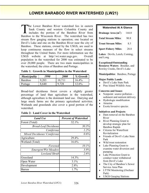
LOWER BARABOO RIVER WATERSHED (LW21)<br />
The <strong>Lower</strong> <strong>Baraboo</strong> <strong>River</strong> watershed lies in eastern<br />
Sauk County and western Columbia County and<br />
includes the portion <strong>of</strong> the <strong>Baraboo</strong> <strong>River</strong> from<br />
<strong>Baraboo</strong> to the <strong>Wisconsin</strong> <strong>River</strong>. The watershed has two<br />
stream flow gauging stations in operation; one located on<br />
Devil’s Lake and one on the <strong>Baraboo</strong> <strong>River</strong> near the city <strong>of</strong><br />
<strong>Baraboo</strong>. These stations, owned by the USGS, are used to<br />
keep continuous measure <strong>of</strong> the flow in select streams<br />
throughout the United States. For more information see the<br />
USGS website at http:\\wi.water.usgs.gov. Overall<br />
population in the watershed for 2000 was estimated to be<br />
over 20,000 people. There are two main municipalities in<br />
the watershed; the cities <strong>of</strong> <strong>Baraboo</strong> and Portage.<br />
Table 1: Growth in Municipalities in the Watershed<br />
Municipality 1990 2000 % Growth<br />
<strong>Baraboo</strong> 9,203 10,711 16.4%<br />
Portage 8,640 9,728 12.6%<br />
Broad-leaf deciduous forest covers a slightly greater<br />
percentage <strong>of</strong> land than agriculture in the watershed,<br />
although agriculture is the dominant land use. Dairying and<br />
large muck farms are the primary agricultural activities.<br />
Wetlands and grasslands also cover a good portion <strong>of</strong> the<br />
watershed.<br />
Table 2: Land Cover in the Watershed<br />
Land Use<br />
Percent <strong>of</strong> Watershed<br />
Forest (Total) 32.1%<br />
Broad-Leaf Deciduous 30.3%<br />
Coniferous 1.2%<br />
Mixed Deciduous/ Coniferous 0.6%<br />
Agriculture 29.4%<br />
Wetland (Total) 16.6%<br />
Forested 10.1%<br />
Emergent/Wet Meadow 3.9%<br />
Lowland Shrub 2.6%<br />
Grassland 14.3%<br />
Open Water 3.1%<br />
Development 2.8%<br />
Barren 1.7%<br />
Watershed At A Glance<br />
Drainage Area (m 2 ): 144.0<br />
Total Stream Miles: 90.8<br />
Trout Stream Miles: 8.5<br />
Sport Fishery Miles: 28.8<br />
Lakes: Devils, Leech, Corning,<br />
and Long<br />
Exceptional/Outstanding<br />
Resource Waters: Boulder, and<br />
Rowley Creeks, Devil’s Lake<br />
Municipalities: <strong>Baraboo</strong>, Portage<br />
Major Public Lands:<br />
♦ Devil’s Lake State Park<br />
♦ Pine Island Wildlife Area<br />
Concerns and Issues:<br />
♦ Nonpoint source pollution –<br />
sediment and nutrient delivery<br />
♦ Hydrologic modification<br />
♦ Atrazine<br />
♦ Exotic/invasive species<br />
Initiatives and Projects:<br />
♦ Dam removal on the <strong>Baraboo</strong><br />
<strong>River</strong><br />
♦ <strong>River</strong> Planning Grant to<br />
develop strategic plan for<br />
<strong>Baraboo</strong> Rapids<br />
♦ Citizens for Waterfront<br />
Revitalization<br />
♦ Friends <strong>of</strong> Devil’s Lake State<br />
Park<br />
♦ Wild trout restoration<br />
♦ Lake Planning Grant to<br />
examine water diversion and<br />
pumping<br />
♦ Lake Protection Grant to<br />
conduct water withdrawal<br />
from Devil’s Lake<br />
♦ The City <strong>of</strong> <strong>Baraboo</strong>’s Sewer<br />
Service Area Plan<br />
♦ LTTM Monitoring (Oschner<br />
Park)<br />
♦ USGS Gauging Stations<br />
<strong>Lower</strong> <strong>Baraboo</strong> <strong>River</strong> Watershed (LW21) 326
Dams have historically been a major impairment in the watershed. The impoundments<br />
created by these dams increased siltation behind the structures and warmed the water. In<br />
addition, these dams were an obstacle to fish migration. These dams, however, have since<br />
been removed. With the removal <strong>of</strong> the final dam, the Linen Mill Dam, in October <strong>of</strong> 2001,<br />
the <strong>Baraboo</strong> <strong>River</strong> is now the longest mainstream stretch <strong>of</strong> restored river in the country.<br />
Other issues that affect resources in the watershed include nonpoint sources <strong>of</strong> pollution,<br />
atrazine contamination <strong>of</strong> groundwater sources, hydrologic modification <strong>of</strong> streams and exotic<br />
and invasive species. An atrazine prohibition area is located in the area bordered to the north<br />
by the <strong>Baraboo</strong> <strong>River</strong>, to the west by Intestates 90/94 and to the east and south by the<br />
<strong>Wisconsin</strong> <strong>River</strong>. See Appendix B.<br />
The ditching and draining <strong>of</strong> wetlands to create muck farms has had a significant impact on<br />
the habitat and water quality <strong>of</strong> surface waters. These farms not only modify the hydrologic<br />
regime in a stream, but they contribute large volumes <strong>of</strong> nutrients and sediments to streams.<br />
The watershed is not ranked with respect to nonpoint source pollution priorities. The exotic<br />
and invasive garlic mustard plant is also causing some problems at Devil’s Lake State Park<br />
and in the <strong>Baraboo</strong> Bluffs. Garlic mustard is a threat to woodland areas because <strong>of</strong> its ability<br />
to displace native vegetation and can shade out tree and shrub seedlings. Another exotic,<br />
Eurasian water milfoil, has been found and is known to cause problems on the lake.<br />
In the watershed, the cities <strong>of</strong> <strong>Baraboo</strong> and Portage discharge to the <strong>Baraboo</strong> <strong>River</strong> and the<br />
<strong>Wisconsin</strong> <strong>River</strong>, respectively. Other point source discharge permittees are the Ho-Chunk<br />
Nations and J&L Oil, both <strong>of</strong> which discharge to groundwater. Teel Plastics is the only<br />
industrial discharges in the watershed and discharges to the <strong>Baraboo</strong> <strong>River</strong>.<br />
The <strong>Lower</strong> <strong>Baraboo</strong> <strong>River</strong> Watershed has a variety <strong>of</strong> good quality habitats and rare plant<br />
communities that are listed on the state’s <strong>Natural</strong> Heritage Inventory, (NHI), kept by the<br />
Bureau <strong>of</strong> Endangered <strong>Resources</strong>. Of particular interest in the watershed is the north slope <strong>of</strong><br />
the <strong>Baraboo</strong> Range, a Precambrian inlier set <strong>of</strong> hills. These hills are heavily wooded and have<br />
unique sub-ecosystems containing rare plant species. These hills have been selected as an<br />
area <strong>of</strong> significance by the Land Legacy Study, see page 63. Other interesting communities<br />
are:<br />
♦ Cedar glade ♦ Calcareous fen<br />
♦ Dry cliff ♦ Emergent aquatic<br />
♦ Dry prairie ♦ Floodplain forest<br />
♦ Glaciere talus ♦ Forested seep<br />
♦ Mesic prairie ♦ Oxbow lake<br />
♦ Moist cliff ♦ Lake—shallow, s<strong>of</strong>t, seepage<br />
♦ Northern dry forest ♦ Northern wet forest<br />
♦ Northern dry-mesic forest ♦ Shrub-carr<br />
♦ Oak opening ♦ Southern sedge meadow<br />
♦ Pine relict ♦ Springs and spring runs, s<strong>of</strong>t<br />
♦ Sand meadow ♦ Stream—fast, hard, cold<br />
♦ Southern dry forest ♦ Stream—fast, s<strong>of</strong>t, cold<br />
♦ Southern dry-mesic forest ♦ Stream—fast, s<strong>of</strong>t, warm<br />
♦ Southern mesic forest ♦ Stream—slow, s<strong>of</strong>t, warm<br />
♦ Alder thicket ♦ Wet prairie<br />
<strong>Lower</strong> <strong>Baraboo</strong> <strong>River</strong> Watershed (LW21) 327
In addition to these special communities, the watershed is also home for a variety <strong>of</strong> rare plant<br />
and animal species including; 10 species <strong>of</strong> birds, 7 species <strong>of</strong> butterflies, 5 species <strong>of</strong><br />
dragonflies, 7 species <strong>of</strong> fish, 2 species <strong>of</strong> mayflies, 6 species <strong>of</strong> mussels, 42 plant species, 2<br />
species <strong>of</strong> snakes, 1 species <strong>of</strong> turtle, 4 species <strong>of</strong> mammals, 1 species <strong>of</strong> lizard and 1 species<br />
<strong>of</strong> snail. These plants and animals are also listed on the state’s <strong>Natural</strong> Heritage Inventory<br />
(NHI).<br />
The 5,043-acre Pine Island Wildlife Area is in the watershed and <strong>of</strong>fers opportunities for<br />
canoeing and boating on the <strong>Wisconsin</strong> <strong>River</strong> in addition to dog training, hiking, and fishing.<br />
Devil’s Lake State Park is also in the watershed.<br />
RIVERS AND STREAMS IN THE WATERSHED<br />
<strong>Baraboo</strong> <strong>River</strong><br />
The <strong>Baraboo</strong> <strong>River</strong> is a warm water sport fishery and canoe trail that is tributary to the<br />
<strong>Wisconsin</strong> <strong>River</strong>. The <strong>Baraboo</strong> <strong>River</strong> has historically had up to seven dams at one time along<br />
its entire length. Most <strong>of</strong> these dams were built to generate water power, although in the past<br />
years, they have been maintained mostly for recreational purposes. As a result <strong>of</strong> the habitat<br />
fragmentation and other problems caused by the dams on the river, the two miles <strong>of</strong> the river<br />
that flows through the City <strong>of</strong> <strong>Baraboo</strong> has been listed on the state’s list <strong>of</strong> impaired water.<br />
In the past few years, there has been a strong movement to remove these dams from the river<br />
and once again open the channel up for free migration by fish, open navigation for<br />
recreational purposes, and re-establishment <strong>of</strong> the free-flowing river. The City <strong>of</strong> <strong>Baraboo</strong> in<br />
the <strong>Lower</strong> <strong>Baraboo</strong> <strong>River</strong> Watershed was the home <strong>of</strong> three <strong>of</strong> these dams. All three dams<br />
have now been removed. Prior to the removal <strong>of</strong> the third dam in October 2001, the removal<br />
<strong>of</strong> the other two opened up 5 miles <strong>of</strong> rock riffles, which had a three-fold effect:<br />
1. Increased spawning area for walleye, sturgeon, suckers (and paddlefish if they can get<br />
around Prairie du Sac dam);<br />
2. Creation <strong>of</strong> a “food factory” for the fish on the rock riffle area;<br />
3. Opening up <strong>of</strong> natural, seasonal movement throughout the <strong>Baraboo</strong> <strong>River</strong> system.<br />
It is the hope <strong>of</strong> all <strong>of</strong> the partners involved that even greater effects will be seen in the river<br />
as a result <strong>of</strong> the restoration <strong>of</strong> the river to its free-flowing condition. Monitoring will be<br />
conducted to determine the overall impact <strong>of</strong> the removal <strong>of</strong> the dams on the river. A rare<br />
aquatic species has been found in the river in past surveys. As a result <strong>of</strong> the dam removals,<br />
the process has begun to take this segment <strong>of</strong> the river <strong>of</strong>f <strong>of</strong> the list <strong>of</strong> impaired water list.<br />
The Citizens for Waterfront Revitalization have received a <strong>River</strong> Planning Grant to develop a<br />
cooperative strategic plan for the <strong>Baraboo</strong> Rapids area <strong>of</strong> the river. This area is from the<br />
Highway 12 bridge in West <strong>Baraboo</strong> to the Highway 113 bridge east <strong>of</strong> the city. The plan<br />
will address some <strong>of</strong> the watershed-wide issues that affect the river. There is a USGS gauging<br />
station near <strong>Baraboo</strong>.<br />
<strong>Lower</strong> <strong>Baraboo</strong> <strong>River</strong> Watershed (LW21) 328
Boulder Creek<br />
Boulder Creek is a Class I trout stream and an exceptional resource water (ERW). The small<br />
creek is a tributary to the <strong>Baraboo</strong> <strong>River</strong> and supports some natural reproduction <strong>of</strong> brook<br />
trout. The creek is impacted by streambank pasturing in the middle and upper portions.<br />
Baseline surveys conducted in the summer <strong>of</strong> 2000 rated the health <strong>of</strong> the warm water fishery<br />
to be fair and the health <strong>of</strong> the cold water fishery to be good.<br />
Leech Creek<br />
Leech Creek is a tributary to the <strong>Baraboo</strong> <strong>River</strong>. Just over 2.5 miles are classified as a Class<br />
II trout stream and the stream supports some natural reproduction <strong>of</strong> both brook and brown<br />
trout. The lower half <strong>of</strong> the stream could possibly have trout stream potential, but has been<br />
extensively ditched and straightened. There is a muck farm on a portion <strong>of</strong> the creek that is a<br />
source <strong>of</strong> sediments and nutrients. There are currently no plans to remove the farm. Surveys<br />
<strong>of</strong> the warm water fish communities have found it to be in fair condition.<br />
Rowley Creek<br />
Rowley Creek begins in Columbia County. The creek has a good gradient from the Sauk<br />
County line to the <strong>Baraboo</strong> <strong>River</strong>. The creek has an excellent brook and brown trout fishery<br />
and the lower 2.7 miles <strong>of</strong> Rowley Creek are considered a Class I trout stream and an<br />
exceptional resource water (ERW). The 2 miles upstream <strong>of</strong> this are Class II trout waters and<br />
also an ERW. Baseline surveys conducted in the summer <strong>of</strong> 2000 found the warm water and<br />
cold water fisheries to be in good health.<br />
<strong>Wisconsin</strong> <strong>River</strong><br />
A portion <strong>of</strong> the <strong>Wisconsin</strong> <strong>River</strong> flows through this watershed. For more information on the<br />
<strong>Wisconsin</strong> <strong>River</strong>, see page 90.<br />
LAKE IN THE WATERSHED<br />
Devils Lake<br />
Devils Lake is a seepage lake in Devils Lake State Park. The lake is a popular recreation area<br />
and has a diverse sport fishery. The lake can support a two-story brown trout fishery. Six feet<br />
below the thermocline, the water still has enough oxygen to support a population <strong>of</strong> brown<br />
trout. Devils Lake is oligotrophic and usually has excellent water clarity. The lake is<br />
designated an outstanding resource water (ORW).<br />
Problems in the lake are due to high levels <strong>of</strong> phosphorus, the prevalence <strong>of</strong> an invasive exotic<br />
plant species, and the presence <strong>of</strong> mercury in the water column. A fish consumption advisory<br />
exists on the lake for walleye due to the levels <strong>of</strong> mercury found in the fish’s tissue samples.<br />
The sources <strong>of</strong> the mercury are unknown, but may be naturally occurring or come from<br />
airborne deposition. Core sampling <strong>of</strong> bottom sediments in 1987 yielded little conclusive<br />
information. In addition, beds <strong>of</strong> Eurasian milfoil, an undesirable exotic plant species, have<br />
become problematic on the lake. High levels <strong>of</strong> phosphorus have also been attributed to this<br />
and other problems in the lake’s ecosystem. One <strong>of</strong> these other problems is the presence <strong>of</strong><br />
the parasite that causes swimmer’s itch. It is suspected that this parasite lives on snails that<br />
feed on the algae that grows in the lake because <strong>of</strong> the phosphorus.<br />
<strong>Lower</strong> <strong>Baraboo</strong> <strong>River</strong> Watershed (LW21) 329
Starting in 2002 and running for 10 – 15 years, the <strong>Department</strong> will be conducting a bottom<br />
draw program every September through December to remove oxygen depleted water, which is<br />
the direct result <strong>of</strong> high phosphorus levels, from the bottom <strong>of</strong> the lake through a<br />
hypolimnetic withdrawal. This project will hopefully do 5 main things:<br />
1. Decrease periphyton growth on rocks<br />
2. Decrease filamentous algae growth in lake shallows<br />
3. Decrease snails that feed on these algae and therefore, decrease the number <strong>of</strong> hosts<br />
for the parasite that causes Swimmer’s Itch.<br />
4. Improve aquatic habitat for the lake’s brown trout population that is currently in<br />
danger as a result <strong>of</strong> the low oxygen levels<br />
5. Decrease the amount <strong>of</strong> time that mercury in bottom sediments can methalize and<br />
bioaccumulate in aquatic species.<br />
Since the lake is fed mostly by groundwater seeps and through precipitation, this withdrawal<br />
<strong>of</strong> water does have the potential to lower the lakes level. This problems has been addressed<br />
and it is planned to re-charge the lake through the re-connection <strong>of</strong> a previously diverted<br />
stream. This project is funded through a Lake Planning and a Lake Protection Grant. There is<br />
a USGS gauging station on Devil’s Lake.<br />
Long Lake<br />
Long Lake is a fairly shallow lake located in Columbia County. It is a meander lake <strong>of</strong> the<br />
<strong>Wisconsin</strong> <strong>River</strong> and although the lake is normally landlocked, it does receive floodwaters<br />
from the river. The fishery in the lake is comprised mainly <strong>of</strong> panfish, although some river<br />
species can occasionally be found as a result <strong>of</strong> this flooding.<br />
Silver Lake<br />
This lake is located on the terminal moraine in Portage. The landlocked lake is approximately<br />
74 acres. The lake experiences some problems as a result <strong>of</strong> weed growth and stunted panfish<br />
populations. The fishery in the lake is largemouth bass, panfish and northern pike.<br />
RECOMMENDATIONS (LW21)<br />
♦<br />
♦<br />
♦<br />
♦<br />
♦<br />
An investigation should be conducted to determine a way, other than through the use <strong>of</strong><br />
chemicals or machines, to reduce undesirable aquatic plant beds, such as Eurasian water<br />
milfoil, in Devils Lake.<br />
Additional lake bottom sediment monitoring in Devils Lake should be completed to<br />
determine if elevated levels <strong>of</strong> mercury or other toxic substances exist.<br />
Baseline monitoring on Leech Creek should be conducted.<br />
The fish in Devil's Lake and the <strong>Baraboo</strong> <strong>River</strong> above and below the city <strong>of</strong> <strong>Baraboo</strong><br />
should be monitored to determine the presence <strong>of</strong> toxic substances.<br />
Leech Creek should be re-meandered to establish a healthy trout stream.<br />
<strong>Lower</strong> <strong>Baraboo</strong> <strong>River</strong> Watershed (LW21) 330
♦<br />
♦<br />
♦<br />
♦<br />
Public funding from the state and from federal 314 money should be sought to fund lake<br />
protection programs that focus on decreasing the input <strong>of</strong> nutrients to lakes, such as<br />
Devil’s Lake.<br />
The <strong>Baraboo</strong> <strong>River</strong> should be surveyed to determine if rare aquatic elements previously<br />
found in the river is still present.<br />
Improve northern pike spawning habitat near the mouth <strong>of</strong> the <strong>Baraboo</strong> <strong>River</strong>.<br />
Opportunities for canoeing on the <strong>Baraboo</strong> <strong>River</strong> should be improved.<br />
<strong>Lower</strong> <strong>Baraboo</strong> <strong>River</strong> Watershed (LW21) 331
Watershed map<br />
<strong>Lower</strong> <strong>Baraboo</strong> <strong>River</strong> Watershed (LW21) 332
Streams in the <strong>Lower</strong> <strong>Baraboo</strong> <strong>River</strong> Watershed (LW21) Sauk and Columbia Counties Area: 144 sq miles<br />
Stream Name WBIC<br />
Length<br />
(miles)<br />
Existing<br />
Use<br />
Potential<br />
Use<br />
Supporting<br />
Potential Use<br />
Codified Use and<br />
Trout Stream<br />
Classification<br />
Proposed<br />
Codified Use<br />
303(d)<br />
Status<br />
Rare<br />
Aquatic<br />
Species<br />
Use Impairment<br />
Source Impact<br />
NPS<br />
Rank<br />
Monitored/<br />
Evaluated/<br />
Unassessed<br />
Data<br />
Level<br />
Trend Ref.*<br />
<strong>Baraboo</strong> <strong>River</strong> 1271100 28.8 WWSF same Part WWSF same Y/2 Y<br />
NPS, PSM,<br />
PSI, SB, HM<br />
HAB M M B2 U<br />
4, 5, 15,<br />
16, 19<br />
Boulder Creek 1273200 0-1.2 COLD I same Full COLD I/ERW same N N PSB HAB M M (2000) B4, H1 U 5, 19<br />
1.2-3 COLD same Part ERW same N U<br />
Leech Creek 1271600 0-4.7 WWFF COLD II Not DEF same N N HM HAB H M B2 U<br />
4, 5, 15,<br />
19<br />
4.7-7.3 COLD II same Part COLD II same N PSB, BDAM HAB U<br />
Rowley Creek 1272100 0-2.7 COLD I same Full COLD I/ERW same N N NPS, BDAM HAB M M (2000) B4, H1 U 5, 15, 19<br />
2.7-4.7 COLD II same Part DEF/ERW COLD II N U<br />
4.7-8 WWFF same Part DEF/ERW same N U<br />
Unnamed streams 43.7 DEF<br />
Total Stream Miles 90.8<br />
COLD 1.8<br />
COLD I 3.9<br />
COLD II 4.6<br />
WWSF 28.8<br />
WWFF 12.7<br />
U 43.7<br />
*The numbers in this column refer to the References found in the corresponding Watershed Narrative.<br />
See Appendix J: "How to Read the Stream Tables," in Chapter 7 <strong>of</strong> the State <strong>of</strong> the <strong>Lower</strong> <strong>Wisconsin</strong> <strong>River</strong> Basin Report.<br />
<strong>Lower</strong> <strong>Baraboo</strong> <strong>River</strong> Watershed (LW21) 333
Lakes in the <strong>Lower</strong> <strong>Baraboo</strong> <strong>River</strong> Watershed (LW21) Sauk and Columbia Counties<br />
Lake Name WBIC County<br />
Surface<br />
Area<br />
(Acres)<br />
Max<br />
Depth<br />
Lake<br />
Type<br />
Winterkill Access SH Hg MAC LMO TSI<br />
Lake Plan or<br />
Prot<br />
P Sens Comments<br />
Corning Lake 1294900 Columbia 27 4 SE NW 2<br />
Devils Lake 980900 Sauk 369 47 SE N BR C M EWM 31 PROT/ PLAN 1<br />
lakes planning grant<br />
proj.<br />
Long Lake 1000700 Columbia 69 20 SE N BR 2<br />
See Appendix K: "How to Read the Lake Tables," in Chapter 7 <strong>of</strong> the <strong>Lower</strong> <strong>Wisconsin</strong> State <strong>of</strong> the Basin Report.<br />
<strong>Lower</strong> <strong>Baraboo</strong> <strong>River</strong> Watershed (LW21) 334
REFERENCES<br />
1. Ball, Joseph R. , Tom Smith, C.W. Threinen. Surface Water <strong>Resources</strong> <strong>of</strong> Sauk County.<br />
<strong>Department</strong> <strong>of</strong> <strong>Natural</strong> <strong>Resources</strong>. 1971.<br />
2. Enterprise Information, Technology and Applications, Bureau <strong>of</strong>. <strong>Wisconsin</strong> DNR. The<br />
WISCLAND Land Cover Data. Data from 1991 to 1993. Published in 1998.<br />
3. Enterprise Information, Technology and Applications, Bureau <strong>of</strong>. <strong>Wisconsin</strong> DNR.<br />
User’s Guide to WISCLAND Land Cover Data. 1998.<br />
4. Fix, Steve. <strong>Lower</strong> <strong>Wisconsin</strong> <strong>River</strong> Basin Water Quality Management Plan. <strong>Wisconsin</strong><br />
<strong>Department</strong> <strong>of</strong> <strong>Natural</strong> <strong>Resources</strong>. PUBL-WR-001-94-REV. 1994.<br />
5. Larson, Tim. Personal Communications. <strong>Wisconsin</strong> <strong>Department</strong> <strong>of</strong> <strong>Natural</strong> <strong>Resources</strong>.<br />
2000 - 2001.<br />
6. Marshall, Dave. Personal Communications. <strong>Wisconsin</strong> <strong>Department</strong> <strong>of</strong> <strong>Natural</strong><br />
<strong>Resources</strong>. 2000 - 2001.<br />
7. Morton, Andy. <strong>Baraboo</strong> <strong>River</strong> Dam Removal and Restoration Project. Unpublished.<br />
<strong>Wisconsin</strong> <strong>Department</strong> <strong>of</strong> <strong>Natural</strong> <strong>Resources</strong>. 2000.<br />
8. Morton, Andy. Personal Communications. <strong>Wisconsin</strong> <strong>Department</strong> <strong>of</strong> <strong>Natural</strong> <strong>Resources</strong>.<br />
2000 - 2001.<br />
9. North Central <strong>Wisconsin</strong> Regional Planning Commission. Watershed Population<br />
Estimates for the State <strong>of</strong> <strong>Wisconsin</strong>. May 2000.<br />
10. Osip<strong>of</strong>f, George. Personal Communications. <strong>Wisconsin</strong> <strong>Department</strong> <strong>of</strong> <strong>Natural</strong><br />
<strong>Resources</strong>. 2000.<br />
11. P<strong>of</strong>f, Ronald and C.W. Threinen. Surface Water <strong>Resources</strong> <strong>of</strong> Columbia County.<br />
<strong>Wisconsin</strong> <strong>Department</strong> <strong>of</strong> <strong>Natural</strong> <strong>Resources</strong>. 1965.<br />
12. United States Geological Survey. Water <strong>Resources</strong> <strong>of</strong> <strong>Wisconsin</strong> Website.<br />
http:\\wi.water.usgs.gov.<br />
13. <strong>Wisconsin</strong> <strong>Department</strong> <strong>of</strong> Administration. Population Projections and Census 2000<br />
websites, Http://www.doa.state.wi.us/dhir/boir/demographic/pop_proj.asp. Last updated<br />
August 2000.<br />
14. <strong>Wisconsin</strong> <strong>Department</strong> <strong>of</strong> Agriculture, Trade and Consumer Protection (WDATCP).<br />
Atrazine Prohibition Web site, http://datcp.state.wi.us/arm/agriculture/pest-fert/atrazine/<br />
and ATCP 30, <strong>Wisconsin</strong> Administrative Code. 2001.<br />
15. <strong>Wisconsin</strong> <strong>Department</strong> <strong>of</strong> <strong>Natural</strong> <strong>Resources</strong>. Fish Management Files, Southcentral<br />
Region. Through 2000.<br />
16. <strong>Wisconsin</strong> <strong>Department</strong> <strong>of</strong> <strong>Natural</strong> <strong>Resources</strong>. Water <strong>Resources</strong> Management Files –<br />
South Central Region. 2001.<br />
17. <strong>Wisconsin</strong> DNR. <strong>Wisconsin</strong> DNR’s Public Wildlife Recreation Land. PUBL-WM-001-<br />
98. 1998.<br />
18. <strong>Wisconsin</strong> DNR. <strong>Wisconsin</strong> Lakes. Bureau <strong>of</strong> Water <strong>Resources</strong> Management and Bureau<br />
<strong>of</strong> Fisheries Management. 1995.<br />
19. <strong>Wisconsin</strong> <strong>Department</strong> <strong>of</strong> <strong>Natural</strong> <strong>Resources</strong>. Fisheries Management, Bureau <strong>of</strong>.<br />
<strong>Wisconsin</strong> Trout Streams. 1980.<br />
<strong>Lower</strong> <strong>Baraboo</strong> <strong>River</strong> Watershed (LW21) 335
![Nature program winter schedule [PDF] - Wisconsin DNR](https://img.yumpu.com/22471254/1/190x245/nature-program-winter-schedule-pdf-wisconsin-dnr.jpg?quality=85)
![City of Middleton [PDF] - Wisconsin Department of Natural Resources](https://img.yumpu.com/22300392/1/190x245/city-of-middleton-pdf-wisconsin-department-of-natural-resources.jpg?quality=85)
![Wetland Conservation Activities [PDF] - Wisconsin Department of ...](https://img.yumpu.com/21975633/1/190x245/wetland-conservation-activities-pdf-wisconsin-department-of-.jpg?quality=85)
![Baraboo River Region[PDF] - Wisconsin Department of Natural ...](https://img.yumpu.com/21975619/1/190x245/baraboo-river-regionpdf-wisconsin-department-of-natural-.jpg?quality=85)