Cities (PDF, 295KB) - Wisconsin Department of Natural Resources
Cities (PDF, 295KB) - Wisconsin Department of Natural Resources
Cities (PDF, 295KB) - Wisconsin Department of Natural Resources

Create successful ePaper yourself
Turn your PDF publications into a flip-book with our unique Google optimized e-Paper software.
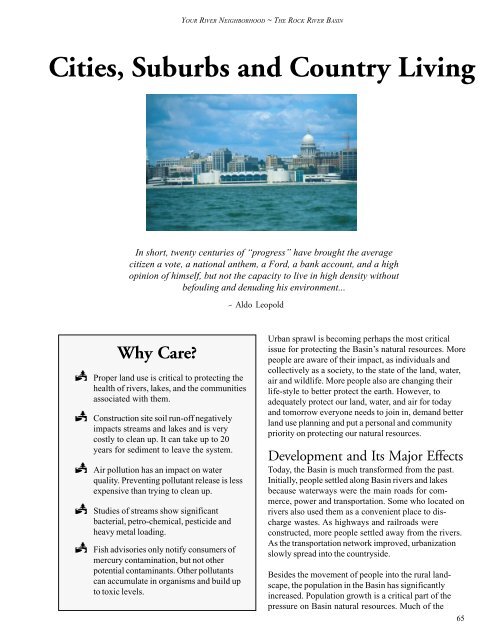
YOUR RIVER NEIGHBORHOOD ~ THE ROCK RIVER BASIN<br />
<strong>Cities</strong>, Suburbs and Country Living<br />
In short, twenty centuries <strong>of</strong> “progress” have brought the average<br />
citizen a vote, a national anthem, a Ford, a bank account, and a high<br />
opinion <strong>of</strong> himself, but not the capacity to live in high density without<br />
befouling and denuding his environment...<br />
~ Aldo Leopold<br />
Why Care?<br />
2 Proper land use is critical to protecting the<br />
health <strong>of</strong> rivers, lakes, and the communities<br />
associated with them.<br />
2 Construction site soil run-<strong>of</strong>f negatively<br />
impacts streams and lakes and is very<br />
costly to clean up. It can take up to 20<br />
years for sediment to leave the system.<br />
2 Air pollution has an impact on water<br />
quality. Preventing pollutant release is less<br />
expensive than trying to clean up.<br />
2 Studies <strong>of</strong> streams show significant<br />
bacterial, petro-chemical, pesticide and<br />
heavy metal loading.<br />
2 Fish advisories only notify consumers <strong>of</strong><br />
mercury contamination, but not other<br />
potential contaminants. Other pollutants<br />
can accumulate in organisms and build up<br />
to toxic levels.<br />
Urban sprawl is becoming perhaps the most critical<br />
issue for protecting the Basin’s natural resources. More<br />
people are aware <strong>of</strong> their impact, as individuals and<br />
collectively as a society, to the state <strong>of</strong> the land, water,<br />
air and wildlife. More people also are changing their<br />
life-style to better protect the earth. However, to<br />
adequately protect our land, water, and air for today<br />
and tomorrow everyone needs to join in, demand better<br />
land use planning and put a personal and community<br />
priority on protecting our natural resources.<br />
Development and Its Major Effects<br />
Today, the Basin is much transformed from the past.<br />
Initially, people settled along Basin rivers and lakes<br />
because waterways were the main roads for commerce,<br />
power and transportation. Some who located on<br />
rivers also used them as a convenient place to discharge<br />
wastes. As highways and railroads were<br />
constructed, more people settled away from the rivers.<br />
As the transportation network improved, urbanization<br />
slowly spread into the countryside.<br />
Besides the movement <strong>of</strong> people into the rural landscape,<br />
the population in the Basin has significantly<br />
increased. Population growth is a critical part <strong>of</strong> the<br />
pressure on Basin natural resources. Much <strong>of</strong> the<br />
65
YOUR RIVER NEIGHBORHOOD ~ THE ROCK RIVER BASIN<br />
population growth has been in suburban areas surrounding<br />
cities and towns and paralleling major roadways.<br />
Growth and economic development has brought<br />
many benefits to the Basin citizens. The price has been<br />
significant in terms <strong>of</strong> the ecological health <strong>of</strong> the<br />
Basin’s environment.<br />
Most <strong>of</strong> the urban growth is at the cost <strong>of</strong> the Basin’s<br />
agricultural production and wildlife habitat. The Rock<br />
River Basin contains some <strong>of</strong> the most productive<br />
agricultural soil in <strong>Wisconsin</strong>. These irreplaceable lands<br />
are being converted to areas for housing and businesses.<br />
Map 13 shows sales <strong>of</strong> agriculture land in our<br />
Basin that was sold for other uses - mostly development.<br />
The magnitude <strong>of</strong> the loss and the pattern points<br />
out the vulnerability <strong>of</strong> the Basin’s agricultural base -<br />
and the vulnerability <strong>of</strong> habitat for many wildlife species<br />
whose habitat is rurally dependent. The graphic also<br />
shows areas where concentrated efforts and programs<br />
can protect remaining valuable agricultural areas. Most<br />
land lost to agriculture and wildlife habitat is irreplaceable<br />
because land developed for homes, businesses, or<br />
transportation will unlikely ever return to food production<br />
or to support wildlife.<br />
In 1995, the DNR, recognizing that land use is the<br />
critical issue for protecting the natural resources in<br />
<strong>Wisconsin</strong>, developed a report Common Ground,<br />
outlining a strategic direction for the DNR in land use<br />
planning. The report focuses on DNR programs and<br />
policies. The goal was to help improve both DNR’s<br />
land use decision-making and its assistance to local<br />
governments and private landowners on land use and<br />
natural resource issues. The report was the DNR’s<br />
initial contribution to the work <strong>of</strong> the Interagency Land<br />
Uses Council and <strong>Wisconsin</strong> Strategic Growth Task<br />
Force, which were established by former Governor<br />
Tommy Thompson in 1994. As a result <strong>of</strong> these initiatives,<br />
land use and its relationship to natural resources<br />
and other important issues has become as important<br />
part <strong>of</strong> policy and planning at many different levels <strong>of</strong><br />
government across <strong>Wisconsin</strong>.<br />
Impacts on Water Quality<br />
Development increases run<strong>of</strong>f. The run<strong>of</strong>f delivers<br />
large quantities <strong>of</strong> pollutants into rivers and lakes.<br />
Impervious surfaces like streets, parking lots, driveways<br />
and ro<strong>of</strong>s, rapidly direct stormwater and its urban<br />
pollutants directly into rivers and lakes. The pollutants<br />
<strong>of</strong>ten include significant quantities <strong>of</strong> sediment, nutrients,<br />
heavy metals and petroleum-related products<br />
associated with vehicle traffic and also high bacteria<br />
loads (sources include livestock and pet waste and<br />
sometimes wildlife). Urban stormwater run<strong>of</strong>f can<br />
have greater impact on local rivers and lakes than<br />
pollutants from agriculture or other nonpoint source<br />
run<strong>of</strong>f.<br />
One unsuspected source <strong>of</strong> polluted urban run<strong>of</strong>f is<br />
lawns. To many people’s surprise, lawns, while better<br />
than pavement, do not infiltrate water very well. In<br />
addition, from a chemical use perspective, lawns are<br />
becoming our number one “agricultural crop”. More<br />
fertilizer and pesticides are used per acre on lawns than<br />
on farm crops. Unfortunately many lawn owners share<br />
a belief that - if a little is good, a lot is better. Fertilizer<br />
and pesticides applied in excess <strong>of</strong> plant needs -<br />
whether on lawns or farm fields, can simply wash <strong>of</strong>f<br />
into rivers and lakes or filter into the groundwater. A<br />
soil test taken by the landowner will indicate if nutrients<br />
are lacking in lawn or garden soil.<br />
For more information on toxics in waterways:<br />
http://toxics.usgs.gov/regional/emc.html<br />
Sediment from construction sites is a major source <strong>of</strong><br />
pollutants in urban areas. Information gathered in the<br />
Lake Mendota Nonpoint Priority Watershed project<br />
showed that on average only about 450 acres <strong>of</strong> land in<br />
the 148,751 acre (232 square miles) watershed is bare<br />
at one time because <strong>of</strong> construction. However, this<br />
small land area contributes about 20% <strong>of</strong> the total<br />
phosphorus and sediment entering Lake Mendota every<br />
year (respectively 72,275 pounds and 9,613 tons).<br />
Other priority watershed project have also found that<br />
uncontrolled construction sites give <strong>of</strong>f large volumes <strong>of</strong><br />
sediment during storms.<br />
DNR and the <strong>Department</strong> <strong>of</strong> Commerce (DOC)<br />
regulate many construction activities in the state.<br />
However, local government ordinances are needed to<br />
cover certain activities not covered by state regulations.<br />
Local governmental programs are also important to<br />
ensure on-site compliance with environmental rules.<br />
Other potential sources <strong>of</strong> urban run<strong>of</strong>f pollution include<br />
industrial sites, where outside activities and storage <strong>of</strong><br />
materials can contaminate stormwater run<strong>of</strong>f. Some <strong>of</strong><br />
these industrial facilities are regulated by the DNR<br />
through industrial stormwater permits. Where state<br />
regulations do not apply, local government programs<br />
may be necessary to control industrial pollution sources.<br />
66
YOUR RIVER NEIGHBORHOOD ~ THE ROCK RIVER BASIN<br />
Map 13: Agricultural Land Sold out <strong>of</strong> Ag<br />
Production in the Rock River Basin<br />
Please refer to the State <strong>of</strong> the Rock River<br />
Basin Report web page to view this map<br />
67
YOUR RIVER NEIGHBORHOOD ~ THE ROCK RIVER BASIN<br />
Rain Gardens<br />
Improving water quality at home!<br />
Run<strong>of</strong>f from house ro<strong>of</strong>tops, lawns, and driveways carry pollutants. These pollutants reach rivers<br />
and lakes and cause excessive weeds, turbid water, a build-up <strong>of</strong> sediment and sometimes, beach<br />
closures. With a rain garden you can reduce run<strong>of</strong>f and pollutants, provide wildlife habitat, and<br />
beautify your home at the same time.<br />
A rain garden is a relatively small area planted near the drain spout <strong>of</strong> a house or building or near a<br />
paved area (such as a driveway). The water from a rain storm or from snowmelt is routed to the<br />
rain garden and is filtered naturally by the garden’s plants and soils. This filtration process removes<br />
nutrients and pollutants. It also helps restore natural infiltration into groundwater.<br />
Rain gardens use the concept <strong>of</strong> bioretention, a practice in which plants and soils help remove<br />
pollutants from stormwater. Rain gardens can utilize a wide range <strong>of</strong> plants (preferably native<br />
species), as well as trees and shrubs. Each rain garden plot covers about 200 square feet and is<br />
designed so water will not pond in the garden for more than 24 hours. Some yards can use two or<br />
more rain gardens!<br />
The benefits <strong>of</strong> rain gardens are they:<br />
2<br />
2<br />
2<br />
2<br />
Require only occasional weeding and reduce the amount <strong>of</strong> lawn you need to mow<br />
so you’ll spend more time relaxing and enjoying your property.<br />
Slow the flow <strong>of</strong> water <strong>of</strong>f property, which can deter flash flooding.<br />
Attract birds and butterflies.<br />
Help recharge and renew neighborhood groundwater.<br />
Rain gardens beautify your property and helps ensure that we have clean water now and in the<br />
future. To learn more about rain gardens write to the address listed below and ask for publication<br />
number PUB-WT-702-00.<br />
WI DNR<br />
Run<strong>of</strong>f Management, WT/2<br />
PO Box 7921<br />
Madison, WI 53707-7921<br />
68
YOUR RIVER NEIGHBORHOOD ~ THE ROCK RIVER BASIN<br />
In the early 1990s, the U.S. Environmental Protection<br />
Agency (EPA), recognizing that pollutants carried by<br />
urban run<strong>of</strong>f are a major source <strong>of</strong> water quality<br />
contamination, developed federal regulations requiring<br />
the largest municipalities in the U.S. (those greater than<br />
100,000 population) to control urban run<strong>of</strong>f pollution.<br />
The authority to implement a water permitting program<br />
is delegated to the DNR. Under the state’s municipal<br />
stormwater water program, the City <strong>of</strong> Madison and<br />
the UW-Madison received a municipal stormwater<br />
water discharge permit. Because other municipalities<br />
are connected to Madison’s storm sewer system or<br />
have similar urban impacts on nearby waterways, 17<br />
adjacent cities, villages, towns, and Dane County are<br />
also required to obtain a municipal stormwater discharge<br />
permit.<br />
In October 1999, the EPA passed new regulations<br />
requiring smaller municipalities to obtain stormwater<br />
discharge permits. The new Basin areas covered under<br />
the municipal stormwater program include the Beloit<br />
and Janesville Urbanized Areas. The U.S. Census<br />
Bureau’s definition <strong>of</strong> these Urbanized Areas includes a<br />
number <strong>of</strong> townships or parts <strong>of</strong> townships adjacent to<br />
Beloit and Janesville. Other cities in the Basin that<br />
have a population <strong>of</strong> 10,000 or greater will need to be<br />
evaluated by the DNR to determine if they should<br />
receive stormwater discharge permits. These include<br />
the <strong>Cities</strong> <strong>of</strong> Beaver Dam, Fort Atkinson, Watertown<br />
and Whitewater. Additional cities may need evaluation<br />
based on the 2000 census updated by the U.S. Bureau<br />
<strong>of</strong> Census.<br />
The EPA leaves it up to the state to evaluate a municipality<br />
with a population less than 10,000 to determine if<br />
it should receive a stormwater discharge permit. As<br />
the regulations are implemented in <strong>Wisconsin</strong> in the<br />
next few years, many additional Basin communities will<br />
be intensifying their efforts to control urban run<strong>of</strong>f.<br />
For information on Urban Stormwater Program:<br />
www.epa.nsw.gov/au/stormwater/usp.htm<br />
Besides the direct environmental impact <strong>of</strong> urban<br />
sprawl, it also significantly increases the demand for<br />
transportation infrastructure, solid and wastewater<br />
disposal, recreation and it results in loss and fragmentation<br />
<strong>of</strong> wildlife habitat. These less visible demands <strong>of</strong><br />
sprawl - many <strong>of</strong> them the result <strong>of</strong> homes being built<br />
away from city services - place pressure on our natural<br />
resources. These pressures must be considered in<br />
order to insure a healthy environment for people today<br />
and in the future.<br />
Typically costs for public services are higher for<br />
developments in rural areas. Because <strong>of</strong> the increased<br />
distance between each subdivisions, rural development<br />
can result in higher costs for providing roads, garbage<br />
pick up, law enforcement and fire protection than for<br />
the same services in cities. Public sewer and water<br />
services are <strong>of</strong>ten too costly to provide in rural subdivisions<br />
or industrial parks.<br />
The greater cost incurred by developers for construction<br />
<strong>of</strong> rural subdivisions are passed on to the home<br />
buyers through the cost <strong>of</strong> the lots. The full cost <strong>of</strong> the<br />
services <strong>of</strong>ten times are not just borne by the new<br />
homeowner, other area residents also help pay for<br />
public services provided to new rural development. The<br />
increased cost <strong>of</strong> services such as law enforcement,<br />
garbage pickup, snow removal, fire protection, road<br />
maintenance and schools usually result in increased<br />
town or county taxes to the current residents in the tax<br />
district. These costs can play a significant role in<br />
changing the revenue and costs relationship for townships<br />
and county governments and tax paying residents.<br />
A Cost <strong>of</strong> Community Services (COCS) study, conducted<br />
by the <strong>Wisconsin</strong> Land Use Research Program,<br />
University <strong>of</strong> <strong>Wisconsin</strong>-Madison in May 2000, attempted<br />
to show how different types <strong>of</strong> land use affect<br />
a community’s budget <strong>of</strong> costs and revenues. The<br />
Township <strong>of</strong> Dunn, located in Dane County in the<br />
Basin, was one <strong>of</strong> communities studied.<br />
The study showed that the cost <strong>of</strong> town and school<br />
services slightly exceeded the revenue produced by the<br />
new residences. The study concluded that, while the<br />
data was generated from specific communities, the<br />
general trends may be applicable to a broad range <strong>of</strong><br />
<strong>Wisconsin</strong> communities. It also emphasized that not any<br />
one type <strong>of</strong> land use is better or worse, but that the<br />
long-term fiscal health <strong>of</strong> any community needs a<br />
balance <strong>of</strong> land uses. The study showed the importance<br />
<strong>of</strong> townships and counties assessing both the revenues<br />
and costs <strong>of</strong> all development along with other social<br />
changes and impacts to the environment.<br />
69
YOUR RIVER NEIGHBORHOOD ~ THE ROCK RIVER BASIN<br />
Flooding and Erosion Impacts<br />
Increased run<strong>of</strong>f from development plays an important<br />
role in flooding and erosion problems in streams and<br />
lakes. The Rock River Basin has numerous low-lying<br />
areas prone to flooding. Growing populations located<br />
along or near rivers and lakes result in more problems<br />
associated with flooding. Accompanying the flooding<br />
are calls to local and state <strong>of</strong>ficials “What are you<br />
going to do to help me get the water <strong>of</strong>f my land?”<br />
Several factors play a role in why parts <strong>of</strong> our Basin<br />
repeatedly flood:<br />
2<br />
2<br />
2<br />
2<br />
2<br />
The Basin has lost over 50% <strong>of</strong> its wetlands.<br />
Increasing urbanization is bringing increased<br />
impervious acres and storm sewers, which<br />
more rapidly deliver water to streams.<br />
The low gradient <strong>of</strong> many Basin rivers<br />
results in large flood events needing more<br />
time to leave the Basin - meanwhile water<br />
backs up on low-lying lands.<br />
Many rural, suburban, and urban landowners<br />
live on or near lands that historically were<br />
wetlands and floodplains.<br />
More people are building near water bodies.<br />
Historically flooding in rural areas has been fairly<br />
consistent in area and scope. However, urban flooding<br />
is increasing. In recent years the Basin has experienced<br />
more or larger storms. Increased impervious<br />
area have caused higher water levels. Streams have<br />
become more flashy (flooding faster and deeper).<br />
Increased water energy attacks shorelines with heightened<br />
intensity. Homes, businesses, parks and productive<br />
farmland are threatened and irreplaceable<br />
shoreland is lost - which also means tons <strong>of</strong> sediment<br />
entering streams and lakes along with more nutrients to<br />
feed algae growth.<br />
To help control urban and rural flood damage, flood<br />
plain zoning is administrated through county or city<br />
government agencies. Many areas in the Basin have<br />
Federal Flood Boundary and Floodway maps available.<br />
These maps are produced by the Federal Emergency<br />
Management Agency (FEMA) and are available<br />
through FEMA or your local zoning agency.<br />
In 1993, the Basin experienced more serious widescale<br />
flooding. In Jefferson County near the City <strong>of</strong><br />
Fort Atkinson and Lake Koshkonong, a large Rock<br />
River flood resulted in over 50 homes with flood<br />
damage. Many people were unable to access their<br />
homes and lands for up to 6 weeks. The total landowner<br />
flood costs was estimated to be over $500,000.<br />
Besides the direct costs to landowners, Jefferson<br />
County had other significant flood-related costs. More<br />
recently in 2000, many areas in Waukesha County,<br />
Dane County, and the <strong>Cities</strong> <strong>of</strong> Madison, Monona and<br />
Middleton experienced considerable flooding due to a<br />
series <strong>of</strong> extreme storm events.<br />
In Jefferson County, to comply with the requirements<br />
<strong>of</strong> receiving 1993 federal disaster relief funding, the<br />
county was required to develop a County Flood Mitigation<br />
Plan. The plan helps control floodwater impacts to<br />
some <strong>of</strong> the most flood prone areas in the county.<br />
Through the plan and with federal and state funding the<br />
county purchased a number <strong>of</strong> very flood prone properties<br />
near Blackhawk Island on Lake Koshkonong.<br />
These properties from the perspective <strong>of</strong> flood potential<br />
and societal costs should not have been developed in<br />
the first place and are a warning to others trying to<br />
build in low areas.<br />
Dams<br />
Currently, there are about 194 dams <strong>of</strong> varying sizes in<br />
the Basin. Many dams were initially built to power local<br />
industries, which typically included grinding wheat or<br />
cutting logs. Dams were also constructed to control<br />
water levels in natural lakes. Some dams were constructed<br />
to control floods or to provide habitat for<br />
wildlife, such as the Horicon Marsh and Theresa<br />
Marsh dams. Many rivers in the Basin, especially the<br />
main stem <strong>of</strong> the Rock River, have a series <strong>of</strong> dams<br />
and lake impoundments.<br />
Some <strong>of</strong> the larger dams in the Basin were converted<br />
to hydroelectric generation. Today, seven dams produce<br />
electricity. Four are regulated by the Federal Energy<br />
Regulation Commission (FERC). The DNR regulates<br />
the remaining three dams. Four hydro dams may be<br />
renovated to again produce power and if they are, they<br />
will be FERC regulated. As time passed, many <strong>of</strong> the<br />
dams in the Basin became used primarily for recreation,<br />
wildlife, and aesthetic and scenic benefit to area<br />
residents.<br />
70
YOUR RIVER NEIGHBORHOOD ~ THE ROCK RIVER BASIN<br />
Dams have significant environment impacts. Often the<br />
negative effects may be greater than the beneficial<br />
effects <strong>of</strong> a dam. Dams transform a river ecosystem<br />
into a lake ecosystem with the change affecting all the<br />
species living in the water and along the shorelines.<br />
Eventually the reservoirs behind dams fill up with soil<br />
washing down the river and settling behind the dam,<br />
affecting water quality and reducing the impoundment’s<br />
water holding capacity. Dams prevent fish migration to<br />
their spawning areas and wintering habitat.<br />
Water level control at a dam <strong>of</strong>ten involves conflicting<br />
needs and desires from the public, especially during<br />
high water. The agricultural sector wants dams lowered<br />
to allow water to drain farm fields, especially during<br />
floods. People who live on impoundments lose recreational<br />
lake usage when water levels are low and<br />
frequently want dams raised to increase water levels.<br />
The fishing and hunting community and industries have<br />
equally valid reasons for wanting water levels that meet<br />
their particular needs.<br />
Water level management in impoundments is particularly<br />
challenging in our Basin due to very shallow water<br />
depths and sediment acculations.<br />
Dams, like all human built structures, deteriorate over<br />
time and must be maintained. The DNR monitors the<br />
structural integrity <strong>of</strong> dams whose size and amount <strong>of</strong><br />
impoundment puts the most citizens at risk <strong>of</strong> dam<br />
breaches. These dams are scheduled for inspection<br />
every 10 years. When dams are inspected and determined<br />
to need repairs, DNR staff works with the dam<br />
owners and area residents to assess the maintenance,<br />
environmental and social costs and benefits <strong>of</strong> the two<br />
common options - dam repair or removal. This challenge<br />
faces every community with a dam because all<br />
dams eventually need repairs; <strong>of</strong>ten a very costly<br />
proposition.<br />
This situation has been facing the citizens living around<br />
the Indianford Dam on the Rock River. Lake<br />
Koshkonong, an impoundment <strong>of</strong> the Rock River is<br />
large enough and so sited that while the dam is located<br />
Potential Environmental Impacts from Dams<br />
Although many dams provide recreation and scenic benefits which are highly valued by local<br />
residents, dams are detrimental to the environmental health <strong>of</strong> a river. Impacts from dams<br />
typically include:<br />
2<br />
2<br />
2<br />
2<br />
2<br />
Increased water temperatures and reduced dissolved oxygen levels.<br />
Sediment buildup and accumulation <strong>of</strong> contaminants in the sediment.<br />
Excessive algae and aquatic plant problems: which can result in low oxygen<br />
levels and the release <strong>of</strong> nutrients from sediments.<br />
Highly variable stream water levels and simplified aquatic habitats caused by the<br />
loss <strong>of</strong> important riffles and rapids and resulting in reduced species diversity,<br />
including rare fresh water mussels.<br />
Disruption <strong>of</strong> human navigation, fish migration, and movement <strong>of</strong> woody debris<br />
downstream. The woody debris creates in-stream habitat for many aquatic<br />
organisms.<br />
To learn more about Wisonsin dams and view an interactive map:<br />
www.dnr.state.wi.us<br />
>select Environmental Protection (sidebar) > select Water (sidebar)<br />
>select Dam Safety ... (main body) >select Dam Safety Map (main body)<br />
>select Interactive Map >select Dam Safety Database - Basic functionality<br />
71
YOUR RIVER NEIGHBORHOOD ~ THE ROCK RIVER BASIN<br />
in Rock County, riparian ownership is in several counties.<br />
When inspected a few years ago, the dam was<br />
found to need significant repairs.<br />
The dam, constructed sometime after 1851, raised the<br />
water level in Lake Koshkonong two to three feet. The<br />
dam is important to many diverse interests. Shoreland<br />
residents and regional citizens prize the Lake<br />
Koshkonong impoundment for a wide variety <strong>of</strong><br />
recreational activities.<br />
The Koshkonong area along the Rock River originally<br />
consisted mainly <strong>of</strong> a very large and valuable wetland<br />
complex containing many springs. The area was<br />
regionally renowned for its wildlife and fishery production<br />
and provided outstanding hunting and fishing<br />
opportunities. Removal <strong>of</strong> the Indianford Dam would<br />
restore many <strong>of</strong> these original environmental benefits<br />
including enhanced water quality protection. Based on<br />
historical environmental benefits and water quality<br />
benefits to the river system, a strong case can be made<br />
to remove the dam.<br />
On the other hand, repairing the Indianford Dam would<br />
retain the current recreational activities, which also<br />
includes fishing and hunting opportunities, and supports<br />
the property investment by local lakeshore residents<br />
and businesses. The Indianford Dam repair or remove<br />
dilemma, presents the full array <strong>of</strong> the environmental,<br />
recreational, economic, and social value conflicts facing<br />
every community associated with a dam.<br />
Today, as at the Indianford Dam, when dams need<br />
significant repairs or improvements, the public is<br />
generally more deeply involved in the decision-making<br />
process. The DNR <strong>of</strong>ten participates in many public<br />
meetings held to look at the whole picture - the total<br />
costs and benefits (environment, economic and social)<br />
<strong>of</strong> keeping a dam or removing it. This approach helps<br />
communities appreciate all aspects <strong>of</strong> dam removal or<br />
retention and the benefits and impacts to the environment.<br />
While most Basin dams have been repaired, since 1992<br />
eight dams have been removed: Fulton Dam on the<br />
Yahara River and the Shopiere Dam on Turtle Creek,<br />
Rockdale Dam on Koshkonong Creek and the Token<br />
Creek Dam on Token Creek, Slabtown Dam and<br />
Hebron Dam on the Bark River and the Upper Waterloo<br />
Dam on the Maunesha River and the Funks Dam<br />
on the Oconomowoc River.<br />
After dam removal, free flowing restored rivers provide<br />
improved habitat for many aquatic species. For example,<br />
very soon after breaching the Shopiere Dam,<br />
nine fish species were found upstream <strong>of</strong> the former<br />
dam that were previously only found downstream. This<br />
is good news for the fish, the river’s health, and potentially,<br />
the anglers!<br />
For more information on dam removal see:<br />
www.wisconsinrivers.org (select Small Dams)<br />
Sewage Waste and the Environment<br />
Sixty-eight municipal and industrial wastewater treatment<br />
plants discharge treated waste to surface water<br />
systems in the Rock River Basin. Since passage <strong>of</strong> the<br />
federal Clean Water Act in 1972, Basin wastewater<br />
treatment plants have significantly reduced pollutant<br />
loading to rivers. Today, over 90% <strong>of</strong> the treatment<br />
plants routinely meet their wastewater permit standards.<br />
However, even when effluent permit standards<br />
are met, significant amounts <strong>of</strong> nutrients and other<br />
chemicals discharges to river systems because <strong>of</strong> the<br />
large population served. Controlling the total quantity<br />
<strong>of</strong> nutrients released from each plant remains a social<br />
and technological challenge.<br />
No mechanical system, including wastewater treatment<br />
plants, works perfectly. Every technical system can be<br />
overwhelmed at times. Extreme storm events sometimes<br />
accompanied by equipment failures, can result in<br />
large quantities <strong>of</strong> untreated or partially treated sewage<br />
with potentially high bacteria and chemical loads<br />
entering our rivers every year. In 1999, over 11 million<br />
gallons <strong>of</strong> raw municipal sewage entered the Rock<br />
River Basin waterways through sewer system bypassing,<br />
mainly during large storm events. The accompanying<br />
Graphic shows the trend in raw sewage releases<br />
from 1994 to 1999. In the Reference Section <strong>of</strong> this<br />
report in detailed information about sewage bypassing.<br />
As mentioned in the Surface Water section, in 1966 the<br />
Rock River Watershed Partnership (RRP) formed in<br />
the Basin. The partnership was organized as a stakeholder<br />
group committed to addressing nutrient and other<br />
water quality management issues within the Rock River<br />
Basin using watershed-based planning and decisionmaking.<br />
The RRP is an alliance <strong>of</strong> wastewater treatment<br />
plants, industries, counties, Farm Bureaus, DNR,<br />
72
YOUR RIVER NEIGHBORHOOD ~ THE ROCK RIVER BASIN<br />
Wastewater Treatment Plant<br />
Sewage Bypassing<br />
in the Rock River Basin<br />
1994-1999<br />
Sewage bypassing into rivers or streams at wastewater plants occurs mostly during severe storm<br />
events. During these storms, large volumes <strong>of</strong> clear water (rainwater) enter the sewer system<br />
through leaks in the underground sewage pipes. Sewage and rainwater is bypassed around the<br />
wastewater plant to prevent treatment plant overload. Typically clear water inflow occurs in the<br />
older parts <strong>of</strong> the sewage collection system. Another source <strong>of</strong> clear water is when homeowners<br />
illegally direct sump pump water into the sewage system. Wastewater plants are required to<br />
eliminate clear water inflow into their sewage system. The DNR works with treatment plants to<br />
correct clear water inflow problems. (See Reference Materials section in the Report for details)<br />
For more information on sewage bypassing in the Rock River Basin,<br />
contact the DNR wastewater engineer at (608)275-3267.<br />
73
YOUR RIVER NEIGHBORHOOD ~ THE ROCK RIVER BASIN<br />
NRCS, and several organizations, and individuals.<br />
During its first four years, the RRP invested more than<br />
$680,000 in assessing the potential <strong>of</strong> nutrient trading in<br />
the Basin. The assessment included an extensive, twoyear<br />
water quality study in the Basin.<br />
The primary goal <strong>of</strong> RRP was to investigate the use <strong>of</strong><br />
watershed-based trading (also known as nutrient or<br />
pollutant trading). Nutrient trading allows wastewater<br />
treatment plants and industries to reduce nutrients, like<br />
phosphorus, by paying for nonpoint source pollution<br />
controls instead <strong>of</strong> controlling phosphorus at the plant.<br />
For example, a point source discharger would pay<br />
farmers to control nonpoint phosphorus sources, rather<br />
than remove additional phosphorus in the wastewater<br />
treatment plant’s own discharge.<br />
An important factor that motivated this interest in<br />
nutrient trading, was a new state rule which required<br />
phosphorus removal be reduced to 1 part per million<br />
(ppm) in the wastewater effluent. Meeting the new<br />
effluent limit would require significant changes to<br />
wastewater treatment plant operations. As a result,<br />
local taxpayers would be faced with large financial<br />
costs to make these changes. Another factor was that<br />
data today showed that overall, nonpoint pollution is the<br />
most significant source <strong>of</strong> pollutants impacting rivers<br />
and lakes in the Basin. With these two factors, many<br />
believed that more phosphorus could be removed, at a<br />
lower cost to taxpayers, by controlling agricultural<br />
sources <strong>of</strong> phosphorus rather than by increasing its<br />
removal at wastewater treatment plants.<br />
The water quality study assessed several possible<br />
Basin-wide phosphorus control scenarios. They ranged<br />
from making no changes from current operations by<br />
treatment plants or in farm practices, to complete<br />
treatment plan compliance with stricter phosphorus<br />
standards and all farms in the Basin using conservation<br />
land management practices. Although it was believed<br />
that removing phosphorus at agricultural sources would<br />
be the most cost-effective approach, the data indicated<br />
that it’s more cost effective to modify or change plant<br />
operations to meet the new phosphorus removal limits.<br />
By early 2002, only two wastewater treatment plant<br />
was considering controlling phosphorus at other<br />
sources.<br />
In May 2000, the Rock River Partnership joined the<br />
RRC as part <strong>of</strong> the Water Quality Issue Team.<br />
74<br />
For more information on the RRP studies see:<br />
http://clean-water.uwex.edu/rockriver<br />
Sewage waste from rural developments are usually<br />
disposed by private, on-site septic systems and a leach<br />
field. On-site septic systems treat a large component <strong>of</strong><br />
household waste. These systems, when installed and<br />
maintained properly, can provide reliable, economical,<br />
and environmentally sound wastewater disposal for<br />
rural residents.<br />
System competency and failure rates vary depending<br />
on soil types, system use, and maintenance. However,<br />
even when properly maintained, these systems emit<br />
nitrates, salts, and other components to the soil and<br />
even groundwater. Many chemicals used in daily life<br />
enter the septic systems and receive little or no treatment<br />
by the system. These chemicals can impact<br />
groundwater. These potential problems are compounded<br />
when septic systems are poorly maintained.<br />
Current septic system codes require maintenance and<br />
visual inspection <strong>of</strong> the system at least once every<br />
three years.<br />
Besides liquid effluent, municipal and industrial wastewater<br />
treatment plants and septic systems produce a<br />
biological residue, called sludge. The biosolids, along<br />
with household septic tank sludge, are spread onto<br />
fields permitted by the DNR. Spread correctly, wastewater<br />
treatment and septic sludge provide essential<br />
nutrients for agricultural crops. Municipal landspreading<br />
regulations control the application rate <strong>of</strong> sludge<br />
based on nitrogen, heavy metals and chemicals. Regulations<br />
also set distance requirements from wells, rivers,<br />
lakes, and steep slopes. However, the regulations do<br />
not directly address the rate <strong>of</strong> phosphorus application.<br />
Large acreages <strong>of</strong> land are required to provide for<br />
sludge disposal. For example, twenty-three municipalities,<br />
15 industries, and 11 septic pumpers in Dodge<br />
county were permitted for landspreading in 2001.<br />
Many <strong>of</strong> these facilities have land approved for spreading<br />
in other counties. Approximately 48,374 acres were<br />
permitted to be used in the county for landspreading.<br />
However, not every approved acre is spread regularly<br />
with biosolids.<br />
Solid and Hazardous Waste<br />
Solid and Hazardous waste can impact natural resources<br />
and contaminate water (surface or groundwater,<br />
air, land, or wildlife.<br />
We in <strong>Wisconsin</strong> can be proud <strong>of</strong> our efforts to reduce<br />
waste going to landfills and our recycling record. A<br />
1998 survey found that 97% <strong>of</strong> <strong>Wisconsin</strong>’s households<br />
recycle. Approximately 36% <strong>of</strong> household and com-
YOUR RIVER NEIGHBORHOOD ~ THE ROCK RIVER BASIN<br />
mercial waste is recycled or composted. In 1997 the<br />
national average was 28%. In the Basin, there are 17<br />
permitted operating landfills. On average, each resident<br />
contributes four pounds <strong>of</strong> trash per day to a landfill.<br />
Today approximately 86 businesses in the Basin<br />
generate significant quantities (more than 2,200<br />
pounds/month) <strong>of</strong> hazardous waste. This qualifies<br />
them, under state regulations, as large quantity generators.<br />
Compared to years past, industries are generating<br />
less hazardous waste. Most <strong>of</strong> these industries<br />
understand that by properly managing hazardous<br />
waste, they are protecting the health and safety <strong>of</strong><br />
their employees, the community, and the environment.<br />
Many local governments conduct annual Clean Sweep<br />
Programs. During these events local residents can<br />
bring noxious and hazardous waste in for disposal.<br />
Jefferson county is the state leader in the Clean Sweep<br />
Programs. From 1997-2000, approximately 222,000<br />
pounds <strong>of</strong> hazardous materials were brought into the<br />
county for proper disposal from homes, agriculture, and<br />
businesses.<br />
For information on Health and Environmental<br />
Pollutant studies: www.cdc.gov/nceh/dls/report/<br />
Some sites in the Basin have been significantly impacted<br />
by industrial or municipal activities. Many <strong>of</strong><br />
these sites still need remediation. The DNR has<br />
programs to help clean up contaminated sites. One<br />
DNR program that has received national recognition,<br />
focuses on cleaning up and restoring brownfields.<br />
Brownfields are usually contaminated sites found in<br />
older urban areas. The clean-up and redevelopment <strong>of</strong><br />
these properties help the communities re-invest their<br />
urban areas, expand their tax base, reduce urban<br />
sprawl, and promote the health <strong>of</strong> their citizens.<br />
Some <strong>of</strong> the more seriously contaminated sites in the<br />
state are listed on the EPA Superfund National Priority<br />
list (NPL). In the Basin there are nine sites on the<br />
NPL list. Some <strong>of</strong> these sites have been remediated<br />
and are listed as closed for further action. In Dane<br />
County the sites are: the City Disposal Corp. Landfill,<br />
Madison Metropolitan Sewage District Sludge Lagoons,<br />
Refuse Hideway Landfill, and the Stoughton<br />
City Landfill. In Dodge County there are two sites; the<br />
Hechimovich Sanitary Landfill and Oconomowoc<br />
Electroplating. In Rock County there are the Janesville<br />
Ash Beds, Janesville Old Landfill, and the Wheeler Pit.<br />
The DNR and the EPA are working together to<br />
complete remediation activities at these sites.<br />
For more information on the status <strong>of</strong> <strong>Wisconsin</strong>’s<br />
National Priority List sites:<br />
www.epa.gov/R5Super?npl/wisconsin<br />
Air Emissions<br />
Land use can directly affect the quality <strong>of</strong> air that<br />
humans and other living organisms breathe. Poor air<br />
quality, through airborne deposition <strong>of</strong> pollutants, can<br />
contaminate our land and water resources. Pollutants<br />
transported by air can impact wildlife health and can<br />
enter the food chain.<br />
Air quality starts with each <strong>of</strong> us! Cars and trucks are<br />
a primary source <strong>of</strong> volatile and particulate contaminants<br />
in the air. People are driving more miles and<br />
frequently driving larger vehicles - which get lower<br />
gasoline mileage. Vehicles that run on diesel fuel emit<br />
pollutants known to be particularly carcinogenic.<br />
However, other significant pollutant sources contribute<br />
to atmospheric contamination. Industries are a major<br />
source <strong>of</strong> airborne pollutants. In the ten counties <strong>of</strong> our<br />
Basin approximately 598 primary industrial facilities<br />
report annual pollutant emissions. Together these<br />
industries emit approximately 475,000 pounds/day <strong>of</strong><br />
criteria pollutants into the atmosphere. These pollutants<br />
include particulate matter, sulfur dioxide, nitrogen<br />
oxides, hydrocarbons, carbon monoxide, and lead.<br />
The DNR collects information on toxic material released<br />
to air, land, and water through its Toxic Release<br />
Inventory (TRI). In the 1998 Toxic Release Inventory,<br />
based on the total pounds <strong>of</strong> air emissions, two <strong>of</strong> the<br />
top ten facilities in the state are located in the Basin.<br />
Together these industries contributed over 1 million<br />
pounds <strong>of</strong> emissions to the air that year.<br />
TRI information is compiled to support environmental<br />
awareness and management decisions. Basin businesses<br />
reporting TRIs have done an excellent job in<br />
reducing toxic releases, particularly when compared to<br />
their previous reported levels. However, more needs to<br />
be done. Not all businesses are reporting their emissions.<br />
DNR has designated regional staff to help<br />
various business sectors report emissions and<br />
proactively reduce pollutants to the environment. Many<br />
times, the reductions also save the industries money.<br />
The UWEX is involved in working with businesses and<br />
communities to increase business compliance with the<br />
reporting regulations.<br />
75
YOUR RIVER NEIGHBORHOOD ~ THE ROCK RIVER BASIN<br />
76<br />
For more information about TRI see:<br />
www.epa.gov/tri/<br />
The <strong>Wisconsin</strong> Air Emission Inventory in 1999, showed<br />
that dischargers in 10 Basin counties annually released<br />
over 9,850 tons <strong>of</strong> Volatile Organic Compounds<br />
(VOCs) into the atmosphere. Over the past five years,<br />
VOCs releases have been reduced by about 7%. The<br />
level in 1995 was 10,540 tons. VOCs react with<br />
nitrogen oxides in sunlight to form ozone. Ozone<br />
formed in this way stays relatively close to the ground.<br />
When there’s too much ozone near the earth’s surface urbans<br />
smog develops. High levels <strong>of</strong> ozone can make breathing<br />
difficult for young children, elderly, and many people with<br />
asthma and other respiratory problems. Studies also show<br />
ozone can affect the growth and health <strong>of</strong> specific plants.<br />
Ground-level ozone comes from many sources; automobile<br />
use, power plants, and solvent vapors from industrial and<br />
individual usage. The small spills that occur when filling gas<br />
tanks at service stations and the escaped gasoline vapors also<br />
contribute to ground-level ozone. In our Basin urban smog has<br />
not yet reached the level where industries face additional<br />
regulations where counties could be designated as “nonattainment<br />
areas” due to high ozone concentrations. Counties under<br />
nonattainment status have additional restrictions on idustrial<br />
developemnt. Rock and Jefferson counties are very close to<br />
achieving nonattainment status under the new proposed EPA<br />
8-hour ozone standard.<br />
Ozone can also contribute to environmental problems in the<br />
upper atmosphere. Too little ozone in the upper atmosphere<br />
causes the Ozone Hole over Antacrctica to expand. This high<br />
altitude ozone acts as a filter to reduce to amount <strong>of</strong> ultraviolet<br />
(UV) light reaching the earth. Excessive UV light promotes<br />
skin cancer and cataracts. Chlor<strong>of</strong>luorocarbons contribute to<br />
the distruction <strong>of</strong> the upper ozone layer. Use <strong>of</strong> this chemical<br />
has been restricted because <strong>of</strong> its effects on the ozone.<br />
Air deposition <strong>of</strong> mercury is the primary source <strong>of</strong><br />
mercury contamination in lakes and streams. Most<br />
airborne mercury comes from electricity generated by<br />
coal-burning power plants. In the Rock River Basin<br />
there are 19 coal-burning plants. However, air deposited<br />
mercury may also come from power plants located<br />
hundreds <strong>of</strong> miles from our Basin.<br />
Mercury enters the food chain by incorporation into<br />
lower organism like tiny plants and animals. It is then<br />
transferred by consumption to amphibians, fish, reptiles.<br />
birds, and mammals. People at a greatest risk <strong>of</strong><br />
mercury poisoning include women <strong>of</strong> childbearing<br />
years, nursing mothers, and children under the age <strong>of</strong><br />
fifteen.<br />
In 1999, <strong>Wisconsin</strong> issued mercury fish advisories for<br />
321 <strong>of</strong> the 1,000 waterbodies tested. In our Basin only<br />
seven lakes were on the Fish Consumption Advisory<br />
List: Rock, Oconomowoc, Monona, Waubesa, Upper<br />
and Lower Nemahbin and Pretty Lakes. In February<br />
2001, the NRB directed the DNR to broaden the Fish<br />
Advisory to include nearly all <strong>Wisconsin</strong>’s inland<br />
waters. The changes mean that most waterbodies in<br />
the state and the Basin carry the same general statewide<br />
advice for how many meals <strong>of</strong> certain species<br />
people can safely eat. The NRB recognized that<br />
mercury is a bigger problem than previously thought,<br />
particularly for developing fetuses and young children.<br />
The NRB has now charged the DNR Air Program to<br />
propose rules to reduce mercury emissions in <strong>Wisconsin</strong>.<br />
A system <strong>of</strong> pollution credit trading is being<br />
developed. Phased mercury reductions will be proposed<br />
in 2002. The Air Program firmly believes<br />
national mercury reductions are needed, since elemental<br />
deposition can occur over many, many miles.<br />
For more information on DNR air quality<br />
monitoring sites and mercury deposition see:<br />
www.dnr.state.wi.us/org/aw/air/monitor/sites.htm<br />
www.dnr.state.wi.us/org/caer/ce/mercury/fish.htm<br />
Another pollution source receiving increased recognition<br />
is backyard burn barrels. Burn barrels result in<br />
many DNR complaints each spring. Smoke from the<br />
devices <strong>of</strong>ten contains cancer-causing compounds,<br />
such as dioxin, as well as some heavy metals. The<br />
State prohibits the burning <strong>of</strong> wet garbage, tires,<br />
plastics, railroad ties and furniture. Many outdoor<br />
barrel burns are illegal.<br />
For information on many human health hazards:<br />
www.dhfs.state.wi.us/dph_beh/<br />
Env_Health_<strong>Resources</strong>/Human_Health_Hazards<br />
The Good News - in Land Use!<br />
Many Basin cities, villages, counties and townships are<br />
working to meet the challenge <strong>of</strong> protecting both their<br />
natural environment, economy, and quality <strong>of</strong> life. Some<br />
<strong>of</strong> the tools they employ include natural resource<br />
assessments, used together with good land use and<br />
zoning plans. The Table on page 78 shows the status <strong>of</strong><br />
resource assessments and land use planning by county.<br />
In 1999, the RRC Basin Stormwater Issue Team sent a<br />
survey to all the Basin’s municipalities (except Dane<br />
County, which had been surveyed earlier by the LCD).<br />
The questions covered a range <strong>of</strong> stormwater run<strong>of</strong>f<br />
(continued on page 79)
YOUR RIVER NEIGHBORHOOD ~ THE ROCK RIVER BASIN<br />
Smart Growth<br />
in the<br />
Rock River Basin<br />
In 2000, the <strong>Wisconsin</strong> State legislature passed new statewide Smart Growth legislation. This<br />
legislation assists local communities by providing state financial and technical support for land use<br />
planning. The 2001/2002 state budget provides funding to help support wise local land use planning.<br />
Some Basin communities are already putting Smart Growth into action. Cottage Grove, a small<br />
village located just east <strong>of</strong> Madison, adopted a comprehensive plan that complies with all the<br />
Smart Growth requirements. Their plan will guide community growth in a way that limits unplanned<br />
sprawl, enhances a sense <strong>of</strong> place and works in harmony with nearby communities.<br />
Their plan calls for strong cooperation with nearby governments to ensure a permanent open<br />
space area between Cottage Grove and Madison. Coordinated land use planning helps support<br />
ecological diversity on a landscape scale.<br />
As <strong>of</strong> June 2001, a number <strong>of</strong> Basin counties, cities, villages and townships completed or were<br />
starting the process <strong>of</strong> developing a comprehensive land use plan following the Smart Growth<br />
guidelines. These plans address the required nine planning elements: issues and opportunities;<br />
housing; transportation; utilities and community facilities; agriculture, natural and cultural resources;<br />
economic development; intergovernmental cooperation; land use and implementation.<br />
The following are the Basin communities starting the planning process in early 2002.<br />
Townships:<br />
Dane County -<br />
Dodge County -<br />
Jefferson County -<br />
Berry<br />
Dane<br />
Roxbury<br />
Springfield<br />
Sun Prairie<br />
Verona<br />
Westport<br />
Beaver Dam<br />
Emmet<br />
Hustisford<br />
Lebanon<br />
Leroy<br />
Aztalan<br />
Sumner<br />
Watertown<br />
Counties:<br />
Dane Jefferson<br />
Dodge Rock<br />
* In some county plans most<br />
or all <strong>of</strong> the townships are covered.<br />
<strong>Cities</strong> and Villages:<br />
Beaver Dam<br />
Beloit<br />
Black Earth<br />
Columbus<br />
Fort Atkinson<br />
Fox Lake<br />
Janesville<br />
Lake Mills<br />
Madison<br />
Marshll<br />
Middleton<br />
Monona<br />
For information on Smart Growth in <strong>Wisconsin</strong> see:<br />
www.csd.uwm.edu/Org/wapa/SmartGrowth<br />
www.smartgrowth.org<br />
www.dnr.state.wi.us/org/es/science/landuse/data_maps/index<br />
77
YOUR RIVER NEIGHBORHOOD ~ THE ROCK RIVER BASIN<br />
County Resource Related Management Plans and Ordinances<br />
Please refer to the State <strong>of</strong> the Rock River<br />
Basin Report web page to view this Table<br />
78
YOUR RIVER NEIGHBORHOOD ~ THE ROCK RIVER BASIN<br />
related questions. Of the 165 surveys sent out, 120<br />
were returned - an excellent number <strong>of</strong> responses.<br />
However, the responses indicated that there is a lack <strong>of</strong><br />
stormwater run<strong>of</strong>f awareness. Approximately half <strong>of</strong><br />
the municipalities surveyed have a stormwater ordinance<br />
or related regulations. But the other municipalities<br />
had no regulations or plans to deal with their<br />
stormwater run<strong>of</strong>f. Communities need to do more to<br />
prevent and control stormwater run<strong>of</strong>f in order to<br />
protect themselves and their neighbors downstream.<br />
One very useful municipal planning tool is a Sewer<br />
Service Area Plan. This plan, which is required for<br />
cities over 10,000 population, helps growing cities guide<br />
sewer development away from sensitive natural<br />
features. The plan also helps control the cost <strong>of</strong> providing<br />
municipal services to growth areas. In the latest<br />
example, the City <strong>of</strong> Beaver Dam received a DNR<br />
grant to develop their Sewer Service Area Plan. The<br />
plan was approved in 2001. The City <strong>of</strong> Watertown<br />
also began its sewer service plan development process<br />
in 2001. Other municipalities that meet the population<br />
requirement for developing this sewer planning tool<br />
include the cities <strong>of</strong> Fort Atkinson and Whitewater.<br />
Another good planning model for providing flood<br />
protection to landowners is the Jefferson County Flood<br />
Mitigation Plan. The plan helps the county pro-actively<br />
work to protect residents from large-scale floods.<br />
Federal grants and programs are available to help cities<br />
and counties develop flood control or prevention<br />
strategies.<br />
In spring 2001, the Token Creek Watershed Association,<br />
the City <strong>of</strong> Sun Prairie, the RRC Basin Stormwater<br />
Issue Team, DNR and UWEX locally developed<br />
and hosted a half-day seminar in Sun Prairie on conservation<br />
minded subdivision design called “Conservation-<br />
Minded Land Developments.” Over 50 people attended<br />
including private consultants and developers, local<br />
citizens and community government <strong>of</strong>ficials. An allday<br />
workshop held previously in Madison was attended<br />
by 180 people. A goal is to take this locally led<br />
land development seminar out to other interested<br />
municipalities in the Basin.<br />
Two new related DNR Programs are under development<br />
and scheduled to start in late 2001/2002. One<br />
program will provide funding to cities, towns, and<br />
sanitary districts to help control urban flood waters and<br />
support riparian restoration. Funds will be available for<br />
flood-pro<strong>of</strong>ing structures, purchasing conservation and<br />
flooding easements, restoring streams, or constructing<br />
flood control structures. The other program will provide<br />
funding for small dam removal and river restoration to<br />
remove dams and restore the former reservoir shoreland<br />
area to a natural healthy conditions.<br />
However, many areas in the Basin are already controlling<br />
shoreland erosion and protecting our rivers. Officials<br />
and staff <strong>of</strong> the cities <strong>of</strong> Delavan, Hartland, and<br />
Walworth County worked with the RRC Shoreland/<br />
Wetland Basin Issue Team to install natural shoreland<br />
vegetation demonstration sites in spring 2001. The<br />
demonstration sites are located in Delavan’s Terrace<br />
Park, Hartland’s downtown park on the Bark River and<br />
Natureland Park in Walworth County. A DNR grant<br />
helped fund some aspects <strong>of</strong> the demonstration<br />
projects. In addition, the City <strong>of</strong> Watertown and Lake<br />
Mills are installing large natural shoreland vegetation<br />
and erosion control projects.<br />
A major pollutant, coming under increasing local<br />
regulation, is soil washing <strong>of</strong>f construction sites. Dane,<br />
Waukesha, Washington and Walworth counties have<br />
been particularly active in locally controlling construction<br />
site erosion and stormwater run<strong>of</strong>f. In addition,<br />
many cities in the Basin are developing stormwater<br />
management plans and passing local regulations to curb<br />
construction site erosion from new development. The<br />
counties and cites are also providing citizen educational<br />
programs to help reduce urban pollution into rivers and<br />
lakes. These programs include storm drain stenciling<br />
and proper lawn care programs. Many communities<br />
are seeking various state or federal run<strong>of</strong>f control<br />
grants to help fund storm water control practices.<br />
Today many rivers are beginning to benefit from<br />
watershed based clean up activities by agriculture,<br />
businesses and citizens. All these efforts together,<br />
individual and community level changes are helping<br />
create a better, more resource protective future for<br />
everyone. As rivers clean up, river-front festivals,<br />
business and residential developments increase -<br />
bringing good quality <strong>of</strong> life, fun and economic benefits<br />
to citizens in communities living near the water!<br />
Urban developments, whether it be individual houses,<br />
subdivisions or cities, have a wide spread and significant<br />
impact on the natural resources. We’ll continue<br />
developing as more people are drawn to the Basin’s<br />
beauty and natural resources. It’s the way that we<br />
grow that will determine how well we protect our land<br />
and water resources. Many tools, such as programs<br />
and regulations, exist to help us ‘grow well’. The vital<br />
ingredient to resource protection is personal and public<br />
commitment to do so.<br />
79
YOUR RIVER NEIGHBORHOOD ~ THE ROCK RIVER BASIN<br />
WHAT YOU CAN DO . . .<br />
2 Support land use planning and zoning in your<br />
community. Get your community to pass and<br />
enforce construction site erosion control and<br />
stormwater management ordinances.<br />
2 Test your soil and check for insects before<br />
applying fertilizers or pesticides.<br />
2 Remember - Everything that goes into a storm<br />
drain goes into local rivers or lake, not the<br />
wastewater treatment plant!<br />
TO LEARN MORE ...<br />
Ecosystem evaluation and economics:<br />
www.ecosystemevaluation.org/links.htm<br />
Potential contamination sites or problems<br />
near your community:<br />
www.scorecard.org<br />
Land use issues and Smart Growth in WI<br />
www.1kfriends.org<br />
Smart Growth and communities:<br />
www.epa.gov/livability<br />
2 Keep your vehicles maintained. Do all your<br />
shopping and errands in one trip. You will use<br />
less fuel and emit less pollution.<br />
2 Urge your gas stations to install gasoline hose<br />
emission control devices. Watch your gasoline<br />
spills at the station and at home.<br />
2 Limit the use <strong>of</strong> electrical devices: don’t use<br />
electrical handicap doors unnecessarily and turn<br />
<strong>of</strong>f unused lights.<br />
2 Reduce, Reuse, and Recycle!<br />
Stormwater run<strong>of</strong>f and watershed issues:<br />
Free newsletter - Nonpoint Source News<br />
www.epa.gov/owow/<br />
Contamination sites and clean up progress:<br />
WI DNR Bureau <strong>of</strong> Remediation &<br />
Redevelopment (608)266-2111<br />
Landfills, recycling, mining and hazardous<br />
waste management:<br />
WI DNR Bureau <strong>of</strong> Waste Management<br />
(608) 266-2111<br />
Land use, pollution sources, and related topics,<br />
Contact your UW-Extension <strong>of</strong>fice:<br />
Columbia Co. (608)742-9683<br />
Dane Co. (608)224-3719<br />
Dodge Co. (920)386-3790<br />
Fond du Lac Co. (920)929-3173<br />
Natureland Park shoreland erosion<br />
control with native vegetation.<br />
Green Lake Co. (920)294-4032<br />
Jefferson Co. (920)674-7295<br />
Rock Co. (608)757-5696<br />
Walworth Co. (262)741-3186<br />
Washington Co. (262)335-4480<br />
80<br />
Waukesha Co. (262)548-7786
![Nature program winter schedule [PDF] - Wisconsin DNR](https://img.yumpu.com/22471254/1/190x245/nature-program-winter-schedule-pdf-wisconsin-dnr.jpg?quality=85)
![City of Middleton [PDF] - Wisconsin Department of Natural Resources](https://img.yumpu.com/22300392/1/190x245/city-of-middleton-pdf-wisconsin-department-of-natural-resources.jpg?quality=85)
![Wetland Conservation Activities [PDF] - Wisconsin Department of ...](https://img.yumpu.com/21975633/1/190x245/wetland-conservation-activities-pdf-wisconsin-department-of-.jpg?quality=85)

![Baraboo River Region[PDF] - Wisconsin Department of Natural ...](https://img.yumpu.com/21975619/1/190x245/baraboo-river-regionpdf-wisconsin-department-of-natural-.jpg?quality=85)