Cities (PDF, 295KB) - Wisconsin Department of Natural Resources
Cities (PDF, 295KB) - Wisconsin Department of Natural Resources
Cities (PDF, 295KB) - Wisconsin Department of Natural Resources

You also want an ePaper? Increase the reach of your titles
YUMPU automatically turns print PDFs into web optimized ePapers that Google loves.
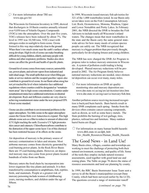
YOUR RIVER NEIGHBORHOOD ~ THE ROCK RIVER BASIN<br />
76<br />
For more information about TRI see:<br />
www.epa.gov/tri/<br />
The <strong>Wisconsin</strong> Air Emission Inventory in 1999, showed<br />
that dischargers in 10 Basin counties annually released<br />
over 9,850 tons <strong>of</strong> Volatile Organic Compounds<br />
(VOCs) into the atmosphere. Over the past five years,<br />
VOCs releases have been reduced by about 7%. The<br />
level in 1995 was 10,540 tons. VOCs react with<br />
nitrogen oxides in sunlight to form ozone. Ozone<br />
formed in this way stays relatively close to the ground.<br />
When there’s too much ozone near the earth’s surface urbans<br />
smog develops. High levels <strong>of</strong> ozone can make breathing<br />
difficult for young children, elderly, and many people with<br />
asthma and other respiratory problems. Studies also show<br />
ozone can affect the growth and health <strong>of</strong> specific plants.<br />
Ground-level ozone comes from many sources; automobile<br />
use, power plants, and solvent vapors from industrial and<br />
individual usage. The small spills that occur when filling gas<br />
tanks at service stations and the escaped gasoline vapors also<br />
contribute to ground-level ozone. In our Basin urban smog has<br />
not yet reached the level where industries face additional<br />
regulations where counties could be designated as “nonattainment<br />
areas” due to high ozone concentrations. Counties under<br />
nonattainment status have additional restrictions on idustrial<br />
developemnt. Rock and Jefferson counties are very close to<br />
achieving nonattainment status under the new proposed EPA<br />
8-hour ozone standard.<br />
Ozone can also contribute to environmental problems in the<br />
upper atmosphere. Too little ozone in the upper atmosphere<br />
causes the Ozone Hole over Antacrctica to expand. This high<br />
altitude ozone acts as a filter to reduce to amount <strong>of</strong> ultraviolet<br />
(UV) light reaching the earth. Excessive UV light promotes<br />
skin cancer and cataracts. Chlor<strong>of</strong>luorocarbons contribute to<br />
the distruction <strong>of</strong> the upper ozone layer. Use <strong>of</strong> this chemical<br />
has been restricted because <strong>of</strong> its effects on the ozone.<br />
Air deposition <strong>of</strong> mercury is the primary source <strong>of</strong><br />
mercury contamination in lakes and streams. Most<br />
airborne mercury comes from electricity generated by<br />
coal-burning power plants. In the Rock River Basin<br />
there are 19 coal-burning plants. However, air deposited<br />
mercury may also come from power plants located<br />
hundreds <strong>of</strong> miles from our Basin.<br />
Mercury enters the food chain by incorporation into<br />
lower organism like tiny plants and animals. It is then<br />
transferred by consumption to amphibians, fish, reptiles.<br />
birds, and mammals. People at a greatest risk <strong>of</strong><br />
mercury poisoning include women <strong>of</strong> childbearing<br />
years, nursing mothers, and children under the age <strong>of</strong><br />
fifteen.<br />
In 1999, <strong>Wisconsin</strong> issued mercury fish advisories for<br />
321 <strong>of</strong> the 1,000 waterbodies tested. In our Basin only<br />
seven lakes were on the Fish Consumption Advisory<br />
List: Rock, Oconomowoc, Monona, Waubesa, Upper<br />
and Lower Nemahbin and Pretty Lakes. In February<br />
2001, the NRB directed the DNR to broaden the Fish<br />
Advisory to include nearly all <strong>Wisconsin</strong>’s inland<br />
waters. The changes mean that most waterbodies in<br />
the state and the Basin carry the same general statewide<br />
advice for how many meals <strong>of</strong> certain species<br />
people can safely eat. The NRB recognized that<br />
mercury is a bigger problem than previously thought,<br />
particularly for developing fetuses and young children.<br />
The NRB has now charged the DNR Air Program to<br />
propose rules to reduce mercury emissions in <strong>Wisconsin</strong>.<br />
A system <strong>of</strong> pollution credit trading is being<br />
developed. Phased mercury reductions will be proposed<br />
in 2002. The Air Program firmly believes<br />
national mercury reductions are needed, since elemental<br />
deposition can occur over many, many miles.<br />
For more information on DNR air quality<br />
monitoring sites and mercury deposition see:<br />
www.dnr.state.wi.us/org/aw/air/monitor/sites.htm<br />
www.dnr.state.wi.us/org/caer/ce/mercury/fish.htm<br />
Another pollution source receiving increased recognition<br />
is backyard burn barrels. Burn barrels result in<br />
many DNR complaints each spring. Smoke from the<br />
devices <strong>of</strong>ten contains cancer-causing compounds,<br />
such as dioxin, as well as some heavy metals. The<br />
State prohibits the burning <strong>of</strong> wet garbage, tires,<br />
plastics, railroad ties and furniture. Many outdoor<br />
barrel burns are illegal.<br />
For information on many human health hazards:<br />
www.dhfs.state.wi.us/dph_beh/<br />
Env_Health_<strong>Resources</strong>/Human_Health_Hazards<br />
The Good News - in Land Use!<br />
Many Basin cities, villages, counties and townships are<br />
working to meet the challenge <strong>of</strong> protecting both their<br />
natural environment, economy, and quality <strong>of</strong> life. Some<br />
<strong>of</strong> the tools they employ include natural resource<br />
assessments, used together with good land use and<br />
zoning plans. The Table on page 78 shows the status <strong>of</strong><br />
resource assessments and land use planning by county.<br />
In 1999, the RRC Basin Stormwater Issue Team sent a<br />
survey to all the Basin’s municipalities (except Dane<br />
County, which had been surveyed earlier by the LCD).<br />
The questions covered a range <strong>of</strong> stormwater run<strong>of</strong>f<br />
(continued on page 79)
![Nature program winter schedule [PDF] - Wisconsin DNR](https://img.yumpu.com/22471254/1/190x245/nature-program-winter-schedule-pdf-wisconsin-dnr.jpg?quality=85)
![City of Middleton [PDF] - Wisconsin Department of Natural Resources](https://img.yumpu.com/22300392/1/190x245/city-of-middleton-pdf-wisconsin-department-of-natural-resources.jpg?quality=85)
![Wetland Conservation Activities [PDF] - Wisconsin Department of ...](https://img.yumpu.com/21975633/1/190x245/wetland-conservation-activities-pdf-wisconsin-department-of-.jpg?quality=85)
![Baraboo River Region[PDF] - Wisconsin Department of Natural ...](https://img.yumpu.com/21975619/1/190x245/baraboo-river-regionpdf-wisconsin-department-of-natural-.jpg?quality=85)