Lower Baraboo River - Wisconsin Department of Natural Resources
Lower Baraboo River - Wisconsin Department of Natural Resources
Lower Baraboo River - Wisconsin Department of Natural Resources

Create successful ePaper yourself
Turn your PDF publications into a flip-book with our unique Google optimized e-Paper software.
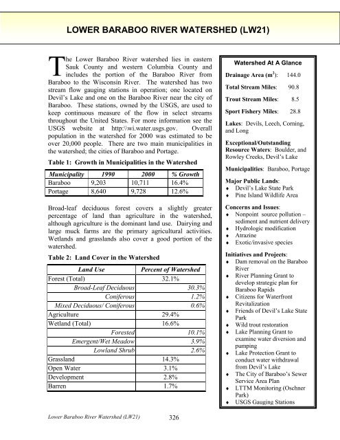
LOWER BARABOO RIVER WATERSHED (LW21)<br />
The <strong>Lower</strong> <strong>Baraboo</strong> <strong>River</strong> watershed lies in eastern<br />
Sauk County and western Columbia County and<br />
includes the portion <strong>of</strong> the <strong>Baraboo</strong> <strong>River</strong> from<br />
<strong>Baraboo</strong> to the <strong>Wisconsin</strong> <strong>River</strong>. The watershed has two<br />
stream flow gauging stations in operation; one located on<br />
Devil’s Lake and one on the <strong>Baraboo</strong> <strong>River</strong> near the city <strong>of</strong><br />
<strong>Baraboo</strong>. These stations, owned by the USGS, are used to<br />
keep continuous measure <strong>of</strong> the flow in select streams<br />
throughout the United States. For more information see the<br />
USGS website at http:\\wi.water.usgs.gov. Overall<br />
population in the watershed for 2000 was estimated to be<br />
over 20,000 people. There are two main municipalities in<br />
the watershed; the cities <strong>of</strong> <strong>Baraboo</strong> and Portage.<br />
Table 1: Growth in Municipalities in the Watershed<br />
Municipality 1990 2000 % Growth<br />
<strong>Baraboo</strong> 9,203 10,711 16.4%<br />
Portage 8,640 9,728 12.6%<br />
Broad-leaf deciduous forest covers a slightly greater<br />
percentage <strong>of</strong> land than agriculture in the watershed,<br />
although agriculture is the dominant land use. Dairying and<br />
large muck farms are the primary agricultural activities.<br />
Wetlands and grasslands also cover a good portion <strong>of</strong> the<br />
watershed.<br />
Table 2: Land Cover in the Watershed<br />
Land Use<br />
Percent <strong>of</strong> Watershed<br />
Forest (Total) 32.1%<br />
Broad-Leaf Deciduous 30.3%<br />
Coniferous 1.2%<br />
Mixed Deciduous/ Coniferous 0.6%<br />
Agriculture 29.4%<br />
Wetland (Total) 16.6%<br />
Forested 10.1%<br />
Emergent/Wet Meadow 3.9%<br />
Lowland Shrub 2.6%<br />
Grassland 14.3%<br />
Open Water 3.1%<br />
Development 2.8%<br />
Barren 1.7%<br />
Watershed At A Glance<br />
Drainage Area (m 2 ): 144.0<br />
Total Stream Miles: 90.8<br />
Trout Stream Miles: 8.5<br />
Sport Fishery Miles: 28.8<br />
Lakes: Devils, Leech, Corning,<br />
and Long<br />
Exceptional/Outstanding<br />
Resource Waters: Boulder, and<br />
Rowley Creeks, Devil’s Lake<br />
Municipalities: <strong>Baraboo</strong>, Portage<br />
Major Public Lands:<br />
♦ Devil’s Lake State Park<br />
♦ Pine Island Wildlife Area<br />
Concerns and Issues:<br />
♦ Nonpoint source pollution –<br />
sediment and nutrient delivery<br />
♦ Hydrologic modification<br />
♦ Atrazine<br />
♦ Exotic/invasive species<br />
Initiatives and Projects:<br />
♦ Dam removal on the <strong>Baraboo</strong><br />
<strong>River</strong><br />
♦ <strong>River</strong> Planning Grant to<br />
develop strategic plan for<br />
<strong>Baraboo</strong> Rapids<br />
♦ Citizens for Waterfront<br />
Revitalization<br />
♦ Friends <strong>of</strong> Devil’s Lake State<br />
Park<br />
♦ Wild trout restoration<br />
♦ Lake Planning Grant to<br />
examine water diversion and<br />
pumping<br />
♦ Lake Protection Grant to<br />
conduct water withdrawal<br />
from Devil’s Lake<br />
♦ The City <strong>of</strong> <strong>Baraboo</strong>’s Sewer<br />
Service Area Plan<br />
♦ LTTM Monitoring (Oschner<br />
Park)<br />
♦ USGS Gauging Stations<br />
<strong>Lower</strong> <strong>Baraboo</strong> <strong>River</strong> Watershed (LW21) 326
Dams have historically been a major impairment in the watershed. The impoundments<br />
created by these dams increased siltation behind the structures and warmed the water. In<br />
addition, these dams were an obstacle to fish migration. These dams, however, have since<br />
been removed. With the removal <strong>of</strong> the final dam, the Linen Mill Dam, in October <strong>of</strong> 2001,<br />
the <strong>Baraboo</strong> <strong>River</strong> is now the longest mainstream stretch <strong>of</strong> restored river in the country.<br />
Other issues that affect resources in the watershed include nonpoint sources <strong>of</strong> pollution,<br />
atrazine contamination <strong>of</strong> groundwater sources, hydrologic modification <strong>of</strong> streams and exotic<br />
and invasive species. An atrazine prohibition area is located in the area bordered to the north<br />
by the <strong>Baraboo</strong> <strong>River</strong>, to the west by Intestates 90/94 and to the east and south by the<br />
<strong>Wisconsin</strong> <strong>River</strong>. See Appendix B.<br />
The ditching and draining <strong>of</strong> wetlands to create muck farms has had a significant impact on<br />
the habitat and water quality <strong>of</strong> surface waters. These farms not only modify the hydrologic<br />
regime in a stream, but they contribute large volumes <strong>of</strong> nutrients and sediments to streams.<br />
The watershed is not ranked with respect to nonpoint source pollution priorities. The exotic<br />
and invasive garlic mustard plant is also causing some problems at Devil’s Lake State Park<br />
and in the <strong>Baraboo</strong> Bluffs. Garlic mustard is a threat to woodland areas because <strong>of</strong> its ability<br />
to displace native vegetation and can shade out tree and shrub seedlings. Another exotic,<br />
Eurasian water milfoil, has been found and is known to cause problems on the lake.<br />
In the watershed, the cities <strong>of</strong> <strong>Baraboo</strong> and Portage discharge to the <strong>Baraboo</strong> <strong>River</strong> and the<br />
<strong>Wisconsin</strong> <strong>River</strong>, respectively. Other point source discharge permittees are the Ho-Chunk<br />
Nations and J&L Oil, both <strong>of</strong> which discharge to groundwater. Teel Plastics is the only<br />
industrial discharges in the watershed and discharges to the <strong>Baraboo</strong> <strong>River</strong>.<br />
The <strong>Lower</strong> <strong>Baraboo</strong> <strong>River</strong> Watershed has a variety <strong>of</strong> good quality habitats and rare plant<br />
communities that are listed on the state’s <strong>Natural</strong> Heritage Inventory, (NHI), kept by the<br />
Bureau <strong>of</strong> Endangered <strong>Resources</strong>. Of particular interest in the watershed is the north slope <strong>of</strong><br />
the <strong>Baraboo</strong> Range, a Precambrian inlier set <strong>of</strong> hills. These hills are heavily wooded and have<br />
unique sub-ecosystems containing rare plant species. These hills have been selected as an<br />
area <strong>of</strong> significance by the Land Legacy Study, see page 63. Other interesting communities<br />
are:<br />
♦ Cedar glade ♦ Calcareous fen<br />
♦ Dry cliff ♦ Emergent aquatic<br />
♦ Dry prairie ♦ Floodplain forest<br />
♦ Glaciere talus ♦ Forested seep<br />
♦ Mesic prairie ♦ Oxbow lake<br />
♦ Moist cliff ♦ Lake—shallow, s<strong>of</strong>t, seepage<br />
♦ Northern dry forest ♦ Northern wet forest<br />
♦ Northern dry-mesic forest ♦ Shrub-carr<br />
♦ Oak opening ♦ Southern sedge meadow<br />
♦ Pine relict ♦ Springs and spring runs, s<strong>of</strong>t<br />
♦ Sand meadow ♦ Stream—fast, hard, cold<br />
♦ Southern dry forest ♦ Stream—fast, s<strong>of</strong>t, cold<br />
♦ Southern dry-mesic forest ♦ Stream—fast, s<strong>of</strong>t, warm<br />
♦ Southern mesic forest ♦ Stream—slow, s<strong>of</strong>t, warm<br />
♦ Alder thicket ♦ Wet prairie<br />
<strong>Lower</strong> <strong>Baraboo</strong> <strong>River</strong> Watershed (LW21) 327
In addition to these special communities, the watershed is also home for a variety <strong>of</strong> rare plant<br />
and animal species including; 10 species <strong>of</strong> birds, 7 species <strong>of</strong> butterflies, 5 species <strong>of</strong><br />
dragonflies, 7 species <strong>of</strong> fish, 2 species <strong>of</strong> mayflies, 6 species <strong>of</strong> mussels, 42 plant species, 2<br />
species <strong>of</strong> snakes, 1 species <strong>of</strong> turtle, 4 species <strong>of</strong> mammals, 1 species <strong>of</strong> lizard and 1 species<br />
<strong>of</strong> snail. These plants and animals are also listed on the state’s <strong>Natural</strong> Heritage Inventory<br />
(NHI).<br />
The 5,043-acre Pine Island Wildlife Area is in the watershed and <strong>of</strong>fers opportunities for<br />
canoeing and boating on the <strong>Wisconsin</strong> <strong>River</strong> in addition to dog training, hiking, and fishing.<br />
Devil’s Lake State Park is also in the watershed.<br />
RIVERS AND STREAMS IN THE WATERSHED<br />
<strong>Baraboo</strong> <strong>River</strong><br />
The <strong>Baraboo</strong> <strong>River</strong> is a warm water sport fishery and canoe trail that is tributary to the<br />
<strong>Wisconsin</strong> <strong>River</strong>. The <strong>Baraboo</strong> <strong>River</strong> has historically had up to seven dams at one time along<br />
its entire length. Most <strong>of</strong> these dams were built to generate water power, although in the past<br />
years, they have been maintained mostly for recreational purposes. As a result <strong>of</strong> the habitat<br />
fragmentation and other problems caused by the dams on the river, the two miles <strong>of</strong> the river<br />
that flows through the City <strong>of</strong> <strong>Baraboo</strong> has been listed on the state’s list <strong>of</strong> impaired water.<br />
In the past few years, there has been a strong movement to remove these dams from the river<br />
and once again open the channel up for free migration by fish, open navigation for<br />
recreational purposes, and re-establishment <strong>of</strong> the free-flowing river. The City <strong>of</strong> <strong>Baraboo</strong> in<br />
the <strong>Lower</strong> <strong>Baraboo</strong> <strong>River</strong> Watershed was the home <strong>of</strong> three <strong>of</strong> these dams. All three dams<br />
have now been removed. Prior to the removal <strong>of</strong> the third dam in October 2001, the removal<br />
<strong>of</strong> the other two opened up 5 miles <strong>of</strong> rock riffles, which had a three-fold effect:<br />
1. Increased spawning area for walleye, sturgeon, suckers (and paddlefish if they can get<br />
around Prairie du Sac dam);<br />
2. Creation <strong>of</strong> a “food factory” for the fish on the rock riffle area;<br />
3. Opening up <strong>of</strong> natural, seasonal movement throughout the <strong>Baraboo</strong> <strong>River</strong> system.<br />
It is the hope <strong>of</strong> all <strong>of</strong> the partners involved that even greater effects will be seen in the river<br />
as a result <strong>of</strong> the restoration <strong>of</strong> the river to its free-flowing condition. Monitoring will be<br />
conducted to determine the overall impact <strong>of</strong> the removal <strong>of</strong> the dams on the river. A rare<br />
aquatic species has been found in the river in past surveys. As a result <strong>of</strong> the dam removals,<br />
the process has begun to take this segment <strong>of</strong> the river <strong>of</strong>f <strong>of</strong> the list <strong>of</strong> impaired water list.<br />
The Citizens for Waterfront Revitalization have received a <strong>River</strong> Planning Grant to develop a<br />
cooperative strategic plan for the <strong>Baraboo</strong> Rapids area <strong>of</strong> the river. This area is from the<br />
Highway 12 bridge in West <strong>Baraboo</strong> to the Highway 113 bridge east <strong>of</strong> the city. The plan<br />
will address some <strong>of</strong> the watershed-wide issues that affect the river. There is a USGS gauging<br />
station near <strong>Baraboo</strong>.<br />
<strong>Lower</strong> <strong>Baraboo</strong> <strong>River</strong> Watershed (LW21) 328
Boulder Creek<br />
Boulder Creek is a Class I trout stream and an exceptional resource water (ERW). The small<br />
creek is a tributary to the <strong>Baraboo</strong> <strong>River</strong> and supports some natural reproduction <strong>of</strong> brook<br />
trout. The creek is impacted by streambank pasturing in the middle and upper portions.<br />
Baseline surveys conducted in the summer <strong>of</strong> 2000 rated the health <strong>of</strong> the warm water fishery<br />
to be fair and the health <strong>of</strong> the cold water fishery to be good.<br />
Leech Creek<br />
Leech Creek is a tributary to the <strong>Baraboo</strong> <strong>River</strong>. Just over 2.5 miles are classified as a Class<br />
II trout stream and the stream supports some natural reproduction <strong>of</strong> both brook and brown<br />
trout. The lower half <strong>of</strong> the stream could possibly have trout stream potential, but has been<br />
extensively ditched and straightened. There is a muck farm on a portion <strong>of</strong> the creek that is a<br />
source <strong>of</strong> sediments and nutrients. There are currently no plans to remove the farm. Surveys<br />
<strong>of</strong> the warm water fish communities have found it to be in fair condition.<br />
Rowley Creek<br />
Rowley Creek begins in Columbia County. The creek has a good gradient from the Sauk<br />
County line to the <strong>Baraboo</strong> <strong>River</strong>. The creek has an excellent brook and brown trout fishery<br />
and the lower 2.7 miles <strong>of</strong> Rowley Creek are considered a Class I trout stream and an<br />
exceptional resource water (ERW). The 2 miles upstream <strong>of</strong> this are Class II trout waters and<br />
also an ERW. Baseline surveys conducted in the summer <strong>of</strong> 2000 found the warm water and<br />
cold water fisheries to be in good health.<br />
<strong>Wisconsin</strong> <strong>River</strong><br />
A portion <strong>of</strong> the <strong>Wisconsin</strong> <strong>River</strong> flows through this watershed. For more information on the<br />
<strong>Wisconsin</strong> <strong>River</strong>, see page 90.<br />
LAKE IN THE WATERSHED<br />
Devils Lake<br />
Devils Lake is a seepage lake in Devils Lake State Park. The lake is a popular recreation area<br />
and has a diverse sport fishery. The lake can support a two-story brown trout fishery. Six feet<br />
below the thermocline, the water still has enough oxygen to support a population <strong>of</strong> brown<br />
trout. Devils Lake is oligotrophic and usually has excellent water clarity. The lake is<br />
designated an outstanding resource water (ORW).<br />
Problems in the lake are due to high levels <strong>of</strong> phosphorus, the prevalence <strong>of</strong> an invasive exotic<br />
plant species, and the presence <strong>of</strong> mercury in the water column. A fish consumption advisory<br />
exists on the lake for walleye due to the levels <strong>of</strong> mercury found in the fish’s tissue samples.<br />
The sources <strong>of</strong> the mercury are unknown, but may be naturally occurring or come from<br />
airborne deposition. Core sampling <strong>of</strong> bottom sediments in 1987 yielded little conclusive<br />
information. In addition, beds <strong>of</strong> Eurasian milfoil, an undesirable exotic plant species, have<br />
become problematic on the lake. High levels <strong>of</strong> phosphorus have also been attributed to this<br />
and other problems in the lake’s ecosystem. One <strong>of</strong> these other problems is the presence <strong>of</strong><br />
the parasite that causes swimmer’s itch. It is suspected that this parasite lives on snails that<br />
feed on the algae that grows in the lake because <strong>of</strong> the phosphorus.<br />
<strong>Lower</strong> <strong>Baraboo</strong> <strong>River</strong> Watershed (LW21) 329
Starting in 2002 and running for 10 – 15 years, the <strong>Department</strong> will be conducting a bottom<br />
draw program every September through December to remove oxygen depleted water, which is<br />
the direct result <strong>of</strong> high phosphorus levels, from the bottom <strong>of</strong> the lake through a<br />
hypolimnetic withdrawal. This project will hopefully do 5 main things:<br />
1. Decrease periphyton growth on rocks<br />
2. Decrease filamentous algae growth in lake shallows<br />
3. Decrease snails that feed on these algae and therefore, decrease the number <strong>of</strong> hosts<br />
for the parasite that causes Swimmer’s Itch.<br />
4. Improve aquatic habitat for the lake’s brown trout population that is currently in<br />
danger as a result <strong>of</strong> the low oxygen levels<br />
5. Decrease the amount <strong>of</strong> time that mercury in bottom sediments can methalize and<br />
bioaccumulate in aquatic species.<br />
Since the lake is fed mostly by groundwater seeps and through precipitation, this withdrawal<br />
<strong>of</strong> water does have the potential to lower the lakes level. This problems has been addressed<br />
and it is planned to re-charge the lake through the re-connection <strong>of</strong> a previously diverted<br />
stream. This project is funded through a Lake Planning and a Lake Protection Grant. There is<br />
a USGS gauging station on Devil’s Lake.<br />
Long Lake<br />
Long Lake is a fairly shallow lake located in Columbia County. It is a meander lake <strong>of</strong> the<br />
<strong>Wisconsin</strong> <strong>River</strong> and although the lake is normally landlocked, it does receive floodwaters<br />
from the river. The fishery in the lake is comprised mainly <strong>of</strong> panfish, although some river<br />
species can occasionally be found as a result <strong>of</strong> this flooding.<br />
Silver Lake<br />
This lake is located on the terminal moraine in Portage. The landlocked lake is approximately<br />
74 acres. The lake experiences some problems as a result <strong>of</strong> weed growth and stunted panfish<br />
populations. The fishery in the lake is largemouth bass, panfish and northern pike.<br />
RECOMMENDATIONS (LW21)<br />
♦<br />
♦<br />
♦<br />
♦<br />
♦<br />
An investigation should be conducted to determine a way, other than through the use <strong>of</strong><br />
chemicals or machines, to reduce undesirable aquatic plant beds, such as Eurasian water<br />
milfoil, in Devils Lake.<br />
Additional lake bottom sediment monitoring in Devils Lake should be completed to<br />
determine if elevated levels <strong>of</strong> mercury or other toxic substances exist.<br />
Baseline monitoring on Leech Creek should be conducted.<br />
The fish in Devil's Lake and the <strong>Baraboo</strong> <strong>River</strong> above and below the city <strong>of</strong> <strong>Baraboo</strong><br />
should be monitored to determine the presence <strong>of</strong> toxic substances.<br />
Leech Creek should be re-meandered to establish a healthy trout stream.<br />
<strong>Lower</strong> <strong>Baraboo</strong> <strong>River</strong> Watershed (LW21) 330
♦<br />
♦<br />
♦<br />
♦<br />
Public funding from the state and from federal 314 money should be sought to fund lake<br />
protection programs that focus on decreasing the input <strong>of</strong> nutrients to lakes, such as<br />
Devil’s Lake.<br />
The <strong>Baraboo</strong> <strong>River</strong> should be surveyed to determine if rare aquatic elements previously<br />
found in the river is still present.<br />
Improve northern pike spawning habitat near the mouth <strong>of</strong> the <strong>Baraboo</strong> <strong>River</strong>.<br />
Opportunities for canoeing on the <strong>Baraboo</strong> <strong>River</strong> should be improved.<br />
<strong>Lower</strong> <strong>Baraboo</strong> <strong>River</strong> Watershed (LW21) 331
Watershed map<br />
<strong>Lower</strong> <strong>Baraboo</strong> <strong>River</strong> Watershed (LW21) 332
Streams in the <strong>Lower</strong> <strong>Baraboo</strong> <strong>River</strong> Watershed (LW21) Sauk and Columbia Counties Area: 144 sq miles<br />
Stream Name WBIC<br />
Length<br />
(miles)<br />
Existing<br />
Use<br />
Potential<br />
Use<br />
Supporting<br />
Potential Use<br />
Codified Use and<br />
Trout Stream<br />
Classification<br />
Proposed<br />
Codified Use<br />
303(d)<br />
Status<br />
Rare<br />
Aquatic<br />
Species<br />
Use Impairment<br />
Source Impact<br />
NPS<br />
Rank<br />
Monitored/<br />
Evaluated/<br />
Unassessed<br />
Data<br />
Level<br />
Trend Ref.*<br />
<strong>Baraboo</strong> <strong>River</strong> 1271100 28.8 WWSF same Part WWSF same Y/2 Y<br />
NPS, PSM,<br />
PSI, SB, HM<br />
HAB M M B2 U<br />
4, 5, 15,<br />
16, 19<br />
Boulder Creek 1273200 0-1.2 COLD I same Full COLD I/ERW same N N PSB HAB M M (2000) B4, H1 U 5, 19<br />
1.2-3 COLD same Part ERW same N U<br />
Leech Creek 1271600 0-4.7 WWFF COLD II Not DEF same N N HM HAB H M B2 U<br />
4, 5, 15,<br />
19<br />
4.7-7.3 COLD II same Part COLD II same N PSB, BDAM HAB U<br />
Rowley Creek 1272100 0-2.7 COLD I same Full COLD I/ERW same N N NPS, BDAM HAB M M (2000) B4, H1 U 5, 15, 19<br />
2.7-4.7 COLD II same Part DEF/ERW COLD II N U<br />
4.7-8 WWFF same Part DEF/ERW same N U<br />
Unnamed streams 43.7 DEF<br />
Total Stream Miles 90.8<br />
COLD 1.8<br />
COLD I 3.9<br />
COLD II 4.6<br />
WWSF 28.8<br />
WWFF 12.7<br />
U 43.7<br />
*The numbers in this column refer to the References found in the corresponding Watershed Narrative.<br />
See Appendix J: "How to Read the Stream Tables," in Chapter 7 <strong>of</strong> the State <strong>of</strong> the <strong>Lower</strong> <strong>Wisconsin</strong> <strong>River</strong> Basin Report.<br />
<strong>Lower</strong> <strong>Baraboo</strong> <strong>River</strong> Watershed (LW21) 333
Lakes in the <strong>Lower</strong> <strong>Baraboo</strong> <strong>River</strong> Watershed (LW21) Sauk and Columbia Counties<br />
Lake Name WBIC County<br />
Surface<br />
Area<br />
(Acres)<br />
Max<br />
Depth<br />
Lake<br />
Type<br />
Winterkill Access SH Hg MAC LMO TSI<br />
Lake Plan or<br />
Prot<br />
P Sens Comments<br />
Corning Lake 1294900 Columbia 27 4 SE NW 2<br />
Devils Lake 980900 Sauk 369 47 SE N BR C M EWM 31 PROT/ PLAN 1<br />
lakes planning grant<br />
proj.<br />
Long Lake 1000700 Columbia 69 20 SE N BR 2<br />
See Appendix K: "How to Read the Lake Tables," in Chapter 7 <strong>of</strong> the <strong>Lower</strong> <strong>Wisconsin</strong> State <strong>of</strong> the Basin Report.<br />
<strong>Lower</strong> <strong>Baraboo</strong> <strong>River</strong> Watershed (LW21) 334
REFERENCES<br />
1. Ball, Joseph R. , Tom Smith, C.W. Threinen. Surface Water <strong>Resources</strong> <strong>of</strong> Sauk County.<br />
<strong>Department</strong> <strong>of</strong> <strong>Natural</strong> <strong>Resources</strong>. 1971.<br />
2. Enterprise Information, Technology and Applications, Bureau <strong>of</strong>. <strong>Wisconsin</strong> DNR. The<br />
WISCLAND Land Cover Data. Data from 1991 to 1993. Published in 1998.<br />
3. Enterprise Information, Technology and Applications, Bureau <strong>of</strong>. <strong>Wisconsin</strong> DNR.<br />
User’s Guide to WISCLAND Land Cover Data. 1998.<br />
4. Fix, Steve. <strong>Lower</strong> <strong>Wisconsin</strong> <strong>River</strong> Basin Water Quality Management Plan. <strong>Wisconsin</strong><br />
<strong>Department</strong> <strong>of</strong> <strong>Natural</strong> <strong>Resources</strong>. PUBL-WR-001-94-REV. 1994.<br />
5. Larson, Tim. Personal Communications. <strong>Wisconsin</strong> <strong>Department</strong> <strong>of</strong> <strong>Natural</strong> <strong>Resources</strong>.<br />
2000 - 2001.<br />
6. Marshall, Dave. Personal Communications. <strong>Wisconsin</strong> <strong>Department</strong> <strong>of</strong> <strong>Natural</strong><br />
<strong>Resources</strong>. 2000 - 2001.<br />
7. Morton, Andy. <strong>Baraboo</strong> <strong>River</strong> Dam Removal and Restoration Project. Unpublished.<br />
<strong>Wisconsin</strong> <strong>Department</strong> <strong>of</strong> <strong>Natural</strong> <strong>Resources</strong>. 2000.<br />
8. Morton, Andy. Personal Communications. <strong>Wisconsin</strong> <strong>Department</strong> <strong>of</strong> <strong>Natural</strong> <strong>Resources</strong>.<br />
2000 - 2001.<br />
9. North Central <strong>Wisconsin</strong> Regional Planning Commission. Watershed Population<br />
Estimates for the State <strong>of</strong> <strong>Wisconsin</strong>. May 2000.<br />
10. Osip<strong>of</strong>f, George. Personal Communications. <strong>Wisconsin</strong> <strong>Department</strong> <strong>of</strong> <strong>Natural</strong><br />
<strong>Resources</strong>. 2000.<br />
11. P<strong>of</strong>f, Ronald and C.W. Threinen. Surface Water <strong>Resources</strong> <strong>of</strong> Columbia County.<br />
<strong>Wisconsin</strong> <strong>Department</strong> <strong>of</strong> <strong>Natural</strong> <strong>Resources</strong>. 1965.<br />
12. United States Geological Survey. Water <strong>Resources</strong> <strong>of</strong> <strong>Wisconsin</strong> Website.<br />
http:\\wi.water.usgs.gov.<br />
13. <strong>Wisconsin</strong> <strong>Department</strong> <strong>of</strong> Administration. Population Projections and Census 2000<br />
websites, Http://www.doa.state.wi.us/dhir/boir/demographic/pop_proj.asp. Last updated<br />
August 2000.<br />
14. <strong>Wisconsin</strong> <strong>Department</strong> <strong>of</strong> Agriculture, Trade and Consumer Protection (WDATCP).<br />
Atrazine Prohibition Web site, http://datcp.state.wi.us/arm/agriculture/pest-fert/atrazine/<br />
and ATCP 30, <strong>Wisconsin</strong> Administrative Code. 2001.<br />
15. <strong>Wisconsin</strong> <strong>Department</strong> <strong>of</strong> <strong>Natural</strong> <strong>Resources</strong>. Fish Management Files, Southcentral<br />
Region. Through 2000.<br />
16. <strong>Wisconsin</strong> <strong>Department</strong> <strong>of</strong> <strong>Natural</strong> <strong>Resources</strong>. Water <strong>Resources</strong> Management Files –<br />
South Central Region. 2001.<br />
17. <strong>Wisconsin</strong> DNR. <strong>Wisconsin</strong> DNR’s Public Wildlife Recreation Land. PUBL-WM-001-<br />
98. 1998.<br />
18. <strong>Wisconsin</strong> DNR. <strong>Wisconsin</strong> Lakes. Bureau <strong>of</strong> Water <strong>Resources</strong> Management and Bureau<br />
<strong>of</strong> Fisheries Management. 1995.<br />
19. <strong>Wisconsin</strong> <strong>Department</strong> <strong>of</strong> <strong>Natural</strong> <strong>Resources</strong>. Fisheries Management, Bureau <strong>of</strong>.<br />
<strong>Wisconsin</strong> Trout Streams. 1980.<br />
<strong>Lower</strong> <strong>Baraboo</strong> <strong>River</strong> Watershed (LW21) 335
![Nature program winter schedule [PDF] - Wisconsin DNR](https://img.yumpu.com/22471254/1/190x245/nature-program-winter-schedule-pdf-wisconsin-dnr.jpg?quality=85)
![City of Middleton [PDF] - Wisconsin Department of Natural Resources](https://img.yumpu.com/22300392/1/190x245/city-of-middleton-pdf-wisconsin-department-of-natural-resources.jpg?quality=85)
![Wetland Conservation Activities [PDF] - Wisconsin Department of ...](https://img.yumpu.com/21975633/1/190x245/wetland-conservation-activities-pdf-wisconsin-department-of-.jpg?quality=85)
![Baraboo River Region[PDF] - Wisconsin Department of Natural ...](https://img.yumpu.com/21975619/1/190x245/baraboo-river-regionpdf-wisconsin-department-of-natural-.jpg?quality=85)