carroll county department of public works - Carroll County Government
carroll county department of public works - Carroll County Government
carroll county department of public works - Carroll County Government

Create successful ePaper yourself
Turn your PDF publications into a flip-book with our unique Google optimized e-Paper software.
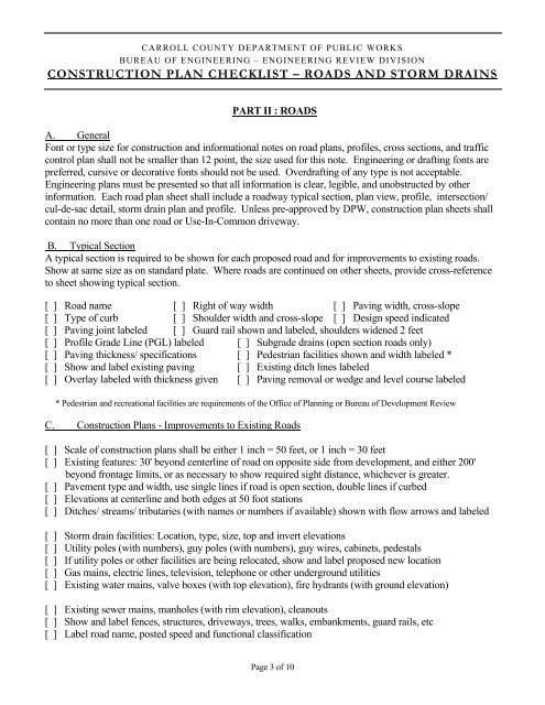
CARROLL COUNTY DEPARTMENT OF PUBLIC WORKS<br />
BUREAU OF ENGINEERING – ENGINEERING REVIEW DIVISION<br />
CONSTRUCTION PLAN CHECKLIST – ROADS AND STORM DRAINS<br />
PART II : ROADS<br />
A. General<br />
Font or type size for construction and informational notes on road plans, pr<strong>of</strong>iles, cross sections, and traffic<br />
control plan shall not be smaller than 12 point, the size used for this note. Engineering or drafting fonts are<br />
preferred, cursive or decorative fonts should not be used. Overdrafting <strong>of</strong> any type is not acceptable.<br />
Engineering plans must be presented so that all information is clear, legible, and unobstructed by other<br />
information. Each road plan sheet shall include a roadway typical section, plan view, pr<strong>of</strong>ile, intersection/<br />
cul-de-sac detail, storm drain plan and pr<strong>of</strong>ile. Unless pre-approved by DPW, construction plan sheets shall<br />
contain no more than one road or Use-In-Common driveway.<br />
B. Typical Section<br />
A typical section is required to be shown for each proposed road and for improvements to existing roads.<br />
Show at same size as on standard plate. Where roads are continued on other sheets, provide cross-reference<br />
to sheet showing typical section.<br />
[ ] Road name [ ] Right <strong>of</strong> way width [ ] Paving width, cross-slope<br />
[ ] Type <strong>of</strong> curb [ ] Shoulder width and cross-slope [ ] Design speed indicated<br />
[ ] Paving joint labeled [ ] Guard rail shown and labeled, shoulders widened 2 feet<br />
[ ] Pr<strong>of</strong>ile Grade Line (PGL) labeled [ ] Subgrade drains (open section roads only)<br />
[ ] Paving thickness/ specifications [ ] Pedestrian facilities shown and width labeled *<br />
[ ] Show and label existing paving [ ] Existing ditch lines labeled<br />
[ ] Overlay labeled with thickness given [ ] Paving removal or wedge and level course labeled<br />
* Pedestrian and recreational facilities are requirements <strong>of</strong> the Office <strong>of</strong> Planning or Bureau <strong>of</strong> Development Review<br />
C. Construction Plans - Improvements to Existing Roads<br />
[ ] Scale <strong>of</strong> construction plans shall be either 1 inch = 50 feet, or 1 inch = 30 feet<br />
[ ] Existing features: 30' beyond centerline <strong>of</strong> road on opposite side from development, and either 200'<br />
beyond frontage limits, or as necessary to show required sight distance, whichever is greater.<br />
[ ] Pavement type and width, use single lines if road is open section, double lines if curbed<br />
[ ] Elevations at centerline and both edges at 50 foot stations<br />
[ ] Ditches/ streams/ tributaries (with names or numbers if available) shown with flow arrows and labeled<br />
[ ] Storm drain facilities: Location, type, size, top and invert elevations<br />
[ ] Utility poles (with numbers), guy poles (with numbers), guy wires, cabinets, pedestals<br />
[ ] If utility poles or other facilities are being relocated, show and label proposed new location<br />
[ ] Gas mains, electric lines, television, telephone or other underground utilities<br />
[ ] Existing water mains, valve boxes (with top elevation), fire hydrants (with ground elevation)<br />
[ ] Existing sewer mains, manholes (with rim elevation), cleanouts<br />
[ ] Show and label fences, structures, driveways, trees, walks, embankments, guard rails, etc<br />
[ ] Label road name, posted speed and functional classification<br />
Page 3 <strong>of</strong> 10