carroll county department of public works - Carroll County Government
carroll county department of public works - Carroll County Government
carroll county department of public works - Carroll County Government
You also want an ePaper? Increase the reach of your titles
YUMPU automatically turns print PDFs into web optimized ePapers that Google loves.
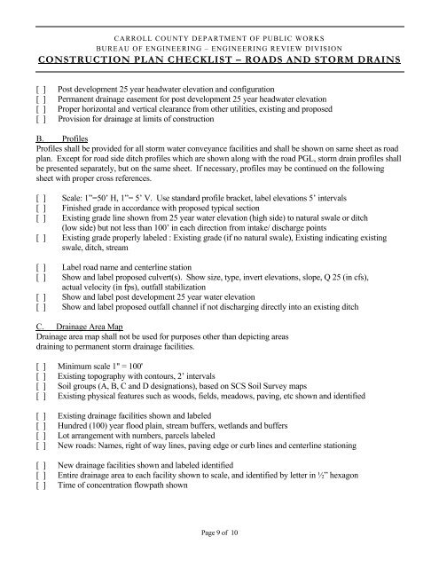
CARROLL COUNTY DEPARTMENT OF PUBLIC WORKS<br />
BUREAU OF ENGINEERING – ENGINEERING REVIEW DIVISION<br />
CONSTRUCTION PLAN CHECKLIST – ROADS AND STORM DRAINS<br />
[ ] Post development 25 year headwater elevation and configuration<br />
[ ] Permanent drainage easement for post development 25 year headwater elevation<br />
[ ] Proper horizontal and vertical clearance from other utilities, existing and proposed<br />
[ ] Provision for drainage at limits <strong>of</strong> construction<br />
B. Pr<strong>of</strong>iles<br />
Pr<strong>of</strong>iles shall be provided for all storm water conveyance facilities and shall be shown on same sheet as road<br />
plan. Except for road side ditch pr<strong>of</strong>iles which are shown along with the road PGL, storm drain pr<strong>of</strong>iles shall<br />
be presented separately, but on the same sheet. If necessary, pr<strong>of</strong>iles may be continued on the following<br />
sheet with proper cross references.<br />
[ ] Scale: 1”=50’ H, 1”= 5’ V. Use standard pr<strong>of</strong>ile bracket, label elevations 5’ intervals<br />
[ ] Finished grade in accordance with proposed typical section<br />
[ ] Existing grade line shown from 25 year water elevation (high side) to natural swale or ditch<br />
(low side) but not less than 100’ in each direction from intake/ discharge points<br />
[ ] Existing grade properly labeled : Existing grade (if no natural swale), Existing indicating existing<br />
swale, ditch, stream<br />
[ ] Label road name and centerline station<br />
[ ] Show and label proposed culvert(s). Show size, type, invert elevations, slope, Q 25 (in cfs),<br />
actual velocity (in fps), outfall stabilization<br />
[ ] Show and label post development 25 year water elevation<br />
[ ] Show and label proposed outfall channel if not discharging directly into an existing ditch<br />
C. Drainage Area Map<br />
Drainage area map shall not be used for purposes other than depicting areas<br />
draining to permanent storm drainage facilities.<br />
[ ] Minimum scale 1" = 100'<br />
[ ] Existing topography with contours, 2’ intervals<br />
[ ] Soil groups (A, B, C and D designations), based on SCS Soil Survey maps<br />
[ ] Existing physical features such as woods, fields, meadows, paving, etc shown and identified<br />
[ ] Existing drainage facilities shown and labeled<br />
[ ] Hundred (100) year flood plain, stream buffers, wetlands and buffers<br />
[ ] Lot arrangement with numbers, parcels labeled<br />
[ ] New roads: Names, right <strong>of</strong> way lines, paving edge or curb lines and centerline stationing<br />
[ ] New drainage facilities shown and labeled identified<br />
[ ] Entire drainage area to each facility shown to scale, and identified by letter in ½” hexagon<br />
[ ] Time <strong>of</strong> concentration flowpath shown<br />
Page 9 <strong>of</strong> 10


