List of Publications (pdf) - Florida Department of Environmental ...
List of Publications (pdf) - Florida Department of Environmental ...
List of Publications (pdf) - Florida Department of Environmental ...

You also want an ePaper? Increase the reach of your titles
YUMPU automatically turns print PDFs into web optimized ePapers that Google loves.
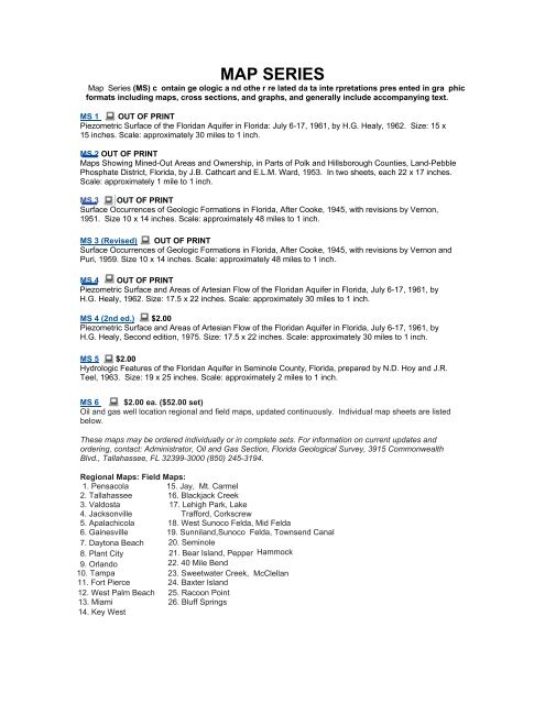
MAP SERIES<br />
Map Series (MS) c ontain ge ologic a nd othe r re lated da ta inte rpretations pres ented in gra phic<br />
formats including maps, cross sections, and graphs, and generally include accompanying text.<br />
MS 1 OUT OF PRINT<br />
Piezometric Surface <strong>of</strong> the <strong>Florida</strong>n Aquifer in <strong>Florida</strong>: July 6-17, 1961, by H.G. Healy, 1962. Size: 15 x<br />
15 inches. Scale: approximately 30 miles to 1 inch.<br />
MS 2 OUT OF PRINT<br />
Maps Showing Mined-Out Areas and Ownership, in Parts <strong>of</strong> Polk and Hillsborough Counties, Land-Pebble<br />
Phosphate District, <strong>Florida</strong>, by J.B. Cathcart and E.L.M. Ward, 1953. In two sheets, each 22 x 17 inches.<br />
Scale: approximately 1 mile to 1 inch.<br />
MS 3 OUT OF PRINT<br />
Surface Occurrences <strong>of</strong> Geologic Formations in <strong>Florida</strong>, After Cooke, 1945, with revisions by Vernon,<br />
1951. Size 10 x 14 inches. Scale: approximately 48 miles to 1 inch.<br />
MS 3 (Revised) OUT OF PRINT<br />
Surface Occurrences <strong>of</strong> Geologic Formations in <strong>Florida</strong>, After Cooke, 1945, with revisions by Vernon and<br />
Puri, 1959. Size 10 x 14 inches. Scale: approximately 48 miles to 1 inch.<br />
MS 4 OUT OF PRINT<br />
Piezometric Surface and Areas <strong>of</strong> Artesian Flow <strong>of</strong> the <strong>Florida</strong>n Aquifer in <strong>Florida</strong>, July 6-17, 1961, by<br />
H.G. Healy, 1962. Size: 17.5 x 22 inches. Scale: approximately 30 miles to 1 inch.<br />
MS 4 (2nd ed.) $2.00<br />
Piezometric Surface and Areas <strong>of</strong> Artesian Flow <strong>of</strong> the <strong>Florida</strong>n Aquifer in <strong>Florida</strong>, July 6-17, 1961, by<br />
H.G. Healy, Second edition, 1975. Size: 17.5 x 22 inches. Scale: approximately 30 miles to 1 inch.<br />
MS 5 $2.00<br />
Hydrologic Features <strong>of</strong> the <strong>Florida</strong>n Aquifer in Seminole County, <strong>Florida</strong>, prepared by N.D. Hoy and J.R.<br />
Teel, 1963. Size: 19 x 25 inches. Scale: approximately 2 miles to 1 inch.<br />
MS 6 $2.00 ea. ($52.00 set)<br />
Oil and gas well location regional and field maps, updated continuously. Individual map sheets are listed<br />
below.<br />
These maps may be ordered individually or in complete sets. For information on current updates and<br />
ordering, contact: Administrator, Oil and Gas Section, <strong>Florida</strong> Geological Survey, 3915 Commonwealth<br />
Blvd., Tallahassee, FL 32399-3000 (850) 245-3194.<br />
Regional Maps: Field Maps:<br />
1. Pensacola 15. Jay, Mt. Carmel<br />
2. Tallahassee 16. Blackjack Creek<br />
3. Valdosta 17. Lehigh Park, Lake<br />
4. Jacksonville Trafford, Corkscrew<br />
5. Apalachicola 18. West Sunoco Felda, Mid Felda<br />
6. Gainesville 19. Sunniland,Sunoco Felda, Townsend Canal<br />
7. Daytona Beach 20. Seminole<br />
8. Plant City<br />
21. Bear Island, Pepper Hammock<br />
9. Orlando<br />
22. 40 Mile Bend<br />
10. Tampa<br />
23. Sweetwater Creek, McClellan<br />
11. Fort Pierce 24. Baxter Island<br />
12. West Palm Beach 25. Racoon Point<br />
13. Miami 26. Bluff Springs<br />
14. Key West