Comparison of FDEP and EPA Numeric Nutrient Criteria Coverage
Comparison of FDEP and EPA Numeric Nutrient Criteria Coverage
Comparison of FDEP and EPA Numeric Nutrient Criteria Coverage
- No tags were found...

Create successful ePaper yourself
Turn your PDF publications into a flip-book with our unique Google optimized e-Paper software.
<strong>FDEP</strong> GIS Data Review<br />
<strong>Numeric</strong> <strong>Nutrient</strong> <strong>Criteria</strong><br />
February 2013
Table <strong>of</strong> Contents<br />
OVERVIEW…………………………………………………………………………… 1<br />
SUMMARY MAPS<br />
Florida’s <strong>Numeric</strong> <strong>Nutrient</strong> <strong>Criteria</strong> <strong>Coverage</strong> February 2013…………………………. 2<br />
Potential <strong>EPA</strong> <strong>Numeric</strong> <strong>Nutrient</strong> <strong>Criteria</strong> <strong>Coverage</strong> February 2013……………………. 3<br />
Goal <strong>of</strong> Florida’s <strong>Numeric</strong> <strong>Nutrient</strong> <strong>Criteria</strong> <strong>Coverage</strong> ………………………………… 4<br />
DETAILED MAPS <strong>and</strong> GIS METHOD OVERVIEW………………………………. 5<br />
i
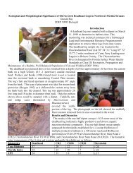
Overview<br />
Geographic Information Systems (GIS) methods <strong>and</strong> coverages provided the best available<br />
methods to calculate <strong>and</strong> depict different Class III waterbody types to which the Florida<br />
Department <strong>of</strong> Environmental Protection (<strong>FDEP</strong>) <strong>and</strong> United States Environmental Protection<br />
Agency (<strong>EPA</strong>) <strong>Numeric</strong> <strong>Nutrient</strong> <strong>Criteria</strong> (NNC) rules apply. The National Hydrography<br />
Dataset (NHD) is a database that depicts the nation’s surface waters. It contains features such as<br />
lakes, ponds, streams, rivers, <strong>and</strong> canals <strong>and</strong> is designed to be used in general mapping <strong>and</strong> in the<br />
analysis <strong>of</strong> surface water systems. <strong>FDEP</strong> used a December 12, 2012, release <strong>of</strong> the 1:24,000<br />
resolution NHD GIS base layer for this analysis. This data set is the st<strong>and</strong>ard surface water GIS<br />
layer in use for Florida’s Water Management Districts, <strong>FDEP</strong>, <strong>and</strong> the State Emergency<br />
Response Team. The base layer was used in conjunction with other spatial data layers, such as<br />
soils, l<strong>and</strong> use <strong>and</strong> salinity to conduct this analysis.<br />
Using ESRI’s ArcMap version 10.0 GIS s<strong>of</strong>tware, <strong>FDEP</strong> GIS staff performed spatial analysis to<br />
generate data layers that would most accurately represent surface water resources related to the<br />
respective <strong>FDEP</strong> <strong>and</strong> <strong>EPA</strong> NNC rules. The resultant coverages were exchanged via FTP sites<br />
with GIS staff for <strong>EPA</strong>. On January 17, 2013 a consultant for <strong>EPA</strong> met with Tallahassee staff<br />
<strong>and</strong> participated in a joint LIVE MEETING session with <strong>EPA</strong> staff in Washington DC <strong>and</strong><br />
Atlanta. During this meeting, all the details <strong>of</strong> the GIS methodology were discussed <strong>and</strong><br />
reviewed. DEP staff incorporated several <strong>EPA</strong> suggestions in a revised methodology <strong>and</strong> recreated<br />
several layers such as Freshwater Lakes. The following maps represent DEP’s depiction<br />
<strong>and</strong> areal estimate <strong>of</strong> the Department’s established <strong>and</strong> the <strong>EPA</strong> proposed NNC Summary Maps.<br />
Page 1
Page 2
Page 3
Page 4
DETAILED MAPS <strong>and</strong> GIS METHOD OVERVIEW<br />
GIS Analysis Resource Totals<br />
<strong>FDEP</strong> NNC <strong>Coverage</strong><br />
Waterbody Type<br />
Area<br />
<strong>FDEP</strong> Inl<strong>and</strong> Flowing Waters 347 mi. 2<br />
<strong>FDEP</strong> Fresh Water Lakes 2,548 mi. 2<br />
<strong>FDEP</strong> Estuaries 6,979 mi. 2<br />
<strong>FDEP</strong> Wetl<strong>and</strong>s 2,300 mi. 2<br />
<strong>FDEP</strong> Total 12,174 mi. 2<br />
Proposed <strong>EPA</strong> NNC <strong>Coverage</strong><br />
Waterbody Type<br />
Area<br />
<strong>EPA</strong> Tidal Creeks (proposed) 164 mi. 2<br />
<strong>EPA</strong> Marine Lakes (proposed) 4 mi. 2<br />
<strong>EPA</strong> Estuaries <strong>and</strong> Coastal (proposed) 5,746 mi. 2<br />
<strong>EPA</strong> Inl<strong>and</strong> Flowing Waters that are Likely C<strong>and</strong>idates for Stream Exception 24 mi. 2<br />
<strong>EPA</strong> Total 5,937 mi. 2<br />
Florida’s Goal<br />
Waterbody Type<br />
Area<br />
Inl<strong>and</strong> Flowing Waters 347 mi. 2<br />
Fresh Water Lakes 2,548 mi. 2<br />
Estuaries <strong>and</strong> Coastal 11,234 mi. 2<br />
Wetl<strong>and</strong>s 2,300 mi. 2<br />
Total 16,429 mi. 2<br />
Page 5
GIS Spatial Data Inventory<br />
<strong>FDEP</strong> Wetl<strong>and</strong> NNC - Depicts the area to which the Everglades phosphorus criterion is<br />
applicable.<br />
Page 6
<strong>FDEP</strong> Estuarine NNC - Depicts the areas to which <strong>FDEP</strong> estuarine NNC are applicable.<br />
Individual estuaries were combined <strong>and</strong> overlapping areas were removed to avoid duplication.<br />
Page 7
<strong>FDEP</strong> Freshwater Lakes NNC - Depicts the areas to which <strong>FDEP</strong> lakes NNC are applicable.<br />
The analysis was conducted using the December 2012 24K NHD. All lakes, ponds <strong>and</strong><br />
reservoirs were selected, regardless <strong>of</strong> size. Only the areas in Florida were counted for lakes<br />
straddling the Florida/Georgia or Alabama borders. Waterbodies such as swimming pools,<br />
ornamental ponds <strong>and</strong> fountains were excluded. Any areas overlapping areas to which <strong>FDEP</strong><br />
estuary, <strong>FDEP</strong> wetl<strong>and</strong>s, <strong>EPA</strong> estuary, <strong>EPA</strong> coastal segment, <strong>EPA</strong> <strong>of</strong>fshore (Big Bend), <strong>EPA</strong><br />
marine lake, or <strong>FDEP</strong> marine lake NNC apply were excluded.<br />
Page 8
<strong>FDEP</strong> Estuary <strong>and</strong> <strong>EPA</strong> Marine Lake NNC - Depicts the areas to which <strong>FDEP</strong> estuary <strong>and</strong><br />
<strong>EPA</strong> marine lake NNC are applicable. The analysis was conducted using a marine lakes GIS<br />
layer from <strong>EPA</strong>. <strong>FDEP</strong> staff conducted a detailed review <strong>of</strong> each marine lake. Lakes determined<br />
not to be marine or not to be a lake were excluded. The remaining lakes were divided into lakes<br />
for which either <strong>EPA</strong>’s marine lake NNC apply or were covered by one <strong>of</strong> <strong>FDEP</strong>’s estuarine<br />
NNC.<br />
Page 9
<strong>FDEP</strong> South <strong>Nutrient</strong> Watershed Region - Depicts the South <strong>Nutrient</strong> Watershed Region, for<br />
which neither <strong>FDEP</strong> nor <strong>EPA</strong> NNC are applicable at this time. <strong>FDEP</strong> is conducting extensive<br />
research to develop NNC for this area. This area is not included in either the estimate <strong>of</strong> <strong>FDEP</strong><br />
or <strong>EPA</strong> NNC.<br />
Page 10
<strong>FDEP</strong> Inl<strong>and</strong> Flowing Waters NNC - Depicts the areas to which <strong>FDEP</strong> inl<strong>and</strong> flowing waters<br />
NNC are applicable. The analysis was conducted using the December 2012 24K NHD. This<br />
coverage is a result <strong>of</strong> a merger between <strong>FDEP</strong>’s stream <strong>and</strong> river coverage <strong>and</strong> <strong>EPA</strong>’s inl<strong>and</strong><br />
canal <strong>and</strong> ditch coverage. All features were selected <strong>and</strong> only the areas in Florida were counted<br />
for waters straddling the Florida/Georgia or Alabama borders. Features identified as potentially<br />
Class IV waterbodies were excluded. Features that overlapped areas to which freshwater lake,<br />
marine lake or estuarine NNC apply were excluded to avoid double counting. Features seaward<br />
<strong>of</strong> the saltwater interface were also excluded to avoid double-counting.<br />
Page 11
<strong>EPA</strong> Tidal Creeks NNC - Depicts the areas to which <strong>EPA</strong> tidal creek NNC are applicable.<br />
The analysis was conducted using a tidal creek GIS coverage obtained from <strong>EPA</strong>.<br />
Segments that lie inside the area determined by <strong>FDEP</strong> as tidal creeks (see <strong>FDEP</strong> inl<strong>and</strong> flowing<br />
waters section for description <strong>of</strong> method) were selected. Segments were excluded that<br />
overlapped areas to which estuarine NNC apply to avoid double counting.<br />
Page 12
<strong>EPA</strong> Estuarine NNC - Depicts the areas to which <strong>EPA</strong>’s proposed estuarine NNC are<br />
applicable. The analysis was conducted using an estuarine NNC GIS coverage obtained from<br />
<strong>EPA</strong>. Any areas overlapping an area to which <strong>FDEP</strong> estuarine NNC apply were excluded to<br />
avoid double counting.<br />
Page 13
<strong>EPA</strong> Coastal Segments - Depicts the areas to which <strong>EPA</strong>’s proposed coastal NNC are<br />
applicable. The analysis was conducted using a coastal NNC GIS coverage obtained from <strong>EPA</strong>.<br />
Any areas overlapping an area to which <strong>FDEP</strong> Estuarine NNC apply were excluded to avoid<br />
double counting.<br />
Page 14
<strong>EPA</strong> Big Bend Offshore Segments Depicts the areas to which <strong>EPA</strong>’s proposed Big Bend<br />
<strong>of</strong>fshore NNC are applicable. The analysis was conducted using a Big Bend <strong>of</strong>fshore NNC GIS<br />
coverage obtained from <strong>EPA</strong>. Any areas overlapping an area to which <strong>FDEP</strong> Estuarine NNC<br />
apply were excluded to avoid double counting.<br />
Page 15
<strong>EPA</strong> Inl<strong>and</strong> Flowing Waters that are Likely C<strong>and</strong>idates to meet the provisions <strong>of</strong> 62-<br />
302.200(36)(a) <strong>and</strong> (b) 1 - Depicts the areas to which <strong>FDEP</strong> NNC may not be applicable due to<br />
being a: 1) tidal creek (flowing waters inl<strong>and</strong> <strong>of</strong> the saltwater interface to the 3.2 mi. buffer); or<br />
2) man-made or physically altered ditch, canal or other conveyance. These waters are those with<br />
either sufficient water quality data for assessment under the <strong>FDEP</strong> impaired waters rule, or those<br />
with an NPDES discharge.<br />
1 Flowing waters that meet the provisions in Subsection 62-302.200(36)(a) <strong>and</strong> (b), F.A.C.<br />
Page 16