- Page 1: U G A N D A Atlas of Our Changing E
- Page 4 and 5: © 2009, National Enviornment Manag
- Page 6 and 7: Chapter 2: Uganda’s Changing Envi
- Page 8 and 9: Foreword Hon. Maria Mutagamba MINIS
- Page 10 and 11: Sunset over Europe and Africa A dig
- Page 12 and 13: The beautiful ridges landscape in K
- Page 14 and 15: Wekesa George (S4. Seeta High Schoo
- Page 16 and 17: Geology Kilometres ) Atlas of Ugand
- Page 18 and 19: Climate Uganda experiences moderate
- Page 20 and 21: Rainfall distribution Kilometres At
- Page 22 and 23: Climatic zones Zone 1: Lake Victori
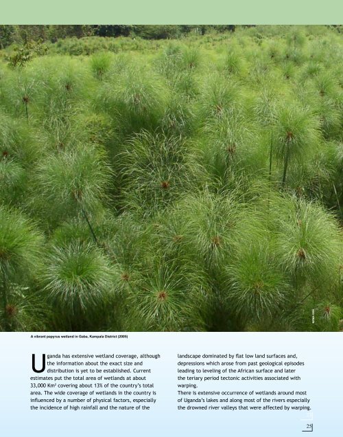
- Page 24 and 25: Water Resources NEMA 2006 NEMA 2008
- Page 26 and 27: Lake Water Levels Lake Victoria hig
- Page 28 and 29: River Basins, Lakes and Wetlands NE
- Page 30 and 31: Drainage NEMA 2008 Kilometres Direc
- Page 32 and 33: Ground water Simondwa 2006 Credit..
- Page 34 and 35: Land cover / Land use Legend CLASS
- Page 36 and 37: Land use Terraced gardens and inten
- Page 40 and 41: Ramsar Convention Name of Ramsar si
- Page 42 and 43: Wetlands: importance and uses Ugand
- Page 44 and 45: Wetlands: threats Indiscriminate du
- Page 46 and 47: Wetlands: interventions NEMA 2007 N
- Page 48 and 49: Plant a tree for the future: A girl
- Page 50 and 51: Forests NEMA 2009 An early morning
- Page 52 and 53: Conservation areas: Protected areas
- Page 54 and 55: Uganda Wildlife Authority (UWA) 200
- Page 56 and 57: Uganda Wildlife Authority (UWA) 200
- Page 58 and 59: Soils: General status Soils Acric F
- Page 60 and 61: Soils: Agro-Ecological Zones Agro-E
- Page 62 and 63: Agro-Ecological Rainfall Minimum Al
- Page 64 and 65: Energy: Hydro electric power NEMA (
- Page 66 and 67: Energy: different sources of energy
- Page 68 and 69: NEMA file photo (2008) Kasese Cobal
- Page 70 and 71: More pictures of Game parks /wildli
- Page 72 and 73: K I R U Kiruhura 1990 NEMA file pho
- Page 74 and 75: Karamoja Karamoja Increase in agric
- Page 76 and 77: Kibimba Rice Scheme Ten years ago,
- Page 78 and 79: a Mabira 2001 Mabira forest 2001 Ma
- Page 80 and 81: Part of the Mabira Tropical High Fo
- Page 82 and 83: Katuugo Forest 1990, Nakasongola Di
- Page 84 and 85: I 70 Budongo Forest Reserve Decreas
- Page 86 and 87: Budongo fire fronts 2002 Budongo fi
- Page 88 and 89:
u g o u g o 74 Katuugo Forest Reser
- Page 90 and 91:
76 Mwenge - Mafuga Forest Reserves
- Page 92 and 93:
Rhino camp 1975 78 Pader Refugee ca
- Page 94 and 95:
Kooki Hills Area Degraded hills The
- Page 96 and 97:
Rakai District Local Administration
- Page 98 and 99:
Rakai District Local Administration
- Page 100 and 101:
Budongo Forest 1974 Mt. Elgon Natio
- Page 102 and 103:
NEMA 2008 Dawn at the Mt. Elgon Ran
- Page 104 and 105:
Lake Wamala Wetland degradation Lak
- Page 106 and 107:
NEMA 2007 Kabale-Iyamuriro wetland
- Page 108 and 109:
Aerial view of Kabale-Iyamuriro wet
- Page 110 and 111:
Lake Mutanda Rapid silting and wetl
- Page 112 and 113:
District State of Environment Repor
- Page 114 and 115:
Laropi- Moyo lakes/ lagoons Floods
- Page 116 and 117:
Bridge before 1998 floods Bridge af
- Page 118 and 119:
Teso region Flooding The northern p
- Page 120 and 121:
Kampala Urbanisation and industrial
- Page 122 and 123:
Kampala City (2005) Kampala City (2
- Page 124 and 125:
. . . . . 110
- Page 126 and 127:
Naguru-Kololo in 1959 In 1959, Kamw
- Page 128 and 129:
Bugolobi in 1959 Unplanned settleme
- Page 130 and 131:
. Clock T Flood prone area at Clock
- Page 132 and 133:
Bwaise . 118 Construction in the Ns
- Page 134 and 135:
. 120 Construction in waterways at
- Page 136 and 137:
Namuwongo . Construction of houses
- Page 138 and 139:
Naguru Housing Estate Nakawa market
- Page 140 and 141:
Biomass Land use/land cover Land us
- Page 142 and 143:
Positive impacts of Kampala’s cha
- Page 144 and 145:
A NEMA 2008 Some of the landmarks i
- Page 146 and 147:
132 NEMA 2008
- Page 148 and 149:
NEMA 2008 Mt. Elgon borders Uganda
- Page 150 and 151:
Changes in glacial extent: Rwenzori
- Page 152 and 153:
River Semliki Eroded banks of River
- Page 154 and 155:
NEMA 2006 NEMA 2007 NEMA 2007 A her
- Page 156 and 157:
142 Kagera River Siltation of Lake
- Page 158 and 159:
144 Lake Victoria Green algae bloom
- Page 160 and 161:
AA 146 Lake Kyoga Shallow lake, uns
- Page 162 and 163:
NEMA 2006 NEMA staff and Lira Distr
- Page 164 and 165:
150 Kasyoha- Kitomi Forest Reserve
- Page 166 and 167:
Location of Yoro Location of Yoro 1
- Page 168 and 169:
NEMA 2007 Misuse of seasonal wetlan
- Page 170 and 171:
Uganda’s economy More than 73% of
- Page 172 and 173:
Millennium Development Goals (MDGs)
- Page 174 and 175:
MDG 7: Ensure Environmental Sustain
- Page 176 and 177:
The 2000-2005 growth rate in Africa
- Page 178 and 179:
John Gibbons: Uganda At A Glance 20
- Page 180 and 181:
Literacy rate Literacy rates for th
- Page 182 and 183:
Tourism and the Environment Tourist
- Page 184 and 185:
Land use and land cover Over 36 per
- Page 186 and 187:
Forest Reserves Central Forest Rese
- Page 188 and 189:
and Ntungamo had the percentage of
- Page 190 and 191:
Latrine Coverage The use of proper
- Page 192 and 193:
Energy for cooking in 2005-2006 Ene
- Page 194 and 195:
Arable land Almost all Uganda’s l
- Page 196 and 197:
Recommendations 1. Efforts to reduc
- Page 198 and 199:
NEMA 2006 184 Kika Group, a local d
- Page 200 and 201:
Wildlife Where is my food- The Gira
- Page 202 and 203:
Biodiversity NEMA 2006 NEMA 2008 Ec
- Page 204 and 205:
Areas of interest Houses of Parliam
- Page 206 and 207:
Nature A modern country homestead n
- Page 208 and 209:
Places of worship Namirembe Cathedr
- Page 210 and 211:
Traditional aspects Gisu Imbalu (ci
- Page 212 and 213:
Crater lakes in Uganda 198
- Page 214 and 215:
Acronyms AEZ AIDS AKDN AKFED AMCOW
- Page 216 and 217:
Index A Abim 60,181 Abstraction 18
- Page 218 and 219:
Montane forests 90 Moon x Moroto 60
- Page 220:
The Uganda Atlas of Our Changing En