Halliburton Reservoir Contact Workflow
Halliburton Reservoir Contact Workflow
Halliburton Reservoir Contact Workflow

Create successful ePaper yourself
Turn your PDF publications into a flip-book with our unique Google optimized e-Paper software.
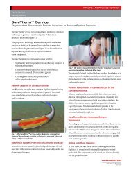
HALLIBURTON<br />
Measure actual reservoir properties using any of our best in<br />
class downhole tools including: Azimuthal Lithodensity (ALD)<br />
Sensor, Insite ADR Azimuthal Deep Resistivity Sensor, Insite<br />
AFR Azimuthal Focused Resistivity Sensor, ABG<br />
(At-Bit Gamma) Sensor.<br />
• Correlate measured log responses with predicted logs.<br />
• Use logging-while-drilling data from real-time drilling<br />
operations to update geological models and plans.<br />
• Map distance to bed boundaries.<br />
Optimize wellbore paths across the asset to exploit most<br />
productive reservoir zones by updating geological interpretations<br />
to match actual subsurface measurements. Adjust your well paths<br />
to hit most productive zones. Benefit from complete data<br />
connectivity between Openworks®, InSite®, and EDM applications<br />
based on WITSML standards.<br />
• Geoscientists can optimize earth models in the<br />
OpenWorks database.<br />
• Drilling engineers can optimize well plans in EDM software.<br />
• Geosteering engineers can optimize real-time drilling<br />
plans in the InSite system.<br />
By monitoring real-time measurements from logging while<br />
drilling tools, our geosteering engineers can identify faults and<br />
bed boundaries that were not predicted and make adjustments to<br />
the well path to avoid non productive intervals. Bringing any<br />
consulting experience you need to your wellsite from across<br />
<strong>Halliburton</strong>, including Sperry, Project Management and<br />
Consulting, and Landmark Software and Services, we work with<br />
your asset team to share knowledge and produce results. We will<br />
update your grids, surfaces, and faults based on real-time<br />
measurements and send them to your OpenWorks and EDM<br />
environment so you can leverage the data streaming from our<br />
downhole tools in each wellsite to enhance the accuracy of<br />
operations around your asset.<br />
We will put your well bore in the precise location to maximize<br />
potential recovery, and deliver all data directly into your<br />
Landmark application environment including:<br />
• Structural model<br />
• Surfaces<br />
• Faults<br />
• Well picks<br />
• Control points<br />
• Fault picks<br />
To non-Landmark users, we deliver:<br />
• The structural model, including surfaces, in ZMAP<br />
format (does not include faults, well picks, control points,<br />
and fault picks)<br />
• All logging-while-drilling data<br />
We will deploy a <strong>Reservoir</strong> <strong>Contact</strong> workflow that’s customized<br />
according to your needs, directed or supported from any location:<br />
• Remotely from our real-time operating center<br />
• At your real-time operating center<br />
• Portable solution at your well site<br />
• Application hosting and onsite support<br />
For more information, contact your local <strong>Halliburton</strong> representative or<br />
visit us on the web at www.halliburton.com<br />
© 2011 <strong>Halliburton</strong>. All rights reserved. Sales of <strong>Halliburton</strong> products and services will be in accord solely with the terms and conditions contained in the<br />
contract between <strong>Halliburton</strong> and the customer that is applicable to the sale. H07920-A4 10/11<br />
www.halliburton.com<br />
HALLIBURTON