Township of Rockaway DRAFT Highlands Element for Municipal ...
Township of Rockaway DRAFT Highlands Element for Municipal ...
Township of Rockaway DRAFT Highlands Element for Municipal ...

Create successful ePaper yourself
Turn your PDF publications into a flip-book with our unique Google optimized e-Paper software.
<strong>DRAFT</strong> <strong>Highlands</strong> <strong>Element</strong> to the <strong>Rockaway</strong> <strong>Township</strong> Master Plan November 2010<br />
LAND PRESERVATION AND LAND STEWARDSHIP PLAN<br />
The existing Master Plan has an Open Space and Recreation Plan <strong>Element</strong> providing detailed<br />
in<strong>for</strong>mation on existing and proposed open space preservation and recreational<br />
opportunities in the community. This Plan supplements the existing <strong>Element</strong>, as applicable<br />
to the <strong>Highlands</strong> Area, to include the additional in<strong>for</strong>mation and goals and objectives listed<br />
below.<br />
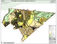
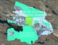
A mapped inventory <strong>of</strong> Preserved Lands in the <strong>Township</strong> <strong>Highlands</strong> Area, appears at Exhibit<br />
Z, “Preserved Lands” (duplicated from the ERI). This Plan in addition incorporates (from the<br />
ERI) Exhibit AA, “<strong>Highlands</strong> Conservation Priority Areas,” Exhibit BB, “<strong>Highlands</strong> Special<br />
Environmental Zone,” Exhibit CC, “Preserved Farms, SADC Easements, All Agricultural Uses”<br />
and Exhibit DD, “Important Farmland Soils”, This Plan recognizes and incorporates the<br />
definitions, derivations and delineations used to develop these maps, as provided in the ERI.<br />
Preserved Lands in the <strong>Township</strong> <strong>Highlands</strong> Area include lands under ownership by the<br />
municipality, the county, the state, the federal government and non-pr<strong>of</strong>it land trusts. In<br />
addition, Preserved Lands includes dedicated easements (such as Conservation Easements)<br />
to the extent these are currently known and identified (i.e., by deed description) <strong>for</strong><br />
mapping purposes. (The Planning Board recognizes and will address the need <strong>for</strong> a more<br />
complete inventory <strong>of</strong> all such easements after Basic Plan Con<strong>for</strong>mance has been attained,<br />
with the assistance <strong>of</strong> the <strong>Highlands</strong> Council.) In total, the map indicates 7,622 acres <strong>of</strong><br />
Preserved Lands.<br />
<strong>Highlands</strong> Conservation Priority Area lands are those designated a high priority <strong>for</strong><br />
preservation due to exceptional water and ecological resource value. The priority order<br />
derives from the <strong>Highlands</strong> Council Resource Assessment methodology, which identifies<br />
and ranks <strong>Highlands</strong> lands based on a combination <strong>of</strong> indicators, including but not limited<br />
to: watershed conditions, <strong>Highlands</strong> Open Waters, riparian areas, prime ground water<br />
recharge areas, <strong>for</strong>ests, critical habitat and steep slopes.<br />
Lands within the <strong>Highlands</strong> Special Environmental Zone are those having the highest<br />
priority ranking <strong>for</strong> preservation based on the <strong>Highlands</strong> Council Resource Assessment and<br />
<strong>for</strong> which development is expressly prohibited. Preservation <strong>of</strong> these lands is vital to: a)<br />
protecting <strong>Highlands</strong> Area water resources and environmentally sensitive lands; b)<br />
protecting water supply reservoirs and other critical water features; c) creating large<br />
contiguous areas <strong>of</strong> environmentally sensitive lands; d) creating habitat corridors; and e)<br />
connecting existing preserved open space.<br />
All Agricultural Uses includes lands currently serving farming and/or other agricultural<br />
purposes, whether permanently deed restricted or not. The map <strong>of</strong> Important Farmland<br />
Soils provides a delineation <strong>of</strong> the four farmland soil classifications as prepared by the U.S.<br />
Department <strong>of</strong> Agriculture (USDA), NRCS, Soil Survey Geographic Database <strong>for</strong> farmland soil<br />
quality, including:<br />
- 47 -