Place: Ballater Park - Hume City Council
Place: Ballater Park - Hume City Council
Place: Ballater Park - Hume City Council

Create successful ePaper yourself
Turn your PDF publications into a flip-book with our unique Google optimized e-Paper software.
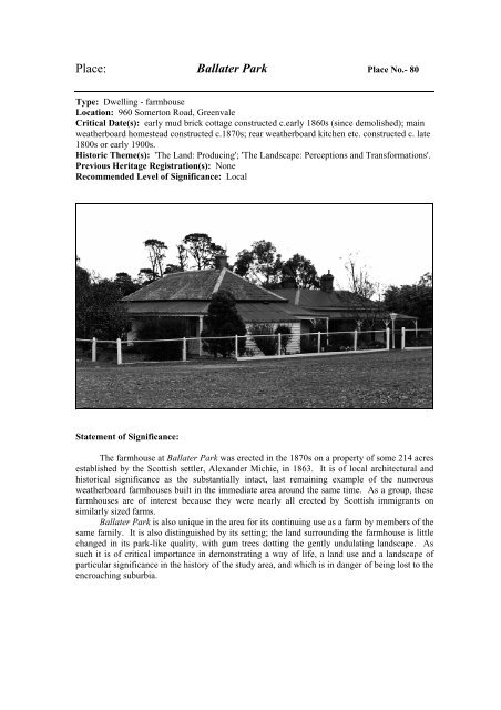
<strong>Place</strong>: <strong>Ballater</strong> <strong>Park</strong> <strong>Place</strong> No.- 80<br />
Type: Dwelling - farmhouse<br />
Location: 960 Somerton Road, Greenvale<br />
Critical Date(s): early mud brick cottage constructed c.early 1860s (since demolished); main<br />
weatherboard homestead constructed c.1870s; rear weatherboard kitchen etc. constructed c. late<br />
1800s or early 1900s.<br />
Historic Theme(s): 'The Land: Producing'; 'The Landscape: Perceptions and Transformations'.<br />
Previous Heritage Registration(s): None<br />
Recommended Level of Significance: Local<br />
Statement of Significance:<br />
The farmhouse at <strong>Ballater</strong> <strong>Park</strong> was erected in the 1870s on a property of some 214 acres<br />
established by the Scottish settler, Alexander Michie, in 1863. It is of local architectural and<br />
historical significance as the substantially intact, last remaining example of the numerous<br />
weatherboard farmhouses built in the immediate area around the same time. As a group, these<br />
farmhouses are of interest because they were nearly all erected by Scottish immigrants on<br />
similarly sized farms.<br />
<strong>Ballater</strong> <strong>Park</strong> is also unique in the area for its continuing use as a farm by members of the<br />
same family. It is also distinguished by its setting; the land surrounding the farmhouse is little<br />
changed in its park-like quality, with gum trees dotting the gently undulating landscape. As<br />
such it is of critical importance in demonstrating a way of life, a land use and a landscape of<br />
particular significance in the history of the study area, and which is in danger of being lost to the<br />
encroaching suburbia.
History and Description:<br />
The land on which <strong>Ballater</strong> <strong>Park</strong> is situated, allotment R of Section 10 of the Parish of<br />
Yuroke, was originally part of a station occupied by a Major Firebrace, and it appears that his<br />
outstation was located a short distance to the east of the present homestead. 1<br />
Allotment R of Section 10 was purchased from the Crown by a John Haslet in 1849; he<br />
paid £1 per acre for the 314 acres. The title then passed through the hands of several owners<br />
until Alexander and Esther Michie, ancestors of the present owners, purchased 214 acres of the<br />
property in 1863. The other 100 acres was, by 1863, owned by a Samuel Hatty. 2<br />
No records have yet been located concerning the arrival of the Michies in the Port<br />
Phillip District, but Alexander Michie was born in Aberdeen in 1823 3 and the name they gave<br />
to their property is said to have come from Esther's birthplace in Scotland. 4<br />
In their descriptions of Alexander Michie's land, some of the earliest entries in the<br />
Broadmeadows Road Board Rate Books 5 note the location of his 'farm', or sometimes 'house<br />
and land', as being variously at 'Green Gully' 6 or 'Yuroke'. 7 The area 'Green Gully' referred to<br />
the general location where Hatty, Michie, and two other Scottish immigrants John and Donald<br />
McKerchar had settled. Their land fronted what was then called the Deep Creek Road. This<br />
road was also known as McKerchar's Lane, then Green Gully Road, then later as Greenvale<br />
Road, and is now called Somerton Road. The name 'Green Vale' was not used to refer to this<br />
area, once part of a larger district called Euroke or Yuroke, until about 1868; 8 it came from the<br />
name that Michie's eastern neighbour, John McKerchar, had given to his property.<br />
The first house that the Michies lived in was a small mud brick cottage, long since<br />
demolished, with earth floors that were dampened to keep it compacted, and then covered with<br />
hessian. The walls were whitewashed and it had a hipped roof. 9 Some time later, possibly in<br />
the 1870s, the present homestead was separately erected in front of this cottage, which, with<br />
some weatherboard additions, then became the kitchen because it contained a stove. 10<br />
The present weatherboard homestead is substantially intact and has no architectural<br />
pretensions, appearing instead much like any colonial vernacular farmhouse, with its hip roof<br />
(broken by a valley to cover an uneven plan at the rear) and a deep encircling verandah. The<br />
roof is covered with what are probably the original slate tiles, and the chimneys are rendered.<br />
The verandah is sheeted with corrugated iron, and the timber verandah posts are simply detailed<br />
at the top.<br />
At a later stage, possibly late in the nineteenth century or early in the twentieth century,<br />
the mud-brick cottage was demolished and a separate weatherboard structure, larger in size and<br />
located more directly behind the farmhouse, was erected. This also was used to house the<br />
kitchen (still its function), and some other rooms. It has an M-shaped roofline sheeted with<br />
corrugated iron.<br />
1 'Plan showing the Portions Subdivided in Yuroke, Bulla Bulla and Tullamarine', 1847, Historical<br />
Plan OR Y1, CPO.<br />
2 Much of the historical information comes from Annette Ferguson's well-researched history of the<br />
Greenvale area called 'Greenvale: Links with the past', which was written c.1985. A copy of the<br />
unpublished typescript is held at the Sunbury Regional Library; also Current Parish Plan, Parish of<br />
Yuroke, CPO; also PROV, VPRS 7959/P1, Unit 1, Broadmeadows Road Board Rate Book 1863-<br />
1870.<br />
3 Entry for the Michie family, No.M25480, in VicGold Genealogy Database, Internet URL<br />
http://www.ke.com.au.<br />
4 Ferguson, op.cit., np.<br />
5 Rate Books, op.cit.<br />
6 For example - rates made in 1864, '65 and '66.<br />
7 For example - rates made in 1863, '67 and '68.<br />
8 Rate Books, op.cit.<br />
9 Ferguson, op.cit., np. citing a grandaughter of Michie, Margaret Lofts, who used to live in the<br />
house.<br />
10 From personal conversation with the current owners.
Alexander Michie died in October 1896 and his assets were described in his Probate<br />
papers as 214 acres with a six-roomed weatherboard cottage and outhouses. 11 These<br />
documents also noted that the property was used for grazing purposes only and no area had been<br />
cultivated. Esther remained at the farmhouse until her death in 1911 at the age of 87. Their<br />
daughter, Annie, one of seven children, married a Robert Millar and they lived at a farm called<br />
Springbank (once located in what is now the Attwood area). They moved back into <strong>Ballater</strong><br />
<strong>Park</strong> after Michie's death, changing it from the dairy farm it had always been to a sheep farm.<br />
Their son, Alexander Millar, later rented the adjoining Green Vale property, and in the 1920s<br />
renamed it The Elms. Alexander later moved to Cairn Brae on St.Johns Rd., which had been<br />
built by his uncle, William Michie, but <strong>Ballater</strong> <strong>Park</strong> remained in the family. The present<br />
owners are the daughters of Alexander Millar. 12<br />
Along the road travelling east towards Somerton there was once a fair number of these<br />
small farms of some 200 to 400 acres with weatherboard farmhouses, all settled in the 1850s<br />
and 1860s by Scottish and English settlers. Today most are gone. Nothing is said to remain of<br />
Green Vale (or The Elms) the last remains having apparently been torn down recently. 13<br />
Greenan, the farmhouse of McKerchar's brother, Donald, burnt down some years ago leaving<br />
only a bluestone outbuilding as a reminder of its existence. The properties Glen Arthur and<br />
Waltham, situated further east and owned respectively by Joseph Trotman and Robert<br />
Shankland, were destroyed to make way for the Greenvale Reservoir. Others such as Fairview,<br />
owned by John Bond and once located opposite Glen Arthur, have made way for new residential<br />
developments. It seems that the only other weatherboard farmhouse left from this era is the<br />
former Springfield, which is located on what is now called French Road but is altered almost<br />
beyond recognition. <strong>Ballater</strong> <strong>Park</strong> is unique in the area in that its farmhouse is still<br />
substantially unaltered from the original, and the land surrounding it is little changed in its parklike<br />
quality, with gum trees dotting the gently undulating landscape.<br />
Recommendations:<br />
It is recommended that <strong>Ballater</strong> <strong>Park</strong> homestead and outbuildings be included in the<br />
Heritage Overlay of the <strong>Hume</strong> Planning Scheme. It is further recommended that the <strong>Council</strong><br />
consider the whole property for Significant Landscape Overlay controls.<br />
11 PROV, VPRS 28/P2, Unit 427, Record 352 of Series 60.<br />
12 From personal conversation with the current owners; and Ferguson, op.cit.<br />
13 Information from the present owner of The Elms.