Catalyzing Climate and Disaster Resilience: Processes for Identifying
Catalyzing Climate and Disaster Resilience: Processes for Identifying
Catalyzing Climate and Disaster Resilience: Processes for Identifying

Create successful ePaper yourself
Turn your PDF publications into a flip-book with our unique Google optimized e-Paper software.
16<br />
<strong>Catalyzing</strong> <strong>Climate</strong> <strong>and</strong> <strong>Disaster</strong> <strong>Resilience</strong>: <strong>Processes</strong> <strong>for</strong><br />
<strong>Identifying</strong> Tangible <strong>and</strong> Economically Robust Strategies<br />
BOX 1<br />
The Kosi Embankment Breach<br />
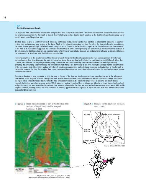
On August 18, 2008 a flood control embankment along the Kosi River in Nepal Tarai breached. The failure occurred when flow in that river was below<br />
the long-term average flow <strong>for</strong> the month of August. Over the following weeks a disaster slowly unfolded as the Kosi River began flowing along one of<br />
its old courses east of its previous one.<br />
The Kosi drains an area of 60,000 km 2 in Tibet, Nepal <strong>and</strong> North Bihar (India). In one year the river transfers an estimated 95 million m 3 of sediment<br />
derived from l<strong>and</strong>slides <strong>and</strong> mass wasting to the Ganga. Much of the sediment is deposited in a huge fan where the river exits from the mountains to<br />
the plains. This exceptionally high load of sediment is brought down to Chatara in the Tarai <strong>and</strong> is dumped on the riverbed as the river slope levels off.<br />
In the past, as its main channel aggraded, the Kosi had naturally shifted its course. In the preceding 220 years the river had oscillated over a stretch of<br />
115 kilometres. In 1959 this natural process was interrupted when the river was jacketed between two embankments following an agreement between<br />
the governments of Nepal <strong>and</strong> India that had taken place in 1954.<br />
Following completion of the Kosi Barrage in 1964, the river gradient changed <strong>and</strong> sediment deposition in the river section upstream of the barrage<br />
increased rapidly. Over time, this raised the level of the riverbed above the surrounding l<strong>and</strong>, a factor that contributed to the 2008 breach. When that<br />
occurred, the main river discharge began flowing along a course that had been blocked by the eastern embankment. Instead of permanently<br />
protecting the surrounding area from floods, the embankments had changed the morphology of the river, raising the jacketed channel above the level<br />
of the surrounding l<strong>and</strong>. Other factors leading to the breach include poor maintenance <strong>and</strong> institutional corruption <strong>and</strong> dysfunction in the aftermath of<br />
Nepal-India treaty on the river. The resulting flood caused widespread inundation <strong>and</strong> concomitant adverse effects on the social <strong>and</strong> economic systems<br />
dependent on the river.<br />
Once the embankments were completed in 1959, the area to the east of the river was largely protected from major flooding <strong>and</strong> in the subsequent<br />
four decades roads, irrigation channels, railways <strong>and</strong> other features were constructed. These developments blocked the natural drainage <strong>and</strong> divided<br />
the region into a series of enclosed basins. When the Kosi embankment breached, the waters no longer flowed in one or a few clearly defined<br />
channels, but instead spread out across a width of 30-40 kilometres seeking the path of least resistance <strong>and</strong> filling the enclosed basins, low-lying l<strong>and</strong>s<br />
<strong>and</strong> ponds. Low points were scoured <strong>and</strong> trans<strong>for</strong>med into new main channels <strong>for</strong> the river, <strong>and</strong> s<strong>and</strong> <strong>and</strong> sediment were deposited across fields <strong>and</strong> in<br />
irrigation channels, drainage ditches <strong>and</strong> other structures. In addition, approximately 50,000 people in Nepal <strong>and</strong> more than three million in India were<br />
displaced <strong>and</strong> lives were lost.<br />
| FIGURE 3 | Flood inundation map of part of North Bihar state<br />
<strong>and</strong> part of Nepal Tarai, satellite image of<br />
September 3, 2008<br />
| FIGURE 4 | Changes in the course of the Kosi,<br />
1700 - 2000<br />
Source: Gole <strong>and</strong> Chitale, 1966<br />
Adapted from: NRSA, Dept. of Space, Govt. of India<br />
(Based on the analysis of Radarsat-2 data of September 3, 2008)