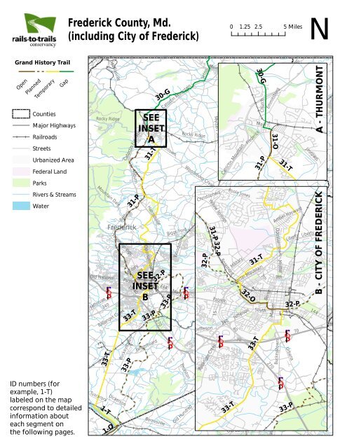
Frederick County, Md. - Rails-to-Trails Conservancy
Frederick County, Md. - Rails-to-Trails Conservancy
Frederick County, Md. - Rails-to-Trails Conservancy

You also want an ePaper? Increase the reach of your titles
YUMPU automatically turns print PDFs into web optimized ePapers that Google loves.
Church<br />
<strong>Frederick</strong> <strong>County</strong>, <strong>Md</strong>.<br />
(including City of <strong>Frederick</strong>)<br />
N<br />
0 1.25 2.5 5 Miles<br />
Grand His<strong>to</strong>ry Trail<br />
Open<br />
Planned<br />
Temporary<br />
Gap<br />
Counties<br />
Major Highways<br />
Railroads<br />
Streets<br />
Urbanized Area<br />
Federal Land<br />
Sabillasville<br />
Rocky Ridge<br />
Ca<strong>to</strong>ctin Furnace<br />
Church<br />
Main<br />
31-T<br />
30-G<br />
SEE<br />
INSET<br />
A<br />
Ca<strong>to</strong>ctin Mountain<br />
Jim<strong>to</strong>wn<br />
Se<strong>to</strong>n<br />
Rocky Ridge<br />
Main<br />
Motters Station<br />
Taney<strong>to</strong>wn<br />
Woodsboro<br />
Ca<strong>to</strong>ctin Mountain<br />
30-G<br />
<strong>Frederick</strong><br />
31-P<br />
Carroll<br />
Main<br />
Emmitsburg<br />
Middleburg<br />
31-O<br />
31-T<br />
Baptist<br />
Baptist<br />
Francis Scott Key<br />
Jim<strong>to</strong>wn<br />
A - THURMONT<br />
75<br />
Locust<br />
Woodsboro Creagers<strong>to</strong>wn<br />
Auburn<br />
Parks<br />
Rivers & Streams<br />
Water<br />
Mountain Dale<br />
Old National<br />
Jefferson<br />
340<br />
Ballenger Creek<br />
33-T<br />
Bethel<br />
<strong>Frederick</strong><br />
Yellow Springs<br />
Patrick<br />
15<br />
Buckeys<strong>to</strong>wn<br />
Military<br />
40<br />
7th<br />
Market<br />
Hansonville<br />
Opossum<strong>to</strong>wn<br />
South<br />
70<br />
270<br />
Fingerboard<br />
144<br />
Biggs Ford<br />
Woodsboro<br />
Main<br />
Liberty<br />
§¨¦ §¨¦ 70 B<br />
70<br />
§¨¦ 70<br />
§¨¦ 270<br />
33-P<br />
31-P<br />
SEE<br />
INSET<br />
33-T<br />
33-P<br />
32-P<br />
33-P<br />
Chris<strong>to</strong>phers<br />
32-P<br />
Urbana<br />
Yellow Springs<br />
Main<br />
31-P<br />
Jefferson<br />
32-P<br />
Old National<br />
Patrick<br />
15<br />
Ballenger Creek<br />
Rosemont<br />
340<br />
Fingerboard<br />
Poole Jones<br />
Woodsboro<br />
Military<br />
Green Valley<br />
Woodsboro<br />
7th<br />
Ca<strong>to</strong>ctin Mountain<br />
40<br />
Jefferson<br />
70<br />
32-O<br />
Green Valley<br />
Walnut<br />
Bentz<br />
South<br />
Green Valley<br />
Old National<br />
Market<br />
270<br />
Amber<br />
Opossum<strong>to</strong>wn<br />
Motter<br />
Buckeys<strong>to</strong>wn<br />
9th<br />
New Windsor<br />
70<br />
§¨¦ 70 §¨¦ 70<br />
33-T<br />
31-T<br />
Hayward<br />
Liberty<br />
32-P<br />
Urbana<br />
Ridge<br />
Gue<br />
Tuscarora<br />
Dickerson<br />
Barnesville<br />
Thurs<strong>to</strong>n<br />
Old Hundred<br />
Comus<br />
Lewisdale<br />
Clarksburg<br />
Old Baltimore<br />
<strong>Frederick</strong><br />
Burnt Hill<br />
Bethesda Church<br />
Liberty<br />
70<br />
Kemp<strong>to</strong>wn<br />
Liberty<br />
B - CITY OF FREDERICK<br />
144<br />
Main<br />
ID numbers (for<br />
example, 1-T)<br />
labeled on the map<br />
correspond <strong>to</strong> detailed<br />
information about<br />
each segment on<br />
the following pages.<br />
1-T<br />
1-O<br />
Montgomery<br />
33-T<br />
Ridge<br />
§¨¦ 270<br />
Main<br />
Sweepstakes<br />
33-P<br />
Damascus<br />
Woodfield
Grand His<strong>to</strong>ry Trail<br />
Corridor Segment Analysis<br />
<strong>Frederick</strong> <strong>County</strong> (including City of <strong>Frederick</strong>)<br />
30-G<br />
Emmitsburg <strong>to</strong> Thurmont On-Street<br />
Route<br />
Status: Gap<br />
Length in miles: 9.70<br />
Location: <strong>Frederick</strong> <strong>County</strong>, <strong>Md</strong>.<br />
This on-road section is a gap in the grand His<strong>to</strong>ry Trail route<br />
where no off-road trail is planned. It connects Emmitsburg, <strong>Md</strong>.,<br />
<strong>to</strong> Thurmont, <strong>Md</strong>., via roads including South Sea<strong>to</strong>n Avenue,<br />
Old Emmitsburg Road, Kelbaugh Road and Church Street/<br />
Sabillasville Road. GIS data and route information by <strong>Rails</strong>-<strong>to</strong>-<br />
<strong>Trails</strong> <strong>Conservancy</strong> and verified by <strong>Frederick</strong> <strong>County</strong> Department<br />
of Planning.<br />
31-O<br />
H&F Trolley Trail<br />
Status: Open<br />
Length in miles: 0.72<br />
Location: <strong>Frederick</strong> <strong>County</strong>, <strong>Md</strong>.<br />
www.dnr.state.md.us/greenways/counties/<br />
frederick.html<br />
The H&F Trolley Trail follows an out-of-service Hagers<strong>to</strong>wn &<br />
<strong>Frederick</strong> Railway trolley right-of-way from Thurmont, <strong>Md</strong>.,<br />
<strong>to</strong> Fredrick, <strong>Md</strong>., on which the Hagers<strong>to</strong>wn and <strong>Frederick</strong><br />
(H&F) Railroad operated electric trolleys from 1908 <strong>to</strong> 1953.<br />
The right-of-way is approximately 30 <strong>to</strong> 35 feet in width and<br />
still accommodates electric utility lines. Destinations along the<br />
corridor include Cunningham Falls State Park and the Ca<strong>to</strong>ctin<br />
Furnace, the Utica covered bridge, Ca<strong>to</strong>ctin Zoo, and the Yellow<br />
Springs and Lewis<strong>to</strong>wn elementary schools. At the moment,<br />
only one section is open; it is located in Thurmont between<br />
East Main Street and Water Street and opened in 1998 after<br />
being constructed by the <strong>to</strong>wn of Thurmont. GIS data by <strong>Rails</strong><strong>to</strong>-<strong>Trails</strong><br />
<strong>Conservancy</strong>; route information by <strong>Frederick</strong> <strong>County</strong><br />
Department of Planning.<br />
31-P<br />
H&F Trolley Trail<br />
Status: Planned<br />
Length in miles: 13.59<br />
Location: <strong>Frederick</strong> <strong>County</strong>, <strong>Md</strong>.<br />
www.dnr.state.md.us/greenways/counties/<br />
frederick.html<br />
The H&F Trolley Trail follows an out-of-service Hagers<strong>to</strong>wn &<br />
<strong>Frederick</strong> Railway trolley right-of-way from Thurmont, <strong>Md</strong>.,<br />
<strong>to</strong> Fredrick, <strong>Md</strong>., on which the Hagers<strong>to</strong>wn and <strong>Frederick</strong><br />
(H&F) Railroad operated electric trolleys from 1908 <strong>to</strong> 1953.<br />
The right-of-way is approximately 30 <strong>to</strong> 35 feet in width and<br />
still accommodates electric utility lines. Destinations along the<br />
corridor include Cunningham Falls State Park and the Ca<strong>to</strong>ctin<br />
Furnace, the Utica covered bridge, Ca<strong>to</strong>ctin Zoo, and the Yellow<br />
Springs and Lewis<strong>to</strong>wn elementary schools. The majority of the<br />
trail, from East Moser Road in Thurmont <strong>to</strong> Tuscany Drive (near<br />
Yellow Springs Road) in <strong>Frederick</strong>, is planned, as identified in<br />
the <strong>Frederick</strong> <strong>County</strong> Bikeways & <strong>Trails</strong> Plan. GIS data by <strong>Rails</strong><strong>to</strong>-<strong>Trails</strong><br />
<strong>Conservancy</strong>; route information by <strong>Frederick</strong> <strong>County</strong><br />
Department of Planning.
31-T<br />
H&F Trolley Trail<br />
Status: Temporary<br />
Length in miles: 17.37<br />
Location: <strong>Frederick</strong> <strong>County</strong>, <strong>Md</strong>.<br />
www.dnr.state.md.us/greenways/counties/<br />
frederick.html<br />
The H&F Trolley Trail follows an out-of-service Hagers<strong>to</strong>wn &<br />
<strong>Frederick</strong> Railway trolley right-of-way from Thurmont, <strong>Md</strong>.,<br />
<strong>to</strong> Fredrick, <strong>Md</strong>., on which the Hagers<strong>to</strong>wn and <strong>Frederick</strong><br />
(H&F) Railroad operated electric trolleys from 1908 <strong>to</strong> 1953.<br />
The right-of-way is approximately 30 <strong>to</strong> 35 feet in width and<br />
still accommodates electric utility lines. Destinations along the<br />
corridor include Cunningham Falls State Park and the Ca<strong>to</strong>ctin<br />
Furnace, the Utica covered bridge, Ca<strong>to</strong>ctin Zoo, and the<br />
Yellow Springs and Lewis<strong>to</strong>wn elementary schools. A temporary<br />
route along <strong>Frederick</strong> <strong>County</strong> roads, including Taney Avenue,<br />
Thomas Johnson Drive, Willowbrook Road, Old <strong>Frederick</strong> Road,<br />
Hessong Bridge Road and Moser Road, has been identified by<br />
the <strong>Frederick</strong> <strong>County</strong> Department of Planning and <strong>Rails</strong>-<strong>to</strong>-<br />
<strong>Trails</strong> <strong>Conservancy</strong>. GIS data by <strong>Rails</strong>-<strong>to</strong>-<strong>Trails</strong> <strong>Conservancy</strong>; route<br />
information by <strong>Frederick</strong> <strong>County</strong> Department of Planning.<br />
32-O<br />
Carroll Creek Trail<br />
Status: Open<br />
Length in miles: 1.62<br />
Location: <strong>Frederick</strong> <strong>County</strong>, <strong>Md</strong>.<br />
The Carroll Creek Trail follows Carroll Creek through the heart of<br />
<strong>Frederick</strong>, connecting parks and recreational assets including Baker<br />
Park, Culler Lake, Bentz<strong>to</strong>wn Spring Park and Millinix Park. It also<br />
links in<strong>to</strong> down<strong>to</strong>wn <strong>Frederick</strong>, where land is being redeveloped<br />
along the creek. Currently, the trail is open between East Street (at<br />
the <strong>Frederick</strong> MARC station) and Fairview Avenue. GIS data and<br />
route information by <strong>Frederick</strong> <strong>County</strong> Department of Planning.<br />
32-P<br />
Carroll Creek Trail<br />
Status: Planned<br />
Length in miles: 21.48<br />
Location: <strong>Frederick</strong> <strong>County</strong>, <strong>Md</strong>.<br />
The Carroll Creek Trail follows Carroll Creek through the<br />
heart of <strong>Frederick</strong>, connecting parks and recreational assets<br />
including Baker Park, Culler Lake, Bentz<strong>to</strong>wn Spring Park and<br />
Millinix Park. It also links in<strong>to</strong> down<strong>to</strong>wn <strong>Frederick</strong>, where land<br />
is being redeveloped along the creek. Two sections of the trail<br />
are currently planned: in the west, a planned section follows<br />
Carroll Creek through Waterford Park underneath Ca<strong>to</strong>ctin<br />
Mountain Highway (Route 15), from Fairview Avenue <strong>to</strong> Tuscany<br />
Drive (near Yellow Springs Road) and the planned terminus of<br />
the H&F Trolley Trail; in the east, the trail is planned <strong>to</strong> extend<br />
along the creek from East Street (at the <strong>Frederick</strong> MARC station)<br />
<strong>to</strong> the Monocacy River Trail at the wastewater treatment plant.<br />
Currently, a short portion of the eastern section is funded for<br />
construction, from East Street <strong>to</strong> Patrick Street. GIS data and<br />
route information by <strong>Frederick</strong> <strong>County</strong> Department of Planning.<br />
33-P<br />
Monocacy River Trail & Battlefield<br />
<strong>Trails</strong><br />
Status: Planned<br />
Length in miles: 2.22<br />
Location: <strong>Frederick</strong> <strong>County</strong>, <strong>Md</strong>.<br />
www.nps.gov/MONO<br />
The planned Monocacy River Trail would parallel and<br />
complement a “blue trail” for canoeing and other water uses<br />
on the Monocacy River by connecting trail users <strong>to</strong> the his<strong>to</strong>ric<br />
site at Monocacy National Battlefield. The trail is planned <strong>to</strong><br />
run along the Monocacy River, except for within the Monocacy<br />
National Battlefield, where the National Park Service has<br />
identified a route along rail corridors and roads including<br />
Urbana Pike. GIS data and route information by <strong>Frederick</strong><br />
<strong>County</strong> Department of Planning; some route information by the<br />
National Park Service.
33-T<br />
Monocacy River Trail & Battlefield<br />
<strong>Trails</strong><br />
Status: Temporary<br />
Length in miles: 12.44<br />
Location: <strong>Frederick</strong> <strong>County</strong>, <strong>Md</strong>.<br />
www.nps.gov/MONO<br />
Since the Monocacy River Trail and Battlefield <strong>Trails</strong> are not<br />
completed, this temporary route follows the C&O Canal<br />
<strong>to</strong>wpath. The C&O Canal <strong>to</strong>wpath connects <strong>to</strong> New Design<br />
Road, which brings Grand His<strong>to</strong>ry Trail users <strong>to</strong> <strong>Frederick</strong> via<br />
Stadium Drive and South Carroll Street. GIS data and route<br />
information by <strong>Frederick</strong> <strong>County</strong> Department of Planning.