

amendment 19 report cover.ai - Western Australian Planning ...
amendment 19 report cover.ai - Western Australian Planning ...
amendment 19 report cover.ai - Western Australian Planning ...

You also want an ePaper? Increase the reach of your titles
YUMPU automatically turns print PDFs into web optimized ePapers that Google loves.
GEOCENTRIC DATUM OF AUSTRALIA<br />
PU<br />
EC<br />
HIGHWAY<br />
1<br />
HS<br />
UDUC<br />
ROAD<br />
1<br />
Harvey<br />
HARVEY<br />
HS<br />
River<br />
PU<br />
QUINDANNING<br />
SCA No. 1<br />
Harvey<br />
HS<br />
ROAD<br />
PU<br />
1<br />
WESTERN<br />
SOUTH<br />
Wokalup<br />
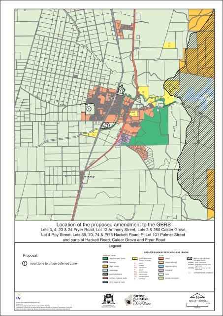
Location of the proposed <strong>amendment</strong> to the GBRS<br />
Lots 3, 4, 23 & 24 Fryer Road, Lot 12 Anthony Street, Lots 3 & 250 Calder Grove,<br />
Lot 4 Roy Street, Lots 69, 70, 74 & Pt75 Hackett Road, Pt Lot 101 Palmer Street<br />
and parts of Hackett Road, Calder Grove and Fryer Road<br />
Legend<br />
Proposal:<br />
1 rural zone to urban deferred zone<br />
Reserved Lands<br />
regional open space<br />
r<strong>ai</strong>lways<br />
state forests<br />
waterways<br />
port installations<br />
primary regional roads<br />
A<br />
H<br />
HS<br />
P<br />
PU<br />
SU<br />
TS<br />
U<br />
GREATER BUNBURY REGION SCHEME LEGEND<br />
public purposes -<br />
denoted as follows :<br />
<strong>ai</strong>rport<br />
hospital<br />
high school<br />
prison<br />
public utilities<br />
special uses<br />
technical school<br />
university<br />
Zones<br />
urban<br />
urban deferred<br />
regional centre<br />
industrial<br />
rural<br />
private recreation<br />
special control areas<br />
denoted as follows :<br />
SCA NO.1 water catchments<br />
SCA NO.2 Kemerton industrial zone<br />
buffer area<br />
SCA NO.3 Glen Iris service corridor<br />
buffer area<br />
EC<br />
environmental conditions<br />
other regional roads<br />
harvey urban deferred location plan.dgn<br />
06 Apr 2011<br />
Produced by Cartographic Section, South West <strong>Planning</strong><br />
Department of <strong>Planning</strong>, on behalf of the <strong>Western</strong> <strong>Australian</strong> <strong>Planning</strong> Commission, Perth WA<br />
Base information supplied by <strong>Western</strong> <strong>Australian</strong> Land Information Authority LI430-2009-4.<br />
0<br />
N<br />
SCALE 1:50000<br />
1000<br />
metres


