Pinellas - Rails-to-Trails Conservancy
Pinellas - Rails-to-Trails Conservancy
Pinellas - Rails-to-Trails Conservancy

Create successful ePaper yourself
Turn your PDF publications into a flip-book with our unique Google optimized e-Paper software.
LAKE<br />
<strong>Pinellas</strong><br />
Trail<br />
Loop<br />
Plan<br />
A Case Study<br />
November 2008<br />
(An Extension of the Existing <strong>Pinellas</strong> Trail <strong>to</strong><br />
Form a Loop Through the Entire County<br />
Connecting All Major Destinations)<br />
Brian K. Smith<br />
Executive Direc<strong>to</strong>r<br />
<strong>Pinellas</strong> County<br />
Metropolitan Planning Organization<br />
600 Cleveland Street, Suite 750<br />
Clearwater, FL 33755<br />
727-464-8200<br />
fax: 727-464-8201<br />
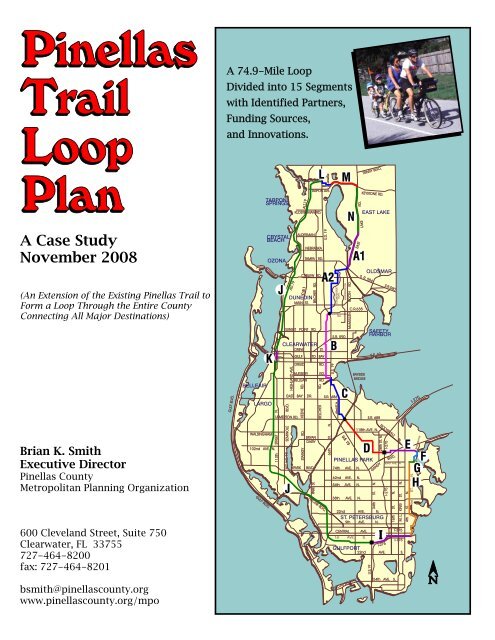
A 74.9-Mile Loop<br />
Divided in<strong>to</strong> 15 Segments<br />
with Identified Partners,<br />
Funding Sources,<br />
and Innovations.<br />
GULF BLVD.<br />
BELLEAIR<br />
LARGO<br />
WALSINGHAM<br />
102nd AVE. N.<br />
GULF BLVD.<br />
TARPON<br />
SPRINGS<br />
CRYSTAL<br />
BEACH<br />
OZONA<br />
K<br />
EAST AVE.<br />
113th STREET N.<br />
J<br />
SUNSET POINT RD.<br />
CLEARWATER<br />
DREW ST.<br />
SEMINOLE BLVD.<br />
ULMERTON RD.<br />
ALT. U.S. 19<br />
ALT.19<br />
GULF<br />
BELLEAIR<br />
PARK<br />
ALT.19<br />
ALDERMAN<br />
CURLEW RD.<br />
C.R.1<br />
DUNEDIN<br />
MAIN ST.<br />
KEENE RD.<br />
EAST BAY<br />
J<br />
HIGHLAND AVE.<br />
DRUID<br />
NURSERY<br />
STARKEY RD.<br />
DR.<br />
BELCHER RD.<br />
BRYAN<br />
DAIRY<br />
BLVD.<br />
TARPON AVE.<br />
KLOSTERMAN RD.<br />
TO BAY<br />
PARK ST.<br />
L<br />
NEBRASKA<br />
TAMPA RD.<br />
RD.<br />
RD.<br />
RD.<br />
BELCHER<br />
RD.<br />
TYRONE BLVD.<br />
U.S. 19<br />
JASMINE<br />
MELON<br />
A2<br />
S.R. 686<br />
66th ST. N.<br />
U.S. 19<br />
COUNTRYSIDE<br />
BLVD.<br />
S.R. 590<br />
62nd ST. N.<br />
LANDMARK DR.<br />
ENTERPRISE<br />
RD.<br />
B<br />
M<br />
C<br />
U.S. 19<br />
McMULLEN BOOTH RD.<br />
62nd AVE. N.<br />
54th AVE. N.<br />
38th AVE. N.<br />
TRINITY BLVD.<br />
GANDY<br />
34th ST. N.<br />
22nd AVE. N.<br />
ST. PETERSBURG<br />
9th AVE. N.<br />
CENTRAL<br />
N<br />
EAST<br />
RD.<br />
A1<br />
C.R.638<br />
S. R. 584<br />
BAYSIDE<br />
BRIDGE<br />
74th AVE. N.<br />
KEYSTONE RD.<br />
AVE.<br />
1st AVE. S.<br />
EAST LAKE<br />
S.R. 60<br />
S.R. 688<br />
118th AVE. N.<br />
PINELLAS PARK<br />
OLDSMAR<br />
U.S.19<br />
S.R.580<br />
SAFETY<br />
HARBOR<br />
ROOSEVELT BL.<br />
28th ST. N.<br />
I-275<br />
I-275<br />
I-275<br />
BLVD.<br />
16th ST. N.<br />
M. L. KING ST. N.<br />
I-375<br />
I-175<br />
GULFPORT<br />
22nd AVE. S.<br />
4th ST. N.<br />
1st ST. N.<br />
I-275<br />
D E<br />
F<br />
G<br />
83RD AVE. N.<br />
H<br />
I<br />
SAN MARTIN<br />
bsmith@pinellascounty.org<br />
www.pinellascounty.org/mpo<br />
PINELLAS BAYWAY<br />
54th AVE. S.
PINELLAS TRAIL LOOP PLAN -- A CASE STUDY<br />
The <strong>Pinellas</strong> Trail was originated in 1990 and by 1992 connected the St. Petersburg area along the western<br />
side of <strong>Pinellas</strong> County <strong>to</strong> Tarpon Springs. It was built on land that had been acquired from the railroad in<br />
the mid-1980s. This original section of the trail is 34 1/2 miles long. The trail is a 15-foot wide paved<br />
surface separated from mo<strong>to</strong>rized vehicles. It runs through the middle of the urban area and passes<br />
through six municipalities and several unincorporated communities. It connects the down<strong>to</strong>wn areas of<br />
these communities with residential areas, preserves, beaches, cultural facilities, parks, shopping, schools,<br />
and many other community destinations. In fact, the trail has become an influence on how development is<br />
occurring within the county. As an example, the city of Dunedin has <strong>to</strong>tally reoriented its down<strong>to</strong>wn <strong>to</strong>ward<br />
pedestrians such that it is focused around the trail which passes through the middle of the down<strong>to</strong>wn area.<br />
The Trail was originally conceived by the MPO’s Bicycle Advisory Committee as a recreation facility;<br />
however, not long after it was built residents and visi<strong>to</strong>rs began <strong>to</strong> use it as a transportation facility.<br />
Surveys of the trail use found that two-thirds of the trips on the trail are for work, school, errand running or<br />
social purposes. 80,000 people a month are found <strong>to</strong> be using the Trail. The original trail, in addition <strong>to</strong> the<br />
paved surface, contains three overpasses at Alt. U.S. 19, Bay Drive, and Ulmer<strong>to</strong>n Road. These<br />
overpasses were considered critical in making the initial trail a safe facility for people <strong>to</strong> use.<br />
Over the years, improvements have been made <strong>to</strong> the Trail, continually making it safer and more<br />
convenient <strong>to</strong> use. Six more overpasses were added across congested roadways. In addition, a half mile<br />
long trail bridge across Boca Ciega Bay was built where the original railroad trestle used <strong>to</strong> be. These latter<br />
improvements were funded from a combination of federal enhancement dollars and CMAQ dollars<br />
allocated by the MPO. This level of commitment was made <strong>to</strong> the Trail because it was now serving as a<br />
transportation service for both the residents and visi<strong>to</strong>rs <strong>to</strong> <strong>Pinellas</strong> County.<br />
As the <strong>Pinellas</strong> Trail established trails as a viable means of transportation, many communities became<br />
interested in developing trails connecting <strong>to</strong> the original corridor. The MPO's Bicycle Advisory Committee<br />
saw the need <strong>to</strong> document and plan these efforts in<strong>to</strong> one cohesive program. The Committee met with<br />
every jurisdiction in the county that had responsibility for constructing such facilities. Based upon that<br />
effort, a Trailways Plan was developed containing over 200 miles of trails within the urban area. These<br />
trails were all practical projects which had community support. The trails formed a complete system of<br />
connectivity within the county.<br />
During this process, the Committee identified a 20-mile long power line corridor along the east side of the<br />
county parallel <strong>to</strong> the existing <strong>Pinellas</strong> Trail. The Committee worked with the county and MPO <strong>to</strong> negotiate<br />
the use of that corridor, which was at the time controlled by Florida Power, for the purpose of a multiuse<br />
trail. The negotiations were successful and the power company provided a 99-year lease <strong>to</strong> the county for<br />
the construction of the trail. In return, the power company was given naming rights <strong>to</strong> call the trail the<br />
Florida Power Trail. Florida Power became Progress Energy and the project has continued on. The first<br />
segment of this trail has now been built and is in use.
It should be noted there is a benefit <strong>to</strong> have an existing trail such as the <strong>Pinellas</strong> Trail established within the<br />
community already because, as new trails are proposed, there is a higher comfort level in the community of<br />
what <strong>to</strong> expect when the trail is built. In that context, the MPO hosts a Trail Security Task Force consisting<br />
of all the law enforcement agencies along the existing corridor who meet quarterly for coordination and<br />
exchange of information. In addition, the MPO performed a study of real estate value and how that has<br />
positively affected the properties along the existing trail.<br />
In late 2006, the Bicycle Advisory Committee realized the Trailways Plan needed <strong>to</strong> be better defined, with<br />
an emphasis placed upon a continuous trail looping through the county serving as a main connecting line<br />
for the entire system. The result of this effort was a corridor referred <strong>to</strong> as the <strong>Pinellas</strong> Trail Loop. This<br />
included the existing <strong>Pinellas</strong> Trail, with improvements on the west side of the county and the Progress<br />
Energy Trail on the east side of the county. This loop is 74-miles long and connects all of the major<br />
destinations within the county. The loop also provides for regional connections <strong>to</strong> the adjacent counties.<br />
With some minor adjustments, the loop utilizes the facilities that already existed within the Trailways plan.<br />
When the Bicycle Advisory Committee first identified this trail loop plan, it appeared <strong>to</strong> be <strong>to</strong>o large an<br />
undertaking for the policy people <strong>to</strong> consider. The Committee carefully broke the entire loop plan in<strong>to</strong> 15<br />
manageable segments. Each of these segments was identified on a master map and then individually<br />
mapped. A master chart was developed keyed <strong>to</strong> this mapping which documented concerns and<br />
characteristics of each of those segments. This chart also includes partners that are involved, the activities<br />
<strong>to</strong> be undertaken, and the possible funding sources.<br />
Through this procedure, all of the key agencies developed a higher comfort level with the plan because it<br />
appeared <strong>to</strong> be manageable. The way this management plan is structured, there are activities furthering<br />
the various segments which are occurring at the same time. It should also be noted that with this approach<br />
and the various participants, creative ways are being identified <strong>to</strong> efficiently define and configure the Trail<br />
segments. This is resulting in considerable cost savings and also cost sharing among the segment<br />
partners. Using this approach, the Committee has set the goal of having this <strong>Pinellas</strong> Trail Loop plan built<br />
within 10 years. It should be noted that each segment sometimes has entirely different characteristics,<br />
partners, and funding sources. An example is the new segment of Trail that takes the <strong>Pinellas</strong> Trail in<strong>to</strong> the<br />
down<strong>to</strong>wn area of St. Petersburg. This effort involved the Trust for Public Land negotiating the purchase of<br />
this corridor from the railroad. While this was being negotiated, the County held the corridor integrity<br />
constant with the exercise of the federal rail banking procedure. An earmark had been obtained through<br />
Congressman Bill Young's office <strong>to</strong> complete the purchase of the corridor. FDOT assisted with this<br />
transaction. The city of St. Petersburg then agreed <strong>to</strong> build the trail using grant funds. <strong>Pinellas</strong> County<br />
<strong>to</strong>ok action <strong>to</strong> provide transportation impact fees for the funding of the overpass <strong>to</strong> be built by the city on<br />
U.S. 19 <strong>to</strong> connect this section of trail <strong>to</strong> the existing trail.<br />
This Loop Plan can serve as a blueprint for other jurisdictions <strong>to</strong> follow since every possible scenario of a<br />
trail configuration is included within this plan. At the present time, not all the funding is identified that is<br />
necessary <strong>to</strong> complete this plan. To date, funding for this plan had been derived from the local<br />
infrastructure sales tax, MPO federal enhancement funds, transportation impact fees, federal earmark,<br />
financial assistance from the Trust for Public Land Inc., developer contributions, and MPO federal CMAQ<br />
funding.<br />
-2-
BELCHE R RD<br />
N B<br />
D R<br />
LANDMARK DR.<br />
COUNTRYSIDE BLVD.<br />
<strong>Pinellas</strong><br />
Trail Loop<br />
US US US US US HIGHWAY HIGHWAY HIGHWAY HIGHWAY HIGHWAY 19 19 19 19 19 N N N N N<br />
US 19 UNDERPASS<br />
JASMINE<br />
MELON<br />
COACHMAN PARK<br />
MEMORIAL CSWY<br />
L<br />
FUTURE<br />
BEACH TRAIL<br />
INTERCONNECT<br />
34TH ST N<br />
55<br />
34TH ST S<br />
5TH AVE N<br />
GANDY BLVD.<br />
I-275<br />
CENTRAL AVE<br />
22nd AVE. N.<br />
28TH ST N<br />
US 19 OVERPASS<br />
54th AVE. N.<br />
38th AVE. N.<br />
30th AVE. N.<br />
9th AVE. N.<br />
5TH AVE N<br />
5th AVE. N.<br />
I-375<br />
CENTRAL AVE<br />
I<br />
I-275<br />
83rd AVE. N.<br />
77th AVE. N.<br />
DR. MARTIN LUTHER KING JR. ST. N.<br />
TARPON SPRINGS<br />
CITY PARK<br />
LAKE TARPON<br />
4th STREET N.<br />
A19<br />
1st STREET N.<br />
H<br />
EAST AVENUE<br />
TURNER ST.<br />
K<br />
S MYRTLE AVE<br />
SAN MARTIN<br />
62nd AVE. N.<br />
M<br />
KEYSTONE RD<br />
KEYSTONE ROAD<br />
5TH AVE N<br />
CENTRAL AVE<br />
I-175<br />
1st AVE S<br />
TROPICANA FIELD<br />
DREW ST<br />
DR DR DR DR DR MARTIN MARTIN MARTIN MARTIN MARTIN LUTHER LUTHER LUTHER LUTHER LUTHER KING KING KING KING KING JR JR JR JR JR ST ST ST ST ST N N N N N<br />
I-175<br />
DR DR DR DR DR MARTIN MARTIN MARTIN MARTIN MARTIN LUTHER LUTHER LUTHER LUTHER LUTHER KING KING KING KING KING JR JR JR JR JR ST ST ST ST ST S S S S S<br />
AT GRADE CROSSING<br />
CLEVELAND ST<br />
COURT ST<br />
5TH AVE N<br />
CENTRAL AVE<br />
WEEDON<br />
ISLAND<br />
PRESERVE<br />
4TH ST N<br />
687<br />
4TH ST S<br />
651<br />
CENTRAL AVE<br />
92<br />
Trail<br />
TAMPA BAY<br />
EAST EAST EAST EAST EAST LAKE LAKE LAKE LAKE LAKE RD RD RD RD RD<br />
590<br />
1st STREET<br />
Sidepath<br />
GULF BLVD.<br />
BELLEAIR<br />
LARGO<br />
WALSINGHAM<br />
102nd AVE. N.<br />
GULF BLVD.<br />
TARPON<br />
SPRINGS<br />
CRYSTAL<br />
BEACH<br />
OZONA<br />
K<br />
EAST AVE.<br />
113th STREET N.<br />
J<br />
SUNSET POINT RD.<br />
SEMINOLE BLVD.<br />
ULMERTON RD.<br />
ALT. U.S. 19<br />
ALT.19<br />
GULF<br />
PARK<br />
ALT.19<br />
ALDERMAN<br />
DREW<br />
BELLEAIR<br />
CURLEW RD.<br />
C.R.1<br />
DUNEDIN<br />
HIGHLAND AVE.<br />
MAIN ST.<br />
DRUID<br />
NURSERY<br />
KEENE RD.<br />
EAST BAY<br />
STARKEY RD.<br />
DR.<br />
BELCHER RD.<br />
BRYAN<br />
DAIRY<br />
BLVD.<br />
TARPON AVE.<br />
NEBRASKA<br />
TAMPA RD.<br />
CLEARWATER<br />
J<br />
KLOSTERMAN RD.<br />
TO BAY<br />
PARK ST.<br />
L<br />
ST.<br />
RD.<br />
RD.<br />
RD.<br />
BELCHER<br />
RD.<br />
TYRONE BLVD.<br />
U.S. 19<br />
JASMINE<br />
MELON<br />
A2<br />
S.R. 686<br />
66th ST. N.<br />
U.S. 19<br />
COUNTRYSIDE<br />
BLVD.<br />
S.R. 590<br />
62nd ST. N.<br />
LANDMARK DR.<br />
ENTERPRISE<br />
RD.<br />
B<br />
M<br />
C<br />
U.S. 19<br />
McMULLEN BOOTH RD.<br />
62nd AVE. N.<br />
54th AVE. N.<br />
38th AVE. N.<br />
TRINITY BLVD.<br />
GANDY<br />
34th ST. N.<br />
22nd AVE. N.<br />
CENTRAL<br />
N<br />
EAST<br />
C.R.638<br />
PINELLAS BAYWAY<br />
RD.<br />
S. R. 584<br />
BAYSIDE<br />
BRIDGE<br />
74th AVE. N.<br />
LAKE<br />
A1<br />
KEYSTONE RD.<br />
9th AVE. N.<br />
AVE.<br />
1st AVE. S.<br />
EAST LAKE<br />
S.R. 60<br />
S.R. 688<br />
118th AVE. N.<br />
PINELLAS PARK<br />
U.S.19<br />
S.R.580<br />
SAFETY<br />
HARBOR<br />
ROOSEVELT BL.<br />
28th ST. N.<br />
ST. PETERSBURG<br />
GULFPORT<br />
OLDSMAR<br />
I-275<br />
I-275<br />
I-275<br />
BLVD.<br />
83RD AVE. N.<br />
16th ST. N.<br />
54th AVE. S.<br />
M. L. KING ST. N.<br />
I-375<br />
I-175<br />
22nd AVE. S.<br />
4th ST. N.<br />
1st ST. N.<br />
I-275<br />
D E<br />
F<br />
G<br />
I<br />
SAN MARTIN<br />
H<br />
10/16/08<br />
CURLEW RD<br />
A2<br />
KEENE RD. CR 1<br />
NURSERY RD.<br />
BELLEAIR RD.<br />
BELCHER RD<br />
ELCHER RD<br />
MAIN ST SR 580<br />
SR580<br />
SUNSET POINT RD.<br />
DREW ST.<br />
COUNTRYSIDE BLVD<br />
HERCULES RD.<br />
H AY 19 N<br />
US HIG W<br />
TARPON OUTFALL CANAL<br />
DRUID RD.<br />
NURSERY RD.<br />
BELCHER RD.<br />
BELLEAIR RD.<br />
US HIGHWAY 19 N<br />
LAKE TARPON<br />
586<br />
CURLEW RD<br />
US HIGHWAY 19 N<br />
BOOT<br />
RANCH<br />
BLVD. N.<br />
TAMPA ROAD<br />
FDOT OVERPASS<br />
US 19<br />
SR 580<br />
REAM WILSON TRAIL<br />
CONNECTION<br />
GULF TO BAY BLVD. SR 60<br />
LAKE ST GEORGE<br />
CHESNUT<br />
PARK<br />
ENTRANCE<br />
OLDSMAR<br />
TRAIL<br />
CONNECTION<br />
ENTERPRISE RD.<br />
US 19<br />
EAST LAKE ROAD<br />
WOODLANDS BLVD.<br />
A1<br />
MCM ULLEN BOOTH RD<br />
B<br />
SR 590<br />
TAMPA BAY<br />
MCMULLEN BOOTH RD<br />
CURLEW RD<br />
ENTERPRISE RD.<br />
McMULLEN BOOTH RD.<br />
SR 580<br />
AT GRADE<br />
CROSSING<br />
TA MPA RD<br />
Progress Energy<br />
Alignment<br />
ENTERPRISE RD E<br />
MAIN ST.<br />
BAYSIDE<br />
BRIDGE<br />
BAYSIDE<br />
BRIDGE<br />
580<br />
Countryside Blvd.<br />
Alignment<br />
Landmark Drive<br />
Alignment<br />
Composite Alignment<br />
CENTRAL AVENUE<br />
GANDY<br />
GANDY<br />
I-275<br />
DR DR DR DR DR MARTIN MARTIN MARTIN MARTIN MARTIN LUTHER LUTHER LUTHER LUTHER LUTHER KING KING KING KING KING JR JR JR JR JR ST ST ST ST ST N N N N N<br />
I-175<br />
RIO VISTA PARK<br />
4TH ST N<br />
687<br />
4TH 4TH 4TH 4TH 4TH ST ST ST ST ST N N N N N<br />
92<br />
83rd AVE. N.<br />
1st STREET N.<br />
SAN MARTIN BLVD.<br />
G<br />
H<br />
FBRIDGE<br />
T. E. Funded Project<br />
(77th Ave. N <strong>to</strong> 30th Ave. N.)<br />
Partial Funding<br />
(30th Ave. N. <strong>to</strong> 1st Ave. S.)<br />
RIO VISTA SCHOOL<br />
WEEDON<br />
ISLAND<br />
BRYAN DAIRY<br />
RD.<br />
Resource Recovery<br />
Facility<br />
D<br />
I-275<br />
Toy<strong>to</strong>wn<br />
Struthers<br />
Overpass<br />
GANDY BLVD.<br />
I-275<br />
DR. M. L. KING JR. ST. N<br />
ROOSEVELT BLVD.<br />
102nd AVE. N.<br />
E<br />
94th AVE. N.<br />
4th ST. N.<br />
GANDY BLVD. US 92<br />
Friendship Trail<br />
SAN MARTIN<br />
F<br />
Weedon<br />
Island<br />
58th ST. N.<br />
CROSS BAYOU<br />
ULMERTON RD. SR 688<br />
Underpass<br />
D<br />
US 19 N.<br />
49th ST. N.<br />
126th AVE. N.<br />
118th AVE. N.<br />
110th AVE. N.<br />
Drainageway<br />
County Utilities<br />
Corridor ROW<br />
Drainage Easement<br />
ROW<br />
County Utilites<br />
ROW<br />
34th ST. N.<br />
ROOSEVELT BLVD.<br />
28th ST. N.<br />
Resource<br />
Recovery<br />
Facility<br />
I-275<br />
Overpass<br />
GANDY BLVD.<br />
US 19<br />
HAINES BAYSHORE RD.<br />
WHITNEY RD.<br />
E. BAY DR. ROOSEVELT BLVD.<br />
150th AVE. N.<br />
66th ST. N.<br />
US 19<br />
62nd ST. N.<br />
C<br />
SR 686<br />
49th ST. N.<br />
FDOT<br />
UNDERPASS<br />
ULMERTON RD. SR 688<br />
P18/MPO/BKPD/Loop/Segments 6 10/17/08
A1 Chesnut<br />
A2 Progress Energy Trail<br />
B<br />
C<br />
D<br />
E<br />
F<br />
Progress Energy Trail<br />
DESCRIPTION MILES DIRECTION AND OPTIONS PARTICIPANTS<br />
West side of East Lake<br />
Road Chesnut Park <strong>to</strong><br />
Tampa Rd<br />
PE alignment<br />
Tampa Road <strong>to</strong> US 19<br />
PE alignment<br />
I-275 <strong>to</strong> Weedon<br />
G Rio Vista Rio Vista <strong>to</strong> 1st Street 0.5<br />
H<br />
I<br />
J<br />
K<br />
L<br />
M<br />
N<br />
PROJECT NAME<br />
Progress Energy Trail<br />
Progress Energy Trail<br />
Progress Energy Trail<br />
83rd Connec<strong>to</strong>r<br />
North Bay<br />
CSX<br />
Fred Marquis<br />
East Avenue<br />
Jasmine /Melon<br />
Keys<strong>to</strong>ne<br />
East Lake Rd<br />
PE alignment<br />
US 19 <strong>to</strong> US 19<br />
PE alignment<br />
US 19 <strong>to</strong> Ulmer<strong>to</strong>n<br />
PE alignment<br />
Ulmer<strong>to</strong>n <strong>to</strong> I-275<br />
1st Street & Coffee Pot Blvd.<br />
Rio Vista <strong>to</strong> 1st Ave S<br />
Tarpon Springs <strong>to</strong> St. Pete<br />
US 19 <strong>to</strong> US 19<br />
Clearwater Down<strong>to</strong>wn<br />
Segment<br />
O LOOP Entire Trail<br />
83rd Ave. alignment<br />
San Martin <strong>to</strong> Rio Vista<br />
1st Avenue South and CSX<br />
Water Front <strong>to</strong> US 19<br />
Live Oak - Jasmine-Melon<br />
US 19 <strong>to</strong> Keys<strong>to</strong>ne Rd.<br />
North side of Keys<strong>to</strong>ne Rd<br />
Melon St <strong>to</strong> East Lake Rd<br />
West side of East Lake Rd.<br />
Keys<strong>to</strong>ne <strong>to</strong> Chesnut Park<br />
1.8<br />
4.5<br />
5.5<br />
2.8<br />
5.3<br />
2.5<br />
0.9<br />
6.3<br />
3.0<br />
33.5<br />
East Lake Road corridor<br />
Consider sidewalk upgrade<br />
on service road<br />
3 other options are:<br />
- Countryside Blvd<br />
- Landmark Drive<br />
- Hybrid of Countryside/PE<br />
County<br />
Clearwater,<br />
County, PE<br />
2007 PROJECT<br />
COST EST.<br />
$ 10.7 M<br />
(cost will be reduced)<br />
$ 11.4 M<br />
(cost will be reduced)<br />
At-Grade Trail Penny F<br />
US 19/Enterprise<br />
Overpass<br />
FDOT<br />
F<br />
FOLLOW THROUGH<br />
Consider sidewalk upgrade on service road as a less costly alternative<br />
a) Refine Landmark Drive alternative<br />
b) Explore city constructing w/ city resources<br />
c) Pursue design/construction w/ Penny funds<br />
d) Eval recommended Hybrid PE corr w/Countryside Blvd<br />
Construction complete from Belleair Road <strong>to</strong> Bright House Field;<br />
Balance of project construction <strong>to</strong> Enterprise Rd <strong>to</strong> follow completion of first<br />
phase<br />
Construction of Overpass by FDOT underway<br />
cost: $3.9 M<br />
(need <strong>to</strong> track earmarked funds)<br />
TO BE FUNDED<br />
$ 10.7 M<br />
(cost will be reduced)<br />
$ 11.4 M<br />
(cost will be reduced)<br />
EVAL ESTIM $ 1.9 M<br />
US 19/Belleair<br />
Crossing<br />
FDOT F Incorporated as an at-grade crossing in US 19 Bayside Project<br />
Pursue at-grade Trail with Penny County, PE, Largo TBD<br />
$ 7.4 M Schedule design in 08/09 construction in 09/10 with Penny $ 7.4 M<br />
Ulmer<strong>to</strong>n underpass -<br />
FDOT under construction<br />
FDOT FDOT<br />
F Underpass construction included as part of Ulmer<strong>to</strong>n Road project Construction Complete<br />
Pursue PE alignment<br />
Negotiate developer construction<br />
Collaborate with St. Pete<br />
Pursue incorporation in Gandy<br />
Improvement with FDOT<br />
Pursue north side of 83rd Avenue<br />
Incorporate in bridge rehabilitation<br />
City constructed Trail<br />
Uses existing pedestrian bridge over<br />
canal<br />
City designing 1st St. off-road side path<br />
Work with City on seeking construction<br />
fund<br />
St. Pete constructing Coffee Pot<br />
area Trail<br />
Resurface existing Trail per<br />
Penny Program ($3M)<br />
6 Blks Upgrade 6-block section <strong>to</strong> Trail design<br />
0.8<br />
3.0<br />
4.3<br />
Total<br />
74.9<br />
Constructing with existing Penny funds:<br />
- Enterprise overpass - FDOT 2008<br />
- Belleair - US 19 crossing - FDOT 2009<br />
Continue PE alignment<br />
Negotiate with utilities alignment (1.8<br />
mi)<br />
Negotiate - developer construction<br />
Seek interstate funding for overpass<br />
City designing and constructing 12-foot<br />
trail on CSX and off-road side path<br />
on<br />
1st Avenue South<br />
U.S. 19 includes Trail underpass per<br />
MPO action<br />
County Constructed Trail segment<br />
Trail <strong>to</strong> be on north side with road<br />
improvement<br />
Keys<strong>to</strong>ne Road crossing at East Lake<br />
Road <strong>to</strong> be at-grade<br />
Trail exists as side path on west of<br />
roadway<br />
County, PE,<br />
Clearwater, FDOT<br />
County, St. Pete,<br />
<strong>Pinellas</strong> Park,<br />
Utilities, FDOT,<br />
PE, Developers<br />
County, St. Pete,<br />
FDOT, PE,<br />
Developers<br />
County, St. Pete<br />
$ 7.3 M<br />
(cost reduction w/<br />
partners including<br />
trail in their projects<br />
Negotiate with developers<br />
Collaborate with City<br />
Pursue with Gandy Improvements<br />
St. Pete, County Existing<br />
N/A Existing<br />
St. Pete, County<br />
St. Pete, County,<br />
FDOT<br />
County, FDOT<br />
Clearwater,<br />
County<br />
$ 5.7 M<br />
(cost will be reduced)<br />
County committing $2M <strong>to</strong> construct the 1st Street section of this trail;<br />
the city is funding the balance of the project <strong>to</strong> the south.<br />
Total trail cost will be much less than the original $5.7M<br />
$ 17.2 M<br />
(cost reduced w/ partnerships<br />
and partners building trail)<br />
$ 7.3 M<br />
(cost reduction w/ partners<br />
including trail in their projects<br />
$ 5.7 M<br />
(cost will be reduced)<br />
12-ft trail St. Petersburg $ 1.5 M /F Existing Grand Opening 10/04/08<br />
add ped trail<br />
(5-ft)<br />
TBD $ 1.5 M Work with St. Pete on funding $ 1.5 M<br />
US 19 Overpass<br />
Impact Fees<br />
$ 3 M<br />
(modified by MPO <strong>to</strong> $3.5M)<br />
N/A<br />
$1.2 M<br />
MPO recommended County fund - BCC funding with Impact Fees;<br />
Funding agreement in negotiation for construction.<br />
Advance funding from Penny Extension.<br />
BAC <strong>to</strong> recommend problem segments for rehab funding,<br />
but full rehab is necessary- enhancement funds also sought<br />
MPO placed high priority for Federal Enhancement funding - city initiating<br />
LAP agreement w/ FDOT<br />
County Existing<br />
N/A Existing<br />
County Road construction - Penny<br />
N/A Trail incorporated in road project <strong>to</strong> be constructed '09<br />
County Existing<br />
N/A Existing<br />
F = FUNDED<br />
TBD = TO BE DETERMINED<br />
FUNDING / SOURCE<br />
$ 17.2 M<br />
At-Grade Trail TBD<br />
(cost reduced w/<br />
partnerships and<br />
partners building<br />
trail)<br />
Negotiate with Utilities<br />
Negotiate with Developers<br />
Seek Federal funds for I-275 overpass<br />
Letter of Understanding with Lakes Homewoners Assoc. for Trail<br />
I-275 Overpass FDOT (TBD) $ 6.4 M $ 6.4 M<br />
TBD<br />
Bridge funding<br />
TBD<br />
TBD<br />
TBD<br />
TBD<br />
Existing<br />
TBD<br />
$ 8.5 M Evaluate funding options as part of bridge repair $ 8.5 M<br />
$ 3 M<br />
(modified by MPO <strong>to</strong> $3.5M)<br />
$ 1.2 M<br />
TOTAL<br />
$80.3 M<br />
(<strong>to</strong>tal cost will be reduced)<br />
Loop Chart 111208 11/14/2008
LAKE<br />
S.R.590<br />
HILLSBOROUGH CO.<br />
ELFERS TRAIL<br />
ELFERS SPUR-ANCLOTE CROSSING TRAIL<br />
HOWARD PARK TRAIL<br />
WHITCOMB BAYOU TRAIL<br />
MERES TRAIL<br />
TARPON SPRINGS<br />
PASCO<br />
ALT.19<br />
TARPON<br />
AVE.<br />
KLOSTERMAN<br />
RD.<br />
COUNTY<br />
RD.<br />
TRINITY BLVD.<br />
KEYSTONE RD.<br />
NORTHEAST EXTENSION-<br />
JASMINE SEGMENT<br />
STARKEY<br />
WILDERNESS TRAIL<br />
TRINITY TRAIL<br />
BROOKER CREEK TRAIL<br />
CRYSTAL BEACH<br />
ALDERMAN<br />
NEBRASKA<br />
U.S. 19<br />
EAST<br />
EAST LAKE<br />
NORTHEAST EXTENSION-<br />
KEYSTONE SEGMENT<br />
HONEYMOON ISLAND TRAIL<br />
CURLEW ROAD TRAIL<br />
DUNEDIN COMMUNITY TRAIL<br />
EDGEWATER TRAIL<br />
OLD COACHMAN TRAIL<br />
CSX TRAIL<br />
N. GREENWOOD LOOP<br />
MEMORIAL CAUSEWAY PATH<br />
CLEARWATER BEACH TRAIL<br />
EAST AVENUE CONNECTOR<br />
ROSS NORTON CONNECTION<br />
BELLEAIR ROAD TRAIL<br />
TAYLOR TRAIL<br />
BELLEAIR CAUSEWAY TRAIL<br />
LARGO BRICK TRAIL<br />
LARGO CENTRAL PARK TRAIL<br />
INDIAN ROCKS BRIDGE<br />
WALSINGHAM SPUR<br />
SEMINOLE SPC SPUR<br />
CULTURAL FACILITIES TRAIL<br />
PARK BLVD. BRIDGE<br />
LAKE SEMINOLE TRAIL<br />
GULF BEACHES BIKE PATH<br />
GULF BLVD.<br />
WELCH CAUSEWAY<br />
BELLEAIR<br />
LARGO<br />
WALSINGHAM<br />
RD.<br />
GULF BLVD.<br />
PINELLAS EQUESTRIAN TRAIL<br />
TREASURE ISLAND CAUSEWAY TRAIL<br />
PINELLAS<br />
TRAILWAYS PLAN<br />
PINELLAS TRAIL<br />
PINELLAS TRAIL<br />
EXTENSIONS<br />
COMMUNITY TRAILS<br />
GULF. BLVD.<br />
IMPROVEMENT PROGRAM<br />
PINELLAS TRAIL<br />
PROGRESS ENERGY EXT.<br />
BEACH ACCESS<br />
TO PINELLAS TRAIL<br />
Trail Overpass/Underpass<br />
<strong>Pinellas</strong> County MPO<br />
OZONA<br />
ALT. U.S. 19<br />
113th STREET N.<br />
102nd AVE. N.<br />
SEMINOLE<br />
ALT. U.S. 19<br />
ALT.19<br />
C.R.1<br />
DUNEDIN<br />
MAIN ST.<br />
SUNSET POINT RD.<br />
DREW<br />
GULF TO BAY<br />
DRUID<br />
NURSERY<br />
BELLEAIR<br />
KEENE RD.<br />
STARKEY RD.<br />
PARK<br />
TA MPA RD.<br />
CURLEW RD.<br />
RD.<br />
BRYAN<br />
DAIRY<br />
PARK ST.<br />
BELCHER RD.<br />
CLEARWATER<br />
EAST BAY DR.<br />
SEMINOLE BLVD.<br />
HIGHLAND AVE.<br />
BELCHER<br />
ULMERTON RD.<br />
37TH ST.<br />
TRAIL<br />
COREY<br />
CAUSEWAY<br />
SOUTH<br />
BEACHES<br />
TRAIL<br />
CHILDS PARK<br />
TRAIL<br />
(CLAM BAYOU)<br />
BAYWAY TRAIL<br />
SOUTH<br />
ST.<br />
BLVD.<br />
TYRONEBL.<br />
FORT DESOTO<br />
PARK TRAIL<br />
S.R. 580<br />
RD.<br />
RD.<br />
RD.<br />
SR 590<br />
66th ST. N.<br />
U.S. 19<br />
S.R. 686<br />
U.S. 19<br />
McMULLEN BOOTH RD.<br />
62nd AVE. N.<br />
54th AVE. N.<br />
38th AVE. N.<br />
GANDY<br />
34th ST. N.<br />
22nd AVE. N.<br />
9th AVE. N.<br />
CENTRAL<br />
BAYWAY<br />
C.R.752<br />
C.R.102<br />
BAYSIDE<br />
BRIDGE<br />
S.R. 60<br />
S.R. 688<br />
118th AVE. N.<br />
PINELLAS PARK<br />
74th AVE. N.<br />
OLDSMAR<br />
S.R.584 S.R. 580<br />
28th ST. N.<br />
ST. PETERSBURG<br />
5th AVE. N.<br />
SAFETY HARBOR<br />
AVE.<br />
I-275<br />
I-275<br />
22nd AVE. S.<br />
BAYSHORE TRAIL<br />
ROOSEVELT BL.<br />
I-275<br />
SKYWAY<br />
BRIDGE<br />
16th ST. N.<br />
54th AVE. S.<br />
M. L. KING ST. N.<br />
4th ST. N.<br />
LANDMARK TRAIL<br />
OLDSMAR/SAFETY HARBOR<br />
CROSSING TRAIL<br />
BAYSHORE TRAIL<br />
I-275<br />
OLDSMAR TRAILS<br />
ENTERPRISE TRAIL<br />
MAIN STREET TRAIL<br />
COURTNEY CAMPBELL<br />
RECREATIONAL TRAIL<br />
CLEARWATER EAST-WEST TRAIL<br />
COURTNEY CAMPBELL CONNECTION<br />
DRUID ROAD TRAIL<br />
142ND AVE. TRAIL<br />
BLV D.<br />
PINELLAS TRAIL<br />
EXTENSION<br />
(ST. PETERSBURG)<br />
BOOKER CREEK TRAIL<br />
DOWNTOWN CONNECTION<br />
TRAIL<br />
LAKE MAGGIORE TRAIL<br />
SOUTH BAY TRAIL<br />
BAYWAY TRAIL NORTH<br />
SKYWAY TRAIL<br />
GATEWAY<br />
NATURE TRAIL<br />
FRIENDSHIP TRAIL<br />
(Old Gandy bridge)<br />
WEEDON ISLAND<br />
TRAIL<br />
FREEDOM LAKE<br />
TRAIL<br />
NORTH BAY TRAIL<br />
(INCLUDES RIO VISTA<br />
CONNECTION)<br />
62ND AVE./JOE’S CREEK<br />
TRAIL<br />
NORTH BAY TRAIL<br />
P18/MPO/BKPD/Bmap1 10/24/07
THE PINELLAS TRAIL LOOP PROGRAM<br />
November 2008<br />
An oversight initiative by the Bicycle Advisory Committee (BAC) <strong>to</strong> assist the <strong>Pinellas</strong> County community in<br />
completing the loop within 10 years.<br />
A1. Chesnut Park Connec<strong>to</strong>r (1.8 miles) – Chesnut Park <strong>to</strong> Tampa Road<br />
The Trail is proposed <strong>to</strong> continue on the west side of East Lake Road and tie in<strong>to</strong> the extension of the<br />
Progress Energy Trail in the Tampa Road vicinity. The Trail will be located in the county road right-of-way<br />
but some alternatives will need <strong>to</strong> be explored <strong>to</strong> provide a good connection <strong>to</strong> the Trail <strong>to</strong> the south. This<br />
will be the same location where a connection will be made <strong>to</strong> the Oldsmar Trail, which opens regional<br />
connectivity <strong>to</strong> the east.<br />
A2. Progress Energy Trail Segment A (4.5 miles) –Tampa Road <strong>to</strong> Enterprise Road/U.S. 19<br />
The original alignment follows the powerline. Since large sections are not owned by the power company<br />
but have been permitted for various uses through easements, it is indicated that it could be very expensive<br />
<strong>to</strong> place a trail on the original alignment. The city of Clearwater has proposed two parallel north-south<br />
public right-of-way as available alternatives. These are Countryside Boulevard and Landmark Drive.<br />
These alignments have very wide public right-of-way with almost no driveway crossings, and actually have<br />
been considered by the city for years as candidates for a trail project. Discussion and coordination with the<br />
City <strong>to</strong> pursue one or both of these alternatives continues <strong>to</strong> be appropriate.<br />
A third alternative was identified that could use the Progress Energy corridor along the south end of the<br />
segment, then cross at Meadow Wood Drive <strong>to</strong> connect <strong>to</strong> Countryside Boulevard which would then used<br />
for the north segment of the trail. This alternative eliminates the need <strong>to</strong> pass though the privately owned<br />
segment <strong>to</strong> the north of the Progress Energy corridor that was identified <strong>to</strong> have high right-of-way costs.<br />
BAC asked the MPO <strong>to</strong> conduct a feasibility study <strong>to</strong> identify the most cost-effective alternative route<br />
possible <strong>to</strong> provide a connection through this area while still maintaining valuable connections <strong>to</strong> retail<br />
centers, public services, and other community destinations.<br />
B. Progress Energy Trail Segment B (5.5 miles) – Enterprise Road/U.S. 19 <strong>to</strong> Belleair Road/U.S. 19<br />
The Trail overpass of U.S. 19 at Enterprise Road is an FDOT project scheduled for construction in 2008.<br />
Utilizing Penny funding, Progress Energy has constructed the Trail in the powerline alignment from Belleair<br />
Road <strong>to</strong> Bright House Field north of Drew Street. The full contract provides for further construction<br />
northward <strong>to</strong> Enterprise Road and other areas <strong>to</strong> the south as funding permits. Engineering design for the<br />
section north of Bright House Field <strong>to</strong> the Enterprise Road interchange is nearly complete. The FDOT<br />
design for Belleair Road/U.S. 19 provides an at-grade crossing for the Trail. This is a FDOT funded project.<br />
North of Drew Street, the powerline corridor intersects with the CSX railroad, and this crossing provides an<br />
additional challenge. One alternative is <strong>to</strong> utilize the existing crossing of the railroad at the Ream Wilson<br />
Trail, Clearwater’s east-west multi-use trail. The proposed alignment would therefore follow the Ream<br />
Wilson Trail north of Bright House Field, <strong>to</strong> Old Coachman/NE Coachman intersection, where it would cross<br />
the railroad tracks. The sidewalk on NE Coachman will be widened from the railroad eastward <strong>to</strong> the<br />
powerline ROW, where the trail will continue north within the utility corridor.<br />
1
C. Progress Energy Trail Segment C (2.8 miles) – Belleair Road/US 19 <strong>to</strong> Ulmer<strong>to</strong>n Road<br />
The Trail proceeds from the east side of U.S.19 within the powerline alignment <strong>to</strong> Ulmer<strong>to</strong>n Road. It is<br />
anticipated that partial funding should be available <strong>to</strong> begin construction of Segment C and continue the<br />
Progress Energy Trail southward <strong>to</strong>ward Ulmer<strong>to</strong>n Road, where FDOT is currently constructing an<br />
underpass at Cross Bayou as part of the road construction project. The road construction and underpass is<br />
funded FDOT as part of Ulmer<strong>to</strong>n Road improvements scheduled for 2008.<br />
D. Progress Energy Trail Segment D (5.3 miles) – Ulmer<strong>to</strong>n Road <strong>to</strong> I-275<br />
The Trail through this segment for large sections does not follow the powerline alignment and diverts<br />
around the Mainland's area utilizing a county drainageway corridor and also a County Utilities property<br />
corridor. As the Trail crosses 28th Street, there are negotiations by the city of St. Petersburg for the Trail <strong>to</strong><br />
be built by developer Grady Pridgeon through this area <strong>to</strong> I-275. The crossing of I-275 will require an<br />
overpass, which will more than likely qualify for federal funding.<br />
E. Progress Energy Trail Segment E (2.5 miles) – I-275 <strong>to</strong>/Weedon Island Preserve and the Connection <strong>to</strong> the<br />
Friendship Trail<br />
The Trail follows the powerline alignment and there are many opportunities for partnerships <strong>to</strong> build the<br />
Trail with developers through this area. This will involve cooperation between <strong>Pinellas</strong> County, the city of<br />
St. Petersburg, Progress Energy and the several developers in the corridor. The Trail will also benefit from<br />
funding opportunities as it proceeds through the Gandy highway improvement projects.<br />
(The above segments A. through E. <strong>to</strong>tal 20.6 miles)<br />
F. 83rd Avenue Connec<strong>to</strong>r Trail (0.9 miles) – San Martin/Weedon Island <strong>to</strong> Rio Vista Drive<br />
The Trail proceeds along San Martin as it crosses the bridge and proceeds along 83rd Avenue <strong>to</strong> the<br />
school at Rio Vista. The Trail will follow the public right-of-way for this county road along the north side in<br />
this area. This segment will require a bridge crossing, but that can be incorporated in<strong>to</strong> the highway bridge<br />
improvement that is much needed at the same location. This will involve cooperation between the city of<br />
St. Petersburg and <strong>Pinellas</strong> County.<br />
G. Rio Vista Trail (0.5 miles) – 83rd Avenue <strong>to</strong> 1st Street<br />
The Trail proceeds along Rio Vista Drive <strong>to</strong> the city park and then follows the berm on the north side of the<br />
canal <strong>to</strong> the pedestrian bridge then over the canal <strong>to</strong> 1st Street. This project would incorporate and amplify<br />
a significant school crossing at Rio Vista at 83rd Avenue and be incorporated in<strong>to</strong> a city park. It would<br />
provide the opportunity for support facilities and parking for the Trail. A significant portion of this Trail has<br />
already been constructed by the city of St. Petersburg.<br />
H. North Bay Trail (6.3 miles) – Rio Vista Park <strong>to</strong> 1st Avenue South<br />
The Trail proceeds along the public right-of-way of 1st Street. This project will involve a modification of the<br />
four-lane roadway for inclusion of a separated bike path. In the vicinity of 22nd Avenue, the Trail will<br />
proceed through the Coffee Pot Bayou neighborhood and park in<strong>to</strong> the down<strong>to</strong>wn area of St. Petersburg.<br />
The Trail is within City public right-of-way for its entire length. The City is proceeding with the design of this<br />
Trail and has some partial funding for it.<br />
2
I. Down<strong>to</strong>wn Connection Trail (1.9 miles) – 1st St. <strong>to</strong> US 19/ 34th Street<br />
The Trail will first follow 1st Avenue South where a separated bikeway will be constructed along the south<br />
side. At 16th Street, the Trail will follow the CSX newly acquired corridor <strong>to</strong> U.S. 19. The city of St.<br />
Petersburg is actively pursuing the design and construction of this Trail with a 12 foot pathway be followed<br />
by a 5 foot pedestrian way when funds are available -- the existing school overpass for US 19 will be<br />
utilized <strong>to</strong> connect <strong>to</strong> the existing <strong>Pinellas</strong> Trail until funding can be obtained for a Trail overpass.<br />
J. Fred Marquis <strong>Pinellas</strong> Trail (34.5 miles) – U.S.19/34th Street <strong>to</strong> U.S. 19/Anclote River<br />
This is the original section of the <strong>Pinellas</strong> Trail which was constructed by <strong>Pinellas</strong> County in the early 1990s<br />
using the funding source of the Penny for <strong>Pinellas</strong>. The MPO has allocated significant federal funding for<br />
overpasses of major roads and for the Long Bayou crossing that connected St. Petersburg <strong>to</strong> Seminole.<br />
On the north at the Anclote River, the U.S. 19 improvement of several years ago incorporated an<br />
underpass for the <strong>Pinellas</strong> Trail providing the opportunity for the Trail <strong>to</strong> continue east<br />
K. East Avenue Upgrade <strong>to</strong> the <strong>Pinellas</strong> Trail (6 blocks) – Druid Road <strong>to</strong> Drew Street<br />
The current <strong>Pinellas</strong> Trail follows East Avenue on the east side as a wide sidewalk. The plan calls for<br />
conversion of this segment <strong>to</strong> be built like the other Trail areas. This is an active rail line area. The<br />
southbound lane of the road would be eliminated and the Trail would be expanded in<strong>to</strong> that area with<br />
adequate buffering <strong>to</strong> the rail line, while also providing for landscape opportunities. This project would also<br />
be important in that it would serve as an extension of the new city streetscape program on Cleveland Street<br />
in down<strong>to</strong>wn Clearwater.<br />
L. Jasmine/Melon Street Segment 0.8 miles) – U.S. 19 <strong>to</strong> Keys<strong>to</strong>ne Road<br />
The Trail proceeds from the underpass at U.S. 19 and follows public rights-of-way <strong>to</strong> Keys<strong>to</strong>ne Road. This<br />
segment has been recently constructed by <strong>Pinellas</strong> County. The Trail follows the Live Oak right-of-way <strong>to</strong><br />
Jasmine and proceeds on a separate pathway off that road <strong>to</strong> Melon, then proceeds on a separate pathway<br />
on that corridor <strong>to</strong> terminate on the north side of Keys<strong>to</strong>ne Road.<br />
M. Keys<strong>to</strong>ne Road Segment (3.0 miles) – Tarpon Springs City Park <strong>to</strong> East Lake Road<br />
The Trail is <strong>to</strong> be built as part of the Keys<strong>to</strong>ne Road highway improvement. That project is currently funded<br />
by <strong>Pinellas</strong> County and the design is being reconfigured based on recent cost increase issues. The Trail<br />
will be a separated pathway and is anticipated <strong>to</strong> be on the north side of the road. The segment will begin<br />
at Melon Street and will terminate on the west side of the intersection with East Lake Road. The Trail will<br />
use the signalized crossing <strong>to</strong> connect <strong>to</strong> the existing <strong>Pinellas</strong> Trail <strong>to</strong> the south.<br />
N. East Lake Road Segment (4.8 miles) – Keys<strong>to</strong>ne Road <strong>to</strong> Chesnut Park<br />
The Trail is a separate pathway and is an existing facility located on the west side of East Lake Road for its<br />
length. The Trail passes the entrance <strong>to</strong> Chesnut Park and terminates at the bridge for Brooker Creek.<br />
The <strong>to</strong>tal <strong>Pinellas</strong> Trail Loop mileage is 74.9 miles.<br />
3