

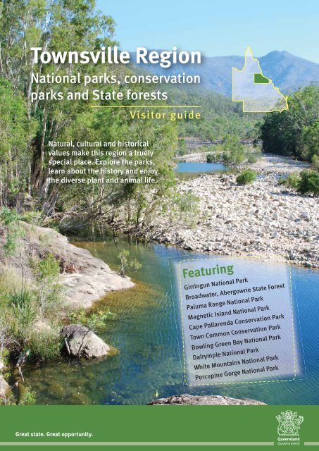
Townsville Region National parks, conservation parks and State ...
Townsville Region National parks, conservation parks and State ...
Townsville Region National parks, conservation parks and State ...

Create successful ePaper yourself
Turn your PDF publications into a flip-book with our unique Google optimized e-Paper software.
<strong>Townsville</strong> <strong>Region</strong><br />
<strong>National</strong> <strong>parks</strong>, <strong>conservation</strong><br />
<strong>parks</strong> <strong>and</strong> <strong>State</strong> forests<br />
Visitor guide<br />
Natural, cultural <strong>and</strong> historical<br />
values make this region a truely<br />
special place. Explore the <strong>parks</strong>,<br />
learn about the history <strong>and</strong> enjoy<br />
the diverse plant <strong>and</strong> animal life.<br />
Featuring<br />
Girringun <strong>National</strong> Park<br />
Broadwater, Abergowrie <strong>State</strong> Forest<br />
Paluma Range <strong>National</strong> Park<br />
Magnetic Isl<strong>and</strong> <strong>National</strong> Park<br />
Cape Pallarenda Conservation Park<br />
Town Common Conservation Park<br />
Bowling Green Bay <strong>National</strong> Park<br />
Dalrymple <strong>National</strong> Park<br />
White Mountains <strong>National</strong> Park<br />
Porcupine Gorge <strong>National</strong> Park<br />
Great state. Great opportunity.
Great Barrier Reef World Heritage Area<br />
<strong>Townsville</strong> regional map<br />
In 1981, the Great Barrier Reef <strong>and</strong><br />
isl<strong>and</strong>s became Queensl<strong>and</strong>’s first World<br />
Heritage area. Stretching more than 2000<br />
km along the Queensl<strong>and</strong> coastline <strong>and</strong><br />
covering 35 million hectares, the Great<br />
Barrier Reef is the world’s largest, <strong>and</strong><br />
probably richest, coral reef. It is home<br />
to more than 1500 species of fish, 4000<br />
species of molluscs, 400 species of<br />
sponge <strong>and</strong> 300 species of hard corals.<br />
2 2<br />
Extensive seagrass beds provide a<br />
home for the threatened dugong.<br />
Threatened green <strong>and</strong> loggerhead<br />
turtles nest on the beaches, <strong>and</strong><br />
humpback whales migrate to<br />
the area to give birth. Birdlife is<br />
abundant <strong>and</strong> hundreds of species<br />
nest on the reef isl<strong>and</strong>s <strong>and</strong><br />
mainl<strong>and</strong> beaches.<br />
The Great Barrier Reef is jointly managed by ‣<br />
the Queensl<strong>and</strong> <strong>and</strong> Australian governments.
Wet Tropics<br />
World Heritage Area<br />
Wallaman Falls, Broadwater Creek,<br />
Paluma Range <strong>National</strong> Park <strong>and</strong> the<br />
Dalrymple Gap track are all part of<br />
the Wet Tropics World Heritage Area<br />
(WTWHA). Declared in 1988, the WTWHA<br />
covers 8990 km 2 between <strong>Townsville</strong> <strong>and</strong><br />
Cooktown. It contains many outst<strong>and</strong>ing<br />
natural values, including some of the<br />
oldest, continuously surviving rainforests<br />
on earth, many rare <strong>and</strong> endangered<br />
plants <strong>and</strong> animals, <strong>and</strong> areas of<br />
spectacular beauty.<br />
Plants <strong>and</strong> animals<br />
The range of habitats provide homes for<br />
a rich variety of animals, one of the<br />
highest number in Australia. All of<br />
Australia’s six glider species, including<br />
the endangered mahogany glider, are<br />
found in the WTWHA. Platypus, eastern<br />
water dragons <strong>and</strong> freshwater turtles can<br />
be seen in the creeks <strong>and</strong> rivers.<br />
The rainforests are home to the<br />
endangered southern cassowary <strong>and</strong><br />
unique musky rat-kangaroo.<br />
The rainforest is often shrouded in mist.<br />
Photo: Tourism Queensl<strong>and</strong>.<br />
Wallaman Falls. ‣<br />
Tropical savannas<br />
Tropical savannas stretch across northern<br />
Australia from Broome to <strong>Townsville</strong>.<br />
The l<strong>and</strong>scapes have scattered trees <strong>and</strong><br />
dense grasses that flourish during the wet<br />
season <strong>and</strong> dry out during the long dry<br />
season. Fire is a frequent <strong>and</strong> important<br />
event in the savanna l<strong>and</strong>scape.<br />
Patches of dry rainforest, called vinethickets,<br />
often flourish in protected gullies.<br />
Plants <strong>and</strong> animals<br />
Native mammals are common but<br />
discreet as most are nocturnal, sheltering<br />
under vegetation or in burrows during the<br />
day <strong>and</strong> searching for herbs, grass <strong>and</strong><br />
fruit at night. Spectacled hare-wallabies<br />
live in the hummock grassl<strong>and</strong>s in open<br />
woodl<strong>and</strong>. They can be identified by<br />
a rufous-brown ring around each eye.<br />
Rufous bettongs emerge at night <strong>and</strong><br />
allied rock wallabies, wallaroos <strong>and</strong> native<br />
mice are common.<br />
Geology<br />
In recent geological times volcanoes<br />
produced extensive lava flows over inl<strong>and</strong><br />
Queensl<strong>and</strong>. The remains of these lava<br />
flows, <strong>and</strong> the effects of erosion over<br />
time, can be seen. Dalrymple <strong>National</strong><br />
Park contains three ancient lava flows.<br />
Limestone outcrops among the basalt<br />
flows contain marine fossils, evidence of<br />
the ocean that once covered the area.<br />
In Porcupine Gorge <strong>National</strong> Park, the<br />
scouring effect of the creek has eroded<br />
both the hard basalt cap from the lava<br />
flows <strong>and</strong> the soft s<strong>and</strong>stone underneath.<br />
The l<strong>and</strong>scape is now a deep, colourful<br />
gorge revealing rocks 600 million years old.<br />
White Mountains is an outcrop of stark,<br />
white s<strong>and</strong>stone with gorges <strong>and</strong> chasms<br />
that are mostly inaccessible wilderness.<br />
Grasses dry <strong>and</strong> wither during the long dry season.<br />
Photo: Mirjam Maughan.<br />
3<br />
3
Enjoying the <strong>Townsville</strong> region<br />
When to visit<br />
The <strong>Townsville</strong> region has two main<br />
seasons—the wet <strong>and</strong> the dry. May to<br />
September is the best time to visit.<br />
May, June <strong>and</strong> July are usually cool, dry<br />
months with maximum day temperatures<br />
averaging 25–28 °C, while nights can<br />
drop below 10 °C, particularly inl<strong>and</strong>.<br />
The wet season (December to April) is<br />
hot <strong>and</strong> humid, with heavy monsoonal<br />
rain <strong>and</strong> occasional cyclones. Most of the<br />
year’s rain falls during this period <strong>and</strong><br />
some roads may become impassable.<br />
Camping<br />
Camping facilities vary at each site. A<br />
camping permit is required <strong>and</strong> a fee<br />
is charged. Detailed information about<br />
national park camping areas is available<br />
at .<br />
To obtain a camping permit:<br />
• book online at<br />
<br />
• telephone 13 QGOV (13 74 68)<br />
• visit a DERM business centre.<br />
You must obtain a permit before setting<br />
up camp <strong>and</strong> display a tag with your<br />
booking number at your camp site.<br />
Where can I camp?<br />
Camping is allowed at these areas:<br />
• Wallaman Falls, Girringun <strong>National</strong> Park<br />
• Broadwater, Abergowrie <strong>State</strong> Forest<br />
• Jourama Falls,<br />
Paluma Range <strong>National</strong> Park<br />
• Big Crystal Creek, Paluma Range<br />
<strong>National</strong> Park<br />
• Bowling Green Bay <strong>National</strong> Park<br />
• Dalrymple <strong>National</strong> Park<br />
• White Mountains <strong>National</strong> Park<br />
• Porcupine Gorge <strong>National</strong> Park<br />
• Blackbraes <strong>National</strong> Park<br />
• Moorinya <strong>National</strong> Park<br />
• Orpheus Isl<strong>and</strong> <strong>National</strong> Park.<br />
Camping is not permitted at Mount<br />
Fox, Cape Pallarenda, <strong>Townsville</strong> Town<br />
Common, Magnetic Isl<strong>and</strong> <strong>National</strong><br />
Park or on the Dalrymple Gap track.<br />
Some camping areas are not suitable for<br />
caravans <strong>and</strong> campervans—please check<br />
suitability when booking.<br />
Generators are not permitted in any of<br />
these camping areas.<br />
Open fires are permitted in some <strong>parks</strong><br />
(but fire rings must be used where<br />
provided) <strong>and</strong> firewood must be<br />
collected from outside the park.<br />
Fuel stoves are recommended.<br />
Other accommodation<br />
Accommodation, including hotels,<br />
motels <strong>and</strong> caravan <strong>parks</strong>, is available<br />
in towns around national <strong>parks</strong>.<br />
For more information, contact local tourist<br />
information centres.<br />
Along came<br />
Cyclone Yasi<br />
In February 2011, severe tropical<br />
Cyclone Yasi impacted the area<br />
between Cairns <strong>and</strong> <strong>Townsville</strong>, <strong>and</strong><br />
inl<strong>and</strong> to Mount Isa.<br />
The <strong>parks</strong> <strong>and</strong> forests within the cyclone’s<br />
path suffered extensive damage with tree<br />
falls, loss of branches, epiphytes <strong>and</strong><br />
vines <strong>and</strong> leaf stripping of the canopy.<br />
Visitor facilities, including walking tracks<br />
<strong>and</strong> camping <strong>and</strong> day-use areas, also<br />
sustained damage.<br />
Some areas within <strong>parks</strong> <strong>and</strong> forests<br />
outlined in this brochure may be closed<br />
as the reconstruction continues.<br />
For the latest information on access,<br />
closures <strong>and</strong> conditions, visit<br />
<br />
or phone 13 QGOV (13 74 68).<br />
2<br />
4<br />
Broadwater is a large, grassy camping area.<br />
Photo: Margaret Macindoe.
Fishing<br />
Fishing restrictions apply in some<br />
national <strong>parks</strong> <strong>and</strong> regulations apply to<br />
all fishing <strong>and</strong> collecting. Obtain<br />
information on bag <strong>and</strong> size limits,<br />
restricted species <strong>and</strong> seasonal closures<br />
from Fisheries Queensl<strong>and</strong>, Department<br />
of Employment, Economic Development<br />
<strong>and</strong> Innovation on 13 QGOV (13 74 68)<br />
or .<br />
Whales can often be seen from Magnetic Isl<strong>and</strong> during the cooler months.<br />
Where can I fish?<br />
Fishing is allowed in these national <strong>parks</strong>:<br />
Girringun <strong>National</strong> Park<br />
Paluma Range <strong>National</strong> Park<br />
Magnetic Isl<strong>and</strong><br />
<strong>National</strong> Park<br />
Cape Pallarenda<br />
Conservation Park<br />
<strong>Townsville</strong> Town Common<br />
Conservation Park<br />
Bowling Green Bay<br />
<strong>National</strong> Park<br />
Dalrymple <strong>National</strong> Park<br />
All parts<br />
Big Crystal Creek only, except Paradise Waterhole area<br />
Waters surrounding the park, subject to marine park<br />
zoning<br />
All parts. Waters surrounding the park, subject to<br />
marine park zoning<br />
All parts<br />
Waters within the park, except parts inl<strong>and</strong> of the<br />
Bruce Highway (no fishing at Alligator Creek). Waters<br />
surrounding the park, subject to marine park zoning<br />
Burdekin River only<br />
Marine <strong>parks</strong><br />
All waters adjacent to coastal national<br />
<strong>parks</strong> are protected within the Great<br />
Barrier Reef <strong>and</strong> the Great Barrier Reef<br />
Coast marine <strong>parks</strong>. Marine <strong>parks</strong> are<br />
zoned to balance recreational <strong>and</strong><br />
commercial use with <strong>conservation</strong><br />
objectives. Obtain zoning maps <strong>and</strong><br />
information on permitted activities,<br />
including fishing, from or fishing <strong>and</strong> tackle stores before<br />
entering or conducting any activities in<br />
marine <strong>parks</strong>.<br />
Fishing is prohibited in all other <strong>parks</strong>.<br />
Check for restrictions before you fish.<br />
3<br />
5
Girringun <strong>National</strong> Park<br />
The forces of<br />
nature at work.<br />
Rugged ranges, spectacular<br />
waterfalls <strong>and</strong> lush tropical<br />
rainforests contrast with the<br />
drier tropical savanna of<br />
Mount Fox.<br />
Treat all water before drinking<br />
Culture<br />
Girringun <strong>National</strong> Park forms part of<br />
the traditional l<strong>and</strong>s of five Aboriginal<br />
groups—the B<strong>and</strong>jin, Girramay, Gugu-<br />
Badhun, Warrgamay <strong>and</strong> Warungnu.<br />
They hope you enjoy your visit <strong>and</strong><br />
respect these sacred places.<br />
Wallaman Falls<br />
Natural values<br />
At 268 m, Wallaman Falls is the largest,<br />
permanent, single-drop waterfall in<br />
Australia.<br />
Walking<br />
Wet Tropics Great Walk<br />
Refer to the Wet Tropics Great Walk<br />
Wallaman Falls brochure or visit<br />
.<br />
Banggurru walk 800 m return<br />
(45 mins) Grade: easy<br />
The Banggurru (bun-gu-roo—turtle) walk<br />
begins at the day-use area <strong>and</strong> explores<br />
the banks of Stony Creek.<br />
Djyinda walk 3.2 km return (2 hrs)<br />
Grade: moderate<br />
The Djyinda (yin-da—falls) walk, which<br />
goes to the base of the falls, begins<br />
300 m from the lookout. Be prepared for<br />
a steep slope on unstable surfaces.<br />
Camping<br />
There is an open camping area near<br />
Stony Creek. Cars must be parked a<br />
short distance away from camp sites.<br />
The camping area is not suitable for<br />
caravans or camper trailers.<br />
Wildlife viewing<br />
Look for platypus, eastern water dragons<br />
<strong>and</strong> saw-shelled turtles in creeks, <strong>and</strong><br />
crimson rosellas, golden whistlers <strong>and</strong><br />
b<strong>and</strong>icoots around the camping area.<br />
Safety<br />
Safety is our concern but your<br />
responsibility (see page 15).<br />
Stinging trees can be found along the<br />
tracks. Never touch this plant as it will<br />
result in a painful sting. If stung <strong>and</strong><br />
symptoms are severe, seek medical advice.<br />
Wallaman Falls.<br />
Access<br />
Wallaman Falls is 51 km south-west of<br />
Ingham. Travel west from Ingham along<br />
Abergowrie Road to Trebonne. From here<br />
the route is well signposted. The unsealed<br />
part of the road can be accessed using a<br />
conventional vehicle. Towing caravans is<br />
not recommended.<br />
Mount Fox<br />
Visitors must be self-sufficient.<br />
Mount Fox.<br />
Natural values<br />
Mount Fox is an isolated, well-preserved,<br />
dormant volcano.<br />
Walking<br />
Mount Fox 2 km return (1.5 hrs)<br />
Grade: difficult<br />
This steep, 160 m climb ascends the<br />
side of Mount Fox to the top of the crater.<br />
There is no track.<br />
Access<br />
Mount Fox is 75 km south-west of<br />
Ingham. Travel west from Ingham along<br />
Abergowrie Road to Trebonne. From<br />
here the route is well signposted. Some<br />
of the route is unsealed <strong>and</strong> the range<br />
road is narrow, windy <strong>and</strong> unsuitable for<br />
caravans. Heavy rain may restrict access<br />
to four-wheel-drive vehicles only.<br />
Wallaman Falls<br />
Girringun<br />
<strong>National</strong><br />
Park<br />
6<br />
6
Dalrymple Gap track<br />
History<br />
In 1864, a track roughly following an<br />
Aboriginal trail was forged inl<strong>and</strong> from<br />
the Port of Cardwell. The heritage-listed<br />
Dalrymple Gap bridge is the earliest<br />
surviving civil engineering work in<br />
mainl<strong>and</strong> North Queensl<strong>and</strong>.<br />
Walking<br />
Full day walk refer to<br />
for further information.<br />
From the Ingham trail head<br />
Short walk 2.2 km return (1 hr)<br />
Grade: easy<br />
This track leads to the first of many<br />
Dalrymple Creek crossings. The gentle<br />
walk goes through eucalypt forest before<br />
returning the same way.<br />
From the Cardwell trail head<br />
Short walk 4 km return (2.5 hrs)<br />
Grade: difficult<br />
Take this steep track to the historic stone<br />
pitched bridge at the top of Dalrymple<br />
Gap <strong>and</strong> return the same way.<br />
Safety<br />
Safety is our concern but your<br />
responsibility (see page 15).<br />
Stinging trees are found along the track.<br />
Never touch this plant as it will result in a<br />
painful sting. If stung <strong>and</strong> symptoms are<br />
severe, seek medical advice.<br />
Leeches are common along the track.<br />
Remove leeches by applying salt, or heat,<br />
or simply wait until they drop off<br />
Broadwater,<br />
Abergowrie <strong>State</strong> Forest<br />
The boardwalk to<br />
the Broadwater<br />
fig is wheelchair<br />
accessible. ‣<br />
Access<br />
From Ingham<br />
In Abergowrie <strong>State</strong> Forest, turn right<br />
where signposted <strong>and</strong> travel 4 km to the<br />
Dalrymple Gap track car park.<br />
From Cardwell<br />
Drive 13 km south on the Bruce Highway<br />
<strong>and</strong> turn right near the Damper Creek<br />
crossing where signposted. A 1 km<br />
unsealed road leads to the car park.<br />
Broadwater,<br />
Abergowrie <strong>State</strong> Forest<br />
Broadwater is a camping <strong>and</strong> day-use<br />
area in Abergowrie <strong>State</strong> Forest.<br />
Treat all water before drinking.<br />
Walking<br />
Rainforest walk 1.3 km return (1 hr)<br />
Grade: easy<br />
The first 200 m is a wheelchair-accessible<br />
boardwalk to the magnificent Broadwater<br />
fig. Start at the southern end of the dayuse<br />
area.<br />
Creek walk 3 km return (1.5 hrs)<br />
Grade: easy<br />
From the main camping area, walk<br />
through eucalypt <strong>and</strong> riparian forest on<br />
the boundary of the Wet Tropics World<br />
Heritage Area.<br />
Camping<br />
The camping area is set among tall,<br />
open eucalypt forests with flat grassy<br />
areas. Campfires are permitted in fire<br />
rings <strong>and</strong> a bulk bin is provided near the<br />
entrance road.<br />
Swimming<br />
Access waterholes along Broadwater<br />
Creek from the day-use area.<br />
Safety<br />
Safety is our concern but your<br />
responsibility (see page 15).<br />
Stinging fish called bullrouts live in<br />
the creek. Wear s<strong>and</strong>shoes or similar<br />
footwear when swimming.<br />
Access<br />
Broadwater is about 45 km west of<br />
Ingham. The final 16 km of road is<br />
unsealed but can be accessed using a<br />
conventional vehicle. Caution is required<br />
as timber trucks use the roads.<br />
Southern access<br />
From Ingham, travel 27 km along<br />
Abergowrie Road. Turn right at<br />
Elphinstone Pocket Road <strong>and</strong> travel a<br />
further 4 km. From here the route is<br />
well signposted.<br />
Northern access<br />
Turn west off the Bruce Highway,<br />
2.4 km north of Ingham. Travel 26 km<br />
along Hawkins Creek Road then turn right<br />
where signposted.<br />
7<br />
7
Paluma Range <strong>National</strong> Park<br />
Cascades in a tapestry of trees.<br />
Lowl<strong>and</strong> forests line the coast, mountain spurs are clad in open<br />
forest, dense rainforest surrounds Paluma <strong>and</strong> tall rose gums<br />
st<strong>and</strong> majestically on the western fringe of the park.<br />
Treat all water before drinking.<br />
Culture<br />
The Traditional Owners, the Nywaigi<br />
Aboriginal people, welcome you to<br />
their country.<br />
Natural values<br />
The southern gateway to the Wet Tropics<br />
World Heritage Area.<br />
Jourama Falls<br />
Walking<br />
Jourama Falls track 3 km return (1 hr)<br />
Grade: moderate<br />
The track passes through open woodl<strong>and</strong><br />
<strong>and</strong> across Waterview Creek to a lookout.<br />
Camping<br />
This camping area is a large clearing<br />
adjacent to Waterview Creek <strong>and</strong> is<br />
popular for swimming <strong>and</strong> birdwatching.<br />
Wildlife viewing<br />
Kingfishers <strong>and</strong> flycatchers are common<br />
around the creeks. Look for the<br />
endangered mahogany glider at night,<br />
high in the trees.<br />
Mount Spec<br />
Walking<br />
McClell<strong>and</strong>s lookout 300 m return<br />
(15 mins) Grade: easy<br />
Enjoy extensive views of Halifax Bay <strong>and</strong><br />
the Palm Isl<strong>and</strong> Group.<br />
Witts lookout 3 km return (1.5–2 hrs)<br />
Grade: moderate<br />
Me<strong>and</strong>er through rainforest then climb<br />
through open forest to rocky outcrops.<br />
Cloudy Creek 4 km return (2.5 hrs)<br />
Grade: moderate<br />
Visit a series of small waterfalls along<br />
Cloudy Creek.<br />
Paluma Rainforest walk 680 m return<br />
(30 mins) Grade: easy<br />
Look for strangler figs, king ferns <strong>and</strong><br />
evidence of old mining activity in the<br />
rainforest.<br />
H track 1.1 km return (1 hr)<br />
Grade: moderate<br />
Follow an old ‘snig’ track through the<br />
rainforest <strong>and</strong> look for logging relics from<br />
the past.<br />
Birthday Creek Falls 1 km return (1 hr)<br />
Grade: moderate<br />
Walk through the rainforest to the<br />
cascades. A track leads to the base of<br />
the falls.<br />
Rock slides 800 m return (40 mins)<br />
Grade: easy<br />
Walk to a series of waterholes <strong>and</strong><br />
cascades on Big Crystal Creek. The track<br />
starts at the end of the road, past the<br />
camping area.<br />
Camping<br />
This camping area is beside Big Crystal<br />
Creek in a woodl<strong>and</strong> setting. It is<br />
popular for swimming, picnicking <strong>and</strong><br />
birdwatching but not suitable for large<br />
caravans <strong>and</strong> buses.<br />
Jourama Falls<br />
Wildlife viewing<br />
Look for Australian brush-turkeys,<br />
kookaburras <strong>and</strong> Lewin’s honeyeaters at<br />
the edge of the forest.<br />
Safety<br />
Safety is our concern but your<br />
responsibility (see page 15).<br />
Never jump or dive into water <strong>and</strong> be<br />
careful at the water’s edge.<br />
Access<br />
Jourama Falls is 81 km north of <strong>Townsville</strong><br />
on the Bruce Highway. A 6 km unsealed<br />
road leads to Jourama Falls. Access may<br />
be restricted during the wet season.<br />
The turnoff to Paluma is 61 km north<br />
of <strong>Townsville</strong> on the Bruce Highway.<br />
The 18 km narrow winding bitumen road<br />
to Paluma is not suitable for caravans.<br />
Fuel is not available at Paluma.<br />
The unsealed road to Big Crystal Creek<br />
(4 km) leaves the highway 2 km north of<br />
the Paluma turn-off.<br />
Birthday Creek Falls are reached via a<br />
gravel road starting 4.6 km west of Paluma.<br />
Mount Spec<br />
8<br />
8<br />
Rainforest plants fringe the boulder-strewn Waterview Creek.
Magnetic Isl<strong>and</strong> <strong>National</strong> Park<br />
Beauty from bay to bay.<br />
Rocky granite headl<strong>and</strong>s <strong>and</strong> towering<br />
hoop pines overlook tranquil s<strong>and</strong>y<br />
bays on this rugged, mountainous<br />
isl<strong>and</strong> surrounded by coral reefs.<br />
Culture<br />
The Wulgurukaba Aboriginal Traditional<br />
Owners welcome you to Yunbenun<br />
(Magnetic Isl<strong>and</strong>).<br />
Photo: Tourism Queensl<strong>and</strong>.<br />
Arthur Bay, Queensl<strong>and</strong>.<br />
Natural values<br />
The isl<strong>and</strong> <strong>and</strong> surrounding waters are part<br />
of the Great Barrier Reef World Heritage<br />
Area.<br />
Walking<br />
Hawkings Point track<br />
1.2 km (1 hr return) Grade: moderate<br />
From Picnic Street a track winds to the top<br />
of a large boulder <strong>and</strong> spectacular views.<br />
Picnic Bay to West Point 16 km return<br />
(5 hrs) Grade: easy<br />
Nelly Bay to Arcadia <strong>and</strong> Horseshoe<br />
Bay 5 km one way (3 hrs) Grade: moderate<br />
Avoid the traffic <strong>and</strong> enjoy views over<br />
Horseshoe Bay.<br />
Forts walk 4 km return (1.5 hrs)<br />
Grade: moderate<br />
This walk ascends to the ruins of the forts<br />
complex operated during World War II.<br />
Climb to the top for 360 degree views.<br />
Arthur, Florence <strong>and</strong> Radical bays<br />
Grade: moderate<br />
From the Forts car park, follow a narrow<br />
sealed road with tracks branching off to<br />
undeveloped bays that offer excellent<br />
swimming <strong>and</strong> snorkelling. Please carry<br />
water as drinking water is not available.<br />
• Arthur Bay 2 km return (30 mins)<br />
• Florence Bay 3.6 km return (1 hr)<br />
• Radical Bay 6 km return (2 hrs)<br />
• Searchlight Tower 3.7 km return (1 hr)<br />
• Horseshoe Bay via Radical Bay 7.5 km<br />
one way (2 hrs)<br />
Horseshoe Bay Lagoon 200 m return<br />
(15 mins) Grade: easy.<br />
Popular for birdwatching.<br />
Horseshoe Bay to Radical Bay<br />
3.4 km return (1.5 hrs) Grade: moderate<br />
From the turn-off to Balding Bay, continue<br />
to beautiful Radical Bay fringed with<br />
hoop-pine <strong>and</strong> boulder-strewn headl<strong>and</strong>s.<br />
Wildlife viewing<br />
Look for allied rock-wallabies in the early<br />
morning or late afternoon. Koalas can be<br />
seen in trees, particularly along the Forts<br />
<strong>and</strong> Radical Bay walks.<br />
Fishing<br />
Marine waters surrounding the park are<br />
within the Great Barrier Reef <strong>and</strong> Great<br />
Barrier Reef Coast marine <strong>parks</strong>. Zoning<br />
restrictions <strong>and</strong> bag limits apply (see<br />
page 5).<br />
Magnetic Isl<strong>and</strong><br />
<strong>National</strong> Park<br />
Be croc wise in<br />
croc country<br />
Safety<br />
Dangerous stinging jellyfish (‘stingers’)<br />
may be present in the coastal waters at<br />
any time, but occur more frequently in<br />
the warmer months. A full-body lycra<br />
suit, or equivalent, may provide a good<br />
measure of protection against stinging<br />
jellyfish <strong>and</strong> sunburn.<br />
Visit for<br />
the latest safety <strong>and</strong> first aid information.<br />
Historic fortifications may be unstable.<br />
Do not climb on these structures.<br />
Access<br />
The 11.5 km ferry trip from <strong>Townsville</strong><br />
(passenger <strong>and</strong> car) takes about 30 mins.<br />
Horseshoe Bay to Balding Bay<br />
2.5 km return (1 hr) Grade: moderate<br />
From the eastern end of Horseshoe Bay<br />
beach, the track leads to secluded<br />
Balding Bay.<br />
9<br />
9
<strong>Townsville</strong> Town Common Conservation Park<br />
More than meets the eye.<br />
The ‘Town Common’ is a place of constant change—<br />
transformed by summer rains from a series of dry<br />
saltpans into a flourishing <strong>and</strong> productive wetl<strong>and</strong>.<br />
<strong>Townsville</strong><br />
Town Common<br />
Conservation Park<br />
Natural values<br />
The park supports a variety of vegetation<br />
types—tidal estuaries fringed with<br />
mangroves, grassl<strong>and</strong>s, swamps,<br />
woodl<strong>and</strong>s <strong>and</strong> vine-thickets—all with<br />
abundant bird life.<br />
Walking<br />
Forest walk 1.9 km (1 hr return)<br />
Grade: easy<br />
This is a good walk for viewing honeyeaters,<br />
kingfishers <strong>and</strong> other forest birds.<br />
Shelly Beach circuit track<br />
9 km (4–5 hrs return) Grade: moderate<br />
Walk past salt pans, mangroves <strong>and</strong> vinethicket<br />
to a secluded white s<strong>and</strong>y beach.<br />
Start at the Bald Rock car park.<br />
Bald Rock to Mount Marlow<br />
5 km (2–3 hrs return) Grade: moderate<br />
The grassy summit has inspiring 360<br />
degree views of the park, <strong>Townsville</strong>,<br />
Magnetic Isl<strong>and</strong>, Palm Isl<strong>and</strong> group <strong>and</strong><br />
the Coral Sea.<br />
Bald Rock<br />
to Pallarenda<br />
4.5 km (4–5 hrs one<br />
way) Grade: difficult<br />
From Mount Marlow,<br />
weave through open<br />
woodl<strong>and</strong> <strong>and</strong> pockets<br />
of vine-thicket.<br />
The track between<br />
Mount Marlow <strong>and</strong><br />
Tegoora Rock is not<br />
well defined in places<br />
so care is required<br />
when walking.<br />
Pallarenda to Tegoora Rock lookout<br />
2 km (1 hr return) Grade: moderate<br />
Walk through shady vine-thicket to view<br />
the wetl<strong>and</strong>s from above.<br />
Wildlife viewing<br />
Spot wildlife at the observation tower,<br />
bird hides or observation points in the<br />
park. Over 280 species of birds have<br />
been recorded in the area.<br />
Be croc wise in<br />
croc country (see page 15)<br />
Safety<br />
You are responsible for your own safety<br />
(see page 15).<br />
Some tracks may become flooded <strong>and</strong><br />
partially overgrown during the wet season.<br />
Access<br />
The park, located 6 km from the centre<br />
of <strong>Townsville</strong>, is open daily from 6.30 am<br />
to 6.30 pm. Turn off Cape Pallarenda<br />
Road near the Rowes Bay Golf Club to the<br />
park entrance.<br />
10<br />
Water, food <strong>and</strong> shelter are abundant during April, May <strong>and</strong> June.
Cape Pallarenda Conservation Park<br />
A coastal defence.<br />
An historic quarantine station with<br />
Queensl<strong>and</strong>er-style buildings, World War II<br />
fortifications <strong>and</strong> spectacular views of the ocean<br />
<strong>and</strong> Magnetic Isl<strong>and</strong> are features of this park.<br />
History<br />
The quarantine station was designed<br />
to isolate passengers on incoming<br />
ships if they were carrying contagious<br />
diseases. Remains of World War II gun<br />
emplacements <strong>and</strong> searchlight towers can<br />
be found scattered around the headl<strong>and</strong>.<br />
Walking<br />
At the end of the road, a short track past<br />
the historic display leads to the remains<br />
of the old jetty, destroyed by a cyclone in<br />
1971. From here, walking tracks lead to<br />
the historic World War II fortifications <strong>and</strong><br />
on to the Graves circuit.<br />
Graves Circuit 1.9 km return (1 hr)<br />
Grade: easy<br />
The walk passes the graves of the 13<br />
passengers who died at the quarantine<br />
station in 1920.<br />
Wildlife viewing<br />
Australian brush-turkeys scratch in the<br />
leaf litter around the day-use area, agile<br />
wallabies come out of hiding in the late<br />
afternoon to graze <strong>and</strong> s<strong>and</strong> monitors can<br />
be seen scurrying across the road.<br />
Brush turkeys<br />
are common. ‣<br />
Safety<br />
You are responsible for your own safety<br />
(see page 15).<br />
Historic fortifications are scattered<br />
throughout the park; they may be<br />
unstable. Do not climb on these structures.<br />
Cape Pallarenda<br />
Conservation Park<br />
Access<br />
Travel to the end of Cape Pallarenda<br />
Road, 10 km north of the centre of<br />
<strong>Townsville</strong>. Gates at the park entrance are<br />
open from 6.30 am to 6.30 pm daily.<br />
The old quarantine buildings are heritage listed.<br />
Pallarenda<br />
11<br />
11
Bowling Green Bay <strong>National</strong> Park<br />
Naturally diverse.<br />
The park follows the coastline of Cape<br />
Clevel<strong>and</strong> <strong>and</strong> spreads inl<strong>and</strong> to include<br />
the rugged range of Mount Elliot.<br />
Diverse habitats, ranging from<br />
mangroves at sea level to mountain<br />
top rainforests, are protected.<br />
Alligator Creek.<br />
Natural values<br />
The low-lying areas protect internationallysignificant<br />
wetl<strong>and</strong>s. Mountains are clad in<br />
rainforest above 600 m, eucalypt woodl<strong>and</strong><br />
on lower slopes <strong>and</strong> semi-evergreen vinethicket<br />
on rocky slopes.<br />
Walking<br />
Lookout 1 km (30 min return)<br />
Grade: easy<br />
Get a canopy-level view of the lower<br />
sections of Alligator Creek. Walk directly<br />
from the car park along a sealed path, or<br />
use the steps from the swimming area.<br />
Alligator Falls track 17 km (5 hrs return)<br />
Grade: moderate<br />
This walk starts from the southern end of<br />
the main day-use area. Start walking in<br />
the morning to allow time to safely return<br />
during daylight hours.<br />
Camping<br />
Alligator Creek camping area is the<br />
only camping area with facilities. Camp<br />
sites only suitable for tents <strong>and</strong> small<br />
campervans. Two wider disabled sites are<br />
available. Cocoa, Salmon <strong>and</strong> Barrattas<br />
camping areas are near the coast beside<br />
intertidal creeks. They do not have<br />
facilities <strong>and</strong> are susceptible to tidal<br />
influences, especially at high tides.<br />
Bush camping sites are located along the<br />
track to Alligator Creek Falls. Campers<br />
must be completely self-sufficient,<br />
carrying food, water <strong>and</strong> a fuel stove.<br />
Camping permits are required <strong>and</strong> fees<br />
apply (see Camping, page 4).<br />
Wildlife viewing<br />
Bowling Green Bay <strong>National</strong> Park is a<br />
haven for birdwatchers, with migratory<br />
birds visiting from around the world. The<br />
best locations for birdwatching are at<br />
the mouth of the Haughton River near<br />
the township of Cungulla, the wetl<strong>and</strong>s<br />
adjacent to the road to Jerona, <strong>and</strong><br />
adjacent to Alligator Creek.<br />
12<br />
12<br />
Agile wallabies <strong>and</strong> rock-wallabies feed<br />
around Alligator Creek. Common brushtail<br />
possums <strong>and</strong> rufous bettongs ‘patrol’<br />
the area at night. The buzzing resonance<br />
of cicadas can be heard most of the<br />
year—look for their empty skins on roughbarked<br />
trees.<br />
Fishing<br />
Fishing is restricted to tidal areas only<br />
<strong>and</strong> is not permitted in Alligator Creek.<br />
Marine waters adjacent to the park are<br />
within the Great Barrier Reef <strong>and</strong> Great<br />
Barrier Reef Coast marine <strong>parks</strong> <strong>and</strong><br />
zoning restrictions apply (see page 3).<br />
Bowling Green Bay <strong>and</strong> Clevel<strong>and</strong> Bay<br />
are declared fish habitat areas.<br />
Safety<br />
You are responsible for your own safety<br />
(see page 15).<br />
Never dive or jump from rocks into<br />
the creek.<br />
Water levels can rise rapidly in Alligator<br />
Creek without warning. Do not enter the<br />
creek following heavy rain.<br />
Be careful in <strong>and</strong> near the water as the<br />
rocks are slippery <strong>and</strong> there may be<br />
submerged objects. Serious injuries<br />
<strong>and</strong> deaths have occurred here.<br />
The boardwalk at Alligator Creek<br />
is wheelchair-accessible. ‣<br />
Be croc wise in<br />
croc country (see page 15)<br />
Access<br />
Alligator Creek, located 25 km south<br />
of <strong>Townsville</strong>, can be accessed by<br />
conventional vehicle. Four-wheel-drive<br />
vehicles are recommended for access<br />
into all areas around Cape Clevel<strong>and</strong> <strong>and</strong><br />
Bowling Green Bay.
Dalrymple <strong>National</strong> Park<br />
Historic river frontage.<br />
The s<strong>and</strong>y edges of the river are<br />
a peaceful setting for relaxing<br />
under shady blue gums.<br />
Culture<br />
The Gudjal Aboriginal people welcome<br />
you to their plum tree camp.<br />
History<br />
See parts of the former Dalrymple<br />
township <strong>and</strong> a memorial to the early<br />
European explorer Ludwig Leichardt<br />
in the park.<br />
Camping<br />
Vehicle-based bush camping is<br />
permitted at several cleared sites.<br />
No facilities are provided. Four-wheeldrive<br />
vehicles are recommended.<br />
White Mountains<br />
<strong>National</strong> Park<br />
A floral wilderness.<br />
Spectacular flowering heath, impressive<br />
white s<strong>and</strong>stone bluffs <strong>and</strong> a complex gorge<br />
system in rugged, mostly inaccessible,<br />
wilderness characterise this park.<br />
Wildlife viewing<br />
The open woodl<strong>and</strong>s <strong>and</strong> dry vine<br />
thickets are home to rufous bettongs,<br />
wallabies <strong>and</strong> wallaroos.<br />
Fishing<br />
Fishing is not permitted in Fletcher <strong>and</strong><br />
Lolworth creeks.<br />
Be croc wise in croc<br />
country (see page 15).<br />
Access<br />
The park is 42 km north of Charters<br />
Towers via the Gregory Developmental<br />
Road. Follow the unsealed track at the<br />
council’s Fletcher Creek camping reserve<br />
for 2.5 km to the park entrance. Parts<br />
of the former Dalrymple township are<br />
privately owned. Public access is not<br />
permitted to these areas.<br />
Overl<strong>and</strong>ers<br />
Way <strong>parks</strong><br />
Grevillea logistyla.<br />
Photo: Russell Cumming.<br />
Culture<br />
The Traditional Owners, the Gudjal <strong>and</strong><br />
Yirendali Aboriginal people, welcome<br />
you <strong>and</strong> ask that you respect this special<br />
place.<br />
Natural values<br />
This is one of the most botanically diverse<br />
<strong>parks</strong> in inl<strong>and</strong> Queensl<strong>and</strong>.<br />
Camping<br />
Canns Camp Creek camping area<br />
is 10 km from the highway. It has a<br />
toilet <strong>and</strong> eight numbered camp sites<br />
that are not suitable for caravans or<br />
motorhomes. Four-wheel-drive vehicles<br />
are recommended.<br />
Wildlife viewing<br />
In winter, when the park is transformed by<br />
colourful wildflowers, birds are plentiful.<br />
Safety<br />
You are responsible for your own safety<br />
(see page 15).<br />
Access<br />
The park is 140 km from Charters Towers<br />
on the Flinders Highway. The Burra Range<br />
lookout is 27 km west of Pentl<strong>and</strong>.<br />
The Canns Camp Creek camping area<br />
turn-off is a further 11 km west along<br />
the highway.<br />
White Mountains <strong>National</strong> Park.<br />
‣<br />
13
Porcupine Gorge <strong>National</strong> Park<br />
A canyon in the savanna.<br />
Towering cliffs of coloured s<strong>and</strong>stone <strong>and</strong><br />
vegetation fringing Porcupine Creek provide a<br />
striking contrast to the parched red surrounds.<br />
Porcupine Gorge<br />
<strong>National</strong> Park<br />
Natural values<br />
An amazing display of the geological<br />
record, with up to 600 million years of the<br />
earth’s history laid out.<br />
Walking<br />
The gorge lookout provides sweeping<br />
views of the gorge <strong>and</strong> surrounding<br />
l<strong>and</strong>scape.<br />
Pyramid lookout 400 m return<br />
(20 mins) Grade: easy<br />
Some of the best views of the Pyramid<br />
rock formation can be seen from here.<br />
The track starts at the day-use area.<br />
Pyramid track 2.4 km return (1.5 hrs)<br />
Grade: moderate<br />
A gradually descending walking track<br />
leads to the bottom of the gorge.<br />
Returning to the top is more challenging<br />
with some strenuous stepped sections.<br />
Camping<br />
The Pyramid camping area is in open<br />
woodl<strong>and</strong> with wheelchair-accessible<br />
toilets. There are 22 camp sites of<br />
varying sizes suitable for tents, trailers<br />
<strong>and</strong> caravans. Some camp sites have<br />
wheelchair-accessible tables.<br />
Wildlife viewing<br />
The gorge is filled with the calls of<br />
birds <strong>and</strong> is a focal point for many<br />
animals in the dry season. Permanent<br />
deep pools, each with its resident<br />
turtles, are lined with casuarinas <strong>and</strong><br />
paperbarks. Wedge-tailed eagles, with<br />
their large wingspan, can be seen<br />
soaring high above.<br />
Access<br />
The Gorge lookout is 63 km north<br />
of Hughenden on the Kennedy<br />
Developmental Road. The Pyramid<br />
camping area is a further 11 km north.<br />
The Pyramid displays millions<br />
of years of geology.<br />
14
Things you<br />
need to know<br />
For your<br />
safety<br />
Some <strong>parks</strong> are remote <strong>and</strong> isolated.<br />
Visitors must be well prepared <strong>and</strong><br />
responsible for their own safety.<br />
• Supervise children closely.<br />
• Take care around cliffs, steep<br />
slopes <strong>and</strong> rock faces, along tracks<br />
<strong>and</strong> at lookouts.<br />
• Some waterfalls <strong>and</strong> creeks<br />
contain natural hazards—obey<br />
management <strong>and</strong> safety signs.<br />
Never jump or dive into water.<br />
• Wear protective clothing <strong>and</strong> insect<br />
repellent to protect yourself from<br />
sunburn, stings, scratches <strong>and</strong><br />
insect bites.<br />
• Carry adequate drinking water.<br />
Treat all water collected from taps,<br />
creeks <strong>and</strong> streams.<br />
• Heavy rain can fall at any time of<br />
the year causing creek <strong>and</strong> river<br />
levels to rise <strong>and</strong> fall rapidly.<br />
Crossing creeks requires<br />
extreme care.<br />
• Cassowaries live in some <strong>parks</strong>.<br />
Never approach or feed these<br />
animals <strong>and</strong> remember to be<br />
cass-o-wary.<br />
• Stinging fish called bullrouts live<br />
in some creeks. Wear s<strong>and</strong>shoes<br />
or similar footwear <strong>and</strong> take care<br />
when investigating unusual rocks<br />
or objects.<br />
• Dangerous stinging jellyfish<br />
(‘stingers’) may be present in<br />
the coastal waters at any time,<br />
but occur more frequently in the<br />
warmer months. A full-body lycra<br />
suit, or equivalent, may provide a<br />
good measure of protection against<br />
stinging jellyfish <strong>and</strong> sunburn. Visit<br />
<br />
for the latest safety <strong>and</strong> first<br />
aid information.<br />
In case of an emergency, dial triple<br />
zero (000); if network coverage is<br />
poor, dial 112 on your mobile phone.<br />
For non-urgent incidents, contact<br />
Policelink on 13 14 44.<br />
Remember, your safety is our concern<br />
but your responsibility.<br />
Be cass-o-wary<br />
Cassowaries live in some <strong>parks</strong>. Their behaviour is unpredictable.<br />
Never approach or feed them. If you encounter a cassowary, back<br />
away slowly <strong>and</strong> put something like a tree or a backpack between<br />
yourself <strong>and</strong> the bird, <strong>and</strong> then let it go on its way.<br />
Caring for <strong>parks</strong><br />
Please assist the rangers <strong>and</strong><br />
Traditional Owners to look after the<br />
natural <strong>and</strong> cultural values of <strong>parks</strong>:<br />
• All plants <strong>and</strong> animals are<br />
protected.<br />
• Do not remove plant material, living<br />
or dead.<br />
• Never chase, scare or feed animals.<br />
• Domestic animals are not allowed<br />
in <strong>parks</strong>.<br />
• Remove all rubbish, including<br />
food scraps.<br />
• Do not feed wildlife—it is harmful to<br />
their health.<br />
• Avoid the spread of weeds—check<br />
your clothing <strong>and</strong> shoes regularly<br />
for seeds.<br />
• Camp only in designated<br />
camping areas.<br />
• Stay on the track. Do not cut<br />
corners or create new tracks.<br />
Road conditions<br />
During the wet season (December to<br />
April) heavy rain <strong>and</strong> strong winds<br />
may cause flooding <strong>and</strong> fallen<br />
trees, blocking some roads for short<br />
periods. Check weather conditions<br />
with the Bureau of Meteorology on<br />
or by phoning<br />
(07) 4779 5999, <strong>and</strong> road<br />
conditions with the Department<br />
of Transport <strong>and</strong> Main Roads on<br />
or by<br />
phoning 13 19 40.<br />
During the wet season walking tracks<br />
<strong>and</strong> swimming holes may also be<br />
closed to ensure visitor safety.<br />
Park alerts<br />
‘Park alerts’ provide the latest<br />
information on access, closures <strong>and</strong><br />
conditions on all national <strong>parks</strong>.<br />
Go to <br />
or phone 13 QGOV (13 74 68).<br />
Be croc wise<br />
Crocodiles live in the<br />
rivers, creeks, swamps,<br />
wetl<strong>and</strong>s <strong>and</strong><br />
waterholes along the coast <strong>and</strong> are<br />
observed offshore of Cape Pallarenda<br />
<strong>and</strong> isl<strong>and</strong>s. They are known to live in<br />
the Herbert River in Girringun <strong>National</strong><br />
Park, the Bohle River adjacent to<br />
<strong>Townsville</strong> Town Common Conservation<br />
Park, the Burdekin River in Dalrymple<br />
<strong>National</strong> Park <strong>and</strong> some rivers <strong>and</strong><br />
creeks in Bowling Green Bay<br />
<strong>National</strong> Park.<br />
Crocodiles are potentially dangerous<br />
to people. Never take unnecessary<br />
risks in crocodile habitat. You are<br />
responsible for your own safety, so<br />
please follow these guidelines <strong>and</strong><br />
be croc wise in croc country:<br />
• Obey crocodile warning signs—<br />
they are there for your safety <strong>and</strong><br />
protection.<br />
• Never swim in water where<br />
crocodiles may live, even if there is<br />
no warning sign present.<br />
• Swimming or st<strong>and</strong>ing in water<br />
above knee-height near a crocodile<br />
warning sign, or where estuarine<br />
crocodiles are frequently seen, is<br />
illegal in protected areas.<br />
• When fishing, always st<strong>and</strong> a few<br />
metres back from the water’s edge<br />
<strong>and</strong> never st<strong>and</strong> on logs or branches<br />
overhanging the water.<br />
• Never clean fish or discard fish<br />
scraps near the water’s edge,<br />
around campsites or at boat ramps.<br />
• Stay well back from any crocodile<br />
slide marks. Crocodiles may be<br />
close by <strong>and</strong> may approach people<br />
<strong>and</strong> boats.<br />
• Boats <strong>and</strong> vehicles must never<br />
be brought within 10 m of an<br />
estuarine crocodile in the wild—it is<br />
illegal unless part of a commercial<br />
crocodile viewing tour.<br />
• Never dangle your arms or legs over<br />
the side of a boat.<br />
If you fall out of a boat, get out of the<br />
water as quickly as possible.<br />
• Never provoke, harass or interfere<br />
with crocodiles, even small ones.<br />
• Never feed crocodiles—it is illegal<br />
<strong>and</strong> dangerous.<br />
• Camp at least 2 m above the high<br />
water mark <strong>and</strong> at least<br />
50 m from the water’s edge. Avoid<br />
places where native animals <strong>and</strong><br />
domestic stock drink.<br />
• Never leave food scraps, fish frames<br />
or bait at your campsite.<br />
• Never prepare food, wash dishes or<br />
pursue any other<br />
activities near the water’s edge or<br />
adjacent sloping banks.<br />
• Be more aware of crocodiles at night<br />
<strong>and</strong> during the breeding season<br />
(September to April).<br />
15
Visitor facilities<br />
<strong>and</strong> opportunities<br />
<strong>National</strong> park (NP)<br />
Blackbraes <strong>National</strong> Park • •<br />
Blackwood <strong>National</strong> Park<br />
•<br />
Broadwater, Abergowrie <strong>State</strong> Forest 5 • • • • • • •<br />
Bowling Green Bay <strong>National</strong> Park 12 • • • • • • • • X* •<br />
Cape Pallarenda Conservation Park 11 • • • • • • •<br />
Dalrymple <strong>National</strong> Park 13 • X*** •<br />
Dalrymple Gap track 5 • • •<br />
Girringun <strong>National</strong> Park—Mt Fox 4 • • •<br />
Girringun <strong>National</strong> Park—Wallaman Falls 4 • • • • • • • • •<br />
Girringun <strong>National</strong> Park—Wet Tropics Great Walk 4 • • • • •<br />
Great Basalt Wall <strong>National</strong> Park no access •<br />
Halifax Bay Wetl<strong>and</strong>s <strong>National</strong> Park no access •<br />
Magnetic Isl<strong>and</strong> <strong>National</strong> Park 7 • • • • • • X** •<br />
Moorinya <strong>National</strong> Park • • • •<br />
Orpheus Isl<strong>and</strong> <strong>National</strong> Park • • • • X** •<br />
Paluma Range <strong>National</strong> Park—Jourama Falls 6 • • • • • • • • •<br />
Paluma Range <strong>National</strong> Park—Mt Spec 6 • • • • • • • • • • •<br />
Porcupine Gorge <strong>National</strong> Park 14 • • • • • • • • •<br />
Town Common Conservation Park 10 • • • • • •<br />
White Blow Conservation Park<br />
White Mountains <strong>National</strong> Park 13 • • • • •<br />
X* tidal areas only, not Alligator Creek area.<br />
X** Waters surrounding the park, not within the park. Refer to zoning maps.<br />
X*** Burdekin River only.<br />
Page number<br />
Toilets<br />
Day-use area<br />
Drinking water<br />
Camping<br />
Caravan or trailer sites<br />
Showers<br />
Easy, short walks<br />
Harder or longer walks<br />
Natural lookout<br />
Constructed lookout<br />
Boating<br />
Fishing<br />
Web page<br />
•<br />
Colourful fungi grow wherever they can.<br />
16<br />
For further<br />
information<br />
Visit <br />
or phone 13 QGOV (13 74 68).<br />
Photographs: unless credited otherwise,<br />
photographs are the property of DERM.<br />
© <strong>State</strong> of Queensl<strong>and</strong> 2012.<br />
Queensl<strong>and</strong> Parks <strong>and</strong> Wildlife Service,<br />
Department of Environment <strong>and</strong> Resource Management.<br />
BP1955 March 2012.<br />
Printed on eco-friendly paper to save energy <strong>and</strong> resources.


