

Whitsunday and Mackay Islands Visitor Management Strategy ...
Whitsunday and Mackay Islands Visitor Management Strategy ...
Whitsunday and Mackay Islands Visitor Management Strategy ...

You also want an ePaper? Increase the reach of your titles
YUMPU automatically turns print PDFs into web optimized ePapers that Google loves.
<strong>Visitor</strong> <strong>Management</strong> <strong>Strategy</strong><br />
<strong>Whitsunday</strong> <strong>and</strong> <strong>Mackay</strong> Isl<strong>and</strong>s<br />
<strong>Visitor</strong> <strong>Management</strong> <strong>Strategy</strong> November2007<br />
<strong>Whitsunday</strong> <strong>and</strong> <strong>Mackay</strong> Isl<strong>and</strong>s <strong>Visitor</strong> <strong>Management</strong> <strong>Strategy</strong>
This <strong>Strategy</strong> provides the framework <strong>and</strong> guidelines for<br />
managing visitors to national park isl<strong>and</strong>s in the<br />
<strong>Whitsunday</strong> <strong>and</strong> <strong>Mackay</strong> area. It sets out the considerations,<br />
outcomes <strong>and</strong> strategies that will form the basis on which<br />
day-to-day management decisions will be made.<br />
Queensl<strong>and</strong> Parks <strong>and</strong> Wildlife Service (QPWS) recognises<br />
that many of the national park isl<strong>and</strong>s in the <strong>Mackay</strong> <strong>and</strong><br />
<strong>Whitsunday</strong> area are subject to native title claims. QPWS<br />
acknowledges Traditional Owners from the Juru, Gia, Ngaro,<br />
Yuibera, Darumbal <strong>and</strong> Barada, Barna, Kabalbara <strong>and</strong><br />
Yetimarla peoples, who have a special cultural relationship<br />
with certain areas of the Great Barrier Reef <strong>and</strong> isl<strong>and</strong>s.<br />
Disclaimer<br />
This strategy does not intend to affect, diminish or extinguish<br />
Native Title <strong>and</strong> associated rights.<br />
Note that implementation of some management strategies might<br />
need to be phased in according to availability of resources.<br />
ISBN 978-0-9803051-3-5<br />
© The State of Queensl<strong>and</strong>.<br />
Queensl<strong>and</strong> Parks <strong>and</strong> Wildlife Service. 2007.<br />
Copyright protects this publication. Except for purposes permitted<br />
by the Copyright Act, reproduction by whatever means is prohibited<br />
without the prior written permission of the Queensl<strong>and</strong> Parks <strong>and</strong><br />
Wildlife Service. Enquiries should be addressed to PO Box 15155,<br />
City East QLD 4002.<br />
00396-0607 November 2007<br />
Recycled paper saves energy <strong>and</strong> resources.<br />
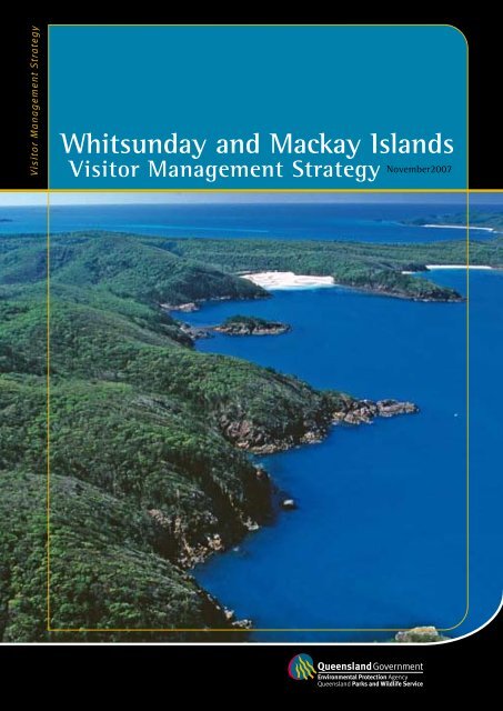
Front cover photograph: <strong>Whitsunday</strong> Isl<strong>and</strong> (Adam Creed, EPA)
Table of contents<br />
1 Executive summary............................................................................................................................... 2<br />
2 Introduction............................................................................................................................................ 4<br />
2.1 Background <strong>and</strong> context....................................................................................................................................................4<br />
2.2 Purpose ................................................................................................................................................................................4<br />
2.3 Planning area.......................................................................................................................................................................4<br />
3 <strong>Strategy</strong> overview.................................................................................................................................. 6<br />
3.1 Conservation values............................................................................................................................................................6<br />
3.2 <strong>Management</strong> environment.................................................................................................................................................6<br />
3.3 <strong>Visitor</strong> environment.............................................................................................................................................................6<br />
4 Planning approach................................................................................................................................. 8<br />
5 <strong>Visitor</strong> management settings.............................................................................................................10<br />
(includes maps 2,3,4 showing settings applied to the planning area)<br />
Table of contents<br />
<br />
6 Strategic directions..............................................................................................................................14<br />
6.1 Conserving natural values ............................................................................................................................................... 14<br />
6.2 Conserving cultural values............................................................................................................................................... 15<br />
6.3 <strong>Visitor</strong> use <strong>and</strong> facilities................................................................................................................................................... 16<br />
6.4 <strong>Management</strong> of high use visitor sites ............................................................................................................................ 17<br />
6.4.1 South Whitehaven Beach, <strong>Whitsunday</strong> Isl<strong>and</strong>.................................................................................................. 17<br />
6.4.2 Chance Bay, <strong>Whitsunday</strong> Isl<strong>and</strong>......................................................................................................................... 18<br />
6.4.3 Tongue Point, <strong>Whitsunday</strong> Isl<strong>and</strong>..................................................................................................................... 18<br />
6.4.4 Beaches at Blue Pearl Bay, Black Isl<strong>and</strong> <strong>and</strong> Langford Spit............................................................................ 19<br />
6.4.5 Brampton Isl<strong>and</strong> ................................................................................................................................................. 19<br />
6.4.6 Refuge Bay, Scawfell Isl<strong>and</strong>............................................................................................................................... 19<br />
6.5 Camping............................................................................................................................................................................ 20<br />
6.6 Resorts <strong>and</strong> developments............................................................................................................................................... 24<br />
6.7 Aircraft .............................................................................................................................................................................. 25<br />
6.8 Education <strong>and</strong> information............................................................................................................................................. 26<br />
6.9 Working with the tourism industry................................................................................................................................. 26<br />
7 <strong>Strategy</strong> review <strong>and</strong> evaluation.........................................................................................................28<br />
8 References.............................................................................................................................................30<br />
9 Acknowledgements..............................................................................................................................31
Executive summary<br />
<br />
<strong>Whitsunday</strong> <strong>and</strong> <strong>Mackay</strong> Isl<strong>and</strong>s <strong>Visitor</strong> <strong>Management</strong> <strong>Strategy</strong><br />
The Queensl<strong>and</strong> Parks <strong>and</strong> Wildlife Service (QPWS) manages<br />
an extensive suite of isl<strong>and</strong> national parks in the<br />
<strong>Whitsunday</strong> <strong>and</strong> <strong>Mackay</strong> regions, part of the Great Barrier<br />
Reef World Heritage Area. The regions are a mecca for<br />
boating, yachting, diving, snorkelling <strong>and</strong> nature-based<br />
activity. More than 1,400,000 people visit the regions each<br />
year <strong>and</strong> this is growing. At some isl<strong>and</strong>s, visitor use is<br />
having an impact on the environment <strong>and</strong> affecting the<br />
quality of visitor experiences.<br />
The <strong>Whitsunday</strong> <strong>and</strong> <strong>Mackay</strong> Isl<strong>and</strong>s <strong>Visitor</strong> <strong>Management</strong><br />
<strong>Strategy</strong> has been developed to ensure that:<br />
»<br />
»<br />
»<br />
»<br />
tourism is environmentally sustainable<br />
the regions outst<strong>and</strong>ing values are professionally<br />
presented<br />
visitors have a rewarding experience<br />
the QPWS, partner organisations <strong>and</strong> tourism industry<br />
work together effectively.<br />
Particular emphasis is placed upon integrated planning <strong>and</strong><br />
policies across isl<strong>and</strong>s, beaches <strong>and</strong> the surrounding Great<br />
Barrier Reef Marine Park.<br />
The <strong>Strategy</strong> provides a policy framework for sustainable<br />
tourism <strong>and</strong> visitor use. Key initiatives include:<br />
»<br />
»<br />
»<br />
»<br />
Apply a system of visitor management settings to<br />
isl<strong>and</strong>s <strong>and</strong> sites to help guide management decision<br />
making, including permit assessment, site planning,<br />
facility development <strong>and</strong> presentation.<br />
Identify high use sites that will be managed in<br />
partnership with tour operators to ensure a very high<br />
st<strong>and</strong>ard of visitor facilities <strong>and</strong> services are provided.<br />
Identify key visitor destinations requiring new or<br />
upgraded facilities <strong>and</strong> information signage.<br />
Develop an investment plan that provides a strategic<br />
basis for seeking funding for facilities improvements<br />
from a range of public <strong>and</strong> private sector sources.<br />
»<br />
»<br />
»<br />
»<br />
»<br />
»<br />
»<br />
Manage visitor use to sensitive sites through seasonal<br />
or permanent access closures.<br />
Establish mechanisms to protect cultural heritage sites<br />
<strong>and</strong> advance the interests of Traditional Owners.<br />
Establish a diverse range of camping opportunities for<br />
commercial operators <strong>and</strong> independent visitors.<br />
Ensure effective communication <strong>and</strong> engagement<br />
forums are in place between QPWS, the Great Barrier<br />
Reef Marine Park Authority (GBRMPA) <strong>and</strong> the<br />
tourism industry.<br />
Negotiate agreements with resorts adjoining national<br />
parks to ensure co-operative management, public access<br />
<strong>and</strong> contributions towards park management.<br />
Form a joint QPWS-GBRMPA-industry forum to<br />
investigate enhanced management of aircraft<br />
throughout the area.<br />
Set the scene for the potential introduction of the<br />
Tourism in Protected Areas (TIPA) initiative into the<br />
<strong>Whitsunday</strong> area.
Recreational boating at Hook Isl<strong>and</strong><br />
Executive summary<br />
<br />
“The region is a mecca for boating, yachting,<br />
diving, snorkelling <strong>and</strong> nature-based activity.”<br />
Sunbakers at Whitehaven Beach Snorkelling - a popular visitor activity Hill Inlet Lookout
Introduction<br />
<br />
<strong>Whitsunday</strong> <strong>and</strong> <strong>Mackay</strong> Isl<strong>and</strong>s <strong>Visitor</strong> <strong>Management</strong> <strong>Strategy</strong><br />
2.1 Background <strong>and</strong> context<br />
The <strong>Whitsunday</strong> <strong>and</strong> <strong>Mackay</strong> area is experiencing<br />
substantial growth. More than 1,400,000 people visit each<br />
year making it one of the most popular tourist destinations<br />
within the Great Barrier Reef World Heritage Area. There is<br />
also significant residential growth in <strong>Mackay</strong> City,<br />
<strong>Whitsunday</strong> <strong>and</strong> Sarina shires. With new residential <strong>and</strong><br />
tourist developments, it is expected that visitor use of<br />
national parks <strong>and</strong> isl<strong>and</strong>s will continue to grow. At some<br />
national park isl<strong>and</strong>s, high visitor use is having a significant<br />
impact on the environment, as well as affecting the quality<br />
of their experience. This <strong>Visitor</strong> <strong>Management</strong> <strong>Strategy</strong> aims<br />
to address these issues.<br />
Isl<strong>and</strong> national parks are key parts of an integrated strategy<br />
to conserve natural <strong>and</strong> cultural heritage in Queensl<strong>and</strong>.<br />
Isl<strong>and</strong>s also offer unique opportunities for eco-tourism <strong>and</strong><br />
recreation, providing significant commercial opportunities<br />
<strong>and</strong> contributing to regional <strong>and</strong> State economies. Despite<br />
this environmental, social <strong>and</strong> economic importance, many<br />
<strong>Whitsunday</strong> <strong>and</strong> <strong>Mackay</strong> isl<strong>and</strong>s have inadequate facilities.<br />
Previous planning efforts have sought to address visitor<br />
management issues in the <strong>Whitsunday</strong> <strong>and</strong> <strong>Mackay</strong> area.<br />
Much of this effort focused on managing the marine<br />
component of visitor use, culminating in the rezoning of<br />
the Great Barrier Reef Marine Park <strong>and</strong> release of the<br />
<strong>Whitsunday</strong> Plan of <strong>Management</strong>, both developed by the<br />
Great Barrier Reef Marine Park Authority (GBRMPA). The<br />
Great Barrier Reef Marine Park Zoning Plan 2003 defines<br />
activities that can occur within the Great Barrier Reef<br />
Marine Park <strong>and</strong> the locations in which they can occur.<br />
Zoning plans try to balance human use with conservation.<br />
The <strong>Whitsunday</strong> Plan of <strong>Management</strong> applies settings that<br />
place limits on vessel size, passenger load, type of craft,<br />
facilities <strong>and</strong> certain activities in the marine park.<br />
The <strong>Whitsunday</strong> <strong>and</strong> <strong>Mackay</strong> Isl<strong>and</strong>s <strong>Visitor</strong> <strong>Management</strong><br />
<strong>Strategy</strong> will build on, but not duplicate, previous planning<br />
efforts. The <strong>Strategy</strong> focuses on national park isl<strong>and</strong>s <strong>and</strong><br />
adjoining beaches rather than the Great Barrier Reef<br />
Marine Park.<br />
2.2 Purpose<br />
The <strong>Whitsunday</strong> <strong>and</strong> <strong>Mackay</strong> Isl<strong>and</strong>s <strong>Visitor</strong> <strong>Management</strong><br />
<strong>Strategy</strong> will provide a framework for future management of<br />
visitors to national parks <strong>and</strong> adjacent beaches.<br />
The <strong>Strategy</strong> will:<br />
1. identify visitor sites <strong>and</strong> patterns of use<br />
2. develop a system of management settings for isl<strong>and</strong>s<br />
<strong>and</strong> individual sites<br />
3. identify sites that require immediate site planning <strong>and</strong><br />
remedial works<br />
4. provide a policy framework for sustainable tourism <strong>and</strong><br />
visitor use.<br />
2.3 Planning area<br />
This <strong>Strategy</strong> applies to offshore national park isl<strong>and</strong>s <strong>and</strong><br />
adjoining beaches between Bowen <strong>and</strong> Sarina in Central<br />
Queensl<strong>and</strong>. The planning area falls wholly or partly within<br />
the Bowen, <strong>Whitsunday</strong>, Sarina <strong>and</strong> Broadsound Shire<br />
Councils, <strong>and</strong> <strong>Mackay</strong> City Council. The following are not<br />
included in the planning area:<br />
» freehold or leasehold l<strong>and</strong> on isl<strong>and</strong>s<br />
» national parks or beaches on the mainl<strong>and</strong><br />
» marine areas below low tide within the Commonwealth<br />
Great Barrier Reef Marine Park or Queensl<strong>and</strong> Great<br />
Barrier Reef Coast Marine Park.
MAP 1 Planning area locality<br />
Introduction
<strong>Strategy</strong> overview<br />
3.1 Conservation values<br />
3.2 <strong>Management</strong> environment<br />
<br />
<strong>Whitsunday</strong> <strong>and</strong> <strong>Mackay</strong> Isl<strong>and</strong>s <strong>Visitor</strong> <strong>Management</strong> <strong>Strategy</strong><br />
The Great Barrier Reef was declared a World Heritage Area<br />
in 1981. It is internationally recognised for its outst<strong>and</strong>ing<br />
natural values, <strong>and</strong> one of only a few sites nominated for all<br />
four natural criteria (refer to www.environment.gov.au/<br />
heritage/worldheritage/sites/gbr/values.html). Although coral<br />
reefs initially made the area famous, it comprises an<br />
extraordinary variety of other plant <strong>and</strong> animal communities,<br />
including fringing coastal reefs, mangroves, seagrass beds,<br />
s<strong>and</strong>y <strong>and</strong> coral cays, s<strong>and</strong>y or muddy bottom communities,<br />
continental isl<strong>and</strong>s <strong>and</strong> deep open ocean areas.<br />
The <strong>Whitsunday</strong> <strong>and</strong> <strong>Mackay</strong> isl<strong>and</strong>s are visually attractive<br />
with rugged l<strong>and</strong>forms, varied geology, s<strong>and</strong>y beaches <strong>and</strong><br />
fringing reefs. Significant natural values are represented,<br />
including the highest vegetation diversity recorded for any<br />
of the Great Barrier Reef continental isl<strong>and</strong>s, with nearly<br />
1000 native plant species (including 20 that are rare <strong>and</strong><br />
threatened). Diverse plant communities such as lowl<strong>and</strong> vine<br />
forest, eucalypt woodl<strong>and</strong>, Pisonia forest <strong>and</strong> grassl<strong>and</strong> are<br />
present. Wildlife is rich <strong>and</strong> varied <strong>and</strong> includes 31 mammal,<br />
more than 200 bird <strong>and</strong> over 50 reptile species. Several<br />
beaches are important nesting sites for green <strong>and</strong><br />
loggerhead turtles.<br />
The planning area is also culturally significant. Aboriginal<br />
people inhabited <strong>Whitsunday</strong> <strong>and</strong> <strong>Mackay</strong> isl<strong>and</strong>s for more<br />
than 6000 years. Today, evidence of this early occupation<br />
includes shell middens, fish traps, stone quarries <strong>and</strong> rock<br />
art. Much of the coast <strong>and</strong> near-shore isl<strong>and</strong>s, cays <strong>and</strong><br />
reefs have special cultural meaning for Traditional Owners,<br />
fulfilling a significant role in their traditional <strong>and</strong><br />
contemporary lifestyles. Hill Inlet, for example is of<br />
particular spiritual importance. The isl<strong>and</strong>s also contain<br />
cultural heritage resources that are evidence of more recent<br />
isl<strong>and</strong> occupation <strong>and</strong> use, including shipwrecks, tramways,<br />
fencelines <strong>and</strong> buildings.<br />
<strong>Visitor</strong> use of national parks <strong>and</strong> beaches is regulated <strong>and</strong><br />
managed by the Queensl<strong>and</strong> Parks <strong>and</strong> Wildlife Service<br />
(QPWS), an entity of the Environmental Protection Agency<br />
(EPA), through the Nature Conservation Act 1992 <strong>and</strong><br />
Marine Parks Act 2004. The EPA has developed the <strong>Mackay</strong>-<br />
<strong>Whitsunday</strong> Regional Coastal <strong>Management</strong> Plan, which<br />
covers the coastal zone <strong>and</strong> provides direction on how<br />
coastal resources in the region will be protected <strong>and</strong><br />
managed in the future.<br />
GBRMPA manages the establishment, control, care <strong>and</strong><br />
development of the Great Barrier Reef Marine Park <strong>and</strong><br />
World Heritage Area through the Great Barrier Reef Marine<br />
Park Act 1975. The Great Barrier Reef Marine Park includes<br />
all waters to the low tide mark. <strong>Visitor</strong> use of state waters<br />
<strong>and</strong> the intertidal zone is managed by the Queensl<strong>and</strong><br />
Government in a complementary manner under the Marine<br />
Parks Act 2004 <strong>and</strong> the Marine Parks (Great Barrier Reef<br />
Coast) Zoning Plan 2004.<br />
Local government has important responsibilities in how the<br />
planning area is developed <strong>and</strong> used. Tourism Queensl<strong>and</strong><br />
<strong>and</strong> regional tourism organisations market the area as a<br />
tourist destination on behalf of local <strong>and</strong> regional tourism<br />
businesses. Commercial operators, resorts <strong>and</strong> other park<br />
neighbours play a critical role in presenting the parks <strong>and</strong><br />
providing infrastructure <strong>and</strong> services.<br />
3.3 <strong>Visitor</strong> environment<br />
The isl<strong>and</strong>s form a significant part of the <strong>Mackay</strong> <strong>and</strong><br />
<strong>Whitsunday</strong> regions, two of Australia’s most attractive<br />
holiday destinations. The regions are popular with domestic<br />
<strong>and</strong> international visitors who come to visit iconic locations<br />
such as Whitehaven Beach. The regions are also an<br />
important component of the Brisbane–Cairns touring route<br />
for travellers exploring the Queensl<strong>and</strong> coast.
Tourism trends<br />
The <strong>Mackay</strong> region (between Laguna Quays <strong>and</strong> Sarina)<br />
recorded 684,000 visitors in the 2005–2006 financial year:<br />
42,000 international <strong>and</strong> 642,000 domestic visitors.<br />
By 2016, Tourism Queensl<strong>and</strong> predicts that the <strong>Mackay</strong><br />
region will host 853,000 visitors.<br />
The <strong>Whitsunday</strong> region (between Bowen <strong>and</strong> Laguna Quays)<br />
recorded 788,000 visitors in the 2005-2006 financial year:<br />
208,000 international <strong>and</strong> 580,000 domestic visitors.<br />
By 2016 it is predicted that the <strong>Whitsunday</strong> region will<br />
host 1,050,000 visitors.<br />
Tourism contributed an estimated $314 million to gross<br />
national product <strong>and</strong> accounted for 12 percent of all<br />
employment in the <strong>Mackay</strong> <strong>and</strong> <strong>Whitsunday</strong> regions<br />
(Tourism Queensl<strong>and</strong>, 1998/99 data). In the <strong>Whitsunday</strong><br />
region, 34.4 percent of the shire’s workers are employed in<br />
tourism enterprises.<br />
The area contains Australia’s largest group of charter boat<br />
operators, with an annual turnover in excess of $100 million,<br />
along with more than 760 commercially registered boats.<br />
Recreation trends<br />
National park isl<strong>and</strong>s <strong>and</strong> beaches are used by residents for<br />
nature-based activities such as camping, bush walking,<br />
scenic viewing, swimming, snorkelling, birdwatching <strong>and</strong><br />
beach activities.<br />
The <strong>Mackay</strong> <strong>and</strong> <strong>Whitsunday</strong> regions have current<br />
populations of 114,000 <strong>and</strong> 29,000 respectively, with<br />
significant residential growth occurring in both places.<br />
By 2016, these regions are predicted to have an additional<br />
20,000 <strong>and</strong> 7000 residents respectively.<br />
The <strong>Whitsunday</strong> region offers some of the world’s best boat<br />
cruising opportunities, with sheltered waters <strong>and</strong> many<br />
safe anchorages. In the <strong>Mackay</strong> <strong>and</strong> <strong>Whitsunday</strong> area,<br />
recreational boat registrations (an indicator of how many<br />
residents access offshore isl<strong>and</strong>s) numbered 14,077 in 2004,<br />
growing annually by between 10 <strong>and</strong> 20 percent. The area<br />
currently has about 850 marina berths, a figure estimated<br />
to double in the next few years.<br />
<strong>Visitor</strong> use of marine parks <strong>and</strong> national<br />
park isl<strong>and</strong>s<br />
No comprehensive figures exist for visitor use of the<br />
planning area. <strong>Visitor</strong> use estimates can be derived from the<br />
GBRMPA Environmental <strong>Management</strong> Charge (EMC) data,<br />
QPWS Commercial Activity Permit returns <strong>and</strong> QPWS<br />
camping data. General figures are provided in Table 3.3.1.<br />
Future visitor levels to isl<strong>and</strong>s in the planning area will be<br />
influenced by both domestic <strong>and</strong> international tourism<br />
patterns <strong>and</strong> residential growth.<br />
<strong>Strategy</strong> overview<br />
<br />
Table 3.3.1<br />
<strong>Visitor</strong> use of <strong>Whitsunday</strong> <strong>and</strong> <strong>Mackay</strong> marine parks <strong>and</strong> isl<strong>and</strong>s<br />
Estimate type 2000 2001 2002 2003 2004 2005<br />
<strong>Visitor</strong> days to marine park 1 533,930 661,853 998,087 890,529 796,291 776,885<br />
Change (%) from previous year 24 51 -11 -11 -2<br />
<strong>Visitor</strong>s to national park isl<strong>and</strong>s 2 72,000 3 84,000 4 94,000 5<br />
not available not available not available<br />
Change (%) from previous year -- 14 11<br />
Camping on national park isl<strong>and</strong>s<br />
(Camper nights) not available not available not available<br />
10,551 12,446 12,885<br />
Change (%) from previous year -- 15 3<br />
Notes: 1. <strong>Visitor</strong> days to marine park in the <strong>Whitsunday</strong> area via commercial tour operators (EMC data, GBRMPA)<br />
2. Number of visitors using commercial tour operators to access national park isl<strong>and</strong>s, not beaches (data from QPWS Commercial Activity Permit returns)<br />
3. Data is for 2002/03<br />
4. Data is for 2003/04<br />
5. Data is for 2004/05<br />
Camping at Crayfish Beach, Hook Isl<strong>and</strong> Lookout from South Molle Isl<strong>and</strong> Bushwalking at Tongue Point
Planning approach<br />
<br />
<strong>Whitsunday</strong> <strong>and</strong> <strong>Mackay</strong> Isl<strong>and</strong>s <strong>Visitor</strong> <strong>Management</strong> <strong>Strategy</strong><br />
A QPWS project team developed this <strong>Strategy</strong>. A multiagency<br />
steering committee comprising representatives from<br />
QPWS, EPA, GBRMPA, Tourism <strong>Whitsunday</strong>, Association of<br />
Marine Park Tourism Operators <strong>and</strong> Tourism Queensl<strong>and</strong><br />
guided the project team.<br />
The planning process involved research into the natural,<br />
social <strong>and</strong> cultural values, <strong>and</strong> tourism <strong>and</strong> recreational use<br />
trends of isl<strong>and</strong>s. <strong>Visitor</strong> sites <strong>and</strong> management issues were<br />
identified, <strong>and</strong> visitor attitudes at key sites surveyed.<br />
The project team visited more than 100 visitor sites between<br />
April <strong>and</strong> December 2005. Community representatives <strong>and</strong><br />
tour operators accompanied QPWS staff on a number of<br />
trips. As part of the assessment process, teams described the<br />
visitor site <strong>and</strong> recorded site parameters <strong>and</strong> levels of visitor<br />
use. For each site, the level of natural <strong>and</strong> human-modified<br />
elements in the l<strong>and</strong>scape was recorded using the QPWS<br />
L<strong>and</strong>scape Classification System. <strong>Visitor</strong> impacts, risks <strong>and</strong><br />
management issues were assessed <strong>and</strong> recorded. This<br />
information was used to classify sites into visitor<br />
management settings.<br />
Hill Inlet<br />
In developing the <strong>Strategy</strong>, community <strong>and</strong> industry<br />
stakeholders were consulted through the establishment of<br />
an Airlie Beach <strong>Management</strong> Advisory Group. This group is<br />
made up of representatives from local government,<br />
community organisations <strong>and</strong> the tourism industry.<br />
Consultation occurred with GBRMPA Tourism <strong>and</strong><br />
Recreation Reef Advisory Committee, <strong>Mackay</strong> <strong>and</strong> Airlie<br />
Beach Local Marine Advisory Committees, Traditional Owner<br />
representatives <strong>and</strong> tourism operators.<br />
A public submission process was conducted in late 2005<br />
involving a “call for comment”. Submissions informed the<br />
early stages of strategy development. A draft <strong>Strategy</strong> was<br />
released for public comment in December 2006.<br />
The <strong>Whitsunday</strong> <strong>and</strong> <strong>Mackay</strong> Isl<strong>and</strong>s <strong>Visitor</strong> <strong>Management</strong><br />
<strong>Strategy</strong> has been formally adopted as EPA policy <strong>and</strong> will<br />
provide a framework for future visitor management.
Hill Inlet<br />
Planning approach<br />
<br />
“ The planning process involved research into<br />
the natural, social <strong>and</strong> cultural values,<br />
<strong>and</strong> tourism <strong>and</strong> recreational use...”<br />
Facilities at Whitehaven Beach Banyan Trees on Long Isl<strong>and</strong> <strong>Mackay</strong> Marina
<strong>Visitor</strong> management settings<br />
The following section describes a broad framework for<br />
managing visitor use of isl<strong>and</strong>s centred on a system of<br />
visitor management settings applied to isl<strong>and</strong>s <strong>and</strong><br />
individual sites. Settings will guide decision making,<br />
including permit assessment, site planning, facility<br />
development <strong>and</strong> presentation.<br />
Approach<br />
Isl<strong>and</strong>s <strong>and</strong> beaches will be managed according to the<br />
following settings:<br />
1. Developed 2. High use 3. Moderate use<br />
4. Natural 5. Protected<br />
10<br />
<strong>Whitsunday</strong> <strong>and</strong> <strong>Mackay</strong> Isl<strong>and</strong>s <strong>Visitor</strong> <strong>Management</strong> <strong>Strategy</strong><br />
Classifying visitor sites in natural areas is an important<br />
The names <strong>and</strong> broad intent of settings complement those<br />
management process. The classification system places a adopted for the marine environment in the <strong>Whitsunday</strong> Plan<br />
visitor site at a specified level of “naturalness”, ensuring a of <strong>Management</strong> (GBRMPA 1998).<br />
mix of visitor sites remains available to meet park users’<br />
Maps 2, 3 <strong>and</strong> 4 show settings applied to isl<strong>and</strong>s <strong>and</strong> visitor<br />
needs. It also enables managers to decide on the amount,<br />
sites. Table 5.1 confirms which visitor sites fall within each<br />
type <strong>and</strong> capacity of facilities developed at visitor sites.<br />
setting. Tables 5.2 <strong>and</strong> 5.3 describe management intent <strong>and</strong><br />
Desired outcomes<br />
»<br />
»<br />
»<br />
A consistent <strong>and</strong> justifiable framework is in place for<br />
managers to make decisions regarding commercial <strong>and</strong><br />
independent visitor use.<br />
Integrated <strong>and</strong> simplified visitor management operates<br />
across isl<strong>and</strong>s <strong>and</strong> the adjoining marine park.<br />
Certainty exists for the tourism industry regarding<br />
QPWS policy.<br />
visitor use guidelines for each setting.<br />
Policies, guidelines <strong>and</strong> actions<br />
Manage isl<strong>and</strong>s <strong>and</strong> beaches according to visitor<br />
management settings assigned in maps 2, 3 <strong>and</strong> 4, table<br />
5.1 <strong>and</strong> guidelines in tables 5.2 <strong>and</strong> 5.3.<br />
Assess <strong>and</strong> administer new commercial activity permits<br />
consistent with settings <strong>and</strong> policies in this <strong>Strategy</strong>.<br />
Manage camping areas according to visitor management<br />
settings <strong>and</strong> policies in section 6.5.<br />
Table 5.1 <strong>Visitor</strong> sites within each visitor management setting<br />
Setting<br />
<strong>Visitor</strong> site<br />
Developed Beaches adjacent to:<br />
Camp Isl<strong>and</strong> — Camp Isl<strong>and</strong> Tourist Resort<br />
South Molle Isl<strong>and</strong> — South Molle Isl<strong>and</strong> Resort<br />
Long Isl<strong>and</strong> — Club Croc Resort, Peppers Palm Bay Resort <strong>and</strong> South Long Isl<strong>and</strong> Nature Lodge<br />
Hook Isl<strong>and</strong> — Hook Isl<strong>and</strong> Wilderness Resort<br />
Lindeman Isl<strong>and</strong> — Club Med Resort<br />
Brampton Isl<strong>and</strong> — Brampton Isl<strong>and</strong> Resort<br />
Keswick Isl<strong>and</strong> — Keswick Isl<strong>and</strong> Development<br />
Table continued next page<br />
»<br />
»<br />
»
Table 5.1<br />
Setting<br />
High use<br />
Moderate use<br />
Natural<br />
<strong>Visitor</strong> sites within each visitor management setting [CONTINUED]<br />
<strong>Visitor</strong> site<br />
Hayman Isl<strong>and</strong> — Blue Pearl Bay Beach<br />
Langford Isl<strong>and</strong> — Langford Spit<br />
Black Isl<strong>and</strong> — Black Isl<strong>and</strong> Beach<br />
<strong>Whitsunday</strong> Isl<strong>and</strong> — Tongue Point, Lookout Beach, Betty’s Beach, South Whitehaven Beach, Chance Bay<br />
Brampton Isl<strong>and</strong> — Jetty site, Western Bay, Hillsborough Lookout, Carlisle Lookout, Brampton Walking<br />
Track Circuit<br />
Scawfell Isl<strong>and</strong> — Refuge Bay<br />
Gloucester Isl<strong>and</strong> — Bona Bay<br />
North Molle Isl<strong>and</strong> — Cockatoo Beach<br />
South Molle Isl<strong>and</strong> — S<strong>and</strong>y Bay, Spion Kop, Cultural Quarry, walking tracks, Paddle Bay<br />
Long Isl<strong>and</strong> — P<strong>and</strong>anus Bay, Fish Bay, S<strong>and</strong>y Bay, walking tracks north of S<strong>and</strong>y Bay<br />
Hook Isl<strong>and</strong> — Nara Art Site, Maureen’s Cove, Crayfish Beach, Bloodhorn Beach<br />
Border Isl<strong>and</strong> — Cateran Bay<br />
<strong>Whitsunday</strong> Isl<strong>and</strong> — Central Whitehaven Beach, Sawmill Beach, Dugong Beach, Dugong-Sawmill<br />
Walking Track<br />
Haslewood Isl<strong>and</strong> — Stockyard / Chalkies Beach<br />
Henning Isl<strong>and</strong> — Northern Spit<br />
Lindeman Isl<strong>and</strong> — Boat Port, Plantation Beach, Coconut Beach, Gap Beach, Mt Oldfield, walking tracks<br />
Seaforth Isl<strong>and</strong> — Orchid Beach, walking tracks, South Beach<br />
Goldsmith Isl<strong>and</strong> — Roylen Bay<br />
Rabbit Isl<strong>and</strong> — Tug’s Point<br />
Newry Isl<strong>and</strong> — Camping Area, Sunset Beach, walking tracks<br />
Carlisle Isl<strong>and</strong> — Neil’s (S<strong>and</strong>y) Beach<br />
Brampton Isl<strong>and</strong> — Turtle Bay, Dinghy Bay West<br />
St Bees Isl<strong>and</strong> — Turtle Beach, Homestead Bay<br />
Flat Top Isl<strong>and</strong><br />
Camp Isl<strong>and</strong><br />
Gloucester Isl<strong>and</strong> — East Side Bay<br />
Saddleback Isl<strong>and</strong><br />
Armit Isl<strong>and</strong><br />
Denman Isl<strong>and</strong><br />
Tancred Isl<strong>and</strong><br />
Planton Isl<strong>and</strong><br />
Long Isl<strong>and</strong> — South Long Isl<strong>and</strong> Walking Track (proposed)<br />
Cid Isl<strong>and</strong> — Homestead Bay<br />
Hook Isl<strong>and</strong> — Curlew Beach, Steen’s Beach<br />
<strong>Whitsunday</strong> Isl<strong>and</strong> — Joes Beach, Naris Beach, North Whitehaven Beach, Peter Bay, <strong>Whitsunday</strong> Peak<br />
Walking Trail<br />
Henning Isl<strong>and</strong> — Geographers Bay<br />
Maher Isl<strong>and</strong> — Phantoms Cave<br />
Shaw Isl<strong>and</strong> — Neck Bay<br />
Thomas Isl<strong>and</strong> — Naked Lady Beach, Sea Eagle Beach<br />
South Repulse Isl<strong>and</strong> – South Repulse Beach<br />
Goldsmith Isl<strong>and</strong> — Sting Ray Bay, Looking Glass Bay<br />
Linne Isl<strong>and</strong><br />
Outer Newry Isl<strong>and</strong> — Hut <strong>and</strong> walking track<br />
Carlisle Isl<strong>and</strong> — Melaleuca Swamp<br />
Brampton Isl<strong>and</strong> — Dinghy Bay East, Oak Bay<br />
Cockermouth Isl<strong>and</strong><br />
Keswick Isl<strong>and</strong> — Singapore Bay, Victor Bay<br />
St Bees Isl<strong>and</strong> — North <strong>and</strong> South Egremont beaches<br />
Penrith Isl<strong>and</strong><br />
Round Top Isl<strong>and</strong><br />
Prudhoe Isl<strong>and</strong><br />
Digby Isl<strong>and</strong><br />
Curlew Isl<strong>and</strong> — North Beach, South Beach<br />
South Percy Isl<strong>and</strong> — North West Beach<br />
Table continued next page<br />
<strong>Visitor</strong> management settings<br />
11
Table 5.1<br />
Setting<br />
Protected<br />
<strong>Visitor</strong> sites within each visitor management setting [CONTINUED]<br />
<strong>Visitor</strong> site<br />
Holbourne Isl<strong>and</strong><br />
Middle Isl<strong>and</strong><br />
Olden Isl<strong>and</strong><br />
Grassy Isl<strong>and</strong><br />
Double Cone Isl<strong>and</strong><br />
Shute Isl<strong>and</strong><br />
Deloraine Isl<strong>and</strong><br />
<strong>Whitsunday</strong> Isl<strong>and</strong> — Hill Inlet, Far North Whitehaven Beach<br />
Pentecost Isl<strong>and</strong><br />
Shaw Isl<strong>and</strong> — Burning Point beaches<br />
Carlisle Isl<strong>and</strong> — Squeaky Beach<br />
Mausoleum Isl<strong>and</strong><br />
Calder Isl<strong>and</strong><br />
Wigton Isl<strong>and</strong><br />
Bushy Islet<br />
Pine Islet<br />
Note: Maps show settings for more isl<strong>and</strong>s. Isl<strong>and</strong>s listed above are those with identified visitor sites.<br />
12<br />
<strong>Whitsunday</strong> <strong>and</strong> <strong>Mackay</strong> Isl<strong>and</strong>s <strong>Visitor</strong> <strong>Management</strong> <strong>Strategy</strong><br />
Table 5.2<br />
1<br />
2<br />
3<br />
4<br />
5<br />
Description <strong>and</strong> guidelines for management settings<br />
Setting Description <strong>Management</strong> intent <strong>Management</strong> guidelines<br />
Developed<br />
High use<br />
Moderate use<br />
Natural<br />
Protected<br />
Beaches<br />
immediately<br />
adjoining resorts<br />
<strong>and</strong> major<br />
residential areas<br />
Sites providing a<br />
focus for tourism<br />
Sites providing for<br />
significant levels<br />
of tourism <strong>and</strong><br />
local recreation<br />
<strong>Visitor</strong> sites<br />
generally free of<br />
facilities<br />
Natural areas set<br />
aside for<br />
conservation with<br />
minimal visitor use<br />
Manage in close co-operation with<br />
the relevant resort or development.<br />
Provide for sustainable interaction<br />
between the resort or development<br />
<strong>and</strong> the adjacent beach.<br />
Manage for high levels of<br />
visitor use.<br />
Manage for sustainable visitor use.<br />
Manage for conservation<br />
outcomes while allowing for low<br />
levels of self-reliant visitor use.<br />
Manage for conservation<br />
outcomes. Some areas with unique<br />
or outst<strong>and</strong>ing conservation <strong>and</strong>/<br />
or cultural value are seasonally or<br />
permanently closed to visitors.<br />
»<br />
»<br />
»<br />
»<br />
»<br />
»<br />
»<br />
»<br />
»<br />
»<br />
»<br />
»<br />
»<br />
»<br />
»<br />
»<br />
Each site will require detailed<br />
assessment of adjacent development<br />
proposals; may also require additional<br />
site planning to determine appropriate<br />
visitor management arrangements.<br />
Sites will have appropriate facilities<br />
to minimise visitor impacts <strong>and</strong> help<br />
improve the visitor experience.<br />
Each site will have specific strategies<br />
to guide site development <strong>and</strong><br />
management as per section 6.4.<br />
Sites will be managed for large groups<br />
of people.<br />
Sites will have appropriate facilities to<br />
minimise visitor impacts <strong>and</strong> enhance<br />
the visitor experience.<br />
<strong>Visitor</strong> sites generally free of facilities<br />
unless they are essential to minimise<br />
visitor impacts e.g. toilets.<br />
Commercial activity permits may be issued.<br />
Group activity permits <strong>and</strong> special<br />
activity permits will not be issued.<br />
Some sites may be set aside for noncommercial<br />
use only.<br />
No generators or compressors permitted.<br />
No facilities provided.<br />
Group activities <strong>and</strong> special activity not<br />
permitted.<br />
Filming generally not permitted.<br />
Commercial use generally not permitted<br />
(may be permitted in special<br />
circumstances – see section 6.1).<br />
Free <strong>and</strong> independent traveller use<br />
permitted, except for locations with<br />
seasonal or permanent closures.<br />
No generators or compressors permitted.
Table 5.3<br />
<strong>Visitor</strong> use permitted within each setting.<br />
<strong>Visitor</strong> use<br />
Setting<br />
Developed High use Moderate use Natural Protected<br />
Commercial use Yes 1 Yes Yes Optional 2 Optional 3<br />
Access for free <strong>and</strong> independent travellers Yes Yes Yes Yes Yes, except for<br />
closed areas<br />
Permanent facilities (includes walking tracks) Yes Yes Yes Optional No 4<br />
Special activities 5 Optional Optional Optional No No<br />
Group activities 6 Yes Yes Yes No No<br />
Filming for advertising <strong>and</strong> feature films Yes Yes Yes Yes No 7<br />
Use of compressors <strong>and</strong> generators Yes Optional Optional No No<br />
Commercial tented accommodation Yes Optional No No No<br />
Commercial reef walking tours No 7 No 8 No No No<br />
Motorised water sports 9 Yes No No No No<br />
Motor vehicle use on beaches 10 Yes No No No No<br />
Goods <strong>and</strong> services vending <strong>and</strong> hire Yes No No No No<br />
Notes:<br />
1 Yes = allowed, but if permit or agreement required, subject to<br />
assessment <strong>and</strong> conditions<br />
2 Optional = at discretion of QPWS. Individual applications will be<br />
assessed by QPWS with consideration to site characteristics,<br />
potential environmental impacts, potential effect on other park<br />
users, availability of a suitable alternative location <strong>and</strong> other site<br />
factors that might exist<br />
3 QPWS may permit access under special conditions for ecocertified<br />
commercial tour operators (see section 6.1)<br />
4 No = not permitted<br />
5 Special activity as defined in section 104 of the Queensl<strong>and</strong><br />
Marine Parks Regulations 2006<br />
<strong>Whitsunday</strong> Isl<strong>and</strong><br />
6 Group activity = organised use of a protected area in a way that may<br />
interfere with general public use of the area<br />
7 QPWS may allow exceptions under strict conditions after<br />
considering: environmental impacts; effect on other park users;<br />
suitability of alternative locations <strong>and</strong> potential management or<br />
significant public benefit<br />
8 Unless allowed under an existing permission<br />
9 Motorised water sport as defined in the GBRMPA <strong>Whitsunday</strong> Plan of<br />
<strong>Management</strong> 1998<br />
10 Motor vehicle as defined in the Nature Conservation (Protected Areas<br />
<strong>Management</strong>) Regulation 2006<br />
<strong>Visitor</strong> management settings<br />
13
Strategic directions<br />
14<br />
<strong>Whitsunday</strong> <strong>and</strong> <strong>Mackay</strong> Isl<strong>and</strong>s <strong>Visitor</strong> <strong>Management</strong> <strong>Strategy</strong><br />
The following section specifies policies, guidelines <strong>and</strong><br />
actions to help with visitor management of <strong>Whitsunday</strong> <strong>and</strong><br />
<strong>Mackay</strong> national park isl<strong>and</strong>s <strong>and</strong> beaches.<br />
6.1 Conserving natural values<br />
<strong>Visitor</strong>s using isl<strong>and</strong>s may impact on natural values by:<br />
transporting weeds from one visitor site to another<br />
»<br />
»<br />
»<br />
»<br />
»<br />
disturbing dune vegetation which contributes to erosion<br />
disturbing wildlife (such as seabirds <strong>and</strong> turtles) during<br />
important breeding <strong>and</strong> roosting periods<br />
damaging vegetation <strong>and</strong> areas of reef flat when<br />
moving between vessels <strong>and</strong> isl<strong>and</strong>s<br />
leaving rubbish <strong>and</strong> waste at visitor sites.<br />
Many isl<strong>and</strong>s <strong>and</strong> beaches support significant wildlife <strong>and</strong><br />
cultural values that are sensitive to visitor use. Bushy <strong>and</strong><br />
Redbill islets are particularly important. The values of these<br />
places will be managed to minimise visitor use through<br />
seasonal or permanent access closures.<br />
Desired outcomes<br />
»<br />
»<br />
»<br />
<strong>Visitor</strong> use is ecologically sustainable <strong>and</strong> has minimal<br />
impact on natural values.<br />
Isl<strong>and</strong>s <strong>and</strong> sites of natural significance are protected.<br />
<strong>Visitor</strong>s are aware of appropriate behaviour when<br />
visiting natural areas <strong>and</strong> the potential impacts they<br />
may have on park values.<br />
Policies, guidelines <strong>and</strong> actions<br />
»<br />
»<br />
»<br />
»<br />
Minimise disturbance to native plant communities <strong>and</strong><br />
wildlife through site planning <strong>and</strong> infrastructure placement.<br />
Develop <strong>and</strong> distribute information on minimal impact<br />
practices to isl<strong>and</strong> visitors.<br />
Work with the tourism industry to apply minimum<br />
impact practices to tourism operations.<br />
Maintain the policy of no fires or domestic animals on<br />
national park isl<strong>and</strong>s <strong>and</strong> adjacent beaches.<br />
»<br />
»<br />
»<br />
»<br />
»<br />
»<br />
»<br />
»<br />
Apply seasonal access restrictions (1 October–31 March<br />
inclusive) to protect natural values on Armit, Double<br />
Cone, East Repulse, Grassy, Holbourne <strong>and</strong> South<br />
Repulse isl<strong>and</strong>s, Steen’s Beach (Hook Isl<strong>and</strong>) <strong>and</strong><br />
Burning Point Beach (Shaw Isl<strong>and</strong>).<br />
Limit access to Bushy <strong>and</strong> Redbill islets for research <strong>and</strong><br />
monitoring purposes only, through declaration as<br />
national park (scientific).<br />
Apply a permanent access restriction to Bird Isl<strong>and</strong>.<br />
Keep visitor access to Hill Inlet <strong>and</strong> wetl<strong>and</strong> areas inl<strong>and</strong><br />
from Whitehaven Beach to an absolute minimum.<br />
Encourage tour operators to obtain eco-certification<br />
through provision of tangible incentives, including<br />
extended permit terms <strong>and</strong> inclusion in EPA / QPWS<br />
marketing <strong>and</strong> promotion.<br />
Consider tour operator access to protected settings<br />
(setting 5) where the operator:<br />
›<br />
›<br />
›<br />
›<br />
›<br />
has advanced eco-certification<br />
has demonstrated experience <strong>and</strong> capabilities to<br />
operate with minimal impact in sensitive areas<br />
is prepared to contribute to park management at the<br />
site (e.g. weed control, litter collection, wildlife<br />
monitoring etc.)<br />
can demonstrate that the site provides a significant<br />
environmental or cultural education experience or<br />
management benefit<br />
can demonstrate that the activity cannot reasonably<br />
occur in another less sensitive locality.<br />
The <strong>Whitsunday</strong> Plan of <strong>Management</strong> provides for<br />
commercial reefwalking at Black Isl<strong>and</strong> (identified as a high<br />
use setting). This provision will continue as an exception to<br />
this strategy for tour operators with existing permission.<br />
Encourage commercial tour operators to provide their<br />
own waste management facilities when accessing<br />
isl<strong>and</strong>s without established toilet facilities. Phase out<br />
permitted access for operators without such facilities.<br />
Operators who are directly affected by this policy will be<br />
identified <strong>and</strong> contacted to allow adequate time to<br />
adjust their operations.
Cid Harbour<br />
Views of Shaw Isl<strong>and</strong> from Lindeman Isl<strong>and</strong><br />
Whitehaven Beach<br />
Opportunity<br />
6.2 Conserving cultural values<br />
A significant Indigenous cultural relationship with the Great<br />
Barrier Reef <strong>and</strong> isl<strong>and</strong>s predates non-Indigenous<br />
involvement in the area. Contemporary Indigenous peoples<br />
are attempting to retain their cultural association with their<br />
values <strong>and</strong> use of the area, in the face of increasing pressure<br />
from coastal development, commercial fishing <strong>and</strong><br />
recreational <strong>and</strong> tourism use. Native title claim applications,<br />
lodged by the Juru (Cape Upstart area), Gia (Proserpine<br />
area), Yuibera (<strong>Mackay</strong> area), Darumbal (Percy Isles area)<br />
<strong>and</strong> Barada, Barna, Kabalbara <strong>and</strong> Yetimarla (Cape<br />
Palmerston area) peoples cover various national park isl<strong>and</strong>s.<br />
The Ngaro people are also associated with the <strong>Whitsunday</strong><br />
isl<strong>and</strong>s. Isl<strong>and</strong>s also contain cultural heritage resources that<br />
are remnants of the region’s more recent settlement <strong>and</strong><br />
development.<br />
<strong>Visitor</strong>s are interested to learn about the area’s cultural<br />
significance. However visitors can damage cultural sites<br />
through souveniring cultural artefacts, v<strong>and</strong>alism, graffiti<br />
<strong>and</strong> disturbing fragile sites. Traditional Owners keep the<br />
location of many cultural sites secret to avoid visitor<br />
disturbance.<br />
Desired outcomes<br />
»<br />
»<br />
»<br />
QPWS will consider limited access for eco-certified<br />
tour operators to protected setting sites, where a<br />
significant environmental or cultural education<br />
experience for visitors or a management benefit<br />
is provided <strong>and</strong> the activity cannot occur in<br />
another setting.<br />
Partnerships exist between Indigenous peoples, tour<br />
operators <strong>and</strong> QPWS to ensure cultural values <strong>and</strong> sites<br />
are appropriately protected <strong>and</strong> presented.<br />
<strong>Visitor</strong> use has minimal impact on cultural values.<br />
Indigenous communities’ aspirations to participate in<br />
the tourism industry are explored <strong>and</strong> appropriately<br />
included in tourism planning initiatives.<br />
Policies, guidelines <strong>and</strong> actions<br />
»<br />
»<br />
»<br />
»<br />
»<br />
»<br />
Promote <strong>and</strong> foster active partnerships between QPWS<br />
<strong>and</strong> Traditional Owners to enable the management,<br />
protection <strong>and</strong> presentation of isl<strong>and</strong>s.<br />
Support an active role for Traditional Owners in<br />
providing tourism services to significant cultural sites.<br />
Collaborate with Traditional Owners to manage visitor<br />
use of significant cultural sites at Nara Inlet (Hook<br />
Isl<strong>and</strong>), South Molle Isl<strong>and</strong> <strong>and</strong> Hill Inlet (<strong>Whitsunday</strong><br />
Isl<strong>and</strong>), including preparing site plans, improving<br />
facilities <strong>and</strong> on-site interpretation.<br />
After consulting Traditional Owners <strong>and</strong> other<br />
stakeholders, explore opportunities to give visitor sites<br />
<strong>and</strong> locations suitable Indigenous names.<br />
Undertake cultural heritage impact assessments before<br />
new facilities are developed <strong>and</strong>/or major<br />
redevelopments are undertaken.<br />
Undertake a cultural heritage study in the <strong>Whitsunday</strong><br />
region to identify significant cultural heritage places on<br />
isl<strong>and</strong>s <strong>and</strong> investigate management requirements,<br />
including listing of State significant places on the<br />
Queensl<strong>and</strong> Heritage Register.<br />
Flat Top Isl<strong>and</strong> near <strong>Mackay</strong> is about to be<br />
designated as a national park. Round Top Isl<strong>and</strong><br />
National Park already exists nearby. An opportunity<br />
exists to create a new amalgamated national park<br />
with a suitable Indigenous name.<br />
The Nara Inlet art site, Dugong–Sawmill walking<br />
track, South Molle quarry site <strong>and</strong> Newry Isl<strong>and</strong><br />
camping area could be given Indigenous names.<br />
Opportunity Opportunity<br />
Strategic directions<br />
15
16<br />
<strong>Whitsunday</strong> <strong>and</strong> <strong>Mackay</strong> Isl<strong>and</strong>s <strong>Visitor</strong> <strong>Management</strong> <strong>Strategy</strong><br />
6.3 <strong>Visitor</strong> use AND FACILITIES Policies, guidelines <strong>and</strong> actions<br />
<strong>Visitor</strong>s to the <strong>Whitsunday</strong> <strong>and</strong> <strong>Mackay</strong> isl<strong>and</strong>s participate in<br />
a wide range of activities, including nature appreciation,<br />
snorkelling, diving, picnicking, bushwalking, boating,<br />
motorised <strong>and</strong> non-motorised water sports, beach games<br />
<strong>and</strong> adventure activities. National parks <strong>and</strong> adjacent<br />
beaches are suitable locations for some of these while<br />
others are better suited to locations where nature<br />
conservation is not the primary purpose.<br />
Extensive walking track networks are found on South Molle,<br />
Long, Lindeman <strong>and</strong> Brampton isl<strong>and</strong>s <strong>and</strong> shorter walking<br />
tracks are located on Newry, Seaforth <strong>and</strong> <strong>Whitsunday</strong> isl<strong>and</strong>s<br />
(the last of which includes an informal trail between Cid<br />
Harbour <strong>and</strong> <strong>Whitsunday</strong> Peak). There are also opportunities<br />
for beach walking, particularly on Whitehaven Beach.<br />
QPWS is sometimes requested to allow special events such<br />
as large commercial beach parties <strong>and</strong> fireworks displays on<br />
isl<strong>and</strong>s <strong>and</strong> nearby beaches. Similarly, clubs <strong>and</strong> other<br />
community groups request access to these areas for organised<br />
events. Beach games, music, food, alcohol, marquees <strong>and</strong><br />
other structures associated with some special events may<br />
conflict with nature-based experiences of other visitors.<br />
There can also be litter <strong>and</strong> waste management problems.<br />
In addition to visitor activities during the day, QPWS is<br />
sometimes requested to consider night time activities, such<br />
as formal beach dinners <strong>and</strong> major filming.<br />
Educational groups often use isl<strong>and</strong>s for field trips <strong>and</strong><br />
environmental education. These groups can be quite large<br />
<strong>and</strong> may exceed camping area capacities.<br />
QPWS does not have accurate data on the number of<br />
people visiting sites on national park isl<strong>and</strong>s, either as part<br />
of a commercial tour or independently.<br />
Desired outcomes<br />
»<br />
»<br />
»<br />
»<br />
»<br />
<strong>Visitor</strong>s have minimal impact on the natural values of<br />
isl<strong>and</strong>s.<br />
<strong>Visitor</strong> use is managed at sustainable levels, providing<br />
quality experiences for all visitors.<br />
A range of opportunities exists for visitors, including a<br />
suitable mix of commercial <strong>and</strong> non-commercial use.<br />
<strong>Management</strong> policies <strong>and</strong> systems address the expected<br />
increasing dem<strong>and</strong> for use of isl<strong>and</strong>s.<br />
This <strong>Strategy</strong> guides the development <strong>and</strong> implementation<br />
of a comprehensive capital works program.<br />
»<br />
»<br />
»<br />
»<br />
»<br />
»<br />
»<br />
Manage all walking tracks to a predetermined st<strong>and</strong>ard.<br />
Allow expansion of the current level of permitted special<br />
events on national parks <strong>and</strong> adjacent beaches only<br />
where compelling circumstances exist such as significant<br />
management or public benefit.<br />
Mark <strong>and</strong> manage, with minimal improvements,<br />
the Cid Harbour–<strong>Whitsunday</strong> Peak walking trail.<br />
<strong>Visitor</strong>s will need to be experienced bushwalkers <strong>and</strong><br />
totally self-reliant. Commercial tour operator use of the<br />
trail will be subject to a QPWS safety assessment <strong>and</strong><br />
will be managed through a commercial activity permit<br />
or agreement.<br />
Allow educational groups to occasionally exceed<br />
maximum group sizes set for camping areas where a<br />
sound practical reason exists <strong>and</strong> the group is<br />
adequately supervised to ensure minimal visitor impact.<br />
Develop a Great Walk involving sailing <strong>and</strong> boating<br />
between several <strong>Whitsunday</strong> isl<strong>and</strong>s, with a series of<br />
new or upgraded short walks to viewing spots.<br />
Undertake surveys to measure visitor use at high use<br />
sites <strong>and</strong> more broadly throughout the <strong>Whitsunday</strong>s to<br />
better underst<strong>and</strong> current <strong>and</strong> future use <strong>and</strong> visitor<br />
satisfaction levels.<br />
Co-ordinate available funds <strong>and</strong> resources to implement<br />
the policies <strong>and</strong> programs arising from this <strong>Strategy</strong>.<br />
This document will provide a strategic basis for seeking<br />
additional funding from a range of sources. Table 6.3<br />
identifies significant capital investment requirements<br />
<strong>and</strong> includes a:<br />
›<br />
›<br />
›<br />
Priority rating (high, medium or low)<br />
Target date for completion<br />
Potential funding source.<br />
The Cid Harbour–<strong>Whitsunday</strong> Peak walking trail<br />
will be marked <strong>and</strong> managed with minimal<br />
improvements. <strong>Visitor</strong>s will need to be<br />
experienced bushwalkers <strong>and</strong> totally self-reliant.<br />
Opportunity
Table 6.3 Significant capital investment requirements<br />
Investment Priority Target<br />
date<br />
Potential funding source<br />
Public (State <strong>and</strong> Private<br />
Commonwealth)<br />
Comment<br />
Redevelop lookouts at Tongue Point, <strong>Whitsunday</strong> Isl<strong>and</strong>. High 2007 P<br />
Develop major on-site interpretation at Tongue Point,<br />
<strong>Whitsunday</strong> Isl<strong>and</strong>.<br />
Upgrade facilities <strong>and</strong> walking tracks on Tongue Point,<br />
<strong>Whitsunday</strong> Isl<strong>and</strong>.<br />
High 2008 P<br />
High 2009 P P<br />
Develop all-tide access in Tongue Bay, <strong>Whitsunday</strong> Isl<strong>and</strong>. High 2009 P P<br />
Redevelop day-use <strong>and</strong> camping area at South<br />
Whitehaven Beach, <strong>Whitsunday</strong> Isl<strong>and</strong>.<br />
Replace <strong>and</strong> upgrade toilet facilities at South Whitehaven<br />
Beach, <strong>Whitsunday</strong> Isl<strong>and</strong>.<br />
Develop major on-site interpretation at South<br />
Whitehaven Beach, <strong>Whitsunday</strong> Isl<strong>and</strong>.<br />
Develop walking track from Chance Bay to South<br />
Whitehaven Beach, <strong>Whitsunday</strong> Isl<strong>and</strong>.<br />
Develop lookout at South Whitehaven Beach,<br />
<strong>Whitsunday</strong> Isl<strong>and</strong>.<br />
High 2007 P<br />
High 2007 P<br />
High 2008 P<br />
Subject to<br />
feasibility <strong>and</strong><br />
marine site plan<br />
High 2009 P Part of Great<br />
Walks project.<br />
Medium 2009 P<br />
Develop Great Walk on <strong>Whitsunday</strong> isl<strong>and</strong>s. High 2009 P State-wide<br />
initiative to<br />
develop Great<br />
Walks across<br />
Queensl<strong>and</strong><br />
Redevelop area at Sawmill Beach, <strong>Whitsunday</strong> Isl<strong>and</strong>. High 2010 P<br />
Develop major on-site interpretation in the Dugong–<br />
Sawmill area, <strong>Whitsunday</strong> Isl<strong>and</strong>.<br />
Low 2011 P<br />
Redevelop camping area at Northern Spit, Henning Isl<strong>and</strong>. Medium 2010 P<br />
Redevelop facilities at Nara Rock Art site, Hook Isl<strong>and</strong>. Medium 2007 P<br />
Strategic directions<br />
17<br />
Develop major on-site interpretation at Nara Rock Art site, Medium 2008 P<br />
Hook Isl<strong>and</strong>.<br />
Develop all-tide access at Black Isl<strong>and</strong> Beach. Low 2016 P<br />
Develop major on-site interpretation at South Molle Isl<strong>and</strong>. High 2009 P<br />
Redevelop campground at S<strong>and</strong>y Bay, South Molle Isl<strong>and</strong>. Medium 2009 P<br />
Redevelop campground at Paddle Bay, South Molle Isl<strong>and</strong>. Low 2011 P<br />
Develop walking tracks behind South Long Isl<strong>and</strong> Nature<br />
Lodge, Long Isl<strong>and</strong>.<br />
Low 2016 P<br />
Redevelop campground at Bona Bay, Gloucester Isl<strong>and</strong>. Low 2016 P<br />
Develop campground at Plantation Beach, Lindeman Isl<strong>and</strong>. Low 2011 P<br />
Redevelop day-use area at Western Bay, Brampton Isl<strong>and</strong>. Medium 2010 P<br />
Subject to<br />
feasibility <strong>and</strong><br />
marine site plan<br />
Subject to<br />
feasibility study<br />
Develop facilities adjacent to the Brampton jetty site. Medium 2010 P P<br />
Develop major on-site interpretation at Brampton Isl<strong>and</strong>. Medium 2010 P<br />
Develop major on-site interpretation at Newry Isl<strong>and</strong>. Low 2007 P<br />
Develop campground at Turtle Beach, St Bees Isl<strong>and</strong>. Low 2009 P<br />
Redevelop visitor area at Refuge Bay, Scawfell Isl<strong>and</strong> Medium 2009 P P
Snorkelling<br />
18<br />
<strong>Whitsunday</strong> <strong>and</strong> <strong>Mackay</strong> Isl<strong>and</strong>s <strong>Visitor</strong> <strong>Management</strong> <strong>Strategy</strong><br />
6.4 <strong>Management</strong> of High use visitor sites<br />
Sites within the high use setting are either currently a focus<br />
for tourism <strong>and</strong> have high levels of visitor use, or are sites<br />
that will become a focal point in the future as a planned<br />
outcome of this <strong>Strategy</strong>. High use sites are:<br />
»<br />
»<br />
»<br />
»<br />
»<br />
»<br />
South Whitehaven Beach<br />
Chance Bay<br />
Tongue Point <strong>and</strong> Lookout Beach<br />
Beaches at Blue Pearl Bay, Black Isl<strong>and</strong> <strong>and</strong> Langford<br />
Isl<strong>and</strong> (Spit)<br />
Brampton Isl<strong>and</strong> walking track circuit, Brampton Peak<br />
lookouts <strong>and</strong> Western Bay picnic area<br />
Refuge Bay at Scawfell Isl<strong>and</strong>.<br />
High use sites are special places that showcase the natural<br />
values of isl<strong>and</strong> <strong>and</strong> marine environments. These sites will<br />
have high quality facilities such as boardwalks, lookouts <strong>and</strong><br />
information panels where required to protect the site <strong>and</strong><br />
accommodate high visitor numbers. QPWS, GBRMPA,<br />
tourism operators <strong>and</strong> organisations should work together<br />
to ensure these sites are presented in a way that contributes<br />
to quality visitor experiences <strong>and</strong> thus enhances the region’s<br />
tourism reputation.<br />
Sections 6.4.1 – 6.4.6 show an estimate of current visitor<br />
use for each high use site. This estimate includes:<br />
»<br />
»<br />
»<br />
Commercial tour operator customers each year — the<br />
number of visitors each year who access a site through<br />
commercial tour operators<br />
Free <strong>and</strong> independent travellers each year — the number<br />
of visitors each year who access a site as free <strong>and</strong><br />
independent travellers (i.e. non-commercial use)<br />
Total visits each year — the number of times a site is<br />
visited each year.<br />
Note: The estimates of day use are based on information collated<br />
in 2005/2006 <strong>and</strong> are estimates of current use levels at that time.<br />
At Refuge Bay (Scawfell Isl<strong>and</strong>) the estimate is based on a projected<br />
level of use that would occur if the commercial tour operator<br />
visiting the site in 2005 continued to do so. These figures are<br />
not intended to provide any indication of future permitted use.<br />
Desired outcome<br />
»<br />
High use visitor sites are managed at a sustainable level.<br />
Policies, guidelines <strong>and</strong> actions<br />
»<br />
»<br />
»<br />
»<br />
Manage high use visitor sites based on policies specified<br />
in sections 6.4.1–6.4.6.<br />
Monitor visitor use of high use sites.<br />
In the event that TIPA is applied to commercial tourism<br />
use of <strong>Whitsunday</strong> isl<strong>and</strong> national parks, QPWS <strong>and</strong> the<br />
tourism industry will collaboratively allocate a<br />
sustainable visitor capacity to selected sites <strong>and</strong> manage<br />
commercial use through commercial activity agreements.<br />
Encourage tour operators to provide their customers<br />
with regular transport between the beach <strong>and</strong> their main<br />
vessel so they can use vessel facilities.<br />
6.4.1 South Whitehaven Beach,<br />
<strong>Whitsunday</strong> Isl<strong>and</strong><br />
Whitehaven Beach is an iconic visitor destination, one of the<br />
most recognisable tourism sites in Australia. <strong>Visitor</strong> activity<br />
<strong>and</strong> facilities are concentrated at Whitehaven’s southern end,<br />
the most sheltered anchorage in the prevailing south-east<br />
winds. Some visitors use isl<strong>and</strong> facilities; others simply use<br />
the beach <strong>and</strong> rely on their vessel transport to provide facilities.<br />
<strong>Visitor</strong> impacts on the beach area are likely, although these<br />
are difficult to observe <strong>and</strong> measure. Likely impacts include:<br />
disturbance to dune vegetation; compaction of beach areas;<br />
<strong>and</strong> disturbance to wildlife, particularly beach nesting birds<br />
such as beach stone-curlews. Waste management (toileting)<br />
facilities are inadequate to cope with the current level of<br />
visitor use.<br />
Table 6.4.1 Current estimates of day use at<br />
South Whitehaven Beach, <strong>Whitsunday</strong> Isl<strong>and</strong><br />
<strong>Visitor</strong> type<br />
Commercial tour operator customers<br />
Free <strong>and</strong> independent travellers<br />
Estimate of<br />
annual day use<br />
160,000<br />
110,000<br />
Total visits 270,000
<strong>Management</strong> strategies<br />
»<br />
»<br />
»<br />
Concentrate all facility development, <strong>and</strong> large vessel <strong>and</strong><br />
large group access at the southern end of Whitehaven Beach.<br />
Diversify visitor activities <strong>and</strong> spread the distribution of<br />
visitors by providing a walking trail to a lookout behind<br />
South Whitehaven Beach <strong>and</strong> a walking trail to Chance<br />
Bay as a part of the <strong>Whitsunday</strong> Isl<strong>and</strong>s Great Walk.<br />
Redevelop facilities to ensure camping <strong>and</strong> day-use areas<br />
are separated.<br />
6.4.2 Chance Bay, <strong>Whitsunday</strong> Isl<strong>and</strong><br />
Chance Bay is a low-key visitor site for most of the year.<br />
Facilities include a walking track leading from the beach to<br />
a small day-use <strong>and</strong> camping area (consisting of two tables<br />
<strong>and</strong> a rudimentary toilet). Kayakers occasionally use the site<br />
as a camping destination. The bay is exposed to prevailing<br />
south-east winds, often making it unsuitable for vessel<br />
anchorage. When northerlies blow, a large number of tour<br />
operators who would normally visit South Whitehaven Beach<br />
go to Chance Bay. It is allocated a high use setting as it<br />
becomes an alternative destination to Whitehaven in northerly<br />
winds. When consulted, a number of commercial tour<br />
operators requested a walking track from Chance Bay to<br />
South Whitehaven Beach.<br />
The dunes at Chance Bay show evidence of erosion, although<br />
how much visitor use contributes to this erosion is unknown.<br />
It is important to minimise visitor access to these dunes to<br />
reduce the likelihood of s<strong>and</strong> disturbance <strong>and</strong> further<br />
erosion. Weeds such as cobbler’s pegs <strong>and</strong> caltrop are present<br />
— these usually occur as a result of disturbance.<br />
<strong>Management</strong> strategies<br />
»<br />
»<br />
»<br />
Maintain commercial visitor use at current levels; any<br />
increase will not be sustainable.<br />
Develop Chance Bay as a trailhead for access to South<br />
Whitehaven Beach. This should reduce visitor density<br />
on the beach when the site is intensively used. The<br />
trailhead <strong>and</strong> walking track will be developed as a part<br />
of the <strong>Whitsunday</strong> Isl<strong>and</strong>s Great Walk.<br />
Redevelop facilities to ensure camping <strong>and</strong> day-use are<br />
separated. If there is a significant increase in day use of<br />
Chance Bay beach, evaluate the interaction between day<br />
users <strong>and</strong> campers. In the event that the two activities<br />
are determined to be incompatible, close Chance Bay as<br />
a camping area <strong>and</strong> manage for day-use only.<br />
6.4.3 Tongue Point, <strong>Whitsunday</strong> Isl<strong>and</strong><br />
After Whitehaven Beach, Tongue Point is the most popular<br />
visitor destination in the planning area. <strong>Visitor</strong>s to Tongue<br />
Point can walk along a short walking track of less than 1km<br />
to a lookout that provides world-class views of Hill Inlet, or<br />
down a boardwalk to Lookout Beach <strong>and</strong> Betty’s Beach.<br />
<strong>Visitor</strong>s often sun bake or play games on the beach. There is<br />
an information shelter at both Hill Inlet lookout <strong>and</strong><br />
Lookout Beach. Access to Tongue Point is via Tongue Bay<br />
where vessels moor or anchor <strong>and</strong> transfer visitors over a<br />
reef flat to a small beach. Alternatively, visitors can access<br />
the site via Betty’s Beach at the south-eastern end of Tongue<br />
Point. At low tide, access is difficult from both approaches.<br />
Facilities are inadequate for the current level of visitor use.<br />
Hill Inlet lookout is frequently crowded <strong>and</strong> long lines of<br />
visitors often have to wait for access. The walking track is<br />
regularly congested with lines of visitors who have been to<br />
the lookout squeezing past visitors who are still en-route.<br />
The site shows signs of visitor impact. The walking track to<br />
the lookout has many exposed tree roots, poor drainage <strong>and</strong><br />
evidence of litter <strong>and</strong> bush toileting. There has also been<br />
damage to the reef flat next to the access point in Tongue Bay.<br />
At Lookout Beach, it is clear that visitor disturbance is causing<br />
s<strong>and</strong> to move off the beach <strong>and</strong> cover existing facilities.<br />
<strong>Management</strong> strategies<br />
»<br />
»<br />
»<br />
»<br />
»<br />
»<br />
Until facilities are upgraded maintain commercial visitor<br />
use at June 2007 levels; any increase will not be<br />
sustainable. A moratorium on issuing any additional<br />
commercial activity permit capacity for the site will be<br />
introduced to implement this strategy.<br />
Work with GBRMPA to develop an integrated site plan<br />
for Tongue Point <strong>and</strong> Tongue Bay that explicitly<br />
encourages site access via Tongue Bay.<br />
Examine the feasibility of establishing all-tide access at<br />
Tongue Bay. Implementation would depend on<br />
obtaining funding through a public-private partnership.<br />
Consistent with the site plan, redevelop the walking<br />
track <strong>and</strong> lookout facilities to manage current visitor<br />
use. This will involve developing a loop track <strong>and</strong> toilet<br />
facilities, <strong>and</strong> establishing a second lookout.<br />
Minimise facility development <strong>and</strong> vessel access at Lookout<br />
Beach to keep this part of the site as natural as possible.<br />
Work with GBRMPA to keep Hill Inlet as natural as<br />
possible to preserve the view.<br />
Strategic directions<br />
19<br />
Table 6.4.2<br />
Current estimates of day use<br />
at Chance Bay, <strong>Whitsunday</strong> Isl<strong>and</strong><br />
<strong>Visitor</strong> type<br />
Commercial tour operator customers<br />
Free <strong>and</strong> independent travellers<br />
Estimate of<br />
annual day use<br />
10,000<br />
4000<br />
Total visits 14,000<br />
Table 6.4.3 Current estimates of day use<br />
at Tongue Point, <strong>Whitsunday</strong> Isl<strong>and</strong><br />
<strong>Visitor</strong> type<br />
Commercial tour operator customers<br />
Free <strong>and</strong> independent travellers<br />
Estimate of<br />
annual day use<br />
90,000<br />
40,000<br />
Total visits 130,000
<strong>Visitor</strong>s access Tongue Point via Tongue Bay Snorkellers at Blue Pearl Bay Brampton Isl<strong>and</strong> Resort<br />
20<br />
<strong>Whitsunday</strong> <strong>and</strong> <strong>Mackay</strong> Isl<strong>and</strong>s <strong>Visitor</strong> <strong>Management</strong> <strong>Strategy</strong><br />
6.4.4 Beaches at Blue Pearl Bay,<br />
Black Isl<strong>and</strong> <strong>and</strong> Langford Spit<br />
Blue Pearl Bay, Black Isl<strong>and</strong> <strong>and</strong> Langford Spit are three<br />
of the most popular snorkelling <strong>and</strong> diving sites in the<br />
<strong>Whitsunday</strong>s. The beaches are used as platforms to begin<br />
underwater exploration. There are picnic tables <strong>and</strong> a pit<br />
toilet on Black Isl<strong>and</strong> <strong>and</strong> a picnic table on Langford Isl<strong>and</strong>.<br />
Various commercial tourism vessels, private vessels <strong>and</strong> guests<br />
from Hayman Isl<strong>and</strong> Resort visit the sites. There are numerous<br />
moorings <strong>and</strong>/or reef protection markers at all of the<br />
beaches. Channel guides have been installed at Blue Pearl<br />
Bay to control visitor access <strong>and</strong> help separate snorkellers<br />
<strong>and</strong> divers from small vessels accessing the beach.<br />
Black Isl<strong>and</strong> beach shows clear evidence of erosion,<br />
although this is most likely a result of extreme weather<br />
conditions. The pit toilet provided on Black Isl<strong>and</strong> is at the<br />
end of its operational life.<br />
<strong>Management</strong> strategies<br />
»<br />
»<br />
»<br />
»<br />
Focus visitor use on beach areas, with an emphasis on<br />
the majority of facilities being provided by associated<br />
vessels. Provide facilities at Black Isl<strong>and</strong> only if they are<br />
necessary to address visitor impacts. For example, there<br />
will be a need to improve toilet facilities.<br />
Work with GBRMPA to collaboratively develop<br />
integrated site plans for Black Isl<strong>and</strong> <strong>and</strong> Langford Spit.<br />
Subject to the Black Isl<strong>and</strong> site plan, investigate<br />
developing all-tide access at Black Isl<strong>and</strong> Beach to limit<br />
damage to the reef flats.<br />
Due to significant conservation values of Black Isl<strong>and</strong>,<br />
investigate <strong>and</strong> implement strategies to minimise visitor<br />
use of the isl<strong>and</strong>’s southern end through appropriate use<br />
of on-site interpretive signage <strong>and</strong> restricted access areas.<br />
6.4.5 Brampton Isl<strong>and</strong><br />
Brampton Isl<strong>and</strong> offers numerous attractive beaches <strong>and</strong><br />
bays <strong>and</strong> excellent scenic views along an extensive walking<br />
track system. The bays are located on the isl<strong>and</strong>’s southern<br />
<strong>and</strong> eastern sides, where vessels tend to anchor when winds<br />
are from the north. Water is shallow <strong>and</strong> vessel use<br />
restricted at low tides. In south-east winds, vessels usually<br />
anchor near the public jetty on the north-west side of the<br />
isl<strong>and</strong>. Brampton Isl<strong>and</strong> Resort is located on the isl<strong>and</strong>’s<br />
northern tip <strong>and</strong> accommodates between 11,000 <strong>and</strong><br />
12,000 guests each year. There are plans for the resort to<br />
exp<strong>and</strong>. Aside from resort guests, free <strong>and</strong> independent<br />
travellers <strong>and</strong> customers of commercial tour operators use<br />
the isl<strong>and</strong>’s walking tracks, lookouts <strong>and</strong> facilities at<br />
Western Bay, Dinghy Bay West <strong>and</strong> Turtle Bay. Tour<br />
operators deliver customers to a public jetty where they<br />
walk to Western Bay <strong>and</strong> may then explore the rest of the<br />
isl<strong>and</strong>. Alternatively, if conditions are suitable, customers<br />
can be delivered directly to Western or Dinghy bays.<br />
Brampton Isl<strong>and</strong> has a significant weed problem. Weeds<br />
such as snakeweed <strong>and</strong> cobbler’s pegs usually spread as a<br />
result of visitor use. There is clear evidence of bush toileting<br />
at the jetty site.<br />
<strong>Management</strong> strategies<br />
»<br />
»<br />
Manage the walking track system <strong>and</strong> lookouts, the area<br />
next to the public jetty <strong>and</strong> Western Bay as high use<br />
settings.<br />
Manage Dinghy Bay West <strong>and</strong> Turtle Bay visitor sites as<br />
moderate use <strong>and</strong> Dinghy Bay East <strong>and</strong> Oak Bay as<br />
natural settings.<br />
Table 6.4.4 Current estimates of day use at Blue Pearl Bay, Black Isl<strong>and</strong> <strong>and</strong> Langford Spit<br />
<strong>Visitor</strong> type<br />
Estimate of annual day use<br />
Blue Pearl Bay Black Isl<strong>and</strong> Langford Spit<br />
Commercial tour operator customers 73,000 22,000 27,000<br />
Free <strong>and</strong> independent travellers 32,000 9000 13,000<br />
Total visits 105,000 31,000 40,000
<strong>Whitsunday</strong> Isl<strong>and</strong><br />
»<br />
»<br />
»<br />
Table 6.4.5 Current estimates of day use at<br />
Brampton Isl<strong>and</strong><br />
<strong>Visitor</strong> type<br />
Assess the feasibility of developing toilet facilities <strong>and</strong><br />
visitor information at the jetty site. This would depend<br />
on obtaining funding through a public-private<br />
partnership.<br />
Close Western Bay as a camping area <strong>and</strong> promote<br />
alternative camping at Neil’s (S<strong>and</strong>y) Beach on<br />
Carlisle Isl<strong>and</strong>.<br />
Redevelop Western Bay as a day-use only site. Subject to<br />
environmental <strong>and</strong> cultural assessment, increase this site’s<br />
size in anticipation of use by large groups of visitors.<br />
6.4.6 Refuge Bay, Scawfell Isl<strong>and</strong><br />
Scawfell Isl<strong>and</strong> is the largest isl<strong>and</strong> in South Cumberl<strong>and</strong><br />
Isl<strong>and</strong>s National Park. Granite cliffs line the coast with large<br />
areas of rainforest on steep mountain slopes. Refuge Bay<br />
offers protection from south-east winds <strong>and</strong> is a popular<br />
seasonal anchorage for yachts moving north or south along<br />
the coast. The bay has attractive areas of coral <strong>and</strong> a 1.3km<br />
beach with vessel access via a s<strong>and</strong>y channel allowing<br />
all-tide access without damage to the reef flat. Refuge Bay<br />
has a camping <strong>and</strong> day-use area, which has a shelter, pit<br />
toilet <strong>and</strong> picnic tables at the beach’s eastern end. In 2005<br />
a <strong>Mackay</strong>-based tourism operator started to take tourists to<br />
Refuge Bay. Other operators have expressed an interest in<br />
taking larger groups to the isl<strong>and</strong>. Refuge Bay is an ideal<br />
location for visitors to experience underwater life. However,<br />
sea conditions off <strong>Mackay</strong> are often rough, meaning that<br />
tour operators can only comfortably access the site using<br />
a large vessel.<br />
Estimate of<br />
annual day use<br />
Commercial tour operator customers 1000<br />
Resort guest visits 25,000<br />
Free <strong>and</strong> independent travellers 6000<br />
Total visits 32,000<br />
The isl<strong>and</strong> is largely undisturbed <strong>and</strong> highly attractive.<br />
Impacts from vessel use of Refuge Bay, including coral<br />
damage from anchors, are not known. The camping area<br />
has weeds such as caltrop <strong>and</strong> Mossman river grass.<br />
Presence of these weeds usually indicates visitor site<br />
disturbance. Some visitors to the isl<strong>and</strong> light fires on the<br />
beach or in the camping area. This results in impacts such<br />
as broken tree limbs, rubbish <strong>and</strong> damage to signs. Likely<br />
visitor impacts on the beach include disturbance to<br />
wildlife, particularly beach nesting birds such as beach<br />
stone-curlews.<br />
<strong>Management</strong> strategies<br />
»<br />
»<br />
»<br />
»<br />
Table 6.4.6 Current estimates of day use at<br />
Refuge Bay Scawfell Isl<strong>and</strong><br />
<strong>Visitor</strong> type<br />
Provide for a significant increase in day-use of Refuge<br />
Bay Beach.<br />
If there is a significant increase in day-use of Refuge<br />
Bay Beach, evaluate the interaction between day users<br />
<strong>and</strong> campers. In the event that the two activities are<br />
determined to be incompatible, close Refuge Bay as<br />
a camping area <strong>and</strong> manage for day-use only.<br />
Allow for redevelopment of facilities <strong>and</strong> subsequent<br />
growth in visitor use. Implementation would<br />
depend upon obtaining funding through a<br />
public–private partnership.<br />
Work with GBRMPA to collaboratively develop an<br />
integrated site plan for Refuge Bay.<br />
Estimate of<br />
annual day use<br />
Commercial tour operator customers 4000<br />
Free <strong>and</strong> independent travellers 2000<br />
Total visits 6000<br />
Strategic directions<br />
21
22<br />
<strong>Whitsunday</strong> <strong>and</strong> <strong>Mackay</strong> Isl<strong>and</strong>s <strong>Visitor</strong> <strong>Management</strong> <strong>Strategy</strong><br />
6.5 Camping<br />
QPWS currently manages 50 camping areas ranging from<br />
bush camping to sites with toilets, picnic tables, shelters<br />
<strong>and</strong> visitor information displays. Camping areas are used by<br />
free <strong>and</strong> independent travellers <strong>and</strong> tour operators providing<br />
their customers with a camping experience. The large<br />
number <strong>and</strong> remoteness of camping areas represents a<br />
significant management burden.<br />
Commercial camping agreements that introduce a<br />
competitive process for guaranteed commercial access to<br />
selected isl<strong>and</strong> camping areas have been previously<br />
developed in the <strong>Whitsunday</strong>s. Six agreements are currently<br />
in place until July 2007.<br />
Desired outcomes<br />
»<br />
»<br />
»<br />
»<br />
Varied camping opportunities are available, ranging<br />
from sites with no facilities for self-reliant campers, to<br />
sites with facilities.<br />
Camping areas provide for recreational <strong>and</strong> commercial<br />
camping, with commercial camping limited at some sites<br />
to ensure continued access for non-commercial park users.<br />
All camping areas are managed to a high st<strong>and</strong>ard of<br />
presentation.<br />
Campers have minimal impact on natural values.<br />
Policies, guidelines <strong>and</strong> actions<br />
»<br />
»<br />
»<br />
Manage camping areas according to Table 6.5.1.<br />
Manage commercial camping access so that free <strong>and</strong><br />
independent travellers can continue to use QPWS<br />
camping areas, particularly those close to the mainl<strong>and</strong><br />
in school holidays.<br />
Permit limited opportunities for school groups to exceed<br />
camping capacities at Neil’s (S<strong>and</strong>y) Beach on Carlisle<br />
Isl<strong>and</strong>, Cockatoo Beach on North Molle Isl<strong>and</strong>, S<strong>and</strong>y <strong>and</strong><br />
Camping at Hook Isl<strong>and</strong><br />
»<br />
»<br />
»<br />
»<br />
»<br />
»<br />
»<br />
Paddle bays on South Molle Isl<strong>and</strong>, <strong>and</strong> Newry Isl<strong>and</strong>.<br />
Permit limited opportunities for school <strong>and</strong> dive groups<br />
to exceed camping capacities for Maureen’s Cove on<br />
Hook Isl<strong>and</strong>. School groups may only exceed camping<br />
capacities if there is no practical alternative.<br />
Close camping areas on Armit Isl<strong>and</strong> <strong>and</strong> Steen’s Beach<br />
on Hook Isl<strong>and</strong> from 1 October–31 March each year to<br />
limit visitor impacts on seabird <strong>and</strong> turtle nesting.<br />
Permit only one group at a time to book camping on<br />
Denman, Planton <strong>and</strong> Tancred isl<strong>and</strong>s, the hut on Outer<br />
Newry Isl<strong>and</strong>, Tug’s Point on Rabbit Isl<strong>and</strong> <strong>and</strong> Victor<br />
Bay on Keswick Isl<strong>and</strong>.<br />
Phase out camping at Tug’s Point, Rabbit Isl<strong>and</strong> by 2010.<br />
Convert the camping area at Sawmill Beach to a<br />
day-use site.<br />
Undertake a review of commercial camping agreements<br />
in 2007 <strong>and</strong> establish new agreements with existing<br />
commercial camping operators with consideration to<br />
this <strong>Strategy</strong>.<br />
In the event that TIPA is applied to commercial tourism<br />
use of <strong>Whitsunday</strong> isl<strong>and</strong> national parks, review commercial<br />
camping arrangements. Make available any unused<br />
camping capacity to new or existing commercial camping<br />
operators through an expression of interest process.<br />
Review waste management facilities <strong>and</strong> systems at all<br />
camping areas; progressively upgrade facilities <strong>and</strong><br />
improve st<strong>and</strong>ards.<br />
QPWS will progressively develop new camping<br />
areas at Plantation Beach (Lindeman Isl<strong>and</strong>) <strong>and</strong><br />
Turtle Beach (St Bees Isl<strong>and</strong>). Existing camping<br />
areas at South Whitehaven Beach (<strong>Whitsunday</strong><br />
Isl<strong>and</strong>), S<strong>and</strong>y <strong>and</strong> Paddle bays (South Molle Isl<strong>and</strong>)<br />
<strong>and</strong> Bona Bay (Gloucester Isl<strong>and</strong>) will be upgraded.<br />
Opportunity
Table 6.5.1 Future camping management arrangements<br />
Closures<br />
Maximum %<br />
available for<br />
commercial use<br />
Planned capacity<br />
(no. people/night)<br />
Existing<br />
capacity(no.<br />
people/night)<br />
Camper nights<br />
2005<br />
Site Isl<strong>and</strong> Setting<br />
A. New camping areas<br />
Plantation Beach Lindeman Isl<strong>and</strong> Moderate use not applicable not applicable 24 100<br />
Turtle Beach St Bees Isl<strong>and</strong> Moderate use not applicable not applicable 24 50<br />
B. Camping areas to be upgraded<br />
Paddle Bay South Molle Isl<strong>and</strong> Moderate use 673 12 36 100<br />
Newry Isl<strong>and</strong> Camping Area Newry Isl<strong>and</strong> Moderate use 42 not available 36 100<br />
Bona Bay Gloucester Isl<strong>and</strong> Moderate use 335 36 36 100 No commercial camping in school holidays<br />
S<strong>and</strong>y Bay South Molle Isl<strong>and</strong> Moderate use 1522 36 36 100 No commercial camping in school holidays<br />
South Whitehaven Beach <strong>Whitsunday</strong> Isl<strong>and</strong> High use 2073 52 36 70<br />
C. Maintain current infrastructure<br />
Denman Isl<strong>and</strong> Denman Isl<strong>and</strong> Natural 336 4 6 0<br />
Planton Isl<strong>and</strong> Planton Isl<strong>and</strong> Natural 565 4 6 0<br />
Armit Isl<strong>and</strong> Armit Isl<strong>and</strong> Natural 8 12 12 50 1 October–31 March to protect wildlife<br />
Saddleback Isl<strong>and</strong> Saddleback Isl<strong>and</strong> Natural 126 12 12 50<br />
Neck Bay Shaw Isl<strong>and</strong> Natural 13 12 12 50<br />
North Beach Curlew Isl<strong>and</strong> Natural not available not available 6 0<br />
Prudhoe Isl<strong>and</strong> Prudhoe Isl<strong>and</strong> Natural not available not available 6 0<br />
North West Beach South Percy Isl<strong>and</strong> Natural not available not available 12 100<br />
South Repulse Isl<strong>and</strong> South Repulse Isl<strong>and</strong> Natural 39 12 12 100 1 October–31 March to protect wildlife<br />
Cockermouth Isl<strong>and</strong> Cockermouth Isl<strong>and</strong> Natural not available not available 12 0<br />
Singapore Bay Keswick Isl<strong>and</strong> Natural not available not available 12 100<br />
Victor Bay (Stanley Bay) Keswick Isl<strong>and</strong> Natural not available not available 6 0<br />
Penrith Isl<strong>and</strong> Penrith Isl<strong>and</strong> Natural not available not available 12 100<br />
Curlew Beach Hook Isl<strong>and</strong> Natural 400 12 12 100<br />
Mackerel Bay / Crayfish Beach Hook Isl<strong>and</strong> Moderate use 1172 12 12 100<br />
Steen’s Beach Hook Isl<strong>and</strong> Natural 175 12 12 100 1 October–31 March to protect wildlife<br />
Peter Bay <strong>Whitsunday</strong> Isl<strong>and</strong> Natural 401 12 12 100<br />
Naris Beach <strong>Whitsunday</strong> Isl<strong>and</strong> Natural 205 6 6 0<br />
Table continued next page<br />
Strategic directions<br />
23
24<br />
<strong>Whitsunday</strong> <strong>and</strong> <strong>Mackay</strong> Isl<strong>and</strong>s <strong>Visitor</strong> <strong>Management</strong> <strong>Strategy</strong><br />
Table 6.5.1 Future camping management arrangements [CONTINUED]<br />
Closures<br />
Maximum percent<br />
available for<br />
commercial use<br />
Planned capacity<br />
(no. people/night)<br />
Existing<br />
capacity(no.<br />
people/night)<br />
Camper nights<br />
2005<br />
Site Isl<strong>and</strong> Setting<br />
Joes Beach <strong>Whitsunday</strong> Isl<strong>and</strong> Natural 438 12 12 50<br />
Dugong Beach <strong>Whitsunday</strong> Isl<strong>and</strong> Moderate use 729 36 36 100 No commercial camping in school holidays<br />
Chance Bay <strong>Whitsunday</strong> Isl<strong>and</strong> High use 80 12 12 100<br />
D. Camping areas where capacity will be reduced<br />
Neil’s (S<strong>and</strong>y) Beach Carlisle Isl<strong>and</strong> Moderate use 125 30 12 50<br />
East Side Bay Gloucester Isl<strong>and</strong> Natural 30 8 6 0<br />
Cockatoo Beach North Molle Isl<strong>and</strong> Moderate use 286 48 24 100<br />
Tancred Isl<strong>and</strong> Tancred Isl<strong>and</strong> Natural 88 12 6 0<br />
Northern Spit Henning Isl<strong>and</strong> Moderate use 242 24 18 100<br />
Maureen’s Cove Hook Isl<strong>and</strong> Moderate use 638 36 24 100<br />
Roylen Bay Goldsmith Isl<strong>and</strong> Moderate use 116 30 12 100<br />
Hut Site Outer Newry Isl<strong>and</strong> Natural 120 10 6 0<br />
Tugs Point Rabbit Isl<strong>and</strong> Moderate use 886 30 12 0<br />
Refuge Bay Scawfell Isl<strong>and</strong> High use 100 30 12 0 Close camping area if camping conflicts with<br />
increased levels of day use<br />
E. Camping areas to be closed<br />
Olden Isl<strong>and</strong> Olden Isl<strong>and</strong> Protected 0 12 not applicable not applicable<br />
Geographers Bay Henning Isl<strong>and</strong> Natural 109 12 not applicable not applicable<br />
Bloodhorn Beach Hook Isl<strong>and</strong> Moderate use 38 0 not applicable not applicable<br />
Homestead Bay Cid Isl<strong>and</strong> Natural 0 12 not applicable not applicable<br />
Sawmill Beach <strong>Whitsunday</strong> isl<strong>and</strong> Moderate use 457 24 not applicable not applicable<br />
Turtle Bay <strong>Whitsunday</strong> Isl<strong>and</strong> Natural 86 12 not applicable not applicable<br />
Boat Port Lindeman Isl<strong>and</strong> Moderate use 31 12 not applicable not applicable<br />
Burning Point beaches Shaw Isl<strong>and</strong> Protected 0 12 not applicable not applicable<br />
Naked Lady Beach Thomas Isl<strong>and</strong> Natural 92 12 not applicable not applicable<br />
S<strong>and</strong>y Bay Long Isl<strong>and</strong> Natural 51 12 not applicable not applicable<br />
Western Bay Brampton Isl<strong>and</strong> High use 58 8 not applicable not applicable
6.6 Resorts <strong>and</strong> developments<br />
The following resorts <strong>and</strong> residential developments are<br />
located on isl<strong>and</strong>s <strong>and</strong> adjoin national parks:<br />
»<br />
»<br />
»<br />
»<br />
»<br />
»<br />
»<br />
»<br />
»<br />
»<br />
Club Med, Lindeman Isl<strong>and</strong><br />
South Molle Isl<strong>and</strong> Resort, South Molle Isl<strong>and</strong><br />
Peppers Palm Bay, Long Isl<strong>and</strong><br />
Club Crocodile Long Isl<strong>and</strong> Resort, Long Isl<strong>and</strong><br />
South Long Isl<strong>and</strong> Nature Lodge, Long Isl<strong>and</strong><br />
Hook Isl<strong>and</strong> Wilderness Resort, Hook Isl<strong>and</strong><br />
Brampton Isl<strong>and</strong> Resort, Brampton Isl<strong>and</strong><br />
Keswick Isl<strong>and</strong> Development, Keswick Isl<strong>and</strong><br />
Camp Isl<strong>and</strong> tourist lease, Camp Isl<strong>and</strong><br />
Homestead Bay lease, St Bees Isl<strong>and</strong>.<br />
Some resorts hold leases over national park while others hold<br />
special leases under the L<strong>and</strong> Act 1994, which is administered<br />
by the Department of Natural Resources <strong>and</strong> Water.<br />
Resorts play an important role in providing a range of<br />
visitor facilities <strong>and</strong> activities. In many cases, resort <strong>and</strong><br />
development managers rely on nearby national parks to<br />
provide tourism <strong>and</strong> recreation opportunities for their clients.<br />
Requests for group <strong>and</strong> special activity permits on parks<br />
usually come from resorts hosting large company events.<br />
Resort guests often use adjacent national parks at no cost.<br />
Various arrangements are currently in place for resorts <strong>and</strong><br />
developments to contribute to the cost of park management.<br />
Resort managers <strong>and</strong> park neighbours provide in-kind<br />
support such as temporary accommodation for QPWS staff,<br />
facilities to store equipment, vessel transport <strong>and</strong> staff to<br />
help with park management. Elsewhere, funds are provided<br />
to QPWS for park management <strong>and</strong> to assist resorts with<br />
environmental education <strong>and</strong> nature-based visitor activities.<br />
As resorts are located close to bays with good boating<br />
access, public access to an isl<strong>and</strong> national park may require<br />
visitors to pass through a resort lease. Often the only public<br />
vessel service to the isl<strong>and</strong> uses a jetty next to a resort or<br />
development lease. Air transport to a national park isl<strong>and</strong><br />
usually requires use of a resort airstrip. Generally, resort<br />
leases have easements <strong>and</strong> conditions that provide for<br />
public thoroughfare. Resort <strong>and</strong> development managers are<br />
sometimes reluctant to encourage public access through<br />
their facility, as they are concerned this may detract from<br />
their guests’ experience, or that public visitors may use<br />
facilities specifically provided for resort guests.<br />
Managing boundaries with resorts <strong>and</strong> residential<br />
developments is often challenging for both QPWS <strong>and</strong><br />
park neighbours. Important issues include weed <strong>and</strong> pest<br />
animal invasion, risk of wildfire <strong>and</strong> impact of native<br />
wildlife on grounds, facilities <strong>and</strong> guests.<br />
QPWS has authorised park neighbours to locate<br />
infrastructure such as water tanks, dams <strong>and</strong> service utilities<br />
outside their lease on adjacent national park. Occasionally,<br />
park neighbours wish to develop walking tracks <strong>and</strong> visitor<br />
facilities for their guests on nearby national park.<br />
Desired outcomes<br />
»<br />
»<br />
Neighbouring resorts <strong>and</strong> developments work<br />
co-operatively with QPWS to minimise impacts on<br />
national parks.<br />
Neighbouring resorts <strong>and</strong> developments contribute to<br />
park management where tourism <strong>and</strong> recreation<br />
opportunities are provided for guests.<br />
Policies, guidelines <strong>and</strong> actions<br />
»<br />
»<br />
»<br />
»<br />
Negotiate formal agreements with all park neighbours<br />
to ensure that appropriate financial <strong>and</strong>/or in-kind<br />
contributions are being made for park management.<br />
These agreements will be negotiated recognising that<br />
commercial activity fees <strong>and</strong> charges are not fully levied<br />
on neighbours.<br />
Before 2009, review <strong>and</strong> renegotiate all existing<br />
agreements between neighbours <strong>and</strong> QPWS with<br />
particular emphasis on:<br />
›<br />
›<br />
›<br />
›<br />
co-operative management of domestic animals, fire,<br />
weeds <strong>and</strong> pests<br />
safe <strong>and</strong> clearly marked public access through resorts<br />
<strong>and</strong> developments to neighbouring national park<br />
contributions to park management<br />
minimising pre-existing non-conforming uses of<br />
protected area estate.<br />
Allocate a developed setting to beaches immediately<br />
adjoining resorts <strong>and</strong> major residential developments.<br />
With resort managers, investigate future private<br />
investment to develop infrastructure at Long <strong>and</strong><br />
Brampton isl<strong>and</strong>s. All facilities will be required to be<br />
open for public access. Exclusive operator use will not<br />
be permitted.<br />
With resort managers, investigate future private<br />
investment to develop infrastructure at Long <strong>and</strong><br />
Brampton isl<strong>and</strong>s. Facilities must be open for<br />
public access.<br />
Opportunity<br />
Strategic directions<br />
25
26<br />
<strong>Whitsunday</strong> <strong>and</strong> <strong>Mackay</strong> Isl<strong>and</strong>s <strong>Visitor</strong> <strong>Management</strong> <strong>Strategy</strong><br />
6.7 aircraft<br />
Aircraft are used in protected areas for emergencies, park<br />
management, enforcement <strong>and</strong> compliance, scenic <strong>and</strong><br />
recreational overflights, transport of visitors <strong>and</strong><br />
commercial filming. Aircraft noise in national parks is a<br />
significant environmental management issue that is<br />
becoming increasingly important as tourism to natural<br />
areas grows. In recent years, the number of small fixedwing<br />
aircraft providing scenic fights in the <strong>Whitsunday</strong><br />
area has decreased while helicopter numbers have<br />
increased. The table below shows some of the commonly<br />
used aircraft in the <strong>Whitsunday</strong>s, the level of noise they<br />
make (decibel rating, where sound level roughly doubles<br />
with an increase of 10 decibels) <strong>and</strong> the number of<br />
visitors they can carry (passenger capacity).<br />
The management of aircraft l<strong>and</strong>ing within the<br />
<strong>Whitsunday</strong> area of the Great Barrier Reef Marine Park is<br />
addressed in the GBRMPA <strong>Whitsunday</strong> Plan of<br />
<strong>Management</strong> 1998. Aircraft l<strong>and</strong>ing or taking off from<br />
waters more than twice per week are restricted to<br />
designated aircraft l<strong>and</strong>ing areas. It also limits scenic<br />
flights below 1000 feet. QPWS applies this policy to<br />
beaches <strong>and</strong> waters adjacent to the Great Barrier Reef<br />
Marine Park in the <strong>Whitsunday</strong> area.<br />
Desired outcome<br />
»<br />
An appropriate balance exists between flexible access<br />
arrangements <strong>and</strong> minimising impacts of aircraft on<br />
wildlife, dune vegetation <strong>and</strong> visitor experiences.<br />
Whitehaven Beach<br />
Table 6.7.1 Aircraft commonly used in the<br />
<strong>Whitsunday</strong> area<br />
Aircraft type<br />
Decibel<br />
rating<br />
Passenger<br />
capacity<br />
DHC2 Beaver airplane 95 7<br />
C208 Cessna Caravan airplane 82.7 12<br />
Bell 206 helicopter 88.4 4<br />
Robinson 44 helicopter 81 3<br />
Policies, guidelines <strong>and</strong> actions<br />
»<br />
»<br />
»<br />
Permit l<strong>and</strong>ing of aircraft for tourism purposes on<br />
existing leases at Lindeman <strong>and</strong> Brampton isl<strong>and</strong>s <strong>and</strong><br />
designated helipad sites. Other aircraft l<strong>and</strong>ings for<br />
tourism purposes will not be permitted within national<br />
parks (does not apply to adjacent beaches). There is no<br />
intention to provide any new designated l<strong>and</strong>ing areas<br />
on national park isl<strong>and</strong>s, although QPWS may declare<br />
a temporary helipad site on a national park for<br />
emergency or management purposes.<br />
Form a working group of QPWS, GBRMPA, aircraft<br />
operator representatives <strong>and</strong> other park users to develop<br />
policies <strong>and</strong> procedures for aircraft management,<br />
particularly helicopter beach l<strong>and</strong>ings <strong>and</strong> overflight<br />
impacts on park visitors. This may include an analysis of<br />
appropriate flight levels over key visitor sites <strong>and</strong><br />
developing Fly Neighbourly Agreements, an agreement<br />
between aircraft operators <strong>and</strong> authorities to reduce<br />
aircraft disturbance.<br />
Until such time as the working group outcomes are<br />
adopted, apply the following interim policy when<br />
undertaking aircraft permit assessments:<br />
›<br />
Aircraft undertaking scenic flights are not permitted<br />
to fly below 1000 feet above any isl<strong>and</strong> national<br />
park, unless for the purpose of taking off <strong>and</strong><br />
l<strong>and</strong>ing, management purposes, emergencies,<br />
or visual flight rules <strong>and</strong> safe flying.<br />
QPWS <strong>and</strong> GBRMPA develop Fly Neighbourly<br />
Agreements with aircraft operators at key sites.<br />
Opportunity
6.8 Education <strong>and</strong> information<br />
6.9 Working with the tourism industry<br />
The outst<strong>and</strong>ing natural beauty of the <strong>Whitsunday</strong> <strong>and</strong><br />
<strong>Mackay</strong> isl<strong>and</strong>s attracts large numbers of visitors seeking<br />
diverse recreation activities <strong>and</strong> experiences. <strong>Visitor</strong><br />
experiences are enhanced by educational <strong>and</strong> interpretive<br />
information. Environmental education messages also foster<br />
support for conservation <strong>and</strong> help to effectively manage<br />
natural <strong>and</strong> cultural heritage resources.<br />
Desired outcomes<br />
»<br />
»<br />
»<br />
<strong>Visitor</strong>s have knowledge, underst<strong>and</strong>ing <strong>and</strong><br />
appreciation of the area’s natural <strong>and</strong> cultural values.<br />
<strong>Visitor</strong>s are aware of potential impacts they may have<br />
on park values <strong>and</strong> behave appropriately when visiting<br />
natural areas.<br />
Tour operators <strong>and</strong> resort managers provide appropriate<br />
<strong>and</strong> accurate information to their customers on natural<br />
<strong>and</strong> cultural values <strong>and</strong> minimal impact st<strong>and</strong>ards.<br />
Policies, guidelines <strong>and</strong> actions<br />
The <strong>Whitsunday</strong>s area is a focal point for Queensl<strong>and</strong><br />
tourism <strong>and</strong> requires close working relationships between<br />
park managers <strong>and</strong> tour operators. QPWS communicates<br />
<strong>and</strong> consults with the tourism industry through forums such<br />
as the GBRMPA Tourism <strong>and</strong> Recreation Reef Advisory<br />
Committee <strong>and</strong> Airlie Beach <strong>and</strong> <strong>Mackay</strong> Local Marine<br />
Advisory Committees. It also liaises with tourism industry<br />
bodies such as Tourism <strong>Whitsunday</strong>s, <strong>Mackay</strong> Tourism, the<br />
Association of Marine Park Tourism Operators, the<br />
<strong>Whitsunday</strong> Charter Boat Industry Association <strong>and</strong><br />
<strong>Whitsunday</strong> Bareboat Operators Association.<br />
QPWS <strong>and</strong> tourism industry representatives have discussed<br />
opportunities for tourism operators to contribute to the cost<br />
of providing <strong>and</strong> maintaining visitor facilities. Better<br />
facilities would offer tourism <strong>and</strong> conservation benefits.<br />
Suitable agreements that focus on positive outcomes for the<br />
environment, operators <strong>and</strong> the general public would be<br />
negotiated with tourism operators.<br />
Opportunity<br />
»<br />
»<br />
»<br />
»<br />
Develop a QPWS <strong>Whitsunday</strong> <strong>and</strong> <strong>Mackay</strong> isl<strong>and</strong>s<br />
information <strong>and</strong> community engagement strategy. A<br />
central part of the strategy will be presenting <strong>and</strong><br />
showcasing the work of QPWS in managing parks <strong>and</strong><br />
biodiversity. This strategy will also examine the most<br />
effective way that QPWS can deliver information to<br />
visitors passing through Airlie Beach.<br />
Develop major on-site interpretation facilities at South<br />
Whitehaven Beach, Tongue Point, Sawmill–Dugong area<br />
(all <strong>Whitsunday</strong> Isl<strong>and</strong>); Nara Art site (Hook Isl<strong>and</strong>); <strong>and</strong><br />
South Molle, Brampton <strong>and</strong> Newry isl<strong>and</strong>s.<br />
Develop site orientation, interpretation <strong>and</strong><br />
management guidelines at other significant visitor sites.<br />
Encourage tour operators, bareboat charter managers<br />
<strong>and</strong> resort managers to provide accurate information to<br />
visitors <strong>and</strong> develop an awareness of the potential<br />
impact of human activities on beaches, isl<strong>and</strong>s <strong>and</strong><br />
marine areas.<br />
QPWS develops on-site interpretation at South<br />
Whitehaven Beach, Tongue Point, Sawmill–<br />
Dugong area (all <strong>Whitsunday</strong> Isl<strong>and</strong>); Nara Art<br />
site (Hook Isl<strong>and</strong>); <strong>and</strong> South Molle, Brampton,<br />
<strong>and</strong> Newry isl<strong>and</strong>s.<br />
QPWS, Tourism Queensl<strong>and</strong> <strong>and</strong> the Queensl<strong>and</strong> Tourism<br />
Industry Council have developed the Tourism in Protected<br />
Areas (TIPA) initiative, a new way of managing commercial<br />
tourism in national parks, marine parks <strong>and</strong> State forests.<br />
Under TIPA tourism operations at premium visitor sites will<br />
be managed on the basis of a commercial partnership via<br />
commercial activity agreements, rather than through<br />
permits. QPWS is currently trialling TIPA in south-east<br />
Queensl<strong>and</strong> <strong>and</strong> will consider implementing TIPA in the<br />
<strong>Whitsunday</strong>s in the near future.<br />
TIPA will give the tourism industry a more sophisticated <strong>and</strong><br />
streamlined management system, which provides greater<br />
business certainty <strong>and</strong> an improved investment<br />
environment. This will be done by granting up to 10-year<br />
access rights with annual rolling renewal where performance<br />
requirements are met. One of the foundations of the TIPA<br />
system is “sustainable visitor capacity”: the type <strong>and</strong> level of<br />
visitor use that can be supported at a site over a given<br />
period without causing excessive environmental damage or<br />
diminishing the quality of the visitor’s experience.<br />
Issues to be addressed as part of implementing TIPA include:<br />
»<br />
»<br />
allocating a sustainable visitor capacity (SVC) at<br />
premium visitor sites. The TIPA process will use<br />
information on visitor numbers compiled during the<br />
development of this <strong>Strategy</strong>, as well as information<br />
from other sources, to assist in determining SVCs.<br />
reviewing the commercial activity permits system to<br />
ensure current limits are appropriate. At many sites the<br />
number of visitors permitted at any one time far exceeds<br />
any observed levels of use. Factors such as weather, sea<br />
conditions <strong>and</strong> available clients restrict actual use.<br />
Strategic directions<br />
27
If commercial operators fully used their permitted<br />
»<br />
Develop a QPWS Tourism Contingency Policy in<br />
capacities, visitor use at these sites would not be<br />
consultation with the tourism industry <strong>and</strong> GBRMPA.<br />
environmentally or socially sustainable. For example,<br />
This policy will:<br />
»<br />
the current permit system allocates commercial tour<br />
operators almost 1,000,000 visitor days per year at both<br />
South Whitehaven Beach <strong>and</strong> Tongue Point. A current<br />
estimate of use at these sites is 160,000 <strong>and</strong> 90,000<br />
visitor days per year respectively.<br />
offering tangible benefits to high st<strong>and</strong>ard commercial<br />
tour operators who operate on national park isl<strong>and</strong>s <strong>and</strong><br />
beaches. Benefits are provided where tourism practices<br />
help protect <strong>and</strong> present national parks <strong>and</strong> marine<br />
parks <strong>and</strong> where operators work in partnership to help<br />
manage the natural environment.<br />
›<br />
›<br />
›<br />
›<br />
be developed in recognition of the financial<br />
hardship a tourism operator may suffer if a visitor<br />
site temporarily becomes severely degraded due to<br />
an environmental incident<br />
encourage tour operators to work within their<br />
current permit arrangements if possible<br />
permit commercial tour operators with a current<br />
QPWS commercial activity permit or agreement to<br />
temporarily relocate their activity to another visitor<br />
site with a similar setting<br />
allow for an operator to erect facilities in the<br />
Natural disasters <strong>and</strong> incidents such as cyclones <strong>and</strong><br />
alternative visitor site to accommodate the<br />
bushfires may degrade a site’s quality to the extent that it<br />
temporary change of use<br />
temporarily does not meet visitor expectations. Temporary<br />
relocation of the tourism activity may be necessary to avoid<br />
undue financial hardship for the operator.<br />
›<br />
favour relocating a tourism activity to another<br />
existing visitor site, rather than opening up<br />
a new one<br />
QPWS is developing a Great Walk involving sailing <strong>and</strong><br />
boating between several <strong>Whitsunday</strong> isl<strong>and</strong>s, with a series<br />
of short walks to viewing spots from mooring points <strong>and</strong><br />
»<br />
›<br />
not consider relocation to sites where significant<br />
natural or cultural values may be impacted by use.<br />
Work with the tourism industry to maximise the<br />
camping areas on the isl<strong>and</strong>s. This initiative could provide<br />
commercial opportunities the <strong>Whitsunday</strong> Isl<strong>and</strong>s Great<br />
significant service <strong>and</strong> marketing opportunities for<br />
Walk could provide.<br />
<strong>Whitsunday</strong> tourism operators.<br />
»<br />
This <strong>Strategy</strong> makes recommendations that affect<br />
28<br />
<strong>Whitsunday</strong> <strong>and</strong> <strong>Mackay</strong> Isl<strong>and</strong>s <strong>Visitor</strong> <strong>Management</strong> <strong>Strategy</strong><br />
Desired outcomes<br />
»<br />
»<br />
»<br />
Working together, QPWS, GBRMPA, the tourism<br />
industry, Traditional Owners <strong>and</strong> community<br />
representatives provide sustainable long-term<br />
opportunities for tour operators to access visitor sites.<br />
In the event that TIPA is implemented in the planning<br />
area, the framework provided in this <strong>Strategy</strong> is adopted.<br />
As a result, commercial tour operators have greater<br />
business certainty <strong>and</strong> an improved investment<br />
environment.<br />
A strategic program guides public <strong>and</strong> private<br />
investment in developing <strong>and</strong> maintaining facilities.<br />
Policies, guidelines <strong>and</strong> actions<br />
»<br />
»<br />
Actively participate in existing tourism industry forums<br />
<strong>and</strong> closely monitor the effectiveness of QPWS/tourism<br />
industry engagement.<br />
Establish a <strong>Whitsunday</strong> Parks Tourism Forum to help<br />
develop <strong>and</strong> maintain open dialogue <strong>and</strong> relationships<br />
between the <strong>Whitsunday</strong>s tourism industry, tourism<br />
organisations, GBRMPA <strong>and</strong> QPWS.<br />
tourism operator permissions <strong>and</strong> agreements. In<br />
implementing new conditions for commercial use of<br />
marine <strong>and</strong> national parks, QPWS will:<br />
›<br />
›<br />
›<br />
implement new policies <strong>and</strong> guidelines as part of<br />
permit or agreement renewal processes in<br />
consultation with tour operators<br />
continue to work with GBRMPA to simplify the<br />
current dual permit system for tour operators using<br />
both the Great Barrier Reef Marine Park <strong>and</strong><br />
Queensl<strong>and</strong>’s national parks; policies will be<br />
adjusted if simpler ways of managing tourism to<br />
marine <strong>and</strong> national parks are identified<br />
amend policies <strong>and</strong> guidelines in this <strong>Strategy</strong> that<br />
are affected by other higher order initiatives such as<br />
the TIPA policy.<br />
With tour operators, QPWS will investigate private<br />
investment to develop facilities at Black Isl<strong>and</strong><br />
Beach <strong>and</strong> Tongue Point (all-tide access) <strong>and</strong><br />
Refuge Bay on Scawfell Isl<strong>and</strong>. Facilities must be<br />
open for public access.<br />
Opportunity<br />
»<br />
Investigate private investment to develop facilities at<br />
Black Isl<strong>and</strong> Beach <strong>and</strong> Tongue Point (all-tide access)<br />
<strong>and</strong> Refuge Bay on Scawfell Isl<strong>and</strong>. If these facilities<br />
proceed, exclusive operator use will not be permitted.<br />
All facilities will be required to be open for public access.
<strong>Strategy</strong> review <strong>and</strong> evaluation<br />
This <strong>Strategy</strong> will guide visitor management in the<br />
<strong>Whitsunday</strong> <strong>and</strong> <strong>Mackay</strong> isl<strong>and</strong>s for the next 10 years.<br />
The <strong>Strategy</strong> will be evaluated <strong>and</strong> reviewed as follows:<br />
»<br />
»<br />
»<br />
Each year, outcomes from regional <strong>and</strong> district annual<br />
business plans <strong>and</strong> works programs will be assessed<br />
against this <strong>Strategy</strong>’s outcomes <strong>and</strong> priorities.<br />
Changes may be necessary to respond to a major shift in<br />
management policies <strong>and</strong> systems (e.g. a review of the<br />
GBRMPA <strong>Whitsunday</strong> Plan of <strong>Management</strong> or<br />
introduction of initiatives like TIPA).<br />
After five years, the <strong>Strategy</strong> will be evaluated to reflect<br />
new <strong>and</strong> previously unidentified issues <strong>and</strong> make any<br />
necessary amendments. This will be a major review <strong>and</strong><br />
will evaluate progress in implementing the <strong>Strategy</strong><br />
against its stated desired outcomes. This review will:<br />
›<br />
›<br />
›<br />
›<br />
include consultation with community <strong>and</strong> tourism<br />
stakeholders who will be surveyed to gauge<br />
community <strong>and</strong> industry response to<br />
implementation of this <strong>Strategy</strong><br />
examine strategies <strong>and</strong> management agreements<br />
that are developed in response to this <strong>Strategy</strong><br />
examine visitor numbers <strong>and</strong> capacities at key sites<br />
to determine if the <strong>Strategy</strong>’s framework is effective<br />
in managing increased visitor use<br />
re-examine visitor site condition at key sites<br />
to determine if settings are being maintained<br />
<strong>and</strong> facilities managed to a high st<strong>and</strong>ard<br />
of presentation.<br />
<strong>Strategy</strong> review <strong>and</strong> evaluation<br />
29
References<br />
30<br />
<strong>Whitsunday</strong> <strong>and</strong> <strong>Mackay</strong> Isl<strong>and</strong>s <strong>Visitor</strong> <strong>Management</strong> <strong>Strategy</strong><br />
Airspace <strong>and</strong> Environment Regulatory Unit (2005) Fly<br />
Neighbourly Agreements (Guidelines for their preparation<br />
<strong>and</strong> use). Airservices Australia.<br />
Colfelt, D. (2004) 100 Magic Miles of the Great Barrier Reef.<br />
The <strong>Whitsunday</strong> Isl<strong>and</strong>s 7th edn. Windward Publications Pty<br />
Ltd., Berry NSW.<br />
Great Barrier Reef Marine Park Authority <strong>and</strong> the<br />
Queensl<strong>and</strong> Parks <strong>and</strong> Wildlife Service (1997) Strategic Plan<br />
for the <strong>Management</strong> of <strong>Whitsunday</strong> Marine <strong>and</strong> National<br />
Parks. Australian <strong>and</strong> Queensl<strong>and</strong> Governments.<br />
Great Barrier Reef Marine Park Authority (2006) Visitation<br />
to the Great Barrier Reef Marine Park. Report prepared by<br />
Hocking Research & Consulting. Australian Government.<br />
Great Barrier Reef Marine Park Authority (1998)<br />
<strong>Whitsunday</strong>’s Plan of <strong>Management</strong>. Australian Government.<br />
Great Barrier Reef Marine Park Authority (2005)<br />
<strong>Whitsunday</strong>’s Plan of <strong>Management</strong>. Australian Government.<br />
Queensl<strong>and</strong> Government (2006) Marine Parks Regulation<br />
2006. Queensl<strong>and</strong> Government.<br />
Queensl<strong>and</strong> Government (2006) Nature Conservation<br />
(Protected Areas <strong>Management</strong>) Regulation 2006.<br />
Queensl<strong>and</strong> Government.<br />
Queensl<strong>and</strong> National Parks <strong>and</strong> Wildlife Service (1998)<br />
Bushy Isl<strong>and</strong> National Park <strong>Management</strong> Plan. Queensl<strong>and</strong><br />
Government.<br />
Queensl<strong>and</strong> National Parks <strong>and</strong> Wildlife Service (1998)<br />
Holbourne Isl<strong>and</strong> National Park <strong>Management</strong> Plan.<br />
Queensl<strong>and</strong> Government.<br />
Queensl<strong>and</strong> Parks <strong>and</strong> Wildlife Service (2005) Tourism in<br />
Protected Areas — Sustainable visitor capacity for premium<br />
sites. Queensl<strong>and</strong> Government.<br />
Tourism Queensl<strong>and</strong> (2005) <strong>Mackay</strong>-<strong>Whitsunday</strong> Regional<br />
Tourism Investment <strong>and</strong> Infrastructure Plan 2006-2016.<br />
Tourism Queensl<strong>and</strong> <strong>and</strong> the Department of Tourism, Fair<br />
Trading <strong>and</strong> Wine Industry Development.<br />
Tourism Queensl<strong>and</strong> (2005) <strong>Mackay</strong>-<strong>Whitsunday</strong> Regional<br />
Tourism Investment <strong>and</strong> Infrastructure Plan — Stakeholder<br />
Workshop 3 November Presentation. Queensl<strong>and</strong><br />
Department of Tourism, Fair Trading <strong>and</strong> Wine Industry<br />
Development.<br />
Tourism Research Australia (2006) International <strong>Visitor</strong><br />
Survey, year ended September 2006. Tourism Research<br />
Australia Canberra<br />
Tourism Research Australia (2006) National <strong>Visitor</strong> Survey,<br />
year ended September 2006. Tourism Research Australia<br />
Canberra<br />
Tourism Research Australia (2005) Niche Market Snapshot<br />
on Nature Based Tourism in Australia, June 2005. Tourism<br />
Research Australia. Canberra.<br />
Tourism <strong>Whitsunday</strong> (2005) Presentation to <strong>Whitsunday</strong> <strong>and</strong><br />
<strong>Mackay</strong> Isl<strong>and</strong>s <strong>Visitor</strong> <strong>Management</strong> <strong>Strategy</strong> Steering<br />
Committee. Tourism <strong>Whitsunday</strong>.
Acknowledgements<br />
This <strong>Visitor</strong> <strong>Management</strong> <strong>Strategy</strong> was prepared by a<br />
Queensl<strong>and</strong> Parks <strong>and</strong> Wildlife Service project team<br />
comprising David Marshall (Project Manager), Mikaela<br />
Griffiths, Greg Greene, Damien Head, Ross Courtenay,<br />
Steve Hoseck, Doug Crossman <strong>and</strong> Carolyn Williams.<br />
QPWS <strong>Whitsunday</strong> District staff assisted with the<br />
assessment process.<br />
Development of this <strong>Strategy</strong> was guided by a steering<br />
committee comprising Keith Twyford (QPWS – Chair),<br />
Ralph Henderson (QPWS), Artie Jacobson, Greg Greene<br />
<strong>and</strong> Damien Head (QPWS), Coral Rowston <strong>and</strong> Rebecca<br />
White (EPA), Peter McGinnity, Lisha Mulqueeny <strong>and</strong> Chris<br />
Briggs (GBRMPA), Matthew Williams <strong>and</strong> Peter O’Reilly<br />
(Tourism <strong>Whitsunday</strong>s), Col McKenzie, David Windsor <strong>and</strong><br />
Bernard Heimann (Association of Marine Park Tourism<br />
Operators), Kayleen Allen, Donna Krause-McCosker <strong>and</strong><br />
Birte Zurhold (Tourism Queensl<strong>and</strong>) <strong>and</strong> David Marshall<br />
(QPWS). There were some changes to steering committee<br />
personnel during the time it took to develop this <strong>Strategy</strong>.<br />
References / Acknowledgments<br />
31<br />
Design by Trish Salisbury, production by Ray Jamieson,<br />
EPA Multimedia Services Unit. Photography<br />
is contributed by the EPA Photo Library <strong>and</strong> QPWS staff.<br />
Maps by Dan Dent, QPWS Central Region. Editing by<br />
Margaret Fay.<br />
The involvement of organisations <strong>and</strong> the public<br />
who contributed to the <strong>Strategy</strong> is acknowledged<br />
<strong>and</strong> appreciated.
Border Isl<strong>and</strong>, <strong>Whitsunday</strong> Isl<strong>and</strong>s<br />
32<br />
<strong>Whitsunday</strong> <strong>and</strong> <strong>Mackay</strong> Isl<strong>and</strong>s <strong>Visitor</strong> <strong>Management</strong> <strong>Strategy</strong>


