Rio Grande Valley PF225 ESSR - CBP.gov
Rio Grande Valley PF225 ESSR - CBP.gov
Rio Grande Valley PF225 ESSR - CBP.gov

You also want an ePaper? Increase the reach of your titles
YUMPU automatically turns print PDFs into web optimized ePapers that Google loves.
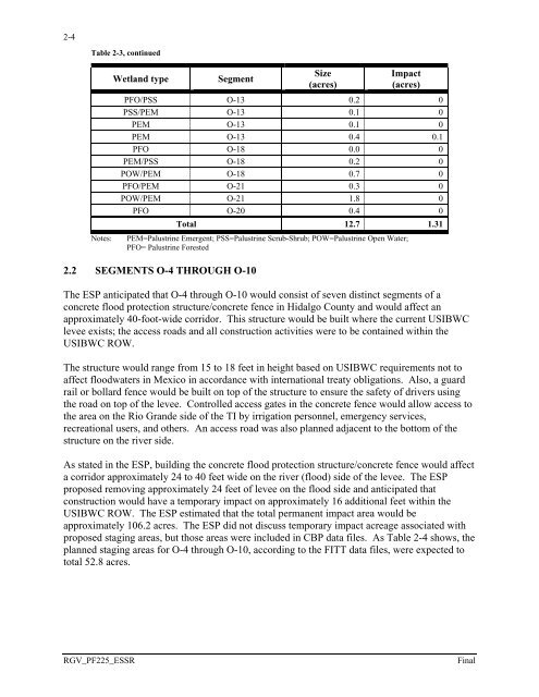
2-4<br />
Table 2-3, continued<br />
Notes:<br />
Wetland type<br />
Segment<br />
Size<br />
(acres)<br />
Impact<br />
(acres)<br />
PFO/PSS O-13 0.2 0<br />
PSS/PEM O-13 0.1 0<br />
PEM O-13 0.1 0<br />
PEM O-13 0.4 0.1<br />
PFO O-18 0.0 0<br />
PEM/PSS O-18 0.2 0<br />
POW/PEM O-18 0.7 0<br />
PFO/PEM O-21 0.3 0<br />
POW/PEM O-21 1.8 0<br />
PFO O-20 0.4 0<br />
Total 12.7 1.31<br />
PEM=Palustrine Emergent; PSS=Palustrine Scrub-Shrub; POW=Palustrine Open Water;<br />
PFO= Palustrine Forested<br />
2.2 SEGMENTS O-4 THROUGH O-10<br />
The ESP anticipated that O-4 through O-10 would consist of seven distinct segments of a<br />
concrete flood protection structure/concrete fence in Hidalgo County and would affect an<br />
approximately 40-foot-wide corridor. This structure would be built where the current USIBWC<br />
levee exists; the access roads and all construction activities were to be contained within the<br />
USIBWC ROW.<br />
The structure would range from 15 to 18 feet in height based on USIBWC requirements not to<br />
affect floodwaters in Mexico in accordance with international treaty obligations. Also, a guard<br />
rail or bollard fence would be built on top of the structure to ensure the safety of drivers using<br />
the road on top of the levee. Controlled access gates in the concrete fence would allow access to<br />
the area on the <strong>Rio</strong> <strong>Grande</strong> side of the TI by irrigation personnel, emergency services,<br />
recreational users, and others. An access road was also planned adjacent to the bottom of the<br />
structure on the river side.<br />
As stated in the ESP, building the concrete flood protection structure/concrete fence would affect<br />
a corridor approximately 24 to 40 feet wide on the river (flood) side of the levee. The ESP<br />
proposed removing approximately 24 feet of levee on the flood side and anticipated that<br />
construction would have a temporary impact on approximately 16 additional feet within the<br />
USIBWC ROW. The ESP estimated that the total permanent impact area would be<br />
approximately 106.2 acres. The ESP did not discuss temporary impact acreage associated with<br />
proposed staging areas, but those areas were included in <strong>CBP</strong> data files. As Table 2-4 shows, the<br />
planned staging areas for O-4 through O-10, according to the FITT data files, were expected to<br />
total 52.8 acres.<br />
RGV_<strong>PF225</strong>_<strong>ESSR</strong><br />
Final