Rio Grande Valley PF225 ESSR - CBP.gov
Rio Grande Valley PF225 ESSR - CBP.gov
Rio Grande Valley PF225 ESSR - CBP.gov

Create successful ePaper yourself
Turn your PDF publications into a flip-book with our unique Google optimized e-Paper software.
3-1<br />
3.0 POST-CONSTRUCTION FINDINGS<br />
This section of the <strong>ESSR</strong> discusses the results of the post-construction surveys in both qualitative<br />
and quantitative terms, by construction activity. During large construction projects it is common<br />
for minor differences between field conditions and design drawings to require small<br />
modifications. These modifications can result in increases in the length of fence sections or the<br />
footprint of roads and staging areas. Changes such as this are expected under typical<br />
construction projects. A summary of the impacts on the pertinent resources, based on these postconstruction<br />
surveys, is presented at the end of this section. Appendix A contains maps of the<br />
various segments and illustrates the location and extent of the impacts.<br />
3.1 RESULTS OF ROAD MEASUREMENTS<br />
3.1.1 Access Roads<br />
The ESP did not discuss impacts associated with access roads in detail, although it identified<br />
numerous access roads for use in various segments. All planned or utilized access roads were<br />
preexisting before building the TI; therefore, no improvements such as widening or straightening<br />
were required in order to use them. Some maintenance and repair activities (grading, filling<br />
holes, and so on) were required. Consequently, the access roads are reported herein as<br />
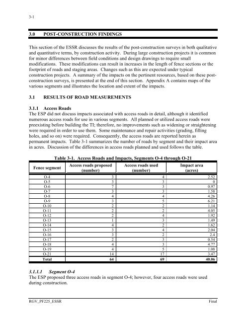
permanent impacts. Table 3-1 summarizes the number of roads by segment and their impact area<br />
in acres. Discussion of the differences in access roads planned and used follows the table.<br />
Fence segment<br />
Table 3-1. Access Roads and Impacts, Segments O-4 through O-21<br />
Access roads proposed<br />
(number)<br />
Access roads used<br />
(number)<br />
Impact area<br />
(acres)<br />
O-4 3 4 2.52<br />
O-5 3 3 0<br />
O-6 7 3 0.97<br />
O-7 3 3 1.58<br />
O-8 4 4 4.26<br />
O-9 3 5 6.21<br />
O-10 2 2 1.14<br />
O-11 2 2 4.05<br />
O-12 2 4 1.92<br />
O-13 1 3 1.49<br />
O-14 4 2 1.62<br />
O-15 3 4 2.04<br />
O-16 3 2 2.4<br />
O-17 2 3 0.54<br />
O-18 4 3 4.77<br />
O-19 4 5 1.08<br />
O-21 14 17 3.47<br />
Total 64 69 40.06<br />
3.1.1.1 Segment O-4<br />
The ESP proposed three access roads in segment O-4; however, four access roads were used<br />
during construction.<br />
RGV_<strong>PF225</strong>_<strong>ESSR</strong><br />
Final