Rio Grande Valley PF225 ESSR - CBP.gov
Rio Grande Valley PF225 ESSR - CBP.gov
Rio Grande Valley PF225 ESSR - CBP.gov

Create successful ePaper yourself
Turn your PDF publications into a flip-book with our unique Google optimized e-Paper software.
3-7<br />
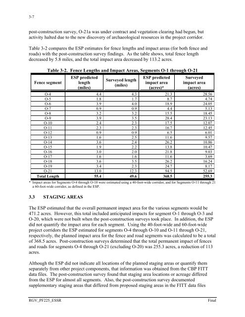
post-construction survey, O-21a was under contract and vegetation clearing had begun, but<br />
activity halted due to the new discovery of archaeological resources in the project corridor.<br />
Table 3-2 compares the ESP estimates for fence lengths and impact areas (for both fence and<br />
roads) with the post-construction survey findings. As the table shows, total fence length<br />
decreased by 5.8 miles, and the total impact area decreased by 113.2 acres.<br />
Table 3-2. Fence Lengths and Impact Areas, Segments O-1 through O-21<br />
Fence segment<br />
ESP predicted<br />
length<br />
(miles)<br />
Surveyed length<br />
(miles)<br />
ESP predicted<br />
impact area<br />
(acres)*<br />
Surveyed<br />
impact area<br />
(acres)<br />
O-4 4.4 4.3 21.3 28.56<br />
O-5 1.8 1.7 8.7 4.74<br />
O-6 3.9 4.0 18.9 24.05<br />
O-7 0.9 0.9 4.4 5.13<br />
O-8 3.2 3.2 15.5 18.45<br />
O-9 3.9 3.5 28.4 23.13<br />
O-10 2.4 2.3 17.5 12.07<br />
O-11 2.3 2.3 16.7 12.45<br />
O-12 0.9 0.9 6.5 6.01<br />
O-13 1.6 2.5 11.6 9.57<br />
O-14 3.6 2.4 26.2 10.86<br />
O-15 1.9 2.2 13.8 10.47<br />
O-16 3.0 2.0 21.8 9.03<br />
O-17 1.6 1.6 11.6 3.69<br />
O-18 3.6 3.5 26.2 16.24<br />
O-19 3.4 2.3 24.7 8.17<br />
O-21 13.0 12.3 94.5 52.69<br />
Total Length 55.4 49.6 368.5 255.3<br />
* Impact areas for Segments O-4 through O-10 were estimated using a 40-foot-wide corridor, and for Segments O-11 through 21<br />
a 60-foot-wide corridor, as defined in the ESP.<br />
3.3 STAGING AREAS<br />
The ESP estimated that the overall permanent impact area for the various segments would be<br />
471.2 acres. However, this total included anticipated impacts for segment O-1 through O-3 and<br />
O-20, which were not built when the post-construction surveys took place. In addition, the ESP<br />
did not quantify the impact area for each segment. Using the 40-foot-wide and 60-foot-wide<br />
project corridors the ESP estimated for segments O-4 through O-10 and O-11 through O-21,<br />
respectively, the planned impact area for the fence and road segments was calculated to be a total<br />
of 368.5 acres. Post-construction surveys determined that the total permanent impact of fences<br />
and roads for segments O-4 through O-21 (excluding O-20) was 255.3 acres, a reduction of 113<br />
acres.<br />
Although the ESP did not indicate all locations of the planned staging areas or quantify them<br />
separately from other project components, that information was obtained from the <strong>CBP</strong> FITT<br />
data files. The post-construction survey found that staging area locations or acreage differed<br />
from the ESP for almost all segments. Also, the post-construction survey documented<br />
supplementary staging areas that differed from proposed staging areas in the FITT data files<br />
RGV_<strong>PF225</strong>_<strong>ESSR</strong><br />
Final