Atlas Final Web Version 6_14
Atlas Final Web Version 6_14
Atlas Final Web Version 6_14

You also want an ePaper? Increase the reach of your titles
YUMPU automatically turns print PDFs into web optimized ePapers that Google loves.
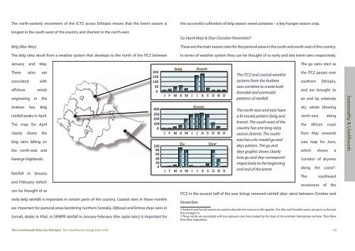
The north-easterly movement of the ICTZ across Ethiopia means that the kremt season is<br />
longest in the south-west of the country and shortest in the north-east.<br />
Belg (Mar-May)<br />
The belg rains result from a weather system that develops to the north of the ITCZ between<br />
the successful cultivation of belg season sweet potatoes – a key hunger season crop.<br />
Gu (April-May) & Deyr (October-November) 2<br />
These are the main season rains for the pastoral areas in the south and south-east of the country.<br />
In terms of weather system they can be thought of as early and late kremt rains respectively.<br />
January and May.<br />
These rains are<br />
associated<br />
offshore<br />
with<br />
winds<br />
originating in the<br />
Arabian Sea. Belg<br />
rainfall peaks in April.<br />
The map for April<br />
clearly shows the<br />
belg rains falling on<br />
the north-east and<br />
Harerge Highlands.<br />
Rainfall in January<br />
and February (which<br />
can be thought of as<br />
early belg rainfall) is important in certain parts of the country. Coastal rains in these months<br />
are important for pastoral areas bordering northern Somalia, Djibouti and Eritrea (heys rains in<br />
Somali, dadac in Afar). In SNNPR rainfall in January-February (the sapia rains) is important for<br />
200<br />
150<br />
100<br />
50<br />
0<br />
400<br />
350<br />
200<br />
100<br />
0<br />
100<br />
80<br />
60<br />
40<br />
20<br />
0<br />
Belg<br />
J F M A M J J A S O N D<br />
J F M A M J J A S O N D<br />
Gu<br />
J F M A M J J A S O N D<br />
The gu rains start as<br />
the ITCZ passes over<br />
southern<br />
Ethiopia,<br />
and are brought to<br />
an end by relatively<br />
dry winds blowing<br />
north-east<br />
along<br />
the African coast<br />
from May onwards<br />
(see map for June,<br />
which shows a<br />
‘corridor’ of dryness<br />
along the coast) 3 .<br />
The<br />
southward<br />
movement of the<br />
ITCZ in the second half of the year brings renewed rainfall (deyr rains) between October and<br />
November.<br />
Kremt<br />
Kremt<br />
Deyr<br />
The ITCZ and coastal weather<br />
systems from the Arabian<br />
seas combine to create both<br />
bimodal and unimodal<br />
patterns of rainfall.<br />
The north-east and east have<br />
a bi-modal pattern (belg and<br />
kremt). The south-west of the<br />
country has one long rainy<br />
season (kremt). The southeast<br />
has a bi-modal gu and<br />
deyr pattern. The gu and<br />
deyr graphic shows clearly<br />
how gu and deyr correspond<br />
respectively to the beginning<br />
and end of the kremt.<br />
2 Amharic and Somali names are used to describe the seasons in this graphic. The Afar and Oromifa names are given in the text<br />
box on page 15.<br />
3 These winds are associated with low pressure over Asia created by the heat of the northern hemisphere summer. They blow<br />
from May-September.<br />
Seasonality & Livelihoods<br />
The Livelihoods <strong>Atlas</strong> for Ethiopia The Livelihoods Integration Unit 13