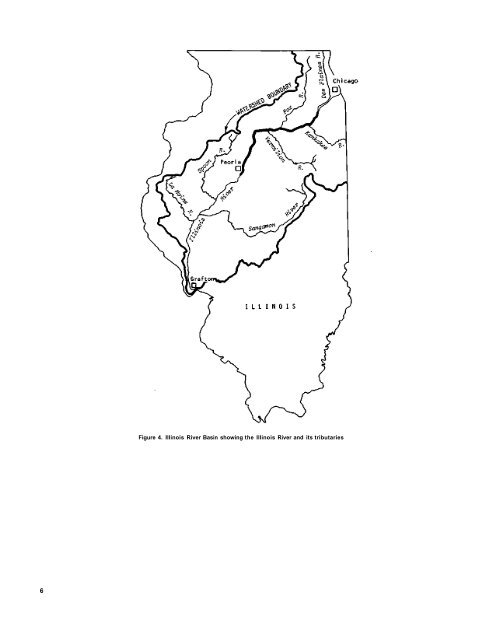
6 Figure 4. Ill<strong>in</strong>ois <strong>River</strong> Bas<strong>in</strong> show<strong>in</strong>g <strong>the</strong> Ill<strong>in</strong>ois <strong>River</strong> <strong>and</strong> its tributaries
Table 1. Waste Discharge Po<strong>in</strong>t Sources to Upper Ill<strong>in</strong>ois W<strong>at</strong>erway Source Mile po<strong>in</strong>t Source Mile po<strong>in</strong>t MSDGC Skokie MSDGC Calumet MSDGC Stickney Gr<strong>and</strong> Calumet <strong>River</strong> Lockport Texaco GAF Corp. U. S. Steel Joliet Ol<strong>in</strong>-Blockson C<strong>at</strong>erpillar Amoco Chemicals Stephen Chemicals Mobil Ref<strong>in</strong>ery Rexene Chemical Glidden Durkee Reichhold Chemical Nor<strong>the</strong>rn Petroleum Co. Federal Paper 336.8 321.4 315.8 325.7 290.9 290.9 289.9 288.9 286.2 284.5 283.6 280.5 280.3 278.0 277.7 276.8 270.5 269.5 264.3 Morris DuPont Corp. N<strong>at</strong>ional Phosph<strong>at</strong>e Ill<strong>in</strong>ois Nitrogen Nabisco Marseilles Marbon Corp. Ottawa LOF Corp. Utica LaSalle Peru Spr<strong>in</strong>g Valley DePue Jones & Laughl<strong>in</strong> Hennep<strong>in</strong> B. F. Goodrich Lacon Chillico<strong>the</strong> 262.8 254.4 249.8 248.7 246.8 246.0 244.3 239.3 237.5 229.6 223.2 222.0 218.0 210.8 208.2 208.2 197.8 188.8 179.0 The Ill<strong>in</strong>ois W<strong>at</strong>erway The Ill<strong>in</strong>ois W<strong>at</strong>erway has three dist<strong>in</strong>ct sections. The uppermost portion <strong>in</strong>cludes <strong>the</strong> Chicago Sanitary <strong>and</strong> Ship Canal <strong>and</strong> its associ<strong>at</strong>ed branches, which extend from Lake Michigan to <strong>the</strong> confluence of <strong>the</strong> Des Pla<strong>in</strong>es <strong>River</strong> (MP 289.9). Approxim<strong>at</strong>ely 17 miles of <strong>the</strong> Des Pla<strong>in</strong>es <strong>River</strong>, between confluences with <strong>the</strong> Chicago Sanitary <strong>and</strong> Ship Canal <strong>and</strong> with <strong>the</strong> Kankakee <strong>River</strong>, is <strong>the</strong> middle section of <strong>the</strong> w<strong>at</strong>erway. The lower <strong>and</strong> <strong>the</strong> major part of <strong>the</strong> w<strong>at</strong>erway is <strong>the</strong> Ill<strong>in</strong>ois <strong>River</strong>. The Ill<strong>in</strong>ois <strong>River</strong> is formed by <strong>the</strong> confluence of <strong>the</strong> Des Pla<strong>in</strong>es <strong>and</strong> Kankakee <strong>River</strong>s (MP 273.0) southwest of Joliet. The river flows westward to DePue where it turns abruptly southwest <strong>and</strong> jo<strong>in</strong>s <strong>the</strong> Mississippi <strong>River</strong> <strong>at</strong> Grafton, above St. Louis (figure 4). The Ill<strong>in</strong>ois <strong>River</strong> is about 273 miles (439 km) long, whereas <strong>the</strong> entire w<strong>at</strong>erway from Lake Michigan to Grafton is 327.2 miles (527 km). The total w<strong>at</strong>ershed area for <strong>the</strong> w<strong>at</strong>erway is about 29,010 square miles (75,140 km 2 ). The w<strong>at</strong>ershed area for <strong>the</strong> w<strong>at</strong>erway <strong>at</strong> <strong>Peoria</strong>, where <strong>the</strong> weekly samples are be<strong>in</strong>g taken, is 14,200 square miles (36,800 km 2 ). Besides <strong>the</strong> Des Pla<strong>in</strong>es <strong>and</strong> Kankakee <strong>River</strong>s, o<strong>the</strong>r major tributaries above <strong>Peoria</strong> are <strong>the</strong> DuPage (MP 276.9), Fox (MP 239.7), <strong>and</strong> Vermilion (MP 226.3) <strong>River</strong>s. The Ill<strong>in</strong>ois W<strong>at</strong>erway is a series of eight navig<strong>at</strong>ion pools cre<strong>at</strong>ed by locks <strong>and</strong> dams to ma<strong>in</strong>ta<strong>in</strong> w<strong>at</strong>er depths needed for commercial barge navig<strong>at</strong>ion. The wastew<strong>at</strong>ers from <strong>the</strong> Chicago area are frequently diluted with Lake Michigan w<strong>at</strong>er diverted through control structures ma<strong>in</strong>ta<strong>in</strong>ed <strong>and</strong> oper<strong>at</strong>ed by <strong>the</strong> Metropolitan Sanitary District of Gre<strong>at</strong>er Chicago (MSDGC). Diversion for dilution purposes by <strong>the</strong> MSDGC is limited to an annual average r<strong>at</strong>e not exceed<strong>in</strong>g 1500 cubic feet per second (cfs) (42.5 m 3 /s). The average flow as measured <strong>at</strong> K<strong>in</strong>gston M<strong>in</strong>es, 16 miles (26 km) downstream from <strong>Peoria</strong>, is about 14,425 cfs (408.2 m 3 /s). The recorded m<strong>in</strong>imum <strong>and</strong> maximum flows are 1810 cfs (51.2 m 3 /s) <strong>and</strong> 83,100 cfs (2350 m 3 /s), respectively. The velocity of streamflow is less than 1 mile per hour (1.6 km/h) <strong>at</strong> normal river stages. The very small hydraulic gradient, an average of 0.267 feet per mile (5.06 cm/km), partially accounts for <strong>the</strong> low flow velocity <strong>in</strong> <strong>the</strong> river. Wastew<strong>at</strong>er Sources There are 16 waste tre<strong>at</strong>ment facilities owned <strong>and</strong> oper<strong>at</strong>ed by municipalities or sanitary districts which discharge effluents directly <strong>in</strong>to <strong>the</strong> Ill<strong>in</strong>ois W<strong>at</strong>erway upstream of <strong>Peoria</strong>. In addition <strong>the</strong> w<strong>at</strong>erway receives discharges from <strong>in</strong>dustries such as petroleum ref<strong>in</strong><strong>in</strong>g, metal f<strong>in</strong>ish<strong>in</strong>g <strong>and</strong> pl<strong>at</strong><strong>in</strong>g, steel, ferment<strong>at</strong>ion <strong>and</strong> distill<strong>at</strong>ion, food, me<strong>at</strong> pack<strong>in</strong>g, paper <strong>and</strong> pulp, fertilizer <strong>and</strong> o<strong>the</strong>rs. 7