Seeing the wood for the trees
Seeing the wood for the trees
Seeing the wood for the trees

Create successful ePaper yourself
Turn your PDF publications into a flip-book with our unique Google optimized e-Paper software.
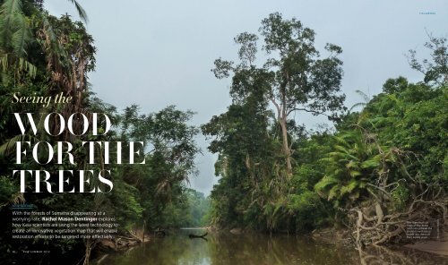
F I E L D W O R K<br />
<strong>Seeing</strong> <strong>the</strong><br />
<strong>wood</strong><br />
<strong>for</strong> <strong>the</strong><br />
<strong>trees</strong><br />
KEW SCIENCE<br />
With <strong>the</strong> <strong>for</strong>ests of Sumatra disappearing at a<br />
worrying rate, Rachel Mason Dentinger explores<br />
how Kew scientists are using <strong>the</strong> latest technology to<br />
create an innovative vegetation map that will enable<br />
restoration ef<strong>for</strong>ts to be targeted more effectively<br />
The rivers that cut<br />
through <strong>the</strong> dense<br />
rain<strong>for</strong>est provide <strong>the</strong><br />
scientists with access<br />
routes into many of<br />
<strong>the</strong>ir survey areas<br />
Photo: Jenny Williams<br />
30 K E W S U M M E R 2 0 1 2
Harapan Rain<strong>for</strong>est botanist<br />
Dafid Pirnanda records <strong>the</strong> plant<br />
species that are present in a<br />
regenerating area of <strong>for</strong>est<br />
<br />
F I E L D W O R K<br />
One hundred years ago, a bird’s-eye view of <strong>the</strong><br />
Indonesian island of Sumatra would have shown<br />
a vast swa<strong>the</strong> of green. Covering an estimated<br />
16 million hectares, this dry lowland rain<strong>for</strong>est was<br />
extremely rich – in species and in <strong>the</strong> resources that humans<br />
covet. Soon enough, logging and oil palm plantations ate<br />
away at that green expanse and today only 500,000 hectares<br />
of <strong>for</strong>est remain. But a team of Kew researchers, armed with<br />
21st-century satellite images and technology, is determined to<br />
help reconstruct a piece of <strong>the</strong> Sumatran rain<strong>for</strong>est – an area<br />
named Harapan or ‘hope’ in Indonesian – and use it as a<br />
foundation <strong>for</strong> regeneration in <strong>the</strong> next century.<br />
Harapan is a 100,000-hectare expanse of rain<strong>for</strong>est that<br />
has been leased <strong>for</strong> <strong>the</strong> next 100 years to a consortium of<br />
conservation experts, namely BirdLife International, Burung<br />
Indonesia (a local non-governmental organisation) and <strong>the</strong><br />
UK’s Royal Society <strong>for</strong> <strong>the</strong> Protection of Birds (RSPB). These<br />
organisations are working to restore <strong>the</strong> <strong>for</strong>est to health.<br />
More ambitiously, <strong>the</strong>y also hope to reinstate <strong>the</strong> original<br />
composition of <strong>the</strong> <strong>for</strong>est prior to human exploitation.<br />
Kew’s botanists have been involved in this undertaking<br />
since 2008, when Rogier de Kok and his team, who specialise in<br />
South-East Asian flora, helped to establish a local herbarium and<br />
trained staff to collect indigenous plants (see Kew magazine,<br />
winter 2009). Earlier this year, in a project funded by <strong>the</strong><br />
Department <strong>for</strong> Environment, Food and Rural Affairs’ International<br />
Sustainable Development Fund, Kew staff returned to Harapan<br />
to carry out ‘a rapid survey <strong>for</strong> <strong>the</strong> whole area’, which, according<br />
to project leader Justin Moat, ‘is what is desperately needed.<br />
This gives an idea of what’s happening on <strong>the</strong> ground, which<br />
can drive restoration planning by <strong>the</strong> <strong>for</strong>est’s managers.’<br />
For over a decade, Justin has headed up Kew’s Geographic<br />
In<strong>for</strong>mation Science (GIS) team generating vegetation maps –<br />
large-scale views of regions that record <strong>the</strong>ir different classes<br />
of vegetation (see Kew magazine, spring 2011). However, <strong>for</strong><br />
many more decades – centuries in fact – generations of Kew<br />
botanists have traversed <strong>the</strong> same regions and have returned<br />
with a very different view of <strong>the</strong> world – one focused on<br />
individual species, where a detailed fine-scale examination of<br />
individual plants is paramount. This field trip brought toge<strong>the</strong>r<br />
<strong>the</strong>se two perspectives on plant life, requiring Kew’s botanists<br />
Photos: Marie Briggs, Roki Afriandi/Harapan Rain<strong>for</strong>est<br />
to break with tradition. Instead of collecting hundreds of<br />
plants to bring back to Kew’s Herbarium, <strong>the</strong>y collected <strong>the</strong><br />
data necessary to summarise and map different vegetation<br />
types within <strong>the</strong> whole of Harapan Rain<strong>for</strong>est.<br />
In <strong>the</strong> first phase of <strong>the</strong> project, geospatial scientist<br />
Jenny Williams used specialised software to analyse <strong>the</strong> few<br />
existing images of <strong>the</strong> region. In an area most often covered<br />
in clouds, she was <strong>for</strong>tunate to obtain a clear satellite image<br />
of <strong>the</strong> <strong>for</strong>est from 2009, with resolution down to 10 m. The<br />
software she uses automatically differentiated <strong>the</strong> rain<strong>for</strong>est<br />
into sections, based on <strong>the</strong> similarities and differences<br />
apparent in <strong>the</strong> vegetation from above.<br />
But what do <strong>the</strong>se sections represent? Even from above,<br />
not all green is equal. In <strong>the</strong> next stage of analysis, Jenny<br />
examined <strong>the</strong> differentiated regions and attempted to roughly<br />
identify <strong>the</strong> type and quality of vegetation <strong>the</strong>y represented.<br />
Is this tract of green a healthy <strong>for</strong>est with a high canopy?<br />
Or is it ‘more uni<strong>for</strong>m and brighter green, perhaps suggesting<br />
bamboo, or unstructured re-growth of a recently de<strong>for</strong>ested<br />
area?’ she questions. Infrared wavelengths add ano<strong>the</strong>r layer<br />
of useful data, as higher quality <strong>for</strong>est tends to reflect infrared<br />
light. Jenny drew on her previous mapping experience<br />
(assessing <strong>the</strong> overwintering sites of monarch butterflies in<br />
Mexico, and orangutan habitat in Borneo) to categorise <strong>the</strong><br />
regions differentiated by <strong>the</strong> software. The result was a<br />
prototype vegetation map of <strong>the</strong> Harapan area.<br />
Finally it was time <strong>for</strong> <strong>the</strong> field team to head to Harapan<br />
<strong>for</strong> ‘ground-truthing’ – visiting each distinct region of vegetation<br />
to test and refine <strong>the</strong> labels <strong>the</strong>y had already been given. Two<br />
teams, each composed of Kew scientists, botanists from <strong>the</strong><br />
Indonesian Bogor Herbarium and Harapan Rain<strong>for</strong>est scientists,<br />
moved swiftly through <strong>the</strong> <strong>for</strong>est, recording data from a<br />
staggering 300 plots along <strong>the</strong> way.<br />
Dwarfed by a towering Gluta tree,<br />
botanists Marie Briggs and Lucia<br />
Lopez use a smartphone to pinpoint<br />
<strong>the</strong>ir location on an electronic map<br />
This type of mass data collection doesn’t come<br />
naturally to botanists, Justin says. ‘We are <strong>for</strong>cing <strong>the</strong><br />
botanists to observe <strong>the</strong> landscape. “Look around you,”<br />
we tell <strong>the</strong>m, “we don’t need to focus on individual plants<br />
now.”’ Botanists may sometimes miss <strong>the</strong> <strong>for</strong>est <strong>for</strong> <strong>the</strong><br />
<strong>trees</strong>, but here in Harapan <strong>the</strong> <strong>for</strong>est was <strong>the</strong>ir primary<br />
focus. ‘This is mainly about observing what’s going on,<br />
on <strong>the</strong> ground, about recording <strong>the</strong> in<strong>for</strong>mation within<br />
each 500 sq m plot,’ says Justin. This includes <strong>the</strong> size of<br />
<strong>the</strong> <strong>trees</strong> and <strong>the</strong> height of <strong>the</strong> canopy, <strong>the</strong> dominant tree<br />
species in a plot and evidence of negative impacts on <strong>the</strong><br />
<strong>for</strong>est, such as illegal logging and invasive species. ‘Then we<br />
can place in<strong>for</strong>mation back onto <strong>the</strong> imagery,’ explains Justin.<br />
Kew researchers are determined to help<br />
reconstruct a piece of rain<strong>for</strong>est in an area<br />
named Harapan or ‘hope’ in Indonesian<br />
32 K E W S U M M E R 2 0 1 2 w w w . k e w . o r g w w w . k e w . o r g<br />
K E W S U M M E R 2 0 1 2 33
F I E L D W O R K<br />
Harapan’s threatened rain<strong>for</strong>est<br />
is home to many intriguing and<br />
eye-catching plants, including<br />
this vivid-fruited species in <strong>the</strong><br />
family Sterculiaceae<br />
Kew’s Marie Briggs ga<strong>the</strong>rs data on<br />
<strong>the</strong> edge of a swamp <strong>for</strong>est amid <strong>the</strong><br />
fallen flowers of a Barringtonia tree<br />
– a characteristic species of this area<br />
Photos: Roki Afriandi/Harapan Rain<strong>for</strong>est, Marie Briggs, Jenny Williams<br />
Both <strong>the</strong> collection and analysis of this immense amount<br />
of data are made possible by <strong>the</strong> savvy use of technological tools.<br />
Team members recorded data from each plot on smartphones<br />
that were pre-loaded with maps of <strong>the</strong> region and <strong>the</strong> relevant<br />
data fields. Their phones guided <strong>the</strong>m to <strong>the</strong> target sites within<br />
<strong>the</strong> <strong>for</strong>est and helped <strong>the</strong>m fluidly adjust <strong>the</strong>ir expectations and<br />
daily research plans based on what <strong>the</strong>y found. Each evening<br />
<strong>the</strong> amassed data was uploaded and transferred to Justin,<br />
who worked back at Kew to create a live map. The map, which<br />
can be viewed on <strong>the</strong> GIS team’s webpages, also includes<br />
geo-tagged photographs and tweets from <strong>the</strong> field.<br />
Jenny’s job now is to take <strong>the</strong>se discrete points of data and<br />
create a two-dimensional summary of <strong>the</strong> state of <strong>the</strong> <strong>for</strong>est in<br />
<strong>the</strong> whole region. The practical value of this vegetation map is<br />
best understood in terms of <strong>the</strong> investment required to restore<br />
Harapan. ‘We are trying to work out essentially where to put<br />
<strong>the</strong> ef<strong>for</strong>t in and where not to put <strong>the</strong> ef<strong>for</strong>t in,’ explains Justin.<br />
‘Some parts of <strong>the</strong> <strong>for</strong>est can be left alone to recover, but if any<br />
area needs some help, we can show where <strong>the</strong>y get <strong>the</strong> best<br />
bang <strong>for</strong> <strong>the</strong>ir buck.’ While almost all of Harapan Rain<strong>for</strong>est<br />
has been logged in <strong>the</strong> past, and some of it continues to be<br />
threatened by illegal logging today, <strong>the</strong> Kew team has returned<br />
from Sumatra with good tidings. Much of <strong>the</strong> <strong>for</strong>est is already<br />
on its way to recovery and Harapan Rain<strong>for</strong>est itself is proving<br />
to be a great restoration investment.<br />
And, if Rogier has his way, Kew’s botanists should soon<br />
have a chance to leave this large-scale view of <strong>the</strong> <strong>for</strong>est behind<br />
and get back to <strong>the</strong>ir higher-resolution examination of <strong>the</strong><br />
plants, as he hopes to conduct a detailed survey of Harapan’s<br />
flora. Understanding <strong>the</strong> species-level composition of <strong>the</strong> <strong>for</strong>est<br />
is just as essential to restoration as <strong>the</strong> creation of a vegetation<br />
map. The custodians of Harapan want to encourage <strong>the</strong> return<br />
of <strong>the</strong> original <strong>for</strong>est, but ‘what that actually means is ano<strong>the</strong>r<br />
matter’, Rogier points out. Botanists will need to account <strong>for</strong><br />
<strong>the</strong> species that thrive in Harapan today, but <strong>the</strong>y will also be<br />
asked to hypo<strong>the</strong>sise about <strong>the</strong> historical composition of <strong>the</strong><br />
<strong>for</strong>est. ‘They want to restore <strong>the</strong> <strong>for</strong>est to some sort of natural<br />
state’, Rogier says, but ‘is that what it was be<strong>for</strong>e human<br />
intervention, or is that what is possible?’<br />
Kew scientists can provide two scales of analysis –<br />
large and small – which attempt to describe both what<br />
is in Harapan today and what once was. By creating a<br />
management plan that syn<strong>the</strong>sises <strong>the</strong>se two perspectives,<br />
<strong>the</strong> <strong>for</strong>est’s managers can determine what can be in<br />
Harapan Rain<strong>for</strong>est <strong>for</strong> <strong>the</strong> next one hundred years.<br />
––<br />
Rachel Mason Dentinger is a freelance science writer<br />
»»<br />
Kew’s vegetation mapping project of Harapan Rain<strong>for</strong>est<br />
has been made possible thanks to a grant from <strong>the</strong> Department<br />
<strong>for</strong> Environment, Food and Rural Affairs. Its results – and Kew’s<br />
expertise in South-East Asian flora – will be used to guide <strong>the</strong><br />
restoration of this dry lowland rain<strong>for</strong>est<br />
Discover more online<br />
Harapan Rain<strong>for</strong>est is located on Sumatra, <strong>the</strong> largest island <br />
in Indonesia. The dry lowland <strong>for</strong>ests of Sumatra are among <strong>the</strong> <br />
most biologically diverse yet most critically threatened habitats <br />
on Earth. A consortium of <strong>the</strong> RSPB, Burung Indonesia and <br />
BirdLife International manages Harapan Rain<strong>for</strong>est – see <br />
harapanrain<strong>for</strong>est.org. You can find out much more about <strong>the</strong><br />
Kew project, including photos, maps, tweets and fascinating <br />
blogs, by going to www.kew.org and searching <strong>for</strong> ‘Harapan’.<br />
Jenny Williams, Lucia Lopez<br />
and <strong>the</strong> team pore over a<br />
satellite image of Harapan<br />
to work out <strong>the</strong> best ways<br />
34 K E W S U M M E R 2 0 1 2 to reach <strong>the</strong>ir survey areas<br />
w w w . k e w . o r g w w w . k e w . o r g<br />
K E W S U M M E R 2 0 1 2 35